© 2022, IRJET | Impact Factor value: 7.529 | ISO 9001:2008 Certified Journal | Page855

p ISSN: 2395 0072
2,3,4Student, Dept. of Information Technology, Vivekanand Education Society’s Institute of Technology, Mumbai University, Mumbai, India ***
International Research Journal of Engineering and Technology (IRJET) e ISSN: 2395 0056
Initially,thesourceanddestinationaddressforwhichuser wants to travel the route has been provided by the user. By using various libraries of python, tracking of all the possibleroutesandtheoptimumamongstthemwasdone using data science techniques. Dijkstra’s Algorithm was usedforgettingthelocalityofpointsoftheshortestroute and Kalman Filtration Technique on those points was applied to get a clean and smooth path on the map. Scattermapboxwasusedasthemeansofrepresentingthe route over a map. Nearby amenities, weather and
1. INTRODUCTION
The problem statement is “Location Tracking and Smooth PathProvidingSystem”.Theprojectaimedatdeliveringan optimizedroutefromsourcetodestinationbytrackingthe real time coordinates, displaying nearby amenities and facilities through the route, weather conditions and thereby providing the approximate travel time for the same.Also,sharingof currentlocationwithothersincase needed,isalsoembeddedintheproject.
GPS is used for tracking vehicles and keeps regular monitoring. Atmospheric conditions including temperature,pressure,andhumiditycancausecalculation andaccuracyerrorsinthesatellitenetwork.Totacklethis, a research paper[4], proposed a path planning approach which refers to finding a collision free and feasible path from the given initial to final configuration and reshaping path, along with a detailed approach of graph search and optimization based algorithms. Also, a paper[5] published gives deep insight into Dijjsktra’s algorithm. It provides the approach for resolving the surface optimal path planningusingextendedDijsktra’salgorithm.Researchers had deployed various map matching algorithms which combined the concepts from Kalman Filter and advanced map matching algorithms for providing path at every curvature using the best segment selection approach based on the information about weight of closeness, direction difference which resulted in processing less amount of data[6]. A dynamic approach to predict travel time in real time using data driven techniques and comprehensive data sources provided insightful information regarding mathematical formulas for computing travel time required for finding the optimal path[7]
Smita Jangale1, Rutuja Rajhans2, Anuja Shetye3, Ritik Wadhwani4
Here comes the need for implementing a convenient and handy system for real time location finding and getting a smooth and accurate path to destination. Also in the current scenario, for traveling from a source point to a destinationpoint,onehasalotofroutestochoosefrom,so which one to choose from, so as the overall route is shortestandthetraveltimeisreduced.Toaddressthis,an idea was thought of implementing a project titled “LocationTrackingandSmoothPathProvidingsystem”.
1.2 PROPOSED SOLUTION
1.1 RELATED WORK
1Professor, Dept. of Information Technology, Vivekanand Education Society’s Institute of Technology, Mumbai University, Mumbai, India
Location Tracking and Smooth Path Providing System
Volume: 09 Issue: 03 | Mar 2022 www.irjet.net
In this modern era, vehicles are fully dependent on GPS service's accuracy and digital road map quality instead of physically searching for the road routes. Even with the most up to date mapping and navigation software, GPS tracker is still at the mercy of its satellite network. Accuracy problems can arise from atmospheric to terrestrial. When a satellite isn’t able to transmit its positionduetoorbitalerror,itwon’tbeabletoestablisha linkwithaGPStracker.
Abstract The project paper entitled “Location Tracking and Smooth Path Providing System'' focuses on the objectives, methodology and the implementation of the created system. As the GPS signals are not that reliable due to some issues on low frequency data; it is a challenging task for finding real time location coordinates and getting an accurate travel route. So, a solution was proposed for catering the goals of the project by making use of the Machine Learning and Data Science Algorithms. Literature survey was done through some of the research papers of IEEE, Springer, ScienceDirect which provided a precise information and view regarding location measurement, turn analysis, route analysis methods, computing travel time and algorithms like Dijsktra’s Algorithm for providing with the shortest route and Kalman filter for smoothening of the track. In some way, the system will have a huge impact on traffic management, and would also help to cater the needs for providing precise paths thereby benefiting the people and would reduce their efforts to travel an extra mile. The system is user friendly and provides results in good deliverable time.
Key Words: Low frequency data, location measurement, turn analysis, route analysis methods, Kalmanfilterandsmoothingalgorithm,API.
● GoogleColab platformformakingthesystem
2.Plotly The plotly library is an interactive, open source plotting library which was used in plotting the route over 3.map.flask
2.4 TECHNIQUES/ ALGORITHMS STUDIED
1. Dijkstra’s Algorithm Dijkstra's algorithm is the iterative algorithmic process which was used to provide the shortest path from one specific starting node to all othernodesofthegraph.
The system was deployed using Flask which is a Web Framework in python for providing user friendly and convenientinterfaceaccessfortheuser.
● Disk Space on Colab notebook 46.32 GB/107.72 GB
temperature conditions and current location of the user were fetched through API. Travel time was predicted so theusercandecidehisjourneybeforehand.
● OpenCageAPI forgeocoding
2.2 HARDWARE REQUIREMENTS
4.OSMnx It was used for downloading geospatial data from OpenStreetMap and model, project, visualize, and analyze real world street networks and other geospatial 5geometries.NetworkX
4.algorithm.Euclidean Algorithm It was used to get the nearest or neighbourhood point from the desired point for accuracy withoutalteringtheprocess.
Volume: 09 Issue: 03 | Mar 2022 www.irjet.net
International Research Journal of Engineering and Technology (IRJET) e ISSN: 2395 0056
2.KalmanFilterandSmoother Kalmanfilteralgorithmis an iterative mathematical process which was used to detect and estimate the true value, position, velocity, etc
2.3 PYTHON LIBRARIES USED
p ISSN: 2395 0072 Factor value:
7.529 | ISO 9001:2008 Certified Journal | Page856
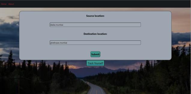
:Blockdiagramofthesystem
2. PROJECT METHODOLOGY
DIAGRAMFig-1
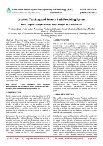
Fig 4.1:HomePage
3. BLOCK
3. Map Matching Algorithm A link for a smooth and reliablepathontheroadwasprovidedbyamapmatching
OpenCage Geocoder API The OpenCage Geocoding API providesaccuratereverse(latitude/longitudetotext)and forward (text to latitude/longitude) geocoding via a RESTful API. The user provided physical address was convertedintomapcoordinatesusingOpenCage.Accurate existing address was the necessary condition for getting thenextstepstobedone.
● GoogleMapAPI forretrievingcurrentlocation
2.1 SOFTWARE REQUIREMENTS
6.Jinja 2 Itwasusedforprovidingawebtemplateengine forthesystem.
of an object or motion of an object, when the measured valueshadunpredicted,errororvariation.
© 2022, IRJET | Impact
1.Numpy Itprovideda multidimensional arrayobject, as wellasvariationssuchasmasksandmatrices,whichwere usedforvariousmathoperations.
Google API Google APIs are application programming interfaces developed by Google which allow communicationwithGoogleServicesandtheirintegration
ngrok Thislibrarywasusedtomaketheurlofthe webapppublicsothatitcanbeusedwithcolab.
● OpenWeatherMap API for retrieving weather andtemperaturedata
It was used for the creation, manipulation, and study of the structure, dynamics, and functions of complexnetworks.
● Flask fordeployingthesystem
4. A)IMPLEMENTATIONGettingthesource and destination address from the user
● RAMonColabnotebook 0.77GB/12.69GB
Many libraries can be used to plot a path using various APIs, but this leads to reduced flexibility. Also, on many occasions, a user may want some flexibility of not only having one path between two points but also multiple pathswhichhecanselectfrom,forexample:userwantsto lookforalltheexistingroutesbeforehand.
NetworkX The k_shortest_paths function of OSMnX retrieved all the possible paths and the shortest_path function of NetworkX implemented Dijkstra’s Algorithm internally for obtaining all the points from start node to end node from the graph such that the path was shortest. The shortest_path _length function provided the approximatetraveltimeinminutes.So,aftergettingallthe routes, the latitude and longitude of all the nodes to be plottedonthemapwasstored.
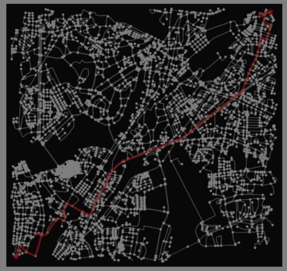
Fig 4.4:Redpathsdenotingalltheexistingroutes
International Research Journal of Engineering and Technology (IRJET)
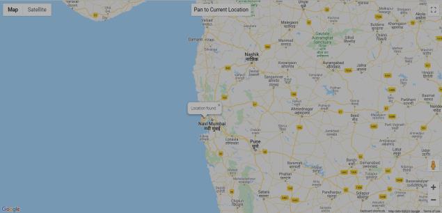
Fig -4.2:Mapfileofuser’scurrentlocation
p ISSN: 2395 0072
to other services. The track yourself facility used the API for getting the current location of the user. Below is the map file that gets generated which can be shared with others.
© 2022, IRJET | Impact Factor value: 7.529 | ISO 9001:2008 Certified Journal | Page857
B) Processing on the obtained coordinates from user
VisualizingwasdoneusingtheOSMnXpackage.
Possibleroutesandtheshortestonewasobtainedthrough theNetworkXpackage.
Thebelowgraphdepictstheshortestpath.
b: Getting all the possible routes and the shortest one
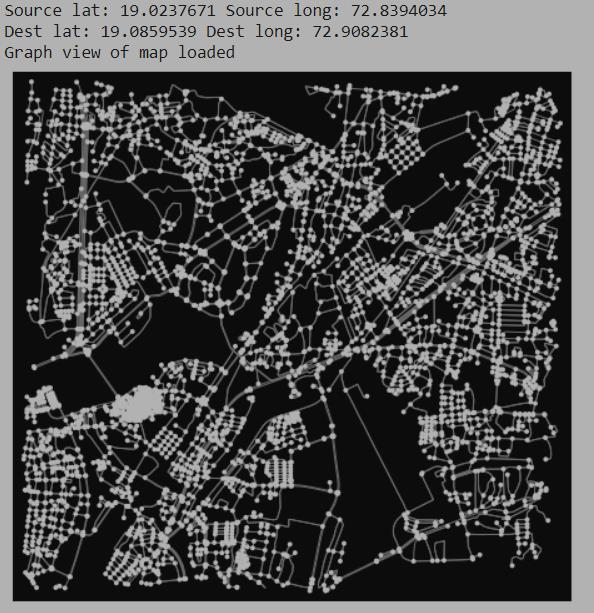
Belowistheillustrationofthegraphobject.
e ISSN: 2395 0056
OSMnX OSMnx downloads the map as a graph object whichcaneasilybeusedbytheNetworkXlibrary.So,with the coordinates obtained from OpenCage, the graph structure of the road network was visualized. The graph view was not just a stationary image but it had a lot of information that was used for plotting routes. The edges or lines in the graph denoted the roads and the nodes or points in the graph denoted endpoints of the roads. Also, the edgesand nodes wereassociatedwithunique id, map coordinates,geometry,andnamesothattheycanbeused for plottingoverthemap.The nearest node wasobtained to source point and destination point respectively using theget_nearest_nodefunctionbyEuclidean’sAlgorithmof OSMnX for plotting routes between them as the exact coordinateswerenotavailableonthegraph.
Fig 4.3:Graphstructureoftheroadnetwork
a. Visualizing the graph view of road network between the source and destination -
Volume: 09 Issue: 03 | Mar 2022 www.irjet.net
From the below figure, all the existing routes can be visualizedonthegraphbeforeplottingthemontheactual map.Thenodesareconnectedtogethertoformapath.
FilterKalman Description Output
A stateestimatedsmoothofnodes
The Kalman Filter Algorithm is an iterative mathematical process. It detects or estimates the true value or position ofapointwhenthemeasuredvalue containsunpredicted, error or variation. This algorithm was estimated on the latitude and longitude of the shortest path. Two algorithms for tracking were implemented : the Kalman Filter and Kalman Smoother with the help of Pykalman module of python. Three filters were used and finally points of the shortest route to be plotted over the actual mapwereobtained.
I It took an initial guess of state estimate and initial guess of error covariance matrix as input and transition matrix where last state of nodes was updated to reflect the current state and observation matrix where current state of nodes was transformed to the best estimate of the system.
p
Table 1:KalmanFilter&Smootherestimation
III Herethefinalfilterwasused onthe line. The wasestimationFilterwayseconds.In0.00111stagethirdseconds0.00146requiredsecondseconds,0.0008659processtheofaveragestages.ThecarriedIIIKalmanprocessthesecondsIIIKalmanandTimeThethempathprovidedpointsconsideredplottheandathroughtoo.averagetobuildtrainFilterwas0.9103andupdationoffilterwasalsoin3timefirststageofupdationwasstageandupdationrequiredthisKalmandone.
c: Kalman Filter estimation on the shortest route
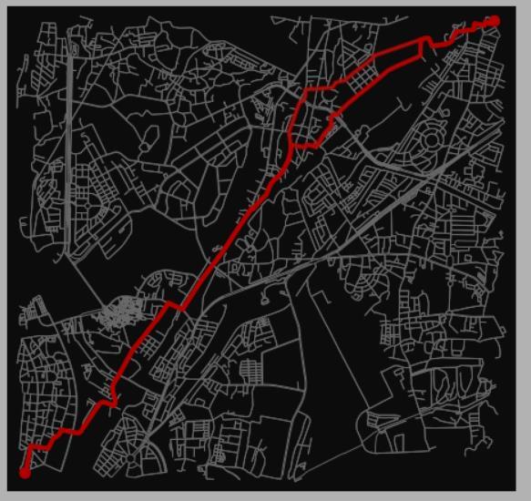
Fig -4.5:ShortestroutebyDijkstra’sAlgorithm
Volume: 09 Issue: 03 | Mar 2022 www.irjet.net ISSN: 2395 0072
was fixed to 1000 times to thatofthefirstKalmanfilter observationcovariance.
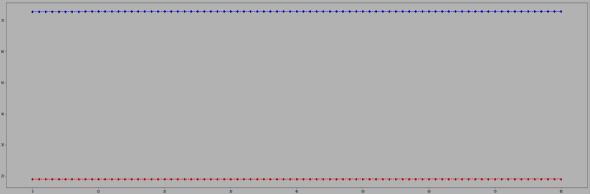
It did a reasonable job of noise.rejecting
The next step after getting the shortest path was to simplify and smoothen the path.The goal was to reduce thenumberofpointswhichwerequiteinconsistentonthe path to get a precise and optimized path without any inconsistency. This was done with the help of Kalman FilterandSmootherAlgorithm.
International Research Journal of Engineering and Technology (IRJET) e ISSN: 2395 0056
Fig 4.6a:I
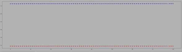
Fromthebelowthreefigures,thebluelinedepictslatitude coordinatesandredlinedepictslongitudecoordinates. KalmanFilter
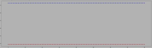
II It took an extra parameter i.e. observation covariance and to avoid reestimation it
© 2022, IRJET | Impact Factor value: 7.529 | ISO 9001:2008 Certified Journal | Page858
wasobtained.
“Colab” for short, is a product fromGoogleResearch.Colaballowsanybodyto writeand executearbitrarypythoncodethroughthebrowser,andis especially well suited to machine learning, data analysis andeducation.
Volume: 09 Issue: 03 | Mar 2022 www.irjet.net ISSN: 2395 0072
Research
6. SCOPE
Opencage API was used for picking out the coordinates over the optimized route which represented an amenity like restaurant, shop, cinema, cafe, education related institutes like schools, colleges and clinics, hospitals for plottingthemasmarkers.
ACKNOWLEDGEMENT
Wewouldliketothankourmentor,Mrs.SmitaJangalefor guiding us and enabling us to make sense of all the information regarding the project and also thankful towards the authors of the papers we have referred for providinguswiththebetterunderstandingoftheproblem statementandgratefultowardseveryone.
To provide the user with the accurate results in less deliverable time is the scope of the project. The system is quiteuserfriendlyandinteractive.Thescopeboundary is that the user needs a good internet connectivity and a smartdevice.Noneedtologinusingthesystem.
© 2022, IRJET | Impact Factor value: 7.529 | ISO 9001:2008 Certified Journal | Page859
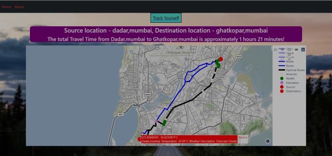
Scatter Map was used for plotting purposes. Scatter Map allowedtovisualizegeographical data asdata pointsona map. The Plotly library plots all the nodes and connects themwithlinestorepresentapath.Soaftercollectingand compilingeverythingtogether,thefinalroutewasplotted on the map along with the multiple routes, travel time, nearby amenities, weather and temperature data, source, destination and notations. The below figure is the snapshotthattheuserviewsafterclickingonsubmit.
p
e: Getting weather and temperature conditions
Thus the project entitled “Location Tracking and Smooth PathProvidingSystem”wassuccessfullyimplementedand developed by taking care of all the possible constraints. The average waiting time for the system to provide the resultsissatisfactory.
Fig 4.6b:IIKalmanFilter
4.7
Fig 4.6c:IIIKalmanFilter
C) Plotting the final route on Map
OpenWeatherMap API was used for this purpose. It is an online service, owned by OpenWeather Ltd, that provides global weather data via API, including current weather data, forecasts, nowcasts and historical weather data for any geographical location. So, the temperature and weather data was retrieved from the API for the source anddestinationaddress.
d: Fetching various amenities and facilities through the optimized route
5. RESULTS AND DISCUSSIONS
1. API API is an acronym for Application Programming Interface that software uses to access data, server softwareorotherapplications.APIsareveryversatileand can be used on web based systems, operating systems, databasesystemsandcomputerhardware.
Fig :Finalmapseenbyuser
International Journal of Engineering and Technology (IRJET) e ISSN: 2395 0056
7. CONCLUSION
8. APPENDIX
Insomeway,thissystemwillhaveahugeimpactontraffic management, and would also help to cater the needs for providingprecisepathstherebybenefitingthepeopleand would reduce their efforts to travel an extra mile. The system was user friendly and provided the results in less deliverable time. The time taken to build and train the Kalman Filter was 1.412 seconds which would be further improved to give a better accuracy. The main objective to have an accurate path selection process on appropriate road networks and design an approach which minimizes storage requirements while not compromising on the predictionaccuracywasachieved.
3.application.GoogleColaboratory
Definitions:
2. Flask Flask is a web framework. It provides tools, libraries and technologies that allows one to build a web
Treinish, Ivan Carvalho, Georgios Tsilimis Gounakis, Nahum Sa, “networkx: A high performance graph library for python”, Attribution 4.0 International License(CCby4.0)
[7]HomaTaghipour,AmirParsa,Abolfazl Mohammadin,“A dynamicapproachtopredict traveltimeinrealtimeusing data driven techniques and comprehensive data sources”, Elsevier(2020)HashemiM.,KarimiH.A.,“Acritical review ofreal timemap matching algorithms: Currentissuesand future directions”, Computers, Environment and Urban Systems48,153 165(2014)
REFERENCES
International Research Journal of Engineering and Technology (IRJET) e ISSN: 2395 0056
[4] Chaoyi Sun, Qing Li, Li Li, “A grid map path reshaping algorithm for path planning”, In:2019 IEEE major project “New generation Artificial Intelligence”
[8] HuG.,Shao J.,LiuF., WangY., ShenH.T.,”If matching: Towardsaccuratemap matchingwithinformationfusion”, IEEE Transactions on Knowledge and Data Engineering 29(1),114 127(2017)
[10]2017.05.004Matthew
[2] Aric A. Hagberg, Daniel A. Schult, Pieter J. Swart, “Exploring Network Structure, Dynamics and Function usingNetworkX”,proceedingsofthe7thpythoninScience Conference(SciPy2008)
BIOGRAPHIES
[3] Goh C.Y., Dauwels J., Mitrovic N., Asif M.T., Oran A., Jaillet P., “Online map matching based on hidden markov model for real time traffic sensing applications”, In: 2012 15th International IEEE Conference on Intelligent TransportationSystems.pp.776 781.IEEE(2012)
Volume: 09 Issue: 03 | Mar 2022 www.irjet.net
© 2022, IRJET | Impact Factor value: 7.529 | ISO 9001:2008 Certified Journal | Page860
[1] Bonnifait, P., Laneurit J., Fouque C., D'herbomez, G., “Multi hypothesis map matching using particle filtering”, In:16thWorldCongressfor ITSSystemsandServices.pp. 1 8(2009)
underChina.[5]MinLuo, Xiaorong Hou, Jin Yang, “Surface optimal path planning using an extended Dijkstra Algorithm”, In:2020IEEEvolume8.
p ISSN: 2395 0072
[9] Geoff Boeing, “OSMnx: New Methods for Acquiring, Constructing, Analyzing, and Visualizing Complex Street Networks”, July2017ComputersEnvironmentandUrban Systems 65:126 139, DOI: 10.1016 /j.compenvurbsys.
[6] S.K.Prasad, J Rachna, O.I.Khalaf, D. N. Le, “Map MatchingAlgorithm: Real timelocationtracking forsmart security Application”, Telecommunication and Radio Engineering,79(13):1 14(2020)
Prof. Smita Jangale is the Deputy Head of Information Technology Department at Vivekanand Education Society’s Institute of RutujaTechnology.Rajhans is currently pursuing her B.E. in Information Technology from Vivekanand Education Society’s Institute of AnujaTechnology.Shetye is currently pursuing her B.E. in Information Technology from Vivekanand Education Society’s Institute of RitikTechnology.Wadhwani is currently pursuing his B.E. in Information Technology from Vivekanand Education Society’s Institute of Technology.