Department of Civil Engineering, College of Engineering, Universiti Tenaga Nasional 2Institute of Energy Infrastructure, Universiti Tenaga Nasional 3Department of Irrigation and Drainage, Malaysia ***
Abstract In recent years, Debris and Mud flow occurs more frequently in landslide prone areas in Malaysia such as Hulu Kelang, Penang and especially Cameron Highlands. It is the most catastrophic type of landslides as it causes extensive property damage and casualties. The disaster effect can be minimized if we could predict spatially and temporally the impending event. As the susceptibility map of Cameron Highlands was established by the Department of Mineral and Geosciences, Malaysia in 2016, the temporal prediction serves to fill the lack of the warning system. The main triggering parameter of Debris and mud flow is rainfall and the data are more promptly acquired; therefore, this information is very crucial to investigate the correlation of the corresponding rainfall and the soil water index of the Debris and Mudflow in Cameron Highlands. The study adopts the tank model to calculate the soil water index. This method has been implemented by the Japan Meteorological Agency in their alert issuing system. 20 numbers of debris and mud flow were recorded in Cameron Highland from 1994 to 2020 and were investigated. The results show that the debris and mud flow are affected by the monsoon and during the prolonged rainfall whereby the continuous rainfall is more than 80mm. The SWI for debris and Mud flow in Cameron Highland is 61 on average. The findings in this study can be an input of the disaster management plan and responsible agencies in delivering the warning to the local community.
Key Words: Temporal forecasting, Debris, Mudflow, 1.INTRODUCTIONHighlandsSoilWaterIndex,DisasterManagement,SWI,Cameron Debris and mud flow as described by Dikau et. al. [1] is a landslide in which the individual particles travel separatelywithinamovingmasswhileVarnes[2]defined it as descending and outward movement of slopeforming run out affected by the gravity. It is one of the sediment related disasters that disastrous and causes fatalities. Apart from the geological and morphology setting of the affectedareaaswellasthehumanactivity,itisagreedthat the rainfall is the main triggering factor for debris and mud flow to occur [3 5]. Due to the magnitude and frequency of such incidents, several studies have been made to estimate critical rainfall conditions that induce landslides. As suggested by Chen and Fujita [6], rainfall based warning system is the most used sediment disaster warningsystemswhileKeefer etal.[7]describedthatthe systemforissuingwarningsoflandslidesinFranciscoBay Region, California is based on empirical and theoretical relationsbetweenrainfallandlandslideinitiation,geologic determinationofareassusceptibletolandslides,real time monitoring of rain gauges and precipitation forecasts. Malaysia,ontheotherhandhaddevelopedthecorrelation based on the rainfall threshold mostly for shallow landslideandmajorlandslidebutnotyetimplementedthe threshold as an operational warning model. The compilation of the studies is summarized in Table 1. The compilation shows that the threshold is based on the empirical model that represents the relationship of surface rainfall and event and less focusing on debris and mud flow. While there is a lack of follow up on the conceptual model that is more representative of the hydro metrological process, therefore, this study adopts theSoil WaterIndex(SWI) asa proxytocalculate thesoil water content that initiated the debris and mud flow. The method considered the surface runoff, infiltration of rainfall to the underground and the discharge of the subsurface. As the works of Kuraoka & Mori [12], Mukhilisin et al. [13], and Matlan,et al. [15] did not determined the SWI value of their area of interest, Hulu KelangandRanau,Sabahrespectively,thereforethisstudy aimtodeterminetheSWIvaluefordebrisandmudflowin CameronHighlands,Malaysia.
International Research Journal of Engineering and Technology (IRJET) e ISSN: 2395 0056 Volume: 09 Issue: 02 | Feb 2022 www.irjet.net p ISSN: 2395 0072 © 2022, IRJET | Impact Factor value: 7.529 | ISO 9001:2008 Certified Journal | Page1001

1
Sandra Ligong1 , Lariyah Mohd Sidek2 , Norlida Mohd Dom3, Khairul Adzim Saadon3
Determination of Rainfall Characteristics and Soil Water Index for Debris and Mud Flow in Cameron Highlands, Malaysia
Journal
1.2DebrisandMudFlowinCameronHighlands
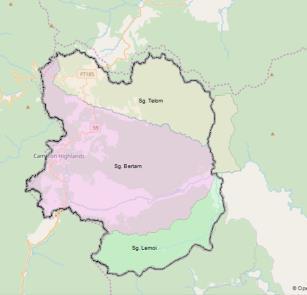
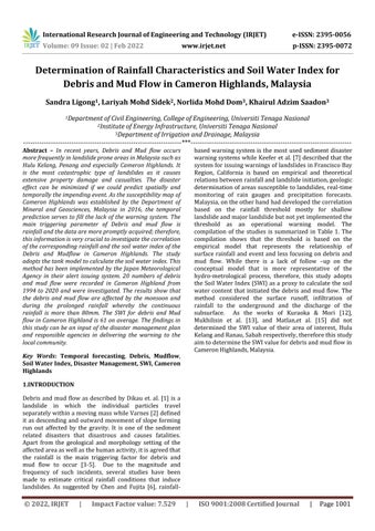
Fig 1: CameronHighlandscatchment
Page1002
Table-1:SummaryofrainfallthresholdstudyinMalaysia
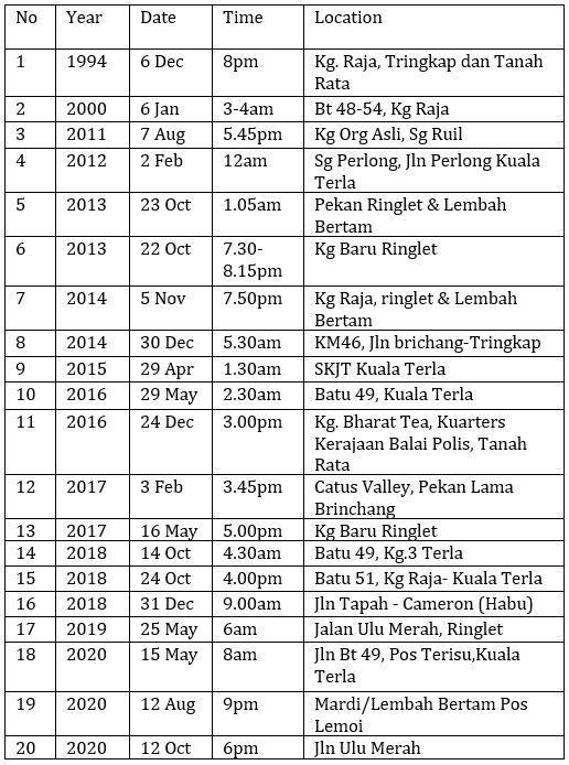
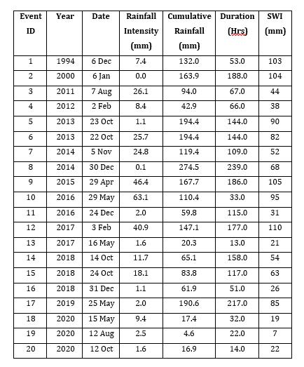
Table-2: HistoricalDebrisandMudflowIncidentin CameronHighlands
International Research Journal of Engineering and Technology (IRJET) e ISSN: 2395 0056 Volume: 09 Issue: 02 | Feb 2022 www.irjet.net p ISSN: 2395 0072 © 2022, IRJET | Impact Factor value: 7.529 | ISO 9001:2008 Certified |
Note:DMF=debrisandmudflows,I D=rainfallintensity duration threshold, E3 API30 = cumulative 3 day rainfall 30 day antecedent precipitation index threshold, Ip D = highest rainfall intensity duration threshold, SWI = soil waterindex,I=rainfallintensity,D=rainfallduration,Ip= highest rainfall intensity, E3 = cumulative 3 day rainfall amount,API30 =30 dayantecedentprecipitationindex. 1.1StudyArea Cameron Highlands is one of the districts in Pahang, Malaysia. It is located between latitude 4.620034°N and 4.321226°N, and between 101.332293°E and 101.608324°E. The catchment area is 712km2 compromises 3 major river catchment systems namely Telom Catchment in the North, Bertam catchment in the middle of the district and Lemoi Catchment. Both catchments are highly cultivated in the upstream region with several town centers while the Lemoi catchment is entirely in the jungle. The landscape of the Cameron Highlands is hilly with the elevation between 1,135m to 1,829mabovesealevel.Morethan66%ofslopegradientis 20° deriving dominantly from granitic development with many separation points and regions showing sedimentary arrangement at the western limits. Cameron Highlands receivedannualrainfall3000mmonaveragewhileTaiwan 2500mm and Japan 1700mm. Since the 1900s, Cameron Highlands experienced rapid growth in terms of new land opening,deforestryforthepursuitofagriculturaldemand, infrastructure development and urbanization [19 20] The geology, topography and the climates coupled with the human activity for the sake of development provide ideal settingsorpredispositionsforthedebrisflowoccurrences inCameronHighlands
WithincreasingagriculturalactivitiesintheStudyArea, there was a marked increase in debris and mud flow events which has been fatalistic when passed through certain populated areas. It has also caused extensive economic losses to the residents living in the river proximity AsconfirmedbytheDepartmentofMinerals& Geoscience (JMG), 10.19% is Flow type [18]. The first historical Debris and Mud Flow in Cameron Highlands perhaps happened in 1994 that caused 7 casualties, 3 housesand17familiesrelocated.Theoccurrenceeventof Debris and Mud Flow from 1994 2020 is compiled in the Table2below.
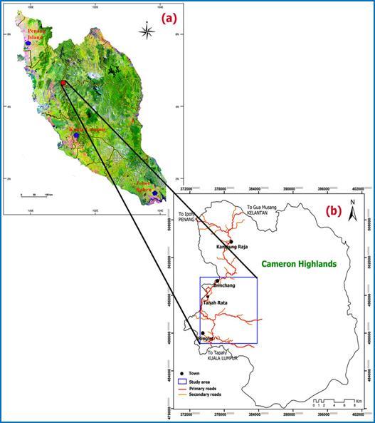
Table-1: SummaryofRainfallIntensity,Cumulative Rainfall,DurationandSWIofDebrisandMudFlowin CameronHighlands.
1.3 Rainfall Characteristics Related to Debris and Mudflow
2.Methodology
The rainfall characteristic in a rainfall series as shown in chart 1 that induces the debris and mud flow is considered the corresponding responsible rainfall. According to Basile & Panebianco [20], the cumulative rainfall is the predisposition and rainfall intensity are the triggering parameters that could initiate the occurrence. Thefrequencyofthedebris andmudflow occurrences by the monsoon distribution also investigated as it affected by the monsoon [21,22]. The guideline by the Ministry of Land, Infrastructure and Transport (MLIT), Japan determinedthatacontinuousrainfallmorethan80mmor a rainfall intensity more than 20mm hourly could induce thedebrisandmud flow[23]. Therainfall durationhasa closedcorrelationandthereforebeingapopularempirical model of Intensity Duration (ID) threshold. [3 5, 24 27]. Nikolopoulos et al. [28] suggested that the short duration considered as less than 12 hr shall be excluded in the analysistoimprovethebiasandimprovetheperformance of the ID relationship. As such, this study investigates the characteristics of the rainfall suchas short intensity (high intensity, short duration) or prolonged rainfall (low intensity, long duration) that induce the Debris and mud flowinCameronHighlands
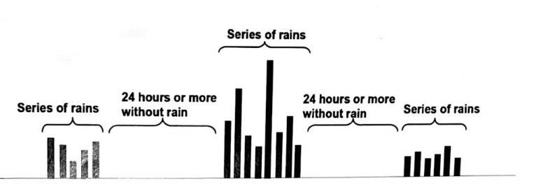
Chart1: Conceptof rainfallseries AccordingtoRahman&Mapjabil[29],otherfactors,other than rainfall, could have triggered the occurrence of landslides, such as earthquakes, volcanic activity, and human engineering activity. However, according to Kasim etal. [21],rainfall istheprimarycauseofdebrisandmud flow in Peninsular Malaysia. Therefore, the rainfall characteristic for the study area such as rainfall intensity, cumulative rainfall, duration and SWI are calculated and summarizedastablebelow;
International Research Journal of Engineering and Technology (IRJET) e ISSN: 2395 0056 Volume: 09 Issue: 02 | Feb 2022 www.irjet.net p ISSN: 2395 0072 © 2022, IRJET | Impact Factor value: 7.529 | ISO 9001:2008
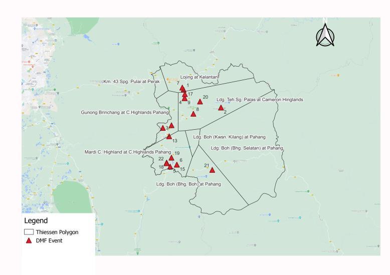
Thecollectionofthehistoricaldebrisandmudflowisfrom the various sources and compiled accordingly to the information required to perform the calculation of rainfall intensity, rainfall duration and cumulative rainfall that inducesthedebrisandmudflowinthisstudy.Onerainfall event or series in accordance with the guidelines for development of warning and evacuation systems against sediment related disasters, MLIT, Japan is defined as the startingandendingofrainwithnorainfallfor24hoursor over before the rain and after the rain. [23]. The rainfall intensity is the depth of rain during the event, while the FiguremudbasedThestationshownandusesrainMeanwhile,series.therainfalldurationisthetotaldurationoftherainfallseriesofevent.Cumulativerainfallisthetotalofraininthetherainfalldataforthisstudyismeasuredbyagaugeandispresentedinhourlyformat.Thisstudyall6numbersofexistingrainfallstationsnetworks,theThiessenPolygonmethodisusedinthisstudyasinFig.3.Thenearestrainfallstationisusediftheisnotavailableduringtheoccurrenceoftheevent.applicationofSWIinCameronHighlandsisestimatedonpreviousrecordsofrainfalldataanddebrisandfloweventsadoptingthetankmodelillustratesinbelow;
Certified Journal | Page1003
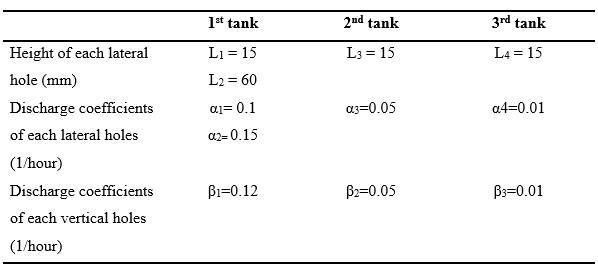
International Research Journal of Engineering and Technology (IRJET) e ISSN: 2395 0056 Volume: 09 Issue: 02 | Feb 2022 www.irjet.net p ISSN: 2395 0072 © 2022, IRJET | Impact Factor value: 7.529 | ISO 9001:2008 Certified Journal | Page1004 Fig 2: ThreeserialtankofTankModel Theequationadoptedforthisstudyisasbelow; SoilWaterIndex(SWI)=S1+S2+S3 (Equation Error! No text of stylespecified document.in 1) S1(t+Δt)=(1 β1・Δt) S1(t) [α1{S1(t) L1}+α2{S1(t) L2}]・Δt+R (Equation Error! No text of stylespecified document.in .2) S2(t+Δt)=(1 β2・Δt) S1(t) α3{S2(t) L3}・Δt+β1・S1(t)・Δt (Equation Error! No text of stylespecified document.in 3) S3(t+Δt)=(1 β3・Δt) S1(t) α4{S3(t) L4}・Δt+β2・S2(t)・Δt (Equation Error! No text of stylespecified document.in 4) where, S1,S2,S3 :Waterstorageineachtank(mm) α1,α2,α3,α4:Dischargecoefficientsofeachlateralholes(1/hr) β1,β2,β3 :Dischargecoefficientsofeachvertical holes(1/hr) L1,L2,L3 :Heightofeachlateralholes(mm) Δt1 :Steptime(1hour) R :Rainfall(Hourlyrainfall) The constant parameters of discharge coefficients and the height of each lateral holes uses the ones that were developed by Okada et al. [30]. Consequently, despite the diversegeologicalconditions,theJMAaccepteditfortheir early warning system for all of Japan. This was used in Taiwan to calculate their SWI for mass movement prediction tools Chen et al. [31] and large scale landslides Lin et al. [32] Okada et al. [30]. investigated fixed parameters with the accustomed parameters for different localities and found comparable drifts. Furthermore, the SWIindicatestheslope'sconceptualwatercontent.Table2showstheconstantparametersforeach layer ortankinequations2.1to2.4 Table 2: ParametersofSWI Fig 3:EventandtheThiessenPolygonoftheRainfallStation 3.Finding The debris and mud flow in Cameron Highlands occur frequently during the Northwest Monsoon (8 out of 20

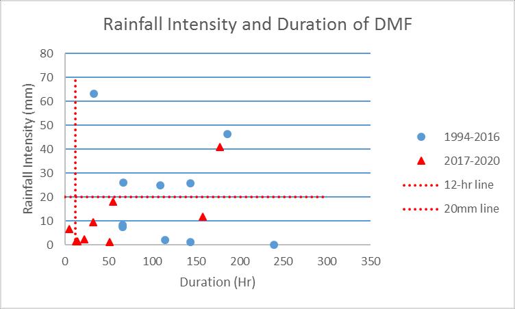
The finding in this study also suggested that debris and mud flow in the study area is potentially to happen more duringtheprolongedrainfallwhereby13events(65%)fall inthiscondition. Thisresultiscontrarytotheguidelineby MLIT Japan that only 6 events (30%) of rainfall intensity more than 20mm. However, 60% of the event shows cumulative rainfall more than 80mmas perguideline. The findingissummarisedinthechart 3andTable 4; Chart 3:RainfallIntensityandDurationofDebrisand MudFlow
Low intensity (<20mm), long duration (>12hrs) 13 High intensity (>20mm), long duration(>12hrs) 6 Low intensity(<20mm), Short duration(<12hrs) 1 High intensity(>20mm), Short duration(<12hrs) 0 4.CONCLUSIONS
The first historical ranking of SWI was 105 in 2015 followed by SWI in 2000, 104 and 1994, 103. The historical value of the SWI can be the benchmark of the debris and mud flow occurrences in the study area. The finding for the SWI value shows that the value has decreased in recent years This could be due to the rapid land opening for the agricultural activities or the failure occursatthesameslope
Thisstudyalsocanbeservedasthebasisofthethreshold establishment in the future study of SWI in Cameron Highlands other than its goal to contribute to the disaster management plan, as well as responsible agencies in conveyingthewarningtothelocalcommunity.
We would like to thank the Malaysian Public Service Department for the scholarship provided through the "Program Hadiah Latihan Persekutuan" (HLP), Sponsorship Offer for Professional and Managerial Officer to Pursue Master's and Doctoral Degree (Ph.D) Full Time, and the Department of Irrigation and Drainage (DID) for their policy to support this study. Special thanks to the DID's Water Resources Management and Hydrology Division, Facility Management and GIS Division, and Cameron Highlands Public Works Department (PWD) for providingalltheinputdatausedinthisstudy.
Month Mar Apr May Jun Jul Aug Sep Oct Nov Dec Jan Feb No.ofDMF 0 1 4 0 0 2 0 5 1 4 1 2 MonsoonTotal InterMonsoon 51 SouthwestMonsoon NortheastMonsoon 6 8 InterMonsoon
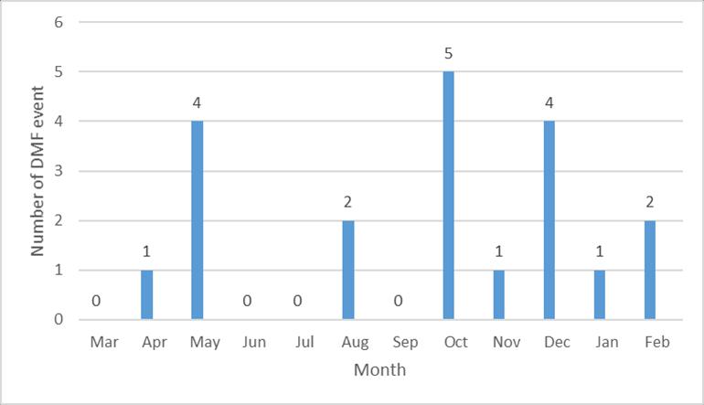
Table 3: FrequencyofDebrisandMudFlowOccurrence byMonsoon
International Research Journal of Engineering and Technology (IRJET) e ISSN: 2395 0056 Volume: 09 Issue: 02 | Feb 2022 www.irjet.net p ISSN: 2395 0072 © 2022, IRJET | Impact Factor value: 7.529 | ISO 9001:2008 Certified Journal | Page1005 events) followed by Southwest Monsoon (6 out of 20 events). Apparently, it occurs the most in October, May and December. The occurrence frequency by the month and monsoon distribution is shown in the Chart 2 and Table 3below; Chart 2:
While the SWI for Cameron Highlands is 61 on average.
Based on the findings of this study, it can be concluded that when rainfall conditions are low intensity and long duration there is a higher percentage of debris and mud flow occurrence than when rainfall conditions are high intensity and short duration. However, with a longer duration, the parameter's contribution to the event is significant to the intensity of the rainfall parameters. The debris and mud flow are likely to happen more in the study area when the cumulative rainfall is more than 80mmforthedurationoftheseriesmorethan24 hour.
ACKNOWLEDGEMENT
FrequencyofDebrisandMudFlowOccurrence byMonth
Table-4: SummaryoftherainfallconditionofDebrisand MudFlow Rainfallcondition Number of events
3) Caine N,” Rainfall intensity duration control of shallowlandslidesanddebrisflows,”GeografAnn. Vol.62,1980,pp.23 27,doi:10.2307/520449
11) Jamaludin S, Abdullah C.H, Kasim N, “Rainfall intensity and duration for debris flow triggering in Peninsular Malaysia,” Landslide Science for a SaferGeoenvironment,2014,pp.167 172.
14) Abidin M.R.Z, Dom N.M, “Debris and mudflow warning modeling: Case study of Cameron Highlands, Malaysia. Paper presented at Strategic Strengthening for South South Cooperation for Modelling and Managing Hydro Hazards”, 31 August 1September2015,Jakarta,Indonesia
15) Matlan S.J, Abdullah S, Alias R, Mukhlisin M, “Effectofworkingrainfallandsoilwaterindexon slope stability in Ranau, Sabah,” International Journal of Civil Engineering and Technology, vol. 9(7), 2018, pp. 1331 =IJCIET&VType=9&IType=7http://www.iaeme.com/IJCIET/issues.asp?JType1341.
10) Lee M.L, Ng K.Y, Huang Y.F, Li W.C, “Rainfall inducedlandslidesinHuluKelangarea,Malaysia,” Natural Hazards, vol. 70(1), 2014, pp. 353 375. doi:10.1007/s11069 013 0814 8
12) Kuraoka S, Mori M, “Examples of technology transfer projects for mitigation of debris flow in Peninsular Malaysia and landslides in El Salvador” Proceedings of Japan Landslide AssociationSymposium,2014,pp.1 24
13) Mukhlisin M, Matlan S.J, Ahlan M.J, Taha M.R, “Analysisofrainfall effect to slopestabilityinUlu Klang, Malaysia”, Jurnal Teknologi, 2015, vol. 72(3),pp.15 21,doi:10.11113/jt.v72.4005
4) Guzzetti F, Peruccacci S, Rossi M, Stark C.P,” The rainfall intensity duration control of shallow landslides and debris flows: an update,” Landslides, Vol.5(1), 2008, pp. 3 17, doi:10.1007/s10346 007 0112 1
9) JamaludinS,AliF,“Anoverviewofsomeempirical correlations between rainfall and shallow landslides and their applications in Malaysia,” Electronic Journal of Geotechnical Engineering, vol.16,2011,pp.1430 1440.
1) Dikau R., Brunsden D., Schorott L., Ibsen M. L., “Landslide recognition: Identification, movement and courses”, Report No 1 of the European Commission Environment Programme Contract NoEv5v CT94 0454,1 243,1996.
7) Keefer D.K, Wilson R.C, Mark R.K, Brabb E.E, BrownIIIW.M,EllenS.D,HarpE.L,WieczorekG.F, AlgerC.S,ZatkinR.S,“Real timelandslidewarning during heavy rainfall,” Science, vol. 238(4829), 1987,pp.921 925.Doi:10.1126/science.1143308
2) Varnes D.J, “Slope movement: Type and process. Landslides and Engineering Practice,” (Special Report 176). National Academy of Sciences, Washington,DC.1978
5) Wieczoreck G.F, “Effect of rainfall intensity and duration on debris flows in central Santa Cruz Mountains, California. In: J. E. Costa and G. F. Wieczorek (eds), debris flows/ avalanches: Process, Recognition and Mitigation” (Reviews in Engineering Geology No. 7, pp. 93 104), Geological Society of America, Boulder, CO. 1987 doi:10.1130/REG7
16) KasimN,TaibK.A,GhazaliN.A.A,AzaharW.N.A.W, Ismail N.N, Husain N.M, Ramli A.B, Saad S.A, Masjuki S.A, Ibrahim S.L, “Rainfall intensity (I) duration (D) induced debris flow occurrences in Peninsular Malaysia. Lecture Notes in Civil Engineering, 897 903, 2020, doi: 10.1007/978 3 030 32816 0_66
18) ‘Penghasilan peta bahaya dan risiko cerun (PBRC), Cameron Highlands’, Final Report, Department of Mineral and Geoscience, Malaysia, 2016 19) Sapuro, J. T, “Management of Cameron Highlands development activities and its impact to the environment,”Euphytica,vol.18(2),2016,pp. 1 11,doi:10.1016/j.jplph.2009.07.006.
REFERENCES
8) Dom N.M, Khan N, Yahya E.M, “Development and evaluation of debris and mudflow warning model in high risk hilly slopes in Malaysia,” Paper presented at National Conference on Water for Sustainable Development Towards a Developed Nation by 2020, 13 14 July 2006, Port Dickson, Malaysia
International Research Journal of Engineering and Technology (IRJET) e ISSN: 2395 0056 Volume: 09 Issue: 02 | Feb 2022 www.irjet.net p ISSN: 2395 0072 © 2022, IRJET | Impact Factor value: 7.529 | ISO 9001:2008 Certified Journal | Page1006
17) Maturidi A.M.A.M, Kasim N, Taib K.A, Azahar W.N.A.W, Tajuddin H.A, “Empirically based rainfall threshold for landslides occurrence in Cameron Highlands, Malaysia,” Civil Engineering and Architecture, 2020, vol. 8(6) pp. 1481 1490, doi:10.13189/cea.2020.080629
6) Chen C.Y, Fujita M, “An analysis of rainfall based warning systems for sediment disasters in Japan and Taiwan,” International Journal of Erosion Control Engineering, Vol. 6 2013, pp. 47 57, doi:10.13101/ijece.6.47
27) Maturidi, A. M., Kasim, N., Abu Taib, K., & Wan Azahar, W. N. A., “Rainfall Induced Landslide ThresholdsDevelopmentbyConsideringDifferent Rainfall Parameters: A Review,” Journal of Ecological Engineering, vol. 22(10),2021, pp.85 97,doi:10.12911/22998993/142183.
21) Kasim, N., Taib, K. A., Mukhlisin, M., & Kasa, A, “Triggering Mechanism and Characteristic of Debris Flow in Peninsular Malaysia,”American Journal of Enginering Research (AJER), vol. 5(4), 2016,pp.112 119 22) Winter, M. G., Dent, J., Macgregor, F., Dempsey, P., Motion, A., & Shackman, L, “Debris flow, rainfall and climate change in Scotland” Engineering Geology and Hydrogeology, vol. 43(4), 2010, pp. 429 446doi:10.1144/1470 9236/08 108
28) Nikolopoulos,E.I.,Crema,S.,Marchi,L.,Marra,F., Guzzetti, F., & Borga, M., “Geomorphology Impact of uncertainty in rainfall estimation on the identificationofrainfallthresholdsfordebrisflow occurrence,” vol. 221, 2014, pp. 286 297, doi: 10.1016/j.geomorph.2014.06.015
32) Lin,G.,Kuo,H.,Chen,C.,Wei,L.,&Zhang,J.“Using aTankModeltoDetermineHydro Meteorological Thresholds for Large Scale Landslides in Taiwan” MDPI, vol 12,253 2020, pp. 1 17, doi: 10.3390/w12010253.
25) Jakob, M., Owen, T., Simpson, T, “A regional real time debris flow warning system for the District of North Vancouver, Canada,” Landslides vol. 9, 2012, pp. 165 178, doi: 10.1007/s10346 011 0282 8. 26) Dahal R.K., Hasegawa S, “Representative rain fall thresholds for landslides in the Nepal Himalaya,” Geomorphology, vol. 100(3 4), 2008, pp. 429 443,doi:10.1016/j.geomorph.2008.01.014
20) Basile, G., & Panebianco, M, “Landslide Science andPractice”,Landslide ScienceandPractice, vol. 2, 2013, pp. 603 610, doi: 10.1007/978 3 642 31445 2
Page
23) Ministry of Land, Infrastructure and Transport, J. “Guidelines for development of warning and evacuation system against sediment related disasters,”September2003.
29) Rahman, H. A., & Mapjabil, J., “Landslide Disaster in Malaysia: An Overview,” Health and the EnvironmentJournal, vol. 8(1),.2017,pp. 58 71 doi:10.24940/ijird/2019/v8/i6/jun19058
24) Aleotti, P., “A warning system for rainfall induced shallow failures,” Eng. Geol. 73, 2004, pp. 247 265,doi:10.1016/j.enggeo.2004.01.007
International Research Journal of Engineering and Technology (IRJET) e ISSN: 2395 0056 Volume: 09 Issue: 02 | Feb 2022 www.irjet.net p ISSN: 2395 0072 © 2022, IRJET | Impact Factor value: 7.529 | ISO 9001:2008 Certified Journal | 1007
30) Okada, K., Makihara, Y., Shimpo, A., Nagata, K., Kunitsugu, M., and K. Saith, K, “Soil Water Index”, Tenki,vol48.5,2001,pp.59 66. 31) Chen, C., Saito, H., & Oguchi, T. , “Analyzing rainfall inducedmassmovementsinTaiwanusing the soil water index” Landslides, 2017, doi:10.1007/s10346 016 0788 1