International Research Journal of Engineering and Technology (IRJET) e-ISSN: 2395-0056

Volume: 09 Issue: 12 | Dec 2022 www.irjet.net p-ISSN: 2395-0072
International Research Journal of Engineering and Technology (IRJET) e-ISSN: 2395-0056
Volume: 09 Issue: 12 | Dec 2022 www.irjet.net p-ISSN: 2395-0072
Syed Farzana1 , Kanakam Sasikalyan2 , Jasti Manikanta3, Kommalapati Manoj4, Choppara Prasanth5
1Assistant Professor, Department of Computer Science, KKR& KSR Institute of Technology and Sciences(A), Guntur, Andhra Pradesh, India 2,3,4,5Undergraduate Students (B. Tech), Department of Computer Science, KKR& KSR Institute of Technology and Sciences(A). Guntur, Andhra Pradesh, India ***
Abstract - In tertiary hospitals, understaffing and overcrowding are directly related to a lack of available hospital beds. The issue for certain tertiary healthcare facilities is not just a lack of available inpatientbedspaces,but also a lack of qualified healthcare professionals, such as physicians and nurses, who are unable to treat more patients than the facility is equipped to handle. The public and health officials have expressedalarmingconcernabouttheCOVID-19 worldwide pandemic. The primary issue that many nations encounter during the epidemic is a lack of medical resources.
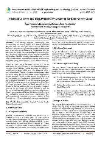
Nowadays, there are a lot more patients, thus in an emergency, they must be taken as quickly as possible to the hospital where they can receive treatment. The need for ambulances increased along with the noticeably higher patient population.Therearethousandsofambulanceservices operating today, serving unidentified persons. Finding the nearest ambulance inthat locationbecomesverydifficultfora person. We developed a piecewise smooth model to describe the constraint of hospital beds in order to analyze how a lack of hospital beds affected the Emergency outbreak. Using GPS, the closest hospitals are found, and Google Map APIs can then be used to find the path from the current position. A patient can use this to discover the closest hospital as well as infrastructure like available beds, specialist consultants, etc. To deliver services using PHP andSQL databasesastheserver, the application uses a client-server architecture. The technology can be integrated in ambulance services to find hospitals more efficiently, especially in emergency situations.
Key Words: Bed Availability, Hospital, Patients, Google MapsAPIs,Ambulance
Hospital bed occupancy prediction and optimization, or capacity planning, is a growing field. The objective is to optimizebusinessoperationsandboostproductivityinthe healthcaresector.Asahospitalinoneoftheworld'slargest cities,youmaybeawareofthehospitalshortage.Sincethese circumstancesaresoirritating,forecastingthebedoccupancy in advance and then using those predictions to optimize
patientplacementisanintriguingandrelevanttopic.Italso predictsthebedavailabilityduringthefollowing72hours.
To get the information about the occupancy of beds and necessary items for the patients especially in emergency cases,aclient-serverapplicationmustbeboughtintousage toidentifythemtomakeawareofpatientsandmakethem easytofind.
The main theme of Hospital Locator and Bed Availability detector for emergency cases is to develop a webservices basedsystemtoprovideoptimalservicesfortheemergency casesthroughthefollowingobjectives:
a) Provideaapplicationthatusercaneasilyinteractwith it and provide all the information the hospitals infrastructureanddoctorsavailability.
b) Findingtheoptimalroutesofclosesthospitalsusing GoogleMapsAPIs.
c) Withthissystemwecanreducethenumberofdeaths during emergency situations, hospitals with bed, specialist consultants’ availability through the applicationservice.
The Project locates hospitals in pandemic scenarios in a unique way, especially in emergency cases. Based on the minimaldistance,hospitalrequirements,andinfrastructure, searchforandsorttheresults.Todiscovernearbyhospitals and the distance between patients' locations and those hospitals,weareusingGoogleMapsAPIsinthiscase.The applicationincludesfastaccesstoalistofspecialists'contact informationaswellascomprehensivehospitaldataforeach hospital,makingitidealformakingsame-dayappointments. The future potential of this application is to create a realtimenetworkofnearbyspecialistswhoareavailabletotreat patients.Additionally,thisbreakthroughwillallowforthe bookingofonlineappointments,whichbenefitspatientsby
International Research Journal of Engineering and Technology (IRJET) e-ISSN: 2395-0056
Volume: 09 Issue: 12 | Dec 2022 www.irjet.net p-ISSN: 2395-0072
savingthemtime.Hospitaladministrationmakesadvantage ofthefunctionalhealth-caresoftwarenowinuse.Asstated in the methodology section above, we can create an application to find all pertinent information about the hospital. To give services to patients/people hurt in accidentsorotheremergencyinstances,thesystemcanbe connectedontotheambulanceplatform.
This web-based system mainly works over the internet connection. With the help of the Google Map Application ProgramInterface,theclosesthospitalscanbefoundusing GPS,andfromthere,thepathmaybetaken.Itisnecessaryto have a strong internet connection; else, the application wouldyieldpoorresults.
BackgroundPlanningduringepidemics,suchtheCOVID19 pandemic,requiresanaccurateestimationofthenumberof beds required by ward type (such as ICU). Ten-day projectionson the required numberof bedsforCOVID-19 patientsacrossvariouswardswereusedbytheCOVID-19 taskforceattheGhentUniversityhospital.Theplanningtool integrated a Poisson model for the daily number of new admissions with a multistate model for the movement of admitted patients to different wards, discharge, or death. Therequirednumberofbedsbywardtypefortheupcoming 10 days, as well as the worst- and best-case boundaries, were simulated using these models. Results The models successfully predicted the needed number of beds for varioushospital wards. Predictions made in the shortrun wereparticularlyaccuratebecausetheyarelessvulnerable tounexpectedchangesinthenumberofbedsonaparticular ward Codesnippetsandsetupinformationaresuppliedto letthereaderapplytheplanningtooltotheirownhospital data.ConclusionsWithanaccurateforecastoftherequired capacity by ward type, we were able to quickly set up a planning tool that would be useful during the COVID 19 epidemic.Otherepidemicscanusethismethodologyaswell.
Short-termhospitalbedavailabilityforecastinghasproven to be a challenging problem, but computer modelling and artificial neural networks have proven to be an excellent solution.a computerbasedtosimulatethenon-stationary arrivals, different patient kinds, and general complexity found in hospital systems, simulation models have been developed. For the data that were available on bed usage, patient type prevalence, and patient lengths of stay, that modelwasvalid.
Twoarrivalscheduleswereusedinthesimulationtomimic patient arrivals: one was for elective (non-emergency) patients,andtheotherwasforemergencypatients.Dueto the distinct arrival patterns of emergency and elective patients, two streams of arrivals were selected. As actual
hourly arrival data were not available for empirical trend determination, these arrival trends of each stream of patientsanditsbreakdownthroughouteachdayoftheweek weredeterminedbasedontalkswithspecialists.Inorderto makethemixofpatientarrivalsreflectiveofwhatatypical hospital may encounter, these percentages were then adjusted to take into account all the patient kinds that weren't included in the model. Our objective has been to forecasttheavailabilityofbedsduringthenext72hoursor oneachday.Hence, thefuturebedavailabilitycanenhance theoperationprocessandimproveefficiencyinthehealthcareindustryforemergencysituations.
Anautomatedsystemmustbeimplementedtoidentifythem, tomakethepatientsawareofthem,andtomakethemsimple to find in order to obtain information regarding the occupancyofbedsandessential materialsforthepatients, particularly in emergency situations. to learn about bed occupancy and the supplies that patients, especially in an emergency, need. Find hospitals that are closer to the patient's location by using Google Maps APIs. Locate the hospitalwiththefewesttraveldistanceandthemostbeds available.Findanotherminimumlocationinthelistprovided bythesystemifthehospitalwithintheminimumdistance doesnothaveanybeds.Tomaketheuser'ssearchsimple, the hospitals are listed according to the necessary departments and services. Instead of forcing patients to switchhospitalsin orderto receive the essential care and services, we provide the relevant information about all hospitalsdirectlyfromtheapplications.Thisprojecthastwo differentapplicationkinds.Theapplication'sadministrator adds all the information regarding the cities, regions, hospitals, illnesses, symptoms, departments, and various servicesthatareoffered.Inordertoenjoyalltheservices, usersorpatientsmustregisterwiththeapplication.Users can browse the hospitals and services offered, as well as search using terms related to cities, hospitals, and departments. The suggested application is a very varied application that registered users of the application can accesswith ease. TheGPSfeatureallowsuserstofind the closest hospitals. The programme retrieves the closest hospitals based on the user's current location and gives informationaboutthehospitalsandtheirofferings.Patients can choose a hospital based on the results and users can accessthehospital'sroutemapbasedontheresultsaswell.
Thispaperintroducesareadilyaccessibleapplicationthat uses Google Maps to show users other hospital users' assessments ofhospitalsaswell asroutes,directions,and traffic updates. The suggested system also includes automaticnavigationfunctions,suchasshowingusersthe best route to take from their current location to their destinationandcalculatingthedistance-baseddrivingtime. Inordertoprovidesolutions,thissystemhasbeencreated andusesPHP,JSON,MySQL,GoogleMapsAPIs,andGoogle
2022, IRJET | Impact Factor value: 7.529 | ISO 9001:2008 Certified Journal | Page827
International Research Journal of Engineering and Technology (IRJET) e-ISSN: 2395-0056
Volume: 09 Issue: 12 | Dec 2022 www.irjet.net p-ISSN: 2395-0072
Direction APIs. Users act as the client in this application's client/serverdesign,whilePHPandaMySQLdatabaseactas theserver.
Theapplicationprogramminginterfaces(APIs)forGoogle Maps are a collection that enable communication with its services.FortheWeb,iOS,andAndroid,itwillenableusto createlocation-basedappsthatrangefrombeingreallybasic to extremely complex. An online mapping tool and technologyofferedbyGoogleiscalledMaps.Thesoftware offers in-depth details on geographical areas, sites, street maps, a route planner for driving and walking, as well as aerial and satellite views of countless locations in many differentnationsaroundtheworld.Youhavethepowerto designuniquemapsthankstotheGoogleMapsAPI.
Before accessing any Google Maps API Services, you must firstobtainanAPIKeyfromGoogleCloudPlatform.
MakingAnAPIKey
Activatebilling
ProtectyourlibrariesandAPIkey.
Various APIs are available through the Google Map APIs thoseare: Places API,DistanceMatrixAPI,DirectionsAPI, andGeofencingAPIareallincluded.
Simulationisapreferredmethodforlearningaboutcomplex, inter-related systems, and as such, a valid and accurate computersimulationmodeliscapableofproducingreliable predictionsoffutureperformanceofthosesystems.While discussionofcomputersimulationanexampleapplicationof computer simulation shows its ability to capture the behavior of whole systems. Bagust, Place, and Posnett (1999)studyhospitalbedusageandtheeffectofemergency admissions on the system, through the use of computer simulation.Bymodelingawholehospitalandenablingthe trackingofvariousmeasuresofinterest,theauthorsareable to reach significant conclusions regarding the availability andusageofbeds:specifically,thatwhenthehospitalinthis studywasmorethan85%occupied,theriskofrunningout ofavailablebedsbecamesignificant,withlong-termimpact. "Even a relatively low risk of failure can disrupt the
operationofahospitalforaconsiderabletime:at85%mean occupancy,ahospitalthatrunsoutofbedsforfourdaysina year may be disrupted for up to eight weeks in total" (p. 157).Thisexampledemonstratesthetypeoflarger-context analysis that can make simulation models powerful for forecasting.Simulationasaforecastingmethod,however,is not without its drawbacks. The drawback associated with computersimulationisthat,likethestatisticalmodelsabove, it must be manually adjusted to some degree as the real systemchanges. Fromthereviewofliteraturethusfar,itis apparent that simple, static methods which dynamically predictandgeneratetheshort-termhospitalbedavailability innext72hours.
Anonlineapplicationmustbeusedtoidentifythepatients andmakethemeasytofindinordertoobtaininformation regarding the occupancy of beds and the products the patientsneed.Themaingoalofthisprojectistodevelopa GPSsysteminwhichanambulanceisequippedwithaGPS tracker.Inthisway,eventhegeneralpublicmaykeeptrack ofallambulancesnearbyand,inanemergency,wecancall the closest ambulance to the patient's position. This will enable time savings. By determining the shortest path method, GPS technology is used in this system to enable patients get at the hospital in the lowest amount of time possible.
[1] Geetha,Selvaraj,SamayanNarayanamoorthy,Thangaraj Manirathinam, and Daekook Kang. "Fuzzy case-based reasoning approach for finding COVID-19 patients priorityinhospitalsatsourceshortageperiod."Expert SystemswithApplications178(2021):114997.
[2] Ravaghi,H.,Alidoost,S.,Mannion,R.andBélorgeot,V.D., 2020.Modelsandmethodsfordeterminingtheoptimal numberofbedsinhospitalsandregions:asystematic scoping review. BMC health services research, 20(1), pp.1-13.
[3] Kittipanya-Ngam,Panachit,OngSohGuat,andEngHow Lung."Beddetectionformonitoringsysteminhospital wards." 2012 Annual International Conference of the IEEEEngineeringinMedicineandBiologySociety.IEEE, 2012.
[4] McClean,Sally,andPeterH.Millard."Adecisionsupport system for bed-occupancy management and planning hospitals." Mathematical Medicine and Biology: A JournaloftheIMA12,no.3-4(1995):249-257.
[5] Junafan, Achmad. "Geographic Information System Locating Hospitals and Police Stations Based on Android."JournalofIntelligentDecisionSupportSystem (IDSS)4,no.2(2021):41-46.
International Research Journal of Engineering and Technology (IRJET) e-ISSN: 2395-0056
Volume: 09 Issue: 12 | Dec 2022 www.irjet.net p-ISSN: 2395-0072
[6] Waskito, A. A., Arifin, A., & Nuh, M. (2022, July). OptimizationofEmergencyDepartmentBedAvailabilty using Patient Detection System. In 2022 International SeminaronIntelligentTechnologyandItsApplications (ISITIA)(pp.48-51).IEEE.
[7] Inoue,M.,Taguchi,R.andUmezaki,T.,2018,July.Visionbased bed detection for hospital patient monitoring system.In201840thAnnualInternationalConference oftheIEEEEngineeringinMedicineandBiologySociety (EMBC)(pp.5006-5009).IEEE.
[8] Pecoraro, F., Luzi, D. and Clemente, F., 2021. The efficiencyintheordinaryhospitalbedmanagement:A comparativeanalysisinfourEuropeancountriesbefore theCOVID-19outbreak.Plosone,16(3),p.e0248867
2022, IRJET | Impact Factor value: 7.529 | ISO 9001:2008 Certified Journal