International Research Journal of Engineering and Technology (IRJET)
e-ISSN: 2395-0056
Volume: 08 Issue: 08 | Aug 2021
p-ISSN: 2395-0072
www.irjet.net
Fidelity of AI Model in Representing the Different Types of Cyclone Track Estimation Smruti Vyavahare1, Dr. H.K.Khanuja2 1Student,
Dept. of Technology, SPPU, Maharashtra, India of Dept., Dept. of Computer Engineering, MMCOE, Pune, Maharashtra, India ---------------------------------------------------------------------***---------------------------------------------------------------------2Head
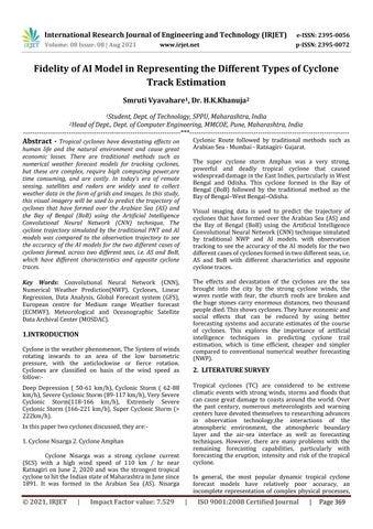
Cyclonic Route followed by traditional methods such as Arabian Sea - Mumbai - Ratnagiri- Gujarat.
Abstract - Tropical cyclones have devastating effects on human life and the natural environment and cause great economic losses. There are traditional methods such as numerical weather forecast models for tracking cyclones, but these are complex, require high computing power,are time consuming, and are costly. In today’s era of remote sensing, satellites and radars are widely used to collect weather data in the form of grids and images. In this study, this visual imagery will be used to predict the trajectory of cyclones that have formed over the Arabian Sea (AS) and the Bay of Bengal (BoB) using the Artificial Intelligence Convolutional Neural Network (CNN) technique. The cyclone trajectory simulated by the traditional PNT and AI models was compared to the observation trajectory to see the accuracy of the AI models for the two different cases of cyclones formed. across two different seas, i.e. AS and BoB, which have different characteristics and opposite cyclone traces.
The super cyclone storm Amphan was a very strong, powerful and deadly tropical cyclone that caused widespread damage in the East Indies, particularly in West Bengal and Odisha. This cyclone formed in the Bay of Bengal (BoB) followed by the traditional method as the Bay of Bengal–West Bengal–Odisha. Visual imaging data is used to predict the trajectory of cyclones that have formed over the Arabian Sea (AS) and the Bay of Bengal (BoB) using the Artificial Intelligence Convolutional Neural Network (CNN) technique simulated by traditional NWP and AI models. with observation tracking to see the accuracy of the AI models for the two different cases of cyclones formed in two different seas, i.e. AS and BoB with different characteristics and opposite cyclone traces. The effects and devastation of the cyclones are the sea brought into the city by the strong cyclone winds, the waves rustle with fear, the church roofs are broken and the huge stones carry enormous distances, two thousand people died. This shows cyclones. They have economic and social effects that can be reduced by using better forecasting systems and accurate estimates of the course of cyclones. This explores the importance of artificial intelligence techniques in predicting cyclone trail estimation, which is time efficient, cheaper and simpler compared to conventional numerical weather forecasting (NWP).
Key Words: Convolutional Neural Network (CNN), Numerical Weather Prediction(NWP), Cyclones, Linear Regression, Data Analysis, Global Forecast system (GFS), European centre for Medium range Weather forecast (ECMWF), Meteorological and Oceanographic Satellite Data Archival Center (MOSDAC).
1.INTRODUCTION Cyclone is the weather phenomenon, The System of winds rotating inwards to an area of the low barometric pressure, with the anticlockwise or fierce rotation. Cyclones are classified on basis of the wind speed as follow:-
2. LITERATURE SURVEY Tropical cyclones (TC) are considered to be extreme climatic events with strong winds, storms and floods that can cause great damage to coasts around the world. Over the past century, numerous meteorologists and warning centers have devoted themselves to researching advances in observation technology,the interactions of the atmospheric environment, the atmospheric boundary layer and the air-sea interface as well as forecasting techniques. However, there are many problems with the remaining forecasting capabilities, particularly with forecasting the eruption, intensity and risk of the tropical cyclone.
Deep Depression ( 50-61 km/h), Cyclonic Storm ( 62-88 km/h), Severe Cyclonic Storm (89-117 km/h), Very Severe Cyclonic Storm(118-166 km/h), Extremely Severe Cyclonic Storm (166-221 km/h), Super Cyclonic Storm (> 222km/h). In this paper two cyclones discussed, they are:1. Cyclone Nisarga 2. Cyclone Amphan Cyclone Nisarga was a strong cyclone current (SCS) with a high wind speed of 110 km / hr near Ratnagiri on June 2, 2020 and was the strongest tropical cyclone to hit the Indian state of Maharashtra in June since 1891. It was formed in the Arabian Sea (AS). Nisarga
© 2021, IRJET
|
Impact Factor value: 7.529
In general, the most popular dynamic tropical cyclone forecast models have relatively poor accuracy, an incomplete representation of complex physical processes,
|
ISO 9001:2008 Certified Journal
|
Page 369