International Research Journal of Engineering and Technology (IRJET)
e-ISSN: 2395-0056
Volume: 08 Issue: 07 | July 2021
p-ISSN: 2395-0072
www.irjet.net
Temporal Mapping and Monitoring of Migratory Behaviour of Kali River Using Remote Sensing and GIS Technology Somendra Singh1, Ram Chandra2, Sudhakar Shukla3 ¹M. Tech Student, Remote Sensing Applications Centre Uttar Pradesh, India ²Head &Scientist-E, Geospatial Data Division, Remote Sensing Applications Centre Uttar Pradesh, India ³Head &Scientist-E, School of Geoinformatics, Remote Sensing Applications Centre Uttar Pradesh, India ---------------------------------------------------------------------***---------------------------------------------------------------------
Abstract - Rivers are lifeline of the planet earth. It has been seen that ancient civilizations were developed along the river but in the current scenario most of the development is being done along the roads or highways but still depends on river. Rivers changes its course over time due to sediment load, erosion activity and huge amount of water. In the present investigation river channels have been digitized in different years for temporal mapping and monitoring by overlaying the layers which results in identifying the pattern of changing course of Kali River with the help of multidate satellite data using GIS software and places have been identified which have drastic migration of river channel. After identifying places, ground verification has been carried out. Results describe where is migration have maximum and minimum and its impact on land use, settlement and agricultural land. Key Words: Temporal changes, Migration, Multidate satellite data, GIS.
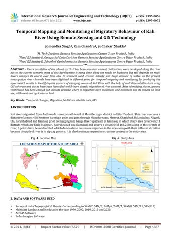
1.INTRODUCTION Kali river originated from Anthawada town Jansath tehsil of Muzaffernagar district in Uttar Pradesh. This river ventures a distance of almost 498 Km from its origin point and goes through Muzaffarnagar, Meerut, Ghaziabad, Bulandsahar, Aligarh, Eta, Farukhabbad and Kannauj prior to merging into Ganga River upstream of Kannuaj, in which study area covers only 4 districts which are Etah, Mainpuri, Farrukhabad and Kannauaj and covers a distance of 168.2 Km along in this stretch of river, 5 points have been identified which demonstrate maximum migration in the area alongwith their different direction because the path of river is in zig-zag pattern. It is also known as serpentine structure present in the study area. Fig -1: Location Map
Fig -2: Study Area
2. DATA AND SOFTWARE USED
Survey of India Topographical Sheets: Corresponding to 54M/2, 54M/3, 54M/6, 54M/7, 54M/8, 54M/11, 54M/12) Multidate Landsat satellite data for the year 1990, 2000, 2010, 2015 and 2020. Arc GIS Software Erdas Imagine Software
© 2021, IRJET
|
Impact Factor value: 7.529
|
ISO 9001:2008 Certified Journal
|
Page 4387