International Research Journal of Engineering and Technology (IRJET)
e-ISSN: 2395-0056
Volume: 08 Issue: 07 | July 2021
p-ISSN: 2395-0072
www.irjet.net
Flood Mapping of Aranmula Panchayat, Pathanamthitta using ArcGIS Reshma Rajendran B.1, Arjun V.Nath2, Feba Anna Reji3, Jeffin Jose4, Nicey Merin Mathew5 1Assistant
professor, 2,3,4,5B. Tech Graduate, Dept. of Civil engineering, Providence College of Engineering, Chengannur, Kerala, India ---------------------------------------------------------------------***----------------------------------------------------------------------
ArcGIS 10.4 is used to produce data visualizations in the form of a map with various disciplines and tools [1-4]. Flood map of Aranmula Panchayat has been obtained by using Digital Elevation Model (DEM) which is the primary input to the software. These maps could be used for emergency actions during flood as well as for future development of the community.
Abstract - Flooding is a transient condition where water
overflows and accumulates from inland or tidal or rapid runoff due to rain. Kerala has witnessed a fatal flood during August 2018, after the dreadful flood that occurred a century ago. The river basins were overflown due to the persisted rainfall and the low-lying areas turned submerged which caused damage to the lives and properties of many. As per IMD (Indian Meteorological Department) data, from 1st June 2018 to 19th August 2018, Kerala received a rainfall of about 2346.6mm which was 42% above the expected value. Aranmula Panchayat in Pathanamthitta district has been chosen as the study area as it was the most affected area in the year 2018, moreover, the area has only very few post flood studies. If proper planning had been taken prior to the flood, many lives could have been saved. Furthermore, a flood map would help to predict the impact of flood and take necessary actions accordingly. The present study used the Geographical Information System (GIS) in which a simple and cost-effective method has been deployed by incorporating Digital Elevation Model (DEM) and cumulative water levels. By examining the map generated, flood prone areas can be identified and proper planning and development works can be suggested to the authorities hence reduce the impacts of future flood.
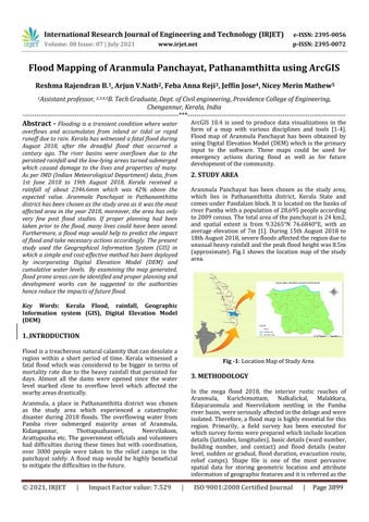
2. STUDY AREA Aranmula Panchayat has been chosen as the study area, which lies in Pathanamthitta district, Kerala State and comes under Pandalam block. It is located on the banks of river Pamba with a population of 28,695 people according to 2009 census. The total area of the panchayat is 24 km2, and spatial extent is from 9.3265°N 76.6840°E, with an average elevation of 7m [1]. During 15th August 2018 to 18th August 2018, severe floods affected the region due to unusual heavy rainfall and the peak flood height was 8.5m (approximate). Fig.1 shows the location map of the study area.
Key Words: Kerala Flood, rainfall, Geographic Information system (GIS), Digital Elevation Model (DEM)
1. INTRODUCTION Flood is a treacherous natural calamity that can desolate a region within a short period of time. Kerala witnessed a fatal flood which was considered to be bigger in terms of mortality rate due to the heavy rainfall that persisted for days. Almost all the dams were opened since the water level marked close to overflow level which affected the nearby areas drastically.
Fig -1: Location Map of Study Area
3. METHODOLOGY In the mega flood 2018, the interior rustic reaches of Aranmula, Kurichimuttam, Nalkalickal, Malakkara, Edayaranmula and Neervilakom nestling in the Pamba river basin, were seriously affected in the deluge and were isolated. Therefore, a flood map is highly essential for this region. Primarily, a field survey has been executed for which survey forms were prepared which include location details (latitudes, longitudes), basic details (ward number, building number, and contact) and flood details (water level, sudden or gradual, flood duration, evacuation route, relief camps). Shape file is one of the most pervasive spatial data for storing geometric location and attribute information of geographic features and it is referred as the
Aranmula, a place in Pathanamthitta district was chosen as the study area which experienced a catastrophic disaster during 2018 floods. The overflowing water from Pamba river submerged majority areas of Aranmula, Kidangannur, Thottapuzhasseri, Neervilakom, Arattupuzha etc. The government officials and volunteers had difficulties during these times but with coordination, over 3000 people were taken to the relief camps in the panchayat safely. A flood map would be highly beneficial to mitigate the difficulties in the future.
© 2021, IRJET
|
Impact Factor value: 7.529
|
ISO 9001:2008 Certified Journal
|
Page 3899