International Research Journal of Engineering and Technology (IRJET)
e-ISSN: 2395-0056
Volume: 08 Issue: 07 | July 2021
p-ISSN: 2395-0072
www.irjet.net
WILDLIFE HABITAT SUITABILITY ANALYSIS USING ANALYTIC HIERARCHY PROCESS AND GEOSPATIAL TECHNIQUES Babita Singh1, P. Kunwar2 1Remote
Sensing Applications Center, Lucknow-226021, Uttar Pradesh, India Remote Sensing Applications Center, Lucknow-226021, Uttar Pradesh, India ---------------------------------------------------------------------***--------------------------------------------------------------------2Scientist-SF,
Abstract – Conservation of wildlife species is done by
Therefore, geospatial techniques were used to identify suitable habitat for the common leopard in three districts of Uttarakhand state.
evaluating suitable habitat using geospatial techniques. The habitat suitability analysis for the common leopard (Panthera Pardus) was conducted in three districts of Uttarakhand StateDehradun, Haridwar, Pauri Garhwal. Prediction of potential suitable habitat for common leopard was done by integrating geospatial techniques with Analytic Hierarchy Process (AHP), an expert opinion-based model. The input parameters for this model were generated using SRTM-DEM and Landsat 8 satellite image for the year 2020. The thematic layers used were land use/cover (LULC), Normalized Difference Vegetation Index (NDVI), slope, aspect, distance from stream, road and settlement. The result from AHP model revealed that out of total area 29.73% area was very low suitable, and 25 % area was highly suitable. Very low suitable area was dominated by agriculture and built-up. The most influential parameters according to expert were land use/cover (35 %), NDVI (24 %) and distance from stream (16 %).
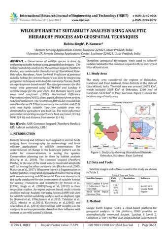
1.1 Study Area The study area considered the regions of Dehradun, Haridwar and Pauri Garhwal, three districts in the state of Uttarakhand, India. The total area was around 10678 Km², which included 3088 Km² of Dehradun, 2360 Km² of Haridwar, 5230 km² of Pauri Garhwal. Figure 1 shows the location map of study area.
Key Words: AHP, Common leopard (Panthera Pardus), GIS, habitat suitability, LULC 1.INTRODUCTION Remote Sensing and GIS have been applied in several fields ranging from oceanography to meteorology and from military applications to wildlife conservation. The determination of change in the landscape pattern can be useful for conservationists in saving the species. Conservation planning can be done by habitat analysis (Charry et al., 2018). The common leopard (Panthera Pardus) is the one of the most widely found and adaptable wild cat among the other carnivore cats (Marker et al.,2005; Maharjan et al., 2017). Whenever there is a fragmentation in habitat patches, integrated approach of multi criteria along with remote sensing and GIS is useful. This was showed as in the study conducted for the assessment of suitable habitat for sambar, rhinoceros and waterbirds by Porwal et al., (1996), Singh et al., (2009),Dong et al., (2013) in their respective studies. An expert opinion based multi criteria decision making- Analytic Hierarchy Process (AHP) was used for wildlife habitat suitability analysis such as elephant, tiger by (Porwal et al., 1996;Sanare et al.,2015; Talukdar et al., 2020; Mandal et al.,2021). Kushwaha et al.,(2002) and Areendran et al., (2011) showed that AHP weights can be assigned to various parameters based on their influence with context to the wild animal’s habitat.
© 2021, IRJET
|
Impact Factor value: 7.529
Figure 1: Study area showing Uttarakhand DistrictsDehradun, Haridwar, Pauri Garhwal
1.2 Data and Tools Satellite images and software used in this study are shown in Table 1. Satellite Images USGS Landsat 8 Level 2, Collection 2, Tier 1Year 2020 NASA SRTM Digital Elevation 30m
Table 1 Data and Tools Path / Resolution Row 145 / 039, 146 / 039
Software ArcGIS 10.5, Google Earth Engine
30 m
2. Method Google Earth Engine (GEE), a cloud-based platform for geospatial analysis. In this platform, USGS provides an atmospherically corrected dataset. Landsat 8 Level 2, Collection 2, Tier 1 for the year 2020(Landsat Collections in
|
ISO 9001:2008 Certified Journal
|
Page 3632