International Research Journal of Engineering and Technology (IRJET)
e-ISSN: 2395-0056
Volume: 08 Issue: 07 | July 2021
p-ISSN: 2395-0072
www.irjet.net
FLOOD HAZARD MAPPING IN RANNI TALUK, PATHANAMTHITTA Veni Gayathri1, Sangeetha Sanal2, Shahana Shaji3, Fathima Shajahan4 1-3Student,
Civil Engineering Department, Musaliar College of Engineering & Technology, Pathanamthitta, India Professor, Civil Engineering Department, Musaliar College of Engineering & Technology, Pathanamthitta, India ---------------------------------------------------------------------***---------------------------------------------------------------------4Assistant
Abstract - The heavy rainfall that occurred in Kerala in the years 2018 & 2019 flooded the entire state as well as Ranni causing intense damage to our lives and properties. By providing flood inundation maps, can reduce impacts that occurred tremendously. Ranni is the area taken for mapping using ArcGIS & GIS methods. Ranni is the biggest block of Tiruvalla division with an area of 1004.6 sq.km. Inundation maps can show the susceptible area & the vulnerable zones. Key Words: Susceptibility, Vulnerability, Mapping, NDVI, TWI, ArcGIS, GIS
1.INTRODUCTION Flooding is major natural disaster. Flood has tremendously put an impact on the study area, Ranni. By providing flood inundation maps we can find the low-lying areas with built up lands. Mapping gives management communication, Response, mitigation at the time of disaster. Billions of dollars in infrastructure, property and life damages and hundreds of human lives are lost each year. Thus, these can be prevented and reduced by providing reliable information to the public about the flood risk through inundation maps.
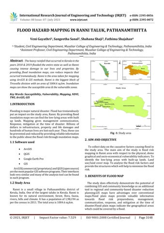
Fig -1: Study area
2. AIM AND OBJECTIVE
1.1 Software used
ArcGIS
QGIS
Google Earth Pro
GIS
To collect data on the causative factors causing flood in the study area. The main aim of the study is flood risk mapping in Ranni area with respect to the physical, demo graphical and socio-economical vulnerability indicators. To identify the low-lying areas with built-up lands. Land use/land cover map. To analyze the flood risk factors and provide the structures which will help to minimize the flood risk.
ArcGIS(commercial/proprietary) and QGIS (open source) are the most popular GIS software programs. Their interfaces look very similar and many of the analysis tool can be found in each program.
3. BENEFITS OF FLOOD MAP
1.2 Study Area
The study does effectively demonstrate the potential of combining GIS and community knowledge as an additional tool in regional and community-based disaster reduction planning.GIS maps have advantages over conventional maps.Flood plain maps provide valuable information towards flood risk preparedness, management, communication, response, and mitigation at the time of disaster.Flood plain maps indicate the geographical areas which could be covered by a flood.
Ranni is a small village in Pathanamthitta district of Kerala, India. One of the largest taluks in Kerala. Ranni is known for its natural environment, forest, flora, fauna, rivers, hills and climate. It has a population of 1,98,194 as per the census in 2011. The total area is 1004.6 sq.km.
© 2021, IRJET
|
Impact Factor value: 7.529
|
ISO 9001:2008 Certified Journal
|
Page 3148