International Research Journal of Engineering and Technology (IRJET)
e-ISSN: 2395-0056
Volume: 08 Issue: 07 | July 2021
p-ISSN: 2395-0072
www.irjet.net
Ground Water Quality Assessment of a Contaminated Site in Kerala Anju S1, Arya Presannan2, Athulya J3, Nithin Nandakumar4 1,2,3,4Final
Year UG Students, Dept. of Civil Engineering, SNIT, Adoor, Kerala, India ---------------------------------------------------------------------***---------------------------------------------------------------------Abstract –The Water Quality Index (WQI) is an important tool to determine the quality of drinking water in rural, urban and industrial area. WQI is a single number which can be calculated easily and used for overall description of the quality of waterbodies. The present study is an investigation on the groundwater quality of the municipal dump site in Kureepuzha which had an abandoned solid waste dump yard. The dumping was discontinued around 2012 due to public protest. this has been determined by collecting groundwater samples at different points around the dumpsite in the poly-ethylene bottles and subjecting the samples to a comprehensive physio-chemical analysis. For calculating the water quality index certain parameters has been considered: pH, turbidity, electrical conductivity, acidity, alkalinity, sulphate, total dissolved solids, total hardness, calcium, magnesium, chloride, fluoride, iron, nitrates. Then the results are compared with the Indian Standards of the drinking water (BIS-10500-1991). By using weighted arithmetic method, the WQI is analyzed. And the spatial distribution of WQI is mapped using Arc GIS software. Key Words: Water Quality Index, Drinking water, Weighted arithmetic method, Groundwater, Indian standards, Kureepuzha.
1.INTRODUCTION 1.1 General Groundwater occurs in the saturated soil and rock below the water table and is a part of the natural water cycle. Groundwater, which is in aquifers below the surface of the earth, is one of the nation’s most important natural resources. Even though limited ground water resources available in Kerala, groundwater is one of the major sources of fresh water, especially in rural habitations in the state, has come under increasing stress in recent decades due to increasing exploitation and contamination. A WQI is a mean to summarize large amounts of water quality data into simple term (e.g., good) and makes the surface water quality analysis convenient.
1.2 Objectives of the Project 1. 2. 3.
To analyse physio-chemical water quality parameters of well water samples To develop Water Quality Index (WQI) To develop spatial distribution map of WQI using ArcGIS
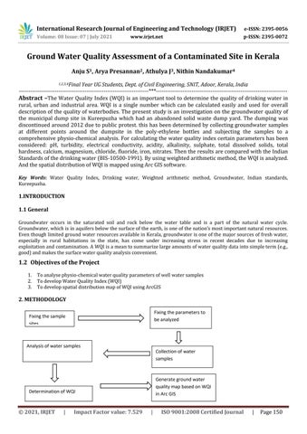
2. METHODOLOGY Fixing the parameters to be analyzed
Fixing the sample sites
Analysis of water samples Collection of water samples
Generate ground water quality map based on WQI in Arc GIS
Determination of WQI
© 2021, IRJET
|
Impact Factor value: 7.529
|
ISO 9001:2008 Certified Journal
|
Page 150