International Research Journal of Engineering and Technology (IRJET)
e-ISSN: 2395-0056
Volume: 08 Issue: 06 | June 2021
p-ISSN: 2395-0072
www.irjet.net
Design of urban drainage system using SWMM Suma Majeed1, Chinnamma M A2 1Student,
Environmental Engineering, Malabar College of Engineering and Technology, Kerala, India Environmental Engineering, Malabar College Of Engineering and Technology, Kerala, India ---------------------------------------------------------------------***---------------------------------------------------------------------2Professor,
Abstract - Urban flooding is modern day problem faced by
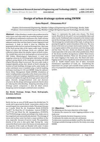
Figure 1.1 represents the study area chosen. The three wards, Ward No 65, 66 and 67 are surrounded by lakes and other wards. Vembanad Lake is situated on the western side and all the drainage outlets are carrying the water to the lake .The drainage lies on both sides of the roads. A railway line is passing through the eastern boundary of the area. The area drains in the town act as major storm water receivers. There is no regular pattern of the area drains and it lies along roads and bye lines. The area drains are absent in many of the roads especially in the areas with urban proliferation. Most of the drains overflow during heavy rainfall. These drains need immediate attention. These are the primary cause of the water logging in the study area. The flood and water logging causes various significant social and economic issues such as health related issues, loss of labor, increased maintenance expenditure of roads, etc. Considering the importance of a proper and scientific drain system in that area, it is proposed to implement a storm water management system.
many towns and cities when the prevailing drainage system isn’t sufficient to withstand a continuous rain. Under extreme weather conditions the current drainage isn’t able to provide adequate water flow and thus leads to water logging of road pavements. A study on Kochi is done by collecting the geographical data such as road and drainage lines. Base map of the Kochi giving idea of the region under study. Existing layout of towns and drainage works are collected. Next collection of data about the weather report of Kochi is done. The rainfall data and storm hydrographs are procured from IMD (Indian Meteorological Department). A total area mapping is done by Arc GIS (Geographic Information System) software giving details of the landscape including the DEM (Digital Elevation Map) is procured. The area under study is mapped digitally giving clear details of Kochi showing the location of road, buildings, drainage works, water bodies. An urban catchment area is modeled using a hybrid modeling technique involving Arc GIS and SWMM. Using the software Storm Water Management Model (SWMM) simulations of water runoff quantity and quality in the chosen area is done. It contains a hydraulic modeling capabilities used to route runoff and external inflows through the drainage system network of pipes, channels, storage/treatment units and diversion structures. By this, design of drainage system for Kochi is done for reducing the urban flooding. Designing and sizing of new drainage system components is done for flood control. Designing control strategies combined sewer overflows. Key Words: Drainage, Design, Flood, Hydrographs, Elevation, Software
1.INTRODUCTION Kochi city has an area of 94.88 square km divided into 74 wards and is governed by Kochi corporation, which is the second largest city corporation in India. This project focuses on 3 wards. Ward No. 66: Ernakulum North (9.9920’N 76.2877 ‘E), Ward No. 67: Ernakulum Central (9.9807’N, 76.2777’E) and Ward No. 68: Ayyappankavu (9.9959’N, 76.2793’E).Drainage system prevailing in the study area is less organized and unscientifically planned. The drainage of storm and surface water has been a major problem in the area, especially because of narrow roads. The population density of the area is also quite high. During the rainy season the flood water enters the houses at many places and the majority of the roads are flooded with water. It takes hours and, in some occasion, days to overcome the situation.
© 2021, IRJET
|
Impact Factor value: 7.529
1.1 Objectives
Figure 1.1 study area
The following are the main objectives of the study: To identity the reasons for water logging problems in the study area To develop intensity duration frequency curves. To delineate the study area into sub catchments To determine maximum probable runoff for the study area To design suitable drainage system for the study area using SWMM
|
ISO 9001:2008 Certified Journal
|
Page 311