International Research Journal of Engineering and Technology (IRJET)
e-ISSN: 2395-0056
Volume: 07 Issue: 08 | Aug 2020
p-ISSN: 2395-0072
www.irjet.net
“IDENTIFICATION OF WATER BODIES BY FUSION OF REMOTE SENSING IMAGES” - A REVIEW Mrs. Sheelu Dubey1, Dr. A.D. Prasad2 1M-Tech
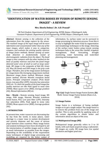
Student, Department of Civil Engineering, NITRR, Raipur, Chhattisgarh, India Professor, Department of Civil Engineering, NITRR, Raipur, Chhattisgarh, India ---------------------------------------------------------------------***---------------------------------------------------------------------Abstract- Remote sensing is the collection of the information. So, surface water can be surveyed in information from the image capture by the sensor. image processing by detection process. From this it The resultant image of the input image will be more is easy to highlight the water body by segmentation informative and consummated rather than any of the and morphology techniques in the image. Detecting input images, which makes it easy to categorize, of the surface water bodies using remote sensing compare, and evaluate the existing quality matrices techniques help in the areas like rainfall, irrigation of image fusion methods. Remote sensing of water management, flood forecasting, drought body detection is fundamentally rooted of monitoring, water harvesting and watershed electromagnetic radiation from the object. The fused planning and management. image is inter compare with the other method on the basis of quality matrices and from the fused image detected water area of small as well as large water body. MS image is the composite of Red (R), Green (G), Blue (B) bands and PAN image is the gray scale image. Therefore, few of the image fusion techniques for image fusion like Averaging image fusion method, Maximum image fusion method, Minimum image fusion method, Discrete Wavelet transform based fusion, Principal component analysis (PCA) based fusion, Low pass filter (HPF), Intensity hue saturation (IHS) etc. To check the quality of the fused image few quality matrices are like Peak signal to noise ratio (PSNR), Mean square error (MSE), Average gradient (AG), Mutual information (MI) etc. Fig-1 (a): Single Sensor Image Fusion System, (b): Multi- Sensor Image Fusion System (Rane et al., Key – Words : Remote sensing, fused image, MS 2014) image, PAN image, Discrete Wavelet transform based fusion, PCA, Low pass filter (LPF), Intensity 1.1 Image Fusion hue saturation (IHS), Peak signal to noise ratio (PSNR), Mean square error (MSE), Average gradient Image fusion is a technique of fusing multiple (AG). images so to get a single output. The image fusion is to remove the problem from one of the image and 1. INTRODUCTION another. This is only possible by applying some of the certain algorithms to obtain better and At present time, water resources are decreasing day informative about an object of the area. by day from the world, in many places, water shortage is a major issue to sustain development 1.2 Multispectral image (MS) and poverty dispense and the cause of serious pique between some countries. Many image fusion Multispectral image generally refers to 3 to 10 and analysis techniques have been developed to aid bands, with each band acquired using a radiometer. the interpretation of satellite images and to collect MS images are costly. MS image have low spatial as much information as possible from the images. resolution and higher pixel size. Depending on the availability of the requirement many techniques of digital image processing and modelling are required for the better output of 2Assistant
© 2020, IRJET
|
Impact Factor value: 7.529
|
ISO 9001:2008 Certified Journal
|
Page 3805