International Research Journal of Engineering and Technology (IRJET)
e-ISSN: 2395-0056
Volume: 07 Issue: 08 | Aug 2020
p-ISSN: 2395-0072
www.irjet.net
Analysis of Narwa Restoration Plan Amit Choudhary1, Prof. Piyush Das2 Scholar, Kalinga University, Naya Raipur, (C.G), India Professor, Department of Civil Engineer Kalinga University Naya Raipur, (C.G) India -------------------------------------------------------------------***-----------------------------------------------------------------------2Associate
1Research
ABSTRACT: Narwa (rivulets and streams) focuses on low cost water conservation structures such as test dams, gully controls, underground dykes at strategic places on water streams in order to make certain harvesting floor water and recharge of subsoil as well as groundwater. National watershed will at the same time execute the programed. The direct result will be an amplify in arable area with a double crop. This is most wished as only 1.8 million hectares are under Rabi in the nation – one-third of Khariff, in spite of enviable rainfall and a substantial internet of rivulets and streams Chhattisgarh is blessed with. Secondly, as 69 per cent of irrigation is dependent on groundwater, the absence of floor water conservation can lead to quick depletion of the treasured resource. Hence, Narwa, a scientific initiative. Besides, it's environmental-friendly with zero displacements of both flora or fauna. Moreover, it benefits the human beings and natural world alike in a country that has half of its topography covered with forests and nearly 34 per cent of human beings – the Scheduled Tribes, making forests their home.
2
3
81°44'44.93"E) Middle Check Dam (21° 40' 22.71"N,81° Duldula Duldula 44' 37.06"E) Exit point Check Dam ( 21° Bansakar 40'57.33"N,81° Bansakara a 44'25.01"E)
2. MAP STUDY The map may be a a charcterised depiction emphasizing relationships between elements of some space, such ,Many maps are static, constant to paper or another long lasting medium, while others are dynamic, or interactive. Although most in many instances accustomed depict geography, maps can also represent any space, actual or fictional, besides regard to context or scale, like in talent mapping, DNA mapping, or laptop community topology mapping. The space being mapped can also be two dimensional, just like the surface of the planet , three dimensional, just like the indoors of the planet, or even more summary spaces of any dimension, like occur in modelling phenomena. Although the earliest maps regarded are of the heavens, geographic maps of territory have a very lengthy subculture and exist from historical times. The phrase "map" comes from the Medieval Latin Mappa mundi, whereby mappa supposed napkin or fabric and mundi the earth. Thus, "map" grew to become the shortened term concerning a two-dimensional illustration of the bottom of the world
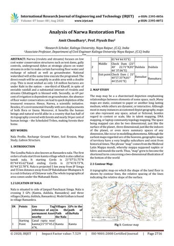
KEY WORDS: Nala Profile, Recharge Ground Water, Soil Erosion, Map Study, Gabion Structure. 1. INTRODUCTION The Gondha Nala is also known as Bansankra nala. The first orders of nala start from kamta village which is also called as tumdi nala. It starting Cords is 21°37'51.75"N 81°44'45.62"Eand ending Cords is 21°41'8.73"N, 81°44'22.78"E. Nala is projected 5 km away from JP Simga and 55 km distance away from ZP Balodabazar-Bhatapara. It is a sub tributary of Chitawar nala.The whole topographical area comes under the Mahanadi Basin.
2.1 Contour Map: A topographic map on which the shape of the land floor is shown by contour lines, the relative spacing of the lines indicating the relative slope of the surface.
1.2 LOCATION OF NALA Nala is situated to side of Janpad Panchayat Simga. Nala is crossing 3 GPs (Kamta, duldula, Bansankra) and three villages (Kamta, duldula, Bansankra). Model Gothan is found in village Bansankra. SN
Points
1
Starting Point
© 2020, IRJET
Geo Tag Villages GPs in the reference of any in the path of permanent Asset Path of theNala nearby the Nala Canal rapta near kamta(21°37'45.2 Kamta Kamta 4"N,
|
Impact Factor value: 7.529
Fig 1: Contour map
|
ISO 9001:2008 Certified Journal
|
Page 2716