International Research Journal of Engineering and Technology (IRJET) Volume: 07 Issue: 07 | July 2020 www.irjet.net
e-ISSN: 2395-0056 p-ISSN: 2395-0072
POINT CLOUD GENERATION AND RECONSTRUCTION OF SMALL TO MODERATE SIZED OBJECTS FROM VIDEOS USING VISUAL SFM AND MESH LAB Aishwarya Chandel1, S.K.S. Yadav2, Joyeeta Poddar3 1,2,3Remote
Sensing Application Center, Lucknow (UP) -------------------------------------------------------------------***----------------------------------------------------------------
ABSTARCT: Photogrammetry has many aspect as we all know and can be used in many ways and several time for detection and storage of the object. The main aim of this study is to present a new measurement method to improve the positioning verification phase in the part dimensional validation process of creating 3D models, and to store it for further use. This enhancement would improve the measuring procedures for certain types of components. A photogrammetry-based system was implemented to take advantage of its capabilities, adding new functions to the existing capacities. In addition to a new technology focused on modeling photogrammetry and processing of images, a measuring technique based on optical and vision system requirements was developed.. The limited availability of conservation and restauration funds, the digital documentation objects and monitoring of deformations caused by the climate are increasingly critical for maintaining the cultural heritage. Our Study sheds light on advances in digital image capture and processing to document objects with a focus Calibration of mobile/digital camera, near range imaging and photogrammetric simulation of complex structures using image Alignment methods or photographic sequences and developing an point cloud data through it and buy introducing it into mesh lab software to develop a 3-D model out of it so that it could be stored and can be further used for betterment our reconstructing of the object.
clouds. Instead, these point clouds can be processed using the same 3D scanning software used. Applications for this technology abound. Each of these technologies has its advantages and disadvantages (regarding the resulting accuracy for various distances of scanning vs. imaging, mobility, radiometric and geometric resolution, or purchase cost). Currently, a number of criteria – primarily high precision, level of detail, sophistication and reliability of data , which in turn must be of geometric and visual quality with efficient collection and low volume, are placed on the resulting data obtained by each of these technologies. One of the big developments in 3D surface reconstruction, computer modeling and cultural heritage documentation is only achieving a low purchasing cost while at the same time obtaining accurate results that will meet the above requirements. The new laser scanning and digital photogrammetry technologies and methods satisfy these criteria to a large degree, but in some situations the purchasing cost of the hardware and software might still be too great. Photogrammetry-dependent modeling is considered one of the best practices for processing image data which provides accuracy and detailed 3D data.
Keywords: close-range photogrammetry, mobile camera/digital camera, image/photographic sequence, surface and geometric deformations, ortho-photographic model, Visual SFM and Mesh lab software, GUI(graphical User Interface) application. INTRODUCTION Close-range photogrammetry (CRP) is simply photogrammetric data collection and processing where the subject is less than 1,000 feet away. Methods of collection can be both land- or aerial-based, and the final output can be made either in two or three dimensions. Several factors made this a valuable tool for professionals in the geospatial field. The best of these is the recent emergence of 3D photogrammetry, also called "multi-ray photogrammetry": a technique that takes overlapping, stereo-paired images, transforming them into 3D point
Š 2020, IRJET
|
Impact Factor value: 7.529
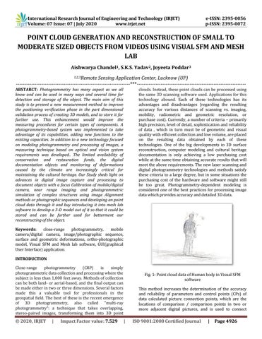
Fig. 1: Point cloud data of Human body in Visual SFM software This method increases the determination of the accuracy and reliability of parameters and control points (CPs) of data calculated picture connection points, which are the locations of comparison / comparison points in two or more adjacent digital pictures, and is used to connect
|
ISO 9001:2008 Certified Journal
|
Page 4926