International Research Journal of Engineering and Technology (IRJET) Volume: 07 Issue: 07 | July 2020 www.irjet.net
e-ISSN: 2395-0056 p-ISSN: 2395-0072
Decadal Sodic Land Change in Bewar Branch Canal Command using Isodata Algorithm Renu Kumari1*, Abhishek Kumar1, Narendra Kumar2, Dr. R. K. Upadhyay1 1*,1,2Remote
Sensing Applications Centre Uttar Pradesh, Lucknow
--------------------------------------------------------------------***----------------------------------------------------------
Abstract— Sodic land occurs due to high sodicity in soils accumulated naturally or anthropogenically. The excessive amount of salt in soil could lead to adverse effects, both, environmentally and socially. Bewar Branch Canal Command lies in semi-arid region of Uttar Pradesh. The study focuses on estimation of sodic land using the ability of Landsat 5 data for 2009 and Landsat-8 data for 2019 and Isodata algorithm to know decadal change in the branch canal command. The main benefit of Isodata algorithm is that it allows different numbers of clusters during iterations. The net decadal decrease in sodic land area from in Bewar Branch Canal Command from 2009 to 2019 has been estimated to be 9713.9 ha. Keywords— Sodic Land, Decadal Change, Landsat 5, Landsat 8, Isodata Algorithm.
1. INTRODUCTION Soil represents a considerable part of natural resources. The presence of excessive amount of dissolved salts in soil and ground water is a characteristic feature in many parts of the including India. These salts contain sodium, calcium and magnesium as the main cations, and, carbonate, bicarbonate, chloride and sulphate as associated anions. The origin and accumulation of salts in Indo-Gangetic plain is due to sodium chloride in the soils and ground water coming from Himalayan catchment (both from geological and rain water) and partly due to rainfall occurring in plains [3]. The soils with pH higher than 7 and electrical conductivity more than zero are characterized as sodic soils. These soils are widespread in India. The mapping of sodic land of an area can be done by digitization, supervised or unsupervised classification [4]. It can also be mapped using salinity indices based on different spectral bands [1]. The paper adopted a collative approach that included the use of Landsat 2 MSS False Color Composites, top maps surveys, and restricted field controls to map saline soils and wetlands. The result showed that the separation of saline and waterlogged is feasible due to their distinct coloration and peculiar pattern on false colour composite imageries [2].
TABLE I EXTENT OF BEWAR BRANCH CANAL COMMAND
Command
Bewar Branch Canal Command
Latitude Range
27°47’36.055” N - 27°1’43.403” N
Longitude Range
78°39’32.989” E - 79°33’2.845” E
TABLE II DISTRICTS IN BEWAR BRANCH CANAL COMMAND
Command
Districts
Percentage
Bewar Branch Canal Command
Farrukhabad
0.92
Kanshiram Nagar
1.30
Kannauj
10.53
Etah
32.71
Mainpuri
54.54
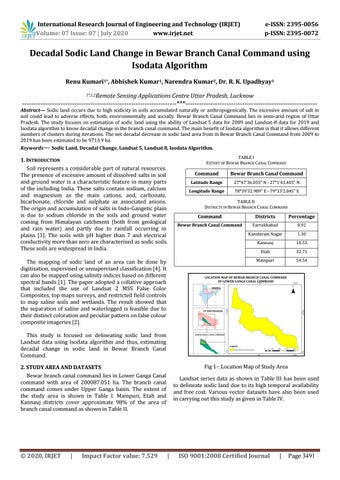
This study is focused on delineating sodic land from Landsat data using Isodata algorithm and thus, estimating decadal change in sodic land in Bewar Branch Canal Command. Fig 1-: Location Map of Study Area
2. STUDY AREA AND DATASETS Bewar branch canal command lies in Lower Ganga Canal command with area of 200087.051 ha. The branch canal command comes under Upper Ganga basin. The extent of the study area is shown in Table I. Mainpuri, Etah and Kannauj districts cover approximate 98% of the area of branch canal command as shown in Table II.
© 2020, IRJET
|
Impact Factor value: 7.529
Landsat series data as shown in Table III has been used to delineate sodic land due to its high temporal availability and free cost. Various vector datasets have also been used in carrying out this study as given in Table IV.
|
ISO 9001:2008 Certified Journal
|
Page 3491