International Research Journal of Engineering and Technology (IRJET) Volume: 07 Issue: 07 | July 2020
www.irjet.net
e-ISSN: 2395-0056 p-ISSN: 2395-0072
PHYSICO-CHEMICAL ANALYSIS OF GROUND WATER OF BHATHAT BLOCK OF GORAKHPUR DISTRICT USING WQI AND GIS TECHNIQUES Anup Agrahari1, Arunanjay shukla2, Dr. Arvind Mathur3, Dr. Sudhakar Shukla4, 1M.
Tech student, Remote Sensing Applications Centre Uttar Pradesh, India Tech student, Remote Sensing Applications Centre Uttar Pradesh, India 3Scientist-E, Soil Resources Division, Remote Sensing Applications Centre Uttar Pradesh, India 3Head (Scientist-E), School of Geoinformatics, Remote Sensing Applications Centre Uttar Pradesh, India ---------------------------------------------------------------------***---------------------------------------------------------------------Abstract - Ground water is significant constituent of human life support system and it is utilized for domestic, industrial and 2M.
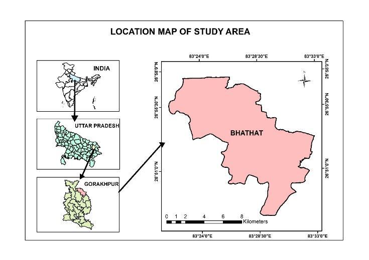
watering purposes. In India, the vast majority of the population is reliant on ground water which is one of the principle wellsprings of drinking water flexibly. Anyway because of quick development of population, urbanization, industrialization and agriculture exercises, ground water assets are under pressure. Consequently, it is important to screen the water quality of physico-chemical parameters. This study evaluates the physico-chemical properties of ground water such as, Electrical Conductivity (EC), pH, Fluoride (F), Total Hardness (TH), Total Dissolved Solids (TDS), Magnesium (Mg), Calcium (Ca), Nitrate (NO 3), by collecting 13 water samples from hand pumps (India Mark II) which is well distributed within Bhathat Block of Gorakhpur District in November, 2019. Each physico-chemical parameter was contrasted to the acceptable minimum limit specified by the BIS Indian Standards (IS 10500:2012). Global Positioning System was utilized to plot the water sample locations and mapping of water quality was finished by utilizing Inverse Distance Weighted (IDW) Interpolation method in ArcGIS 10.2.2. This study evaluates water quality status of Bhathat Block of Gorakhpur District region and identification of filthy zones so that the proper corrective procedures can be taken. Key Words: Water Quality, Inverse Distance Weighted (IDW), physico-chemical, spatial distribution.
INTRODUCTION In the current circumstance, in a large portion of the urban areas in India, the day by day water request is met by groundwater use, as the surface water is either lacking or contaminated. Groundwater is the primary source that is ordinarily utilized for drinking and water system purposes in rustic, urban and semi urban territories (Magesh & Chandrasekar, 14 december 2011). By and large, the investigations of physiochemical and biological parameters lead to survey the nature of groundwater (Fatombi, Ahoyo, Nonfodji, & Aminou, December 2012). Hydro chemical qualities of groundwater can likewise be examined for the groundwater evaluation ( Ranjan, Ramanathan, Parthasarathy, & kumar, 01 june 2012). Geographic Information System (GIS) planning procedure is the best delegate apparatus in the evaluation of groundwater quality and its use for irrigation, drinking and constructional needs (Ravikumar & Somashekar, 27 November 2011; Srinivasamoorthy, 2011). ArcGIS Software can achieve better understanding of groundwater quality by representing the data (Thiyagarajan & Baskaran, 24 december 2011). There is a chance of changes in groundwater quality because of hydrology and geologic conditions over some undefined time frame (Pandey & Tiwari, 2009). Besides, ill-advised removal of waste or trash are one among the essential elements for groundwater contamination (Abinandan, Anand , & Subramaniam, 2014). The present study was carried out in the Bhathat block, located positioned in Gorakhpur district in Uttar Pradesh. However, the major source of drinking water for the district is groundwater which is already contaminated due to industrial establishments. The datasets for the groundwater were compared with Bureau of Indian Standards (BIS) and World Health Organization (WHO) standards to ensure the quality of the water.
1.1 Objectives of the Present Study The objectives of the present study are given below• • • •
To plot the GPS points of that water sample location in map To assess the physico-chemical parameters of water To compute the Water Quality Index (WQI) To create spatial distribution maps of that parameters
© 2020, IRJET
|
Impact Factor value: 7.529
|
ISO 9001:2008 Certified Journal
|
Page 3445