1 minute read
3 Software

from IRJET- Physico-Chemical Analysis of Ground Water of Bhathat Block of Gorakhpur District using WQ

International Research Journal of Engineering and Technology (IRJET) Volume: 07 Issue: 07 | July 2020 www.irjet.net e-ISSN: 2395-0056 p-ISSN: 2395-0072
2. STUDY AREA
Advertisement
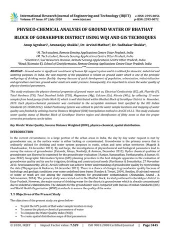
Bhathat is a block positioned in Gorakhpur district in Uttar Pradesh. It has 95 villages.There are 61 Panchayats inBhathat block. It is situated 22 KM towards North from District headquarters Gorakhpur. It is a block head quarter. It is located 289 KM from state capital Lucknow. The coordinates of the Bhathat block is 26.8980° N and 83.4886° E. The elevation of Bhathat block is 85 mt (altitude).
Fig -1: Location map of the study area
3. DATA AND SOFTWARE USED
3.1 Data Used
Layout map of Bhathat block Ground water quality parameter Survey of India toposheet.: 63N/3, 63N/5, 63N/6, 63N/10, and 63J/15
3.2 Instruments
Global Positioning System Water quality field kit Digital pH-meter Digital conductivity meter UV-VisibleSpectrophotometer
3.3 Software
ArcGIS 10.2.2 Microsoft package UV-Analyst software
4. METHODOLOGY
4.1 Sample Collection
An aggregate of 13ground water tests were gathered from India Mark II handpump which is very much dispersed inside Bhathat block ofGorakhpur district. Global Positioning System (GPS) was utilized to find the water test areas and mapping of water quality was finished utilizing Inverse Distance Weighted (IDW) Interpolation procedure in ArcGIS 10.2.2. Each example was gathered by 1 liter corrosive washed polyethylene HDPE bottle. The container was completely loaded up with water taking consideration that no air bubble was stuck inside the water test. Precautionary measure was additionally taken to keep away from test unsettling influence during move to the research facility. Electrical conductivity