International Research Journal of Engineering and Technology (IRJET)
e-ISSN: 2395-0056
Volume: 06 Issue: 04 | Apr 2019
p-ISSN: 2395-0072
www.irjet.net
Watershed Delineation of Kumbhoj Nala Basin by using QGIS Vinayak Pandav1, Gautam Kamble2, Haree Rupnar3, Shridhar Madiwalkar4, Ajit Lole5 1,2,3,4Students,
Department of Civil Engineering, Sanjay Ghodawat Group of Institution, Atigre, Kolhapur. Department of Civil Engineering, Sanjay Ghodawat Group of Institution, Atigre, Kolhapur. ---------------------------------------------------------------------***---------------------------------------------------------------------5Professor,
Abstract - The vast area covered by the Maharashtra can become a problem when studying water resources issues. For example, the western portions of Maharashtra receive an abundant amount of rain, while the eastern portions are virtually dry. Geographical information system tool (GIS) has wide range of application and comes with grass interface and user support. Numerous studies on watershed water and soil resources management have been done using the GIS modeling. The GIS modeling is a computer based and computationally efficient tool; it uses available inputs viz. Vector and raster and lets users to study long-term impacts. Now a Day by Day the ground water table going decreases, therefore watershed delineation is necessary for nalas of villages.
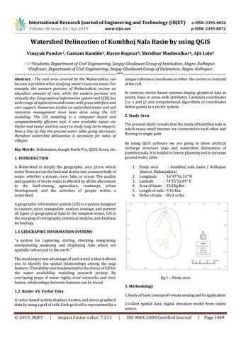
unique reference coordinate at either the corner or centroid of the cell. In contrast, vector based systems display graphical data as points, lines or areas with attributes. Cartesian coordinates (i.e. x and y) and computational algorithms of coordinates define points in a vector system. 2. Study Area The present study reveals that the study of kumbhoj nala in which many small streams are connected to each other and flowing in single path. By using QGIS software we are going to show artificial recharge structure map and watershed delineation of kumbhoj nala. It is helpful to future planning and to increase ground water table.
Key Words: Delineation, Google Earth Pro, QGIS, Grass, etc. 1. INTRODUCTION A Watershed is simply the geographic area prove which water flows across the land and drains into common body of water, whether a stream, river, lake, or ocean. The quality and quantity of storm water is affected by all the alterations to the land-mining, agriculture, roadways, urban development, and the activities of people within a watershed.
1. Study area : kumbhoj nala basin ( Kolhapur district, Maharashtra) 2. Longitude : 16˚47’56.14” N 3. Latitude : 74˚25’52.09” E 4. Area of basin : 33.6Sq.Km 5. Length of nala : 9.16 Km. 6. Order of nala : IIIrd order
A geographic information system (GIS) is a system designed to capture, store, manipulate, analyze, manage, and present all types of geographical data In the simplest terms, GIS is the merging of cartography, statistical analysis, and database technology. 1.1 GEOGRAPHIC INFORMATION SYSTEMS "a system for capturing, storing, checking, integrating, manipulating analyzing and displaying data which are spatially referenced to the earth." The most important advantage of such a tool is that it allows you to identify the spatial relationships among the map features .This ability was fundamental in the choice of GIS for the water availability modeling research project. By overlaying maps of water rights, river networks and river basins, relationships between features can be found.
fig.1 – Study area 3. Methodology
1.2. Raster VS. Vector Data
1.Study of basic concept of remote sensing and its application.
A raster-based system displays, locates, and stores graphical data by using a grid of cells. Each grid cell is represented by a
© 2019, IRJET
|
Impact Factor value: 7.211
2.Collect spatial data, digital elevation model from online source.
|
ISO 9001:2008 Certified Journal
|
Page 1469