International Research Journal of Engineering and Technology (IRJET)
e-ISSN: 2395-0056
Volume: 04 Issue: 09 | Sep -2017
p-ISSN: 2395-0072
www.irjet.net
An Automatic Detection of landing sites for emergency Landing of Aircraft Ms.Supriya Laxman Thorat1, Dr.Sanjay Mohite2 1
M.E (Digital System), JSPM’s JSCOE Pune,India. Associate Professor, JSPM’s JSCOE Pune, India. ---------------------------------------------------------------------***--------------------------------------------------------------------2
Abstract -. . This paper proposes an automatic computer aided detection (CAD) system to help pilots to find emergency safe landing sites in the emergency situation. The emergency landing can be caused by many reasons due to lack of fuel, whether changing, rain, disaster. So, in the emergency situation landing should be as soon as possible on high priority. The most chances of emergency landing is engine failure and running out of fuel so the aircraft will lose flying capacity so the pilot have to make quick decision of landing in some minutes. so time is another vital critical factor in taking decision of landing because quick decision is important while landing.Therefore,a simple robust and very efficient algorithm is for selecting the landing sites is desired.
mainly determined by its surface roughness and dimensions. The roughness of terrain can be measured by gradient of elevation if we have information of elevation map of terrain the gradient information can be easily found and safeness can be accurately estimated. The vision Based channel is more important which provides real time Paragraph comes content here. Imagery on ground. In practical more aircraft do not have either database of elevation maps. The proposed system helps pilot to choose safe landing sites. The safe landing has to be chosen by pilots it depends on 10% on the pilot and 90% on the system. Pilot has to make quick decision to choose safe landing site[1]. 2. BLOCK DIAGRAM
Key Words: Canny detector, K-Clustering, Horizon Detection
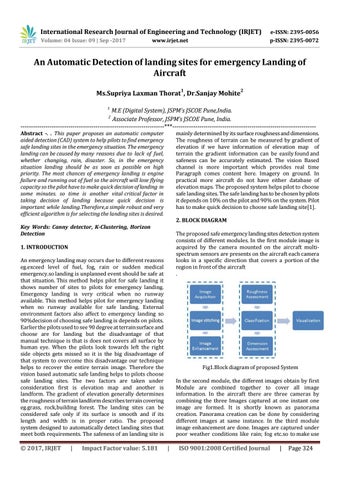
The proposed safe emergency landing sites detection system consists of different modules. In the first module image is acquired by the camera mounted on the aircraft multispectrum sensors are presents on the aircraft each camera looks in a specific direction that covers a portion of the region in front of the aircraft .
1. INTRODUCTION An emergency landing may occurs due to different reasons eg.exceed level of fuel, fog, rain or sudden medical emergency.so landing is unplanned event should be safe at that situation. This method helps pilot for safe landing it shows number of sites to pilots for emergency landing. Emergency landing is very critical when no runway available. This method helps pilot for emergency landing when no runway available for safe landing. External environment factors also affect to emergency landing so 90%decision of choosing safe landing is depends on pilots. Earlier the pilots used to see 90 degree at terrain surface and choose are for landing but the disadvantage of that manual technique is that is does not covers all surface by human eye. When the pilots look towards left the right side objects gets missed so it is the big disadvantage of that system to overcome this disadvantage our technique helps to recover the entire terrain image. Therefore the vision based automatic safe landing helps to pilots choose safe landing sites. The two factors are taken under consideration first is elevation map and another is landform. The gradient of elevation generally determines the roughness of terrain landform describes terrain covering eg.grass, rock,building forest. The landing sites can be considered safe only if its surface is smooth and if its length and width is in proper ratio. The proposed system designed to automatically detect landing sites that meet both requirements. The safeness of an landing site is
Š 2017, IRJET
|
Impact Factor value: 5.181
Fig1.Block diagram of proposed System In the second module, the different images obtain by first Module are combined together to cover all image information. In the aircraft there are three cameras by combining the three Images captured at one instant one image are formed. It is shortly known as panorama creation. Panorama creation can be done by considering different images at same instance. In the third module image enhancement are done. Images are captured under poor weather conditions like rain; fog etc.so to make use
|
ISO 9001:2008 Certified Journal
|
Page 324