International Research Journal of Engineering and Technology (IRJET) Volume: 04 Issue: 08 | Aug -2017
www.irjet.net
e-ISSN: 2395-0056 p-ISSN: 2395-0072
FLOODPLAIN MAPPING OF RIVER KRISHNANA USING HEC-RAS MODEL AT TWO STREACHES NAMELY KUDACHI AND UGAR VILLAGES OF BELAGAVI DISTRICT, KARNATAKA Sandhyarekha1, A. V. Shivapur2 1M.tech
Student, Dept. of Water and Land Management, CPGS, VTU Belagavi, Karnataka, India Dept. of Water and Land Management, CPGS, VTU Belagavi, Karnataka, India ------------------------------------------------------------------------***------------------------------------------------------------------------2Professor,
2. STUDY AREA AND DATA USED
Abstract - natural hazards are synonym for Floods that
influencing severe economic damages and cause impact to human lives. It is always necessary to estimate scenarios of flood for accurate temporal and spatial information on the risks of floods and its potential hazards. This study includes two main objectives; during the worst flood event the flooded area cover, along Krishna River to be calculate and to produce floodplain map of flooded areas. In order to achieve these objectives, the HEC-RAS hydraulic model were used as tools. As a result, the watershed area of the Krishna basin has been successfully modelled and map showing the flooded areas along the part of Krishna basin has been delineated. The floodplain map produced clearly shows the spatial distribution of the flooded area. Generally, high water depth flow along the main channel and spreads gradually to the floodplains. The total flooded area covers at 100 yr. return periods approximately 300 acres near Kudachi and 116 acres near Ugar village along Krishna River. Thus, integration of geospatial process and hydraulic modelling can produce inundation flood map with good accuracy.
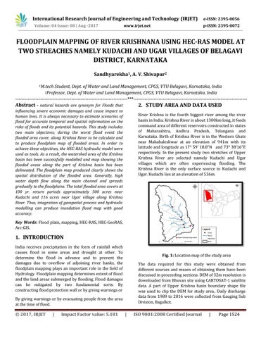
River Krishna is the fourth biggest river among the river basin in India. Krishna River is about 1300km long, it feeds command area of different reservoirs constructed in states of Maharashtra, Andhra Pradesh, Telangana and Karnataka. Birth of Krishna River is in the Western Ghats near Mahabaleshwar at an elevation of 941m with its latitude and longitude as 17 59’ 18.8”N and 73 38’16”E respectively. In the present study two stretches of Upper Krishna River are selected namely Kudachi and Ugar villages which are often experiencing flooding. The Krishna River is the only surface source to Kudachi and Ugar. Kudachi lies at an elevation of 536m.
Key Words: Flood plain, mapping, HEC-RAS, HEC-GeoRAS, Arc-GIS.
1. INTRODUCTION India receives precipitation in the form of rainfall which causes flood in some areas and drought at other. To determine the flood in advance and to prevent the damages due to overflow of adjoining river banks, the floodplain mapping plays an important role in the field of Hydrology. Floodplain mapping determines extent of flood and the land areas submerged by flooding. Flood damages can be mitigated by two fundamental sorts: By constructing flood protection wall or by giving warnings or
Fig. 1: Location map of the study area The data required for this study were obtained from different sources and means of obtaining them have been discussed in proceeding sections. DEM of 32m resolution is downloaded from Bhuvan site using CARTOSAT-1 satellite data. A part of Upper Krishna basin boundary shape file was used to clip the DEM for study area.. Daily discharge data from 1989 to 2016 were collected from Gauging Sub Division, Bagalkot.
By giving warnings or by evacuating people from the area at the time of flood.
© 2017, IRJET
|
Impact Factor value: 5.181
|
ISO 9001:2008 Certified Journal
|
Page 1524