International Research Journal of Engineering and Technology (IRJET)
e-ISSN: 2395 -0056
Volume: 04 Issue: 06 | June -2017
p-ISSN: 2395-0072
www.irjet.net
BORDER ALERTING SYSTEM FOR FISHERMEN USING GPS MODULE Sindhu S Rao1, Saraswathi Devi V G2,Lokesh B S3 1,2UG
Student, Department of Electonics and Communication Professor, Department of Electronics and Communication
3Assistant
The National Institute of Engineering, Mysuru, Karnataka, India
---------------------------------------------------------------------***--------------------------------------------------------------------3. PROPOSED SYSTEM Abstract – Fishing is one of the oldest occupation, perhaps it is older than agriculture. Fishing in India employs about 14.5 million people. In this modern, fast moving insecure world, it has become a basic necessity to be aware of one’s safety. The maximum risks occur for fishermen in situations where they travel on a boat for fishing. In some situations, they should not enter into another country area. There is a real necessity in designing a system that can help our fishermen to avoid such situations. This paper proposes a system where a GPS module plays a major role. Here GPS and GSM are used in the same module, where GPS tracks the exact location of the boat and its value is given to the microcontroller and is continuously compared with the predefined values and the current location and its value is displayed on the LCD. When the boat crosses the predefined location (latitude and longitude), it alerts the fishermen through the buzzer and also the speed of the motor is controlled. We have practically implemented the project and tested this module at Lingambudhi lake which is located in the city of Mysuru, Karnataka.
In the proposed system, module (like SIM808) which consists of GPS and GMS modules integrated on a single board. The GPS receiver is used to find the current location of the fishing boat. Using GPS, the current latitude and longitude values can be determined and is then sent to microcontroller unit. Later the microcontroller unit finds the current location by comparing the present latitude and longitude values with the predefined value. For some set of threshold value, we consider it as normal zone and for some set of values its warning zone. Then from the result of the comparison, if the boat is in the warning zone, this system alerts the fishermen through the buzzer interfaced to the microcontroller, that they are about to reach the nautical border, and the speed of the boat can be controlled.
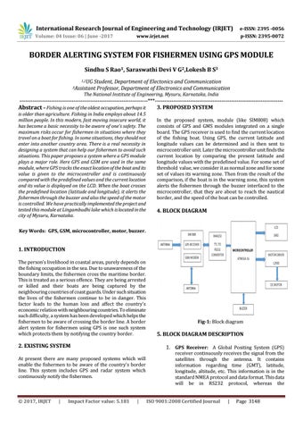
4. BLOCK DIAGRAM
Key Words: GPS, GSM, microcontroller, motor, buzzer.
1. INTRODUCTION The person’s livelihood in coastal areas, purely depends on the fishing occupation in the sea. Due to unawareness of the boundary limits, the fishermen cross the maritime border. This is treated as a serious offence. They are being arrested or killed and their boats are being captured by the neighbouring countries of coast guards. Under such situation the lives of the fishermen continue to be in danger. This factor leads to the human loss and affect the country’s economic relation with neighbouring countries. To eliminate such difficulty, a system has been developed which helps the fishermen to be aware of crossing the border line. A border alert system for fishermen using GPS is one such system which protects them by notifying the country border.
2. EXISTING SYSTEM
|
Impact Factor value: 5.181
5. BLOCK DIAGRAM DESCRIPTION 1. GPS Receiver: A Global Positing System (GPS)
At present there are many proposed systems which will enable the fishermen to be aware of the country’s border line. This system includes GPS and radar system which continuously notify the fishermen.
© 2017, IRJET
Fig-1: Block diagram
|
receiver continuously receives the signal from the satellites through the antenna. It contains information regarding time (GMT), latitude, longitude, altitude, etc. This information is in the standard NMEA protocol and data format. This data will be in RS232 protocol, whereas the
ISO 9001:2008 Certified Journal
|
Page 3148