
Volume: 11 Issue: 07 | July 2024 www.irjet.net p-ISSN: 2395-0072


Volume: 11 Issue: 07 | July 2024 www.irjet.net p-ISSN: 2395-0072
R Sai Meghana1, Meghana Kulkarni2
1Student, Dept. of ECE, Visvesvaraya Technological University, Belagavi, Karnataka, India
2 Associate Professor, Dept. of ECE, Visvesvaraya Technological University, Belagavi, Karnataka, India
Abstract - The most significant difficulty for individuals who are visually impaired involves to reach their destination. Although smart helping sticks have been produced, they need to be carried around and have restrictions The goal of the smart system "Help Me" and navigation aid functions is to greatly improve the ability to move and safety of those with visual impairments. The navigation assistance featureutilizes a GPS-based system and speech-to-text technology to provide real-time audio guidance, making users able to reach their desired destinations efficiently and independently. The "Help Me" feature is designed for emergency situations, where pressing a dedicated button activates an alert system that sends pre-configured messages along with the user's GPS location to designated contacts, ensuring immediate assistance. Together, these features offer a robust and userfriendly solution, improving the overall quality of as well as security for blind people
Key Words: Navigation assistance, GPS-based system, speech-to-texttechnology,real-timeaudioguidance.
Forthosewhoarevisuallyimpaired,gettingaboutallover maybequitedifficult,particularlyifitcomestoautonomous travelandmaintainingpersonalsafety.Thisprojectpresents cutting-edgesolutionswithtwomainelementstoaddress theseissues:navigationassistanceandanemergency"Help Me"feature.Navigationassistanceisimportantforvisually impairedindividualstotravelwithconfidenceandease.The proposedsystemintegratesGPS-basedvoicenavigationwith real-timespeechrecognitiontoprovideseamlessguidance. Byconvertingspokendestinationrequestsintoactionable directions, the system offers precise, audio-based instructionstohelpusersreachtheirintendedlocations.The GPS functionality continuously tracks the user's position, ensuring they receive accurate directions and distance information.Thisapproachnotonlysimplifiesthenavigation process but also enhances the user's autonomy, allowing them to navigate complex environments and unfamiliar areas with greater ease. In emergencies, immediate assistanceiscrucial.The"HelpMe"featureisdevelopedto offerswiftsupportincriticalsituations.Withasimplepress of the emergency button, the system sends out an alert message to pre-configured contacts, including family members and emergency services. Simultaneously, GPS
tracking provides real-time location data, enabling responderstopinpointtheuser'sexactwhereabouts.This feature ensures that help is quickly mobilized, offering an added layer of security and peace of mind for visually impaired people who could find themselves in critical situations Together,thesefeatures navigationassistance and the "Help Me" button form a comprehensive solution thatenhancesboth thefreedomand safetyof people with vision impairments, enabling them to move about their environmentmoreconfidentlyandwithsecurity
Thosewhoareblindorvisuallyhandicappedhavesignificant problems while navigating their surroundings. New developmentsintechnologyhavepromptedthecreationofa numberofsystemstargetedatimprovingobjectdetection andnavigationalskills.
Priyacreatedasmartglasses-basedassistivetechnologyfor thosewhoareblind.Fornavigation,itmakesuseoffaceand objectrecognition.Withtheuseofthistechnology,theuser canrecognizeobjectsandpeopleinfrontofthem.Onlythose whohavealreadyregisteredwiththesystemdatabasecan beidentifiedbythissystem[1].
In this work by Israh Akbar, the usage of GPS mobile applications for blind pedestrian navigation was investigated. Improving user confidence in GPS-based applications'accuracy.Thestudymadeiteasiertoanalyze andcomprehendhowblindindividualsutilizetechnologyto navigate. The study further aided in highlighting the deficiency of information provided to visually impaired individualswhennavigatingnewsurroundings.Thefactthat everyparticipantmostlyreliedonthedistancemeasuring units of the applications while being directed by the GPSbasedapplicationsfurtherdemonstratedthesignificanceof usingtherightwordsandunits[2].
Sanika Dosi developed a blind-friendly Android app that leveragesreal-timeobjectrecognitionthroughasmartphone camera.Byutilizingneural networks,theappcanidentify objectsandprovideaudiofeedbacktotheuser.Byenhancing theuser'scapacitytoidentifyandinteractwithitemsintheir surroundings, this invention may improve situational awarenessandnavigation[3]. International Research Journal of

Volume: 11 Issue: 07 | July 2024 www.irjet.net p-ISSN: 2395-0072
Ali Khan proposed assistance system that which utilizes ultrasonicsensorstoidentifyobstacles.Thewearablejacket hasvariousultrasonicsensorlocations,avibrationdevice, andabuzzer.User’ssurroundingsarescannedbysensors, which alert them to obstacles along their path by buzzing andvibrating.[4].
S. Duman introduced a portable system utilizing the RaspberryPianda camera tomeasuredistancesbetween objectsandpeople.ThesystememploystheYOLOalgorithm, a convolutional neural network-based approach for realtime object detection. It provides auditory feedback on distance calculations, offering a significant advantage in spatial awarenessandnavigationfor individualswith low vision[5].
Shahira K C developed a technology that combines YOLObasedobjectdetectionwithanultrasonicsensormountedon an Arduino. This system is designed to help visually impaired individual sense and recognize obstacles in real timewhilecalculatingtheirdistance.Theincorporationof thesetechnologiesenableseffectivenavigationbyproviding immediatefeedbackonnearbyobstructions[6].
Devshree Bharatia proposed an e-stick module integrated with a voice-activated Android application. This solution aimstoofferanaffordableand a sensiblechoiceforthose withvisualimpairments,preservingthefamiliarstructureof traditional white canes while incorporating modern technology.Thesystemenhancesnavigationbyintegrating real-time audio feedback and maintaining the traditional stick'sutility[7].
Anish Aralikatti reported on an Android-based mobile application system that utilizes real-time video from a cameraforobjectrecognition.Themechanismallowspeople with vision impairments to navigate their surroundings more safely by identifying adjacent objects and providing feedback to prevent collisions. This approach focuses on enhancing situational awareness and navigation accuracy [8].
Fayaz Shahdib presented a sensor fusion approach combining a camera and an ultrasonic sensor for mobile navigation.Thismethodallowsforthedetectionofobstacles, measurement of distances, and calculation of dimensions with minimal sensor and computing costs. The fusion of thesesensorsprovidesaneconomicalsolutionforimproving navigationcapabilities[9].
Maisha Mashiata reviewed the most advanced available assistive technology for people with visual impairments, withafocusonfeatureslikeobstacledetection,portability, andmobileassistance. This papershowcaseshowvarious technologies can be integrated to enhance navigation and overall mobility, providing a comprehensive overview of currentadvancementsinthearea[10].
A. Peterson examined into how people with impairments mayutilizeBluetoothtechnologytogetwirelessnavigation assistanceinplacesthatareavailabletothem,whichcanlet them move around more freely. The study examines how wireless connectivity might improve the mobility and accessibilityofindividualswithvisualimpairments,whichis crucialforimprovingtheirqualityoflife.[11]
Xinnan Leong proposed a system using a Raspberry Pi, camera module and sonar sensor for real-time object detection and distance estimation. The incorporation of convolutionalneuralnetworkswithhardwaredemonstrates successful real-time performance in diverse settings, validating the system's effectiveness for navigation and obstacleavoidance[12].
Lourdes Santhosh S introduced an innovative assistive technologyusingtheYOLOalgorithmforreal-timewearable glasses with obstacle detection and recognition. The RaspberryPiCPUisconnectedtoacameraandanearphone by the system, which transforms visual input into audible feedback. This technologyperformance evaluation shows how it could improve item detection and navigation in practicalsituations[13].
These all studies include a wide range of technology developments meant to help visually impaired people navigatemoreeasily.Thesedevelopmentsimprovemobility andsafetyindailysettingsbycombiningavarietyofsensors, algorithms,anduserinterfaces.
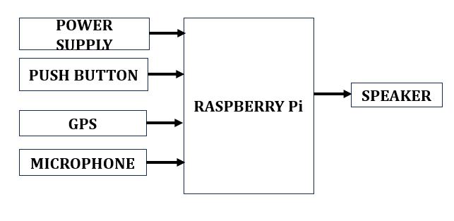
Fig.1showstheblockdiagramofassistivedeviceforvisually impairedindividualsusingaRaspberryPi,acomprehensive approach that was implemented. First, a stable 5V 2.5A powersupplywasestablishedtoensurereliableoperationof the Raspberry Pi and its peripherals. A push button was integratedintoaGPIOpintoprovide"HelpMe"feature.A GPS module connected via UART pins enabled real-time locationtracking,withsoftwarelibrariesconfiguredfordata interpretation. For audio input, a USB microphone was utilized,supportedbyaudioprocessingsoftwaretocapture andanalyzesounds.OutputwasmanagedthroughaUSBor Bluetoothspeakerforauditoryfeedbackandnotifications. Python scripts were developed to coordinate these components, handling emergency alerts, GPS data processing,audioinputmanagement,andspokenresponses, thereby creating an operational and responsive assistive device. International Research Journal of Engineering and Technology (IRJET) e-ISSN: 2395-0056

3.1
Thenavigationassistancefunctionisacriticalcomponent oftheproject,aimedatgivingthosewhoareblindorvisually handicapped comprehensive support for reaching their destinations. This functionality is designed to operate seamlesslybasedonuserinputandcurrentlocation.Initially, theusercommunicatestheirdestinationverbally,whichis captured by a speech-to-text system integrated into the navigationmodule.Thissystemconvertstheverbalinputfor the text, which is then processed to identify the desired location.
Once the destination is determined, the GPS (Global Positioning System) module calculates the user's current position and determines the route to the specified destination.GPSisasatellite-basednavigationsystemthatis usuallyusedformapping,navigation,andpositioning.Itgives time and location information anywhere on or near the Earth's surface. The system then computes essential navigational information, including the distance to the destination and directional guidance. In terms of degrees, instructions are supplied, offering precise and actionable instructions. Let’s consider, the system might instruct the blindto"turnleftat45degrees"or"proceedstraightfor200 meters."
Speech-to-text integration guarantees that users may engagewiththesysteminanaturalwaywithouthavingto enter data byhand. This designed system thus offers realtimeupdatesandguidance,makingnavigationintuitiveand accessible. By delivering clear, step-by-step directions and distanceinformation,thenavigationassistancefunctionaims to improve the user's autonomy and confidence while traveling.
The"HelpMe"featureisanessentialsafetyoperationof the assistive device, designed to offer immediate support during emergencies for visually impaired individuals. This featureincludesareadilyaccessiblebuttonthattheusercan
activateinemergencysituations.Whenpressed,thebutton sendsanemergencyalertthroughwirelesscommunication channelssuchasSMS,includingtheuser'scurrentlocation obtainedviatheGPSmodule.Toconfirmthealerthasbeen sent, the device provides auditory reassure the user. Additionally,thedevicenotifiespre-selectedcontacts,suchas familymembersorcaregivers,toensurearapidresponse.By guaranteeing that the user may promptly and efficiently request assistance, this integrated system improves their safetyandfreedominemergencycircumstances.
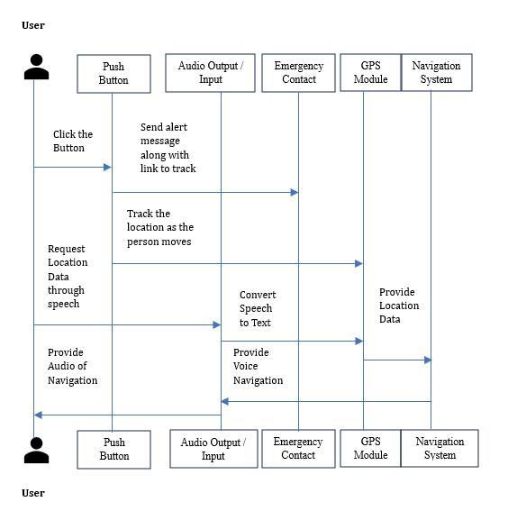
The sequence diagram below in Fig.2 illustrates a comprehensiveprocessintegratingnavigationassistanceand emergencyalertfeaturesintoanaidforthosewhoareblind or visuallychallenged. Thissystem enhances user security andindependentbyprovidingreal-timelocationdata,voice navigation,andimmediateemergencyresponsecapabilities. The diagram is divided into five key components: Push Buttons,AudioOutput,EmergencyContact,GPSModule,and NavigationSystem.
Whentheuserpressesapushbutton,anemergencyalert is triggered, sending a alert notification to predefined emergency contacts with a tracking link. The GPS module continuously tracks the user’s location, facilitating swift responses from emergency contacts. For navigation assistance,theusercanrequestlocationdatathroughspeech. Thedevicecapturestheaudioinput,convertsittotextusing a speech-to-textsystem,andprocessesthe requestvia the navigationsystem.TheGPSmoduleprovidescurrentlocation data,whichthenavigationsystemusestocalculatetheroute and convert it into spoken instructions. The user receives theseinstructionsviatheaudiooutput.
Thisintegratedsystemensuresseamlessinteraction,realtime updates, and enhanced user safety. The GPS module provides continuous location tracking, crucial for both navigation and emergency situations, while the audio feedbackkeepstheuserinformed,enablingeasyactivationof emergencyalertsandnavigationassistancewithoutrelying onvisualfeedback.

International Research Journal of Engineering and Technology (IRJET) e-ISSN: 2395-0056
Volume: 11 Issue: 07 | July 2024 www.irjet.net p-ISSN: 2395-0072
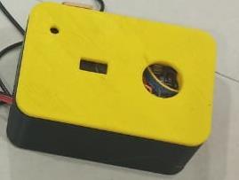
According to the project description, the physical prototype of the assistive technology intended for people withvisualimpairmentsisshowninthepicturebelowinFig.
3.Thedeviceishousedinacompactrectangularcasewitha yellowtopandblackbottom.Throughtheholescreated,the RaspberryPiislinkedtothemicrophone.TheGPSmoduleis intendedtofitinsidetheroundhole,whichgivesitastraight lineofviewforprecisereal-timepositionmonitoring.This prototypeintegratesseveralcrucialcomponents,including the GPS module for location tracking, speech-to-text technologyforconvertingverbaldestinationinputs,andan audiooutputsystemfordeliveringnavigationalinstructions andemergencyalerts.Thecompactandthoughtfuldesignof thecaseallowsforseamlessintegrationofthesetechnologies, enhancingthemobilityandsafetyofvisuallyimpairedusers
Additionally, it has a push button that visually challenged peoplecanuseinanemergency.
3.5 Advantages and Applications of the Model
Advantages:
ComprehensiveNavigationandSafety:Thedevicecombines navigation assistance and emergency support in a single, cohesivesystem,unlikemanyexistingsolutionsthataddress theseneedsseparately.Thisall-inclusivestrategyguarantees thatcustomerswillalwayshaveassistanceforbothroutine navigationandurgentsituations.
User-Friendly Interaction: By leveraging speech-to-text technology,gadgetmakesthesystemaccessibleandsimpleto usebyenablingpeopletocommunicatewithitusingnormal language.Thiswillreducethelearningcurveandmakesthe devicemorepracticalfordailyuse.
Real-TimeUpdatesandGuidance:TheincorporationofGPS technology provides real-time updates and accurate guidance, ensuring users receive the most current and preciseinformationfortheirnavigationneeds.
EnhancedSafety:The"HelpMe"featureprovidesanadded layerofsecurity,allowsusertosendemergencyalertswith theirGPSlocationtopre-configuredcontacts.Thisensures rapidassistanceincaseofemergencies,enhancingtheoverall safetyofvisuallychallengedpeople
Applications:
Enablesindependentactivitiesandeverydayconnectswith exactlocationmonitoring.
Transformsspokendestinationqueriesintotextthatmay beinteractedwithintuitively.
Increasessafetybyprovidingthelocationinanemergency tocontacts.

International Research Journal of Engineering and Technology (IRJET) e-ISSN: 2395-0056
Volume: 11 Issue: 07 | July 2024 www.irjet.net p-ISSN: 2395-0072
ProvidesRealtimeassistancetothevisuallyimpairedtothe requireddestinationthroughaudiofeedback.
The proposed system introduces several advancements compared to previous works aimed at assisting visually impaired individuals. Unlike existing solutions, which typicallyfocusonspecificaspectsofnavigationoremergency support,thepresentedsystemintegratesbothfunctionalities intoasingle,cohesivedevice.
This assistive device offers a comprehensive GPS-based navigationfeaturecombinedwithspeech-to-texttechnology. Thisallowingpeopletointeractwiththesystemusingnatural languagetosetdestinationsandreceivereal-time,step-bystep audio guidance. In contrast, previous works such as Sanika Dosi Android app and Anish Aralikatti mobile application focus primarily on object recognition and situationalawarenessratherthanfullroutenavigation.While systemslikethosedesignedbyS.DumanandXinnanLeong usecamerasandsensorsforobstacledetectionanddistance estimation, they don't rely on user input to deliver comprehensive,spokennavigationaldirections.
The "Help Me" feature of the proposed system provides immediate emergency support by sending alerts with GPS locationdata topre-configuredcontacts.Thisfunctionality addressesacriticalneedforquickassistance,whichisn’ta focusinmanyexistingsystems.Forinstance,whileDevshree Bharatia e-stick integrates real-time audio feedback for navigation, it lacks an emergency alert system. Similarly, systemslikethosepresentedbyFayazShahdibandShahiraK Cfocusonobstacledetectionbutdonotincludededicated emergencyfeatures.
The proposed system leverages a combination of GPS, speech-to-text,andaudiooutputtechnologiesintegratedinto aRaspberryPiplatform,offeringaholisticapproachtoboth navigationandemergencysupport.Previousworks,suchas Lourdes Santhosh S’s wearable spectacles and Maisha Mashiata review of assistive devices, showcase various technological advancements but generally address either navigation. The incorporation of these features in the proposedsystemensuresthatusersbenefitfrombothrealtime navigation assistance and immediate emergency supportwithinasingledevice.
The "Help Me" feature provides an essential safety mechanismforvisuallychallenged users,allowingthemto quicklyseekassistanceinemergencies.Whentheemergency buttonisclicked,thesystemcapturestheuser'scurrentGPS locationandsendsittopre-configuredcontacts.
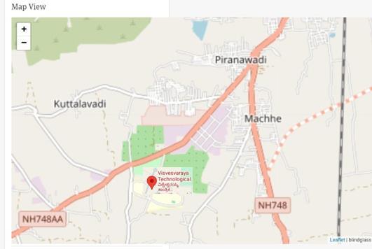
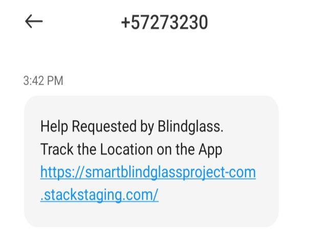
AsshowninFig.4,thisfeatureenablestheemergencycontact persontotracktheexactlocationoftheblindindividualin actual time. Additionally, as illustrated in Fig.5, an alert messagecontainingalinktotheGPSlocationisdeliveredto the emergency contact, ensuring they have precise and immediate information to respond effectively. This integration of GPS tracking and instant alert messaging significantlyenhancestheuser'ssafetybyfacilitatingswift andaccurateassistancefromfamilymembers
Thetable-1Theoutcomesofmanytestscenariosintendedto verify the assistive device's functionality for people with visual impairments are shown below. Every test case correspondstoadistinctsystemfeature.

International Research Journal of Engineering and Technology (IRJET) e-ISSN: 2395-0056
Volume: 11 Issue: 07 | July 2024 www.irjet.net p-ISSN: 2395-0072
1 Convert speechto text Convert speechto text Pass Pass
2 Getlocation datafrom theGPS module. GPSmodule gives position information. Pass Pass
3 Provide locationdata tonavigation system Navigation system receivesand processes locationdata Pass Pass
4 Deliver audio feedbackto user Audiooutput delivers feedbackto user Pass Pass
5 HelpMe Button pressedthen alert messageto besent Alert messageis sentto Emergency contact Pass Pass
Test Case TC01 confirmed that the speech-to-text functionalityisworkingcorrectly,asitsuccessfullyconverted spokenwordsintotext.TestCaseTC02verifiedthattheGPS modulecorrectlyprovidedpositioninformation,whichwas crucialforlocationtracking.Followingthis,TestCaseTC03 ensuredthatthenavigationsystemaccuratelyreceivedand processedthelocationdatafromtheGPSmodule.Lastly,Test CaseTC04testedtheaudiofeedbackmechanism,confirming that it delivered the intended audio output to the user effectively.Alltestcasespassedsuccessfully,indicatingthat thedevice'scorefeaturesspeech-to-textconversion,GPSdata retrieval,navigationdataprocessing,andaudiofeedbackare functioningasdesigned.Thisoutcomeshowsthattheentire system is operating effectively and fulfilling its intended needs
Inthispaper,introducedanadvancedassistivedevicethat enhances the mobility and safety of visually impaired individuals through integrated navigation and emergency support. The system combines GPS-based navigation with speech-to-text technology for real-time audio guidance, helping users reach their destinations independently. The "HelpMe" featureadds additional safety by sending alerts with GPS location to pre-configured contacts during emergencies. Results confirm that the system meets its designgoals,withsuccessfulvalidationofkeyfunctionalities
likespeech-to-textconversion,GPSdataretrieval,navigation processing,andaudiofeedback.Unlikeexistingsolutionsthat focus on individual aspects, this device provides a unified solutionfornavigationandemergencysupport.
This research advances assistive technology by offering a comprehensive, user-friendly solution that improves both autonomyandsecurity.Futureworkcanrefinethesystem further and explore additional features based on user feedbackandtechnologicaladvancements.
Future enhancements could include integrating obstacle detection sensors and machine learning algorithms for improved accuracy. The device can also add text reading feature.Theseallfeaturescanbeoperatedseparatelyusing differentbuttonsaspertherequirement. Theincorporation of a GSM module could enable direct communication with emergency services. Additionally, developing a mobile application for remote device management and updates wouldenhanceuserconvenience.
[1] Prof. Priya U. Thakare, K.S., Pawale Ankit, Rajguru Ajinkya, Shelke Om, “Smart Assistance System for the VisuallyImpaired”,IJSRP,2017.
[2] Israh Akbar, Ahmad Fatzilah Misman “Research on SemanticsusedinGPSBasedMobilePhoneApplications for Blind Pedestrian Navigation in an Outdoor Environment”,InternationalConferenceonInformation andCommunicationTechnology,2018.
[3] SanikaDosi,ShivaniSambare,ShashankSingh,“Android Application for Object Recognition using Neural NetworksfortheVisuallyImpaired”,IEEE,2018.
[4] Ali Khan, Aftab Khan and Muhammad Waleed, “WearableNavigationAssistanceSystemforthe Blind andVisuallyImpaired”IEEE,2018.
[5] S.Duman, A.Elewi, and Z. Yetgin, “Design and ImplementationofanEmbeddedRealTimeSystemfor GuidingVisuallyImpairedIndividuals”,IEEE,2019.
[6] Shahira K C, Sagar Tripathy, Lijiya A, “Obstacle Detection, Depth Estimation and Warning System for VisuallyImpairedPeople”,IEEE,2019.
[7] Devshree Bharatia,Priyanka Ambawane, “Smart Electronic Stick for Visually Impaired using Android Application and Google’s Cloud Vision”, GCAT, Bangalore,India.Oct18-20,2019.
[8] AnishAralikatti,JayanthAppalla,KushalSetal.,“Realtime object detection and face recognition system to assist the visually impaired”, First International Conference on Advances in Physical Sciences and Materials,2020.

International Research Journal of Engineering and Technology (IRJET) e-ISSN: 2395-0056
Volume: 11 Issue: 07 | July 2024 www.irjet.net p-ISSN: 2395-0072
[9] Fayaz Shahdib, Md. Wali Ullah Bhuiyan, Md. Kamrul Hasan and Hasan Mahmud “Obstacle Detection and ObjectSizeMeasurementforAutonomousMobileRobot using Sensor” International Journal of Computer ApplicationsVolume66–No.9,2021.
[10] Maisha Mashiata, Tasmia Ali, Prangon Das, Zinat Tasneem et al., “Towards assisting visually impaired individuals”,2022.
[11] Peterson,A.,etal,"BluetoothTechnologyforWireless Navigation Assistance in the Visually Impaired Community," the Global Conference on Wireless Communications,2022,pp.123-128,2022.
[12] Xinnan leong and R. Kanesaraj Ramasamy, “Obstacle DetectionandDistanceEstimationforVisuallyImpaired People”IEEEAccess,Volume11,2023.
[13] Lourdes Santhosh S, Jegathiswaran, Dr. M. Tamil Thendral R, “Object Detection and Identification for Visually Impaired”, 2nd International Conference on NetworkingandCommunications,2024,inpress.