
International Research Journal of Engineering and Technology (IRJET) e-ISSN: 2395-0056
Volume: 11 Issue: 06 | Jun 2024 www.irjet.net p-ISSN: 2395-0072

International Research Journal of Engineering and Technology (IRJET) e-ISSN: 2395-0056
Volume: 11 Issue: 06 | Jun 2024 www.irjet.net p-ISSN: 2395-0072
Ms
Solankar Aishwarya Ganesh1 , Prof. Poul D.C.2 , Prof. Mudkanna R.G3
1 PG Student, Department of Civil Engineering, Shri Tuljabhavani College of Engineering, Tuljapur, Maharashtra, India
2 HOD, Department of Civil Engineering, Shri Tuljabhavani College of Engineering, Tuljapur, Maharashtra, India
3Professor, Department of Civil Engineering, Shri Tuljabhavani College of Engineering, Tuljapur, Maharashtra, India
Abstract - One of the challenges tackled by human civilizationacross theglobe is water scarcity. A limitedsupply offreshwater cannotmeetthegrowingwaterdemand.Factors similar to contamination of groundwater and surface water, irregular distribution of water resources, and recurrent drought triggered by extreme worldwide weather outlines have harshly influenced water scarcity. To respond to increasing groundwater predicament and take benefit of the higher levels of runoff non captured by natural recharge, analysis, and effective management of groundwater by introducingvariousapproachesthroughnon-naturalrecharge of aquifers has converted extensive in India for the last three to four decades. Mainly this study is carried out for Akolekati, Nanaj & Darfal Village in North Solapur Taluka, District Solapur, Maharashtra, India. Bystudying various approaches of groundwater recharge, analysis, and development of Watershedfor Akolekati, Nanaj&DarfalVillage,Maharashtra is carried out. An action plan to focus on adequate water management is developed to address the increasing water demand. Various water conservation structures are recommended by taking average annual rainfall, hydrology, andmorphologyofarea intoconsideration.Intheseprojectwe focusedonallgovernmentSchemeforwatershedManagement like Drought Prone Areas Programme (DPAP), Integrated Watershed Management Programme (IWMP) & others. Total water to be conserved using LBS, Earthen Structure, Earthen Nala Bund, Farm Pond, Check Dam, Nala Deepening, Compartment Buding & Horticulture is calculated in this study. If watershed development methods are executed, it will rise the irrigation possible, which eventually upsurges production of crop, leading to an increase in the economic condition and living standard of individuals of North Solapur, India.
Key Words: Groundwater Recharge1, Groundwater Management2, Water Demand3, Groundwater Crises4, Watershed5, Watershed Management6, Watershed Management Structures7
Integrated watershed management programme is the strategyadoptedintheIndiaforsustainabledevelopmentof drylandareasanda recent comprehensiveassessment of watershed programs in India. Watershed is classified
depending upon the size, drainage, shape and land use pattern. The area we are studied covers 8504 Ha. so it classifiedunderMilli-watershed. Itincludesthreevillages namelyAkolekati,Darfal&Nannaj.ManypartsofIndiaare facingthewaterscarcityproblem.Intheirareasthewater conservation and management is essential activity. Water conservationmeanstheactiontakentoreducewateruseby improving the efficiency of various uses of water. Solapur district is located in drought prone area of Maharashtra, hence this district is facing drought problem every year. Thereforeneedofwaterconservationandmanagementis essentialinSolapurdistrict.
1. To study the water resources conservation and managementprojectsadoptedinSolapurdistrict.
2. To give suggestion and recommendation for water conservationandmanagement.
a) Scarce rainfall and less awareness has caused the droughtconditions
b) Povertyduetounemployability.
c) Allpeoplearedependantonlyonfarming.
d) Lowincomelevelshencelowlivingstandards
e) Lackofwatersuppliesinsummerseason
f) Farmersadoptingtraditionmethodofirrigation
g) Agriculturalproductioninonlyoneseason
h) The average rainfall is very less i.e. average annual rainfallof542.2mm.
i) herainfallfluctuationisveryhigh
j) SiltingofexistingwaterresourceslikeLake,Wells.
k) Insufficientrainwaterharvestingstructure.
l) Thereissignificantslopewithintenserainsresultingin highdegreeoferosion
Themethodologyadoptedforthepresentareaincludesthe collectionofdata
•Byobservationanddiscussionwithlocalpeople
•Bypersonalinterviewsofthelocalpeople.
•ThroughQuestionnairespreparedandgettingfilledthem bypeople.(Annuxure)
International Research Journal of Engineering and Technology (IRJET) e-ISSN: 2395-0056
Volume: 11 Issue: 06 | Jun 2024 www.irjet.net p-ISSN: 2395-0072
• Through Social Mapping of the areas for developing the socialrelationshipwiththelocalpeople.
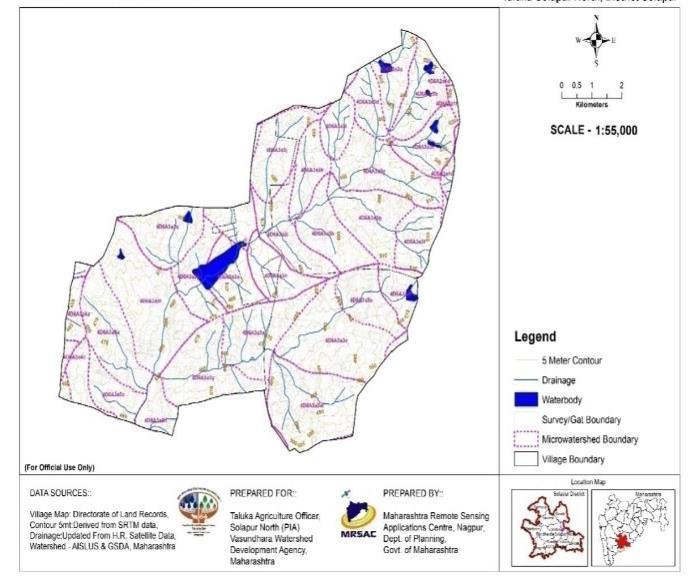
•ByGISSurveyincludingcontourmap,naturalstreamline map,waterdelineationmapgivinglandusedetails.
Akolekati village
Akolekati village is located in Solapur North Tehsil of Solapur district in Maharashtra, India. Akolekati is locatedat17.796028 Latitude and 75.8381345 Longitude. The climate of the village is tropical. During Summer, the humidity level is very high and in winter the climate is almostalwaysdry.Theunavailabilityofwaterinsummeris severe. The total geographical area of village is 1872hectares. Akolekati has a total population of 3,430 peoples.Thereareabout700housesinAkolekativillage.
Darfal village
DarfalvillageislocatedinSolapurNorthTehsilofSolapur district in Maharashtra, India. Darphal is locatedat17.7965°N,75.7946°E.Ithasanaverageelevation of11metres(36feet).Theclimateofthevillageistropical. DuringSummer,thehumiditylevelisveryhighandinwinter theclimateisalmostalwaysdry.Theunavailabilityofwater insummerissevere.Thetotalgeographicalareaofvillageis 3439hectares.Darfalhasatotalpopulationof7,106peoples. Thereareabout1,600housesinDarfalvillage.
Nannaj village
NannajvillageislocatedinSolapurNorthTehsilofSolapur districtinMaharashtra,India.Nannaj locatedat17.796028 Latitude and 75.8381345 Longitude. The climate of the villageistropical.DuringSummer,thehumiditylevelisvery high and in winter the climate is almost always dry. The unavailability of water in summer is severe. The total geographicalareaofvillageis3241hectares.Nannajhasa total population of 7585 peoples. There are about 1540housesinNannajvillage.
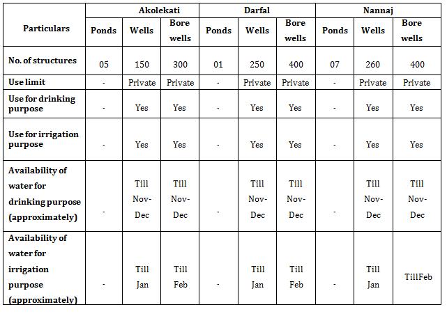
Watersheddevelopmentneedsbasicinformationaboutthe arealikegeographicalarea,population,averagerainfall,land undercultivation,Pondandcanal,Irrigationfacilityetc.
TableNo.1:Basicdetailsofstudiedarea
Details Akolekati Darfal Nannaj
Geographical area 1810.55ha 3162.20ha 2980.98ha
Population 3430 7106 7585
Average rainfall 542.2mm 542.2mm 542.2mm
Irrigation facility
Bore-well &dug wells, lake
Bore-well &dug wells,lake
Bore-well &dug wells, lake
TableNo.2:Existinggroundwaterstructuresinwatershed (TentativeData)
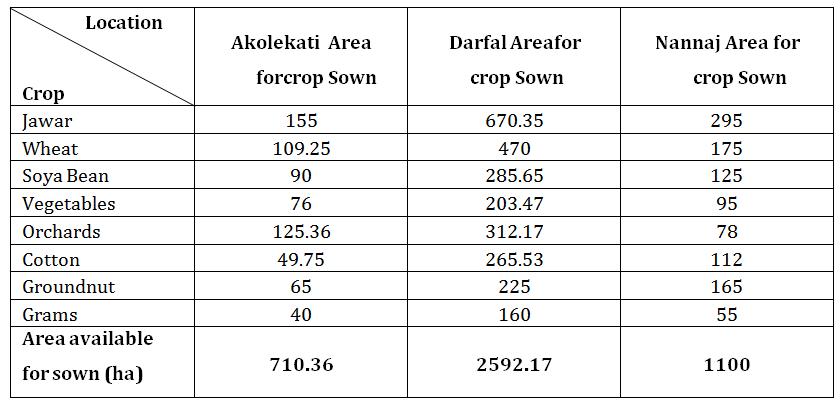
TableNo.3:Croppatternofstudyarea
International Research Journal of Engineering and Technology (IRJET) e-ISSN: 2395-0056
Volume: 11 Issue: 06 | Jun 2024 www.irjet.net p-ISSN: 2395-0072
Provision of treatment in the village watershed as per the IWMP isasfollows:
Theseareveryimportantstructuresinutilizingrainwaterfor recharging groundwater. They are also useful for soil conservationaswellaserosion.Rainfallinwatershedisnot sufficient but runoff goes waste due to insufficient no. of rainwaterharvestingstructures.
1)Theshortagewateravailabilityintheregionespeciallyin the post monsoon has resulted in the scarcity of water in NorthSolapur
2) The lack of water availability has also resulted in low agriculture production due to unavailability of water for irrigationpurposes.
3)Waterscarcityoveralongperiodhasledtoanincreasein migrationofpeopletotheurbanareasfortheemployment purpose.
4) Due to shortage of drinking water in summer season, supply of water through tankers becomes essential & also decreasethegroundwatertable.
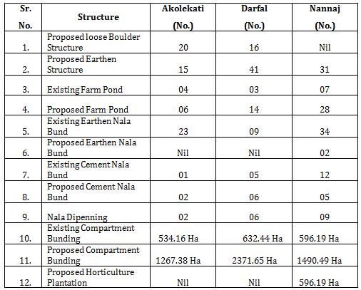
TableNo.4Existing&ProposedStructureunderIWMP inWatershedArea
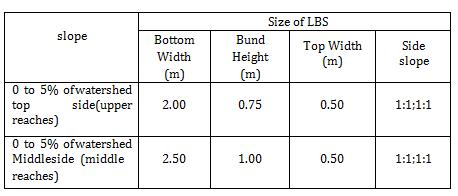
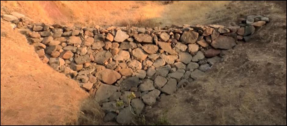
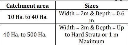
a) Loose Boulder Structure
Thesearesmallstructuresconstructedintheupperridgeof overagullyornalla,undulatingtopographyandwhererun offishigh.LBSismadeupoflooselyarrangedboulderssoas to arrest excess erosion and water loss during the rainy season.
TableNo.4SizeofLBS
b) Earthen Structure
Anearthenembankmentwhichisconstructedacrossthe gullyornala’scalledasearthenstructures
Purpose of Earthen Structure
1.Reducethevelocityofflowingwaterthroughthedrain.
2.Stopthewaterandpercolateitinthesoil.
3. Prevention of soil erosion caused by water and 4.Prevention of sedimentation in largereservoirs.
5.Plantationonthedownstreamsideofthedam.
6.Accumulationofsiltontheinsideofthedamincreasesthe catchmentarea.
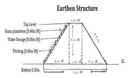
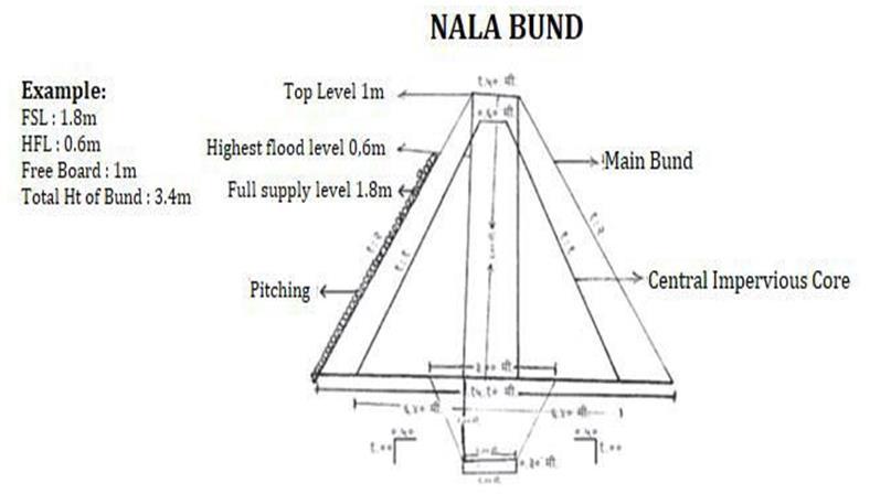
-2:Cross-SectionofEarthenStructure
International Research Journal of Engineering and Technology (IRJET) e-ISSN: 2395-0056
Volume: 11 Issue: 06 | Jun 2024 www.irjet.net p-ISSN: 2395-0072
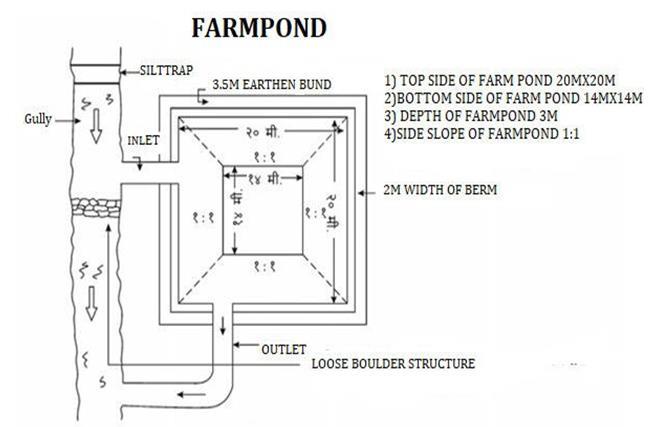
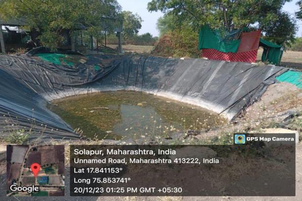
c) Farm Pond
FarmPondisadugoutstructurewithdefiniteshapeandsize havingproperinletandoutlet structuresforcollectingthe surface runoff flowing from the farm area. It is one of the mostimportantrainwaterharvestingstructuresconstructed atthelowestportionofthefarmarea.
Excavationdetails
a)Topdimensionsofpond=20mx20m
b)Middledimensionsofpond=17mx17m
c)Bottomdimensionsofpond=14mx14m
d)Depthofpond=3m
e)Sideslopetoexcavation=1:1
Sideearthenbunddetails
a)Topwidth=2m
b)Height=1.0m
c)Sideslope=1:1.25
Nala bunding is one of the important activities of the comprehensive watershed development programme in Maharashtra. Nala bunds are embankments constructed across the nala for storing runoff water, increasing water percolationandimprovingsoilmoistureregimes
1.PuddleTrench:Table5.showsthesizesofPuddle Trench.
Table 5. sizesofPuddleTrench.
2.GorgePit:Table6showsthesizesofGorgePit.
Table6.sizesofGorgePit.
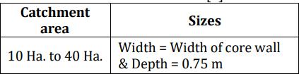
3.Corewall:
Height=Uptohighestfloodlevel
Width=0.6m
Sideslopes=1:1
4.Spillway:
Lengthofspillway= BasewidthatHFL+24 +10
BasewidthatHFL
Slope=1:1
Maximumlengthallowedforspillwayis30m.
If the Hard murum is not available for foundation
International Research Journal of Engineering and Technology (IRJET) e-ISSN: 2395-0056
Volume: 11 Issue: 06 | Jun 2024 www.irjet.net p-ISSN: 2395-0072
then take a 0.6 m width so as to avoiderosion of spillway.
Construct a header wall of height 0.5 m on downstreamsideofspillwaywall.
5.StonePitching:
Thethicknessoftherubblepitchingshouldbekept between 0.20 m to 0.25 m with 0.15 mthick murumbedding&doneuptoHFL
e) Cement Nala Bund
Acementnalabund(CNB)isabund/obstructionacrossthe nala or stream constructed by using cement concrete to obstructandstoretheflowingwater.Cementnalabundsare alsoreferredtoafewothernames pukkabund,checkdam, weir.
Designdetails:
Detailsspecificationofcheckdam sideslopei)u/s=1:1ii)d/s=1:5
TopWidth=0.5m
BaseWidth=10m
Height=1.5m
Depthoffoundation=1.5m
Lengthofcheckdam=15m
freeboard=1m
BedWidthofDrain=10m
Remove the silt from the nala & deepening the bed of the nala.Youmustremoveitusingpropermachines&following scientifictechniques.Useapokelandexcavatormachineof 210horsepower,becausePokelandmachine have18to20 feetlongboomhence,itcaneasilyliftthesiltfromthebed& pileitonthebanksthis resultinexcellentquality&speed completionofworksouseapokeland
Compartmentalbundingmeanstheentirefieldisdividedinto smallcompartmentswithpredeterminedsizetoretainthe rain water where it falls and arrest soil erosion. Compartmental bunding conserves the rainwater in situ, recharges soil profile uniformly, reduces runoff, soiland nutrient lossesand increases crop yields ona sustainable basis. This technology is simple and low cost and can be adoptedbythefarmerseasilyinthemediumtodeepblack soilsintheregion.
Horticulture Sector plays an important role in the developmentofwatershedareabythe conceptofdryland horticulture. The growing of suitable perennial dry land horticultural crops not only brings soil and water conservation insitu, but also makes best use of available moisture resulting in increase in the returns. This creates an eco-friendly environment inadditionwithgenerationof rural employmentopportunities.Theplantingmaterialsof suitablehorticulturalcropslikefruit,flowersandperennial Vegetable crops are supplied andplanted in the identified beneficiarieslands.
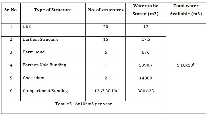
Table 7.CapacityofProposedWatershedStructureof Akolekati
International Research Journal of Engineering and Technology (IRJET) e-ISSN: 2395-0056
Volume: 11 Issue: 06 | Jun 2024 www.irjet.net p-ISSN: 2395-0072
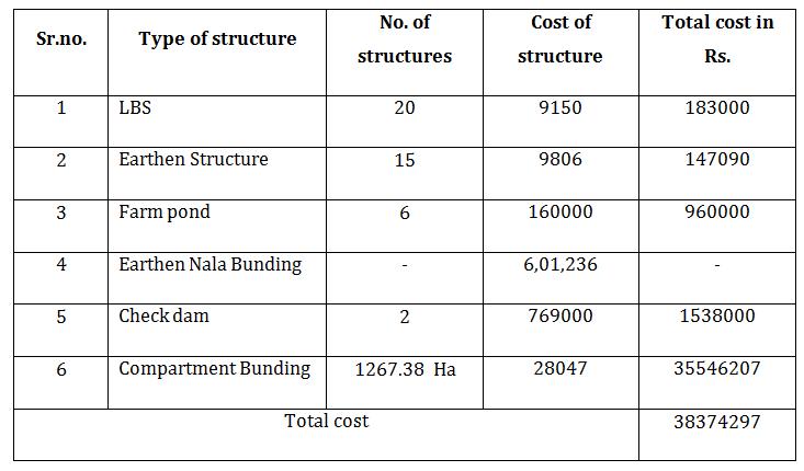
Table 8.CostofProposedWatershedStructureof Akolekati
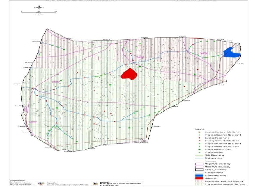
Map No. 2 MapShowingExisting&ProposedWatershed StructureOfAkolekati
A) Annual Water Requirement for demand of Domestic & Animal
DomesticRequirement=106926.75cub.m
AnimalRequirement=7491.625cub.m.
Totalwaterrequirement=1.14x10⁵cub....m.
B) Cost of water per liters
Total Capacity of Proposed watershed structure = 516000000Liters
Totalcostofwatershedtechniques=Rs 38374297
Costofwaterperliters=38374297/516000000
Costofwaterperliters=Rs.0.074/lit
DARFAL
Table 9.CapacityofProposedWatershedStructureof Darfal
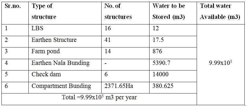
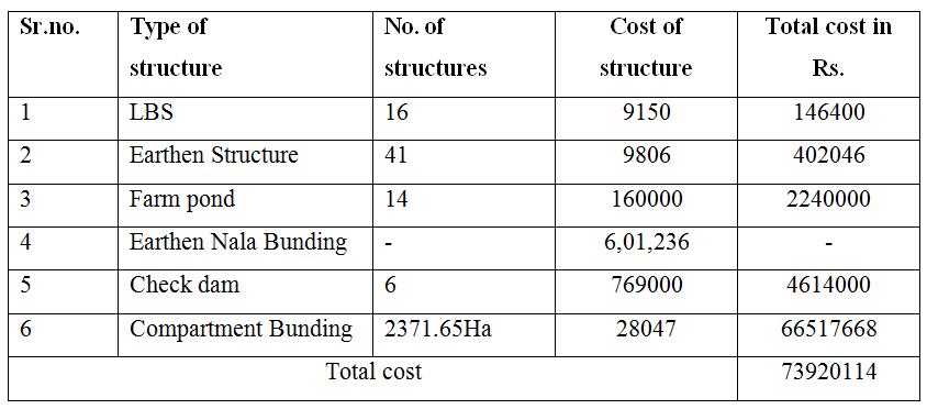
Table 10 CostofProposedWatershedStructureof Darfal
A) Annual Water Requirement for demand of Domestic & Animal
DomesticRequirement=221492.950cub.m.
AnimalRequirement=25769cub.m
Totalwaterrequirement=2.47x10⁵cub.m.
B) Cost of water per liters
Total Capacity of Proposed watershed structure = 999000000Liters
Totalcostofwatershedtechniques=Rs.73920114
Costofwaterperliters=73920114/999000000
Costofwaterperliters=Rs.0.073/lit
© 2024, IRJET | Impact Factor value: 8.226 | ISO 9001:2008
|
International Research Journal of Engineering and Technology (IRJET) e-ISSN: 2395-0056
Volume: 11 Issue: 06 | Jun 2024 www.irjet.net p-ISSN: 2395-0072
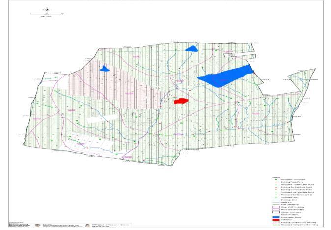
Map No. 3 MapShowingExisting&ProposedWatershed StructureOfDarfal
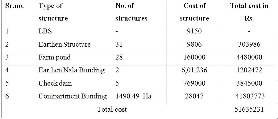
Table 11.CapacityofProposedWatershedStructureof Nannaj
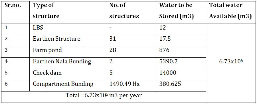
Table 12. CostofProposedWatershedStructureofNannaj
A) Annual Water Requirement for demand of Domestic & Animal
DomesticRequirement=236490.8cub.m.
AnimalRequirement=38921.045cub.m
Totalwaterrequirement=2.75x10⁵ cub.m.
B) Cost of water per liters
Total Capacity of Proposed watershed structure = 673000000Liters
Totalcostofwatershedtechniques=Rs.51635231
Costofwaterperliters=51635231/673000000
Costofwaterperliters=Rs.0.076/lit
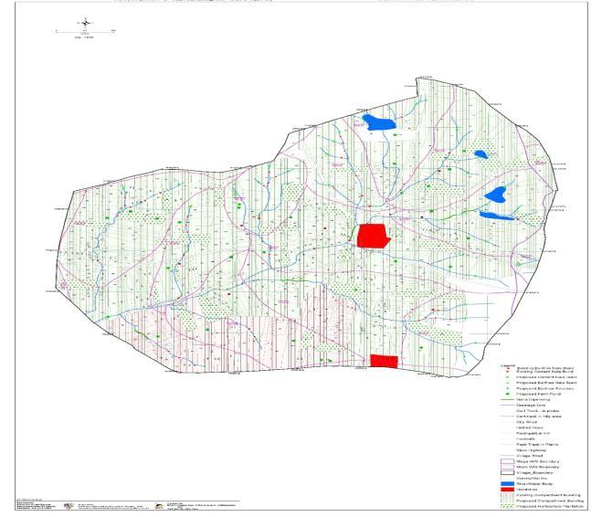
Map No. 3 MapShowingExisting&ProposedWatershed Structureof Nannaj
TheBenefitCostRatio(BCR)hasbeencalculatedforAkolekati, Darfal&Nannaj.Atimeseriesstatementispreparedboth,the costincurredandbenefitsachievedduringthesameperiod. TheyarethensummedupandtheBCRiscalculatedasper theformulagivenbelow
BCR= Total benefit/ Total cost
Table 13. BCRofwatershedstructure
In North Solapur the demand for water is going on increasing with the increase in population. So efforts are madetoincreaserechargingofwaterbyvariouswaterand soilconservationstructures.
1)Perennialsourceofwaterisnotavailable.Ifwatershed developmenttechniquesare implemented,it will resultin increase in the living standard and economic condition ofpeopleofinthesevillages.
International Research Journal of Engineering and Technology (IRJET) e-ISSN: 2395-0056
Volume: 11 Issue: 06 | Jun 2024 www.irjet.net p-ISSN: 2395-0072
2)Availabilityofwaterforrechargeveryless.wateroftotal precipitation (542 mm Avg. Precipitation) is available for artificial recharge. It is found that 85 % of this available watercanberechargedinwatershedarea.
3) For watershed development project runoff is very importantfactor.Itiseasytomakeriseinwatertable,dueto check to the flow of water or runoff. Runoff occur in nallas/streams.
4) Watershed management project can effectively solve problemofdrinkingwater.
5)VariouswatershedmeasureslikeRWH,farmpond,check dam, vanrai bandhara, should be implemented to cope up withthedroughtconditions.
6) Maintenance programme for water storage structure shouldbedoneregularlylikeremovingsiltinthelake,wells and check dam it will result in increase water storage capacityofabovestructuresandincreasegroundwatertable.
7)Watersheddevelopmentprojectiseffectivefordecreasing demand of water from other resources and becomes self dependentfromwatersupplypointofview.
1) Government of Maharashtra, Dept. of Agriculture, ComprehensiveDistrictAgriculturePlan.
2) Government of India, Ministry Of Water Resources, Central ground Water Board, Ground Water Information, SolapurDistrict,Maharashtra.
3) District Agricultural Office, Solapur Maharashtra (PIA IWMP-21)
4)GovernmentofIndia,CommonGuidelinesforWatershed Developmentprojects,2008,NewDelhi,India.
5)B.A.Shiferaw,R.V.Reddy,S.P.WaniandG.D.Nageswara Rao, ‘Watershed management and farmer conservation investments in the semi-arid tropics of India: Analysis of determinants of resource use decisions and land productivity benefits’ , Working Paper Series no. 16, Patancheru, Andhra Pradesh, India: International Crops ResearchInstitutefortheSemi-AridTropics,2003,1-24.
6)B.Mishra,‘Asuccessfulcaseofparticipatorywatershed management at Ralegansiddhi village in district Ahmadnagar, Maharastra, India’, Case studies of people's participation in watershed management in Asia (GCP/RAS/161/NET),FAOCorporateDocumentRepository, 1996.
7) B. Sada Siva, ‘Experience and case study on impact evaluationofwatersheddevelopment:farmpond–ameans
forpovertyreduction’,Seminaronwatersheddevelopment, DHANfoundation,2006.
8)B.Shivarudrappa,‘FarmpondforsustainablelivelihoodacasestudyofPampanur’ ,Seminaronruraldevelopment, CRIDA,Hyderabad,April2009.