
International Research Journal of Engineering and Technology (IRJET) e-ISSN: 2395-0056 p-ISSN: 2395-0072

Volume: 11 Issue: 05 | May 2024 www.irjet.net

International Research Journal of Engineering and Technology (IRJET) e-ISSN: 2395-0056 p-ISSN: 2395-0072
Volume: 11 Issue: 05 | May 2024 www.irjet.net
1,2,3,4 UG Student, Department of Civil Engineering, Jawaharlal College of Engineering and Technology, Ottapalam, Kerala, India
5 AssistantProfessor, Department of Civil Engineering, Jawaharlal College of Engineering and Technology, Ottapalam, Kerala, India
Abstract - This project proposes a pioneering solution to theubiquitousproblemofpotholes withthe developmentofa sensor system. Potholes present a persistent challenge to road infrastructure, leading to vehicle damage and jeopardizing road safety. Leveraging the precision of Ultrasonic Sensors, this project introduces an efficient method for real-time detection of potholes by identifying variations in the road surface. Integration with GPS technology ensures accurate geospatial coordinates, enabling the creation of a dynamic map that visualizes the locationand severity of potholes. The literature review underscores the limitations ofconventional pothole detection methods and highlights the potential of sensor-based technologies. Our approach involves a systematic integration of Ultrasonic Sensors and GPS devices, offering a robust and cost-effective solution for proactive road maintenance.The projectnot onlyaimstoenhanceroadsafety butalsoexploresthefeasibilityofemployingdataanalyticsfor predicting and preventing future pothole formation. This project'ssignificanceliesinitspotentialtorevolutionizeroad maintenancepractices,reducerepaircosts,andcontribute to the development of smarter and safer urban environments. The outcomes of this project have far-reaching implications for transportation management, urban planning, and the realization of resilient and sustainable infrastructure networks.
Key Words: IoT, NodeMCU, Arduino UNO Microcontroller, Voltage Regulator Module, Ultrasonic Sensor,
In the intricate tapestry of modern urban infrastructure, roads constitute a vital framework that underpins the seamlessfunctioningofsocieties.Roadsaretheconduitsof progress, enabling the efficient flow of commerce, the commuteofmillions,andtheconnectivitythatknitscities and regions together. However, the integrity of these thoroughfares is constantly challenged by the relentless forcesofwearandtear,weather-inducedstresses,andthe sheer weight of vehicular traffic. Among the myriad challenges that afflict roadways, the presence of potholes standsoutasbothaubiquitousandperniciousissue.These disruptions in the road surface not only exact a toll on

vehicles but also pose a significant threat to the safety of motoristsandpedestriansalike.
Againstthisbackdrop,ourprojectembarksonamissionto tackle the pervasive problem of potholes through the integrationofcutting-edgetechnologies.PotholeDetection and Mapping Using Ultrasonic Sensor and GPS is an endeavour that seeks to leverage the capabilities of UltrasonicSensorsintandemwithGPStechnologytocreate a comprehensive system for the real-time detection and mappingofpotholes.Thisprojectrepresentsaconvergence ofinnovation,addressingthechallengesposedbypotholes not merely as a localized issue but as a systemic concern withimplicationsforsafety,infrastructuremaintenance,and urbanplanning.
Themaintenanceofroadinfrastructurehasalwaysbeena criticalaspectofurbandevelopmentandcivicresponsibility. Potholes,thoseinsidiousdepressionsintheroadsurface,are born from a complex interplay of factors, including water infiltration, traffic-induced stress, and the cyclical freezethawcyclesthatafflictroadsincolderclimates.Despitethe advances in construction materials and engineering techniques, potholes persist as a recurring menace that demandscontinualattention.
Traditional methods of pothole detection, often reliant on visual inspections by road maintenance crews, are timeconsuming, labour-intensive, and subject to human error. The consequences of delayed detection and repair are manifold,rangingfromincreasedvehicularrepaircosts to heightenedrisksofaccidentsandinjuries.Itisagainstthis backdropthattheneedforanautomated,technology-driven solution becomes evident a solution that can identify potholes swiftly and accurately, enabling a proactive approachtoroadmaintenance.
Themethodologyinvolvesintegratingultrasonicsensorsfor real-time pothole detection, employing distance measurement principles. The ultrasonic sensor data is processedthroughamicrocontrollertoidentifyanomalies indicative of potholes. Concurrently, GPS technology is utilizedtoprovideaccurategeolocationcoordinatesforeach detectedpothole.Theintegrationofthesetechnologies

International Research Journal of Engineering and Technology (IRJET) e-ISSN: 2395-0056 p-ISSN: 2395-0072
Volume: 11 Issue: 05 | May 2024 www.irjet.net
forms a cohesive system, ensuring precise mapping of potholelocations.Theprojectemploysprototyping,testing, and iterative refinement to validate the accuracy and efficiencyofthesystem.Theuserinterfaceisdesignedfor intuitive data visualization, enhancing the accessibility of pothole information for effective urban infrastructure management.
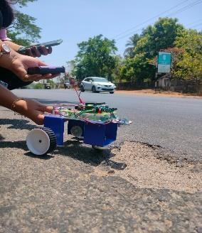
Figure 1 shows the block diagram of the system. Input, output, and a microcontroller board make up the system. The microcontroller, which is also attached to the output units,isusedinconjunctionwiththemicrocontroller'sserial monitorandBlynkAppinventor-basedmobileapplication attached to a Bluetooth module to display the viewer digitally converted data. Sensors pass analog data to the microcontroller Arduino UNO. The Arduino converts that datatoareadabledigitalformatandpassesittothemobile applicationthroughtheBluetoothmodule.ThebelowFigure 1showsthecompleteblockdiagramofthepresentproject whichincludesthecontrollerunit,powersupply,Ultrasonic sensor,GPSmoduleandIOT.Inthis,wepresentthetheoryon real time monitoring of water quality in IoT environment. The overall block diagram of the proposed method is explained.Eachandeveryblockofthesystemisexplainedin detail.HeretheultrasonicsensorandGPSisconnectedtothe microcontroller. The microcontroller then checks the receivedvalueandcomparesitwiththethresholdvalueand themessageissent.


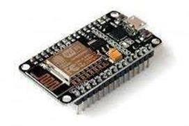
TheNodeMCUisaversatileopen-sourcedevelopmentboard based on the ESP8266 microcontroller. It integrates Wi-Fi connectivity, enabling seamless communication with networks and the internet, making it a go-to choice for Internet of Things (IoT) projects. With its Lua-based scriptinglanguageandcompatibilitywiththeArduinoIDE,it offersauser-friendlyprogrammingenvironmentsuitablefor bothbeginnersandexperienceddevelopers.Equippedwith GPIO pins, it allows interfacing with various sensors, actuators,andotherperipherals,facilitatingawiderangeof applications. Its compact size, low cost, and extensive community support have contributed to its widespread adoptioninDIYprojects,homeautomationsystems,remote monitoring solutions, and prototyping wireless devices. Additionally, the NodeMCU's capabilities extend beyond simple IoT applications, with enthusiasts leveraging its features for projects ranging from weather stations and smart appliances to data logging and robotics, making it a versatileplatformforexploringandimplementingconnected solutions.


A GPS module is a compact electronic device that integrates a Global Positioning System (GPS) receiver to provideaccuratelocationandtiminginformation.Itreceives signals from a network of satellites orbiting Earth to determineitsprecisegeographiccoordinates,altitude,speed, and time. GPS modules typically consist of a GPS receiver chip,anantennaforreceivingsatellitesignals,andsupporting circuitryforprocessingandoutputtingthelocationdata. Thesemodulesarecommonlyusedinvariousapplications, including navigation systems, vehicle tracking, asset monitoring, outdoor recreational devices, and time synchronization.Theyofferhighaccuracyandreliabilityin determining location, making them indispensable tools in industriessuch as transportation,logistics,surveying,and agriculture. GPS modulescan communicatewith
International Research Journal of Engineering and Technology (IRJET) e-ISSN: 2395-0056 p-ISSN: 2395-0072
Volume: 11 Issue: 05 | May 2024 www.irjet.net
microcontrollers or other devices through serial communication interfaces like UART or SPI, allowing for seamless integration into electronic systems. With advancementsintechnology,modernGPSmodulesmayalso supportadditionalsatellitesystemslikeGLONASS,Galileo,or BeiDou, enhancing positioning accuracy and reliability, especiallyinchallengingenvironments.
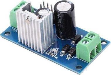
Thevoltageregulatorensuresastableandconsistentsupply ofvoltagetosensitivecomponentslikethemicrocontroller, GPSmodule,andultrasonic sensor.Asthese devicesoften operatewithinspecificvoltageranges,thevoltageregulator prevents potential damage from voltage fluctuations. By maintaining a steady voltage output, the regulator guarantees the reliable and efficient performance of the electronic components. This ensures the accuracy of data acquisition, processing, and communication within the system,contributingtotheoverallreliabilityandlongevity ofthepotholedetectionandmappingsolution.
Theultrasonicsensorisacriticalcomponentintheproject. Functioning as the primary detection mechanism, the ultrasonicsensormeasuresthetimetakenforemittedsound wavestoreturnafterbouncingoffroadsurfaces.Variances inthisreturntimeindicateirregularities,suchaspotholes. Thesensorcaptures real-timedata,enablingaccurate and immediateidentificationofroadanomalies.Thisdataisthen processed by the system, contributing to the creation of a dynamicmappinpointingthepreciselocationsofdetected potholes. The ultrasonic sensor's role is central to the project's goal of enhancing road safety and infrastructure maintenance.
The integration of IoT (Internet of Things) in the project enablesremotemonitoringanddataaccessibility.Through IoT, the system can transmit real-time pothole data to a centralized server or cloud platform. This connectivity allowsstakeholders,includingmaintenancecrewsandcity planners, to access dynamic maps and receive alerts on pothole locations. Additionally, IoT facilitates seamless communication between devices, enhancing the overall responsivenessandadaptabilityofthesystem.Byleveraging IoTcapabilities,theprojectextendsitsreachbeyondlocal monitoring,contributingtoamoreconnectedandefficient approachtourbaninfrastructuremanagement.
8-IoTModule
2.7 Blynk App
The Blynk app serves as a user-friendly interface in the "PotholeDetectionandMappingusingUltrasonicSensorand GPS"project.IntegratedwiththeIoTplatform,Blynkallows users to visualize real-time pothole data, providing a dynamicandaccessiblemapofdetectedanomalies.Through theapp,stakeholderscanreceiveinstantalerts,contributing to timely maintenance responses. Blynk enhances user interaction by offering a customizable interface, enabling seamless control and monitoring of the pothole detection system.ItsversatilityandeaseofintegrationmaketheBlynk appa valuablecomponent,ensuringefficientcommunication and enhancing the accessibility of critical information for urbaninfrastructuremanagement.
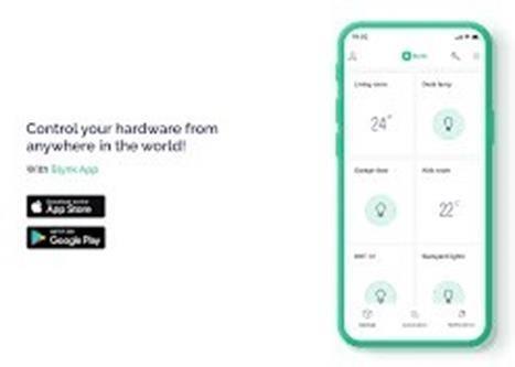
Fig. 9- BlynkAppInterface
e-ISSN: 2395-0056 p-ISSN: 2395-0072
Theproject'sworkingprocessinvolvesasystematicflowof operations to achieve accurate pothole detection and mapping.
Ultrasonic sensors are strategically placed on a mobile platform, continuously emitting high-frequency sound waves. These waves interact with the road surface, and variations in return times are analyzed to identify irregularities,suchaspotholes.
3.2
The gathered ultrasonic sensor data is fed into a microcontroller.Thiscentralprocessingunitinterpretsthe data, identifying patterns indicative of potholes based on distancemeasurementsandpredefinedcriteria.
3.3
Simultaneously,aGPSmodulecapturesprecisegeolocation coordinates,providingaccuratespatialinformationrelated tothedetectedpotholes.
3.4
The microcontroller integrates the ultrasonic sensor data with GPS coordinates, creating a comprehensive dataset. ThisinformationisthenvisualizedthroughtheBlynkapp, offering a user-friendly interface that displays real-time potholelocationsanddepth.
Stakeholders can interact with the Blynk app, receiving instantalertsandshowingthelatitude,longitudeanddepth ofdetectedpotholes. Thisenhancessituational awareness andaidsinpromptmaintenanceresponses.
The system can store historical data, enabling further analysis of pothole patterns over time. This stored informationcontributestopredictivemaintenancestrategies andefficienturbaninfrastructuremanagement.
2395-0072 Volume: 11 Issue: 05 | May 2024 www.irjet.net
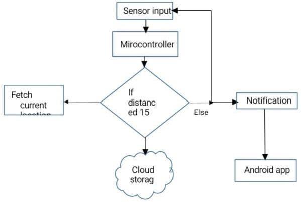
Byorchestratingthestepsasexplainedaboveandshownin figure 10, the project achieves a seamless and efficient processforpotholedetectionandmapping,contributingto enhancedroadsafetyandoptimizedmaintenancepractices.
Thesensordesignedformeasuringandmappingpotholes underwent rigorous testing in real-world conditions. The results indicate high level of accuracy and reliability in detecting and characterizing potholes on road surfaces. Thesensor’sabilitytomappotholesinreal-timeprovided to be invaluable for infrastructure maintenance and planning.Byprovidingpreciselocationdata anddepthof potholes, road authorities can prioritize repair efforts efficiently,ultimatelyimprovingroadsafetyandreducing maintenance costs. The sensor is compatible with GIS which facilitates seamless integration into existing infrastructure systems. This ensures easy adoption by municipalitiesandroadmaintenanceagencies.
Moreover, the sensor’s low power consumption and wireless connectivity allow for autonomous operation, minimizing the need for frequent maintenance and manual intervention. By providing timely and precise information about road surface conditions the sensor empowersroadauthoritiestomakedata-drivendecisions regarding maintenance, prioritization and resource allocation. This proactive approach not only enhances road safety but also prolongs the lifespan of road networks, ultimately benefiting both commuters and taxpayers.
After implementing proposed Pothole Detection and MappingSystemwhichovercomestwomajorproblems
thatconcernedthepeoplethemostandwhichleads tofrequentaccidentsanddamageofvehiclesthatis automatic detection of the potholes with their intensity and mapping it on map. The proposed work is more economical as it uses a low-cost ultrasonicsensorandaGPSmodule.
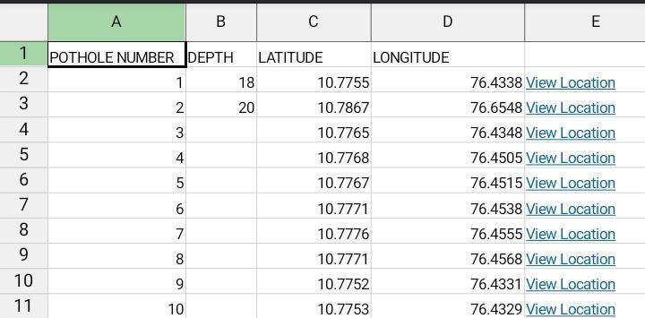
Weconnectedthesensorto theBlynkapp, whichis a flexible platform for Internet of Things apps, to provide simple access and visualisation of the gathered data. During our on-road testing, we created a separate dashboard to show the depth, latitude,andlongitudeofpotholesfoundbyutilising Blynk's customisable features and user-friendly interface. This dynamic dashboard facilitates realtimeremotemonitoringofpotholedata.
Our programming architecture makes it easier to transfer processed data to other platforms like Excel spreadsheets for additional sharing and customisation.Stakeholdersmayquicklyaccessand modifythedatatosuittheirownneedsbyexporting ittoExcelfiles.
International Research Journal of Engineering and Technology (IRJET) e-ISSN: 2395-0056 p-ISSN: 2395-0072
Volume: 11 Issue: 05 | May 2024 www.irjet.net
Overall, the sensor represents a promising solution to the perennialproblemofpotholesandunderscoresthepotential oftechnologyintransformingtransportationinfrastructure managementforthebetter.
Inconclusion,theproject"PotholeDetectionandMapping using Ultrasonic Sensor and GPS" represents a pioneering endeavorintherealmofsmartinfrastructuremanagement. The seamless integration of ultrasonic sensors and GPS technologyhasresultedinarobustsystemcapableofrealtime pothole detection and precise mapping. Through the user-friendly Blynk app interface, stakeholders gain immediate access to dynamic maps displaying accurate locationsofdetectedpotholes,fosteringtimelyintervention and maintenance. This innovative solution not only addresses the immediate challenge of road safety by identifying potential hazards but also contributes to a proactiveanddata-drivenapproachtourbaninfrastructure management. The project's success lies in its ability to synergizemultipletechnologies fromultrasonicsensors for accurate detection to GPS for precise geolocation creatingacomprehensiveandaccessiblesystem.
Furthermore, the integration of IoT capabilities expands the project's horizons, enabling remote monitoring and data accessibility. This connectivity allows for the seamless transmission of real-time pothole data to a centralized platform, fostering a more connected and efficientapproachtoinfrastructuremanagement.
The implications of this project extend beyond the technical realm, impacting the broader domain of urban planning, transportation, and safety. By providing stakeholders with actionable insights and facilitating a swift response to road irregularities, the project contributes to the creation of smarter, safer, and more resilientcities.
As cities evolve towards becoming more connected and technologicallyadvanced,solutionsliketheonepresentedin this project become imperative for sustainable urban development. With its successful implementation, this project stands as a testament to the potential of technology in enhancing the safety and efficiency of our urbanroadnetworks.
[1] Kim, Taehyeong, and Seung-Ki Ryu. "Review and analysis of pothole detection methods." Journal of Emerging Trends in Computing and Information Sciences 5, no. 8(2014):603-608.
[2] Laohaprapanon, Suriyan, Kimberly Ortleb, and GauravSood. "Street Sense: Learning from Google Street View."arXivpreprintarXiv:1807.06075(2018).
[3] Patra, Suvam, Pranjal Maheshwari, Shashank Yadav, SubhashisBanerjee,andChetanArora."Ajoint3d-2dbased method for free space detection on roads." In 2018 IEEE Winter Conference on Applications of Computer Vision (WACV),pp.643-652.IEEE,2018.
[4] Wang, Huaijun, Na Huo, Junhuai Li, Kan Wang, and Zhixiao Wang. "A Road Quality Detection Method Based on the Mahalanobis-Taguchi System." IEEE Access 6 (2018): 29078-29087.
[5] El-Wakeel, Amr S., AboelmagdNoureldin, Hossam S. Hassanein, and Nizar Zorba. "iDriveSense: Dynamic Route Planning Involving Roads Quality Information." In 2018 IEEEGlobal CommunicationsConference(GLOBECOM), pp. 1-6.IEEE,2018.
[6] F. Kalim, J. P. Jeong and M. U. Ilyas, "CRATER: A Crowd Sensing Application to Estimate Road Conditions," in IEEE Access,vol.4,pp.8317-8326,2016.
[7] Pan, Yifan, Xianfeng Zhang, Guido Cervone, and Liping Yang. "Detection of asphalt pavement potholes and cracks based on the unmanned aerial vehicle multispectral imagery." IEEE Journal of Selected Topics in Applied Earth ObservationsandRemoteSensing11,no.10(2018):37013712.
[8]M.M.Garcillanosa,J.M.L.Pacheco,R.E.ReyesandJ.J.P. San Juan, "Smart Detection and Reporting of Potholes via Image-Processing using Raspberry-Pi Microcontroller," 2018 10th International Conference on Knowledge and SmartTechnology(KST),ChiangMai,2018,pp.191-195.