
International Research Journal of Engineering and Technology (IRJET) e-ISSN: 2395-0056
Volume: 11 Issue: 04 | Apr 2024 www.irjet.net p-ISSN: 2395-0072
International Research Journal of Engineering and Technology (IRJET) e-ISSN: 2395-0056
Volume: 11 Issue: 04 | Apr 2024 www.irjet.net p-ISSN: 2395-0072
Rahul Kapase1 , Mrunmai Panchwadkar2 , Ajay Kawathe3 , Suraj Landge4 ,Ajinkya Gore5 Aniket Malusare6
1Assistant Professor Civil Engineering, RMD Sinhgad School of Engineering, Warje, Pune, Maharashtra, India
2Student Civil Engineering, RMD Sinhgad School of Engineering, Warje, Pune, Maharashtra, India
3Student Civil Engineering, RMD Sinhgad School of Engineering, Warje, Pune, Maharashtra, India
4Student Civil Engineering, RMD Sinhgad School of Engineering, Warje, Pune, Maharashtra, India
5Student Civil Engineering, RMD Sinhgad School of Engineering, Warje, Pune, Maharashtra, India
6Student Civil Engineering, RMD Sinhgad School of Engineering, Warje, Pune, Maharashtra, India
Abstract - Flooding isa recurring naturalhazard thatposes significant risks to human lives, infrastructure, and the environment. Western Maharashtra, a region in India, has witnessed a history of devastating floods, leading to substantial socioeconomic losses. This study aims to provide a comprehensive flood assessment of the Western Maharashtra region, incorporating various factors such as rainfall patterns, hydrological characteristics, land use changes, and existing flood mitigation measures. The research employs a multidisciplinary approach, integrating remote sensing and GIS techniqueswithhydrologicalmodellingandstatisticalanalysis. Historical rainfall data from meteorological stations and satellite-derivedprecipitationestimatesareanalysedtoidentify temporal and spatial patterns of extreme precipitation events. Hydrological characteristics, including river networks, catchment areas and flow rates are analysed using digital elevation models and hydrological modelling tools.
Key Words: flood assessment, Western Maharashtra, rainfall patterns, hydrological characteristics, land use changes, flood mitigation, remote sensing, GIS, hydrological modelling, risk management.
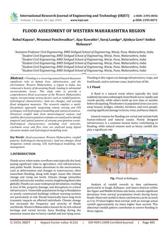
Floodsoccurwhenwateroverflowsontotypicallydryland, posing significant risks to agriculture, civil infrastructure, and public health. Human alterations to the environment, such as deforestation and changes in watercourses, often exacerbate flooding, along with larger issues like climate change and rising sea levels. Climate change intensifies rainfallandextremeweatherevents,heighteningfloodrisks globally.Floodscancausewidespreaddevastation,resulting inlossoflife,propertydamage,anddisruptionstocritical infrastructure.Vulnerablepopulationslivinginfloodplains or poorly constructed buildings without warning systems areparticularlyatrisk.Floodshistoricallyleavelong-term traumatic impacts on affected individuals. Climate change has increased the frequency and severity of floods worldwide.WesternMaharashtra,knownforitsrichcultural heritage and varied terrain, faces flooding during the monsoonseasonduetoheavyrainfallandlow-lyingareas.
Floodinginthisregioncandamageinfrastructure,crops,and livelihoods,andinextremecases,leadtolossoflife.
A flood is a natural event where typically dry land suddenlybecomessubmerged.Somefloodsoccurrapidlyand recedequickly,whileothersbuildupoverdaysormonths beforedissipating.Floodwatersinpopulatedareascancarry awayhouses,bridges,vehicles,furniture,andevenpeople, causingsignificantdamagetofarms,trees,andheavyobjects.
Generalreasonsforfloodingarevariedandincludeboth human-induced and natural causes. Poorly designed infrastructure is a common human factor contributing to flooding, while natural reasons such as heavy rainfall also playasignificantrole.
Analysis of rainfall records in dam catchments, particularlyinSangli,Kolhapur,andSataradistrictswithin theUpperandMiddleKrishnasub-basin,revealssignificant deviations from normal precipitation levels during heavy floods.Observedrainfallinthesecatchmentscanbeasmuch as5to19timeshigherthannormal,withanaverageactual rainfall approximately six times higher than normal. This abnormal rainfall patterncontributestoseverefloodingin theseregions.
International Research Journal of Engineering and Technology (IRJET) e-ISSN: 2395-0056
Volume: 11 Issue: 04 | Apr 2024 www.irjet.net p-ISSN: 2395-0072
The average actual rainfall in these catchments was approximately six times higher than the normal rainfall, leadingtoabnormalfloodingdownstream.
floodtodownstreamareas.X-AxisY-Axis2015979.9 20161667.720171727.120181834.920193235.22020 25002021.
Analysis of rainfall records in the free catchments of Sangli, Kolhapur, and Satara districts revealed significant deviationsfromnormalprecipitationlevels.Duringthepeak 18-dayperiod,rainfallwasabout1.6timeshigherthanthe previous 56 days. Actual rainfall during this event ranged from 13 to 29 times the normal amount, with an overall observedrainfallapproximately18timeshigherthannormal. This abnormal rainfall exacerbated floods in Sangli and Kolhapurdistricts.Regardingrunoff,about6630Mm3(234 TMC)yieldwasgeneratedinalldamsupstreamofthestate border.Ofthis,2949Mm3(104TMC)couldbeabsorbedin dams,whiletheremaining6381Mm3(130TMC)hadtobe released downstream, generating 5663 Mm3 (200 TMC) runoff. Out of the total yield of 12,293 Mm3 (434 TMC) generated at the state border, only 2949 Mm3 (104 TMC) could be effectively mitigated. This led to a serious flood situation in the Krishna Valley in Maharashtraandfurther intoKarnataka.
DuringtheheavyrainspellinAugust2019,manystationsin Kolhapur district and the western part of Satara district exceededtheirpreviousrecordof7daysrainfall.
Table -1 Reachwisecrosssectionsmodeled
Pancha
This highlights the following issues contributing to flooding:
1.Inadequatelanddrainagesystemsinurbanareas:
a) Poorly planned primary drainage systems result in stagnant floods throughout the city instead of efficient disposal.
b) Secondary drainage systems must maintain clear pathways for storm water to drain into natural watercourses,preventingblockagesandfacilitatingquick drainage.
c) Tertiary drainage systems should effectively channel floodwaterfromtributariesandwatercoursesintomain riverchannels.However,encroachmentsinrivercourses exacerbate flooding due to backwater effects and poor drainage.
2. Lackoffloodabsorptioncapabilitiesinreservoirplanning:
a) Reservoirs are often not designed to absorb excess floodwater, with dead storage intended for silt accumulationandlivestoragefullyutilized.
b) Reservoiroperationschedulesprioritizefullstorageby theendofthemonsoon,withoutconsiderationforflood mitigation.
c) Ungated spillways and dams lacking manual control furtherexacerbateflooding.
3.Othercontributingfactors:
Debrisaccumulationonweirs,bridgepiers,andparapets obstructs flow, temporarily raising flood levels. Regular maintenance of these structures is essential to prevent blockages.
1) Tostudythedifferentreasonforfloodsituation
2) TofindreasonsforthewesternMaharashtraflood
3) Tofindapossiblesolutioninavoidanceoffloodsituation inwesternMaharashtra
4) TostudylandtopographyusingGIStechnique.
Analyse topography of western Maharashtra using variousmapsonGIS.Tocarryoutvariousoperationsonthe Toposheetmosaicimageandinsertvariousinformationso thatthefinalprojectiswellequippedwithallthenecessary datalikeelevation,contours,GISLayering,etc.
International Research Journal of Engineering and Technology (IRJET) e-ISSN: 2395-0056
Volume: 11 Issue: 04 | Apr 2024 www.irjet.net p-ISSN: 2395-0072
ExamineclimaticconditionofwesternMaharashtrafor pastyears.Maharashtraexperiencesatropicalwetanddry climatewithhot,rainy,andcoldweatherseasons.Someareas moreinlandexperienceahotsemiaridclimate,duetoarain shadoweffectcausedbytheWesternGhats
StudyofPastfloodConditions InWesternMaharashtra andtheircausesafterseveredroughtin1972KrishnaBasin hasbroughtvastareaunderirrigation.Before1972age-old KrishnaCanalwasonlyavailablesourceforirrigationtothe leftsideofKrishnaRiver.ItstartsfromKaradtoTasgaonin Sanglidistrict.TheCanalwasdrawnfromKhodsiweirand constructed during the British regime. After 1972 Maharashtragovernmenthasintroducedseveralmajorlift irrigationschemesinSatara,SangliandKolhapurdistricts. Similarly thousands of co-operative lift irrigation societies havealsomadeavailableirrigationfacilitiesateveryvillage onboththesidesoftheserivers.Theseliftirrigationschemes haveprovidedwatertotheareasome10to50kmawayfrom theconcernedriver.Atpresentmorethan70%agricultural area on both sides of the river is permanently irrigatedEvaluatetheproblemsfacedbycitizensafterflood inthepastbyvariouscasestudy.
Therelationshipbetweenfloodriskawareness,worryand preparednesscanaffectthefloodriskperceptionofsociety. Past experiences of floods influence the community perceptionsoffloodrisks.Residents'lowriskawarenessand preparedness may hinder an effective response in case of flooding. Age, education, and monthly income levels differencesaffectfloodriskperceptions.Respondents who live near rivers and other natural water resources have a higherfloodriskperception.
3.1StepsinvolvedincreatingDigitalElevationModel (2D):
Step1:CollectingRawdatafromvarioussources.
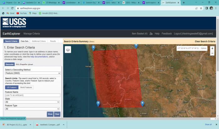
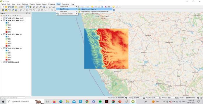
Step2:ImportonQGIS,mergealltilesandaddlayers.
Step3:FinaldigitalelevationmodelofwesternMaharashtra region.
3.2 Steps involved in creating Digital Terrain Model (3D):
Step1:CollectingRawdatafromvarioussources.
International Research Journal of Engineering and Technology (IRJET) e-ISSN: 2395-0056
Volume: 11 Issue: 04 | Apr 2024 www.irjet.net p-ISSN: 2395-0072
Step2:ImportonQGIS,mergealltilesandaddlayers.
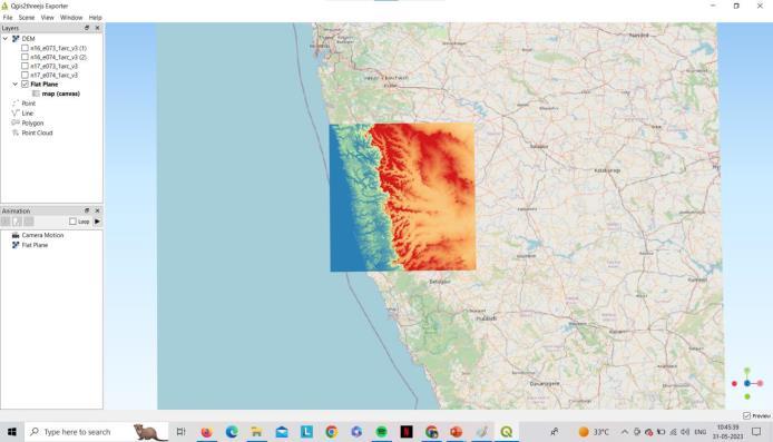
Step3:FinalDigitalElevationModelofWesternMaharashtra Region.
Step 4: Add plug in Qgis2 three is and open it from web option
Step5:DigitalTerrainModelofWesternMaharashtraRegion

Geographical Information System A geographic informationsystem(GIS)isasystemthatcreates,manages, analyzes,andmapsalltypesofdata.GISconnectsdatatoa map, integrating location data (where things are) with all typesofdescriptiveinformation(whatthingsarelikethere). Thisprovidesafoundationformappingandanalysisthatis usedinscienceandalmosteveryindustry.GIShelpsusers understandpatterns,relationships,andgeographiccontext. Thebenefitsincludeimprovedcommunicationandefficiency as well as better management and decision making.Geographical Information System GIS Mapping Building Information Modelling (BIM), is again a very dynamic technology that gives a real-time view of the project development during its complete lifecycle right from its inceptiontoitscompletionandsubsequentlyduringfacility management.Youconceiveaplan,plotitonAutoCAD,export it to over Revit, develop a 3-dimensional facility from the imported AutoCAD plan, assign material with requisite propertiestostructuralandnon-structuralmembers,while, atthesametimekeepingarecordoftheirquantitieswhich automatically done by Revit by feeding it with necessary settings.Thetoolisamazing,nowusingNavisWorksManage, you can perform simulation as per the work schedule preparedonprimaveratocomeacrossanyclashdetection whiletheconstructionisbeingdonevirtuallyonscreen.This encapsulatesinbriefaboutwhatBIMisallabout.Itisquite understandable,fromabovethatbothGISandBIMarenot merelyasoftware,butatechnologythatisbeingenhancedby a multitude of software in combination with each via interoperability. Thus, if both GISand BIM are syncedand utilized for execution of any project, imagine the benefits, humungousbenefitscanbeaccrued.ThiscombinationofGIS andBIMhasbeenreferredtoasGEOBIM.
Solutions and Flood Mitigation Measures After the detailedstudyandanalysisbyvariousexperts,thevarious reasons responsible for this worst flood situation in the region were enumerated. All the natural and man-made issues have been considered. Those have been listed accordingtotheirmostseverityaffectingforthecause.All theseissuesandfindingshavebeendiscussedandformulated intheprevious chaptersindetail.Basedonthis,theFlood Mitigation Measures to be suggested were discussed. The measuressuggestedaresub-listedasshortterm(urgent)and long-term measures for every aspect. These are discussed below. The various aspects considered to suggest the importantmeasuresare
Advanced flood monitoring systems flood forecasting restorationofnaturallanddrainagesystemsencroachments in natural waterways flood absorption measures disaster managementunits advancedfloodmonitoringsystems
International Research Journal of Engineering and Technology (IRJET) e-ISSN: 2395-0056
Volume: 11 Issue: 04 | Apr 2024 www.irjet.net p-ISSN: 2395-0072
Inconclusion,thefloodassessmentinWesternMaharashtra reveals the significant impact and challenges posed by floodingintheregion.Theanalysisoftheavailabledataand informationallowsustodrawseveralkeyconclusions:
1.Frequency and intensity: Western Maharashtra experiencesfrequentandintensefloodingevents,especially duringthemonsoonseason.Thesefloodsareoftentriggered byheavyrainfallandinadequateinfrastructuretomanage theexcesswater.
2.Vulnerable areas: The flood assessment has identified specificregionswithinWesternMaharashtrathataremore vulnerabletoflooding.Theseareasincludelow-lyingregions near rivers, densely populated urban areas, and poorly designeddrainagesystems.
3.Infrastructure shortcomings: The assessment highlights the inadequacy of existing infrastructure to effectively mitigateandmanagefloods.Insufficientdrainagesystems, outdated flood control measures, and encroachment on naturalwaterwaysexacerbatetheimpactofflooding.
4.Environmentalimpact:FloodinginWesternMaharashtra has severe environmental consequences. It leads to soil erosion, contamination of water sources, destruction of naturalhabitats,anddamagetoagriculturallands.Thelongterm effects on biodiversity and ecosystem health are a causeforconcern.
5.Socio-economicimpact:Floodingdisruptsthelivesoflocal communities,causingdisplacement,lossoflivelihoods,and damagetohomesandinfrastructure.Theeconomicimpactis substantial, with damage to agriculture, industries, and infrastructureleadingtoasignificantsetbackintheregion's development.
6. Need for proactive measures: The flood assessment emphasizes the urgent need for proactive measures to mitigate the impact of flooding in Western Maharashtra. These measures should include improved infrastructure planning,constructionofeffectivedrainagesystems,early warning systems, and sustainable land management practices.
7.Collaborationandpreparedness:Giventhecomplexityof flood management, a collaborative approach involving government agencies, local communities, and experts is crucial. It is essential to enhance preparedness through capacitybuilding,communityawarenessprograms,andthe implementationofeffectivedisasterresponseplans.
8. Climate change adaptation: Climate change is likely to exacerbate the frequency and intensity of flooding in the future. Therefore, the flood assessment underscores the importance of integrating climate change adaptation
strategiesintofloodmanagementplans,includingresilient infrastructureandnature-basedsolutions.
TheauthorswouldliketothankDr.P.M.AlandkarHeadofthe Civil Engineering Department RMD Sinhgad School of EngineeringWarjePune,fortheirkindsupportandproviding good infrastructure. The authors are also grateful for her encouragementandsupport.
[1] Dr.K.C.Ramotra,PrashantPatil(2012)ImpactofFlood on Prayag Chikhali Village of Karveer Tehsilin Maharashtra (India): A Comparative Analysis (20052006)JournalofEnvironmentandEarthScienceVol2, No.6
[2] ChandniAhuja,ReshamRajShivwanshi(August-2015) FloodDetectionandManagementFloodDetectionand Management International Journal of Scientific & EngineeringResearch,Volume6,Issue8P.R.Rakhecha, N.R.Deshpande, A.K.Kulkarni, B.N.Mandal, and R.B.Sangam(1995)DesignstormstudiesfortheUpper KrishnaRivercatchmentupstreamoftheAlmattidam site Theoretical and Applied Climatology volume 52, pages219229
[3] Niloy pramanick, Rituparna acharyya, Sandip mukharjee, Sudipta mukharjee, Indrajit pal, Debashis Mitraf,Anirban Mukhopadhyayag (15 February 2022) SARbasedfloodriskanalysis:AcasestudyKeralaflood 2018AdvancesinSpaceResearchVolume69,Issue4, Pages1915-1929.
[4] Jagadish patil, Manisha shinde-pawar, Rajeesh kantha (2020) Flood Disasters 2019 in Maharashtra (India), aftermathandRevivalforNativesandTouristsEco.Env. &Cons.26(2):2020;pp.(693-698).
[5] Chandrakant Narhari Kale (2009) Causes of Floods in Upper Krishna Basin of Maharashtra Nature EnvironmentandPollutionTechnologyanInternational QuarterlyScientificJournalVol.8No.2pp.287-295.
[6] Qomariyatussholihah,Wahyudikuncoro,Sriwahyuni, Sisilia puni suwandi. Elisa Dwi Feditasari (2020) The analysis of the causes of flood disasters and their impacts in the perspective of environmental law IOP Conf. Series: Earth and Environmental Science 437 012056
[7] AdelOmran.,DietrichSchroder.,AhmedElRayes.,and MohammadGeriesh.2011,Floodhazardassessmentin WadiDahab,EgyptbasedonBasinMorphometryusing GISTechniques.GIForumISBN978-87907-509-6.
International Research Journal of Engineering and Technology (IRJET) e-ISSN: 2395-0056
Volume: 11 Issue: 04 | Apr 2024 www.irjet.net p-ISSN: 2395-0072
[8] Aditi Bhadra.,Sutapa Choudhary., and Daita Kar. 2011 Flood hazard Mapping in Dikrong Basin if Arunachal PradeshIndia.WorldAcademyofScience,Engineering andTechnology5:12-22.
[9] Ahmed M Youssef. Biswajeet Pradha., Adballah MohammedHassan.2011.FlashFloodestimationalong St.Katharineroad,SouthernSina,EgyptusingGISbased morphometryandsatelliteimagery.EnvironmentEarth Sciences62:611-623.
[10] BashirAhmad.,MuhammmadShumailKaleem.,Mohsin Jamil Butt., Zakir Hussain Dahri. 2010. Proceedings of AcademicofSciences.47(4):215-226.
[11] Bajabaa S., M Masoud., N.Al-Amri. 2013 Flash Flood hazard mapping based on quantative hydrology. GeomorphologyandGIStechniques(CasestudyofWadi AlLith,SaudiArabia).ArabianJournalofGeosciences DOI10.1007/s12571-013-0941-2.
[12] Eric Kwabena Forjuo., 2011, Flood hazard mapping usingASTERimagedatawithGIS.InternationalJournal ofGeomaticsandGeosciences4(1):932-950.
[13] FowzeJSM.,GunashekaraIPA.,LiyangePP.,Haziraka M. K., Samarakoon L., 2008 Flood Hazard Mapping In LowerReachOfKelaniRiver,SriLanka.Procedingsof 29thAsianConferenceonRemoteSensing3:1731-736.
[14] GommaMDawood.,MerajNMirza.,KhalidAAl-Ghamdi ,2011GISbasedSpatialmappingofFlashFloodHazard in Makkah City, Saudi Arabia. Journal of Geographic InformationSystem.3:217-223
[15] KabirUddin.,DeoRajGurung.,andBasanta Shrestha, 2013,ApplicationofRemoteSensingandGISforFlood hazardManagement:AcasestudyfromSindhProvince, Pakistan.AmericanJournalofGeographicInformation System2(1):1-5.
[16] Michalis Diakakis., 2011, A method for flood mapping based on Basin Morphometry: application in two catchmentsinGreece.NaturalHazards56:803-814.
[17] Muhammad Isma., I O Sanyool,. 2013. Application of Remotes Sensing ( RS) and Geographic Information System(GIS)infloodvulnerabilitymapping:casestudy ofRiverKaduna.InternationalJournalofGeomaticsand Geosciences3:3618-627.
[18] Sina Alaghmand., Rozi bin Abdullah., Ismail Abustan., and Behdokht Vosooggh. 2010. GIS-based river Flood hazardmappinginUrbanAre(AcaseinKayuAraRiver Basin, Malaysia) International Journal of Engineering andTechnology.2(6)488-500.
[19] Pandey,Anupam.,(2009),Mappingof2006floodextent in Birupa Basin, Orissa, India, using visual and digital
Classification techniques on RADARSAT image: A comparative analysis. Indian Institute of Remote Sensing, National Remote Sensing Center (NRSC) and DepartmentofSpace.Dehradun,India.
[20] Sanyal,Joy.,andLU,X.X.,(2004),Applicationofremote sensinginfloodmanagementwithspecialreferenceto monsoonAsia:Areview.NaturalHazards,33,283–301.
[21] V.Sharma, T.Priya,“Developmentstrategies for flood prone areas, case study: Patna, India”, J. Disaster PreventionandManagement,vol.10,no.2pp.101–109, 2001.
[22] W. Kenyon, G. Hill, P. Shannon, “Scoping the role of agriculture in sustainable flood management”, J. Land Use Policy, vol.25, pp. 351-360, 2008 [17] V. N. Mikhailov,V.N.Morozov,N.I.Cheroy,M.V.Mikhailova, “ExtremefloodontheDanubeRiverin2006”,J.Russian MeteorologyandHydrology,vol.33,pp.48-54,2008.
[23] Savenije,H.H.G.,1995.ManandWater,FriendsorFoes. UNESCO/IHEInstituteforWaterEducationPress,Delft, TheNetherlands.
[24] Metternicht, G., Hurni, L. and Gogu, R.,(2005), Remote sensing of landslides: an analysis of the potential Contribution to geospatial systems for hazard assessment in mountainous environment. Remote SensingofEnvironment.98,284–303.
[25] E.A.McBean,M.Fortin,J.Gorrie,“Acriticalanalysisof residentialflooddamageestimationcurves”,CanadianJ. CivilEngineeringvol.13,pp.86-94,1986.
[26] B. Ramlal, S. M. J. Baban, “Developing a GIS based integratedapproachtofloodmanagementinTrinidad, West Indies”, J. Environmental Management, vol. 66, no.1,pp.1-8,2002.
[27] Nawaz. M and Mooyoung, H. 2006 “Hill Torrents Management for increasing Agricultural Activity in Pakistan. Department of Civil and Environmental Engineering,SeoulNationalUniversityKorea
BIOGRAPHIES


Rahul Kapase AssistantProfessor RMDSSOEWarje,Pune.
Mrunmai Panchwadkar StudentCivilEnggineeringDept. RMDSSOEWarje,Pune
International Research Journal of Engineering and Technology (IRJET) e-ISSN: 2395-0056
Volume: 11 Issue: 04 | Apr 2024 www.irjet.net p-ISSN: 2395-0072


Ajay Kawathe
StudentCivilEnggineeringDept.
RMDSSOEWarje,Pune
Suraj Landge
StudentCivilEnggineeringDept.
RMDSSOEWarje,Pune.
Ajinkya Gore
StudentCivilEnggineeringDept.
RMDSSOEWarje,Pune
Aniket Malusare
StudentCivilEnggineeringDept.
RMDSSOEWarje,Pune