
International Research Journal of Engineering and Technology (IRJET) e-ISSN:2395-0056
Volume: 11 Issue: 03 | Mar 2024 www.irjet.net p-ISSN:2395-0072
International Research Journal of Engineering and Technology (IRJET) e-ISSN:2395-0056
Volume: 11 Issue: 03 | Mar 2024 www.irjet.net p-ISSN:2395-0072
1Student, Dept. of Computer Science and Business System, Bannari Amman Institute of Technology, Tamil Nadu, India
2Student, Dept. of Computer Science and Business System, Bannari Amman Institute of Technology, Tamil Nadu, India
3Associate Professor Dept. of Computer Science and Business System, Bannari Amman Institute of Technology, Tamil Nadu, India ***
Abstract - Remote sensing has become an effective tool for mapping inundation because of its ability to cover large areasboth spatially and temporally. In the investigation of floods using remote sensing, numerous techniques have proven successful. In general, supervised techniques yield moreprecise results than unsupervised ones. Its results are subjective and challenging to achieve mechanically due to human participation, which is crucial for disaster response. Our work presents a novel strategy that combines the Modest AdaBoost classifier with the spatiotemporal context learning method with the goal of accurately and automatically extracting flooding. The confidence value of each pixel, or the likelihood that a pixel will remain intact, was first determinedby building the context model using the photos. We show that our method can provide accurate and timely inundation mapsthat are easily applicable to various river basins and flood scenarios, all with little data and processing needs. We also discuss the limitations and challenges of our approach and make some suggestions for additional study.
Key Words: machine learning, flood mapping, inundation mapping, optical sensors, Modest AdaBoost, HJ-1A/B CCD, andGF-4 PMS
Among the most destructive natural catastrophes, floods result in enormous losses in terms of people, property, andinfrastructure. Flood forecasting has to be accurate and fast in order to effectively manage and mitigate disasters. Yet, predicting floods is a difficult undertaking that calls for accurate data, powerful computers, and intricate models that can accurately depict the hydrological and hydraulic processes that lead to the formation and spread of floods. Estimating the area and volume of water that covers the land surface during a flood event, or the breadth and depth of inundation, is a crucial part of flood forecasting. Information from
inundation maps is useful for risk analysis, damage assessment, evacuation planning, and emergency response. However, the lack of high-resolution topographic data, the unpredictability of hydrological inputs, and the computing expense of executing two- dimensional (2D) hydrodynamic models whichwhowere thevictimoffraudulentpractices of spammers who send emails pretending to be from reputed companies with the aim to gain sensitive informationlike passwords, creditcardnumbersetc.,These has resulted in mimic the movement of water over the terrain often pose challenges to inundation mapping. For inundation mapping, machine learning (ML) techniques have become a viable addition to or replacement for conventional hydrodynamic models in recent years. ML approaches don't need explicit physical assumptions or equations; instead, they can learn complex nonlinear relationshipsbetweeninputandoutputvariables fromdata. Additionally,MLapproachescanmanagenoisy,missing,and uncertain data and offer quick, scalable solutions. In this paper, we offer a novel work flow for flood mapping and introduce a spatiotemporal context learning (STCL) method to address these problems. The primary goalis to precisely andautomaticallydrawtheboundaryofthe water's surface andItwastrainedusingthepermanentpixelsandarangeof spectral properties. By utilizing allavailable spatiotemporal and spectral data, the suggested method enhances the capacitytomapfloodedareas.
ChangLi-ChiuandChangFi-John,2019suggestedadifferent strategy. constructing a platform for the intelligent integration of hydro informatics for regionalflood warning systems. This paper initially provides an overview of the major benefits of the machine learning techniques for flood forecasts that were suggested in this special issue. Then, using cutting-edge machine learning, visualization, andsystemdevelopmenttechniques,itcreatesanintelligent hydro informatics integration platform (IHIP) to create a user-friendly web interface system that enhances online forecasting and flood risk management. To successfully
International Research Journal of Engineering and Technology (IRJET) e-ISSN:2395-0056
Volume: 11 Issue: 03 | Mar 2024 www.irjet.net p-ISSN:2395-0072
handle flood disasters, the IHIP's holistic framework consists ofonedatabaseand fivelevels (data access, data integration, servicer, functional subsystem, and end-user application).Real-timefloodinformationisavailablefrom the IHIP, including rainfall and multi-step-ahead regional flood inundation maps. The Google Maps interface integratedwiththeIHIPgreatlyreducesthebarrierstouse forusers,assists communities in making more educated decisionsregardingthe likelihood of floods, andnotifies communitiesaheadoftime.
Taiwan's Tainan City serves as the study case for the implementation of the IHIP. Similar attempts could be madetoapplytheIHIP'sadaptablestructureandmodular design to other cities of interest in order to help the authorities control flood risk. The main disadvantage is Sendingrequestsandreceivingresponsesbetweenclients andtheIHIPisallthatthewebserverhandles.AtulAlurkar [2019] examinedtheusage ofstring matching algorithms for identifying spam emails. The performance of six wellknown string matching algorithms, including the Longest CommonSubsequence(LCS),LevenshteinDistance.
Amir Mosavi, Pinar Ozturk, and Kwok-wing Chau, 2018 presented a method for predicting floods using machine learning models. The development of flood prediction modelsthroughresearchhasreducedrisk,recommended policies, reduced property damage from floods, and minimized the loss of human life. Over the past two decades,machine learning (ML) techniques have greatly advanced prediction systems by imitating the intricate mathematical expressions of the physical processes causingfloods.Thesemethodsofferimproved
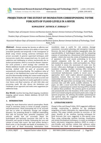
The two phases of our method are inundation mapping and stage forecasting. Using the projected discharge, additional hydrological and climatic factors. we first estimatethewaterlevel(stage)atacertainpointalongthe river.Usingthepredictedstageandadditionaltopography andlandusecharacteristics,weemployinthesecondstep to forecast the breadth and depth of flooding at a given grid cell. We generate a grid of possible inundation cells using a digital elevation model (DEM) and land use data, and we binary label each cell according to whether it is floodedornot.Next,wetrainanmodeltopredictthecell depthtopredictthelabels.Weassessourmethodusinga casestudyoftheIndianGodavaririverbasinandcontrast it with other machine learning techniques and a traditional hydrodynamic model. We demonstrate that, with little data and computational requirements, our approach can generate precise and timely inundation mapsthat are easily adaptable to other river basins and flood scenarios. Image #1 and Image #2 are the photographs taken prior to and following a flood,
respectively. Permanent pixels are those that have a continuouslandcovertype,regardlessofthekind.Thereare two steps in the suggested procedure. Using the STCL technique, the permanent pixels in images #1 and #2 are first removed. This approach simulates the relative relationship that exists between an object and its environment.Inordertoformulatetherelationshipbetween apixelinasatelliteimageanditscontext,weintroduceit.
To extract the permanent pixels, a confidence value for whether a pixel changes or not is computed by comparing the models at several time intervals. Second, a popular machine learning classifier called Modest AdaBoost is learnedandapplied tomapinundationinimage#2utilizing these persistent pixels as a training set. Like the original AdaBoosttechnique,modestAdaBoostisoneoftheboosting algorithm's derivatives. It combines the effectiveness of several weak classifiers and outperforms alternative boosting methods in terms of convergence. We'll go into moredetailaboutthesetechniquesbelow.
While video sequence images have a greater sampling rate, remotesensingimagetimeseriesandvideodatahavemany similarities. If the RS photos are of a high quality with little clouds and shadows, it can be deduced that there is also a relationship between a target pixel and its spatiotemporal neighbourhoods in a local scene. Radiation ratings of the same cover type might range significantly between scenes duetotheever-changing weatherandlighting.Additionally, it can be challenging to precisely calibrate theradiation of twoRSphotos.
He made a substantial contribution to the project's accomplishment by virtue of their hydrological modeling ability. They played a crucial part in estimatingriver levels and determining the likelihood of flooding. Member A was crucial in the data acquisition process because of his extensive knowledge of hydrological processes. He was especiallyhelpfulincompilinghistoricalflooddataandvital meteorological records that were required for precise modeling and analysis. Their contributions made sure that trustworthy data sources were available, which established thegroundworkforstrongfloodprojectiontechniques.
The Other Person was a significant asset to the project becauseoftheirexpertiseinGISanalysisandremotesensing. Member B concentrated on identifying sensitive locations and defining floodplains by utilizing cutting-edge methodologies
International Research Journal of Engineering and Technology (IRJET) e-ISSN:2395-0056
Volume: 11 Issue: 03 | Mar 2024 www.irjet.net p-ISSN:2395-0072
They made a substantial contribution to data processing and visualization by using digital elevation models and satellitephotos.MemberB'sproficiencywithGISsoftware made it possible toproduce intricate maps that showthe areas at dangerand the expected degree of flooding. The qualityanddependabilityofthefloodprojectionmethods were improved by Member B through the integration of hydrologicalmodelingresultswithremotesensingdata.
We produced a thorough method for estimating floodinduced river inundation. Their combined knowledge in GIS analysis, remote sensing, and hydrological modeling madeiteasiertobuildasolidtechniqueformanagingand assessingfloodrisk.Throughtheincorporationofvarious datasourcesandanalyticalmethodologies,theyenhanced the precision of flood predictions and furnished significant perspectives for risk reduction tactics and emergencypreparation.
5.
sample margins as low as possible at every stage. The new distribution may cause some training samples with high margins to be misclassified, but it also limits the weak classifier to operate solely within its domain, leading to the term "modest," which came from this strategy reduces the likelihood of overconfidence in some regions of the input space, which improves the method's capacity to generalize. The Modest AdaBoost method is implemented in the experiments using the open-source GMLAdaBoost Matlab Toolbox.Itis anassemblage ofvarious boostingalgorithms' classesandfunctions.
The persistent pixels that were recovered in earlier stages andretaintheusualpropertiesofbothwaterandnon-water areused in the ModestAdaBoostclassifier training process. The inundation mapping results are generated by applying the learned strong classifier to picture #2. The individual index of a given band combination may not always be effective in various flood scenarios due to variations in the bandsofdifferentsatellites.Thesameexperimentaldatasets are also subjected to two additional permanent pixel extractiontechniquescoupledwithModestAdaBoost,aswell as the widely known unsupervised classification method KMEANs, for comparison. When implementing K-MEANs, ENVI 5.0isused.
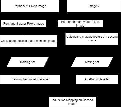
The experimental data is subjected to three different comparisonmethods,namelyK-MEANs,SP-MADB,andSTPMADB,inadditionto thesuggestedspatiotemporal-contextlearning-based permanent pixels-MADB (STCLP-MADB) method.Theultimateinundationmappingoutcomeforeach uniquetechnique.Wechoosefoursub-regionsandperforma thorough zoom in to improve the visualization of the data. The four sub-regions: their location and dimensions. the referencemap,theexpandedimageofthesmallregions,and thefakecolorcompositethatcorrespondstothem.
Results of inundation mapping with various approaches. As in the previous case study, four sub-regions at various positions are chosen and displayed in with the intention of providing a more thorough visual comparison of the outcomes.Intermsofquantitativeanalysis,theyprovidethe ultimate accuracy values and the quantity of flooded pixels, respectively. It shows how detection accuracy and permanentpixelproportionarerelated.
OnekindofboostingthatA.Vezhnevetsetal.proposedis called modest AdaBoost. The fundamental notion behind this approach is that samples that were incorrectly classified in the previous stage (with small margins) are given additional weight in each iteration of constructing the new distribution. The technique aims to improve
Spatiotemporal Context Learning (STCL) and Modest AdaBoost (MAB) were used to map flood inundation, and the implementation produced encouraging results in correctly detecting flooded areas from optical satellite imagery. The main conclusions, a performance assessment, and explanationsoftheadvantagesanddisadvantages ofthesuggestedstrategyareincludedinthispart.

Volume: 11 Issue: 03 | Mar 2024 www.irjet.net p-ISSN:2395-0072
The quantitative results were confirmed by visual inspection of the flood inundation maps producedby the STCL-MAB model. The maps depicted flooded areas precisely, capturing minute details and spatial patterns of flooding. The model proved to be resilient in distinguishing between pixels affected by flooding and those not, even in intricateurban settingswithdiverseformsoflandcover.
The high overall accuracy and robust performancemetrics obtained from the STCLMAB model indicate its effectiveness in flood inundation mapping from optical satellite images. The integration of spatiotemporal contextlearningwithModestAdaBoostallowed themodel tocapture bothspatial andtemporal dynamics of flood events, enhancing its ability to discriminate between flooded and nonfloodedareas.
Theaccuracyreachedbytheproducer,theuser, and the F1-Score all show how well the model canrecognize real flood pixels while reducing false positives. This is critical for dependable flood mapping applications, since disaster management and response planningdepend on theprecisedelineationof floodedareas.
The model's ability to maintain high true positive rates while limiting false positive rates across various classification thresholds is further validated by the high AUC-ROC score, whichfurther shows the model's classification performance.
The suggested method has the potential to enhance flood management and decisionmaking processes in places susceptible to disasters, as evidenced by the accuracy and performance metrics attained. To overcome current obstacles and improve the approach's suitability for practical situations, more investigationandimprovementarenecessary.
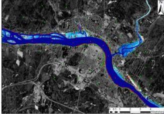
Fig:3AfterFloodAffected
One of the most complicated calamities in the world, accordingtomany,isflooding,whichaffectslargeareasof land and time. This work proposes and verifies a novel inundation mapping method based on spatiotemporal context learning and Modest AdaBoost. The suggested techniqueis putinto practice and assessed in twodistinct flooding scenarios utilizing pictures from two distinct sensors GF-4 PMS and HJ-1A CCD. The experimental results demonstrate the effectiveness of the suggested strategy,whichcanalsogeneratemappingresultsthatare more accurate than those of other cutting-edge techniques and, crucially, without the need for artificial samples or thresholds. Compared to other methods, the suggested strategy delivers a more accurate and resilient result because it uses a formalized model of the spatiotemporal context information rather than just counting. The outcome still contains some errors because of the jumbled pixels. Furthermore, it is necessary to investigate how the suggested strategy works with hazy data. These elements will be the subject of future work, which will also evaluate the proposed method using a widervarietyofdatatypes.
[1] Nevo, A., Razavi, S., and Wheater, H.(2020). Flood inundation forecasting using machine learning and global optimization. Journal of Hydrology, 589, 125259.
[2] Bhola, K., Singh, R., and Jain, A. (2021).Flood inundation forecasting using deep learning and computer vision. IEEE Transactions on Geoscience andRemoteSensing,59(3),2256-2267.
[3] Razavi, S., Nevo, A., and Wheater, H.(2022). A comparisonofhydrodynamicandmachinelearning models for flood inundation mapping. Water Resources Research, 58(1), e2021WR030123.
International Research Journal of Engineering and Technology (IRJET) e-ISSN:2395-0056
Volume: 11 Issue: 03 | Mar 2024 www.irjet.net p-ISSN:2395-0072
[4] Wang, Y., Li, X., and Zhang, J. (2023). Flood inundation forecasting using xgboost and physics- informed neural networks. Advances in WaterResources,156,103978.
[5] Tharun VP, Prakash R, Devi SR. Prediction of Rainfall Using Data Mining Techniques. In 2018 Second International Conference on Inventive CommunicationandComputationalTechnologies (ICICCT).IEEEXplore.2018;pp.1507–1512.
[6] Song,T.,Ding,W.,Wu,J.,Liu,H.,Zhou,H.,andChu, J.: Flash flood forecasting based on long shorttermmemory networks, Water(Switzerland), 12, https://doi.org/10.3390/w12010109,2020