
International Research Journal of Engineering and Technology (IRJET) e-ISSN:2395-0056
Volume: 11 Issue: 02 | Feb 2024 www.irjet.net p-ISSN:2395-0072
International Research Journal of Engineering and Technology (IRJET) e-ISSN:2395-0056
Volume: 11 Issue: 02 | Feb 2024 www.irjet.net p-ISSN:2395-0072
Adamu Assefa a Gedion Tsegay a Hu Xialin a*
a UNEP-TONGJI Institute of Environment for Sustainable Development (IESD), College of Environmental Science and
Abstract Engineering, Tongji University, 1239 Siping Road, Shanghai 200092, China
Environmentalsustainabilityreliesonacomprehensiveanalysisthatintegratesbothlanduseandcoverchangeswithlocally
adopted indigenous knowledge of land management practices. The study reveals a noteworthy increase in traditional agroforestry land, expanding spanning three decades (1993-2023). Utilizing Landsat Thematic Mapper (TM) images from 1993 and spot images from 2023, processed via ERDS IMAGINE V9.3, our investigation provides insights into the evolving regional landscape. The study reveals significant changes: Traditional agroforestry land increased from 10,808 to 18,145 hectares(46.28%to77.71%oftotalland),indicatinganotableshiftinagriculturalpractices.Incontrast,croplanddecreased from 9,845 to 4,244 hectares (42.16% to 18.18% of the total area), signaling a substantial move away from traditional crop plantingtoagroforestry.Settlementareasgrew by106 hectaresdueto rapidpopulationgrowth, whileshrubandbarelands notably declined. These changes highlight a transition in land management practices towards agroforestry. Implications include positive impacts on biodiversity, ecosystem services, and soil health with agroforestry expansion. The reduction in cropland suggests a shift to more sustainable and diversified agricultural practices, potentially enhancing resilience to environmental changes. Settlement area growth underscores the need for sustainable urban planning to address increasing
Keywords: Land Use Change, Traditional agroforestry Practices, Satellite Imagery Analysis, Indigenous Knowledge,
EnvironmentalSustainability
Landuse/landcoverchangeissignificantlymodifiedoverthepastthreedecadesinthestudyarea.
GeospatialtechnologyisakeytoolforLanduse/landcoverchangeanalysis.
Agroforestrycoverhassubstantiallyincreasedduetofarmers'indigenouslandmanagementinthestudyarea.
Land use and land cover change (LU/LCC) analysis stands as a critical global concern, its impact resonating across generations by profoundly influencing both natural ecosystems and human societies (Chughtai, Abbasi et al. 2021, Nziguheba,Adewopoetal.2021,Feng,Wangetal.2023).Thisanalyticalframeworkservesasafundamentalindicatorof environmental shifts, exerting significant effects on vital ecosystem processes, biological cycles, and overall biodiversity
ThedynamicsofLU/LCC,largelyinstigatedbyhumanactivities,havebroughtaboutsubstantialalterationsinregional and local landscapes. These changes are primarily driven by the rapid growth and expansion of urbanization, burgeoning populations, technological advancements, and the persistent challenge of land scarcity(Geist, McConnell et al. 2006) The resultingtransformationscarryprofoundimplications,influencinghydrologicalcycles,microclimates,groundwaterresources, thegradualprocessoflanddegradation,andthemethodologiesemployedinlandmanagementpractices (Lambin and Geist
Article Highlights land demands, while the decline in shrub and bare lands raises concerns about habitat loss and potential impacts on local wildlife. (Chang,Houetal.2018). 2003).
Inthesub-SaharanAfricanregion,characterizedbyrapidpopulationgrowthcoupledwithextensivenaturalresource exploitation, LU/LCC is notably affecting forest cover due to the expanding footprint of cultivable lands (Bassett and Zuéli
International Research Journal of Engineering and Technology (IRJET) e-ISSN:2395-0056
Volume: 11 Issue: 02 | Feb 2024 www.irjet.net
p-ISSN:2395-0072
2000) Agroforestry, as part of a multifunctional working landscape, can play a major role in conserving and enhancing biodiversityfromfarmstothelandscapelevelinbothtropicalandtemperateregionsoftheworld(Jose2012)
Reflecting this trend, Ethiopia has witnessed a decline in forest cover, primarily attributed to agricultural encroachments and settlements (Tesfahunegn 2013, Kindu, Schneider et al. 2016) Concurrently, smallholder farmers across Ethiopia employ diverse agroforestry practices, varying according to socio-economic and biophysical contexts (Jamala 2013, Iiyama,Takahashietal.2017,Abrham,Beshiretal.2020) Recentgovernmentalinitiativeshavereportedanincreaseinforest cover, attributed to national afforestation programs (Kassa, Abiyu et al. 2022). A meticulous understanding of LU/LCC alterations holdspivotalimportance,guiding effectivelanduseplanningand management,particularlyindiscerningchanges inforestcover(Shimizu,Otaetal.2019).
Furthermore, the preservation and adaptation of traditional knowledge and practices, coupled with a decentralized autonomousgovernancesystem,showcasethatlocalcommunitiescannotonlybepartofecosystemswithuniquebiodiversity but can also be the main actors in actively conserving biodiversity(Marentes, Venturi et al. 2022). Agroforestry systems, rooted in traditional forest-related knowledge, emerge as an effective alternative to conserving biodiversity and ecosystem services. This approach contrasts with strict nature protection where humans are perceived as a negative factor (Marentes, Venturietal.2022).Agroforestrysystemssupportagreatervarietyofplantspecies,includingnativeplants,and providemore complexhabitatand landscapeheterogeneity, resulting inhigherbiodiversitycomparedtoconventionalagriculturalsystems (Haggar,Ponsetal.2019).
Recent studies suggest that a wider implementation of agroforestry principles and practices can play a vital role in achievingmoresustainablemethodsofproducingfood andfiberglobally.Thisapproachnotonlyprovideseconomicbenefits to farmers but also yields environmental benefits for society(Pantera, Mosquera-Losada et al. 2021) Studies in Europe have revealedthattraditionalagroforestry enhances erosioncontrol, biodiversity,andsoilfertility.Agroforestrycanincreaseland productivityasthecombinationoftreeandcropsystemsleadstoamoreefficientcaptureofresourcesthanseparatedtreeor cropsystems(Torralba,Fagerholmetal.2016).Theconservationofplantdiversityintraditionalagroforestrycancompensate fordeforestationinlessprotectedareas(Meragiaw,Wolduetal.2022).
Theprimarysourceoflivelihoodfor farmersinthestudyareaisagriculture,characterized bytraditionalproduction techniques. The dominant indigenous knowledge of agroforestry and agriculture practices has been passed down from generation to generation, with new inventions building upon what has been inherited over the years (Ware, Matewos et al. 2023). Farmers have adopted environmentally friendly traditions, high-value agricultural practices, land management, and agroforestryagriculturalactivities. Most smallholderfarmsaredominated by multipurposespecies thathave nutritionaland economic importance, such as avocado trees, Wesse (false banana), and cabbage. Coffee and other fruits are grown as cash crops for income generation, while Wesse serves as a staple food a highly indigenous and drought-resistant crop contributingtolong-termfoodsecurityineveryhousehold(Wana,Kudamaetal.2022)
A research gap exists in thecurrent literatureas previous studies in the field have addressed a range of issues, yet there is a notable dearth of comprehensive exploration into the role of indigenous knowledge in traditional agroforestry within the context of sustainable land use and land cover (LULC) management systems. This gap highlights the need for further investigation to better understand and integrate indigenous knowledge into the discourse surrounding sustainable land management practices, particularly in the realm of traditional agroforestry This research aims to comprehensively analyzethelanduseandlandcover(LULC)changesintheAletaWondoWoredaofSidama,SouthernEthiopia,overtheperiod from 1993 to 2023. The primary objectives include assessing the rate and nature of LULC change during this three-decade span, utilizing advanced techniques such as the LULC Change Detection Matrix. The study seeks to provide insights into the dynamic shifts in the regional landscape, with a specific focus on the implications of these changes on the environmental sustainability of the study area. By investigating the patterns and consequences of LULC changes, the research aims to contributevaluableinformationforinformeddecision-makinginlandmanagementandsustainabledevelopmentstrategies.
International Research Journal of Engineering and Technology (IRJET) e-ISSN:2395-0056
Volume: 11 Issue: 02 | Feb 2024 www.irjet.net p-ISSN:2395-0072
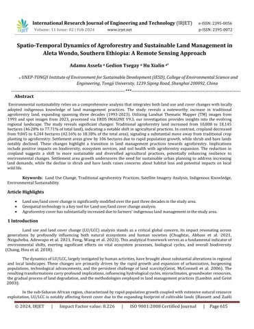
2.1. Description of the study area
Aleta Wondo (Woreda) district is one of 30 rural administration structures in the Sidama region, which is situated in a central geographic position a little inclining towards southern Ethiopia. With respect to its absolute position, it is situated between 6◦31’ - 6◦41′N latitude and 38°21’- 38°32’E longitude( Fig.1). The woreda has 30 kebeles (the smallest administration in Ethiopia), among this about 19 kebeles produce coffee. Based on the Woreda Administration report,2022,the totalpopulationis 137,855,outof whichmale68,238and female69,617, 101,593arerural and6262areurbanpopulationandalsothehouseholdnumberis21,569(Sidamareport2020).
The total land area of the Woreda is 23, 350ha. Among these 64% is covered with forest and permanent crops,25%withannualcrops,8%iscoveredbynatural, cooperative,andprivateforests,2%iscoveredbygrazing landandtheremaining1%ofthelandiscoveredbyothers.Furthermore,thedistrictisknownforproducingagroforestrypracticeswhichmakeitgreener.
As far as agro-climatic condition is concerned, 37% of the landmass of the district constitutes highland/dega agro-climatic condition while the remaining 63% is categorized under midland/woyina dega agroclimatic zone. The annual temperature of the district varies between 15.1°C to 22.5° while the annual rainfall ranges between 1200mm and 1600mm. TheFarming system of the study area generally depends on rainfall agriculture and mixed farming system which involves both crop production and animal husbandry. The major growing in addition to coffee, seasonal crops such as maize, haricot bean, wheat and sweet potato, wesse, and maize are the main staple crops. Farmersgrow wesse formultipurposeusessuchasforfood,andanimalfeed,toconstructtraditionalhouses(Borrell,Biswaset al.2019,Ware,Matewosetal.2023).
2.2 Data sources
2.2.1 Remote sensing data acquisition and processing
Landsatimagesfrom1993, 2003,2013and2023 wereutilizedtoanalyzethespatiotemporalLULCchangeinthe AletaWondoDistrict. ERDASImagine2014softwareis usedto processtheLandsat images.ThestudyareaLULCtypeswere classifed over four years (1993, 2003, 2013 and 2023) using a supervised classifcation method with a maximum likelihood algorithm(Churches, Wampler et al. 2014, Wu, Du et al. 2017) to accomplish spatiotemporal LULC changes. For LULC classifcation, Landsat 5TM 1993, Landsat , 2003 Landsat7ETM, 2013 Landsat 8 OLI and TIRS and 2023 Landsat 9 OLI and wereutilized(Table1;Fig.2).WeusetheLandsatimagesinthedayofclearsky to avoidtheimpactofcloudcoveronimage quality.Moreover,weperformimagepre-processingtechniques.
The year 1993 is considered the starting point for LULC analysis due to its historical moment in the Ethiopian government structure. Change of government, declaration and implimentation of massive poverity aIlivation program. The year 2003 was chosen because of the government policy revesion and implimentation of agricultural led industrialization. 2013waschoosen to notice changes intenyears intervals.Finally,theyear2023waschosentoassesschangesandcurrent statusoflanduselandcoverwith respect farmersindiginousagroforetrypractice.
International Research Journal of Engineering and Technology (IRJET) e-ISSN:2395-0056
Volume: 11 Issue: 02 | Feb 2024 www.irjet.net p-ISSN:2395-0072
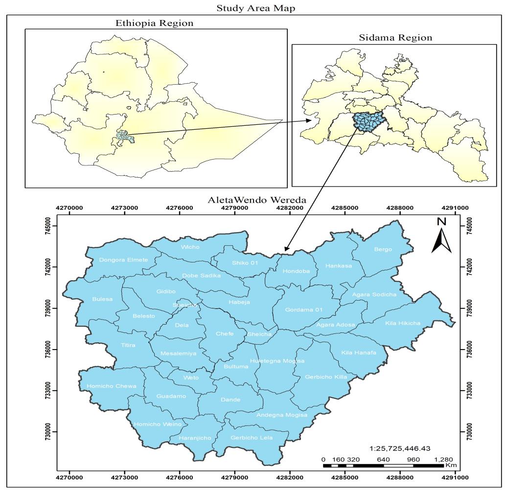
Fig1: Thelocationandmap of studyarea(AletaWondoDistrict)
Table.1.DataDescriptionandsourceusedinthisstudy
GISDatalayer
DataDescription Datasource
Vector(polygon) District(Woreda)Boundary CSA,2021
SatelliteImage 1993Landsat5TM USGS
2003Landsat7ETM
2013Landsat8OLIandTIRS
2023Landsat9OLIandTIRS
Groundtruth Groundtruth2023 Fieldsurvey
2.2.2
In our research, we conducted a comprehensive Land Use and Land Cover (LULC) analysis of the study area, categorizingitintofivemajorclassesbasedontheirdominance,asdepictedin Table2.Thesecategoriesencompassessential componentsofthelandscape:AgroforestLand,areasprimarilydedicatedtoagroforestrypracticesintegratingtreesorwoody
© 2024, IRJET | Impact Factor value: 8.226 | ISO 9001:2008 Certified Journal | Page618
International Research Journal of Engineering and Technology (IRJET) e-ISSN:2395-0056
Volume: 11 Issue: 02 | Feb 2024 www.irjet.net p-ISSN:2395-0072
perennials with agricultural crops or livestock; Settlement, zones predominantly occupied by residential infrastructure and associated facilities; Bareland, regions devoid of substantial vegetative cover often exhibiting exposed soil or limited vegetation; Bushland, areas characterized by dense, low-lying vegetation predominantly consisting of shrubs or bushes; and Cropland, designated areas focused on agricultural cultivation, specifically catering to crops or arable farming. Each classification represents a distinct facet of land use or land cover within the study area, delineating the diverse components shaping the landscape's composition. This comprehensive classification scheme serves as a foundational tool for understandingthespatialdistributionanddynamicsofvariouslanduses,crucialforourresearchanalysis.
The overall accuracy index (Congalton 1991) is calculated by dividing all properly identified pixels by the total number of pixels in the matrix (Eq.1). The kappa coefficient measure the degree of agreement between two maps when all elementsoftheerrormatrixaretakenintoaccount(Eq.2).
where: Obs is it represents accuracy reported in error matrix (overall accuracy) and Exp is it represents correct classifcation.
Fig.2MethodologicalflowchartforthedeterminationofLULCchange
International Research Journal of Engineering and Technology (IRJET) e-ISSN:2395-0056
Volume: 11 Issue: 02 | Feb 2024 www.irjet.net
Table.2DescriptionsofLULCclassesusedinthestudyarea
Lu/LcClasses Discripition
p-ISSN:2395-0072
Settlements Areas allotted for permanent residential, commercial areas, institution and infrastructures
ShrubLand Areas aplant communitycharacterizedvegetationdominatedbyshrubs, includinggrasses,herbs
BareLand landisareaswithnovegetationcoveronandwhenweclassyasbareland
AgroForestLand landcoveredbyforestandcropsbothperennialandseasonalcrops.
CropLand categorythatincludesareasusedfortheproductionofadaptedcropsforharvest.
Theamountofchangedareaandextentofchangeshouldbeexaminedtoidentifythemagnitudesof changeinterms of LULC change (Taddese 2020). Furthermore, the percent of change and rate of change were computed (Eq.3) to show the magnitudeofthechangesbetweentwoperiods(Gessesse,Alemieetal.2016,Abebe,Derebewetal.2019,Negassa,Mallieetal. 2020).
RateofChange = = (3)
whereA2 isanareaofLULC(Hectar)intime2,A1 isanareaofLULC(Hectar)intime1;ZisTimeIntervalbetweenA2 andA1 in years. Thetechniqueofpost-classifcationwasused to detectLULC change(Yang, Zheng etal.2012).TheLULCchangematrix wascreatedtoshowtheoverallLULCchangebetween1993and2023.
ThematicMapperimageryfrom1993,EnhancedThematicMapperPlus,andOperationalLandImagerdatafrom2023 were employed to scrutinize the spatiotemporal changes in Land Use and Land Cover (LULC). The study area's LULC was categorized into agroforest land, bushland, bare land, settlement, and cropland. Across the study period, there was a significantexpansioninagroforestland,asevidencedintheprovidedtable.Thisgrowthcoincidedwithanotablereduction in cropland,attributedtotheadoptionofagroforestryagriculturalpracticesbylocalfarmers.
From1993to2023,therewasacleartrend:agroforestandsettlementlandsincreasedwhilecropland,shrubland,and bare land diminished. Conversion dynamics, such as the transformation of cropland, shrubland, and bare land into agroforestrylandandsettlementswithintheAletaWondoDistrict,wereobserved(Manderso2019).
This transformation was propelled by a combination of traditional agroforestry practices and the population surge linked to the widespread adoption of agroforestry agricultural practices(Pantera, Mosquera-Losada et al. 2021, Meragiaw, Woldu et al.2022, ShuklaandDhyani 2023) Studieshavereported asignificant increaseinagroforest land within theAleta WondoWoreda,attributingittohumanactivitiesthatcontributedtothearea'sforestcoverenhancement.Traditionalfarming management practices played a vitalroleinmaintainingand improving soilfertility andcropproductivity. Thecultivationof treesandthedevelopment of effectivemixturesofvariouscomponents, evolved overtimewithout externalinput,havebeen notedinthearea.However,theunderstandingoftheimpactofindigenousfarmtreesonsoilfertilityremainslargelyconfined tolocalfarmers'knowledge(ZebeneandÅgren2007)(Fig.3).
Backin1993, theagroforestryland withinAleta Wondo Woreda encompassed10,808.00hectares (46.28%), whilecropland, shrubland, bare land, and settlement occupied 9,845.00 hectares (42.16%), 2,215.00 hectares (9.49%), 377.00 hectares (1.61%), and 106.00 hectares (0.45%), respectively. Over time, therehas beena substantial increasein both agroforest land and settlement. The agroforestry land expanded by 79.3%, covering an additional 7,337 hectares, while settlement land increasedby410%,totalinganextra435hectares.
International Research Journal of Engineering and Technology (IRJET) e-ISSN:2395-0056
Volume: 11 Issue: 02 | Feb 2024 www.irjet.net p-ISSN:2395-0072
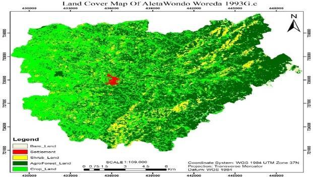
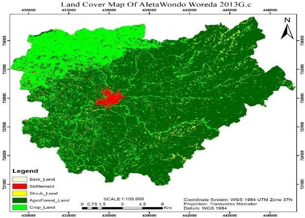
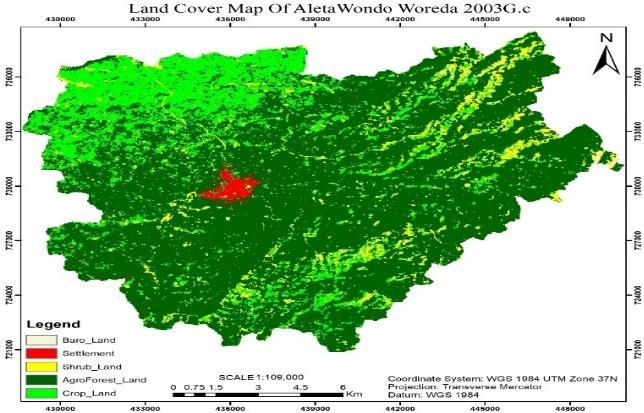
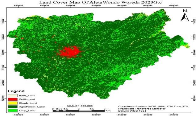
Fig.3LULCmapofAletaWondoWoredawherethechangesshowsin 1993,2003,2013and 2023
Table3.Landuselandcoverchange1993to 2023
CoverChange
Thesechanges parallel thefindings o(Deribew and Wana 2019) , highlighting theimpact of population pressureand local agricultural practices on land use patterns By 2023, the landscape had undergone significant alterations. Cropland, shrubland, and bare land had decreased substantially by 5,601 hectares (132%), 1,835 hectares (483%), and 337 hectares (842%), respectively. Conversely, agroforestry land expanded by 18,145 hectares (77.71%), while settlement land increased by541hectares(2.32%).Ouranalysisunderscoresacleartrend:theremarkableincreaseinagroforestrylandhascomeatthe expenseofcropland,shrubland,andotherLULCcategoriesoverthepastthreedecadeswithinthestudyarea,asdelineatedin theLULCchangeassessment(refertoTable3).
International Research Journal of Engineering and Technology (IRJET) e-ISSN:2395-0056
Volume: 11 Issue: 02 | Feb 2024 www.irjet.net p-ISSN:2395-0072
1993 2003 2013 2023


Fig.4.ChangeinLanduselandcoverinAletaWondoWoreda1993to2023
Thereliabilityofthedatais97.3% withkappavaluesof0.80,0.99, 0.99,and1,thetotalclassificationaccuraciesforthestudy periods of 1993, 2003, 2013, and 2023 were 82.2%, 99.7%, 83.1%and 87.6%, respectively. A kappa score of larger than (>) 0.80 (80%) indicates a significant agreement, while a value of between 0.60 (60%) and 0.80 (80%) indicates a substantial agreement(LandisandKoch1977)
Between 1993 and 2023, while cropland, shrubland, and bareland experienced declines at rates of 186.7 hectares/year,61.2hectares/year,and11.2hectares/year,respectively,theeconomyofthestudyarea,reliantonagriculture, witnessed a surge in agroforestry agricultural land and settlement construction. This surge was necessitated by rapid population growth, driving the decline in shrubland, bare land, and even conventional farm cropland, positively influencing agroforest ecosystems. Over three decades, agroforestry agricultural land expanded at a rate of 244.6 hectares/year, while settlementsgrewby14.5hectares/year(refertoFig.4).
Our findings indicate a consistent increase in agroforest cover within Aleta Wondo Woreda, aligning with prior research(Gómez,Buenoetal.2022),(Pellikka,Heikinheimoetal.2018,Geeraert,Hulsmansetal.2019) Concurrently,similar declining trends were observed in cropland, shrubland, and bareland. Notably, nearly 132% of croplands transitioned to agroforestrylandinthepast30years,owingtofarmers'adherencetotraditionalagroforestrypractices.Homegardeninghas remainedintegraltothelocalsubsistenceeconomyforcenturies,crucialforfoodsecurity(Quandt,Neufeldtetal.2023).These gardens,mirroringnativevegetationinthetropics,aidinconservinglocalbiodiversityandmeetingtheincreasingdemands of the community (Tk 2014) Despite significant increases in agroforestry and substantial declines in cropland over 30 years, settlement land expanded by over 410%, rising from 106 hectares in 1993 to 541 hectares in 2023 due to housing and infrastructure development driven by rapid population growth. Conversely, cropland, shrubland, and bareland witnessed dramaticdeclinesof5601hectares(132%),1835hectares(483%),and377hectares(843%),respectively,duringthisperiod (refer to Fig. 5) This shift indicates a trade-off between agroforestry and these other land uses, specifically highlighting farmers'shiftfrommonoculturecropcultivationtotraditionalagroforestrypractices.Thisobservedchangeindicatesadecline of shrubland and cropland direct result of farmers’ land use change from monoculture crop cultivation to traditional agroforestryagriculturalpractices.
Our result is consistent with a previous study by(Woldesenbet, Wudmatas et al. 2020), emphasizing the positive impactofEnset-basedagroforestrypracticesinreducingsoilerosionrisksinwatersheds,necessitatingimmediateintegrated landusemanagementinterventions
International Research Journal of Engineering and Technology (IRJET) e-ISSN:2395-0056
Volume: 11 Issue: 02 | Feb 2024 www.irjet.net p-ISSN:2395-0072
However,alongsidecropland,shrubland,andbareland,therehavebeensignificantdeclinesof1835hectares(483%)and377 hectares (843%), respectively, over the study period, signaling the substantial impact of rapid population growth on diminishingagriculturallanduseintensity(Jiang,Dengetal.2013).Farmers,strivingtocultivateallavailablelands,including previously peripheral bare lands, contribute to this decline. Furthermore, with a household population of approximately 21,569andatotallandareaof23,350hectares,thelandholdingpercapitastandsatnearly1hectare/person.Thistightratio illustrateshowrapidpopulationgrowthnegativelyaffectslanduseandlandcovermanagementinthearea(refertoFig.5).
Magnitude of dynamics in LULC
Change 2023 1993
Magnitudesofdynamicsoflanduseandlandcover
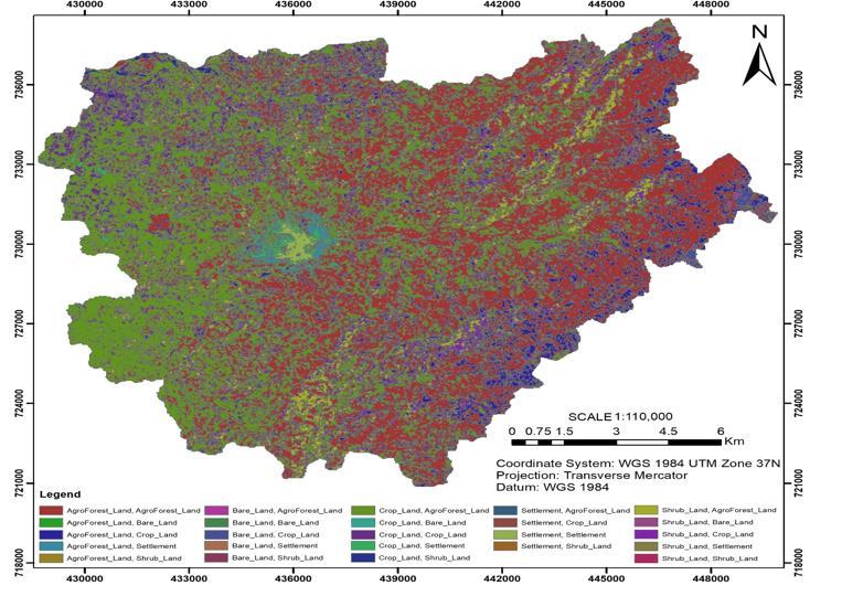
The Change Detection Matrix offers a comprehensive view of how different land use types transition into other categories, showcasing the transformations across the landscape. During the period from 1993 to 2023, notable shifts were observed, exemplified by varying rates of change among different land use types. Between 1993 and 2023, there was an averageincreaseof67%in settlementareasanda23% rise inagroforestrycover. Incontrast,cropland,shrubland,and bare land experienced average decreases of 22%, 28%, and 30%, respectively. This overall analysis of Land Use and Land Cover (LULC)changedetectionrevealedareductioninlandareaacrossthreeLULCcategoriesandanexpansionintwoothers.
To illustrate, consider the state of agroforestry land in 1993, totaling 10,807 hectares. Over the subsequent thirty years, 7,635 hectares, 1,471 hectares, and 10 hectares transitioned from cropland, bare land, and shrubland, respectively, leaving 8,862 hectares unchanged by 2023 (refer to Fig. 6). This matrix provides a detailed snapshot of the dynamic alterations within thelandscape,showcasinghow variouslandusetypes transformedand contributedtotheshiftsobserved over the studied period. It delineates the intricate patterns of conversion and stability among different land use categories, elucidatingtheevolvingnatureoftheAletaWondoWoreda'slandscape.
International Research Journal of Engineering and Technology (IRJET) e-ISSN:2395-0056
Volume: 11 Issue: 02 | Feb 2024 www.irjet.net p-ISSN:2395-0072
Land Use and Land Cover (LULC) changes exert a continuous and multi-scalar impact on various environmental aspects, influencing air and water quality, watershed function, waste generation, wildlife habitat extent and quality, climate, and human health. In the study area, major LULC changes are primarily driven by the intensive engagement of farmers in traditional agroforestry practices and the settlement-related infrastructural developments induced by rapid population growth.
Farmers in the study area actively choose traditional agroforestry for several reasons. The integration of trees provides an additional crop that safeguards against poor harvests, and fruits, staple crops, or timber serve as alternative incomestreamsiftheprimarycropfailsduetoadverseconditions,suchaswetsummersormildwinters.However,thepoor documentationofdataintheregionnecessitatedananalysisofthemajorcropsproducedandsuppliedtothecentralmarket overa17-yearperiod.
The analysis unveiled that, despite other environmental and economic factors, the significant increase in coffee production and improved supply to the central market can be predominantly attributed to the intensification of traditional agroforestry practices. This finding aligns with previous studies in nearby areas, indicating that a fruit-based traditional agroforestrysystemyieldsmultipleproductsandiseconomicallymoreprofitablecomparedtomonocropping(Adane,Legesse etal.2019).From2005to2022,coffeeproductioninthestudyareaincreasedfrom19,132,523quintalsin2005to24,564,178 quintals in 2022, reflecting a growth rate of 28.4%. Concurrently, the supply to the central market surged from 2,667,980 quintals in 2005 to 4,856,419 quintals in 2022, demonstrating an 82% increase. While coffee production exhibited positive growthratesforeveryyearexcept2010,2012,and2015,thesupplytothecentralmarketconsistentlyincreasedthroughout the entire study period. Thus, intensive traditional agroforestry emerges as a primary driving force for the overall rise in coffeeproductionandsupplyinthestudyarea(Fig.7).
International Research Journal of Engineering and Technology (IRJET) e-ISSN:2395-0056
Volume: 11 Issue: 02 | Feb 2024 www.irjet.net p-ISSN:2395-0072
Production in quantal Supplied to Market
Within similar physical features and neighboring locations, studies have confirmed that agroforestry practitioners utilizing mango trees report various environmental benefits. These advantages include enhanced soil fertility, reduced crop damagebywind,andimprovedmicroclimatesforcropsandlivestockduetoshading.Farmersincorporatingmangotreesinto theirpracticeshaveexperiencedmoresignificantbenefitscomparedtothosewhodonot(GocheraandWorku2022)
In essence, traditional agroforestry systems have been deeply rooted in the Aleta Wondo and Sidama region, constitutingacrucialelementof locallivelihoods. Thisisparticularlyevidentintheirsignificant roleinfosteringthethriving cultivationofcoffeeintheshadedunderstoryoftheregion Thesesystemsplayacrucialroleinpreservingecosystemservices and biodiversity corridors, maintaining traditional agroecological practices on small-scale family farms. These farms, characterized by adiverse mix of crops, livestock,vegetablegardens, and productive forest areas, areessentialforlocalfood and income generation. The practices of farmers provide valuable insights into the synergy between agroforestry shifts, indigenousknowledge,andthesustainablelandscapeofAletaWondo.
Utilizing geospatial technologies, this study scrutinized Land Use and Land Cover (LULC) changes within the study area.TheanalysisofLandsatimageryspanning fouryearsdelineatedsignificantshiftsinlandcover.Notably,agroforestland experienced a substantial increase, potentially impacting microclimates and local livelihoods. Over the study period, agroforestry land expanded by 7,337 hectares, while cropland, shrubland, and bare land decreased by 5,601 hectares, 1,835 hectares, and 377 hectares, respectively (1993 to 2023). The drivers behind these changes involved transitioning from monocultureto agroforestrypractices, rapid populationgrowth, and expanding built-upareas. Whilethe rise inagroforestry land presents economic, social, and environmental potential, exponential settlement growth raises concerns about land degradation,resourceoveruse,andclimateimpacts.Addressingthehighruralpopulationgrowthmightnecessitateexploring off-farmemploymentopportunities,especiallyfortheyouth.
Policy interventions, especially in managing traditional agroforestry systems, offer nature-based solutions for biodiversity conservation and ecosystem maintenance. Further research focusing on traditional agroforestry practices is crucial for understanding their role in nature management, combating land degradation, and enhancing global climate resilience.
In summary, this study highlights the intricate relationship between land use, human activities, and environmental repercussions. Strategic policies and ongoing research are essential for sustainable land management and mitigating the adverseimpactsofevolvinglandcoverpatterns
International Research Journal of Engineering and Technology (IRJET) e-ISSN:2395-0056
Volume: 11 Issue: 02 | Feb 2024 www.irjet.net p-ISSN:2395-0072
Availability of data Availableinthemanuscript
Declarations ; Theauthorsdeclarethattheyhavenoknowncompetingfinancial interestsorpersonalrelationshipsthatcouldhaveappearedtoinfluence theworkreportedinthispaper.
Credit authorship and contribution statement
Adamu Assefa: Conceptualization, Methodology, Software, Formal analysis, Data Curation, Writing- Original draft preparation. Gedion Tsegay: Software, Visualization, Validation, Data curation Writing - Review & Editing. Hu Xialin: Conceptualization,Writing-Review&Editing,Visualization,Supervision,Projectadministration,Fundingacquisition
References
Abebe,M.,K.T.DerebewandD.O.Gemeda(2019)."Exploitingtemporal-spatialpatternsofinformalsettlementsusingGISand remotesensingtechnique:acasestudyofJimmacity,SouthwesternEthiopia." EnvironmentalSystemsResearch 8:1-11DOI: https://doi.org/10.1186/s40068-019-0133-5
Abrham, T., H. Beshir and A. Haile (2020). "Sweetpotato production practices, constraints, and variety evaluation under differentstoragetypes."FoodandEnergySecurity 9:12DOI:https://doi.org/10.1002/fes3.263.
Adane, F., A. Legesse, T. Weldeamanuel and T. Belay (2019). "The contribution of a fruit tree-based agroforestry system for householdincometosmallholderfarmersinDaleDistrict,SidamaZone,SouthernEthiopia." AdvPlantsAgricRes 9(1):78-84 DOI:https://doi.org/10.15406/apar.2019.09.00415
Bassett, T. J. and K. B. Zuéli (2000). "Environmental Discourses and the Ivorian Savanna." Annals of the Association of AmericanGeographers 90(1):67-95DOI:https://doi.org/10.1111/0004-5608.00184.
Borrell, J. S., M. K. Biswas, M. Goodwin, G. Blomme, T. Schwarzacher, J. S. Heslop-Harrison, A. M. Wendawek, A. Berhanu, S. Kallow,S.Janssens,E.L.Molla,A.P.Davis,F.Woldeyes,K.Willis,S.DemissewandP.Wilkin(2019)."EnsetinEthiopia:apoorly characterizedbutresilientstarchstaple."AnnalsofBotany 123(5):747-766DOI:https://doi.org/10.1093/aob/mcy214.
Chang, Y., K. Hou, X. Li, Y. Zhang and P. Chen (2018). "Review of Land Use and Land Cover Change research progress." IOP Conference Series: Earth and Environmental Science 113(1): 012087 DOI: https://doi.org/10.1088/17551315/113/1/012087.
Chughtai,A.H.,H.AbbasiandI.R.Karas(2021)."Areviewonchangedetectionmethodandaccuracyassessmentforlanduse land cover." Remote Sensing Applications: Society and Environment 22: 100482 DOI: https://doi.org/10.1016/j.rsase.2021.100482.
Churches, C. E., P. J. Wampler, W. Sun and A. J. Smith (2014). "Evaluationof forest cover estimates for Haiti using supervised classification of Landsat data." International Journal of Applied Earth Observation and Geoinformation 30: 203-216 DOI: https://doi.org/10.1016/j.jag.2014.01.020.
Congalton, R. G. (1991). "A review of assessing the accuracy of classifications of remotely sensed data." Remote Sensing of Environment 37(1):35-46DOI:https://doi.org/10.1016/0034-4257(91)90048-B
Deribew,K.andD.Wana(2019)."LanduseandforestcoverdynamicsintheNorth-easternAddisAbaba,centralhighlandsof Ethiopia."EnvironmentalSystemsResearch 8 DOI:https://doi.org/10.1186/s40068-019-0137-1
Feng, H., S. Wang,B.Zou, Y. Nie,S. Ye, Y.Dingand S.Zhu(2023)."Landuseand coverchange(LUCC)impactsonEarth’secoenvironments: Research progress and prospects." Advances in Space Research 71(3): 1418-1435 DOI: https://doi.org/10.1016/j.asr.2022.09.054
International Research Journal of Engineering and Technology (IRJET) e-ISSN:2395-0056
Volume: 11 Issue: 02 | Feb 2024 www.irjet.net p-ISSN:2395-0072
Geeraert, L., E. Hulsmans, K. Helsen, G. Berecha, R. Aerts and O. Honnay (2019). "Rapid diversity and structure degradation overtimethroughcontinuedcoffeecultivationinremnantEthiopianAfromontaneforests."BiologicalConservation 236:8-16 DOI:https://doi.org/10.1016/j.biocon.2019.05.014
Geist, H., W. McConnell, E. F. Lambin, E. Moran, D. Alves and T. Rudel (2006). Causes and Trajectories of Land-Use/Cover Change. Land-Useand Land-Cover Change: Local Processes and Global Impacts. E. F. Lambin and H. Geist. Berlin, Heidelberg, SpringerBerlinHeidelberg: 41-70.
Gessesse,A.,T.Alemie,T.FeyisaandA.Jemal(2016)."ImpactAssessmentofLandUse/LandCoverChangeonSoilErosionand Rural Livelihood in Andit Tid Watershed, North Shewa, Ethiopia." Archives of Current Research International 3: 1-10 DOI: https://doi.org/10.9734/ACRI/2016/22268
Gochera, A.and H. Worku (2022)."Mangiferaindica (L.)treeas agroforestry component: Environmentaland socio-economic roles in Abaya-Chamo catchments of the Southern Rift Valley of Ethiopia." Cogent Food & Agriculture 8(1): 2098587 DOI: https://doi.org/10.1080/23311932.2022.2098587
Gómez,M.U.,A.L.Bueno,A.C.León,J.I.UribeBernalandS.A.HernándezAguirre(2022)."Traditionalagroforestrysystems:a methodological proposal for its analysis, intervention, and development." Agroforestry Systems 96(3): 491-503 DOI: https://doi.org/10.1007/s10457-021-00692-w
Haggar, J., D. Pons, L. Saenz and M. Vides (2019). "Contribution of agroforestry systems to sustaining biodiversity in fragmented forest landscapes." Agriculture, Ecosystems & Environment 283: 106567 DOI: https://doi.org/10.1016/j.agee.2019.06.006
Iiyama,K.,E.Takahashi,J.Lee,H.Mon,M.Morishita,T.KusakabeandC.Yasunaga-Aoki(2017)."Alkalineproteasecontributes to pyocyanin production in Pseudomonas aeruginosa." FEMS microbiology letters 364 DOI: https://doi.org/10.1093/femsle/fnx051
Jamala, G. (2013). "The Scope and Potentials of Fodder Trees and Shrubs in Agroforestry." IOSR Journal of Agriculture and VeterinaryScience 5:11-17DOI:https://doi.org/10.9790/2380-0541117.
Jiang,L.,X.DengandK.C.Seto(2013)."Theimpactofurban expansiononagriculturallanduseintensityinChina." LandUse Policy 35:33-39DOI:https://doi.org/10.1016/j.landusepol.2013.04.011.
Jose, S. (2012). "Agroforestry for conserving and enhancing biodiversity." Agroforestry Systems 85(1): 1-8 DOI: https://doi.org/10.1007/s10457-012-9517-5
Kassa,H.,A.Abiyu,N.Hagazi,M.Mokria,T.KassawmarandV.Gitz(2022)."ForestlandscaperestorationinEthiopia:Progress andchallenges."FrontiersinForestsandGlobalChange 5 DOI:https://doi.org/10.3389/ffgc.2022.796106
Kindu, M., T. Schneider, D. Teketay and T. Knoke (2016). "Changes of ecosystem service values in response to land use/land cover dynamics in Munessa-Shashemene landscape of the Ethiopian highlands." Sci Total Environ 547: 137-147 DOI: https://doi.org/10.1016/j.scitotenv.2015.12.127
Lambin, E. F. and H. J. Geist (2003). "Regional Differences in Tropical Deforestation." Environment: Science and Policy for SustainableDevelopment 45(6):22-36DOI:https://doi.org/10.1080/00139157.2003.10544695.
Landis,J.R.andG.G. Koch(1977)."Themeasurementofobserveragreementforcategoricaldata." Biometrics 33 1:159-174 DOI:https://doi.org/10.2307/2529310.
Manderso,T.(2019)."EvaluatingImpactofLand-use/land-coverchangeonSurfacerunoffusingArcSWATmodelinSoreand Gebawatershed,Ethiopia." DOI:10.7176/JEES/9-10-02.
Marentes, M. A. H., M. Venturi, S. Scaramuzzi, M. Focacci and A. Santoro (2022). "Traditional forest-related knowledge and agrobiodiversity preservation: the case of the <i>chagras</i> in the Indigenous Reserve of Monochoa (Colombia)."
2024, IRJET | Impact Factor value: 8.226 |
International Research Journal of Engineering and Technology (IRJET) e-ISSN:2395-0056
BiodiversityandConservation 31(10):2243-2258DOI:https://doi.org/10.1007/s10531-021-02263-y
Meragiaw, M., Z. Woldu and B. R. Singh (2022). "Land use and land cover dynamics and traditional agroforestry practices in WonchiDistrict,Ethiopia."PeerJ 10:e12898DOI:10.7717/peerj.12898.
Negassa, M., D. Mallie and D. Gemeda (2020). "Forest cover change detection using Geographic Information Systems and remote sensing techniques: a spatio-temporal study on Komto Protected forest priority area, East Wollega Zone, Ethiopia." ENVIRONMENTALSYSTEMSRESEARCH 9 DOI:https://doi.org/10.1186/s40068-020-0163-z.
Nziguheba,G., J.B.Adewopo,C.Masso,N.L.Nabahungu, J. Six, H. Sseguya,G. TaulyaandB. Vanlauwe(2021). "Assessmentof sustainable land use: linking land management practices to sustainable land use indicators." International Journal of AgriculturalSustainability 20:265-288DOI:https://doi.org/10.1080/14735903.2021.1926150.
Pantera, Α., M. R. Mosquera-Losada, F. Herzog and M. den Herder (2021). "Agroforestry and the environment." Agroforestry Systems 95(5):767-774DOI:10.1007/s10457-021-00640-8.
Pellikka,P.K.E.,V.Heikinheimo,J.Hietanen,E.Schäfer,M.SiljanderandJ.Heiskanen(2018)."Impactoflandcoverchangeon aboveground carbon stocks in Afromontane landscape in Kenya." Applied Geography 94: 178-189 DOI: https://doi.org/10.1016/j.apgeog.2018.03.017
Quandt, A., H. Neufeldt and K. Gorman (2023). "Climate change adaptation through agroforestry: opportunities and gaps." CurrentOpinioninEnvironmentalSustainability 60:101244DOI:https://doi.org/10.1016/j.cosust.2022.101244
Shimizu,K.,T.OtaandN.Mizoue(2019)."DetectingForestChangesUsingDenseLandsat8andSentinel-1TimeSeriesDatain TropicalSeasonalForests."Remote.Sens. 11:1899.
Shukla, J. and S. Dhyani (2023). Potential of Traditional Agroforestry Systems for Intensification of Agriculture and Meeting Global Goals: Lessons from Asia and Africa. Agroforestry forSustainableIntensificationof Agriculturein Asia and Africa. J. C. Dagar,S.R.GuptaandG.W.Sileshi.Singapore,SpringerNatureSingapore: 665-683.
Sidamareport(2020).RegionalFinancebureauofSidama,yearlreportof2020
Taddese, S. (2020). "ASSESSMENT OF SOIL EROSION AND LAND USE LAND COVER CHANGE USING RUSLE MODEL, GIS AND REMOTESENSING:ACASESTUDYOF WOMBEYAWATERSHED,A."InternationalJournalofCurrentResearch 11:5730-5738 DOI:10.24941/ijcr.35603.07.2019.
Tesfahunegn, G. (2013). "Soil Quality Indicators Response to Land Use and Soil Management Systems in Northern Ethiopia's Catchment."LandDegradation&Development 27 DOI:https://doi.org/10.1002/ldr.2245
Tk,K.(2014).TROPICALHOMEGARDENS: 365-375.
Torralba, M., N. Fagerholm, P. J. Burgess, G. Moreno and T. Plieninger (2016). "Do European agroforestry systems enhance biodiversity and ecosystem services? A meta-analysis." Agriculture, Ecosystems & Environment 230: 150-161 DOI: https://doi.org/10.1016/j.agee.2016.06.002.
Wana,H.,G.Kudama,A.Tilahun,F.Dereje,N.Ababulgu,G.Gobena,B.TadeseandB.Chalchisa(2022)."Indigenousknowledge and traditional agroforestry practices and their implications for food security: thecaseof Wollega Zones, Western Ethiopia." GeoJournal 88:2787-2798DOI:https://doi.org/10.1007/s10708-022-10772-8.
Ware,M.,T.Matewos,M.Guye,A.TuraandY.Mohammed(2023).Spatiotemporalcharacteristicsandtrendanalysisofrainfall andtemperatureinSidamaRegionalState,Ethiopia
Woldesenbet, A. B., S. D. Wudmatas, M. A. Denboba and A. G. Gebremariam (2020). "Enset-based land use land cover change detection and its impact on soil erosion in Meki river watershed, Western Lake Ziway Sub-Basin, Central Rift Valley of Ethiopia."EnvironmentalSystemsResearch 9(1):37DOI:https://doi.org/10.1186/s40068-020-00198-x
Volume: 11 Issue: 02 | Feb 2024 www.irjet.net p-ISSN:2395-0072 © 2024, IRJET | Impact Factor value: 8.226 | ISO 9001:2008 Certified Journal | Page628
International Research Journal of Engineering and Technology (IRJET) e-ISSN:2395-0056
Volume: 11 Issue: 02 | Feb 2024 www.irjet.net p-ISSN:2395-0072
Wu, C., B. Du, X. Cui and L. Zhang (2017). "A post-classification change detection method based on iterative slow feature analysis and Bayesian soft fusion." Remote Sensing of Environment 199: 241-255 DOI: https://doi.org/10.1016/j.rse.2017.07.009
Yang, X., X.-Q. Zheng and L.-N. Lv (2012). "A spatiotemporal model of land use change based on ant colony optimization, Markovchainandcellularautomata."EcologicalModelling 233:11-19DOI:https://doi.org/10.1016/j.ecolmodel.2012.03.011
Zebene, A. and G. I. Ågren (2007). "Farmers’ local knowledge and topsoil properties of agroforestry practices in Sidama, SouthernEthiopia."AgroforestrySystems 71(1):35-48DOI:10.1007/s10457-007-9087-0.
2024, IRJET | Impact Factor value: 8.226 |