150YearsofISV 1874-2024
ISV Board wish all Members a safe and happy festive season
Patron:HerExcellencyProfessortheHonourableMargaretGardnerAC
TheInstitutionofSurveyorsVictoria 206/370StKildaRoad,MelbourneVIC3004 T(03)93269227Eisv@isvic.org.au Wwww.surveying.org.au
TraverseispublishedbytheInstitutionof SurveyorsVictoria
Inthisissue This issue rounds out 2024 and our 150th sesquicentenary year of ISV. The cover shows the unveiling of the newly replaced and repositioned Henry Wade memorial plaque in Sunbury. This being just one of ISV's achievements this year, along with numerous other activities and awards some of which recognised within this issue.
We have a series of technical and historical articles kindly provided by members, including the abstract to “A proposition for the Hamlet of Portsea and Port Phillip Bay” by David Boyle. The full paper is available through the website. Also included is snapshot of the recent member survey results, and the always fascinating 50yr flashback.
Articlesandphotographsarewelcomedfor consideration
Editor:RileyUlbrich isv@isvic.org.au
Administration:IanThomas ithomas@isvic.org.au
Creative:OliviaTrabanino-Marchand admin@isvic.org.au
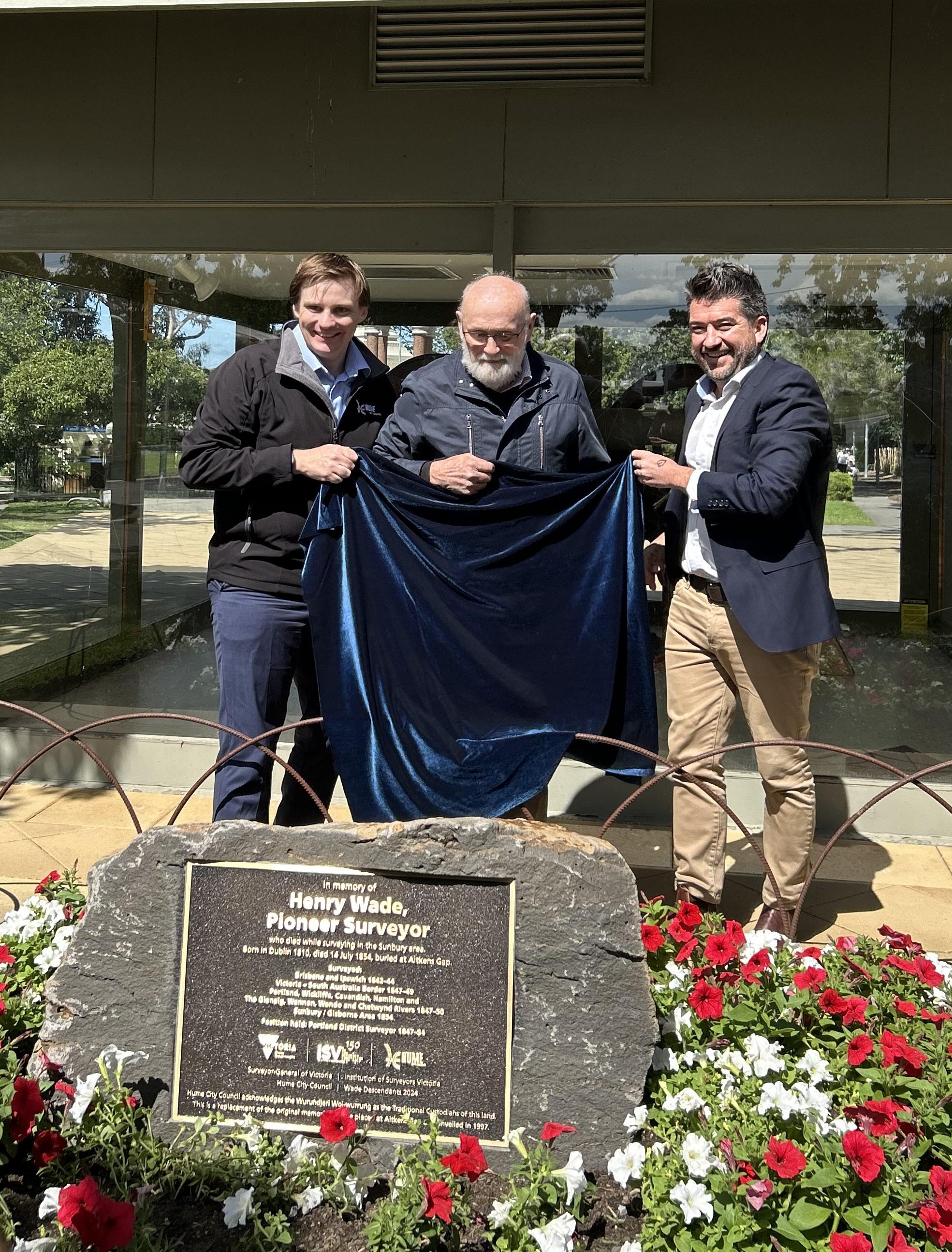
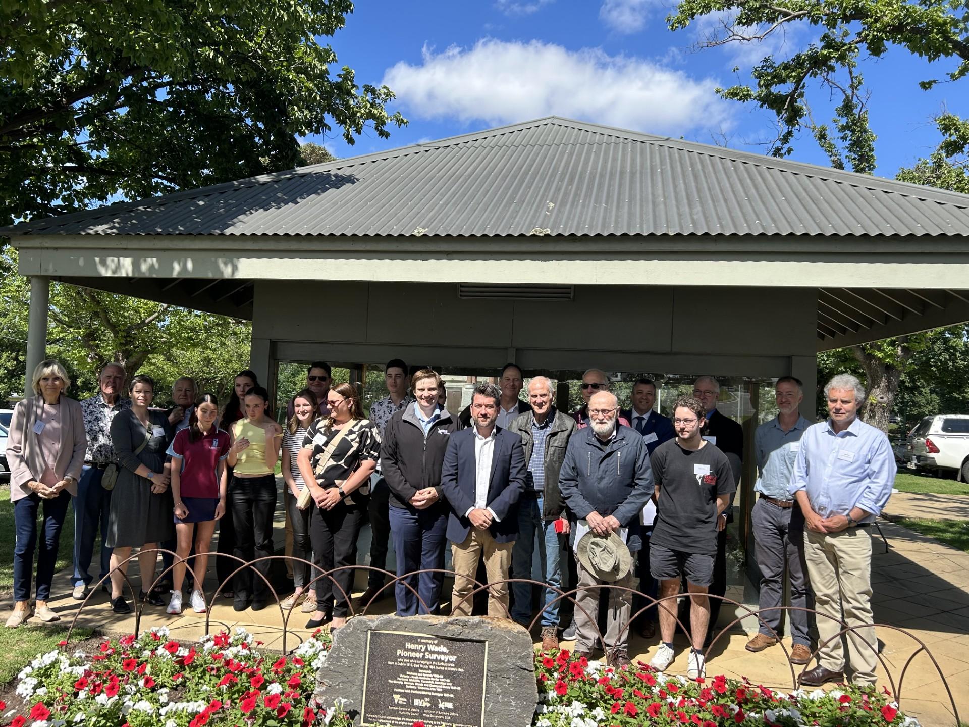
Cover: This new plaque, unveiled at the Village Green memorial park in Sunbury on 10 December 2024, honours pioneering surveyor Henry Wade (1810 – 1854) who died while working in the field near Sunbury. The original plaque was installed in a more remote setting outside of Sunbury and had been stolen. It’s creation was a collaboration of the ISV, Wade family descendants and VicRoads. Following two years’ work, a new plaque was designed and a central location decided through a similar collaboration with ISV, the Wade family, Surveyor General Victoria and Hume Council and recognises our 150 logo and our work towards the replacement during our Sesquicentennial year, the final Sesquicentenary event in a year of celebrations and history.
I sincerely wish you all an enjoyable holiday break and a prosperous 2025. Riley Ulbrich
TheviewsexpressedinTraversearenotnecessarilyendorsedbyThe InstitutionofSurveyorsVictoria.Noresponsibilityisacceptedbythe publishers,theeditororprinterfortheaccuracyofinformationcontained inthetextoradvertisements.Advertisementsmustcomplywiththe relevantprovisionsoftheTradePracticesAct1974.Responsibilityfor compliancewiththeActrestswiththeperson,company,oradvertising agencysubmittingtheadvertisement. Neitherthepublishernortheeditor acceptsresponsibilityforadvertisements.
ThepublicationisproducedbyTheInstitutionofSurveyorsVictoriawith theunderstandingthatisnoengagedinprovidinglegalorother professionalservices. Iflegalorotherexpertassistanceisrequired,a competentprofessionalpersonshouldbeengaged
Contents Traverse issue 336 December 2024
03 From the President
04 Least Squares - Dr Jane Cooke
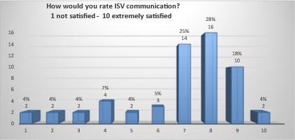
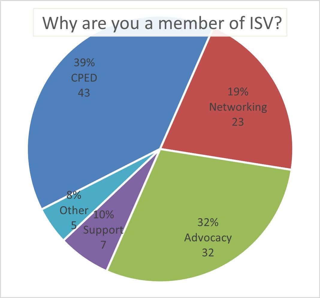
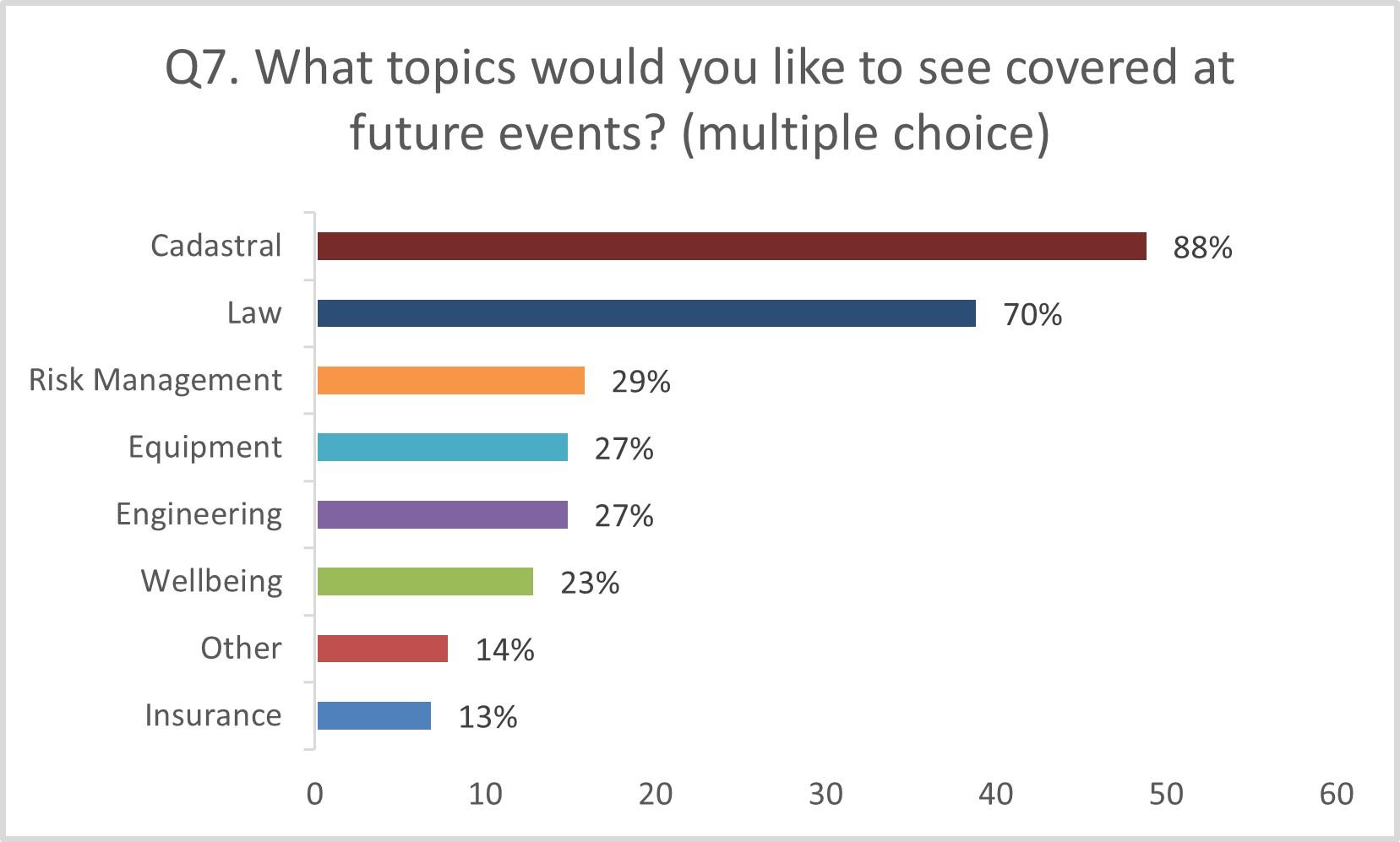
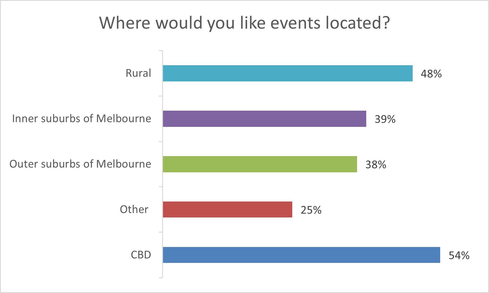
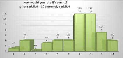
06 Member Survey Results Snapshot
07 ISV Crest History
08 Gippsland and Glenelg Group Event Report
09 Kilmore Event Report
10 Leading the charge in digital Innovation - University of Melbourne
12 Least Squares Continued
13 ISV Survey Equipment Workshop Launched Report
14 John Montgomery Coane and the competition that made Canberra
18 2024 Colin Middleton Luncheon Report
19 Calendar of Events
20 50 Year Flashback!
21 Awards
22 A proposition for the Hamlet of Portsea and Port Phillip Bay - David Boyle
24 Defining the Shrine Vista Viewing Point - Tom Champion
26 Airborne gravity survey
27 Henry Wade Memorial Plaque unveiled in Sunbury
FromthePresident TheSesquicentenaryyearhasnow cometoaclose.Afterstartingwitha presentationfromDrRogerFraseron theRemarkableMr.RobertEllery,our inauguralPresident,eachevent throughouttheyearhasincludedan elementofthehistoryofsurveying.The closingmonthsoftheyearhaveseen severalsmallerfocusedseminars lookingateventsandthepeoplethat haveshapedourhistory.
Specificeventshavetakenplaceineach oftheregions:
TheGippslandGrouptouredthePort AlbertMaritimeMuseumandthe AlbertonCemetery,hearingfromlocal historians,followedbyaSeminar. TheGlenelgGrampiansGroupmetin HamiltonandheardaboutAtkinsons SpecialSurveyandthestatusofthe remainingOldLawLand.
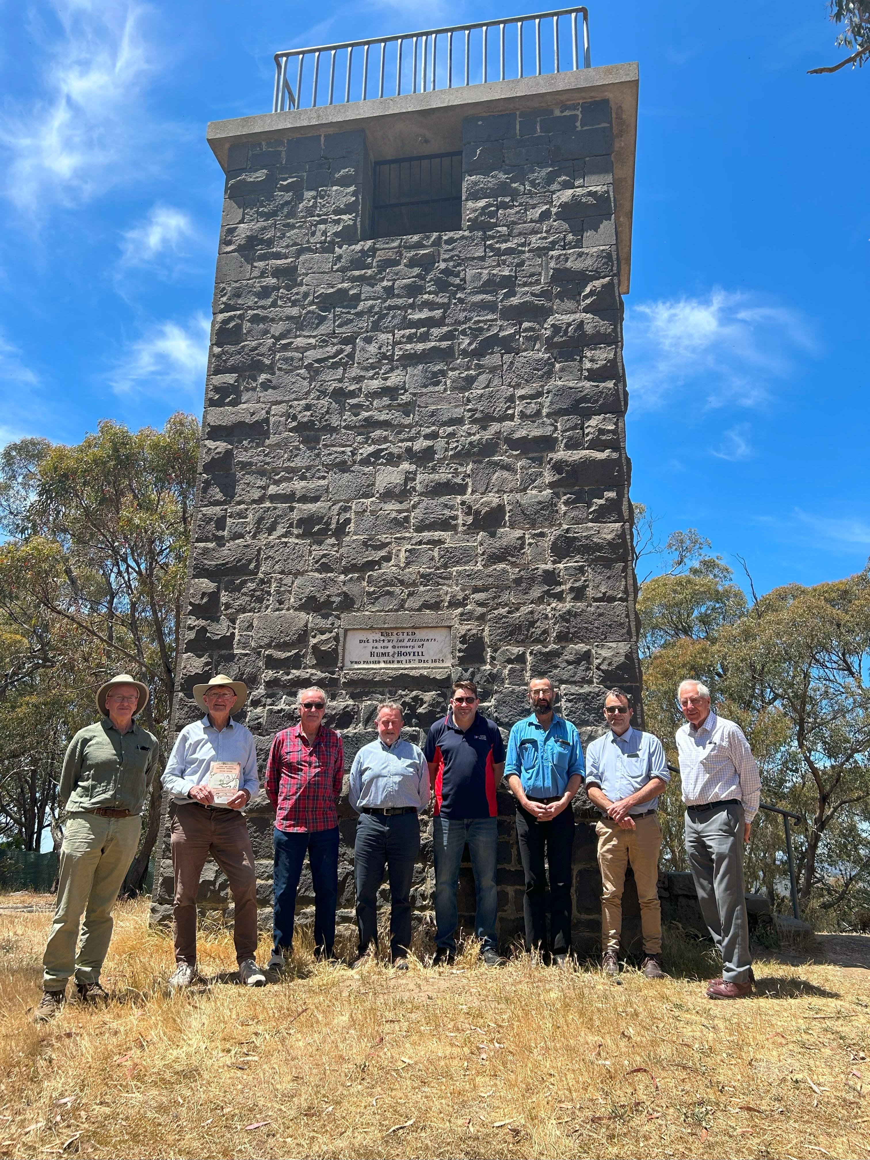
TheNorthCentralGroupincludeda touroftheVictorianHeritageSurvey MuseumatKilmore,whichiswell worthavisit (pleasechecktheir Facebookpageforcontactdetailsand openingsastheyareopenonselected days),afterwhichthegroupheard fromLancePritchardonthe TerminationPointoftheHumeand HovellExpedition.
Therewasalsoagatheringatthe magnificentHumeandHovellTower Monument.
ISVagainsupportedtheConferral CeremonyfornewlyLicensed Surveyors.Congratulationsgotothe thirteenLicensedSurveyors acknowledgedonthenight.
TheChristmasSeminarwasheldatMt DerrimutGolfCourseinDerrimutwhich isnamedaftertheIndigenouschief Derrimutwhodiedin1864.Heisnoted forhiswarningtotheearlysettlersof animpendingattackbyup-country tribesmen,perceivedaspartofhisduty ofhospitality. Thishospitalityisstill enjoyedtodayandassurveyorsIam surewewillhavealargerparttoplayin supportingIndigenouspeopleinthe future.Theattendeesheardaboutthe ShrineVistaoriginpointandthenew surveymarkplacedatthislocation, andfromEddieCichocki,Deputy SurveyorGeneralVictoria,about pioneersurveyorHenryWade,Alifein Surveyingwhichwasaprecursortothe unveilingofanewplaque.
Thefinalfunctionfortheyearwasat Sunburyfortheunveilingofthenew plaquetocommemoratethelifeand workofHenryWade(referfront cover).TheoriginaloneatAitkens GapontheCalderFreewayhadbeen stolen.
Theunveilingwascarriedoutby JoshBullMP,StateMemberfor Sunbury,MayorJarrodBell,Cityof HumeandPeterWaderepresenting theWadefamily,whohadtravelled downfromQueensland.
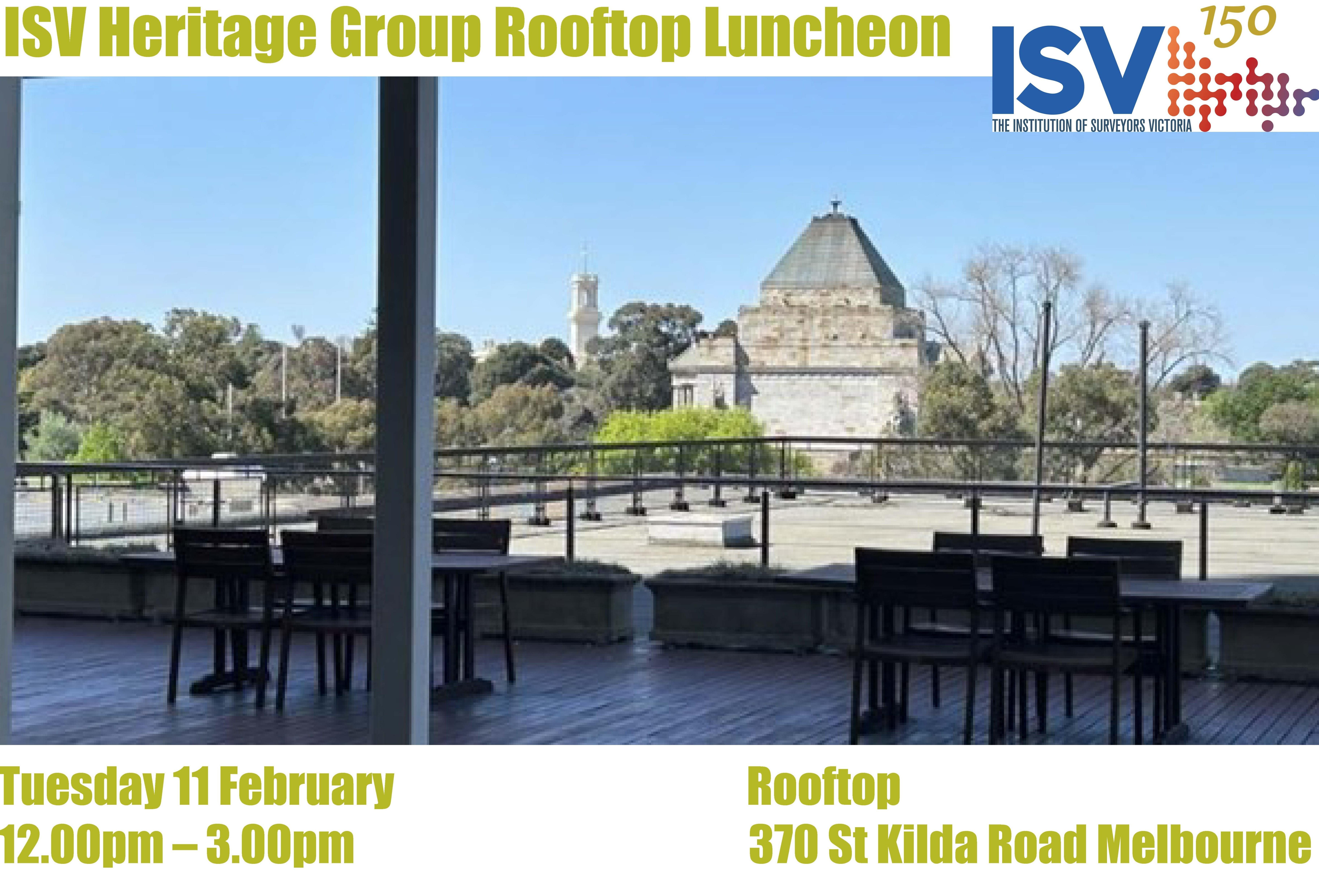
Tobegin2025thereareacoupleof functionsontherooftopattheoffice forouryoungerandoldermembers. Pleasecheckoutthecalendarof eventsaswebegintheyearwith renewedenergy.
TheRegionalConferencefor2025is beingrunbytheMurrayGroupon2 to4MayinWangaratta,sopleaseput aplaceholderinyourcalendarswhile theprogramisbeingfinalizedbythe Group
Itistimetolooktothefutureand whatthenext150yearswillhold. Willartificialintelligencemakemajor changes?Ithinknot,asthereisstilla considerableamountofsurvey knowledgeneededforsurveying naturalboundariesanda considerableamountofOldLaw Land,andnotjustunderroadsand drainageinfrastructure.
Iwishyouallthebestforamerryand joyousChristmasandasafeand HappyNewYear.
ProudlySupportedby:
PlatinumSustainingMember:C.R.KENNEDY
SilverSustainingMember:Acsis
GeneralSustainingMembers: LightwaveTechnology,Listech,TechRentals
LeonWilson,PresidentISV
Leastsquares-DrJaneCooke FollowingRiley'sarticlelastAuguston LeastSquaresandCadastralSurveying regulations,Iwanttoexplorehow surveyorsuseLeastSquaresinthefield andoffice.I'mnotamathematician,but I'veworkedwithsurveyorsformanyyears. Thistechniqueiscrucialtosurveying, eventhoughitissometimesoverlooked.
Leastsquaresinthefield–froma simpleresectiontoTraverseprogram Leicafirstexplainedleastsquareswitha resectionsetupinanearlynewsletter duringtheSystem1200days.Thisclear explanationisstillusedtodaytoteach newsurveyorsaboutleastsquares. Inthismethod,thesurveyorsetsupthe totalstationandmeasuresdistancesto threeknowntargetpoints.Aftereach measurement,thetotalstationʼsposition isnʼtfullyknown.Afterthefirst measurement,thestationcouldbe anywherealongacirclecenteredonthe firsttargetpoint.
Whenmeasuringthesecondtarget,the positionisnarrowedtotwopossible locationswherethetwocirclesintersect. Thesurveyorcanthendeterminethe correctlocation.
Thethirdmeasurementintroduces redundancy,withthreecircles intersecting.However,because measurementsareneverperfect,the circleswonʼtintersectexactly.
Tofindthe"best"locationofthetotal station,weuseleastsquarestominimize errorsandgetthemostaccurateestimate.
Butwhatdoesitmeanto“usethe methodknownasleastsquares”?Let's assumethatthemostlikelylocationofthe totalstationisnearthecenterofthe triangleformedbythetargetpoints.To start,wecalculatethecoordinatesofthis centralpoint.Fromthere,wecan computethedistancefromthis"guessed" positiontoeachtargetpoint(the "computed"distance).Thiscomputed distancewilldifferfromtheactual measureddistances(the "observed"distances).Bycomparingthe computedandobserveddistances,wecan calculatethedifference,orthe"residual," foreachtargetpoint.Next,wesquare eachresidualandsumthemuptoobtain thetotalsumofthesquaredresiduals.
Thisapproachisusedintheresection method,whereatleastthree measurementstoknownreferencepoints arerequired.Theleastsquaresmethodis alsoappliedthroughoutCaptivate software,wheremultipleobservationsare takenandabest-fitresultisneeded.
LeastSquaresisapplyinganuneven distributionoferrorsthroughouta properlyconstrainedprojectbasedon redundantobservations-providing varyingdegreesoffreedom-withthe attemptoffindingthemostprobable andrealisticlocationsofpoints.
Thedefinitionaboverequires redundantobservations,theseare collectedviathesetsofanglesapp, measureforesightorwithinthe traverseapp.Thedatacanbe downloadedintoInfinitysoftwareor processedinthefieldusingthe Traverseapp.
Traverseapp Thetraverseappisusedtomeasure pointsinasurveyandassessthe precisionofthemeasurementsmade withinthetraverse.Ifthetraverseis closedthenthesurveyorlooksatthe miscloseandifitiswithinthe acceptableparameterstheycanchoose toadjustthemeasurementsandclose thetraverse.TheTraverseAppusesthe CompassruleorBowditchmethodas themostappropriateforsurveyinga networkofstationsinthefield.
TheAppisflexibleandletsyouchoose yoursequenceofbacksightsand foresights–addmultipleforesight pointsandruneachmeasurementpast atolerancecheckpriortostoring.Aset upiscompletedthenaforesightis measured.Theprocessiscontinued untiltheTraverseiscompletedand closed,youwillbeabletoseeyour angularmiscloseontheresultspage. Theresultsarethenpresentedor exportedinareport.
Whenyoudownloadthedatafromthe fieldintoInfinity,thesurveyoffice softwarefromLeicaGeosystems,you canreprocessyourtraverseusing CompassorLeastSquaresplusalso combineallyourfielddatafromthe level,TPSandGPStogether. Processingsetsofredundant observationsaccordingto mathematicallywell-definedrulesto findthebestsolutionandreliable qualityindicators.
Themeasurementor“observation” datafromthefieldisimportedinto Infinity.AnyTraversecreatedfromthe fieldisalsoimported.Thekeyaspectof Infinitythoughisthatall
observationscanbeunpicked andrebuiltintoanewtraverse oradjustedwithothertraverses inabiggernetwork.
Forexample,ifdatahasbeen collectedthroughMeasured ForesightsorSetsofAngles applications,thenyoucan choosewhethertousethe resultofthoseapplications (thatis,thereduced observations)ortheraw measurementsthemselves.
Thisfeatureallowsall observationsandcontrolpoints tobecombinedintoanetwork asrequired.
ATraversecanberecalculated inInfinityusingleastsquares.
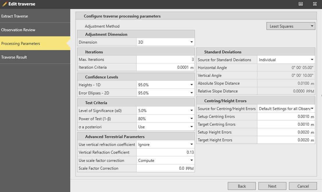
Foreachjobtheparametersare setaccordingtothejob requirementsandobservation types,seeFigure1.Infinityhas separateprocessingsectionsfor Leveldata,TPSobservations andGPSRTKorstaticdata. Thesurveyorcanimporteach typeofdataandprocessthem. Therebyfindingandeliminating grosserrors beforeasuitablesetofx,y,z baselinecomponentsor reducedheightsarereadyto adjust.
Theaimistoorganizethefield measurementsinsuchawayso thatanetworkofindependent baselinescanbeformed.
CRKennedyprovidetailored trainingcoursestolookatthe combinednetworkadjustment settingsandthecombinationof multipledatasets.
Infinitysupportsthefollowing typesofadjustment:
1. 3D(Full)adjustment:thistype canbeusedtoadjustpureGNSS dataorasmallTPS3Dnetworkor combinedGNSS,TPSandLevel data.SeeFigure2onpg12.
2. 2Dadjustment:thistypeis moresuitabletoadjustTPSdata ignoringtheheightdimension.
3. 1Dadjustment:thistypecan beusedtoadjustpureleveldata orcombinedleveland trigonometricheightdifferences.
Articlecontinuedonpage12.
Figure1.InfinityLeastSquaressettingsinTraverseadjustment.
2024 ISV Membership Survey - Results TheCrestoftheInstitutionofSurveyors FromSurveyPracticeHandbookPart3–Section2.5.8:
ThecrestwasregisteredasatrademarkbyThe InstitutionofSurveyors,N.S.W.,Incorporated,on24 September1924andisrenewedeveryfourteenyears. Withtheagreementofthe"Proprietor",TheInstitution ofSurveyors,N.S.W.,thiscrestwasadoptedbyThe InstitutionofSurveyors,Australia,whentheFederal Institutionwasformedin1952.
Theinsigniaofthecrestcomprise:Topleft-hand quadrantcontainsthe"CruxAnsata"whichwasthe ancientEgyptiansymbolforimmortality;alsothe PhoenixwhichwasthesignusedbyPlatofor immortality.
Topright-handquadrantcontainsstarsoftheSouthern CrossimposedontheCrossofSt.Georgewhichwasthe nationalensignofEnglandpriortotheUnionwith Scotland.Intheregistrationthe"Proprietor"undertook thatthecrossdeviceappearinginthemarkwouldnot beprintedinred.Lowerleft-handquadrantshowsa mapoftheworldorglobe,withAustraliaprominently displayed.Lowerright-handquadrantisapyramid encircledbyaserpent.Nodoubtthepyramidrecords thefactthattheoriginofgeometrygoesbacktothe ancientEgyptians.
Theserpentissometimesusedtomeanakey(in Greek),hencethekeytogeometry.ThemottoMEDEIS AGEOMETPETOSEISITOwastakenfromthe inscriptionovertheportalofPlato'sAcademy. Theliteralmeaningis"Letnoonewithoutskillin geometriaenter",theprimarymeaningoftheGreek wordgeometriabeing"measurementofearth".
ISVhasusedthiscrestonvariouscertificates, Minutes,plaques,websiteandothersettingsfor manyyears.ISVconfirmedapprovalfromISNSW Boardthisyearforthecontinuedandongoinguseof thecrest.
IntroducingnewMember-HarrisonMacpherson-Wood HarrisoncompletedhisSecondaryeducationinWodongain2013and beganworkingasacasualfieldassistanceforSpiirebasedintheir Alburyoffice.Surroundedbyawealthofknowledgeandexperiences andbuildingskills,hewassimultaneouslystudyingforhisBachelorʼs degreeonline.
Apassionforaviationwasmergedwithsurveying,obtaininghis RemotePilotLicence(RePL)andHarrisonisnowtheChiefRemote PilotforSpiire,whereUAVoperationshavegrownsignificantlyandhe isgratefultobepartofthatadvancedtechnology.
WithaBachelorSpatialScience(Honours)(Surveying)andhisRemote PilotLicence,HarrisoniscurrentlyinaProfessionalTraining Agreement,buildinghisknowledgeofcadastralsurveying.
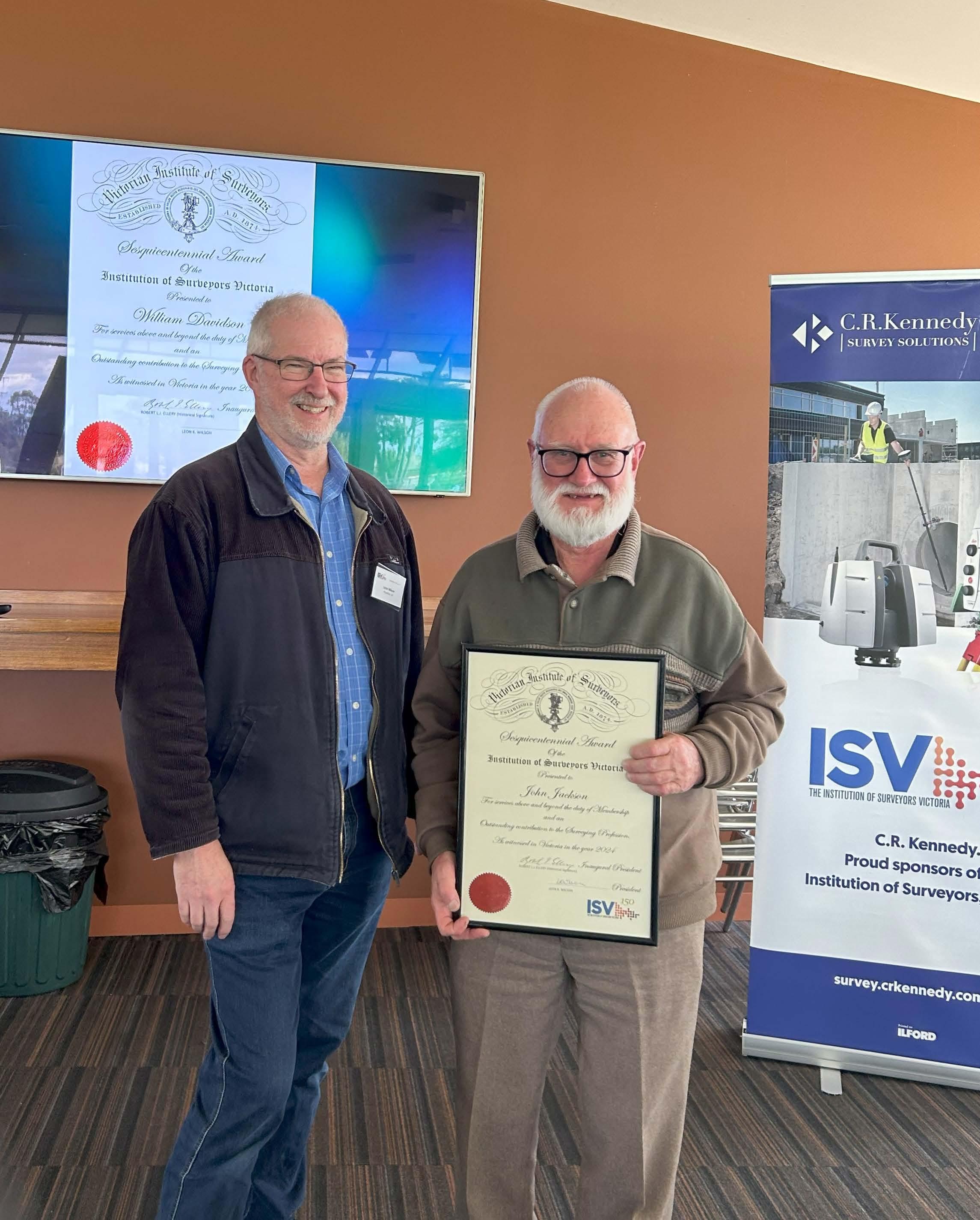
Turning150–ISVGippslandGroupCelebrates@PortAlbert Thewarmthandsuccessofthis eventathistoricPortAlbert,which beganwiththeGippslandGroup AGMandMorningTea,wasdue muchtothefamilyconnections withintheregionandinparticular totheworkoftheirlocalChairand RegionalDirectorJonathan Neilson.Thegroupheardfrom localhistoriansEsmeRushand BillHobsonatthePortAlbert MaritimeMuseumbeforeaconvoy totheAlbertonCemetery,oneof theearliestsurveyedinVictoria, wherehistorianandTrustee, MalcolmMayspokeatlength aboutthestories,curioushistory andarrangementofthecemetery, Thegroupthenmovedtoalunch andSeminaratYarramFootball Club,weretheyhadtheopportunity toheararegionalupdatefrom Surveyor-GeneralofVictoriaCraig Sandy,apresentationon sustainableharvestingofhardwood onpubliclandbyEmmaLeslieof HeartwoodUnlimited,atechnical presentationbasedonlocalhistoric surveysfromJonathanNeilson,and anISVupdatefromthePresidentof ISVLeonWilson,whotookthe opportunitytopresentawell earnedSesquicentennialAwardto JohnJackson,whohascontributed somuchtotheprofessionwithin theregionandthisgroup.An excellentafternoonteafollowed withvaluablenetworking opportunities.
TURNING150–ISVGlenelgGrampiansGroupCelebrates Itwasgreattoseethe turnoutfromtheGlenelg GrampiansGroupfortheir MiniSeminarand Networkingeventatthe historicRoxburghHousein HamiltoninOctober.The factthatHamiltonwas originallysurveyedby pioneeringsurveyorHenry Wadewasnotlostonthe audiencewhichwastreated toapresentationfrom PresidentLeonWilsonon theartoftracingbackland ownershiptotheoriginal SpecialSurveyseffecting WesternVictoriastill impactingonownershipof uniqueparcelsoflandtoday.
DeputySurveyorGeneralEddie Cichockithenpresentedanupdate tailoredfortheregionalmembersand greatandpositivediscussionswere hadaroundthetablewhilethisexpert wasabletolistenandadvise.A highlightoftheeveningwasa presentationbythePresidentofa SesquicentennialAwardtonewly
timeregionalenthusiastRogerWhyte,
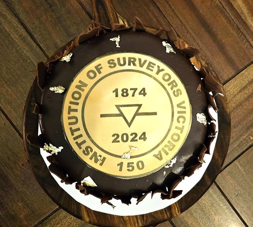
whohadputsomuchtimeintotherestorationofthe WadeWhitememorialontheVictoriaSABorderand hisworkwithinthelocalgroup.Asanaddedbonusa cakecelebratingthe150thappearedtoppedwith anediblegoldplaqueinthedesignofthe Sesquicentenarypinandwassurroundedinearthy chocolateshavings..Thanksmustgotolocal secretaryJamesWatsonandlocalISVrepresentative ontheSRBVandISVDirectorClintJosephfortheir enthusiasmalongwithallwhotravelledtojoininthe
night.
special
LocalhistoriansEsmeRushandBill Hobsonsharetheirextensiveknowledge ofearlymappinganddevelopmentofthe regioninfrontoftheirrareGovernmemt Gazettecollection.
MalcolmMaysharesthesadstoryoflocalpioneerRanald MacalisteratAlbertonCemetery.
JonathanNeilson,regionalChairandDirectorofISVpresentsonalocalproject referencinglayeredhistoryandpersonallocalknowledge.
ISVPresidentLeonWilson presentsSesquicentennialAward toJohnJackson
Followingvaluablediscussionseffectingregionalexperiences, the Networkingandenjoymentcontinuedwithacelebratorygoldleaf chocolatecakeandagroupphotomarkingtheoccasion.
ThistimeitwasISVDirectorandRegional representativeRogerWhytewhowastherecipient ofaSesquicentennialAwardfromISVPresident LeonWilson.
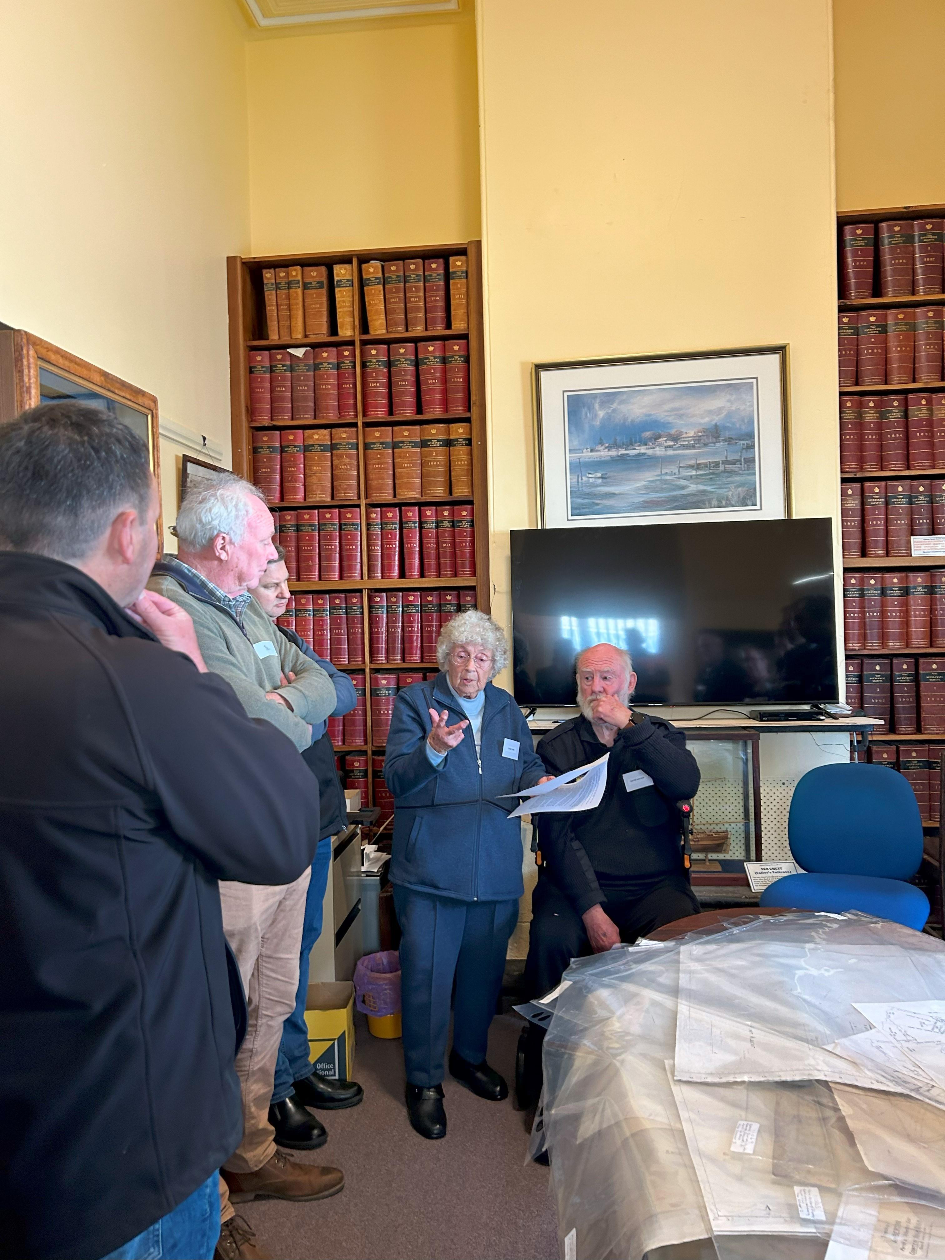
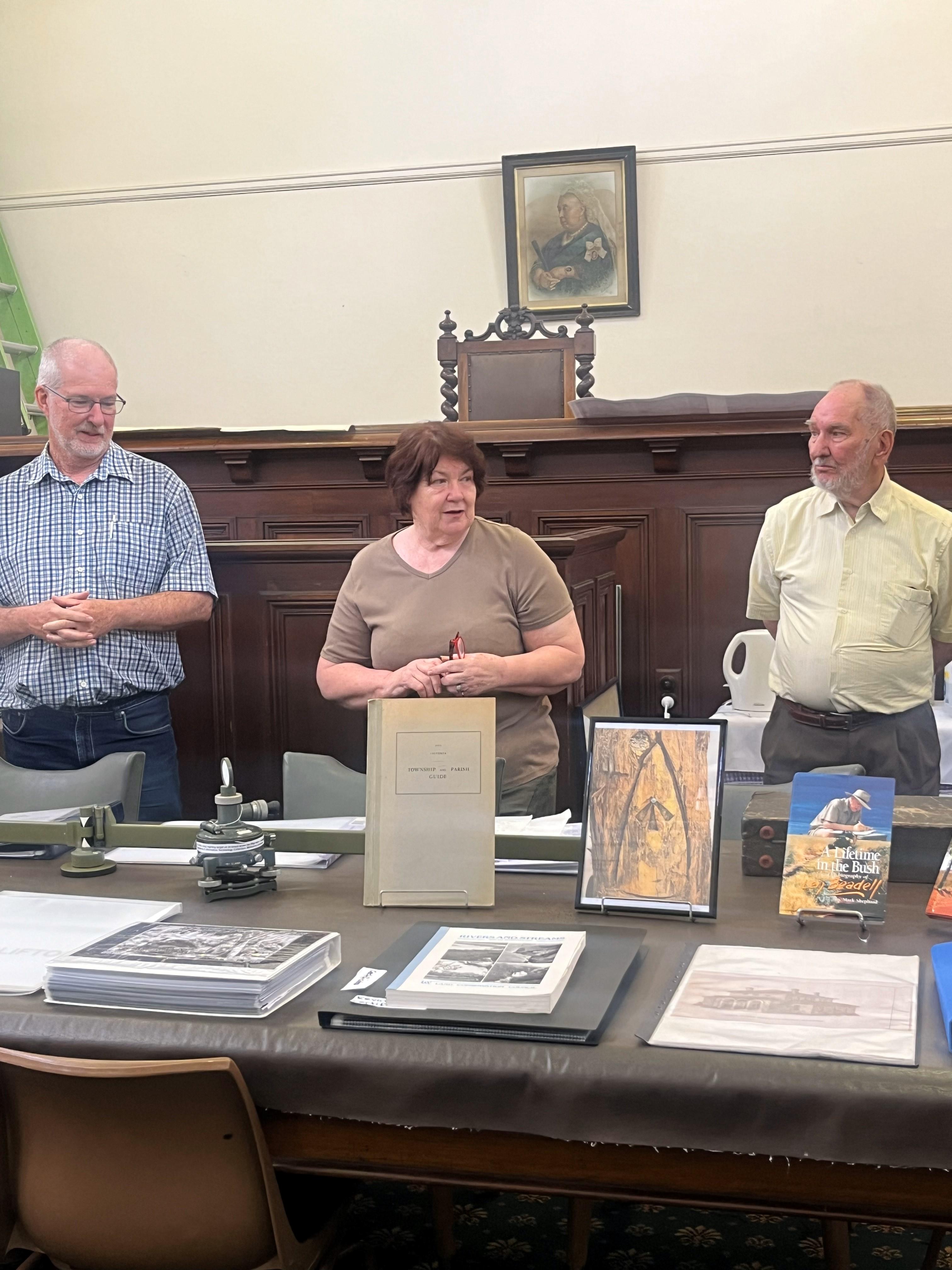
ISVNORTHCENTRALGROUPCELEBRATES@KILMORE TheISVNorthCentralGroupcelebrated ISVʼsSesquicentenaryonNovember20 inKilmore,anhistoricallysignificant centralVictoriantown. Theeventfeaturedrichhistorical contentandtheoldergenerationof surveyorswerewellrepresented.
ThedaybeganattheHumeandHovell monument,atwo-storeybluestone structurebuilt100yearsagoinDecember 1924perchedonabushlandhill overlookingthetown.Themonument wasconstructedtomarkthe100th anniversaryoftheexpeditionpassing throughtheregion,andthisyearmarks the200th.Attendeesthenvisitedthe VictorianHeritageSurveyMuseumfor afternoontea,wherehostsDianneand JohnLeQuiniatshowcasedanextensive collectionofsurveyingequipment,plans, anddocuments.Manystoriesofsurveys andequipmentofthepastwereshared bytheattendeesatbothvenues.
ISVDirectorinProfile-EvanWebster AtKilmoreTrackside,ISV PresidentLeonWilsonwelcomed everyone,followedbySurveyorGeneralCraigSandyʼsupdate, includingePlanadoption, mandates,andproposed registrationfeeincreasesfor LicensedSurveyors.Historian LancePritcharddelivereda presentationmarkingthe200th anniversaryoftheHume& Hovellexpedition,bookending thedaynicely.
Thedayconcludedwithdinner anddrinksforthe20orso attendees,providingarelaxed settingforinformaldiscussions withpresentersandorganisers. Theintimatescaleoftheevent fosteredengagementand meaningfulexchanges,makingit amemorablecelebrationofISVʼs milestoneanniversary
EvangraduatedfromRMITUniversitywithaBachelorofAppliedScience (Surveying).PriortothisEvancompletedaBachelorofEngineering(Civil)/ BachelorofBusinessatSwinburneUniversity.Aftercompletinghistertiary studiesEvanworkedforapropertydevelopmentfirmwherehewas responsibleforthedeliveryoflargebroadacreresidentialsubdivisions. Evanthenspentseveralyearsworkingabroadforoneofthelargest surveyingcompaniesintheUnitedKingdomwhereheworkedallover EnglandandScotland.Hewasinvolvedinanumberofhighprofile projectsincludingthe2012OlympicsGamesinLondonandthe2014 CommonwealthGamesinGlasgow.During2015Evanwasawarded registrationasaLicensedSurveyor.HecurrentlyrunsWebsterSurvey Groupwhichisafamilyownedbusinessthatwasestablishedin1979.Evan isthethirdgenerationofhisfamilytobeaLicensedSurveyorinVictoria. HisGreat-GreatGrandfatherCapewasapioneersurveyorinthelate 1800ʼsandwasthefirstpersontosurveymanypartsofMelbourneand ruralVictoriawhilehisfatherNeilisalsoaLicensedSurveyor. CurrentlyEvanisChairofSurveyingTaskForce,whichisabodythat encouragesstudentsandpeopleseekingacareerchangetoconsiderLand Surveyingasacareer.Hehaspresentedatmanycareereventsand UniversityOpenDaysaswellasgivingguestlecturestostudentsatRMIT.
GatheringattheHumeandHovelltower monumentKilmore
PresidentISVLeonWilsonwithSurveyMuseum committeemembersDianneandJohnLeQuiniat tellingthestoryoftheSurveyMuseumanditʼs remarkablelocationintheoldKilmoreCourtHouse.
Digital Lab - Digital TwinSolutions: Leading the Charge in Digital Innovation By Dr Davood Shojaei and Prof Abbas Rajabifard
society,suchasdisastermanagement, climatechange,energyoptimisation,and pollutioncontrol,smartandfuturecities. TheCentreforSpatialDataInfrastructures andLandAdministration(CSDILA)atthe UniversityofMelbournestandsatthe forefrontofthisinnovationandnewurban analyticaladvancements.Throughits state-of-the-artDigitalLab(D-Lab), CSDILAdeliverscutting-edgeresearchand developmentsolutionsandnewservices, enablinginformeddecision-makingand fosteringsustainablepracticesacross varioussectors.
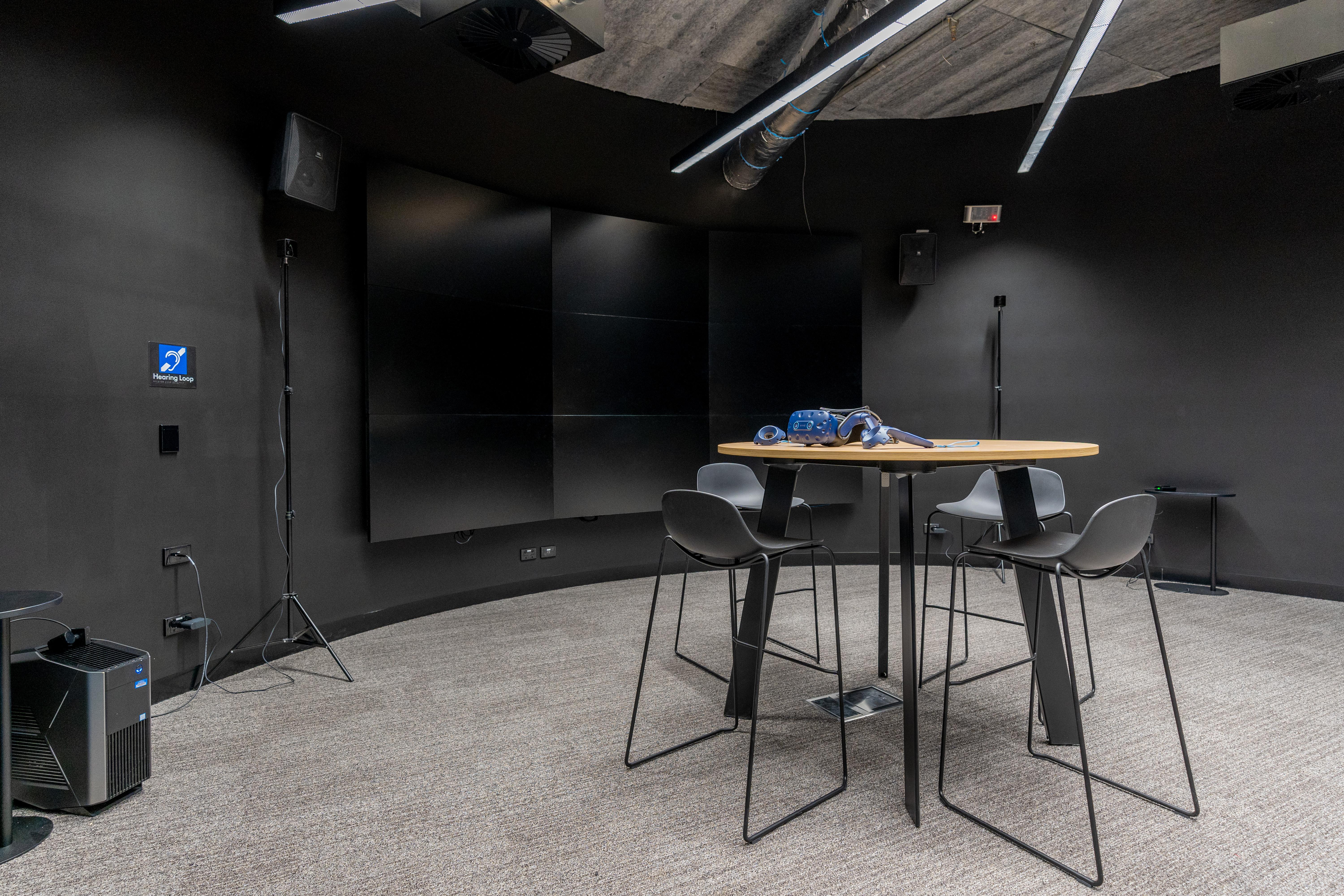
TheD-LabattheUniversityof Melbourneisattheforefrontofdigital transformation,offeringstate-of-the-art technologiesandmethodologiesfordata collection,analysis,andvisualisation. Servingasthetechnologicalarmof CSDILA,D-Labwasestablishedthrougha governmentfundandislocatedatthe cutting-edgefacilitiesatMelbourne Connect. Itisdesignedtofoster innovationindigitaltechnologies, providingacollaborativespacethat bridgesacademia,industry,and government.
disciplines,includingcomputerscience, engineering,healthsciences,city planning,andarchitecture.
AUniqueSpaceforDigitalInnovation TheD-LabʼslocationatMelbourne Connectisnotonlyahubforacademic excellencebutalsoameetingpointfor industryandgovernmentleaders. Itistailoredtoaccommodateadvanced technologiesandmethodologiesthatare shapingthefutureofdigitalsolutions.
TheDigitalLabʼsfacilitiesinclude cutting-edgeequipmentand applicationsforinteractivedata capturing,3Dmodelling,and immersivevisualisation. Beyond justaphysicalspace,theD-Lab embodiesamissiontoconnect industriesandgovernmentswith academiathroughtransformative projects.Byfostering collaborationsandpartnerships, thelabaimstoadvancethe practicalapplicationofresearch, enablingimpactfuloutcomes acrossdiversesectors.
BridgingResearchandPractice TheD-Laboffersauniqueplatform thatconnectsworld-class researchers,nationaland internationalgovernments,and industryleaders.Itregularlyhosts visitorsfromaroundtheglobe, showcasingitscapabilitiesand exploringavenuesfor collaborativeprojects.Through theseinteractions,thelabensures thatitsresearchnotonlyadvances theoreticalknowledgebutalso addressesreal-worldchallenges. Aspartofitsmission,thelab providesdigitalservicesthat supportcontinuedresearchand learning.Thisincludestraining researchers,practitioners,and studentsinthelatestdata-driven technologies.Whetheritʼsfor developingsmartcities,improving landadministration,orsupporting disastermanagement,thelabʼs expertiseissoughtafterby governmentsandindustries worldwide.
Cutting-EdgeServices TheD-Laboffersarangeof servicesthatcatertothediverse needsofitscollaboratorsand partners.Theseservicesinclude:
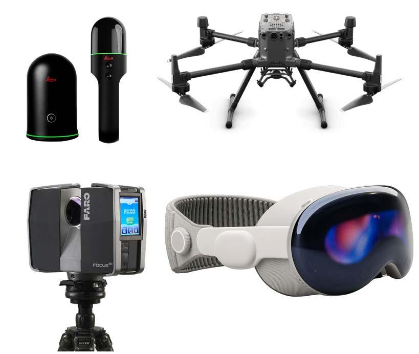
1. DataCollection:Thelab utilisesstate-of-the-artdatacapturingequipment,suchas drones,laserscanners,andvarious sensors,togatheraccurateand high-qualitydata.Thiscapabilityis crucialforcreatingdetaileddigital modelsofphysicalenvironments, whichareessentialforprojects rangingfromurbanplanningto environmentalmonitoring.
2.DataVisualisation:Visualisation technologiesincludingVirtualand MixedRealityandthehologram tableallowthelabtopresent complexdatasetsinanaccessible andintuitivemanner.These technologiesenablestakeholdersto interactwithdatainimmersive environments,enhancing understandingandsupporting decision-makingprocesses.
3.DataAnalysis:Thelabʼsexpertisein dataanalysisenablesthedevelopment ofnoveldigitaltwinsolutions.By integratingreal-timedatawithvirtual models,thesesolutionsprovide powerfultoolsforsimulatingand analysingscenarios,offeringvaluable insightsfordecision-makers.
ResearchAreas TheD-Labactivelysupportsresearch andteachinginawiderangeof domains,including:
•LandAdministration:Developing digitalsolutionstomoderniselandand propertyinformationsystems.
•DigitalTwins:Creatingvirtualreplicas ofphysicalassetstomonitorand optimisetheirperformance.
•SmartandFutureCitiesandBuildings: Advancingthedesignandmanagement ofurbaninfrastructurethrough technology.
•AssetManagement:Enablingefficient monitoringandmaintenanceof infrastructure.
•CityPlanning:Supportingsustainable urbandevelopmentwithdata-driven tools.
•DisasterManagement:Enhancing preparednessandresponsethrough advancedsimulations.
•Health:Leveragingdigital technologiestoimprovehealthcare deliveryandoutcomes. Current Projects
Thelabisactivelyengagedin numeroushigh-impactprojectswith nationalandinternational collaborators. Theseprojectsaddresscritical challengesinareassuchasurban planning,infrastructuremanagement, andlandadministration.Byworking closelywithindustryandgovernment partners,theDigitalLabensuresthat itsresearchhasatangibleimpacton society.
ACallforCollaboration TheD-Labiscommittedtopushingthe boundariesofdigitalinnovation. Itinvitesresearchers,industryleaders, andgovernmentstojoinitsjourneyand exploreexcitingopportunitiesfor collaboration.Whetherthroughjoint researchprojects,technology development,orcapacity-building initiatives,thelabisopentopartnerships thatdrivemeaningfulchange. Ifyouʼrepassionateaboutdigital innovationandlookingtomakea difference,theDigitalLabwelcomesyou toconnectandcollaborate.Letʼscreatea betterfuturetogether!
Findusat:https:// infrastructure.eng.unimelb.edu.au/ digital-lab
LeastSquares-Continuedfrompage5 Infinitycanalsorunadjustments intwosteps.Twoadditional adjustmenttypesaresupported: 2D+1Dand1D+2D.WhenTPSand leveldataarecombined,the pointpositionscanbecomputed fromtheTPSobservations(2D position),whereasthepoint heightscanbecomputedfrom theleveldata(1Dposition). Thus,thetrigonometricheight differencescanbeignored,if necessary.
Dependingontheconstraints imposedonthedata,Infinity supportsthreetypesof adjustment:“InnerConstrained”, “MinimallyConstrained”and “Constrained”.
The“InnerConstrained”option usesaspecialtypeofminimum constraintscalledinner constraints.Inthiscase,the correctionsthepoint coordinatesreceivearethe smallestpossible.Also,all controlpointsareconsideredas unknowns.
The“Minimallyconstrained”option usesuser-definedminimum constraints.Inthiscase,the correctionsthepointcoordinates receivearesmallerthantheones computedinaconstrained adjustment.
Anexampleofminimally constraininganetworkistofixone controlpointinheightandadjust leveldatain1D,ortofixone controlpointinpositionandheight andadjustGNSSdata.
“Constrained”isthecasethatallor morethantheminimumrequired controlpointsarekeptfixedinthe adjustment.Thenetworkshould alwaysbeadjustedasminimally constrainedfirsttocheckfor outliers.
Gooddata,goodmodelerror estimatesandgoodcontrolpoints shouldgiveagoodresult.
Whenimportingyourcontroldata intoanetworkyouneedtoenter thepositionalandheight uncertaintyvaluesofthecontrolin ordertodeterminethe uncertaintiesoftheadjustedpoints inthenetwork.
Thefinalstepoftheadjustmentisto producetherequiredresults.
InVictoriaGNSScontrolsurveys, conventionaltraversinganddifferential levellingmustalladheretoguidelinesto achievesurveycontroluncertainty requirementsoftheproject.Itiscriticalto knowtheuncertaintyofthecontrolyou haveusedandtoapplyitproperlyandto thenexportyourdatainthecorrectformat withalltherelevantmetadata.
Figure2.InfinitytraverseadjustedwithMS60observations(&adjustedscan),GPScontrolandLevelHeights.
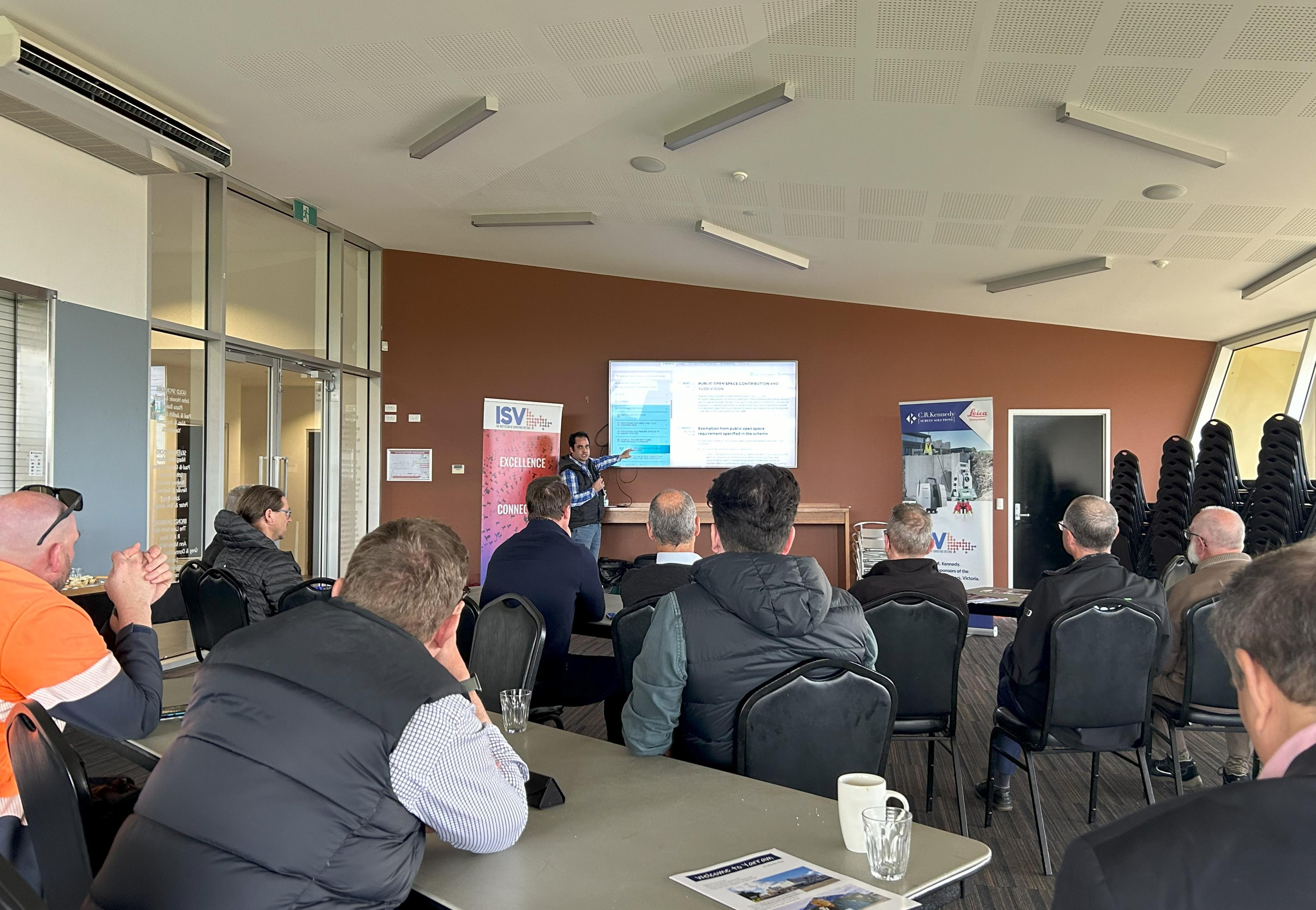
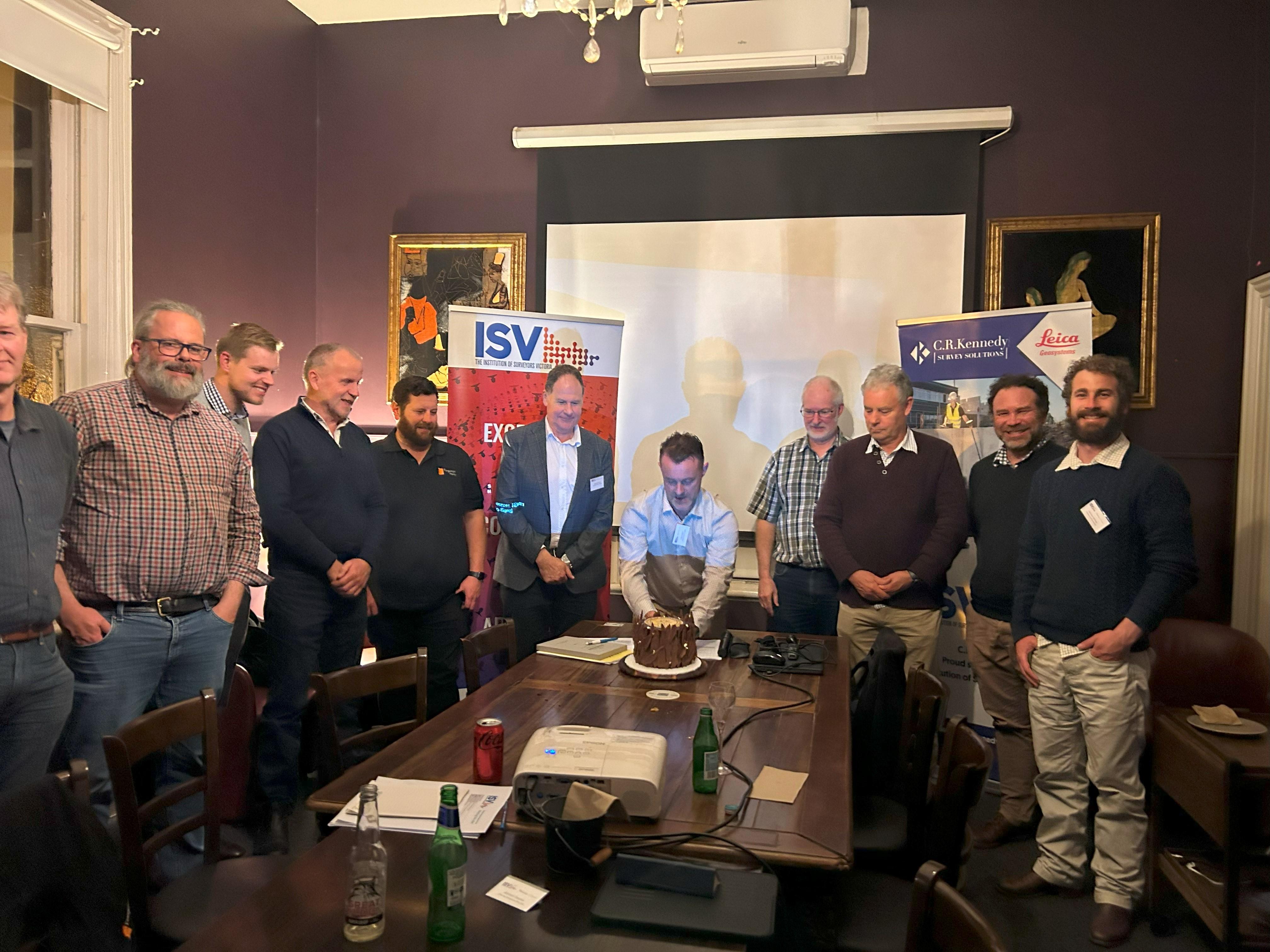
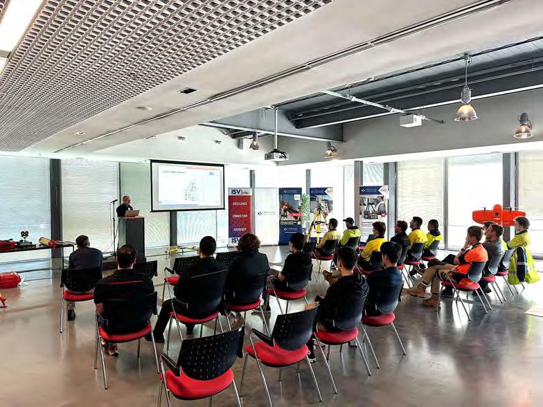
ISVSurveyEquipmentWorkshopLaunched TheISVintroducedanewtrainingdayforits YoungSurveyorslastweek,attractingabroad rangeofPTAcandidates,Graduates,Students andSurveyingAssistants,anditseemstohave instantlyfilledaneededgapwithinindustry. Non-memberswhoarenowseeingthebenefits ofaMembershipwithISValsoattendedanditʼs allthankstothedriveandenthusiasmofISV Director,BadenCoates,joiningforceswithour PlatinumSponsor,CRKennedy,whoprovided theirexcellentvenue,equipmentandstaff,all onhandtopresent,teachandsharetheir knowledgeontipsandtricks,andthecareand maintenanceofsurveyequipment.The responsefromMemberswhoencouragedthe attendanceoftheiryoungerstaffwas extremelypositive,andasnotalltopicsand equipmentcouldbecoveredinthetime, weʼrealllookingforwardtofittingmore opportunitieslikethisintothecalendaragain soon.
YOUNG SURVEYORS TWILIGHT SOCIAL JohnMontgomeryCoaneandthecompetitionthatmadeCanberra TherewasatimeinAustraliaʼs historywhenthenameofJohn MontgomeryCoane,bornin Irelandin1848,legendarysurveyor andconsultingengineer,was inextricablylinkedwiththefinal designchoiceofCanberra.Coane wasauthorisedasasurveyorin 1879,declaredaMunicipal SurveyorandnotedasanEngineer ofWaterSupply. Hewasadmitted asaMemberoftheInstitutionin March1883.
HebeganworkinBenalla, followingabriefperiodasa teacherintheWesternDistrict beforejoiningforceswithGeorge HudsonGranttoformamighty surveyingandengineering businesslaterbasedinMelbourne, thatcoveredmanyareasof expertiseforwhichtheybecame wellknown,includingwater suppliesintownslikeShepparton andDaylesford,levellinginsteep country,subdivisionbothin Melbourneandregionally,private developments,EpsomRacecourse, CapeOtwayForestandirrigation schemes.
ToquotetheAustralianDictionaryof Biography,*“Coane'spapersreadtothe VictorianInstituteofSurveyorsindicate hiswideexperienceandhighstandingin theprofession.Whilehewaspresidentin 1890-91and1905-06,theInstitutelobbied ministersonlegislationandthesurveyorgeneralonthescaleoffees.Coanewas oftencalledasanexpertwitnessin arbitrationsandinengineeringand propertyvaluationdisputes;he representedtheInstituteontheLand Surveyors'Boardin1906-14.Aschairman oftheMinesDepartment'sSludge AbatementBoardin1905-17he influencedtheminingcompaniesto acceptitasanenvironmentalauthority.”
Coanewasforthright,confidentinhisown knowledgeandvision,helpedkeep surveyinguppermostinthepublicʼsmind andwasnotoncebuttwicePresidentof ISV.Hewasnotabuilderofcities,buthe wasacastingvote,apersonalityof singularimportance,thatmeantmuchto theprofessionalsaroundhimandwe shouldrememberhim,especiallyduring ourSesquicentenaryyear.Itwasnʼtthe internationalcompetitionforthedesignof ourNationʼsCapitalthatputhimonthe map,somuchasCoaneputtingCanberra onthemapitself,
aplanthatimmediatelybringstomind WalterBurleyGriffin,ratherthanthe namesofthejudgesthatstrivedforthe mostappropriatechoice,amammoth competitionandanactivitywhichThe Argusrightlyreportedas“gigantic.”
In1911whenMelbournewasstillthe CapitalofthenewNation,the Government,sittinginVictoriaʼsown ParliamentHouse,decidedthattoget theverybestdesigninputitshouldcall foranInternationalDesignforthe Nationʼsnewcapital,Canberra.
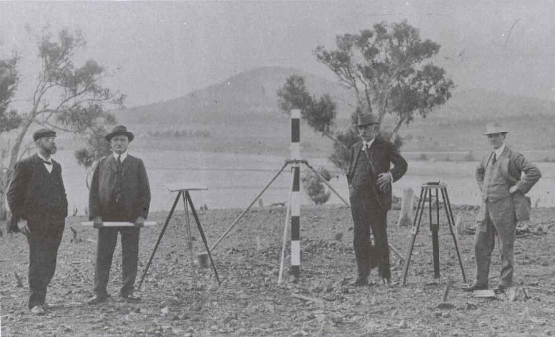
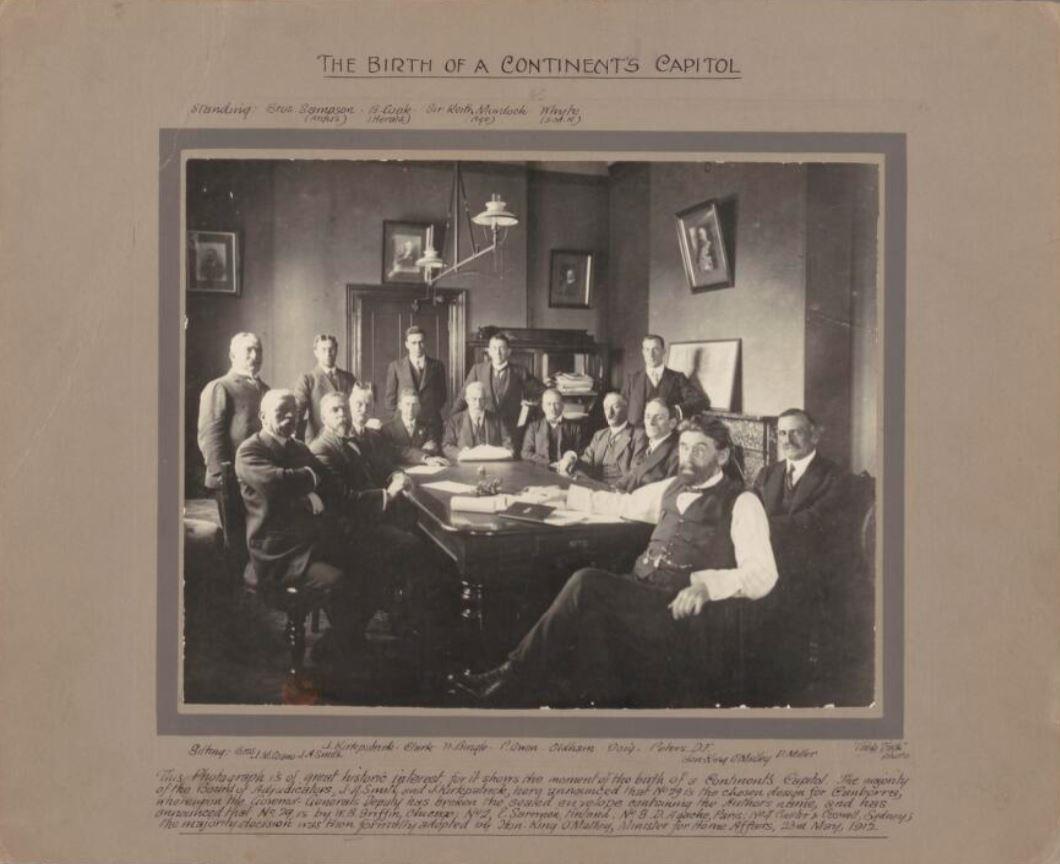
BirthoftheCapital:Assembledatthe announcementofthewinningentryforthe AustralianCapitalCompetitionskilfullyarrangedat theofficeofKingOʼMalley,seated(L-R)areCoane, Smith,Kirkpatrick,possiblyIRClark,andthe GovernorGeneralʼsDeputywiththegiantmultisealedenvelopewithmembersofthepresslooking on.ImagecourtesyNationalLibraryofAustralia.
ThejudgesoftheAustralianCapitalCompetitioninMarch1912:(L-R)Smith,Coane,KirkpatrickonCampHill,Canberra.ImagecourtesyNationalLibraryof Australia
Alreadyfamouslysitedand surveyedbyCharlesScrivener andGeorgeFullerbeginningin 1908,thisvisionaryseatof powerpresentedagreat opportunityforAustraliato proveitselfincapturingcurrent designtrendsincitybuilding, architecture,landscapingand roadconcepts.Thedesignsthat begantoarriveinMelbourne fromaroundtheglobewerejust that.Sweeping,modern, circular,radiating,cross hatchinggridsandexpansive parks.Spaceage,lunar landscapes,wallowinginthe endlessavailabilityofspaceand seeminglyendlesswealthwith whichtobuildon.Ultimately 137designsneededateamof expertsandaftersomedebate ledbyKingOʼMalley,Minister forHomeAffairslinking togethernewlyformed GovernmentDepartmentsand powerbrokers,competition criteriawasdevelopedbythose whohadthecredentialsand knowledge,includingScrivener, butthehurdlesandtempests betweenallthevarious Institutesweretherefromthe beginning. Thejudgesfinallychosenasthe entriesbegantoarriveincluded SydneyarchitectJohn Kirkpatrick,mechanical engineerandPresidentofthe VictoriaInstituteofEngineers JamesAlexanderSmithand FellowoftheInstitutionof SurveyorsVictoria(orVictoria InstituteofSurveyorsasitwas thenknown)JohnMontgomery Coane.Thewholecompetition andtheappointmentofthe judgeswasbothexcitingforthe public,whoanticipatedeach dateanddecisionandtaxingfor thedecisionmakerswhohad eachphasecloselymonitored bythepress.Itseemsclear howeverthatmostpeople understoodtheroleofallthree sciencesinrelationto identifyingaspectacularnew Capital.
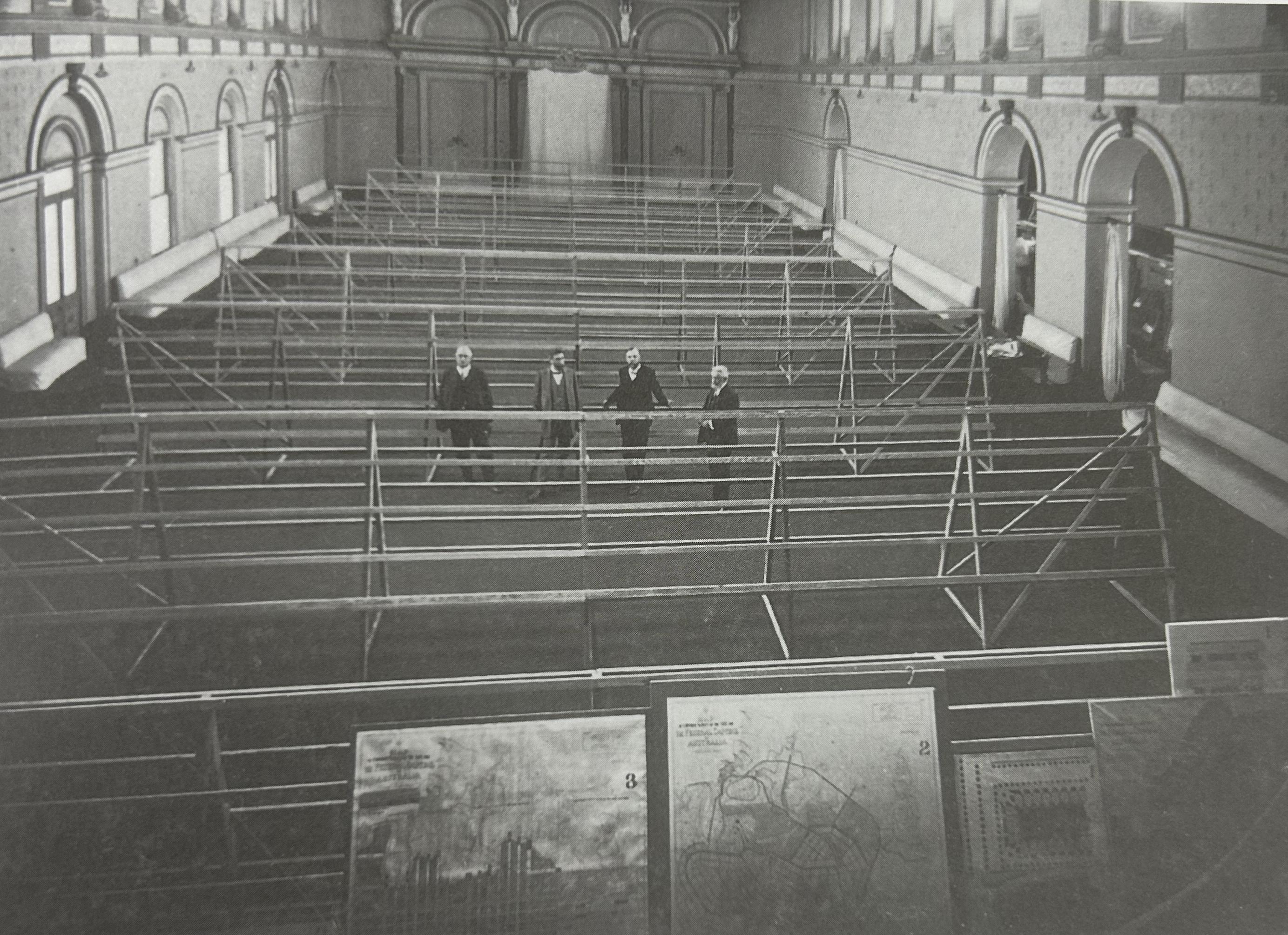
Ofthe137designentries,eachone containedmanygiantplansand drawingstobestselltheconcepts, anunimaginabletaskforthethree judgesbutitwasinthemain systematicwithplussesand minusesaplenty.
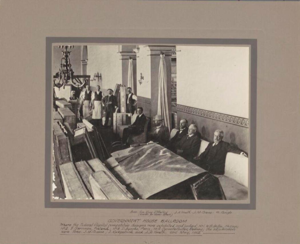
Aspacehadtobefoundforthe enormousquantityofcarefully transportedandpreciousdesigns, manyofwhichsurvivetoday.Itwas decidedthattheBallroomat VictoriaʼsGovernmentHousewasa suitablespaces,andeveryinch includingthesupperannexeswas takeupbyspeciallymadetrestlesto hanganddisplaytheplans,the detailofwhichwasasonereporter putit“amazing.”Theinitialjudging wasswiftandnarrowedtolessthan half,whenphotographsweretaken andthejudgessetoutforCanberra toconsidersuitability.
Excitementwaselevatedinthe pressastherevelationofthe narrowingofthefieldtoaseriesof secretenvelopeswastobeata specialmeetingwithallofficialsand thekeynewspapers,thewinner beingEntryNumber29byWalter BurleyGriffinofChicagoUSA.
Therewasmuchdiscussioninreachingthat decisionandtherewascertainlyveryserious inputfromCoanebeforeandafterwardsin orderforittosucceed.
CoanediedinSydneyin1923aged75,22years CityEngineerforBrightonwhereheisburied, highlyrespectedandincrediblyexperienced, butfromtheISVʼsperspective,Coaneshould remainrecognizedasakeyplayerinthehistory ofourInstitutionandofAustraliaitself.
GovernmentHouseBallroom1912setupforthedisplayofcompetitionentries(L-R)Coane,OʼMalley,Smith andKirkpatrick.ImagecourtesyNationalLibraryofAustralia
Footnotes:*RogerJ.Southern,'Coane,JohnMontgomery(1848–1923)',AustralianDictionaryofBiography,NationalCentreofBiography, AustralianNationalUniversity,https://adb.anu.edu.au/biography/coane-john-montgomery-5692/text9621,publishedfirstinhardcopy1981, accessedonline17December2024.
Furtherrecommendedreading:Canberra1912–plansandplannersoftheAustralianCapitalCompetitionbyJohnw.Reps,MelbourneUniversity Press1997
GovernmentHouseMelbourne,seatedintheforegroundare KingOʼMalley,Smith,CoaneandKirkpatrick.Imagecourtesy NationalLibraryofAustralia
ISV SUMMER SEMINAR 2025 FRIDAY 21 FEBRUARY
Wangaratta Regional Conference 2025 SAVE THE DATE! MAY 2 - 4
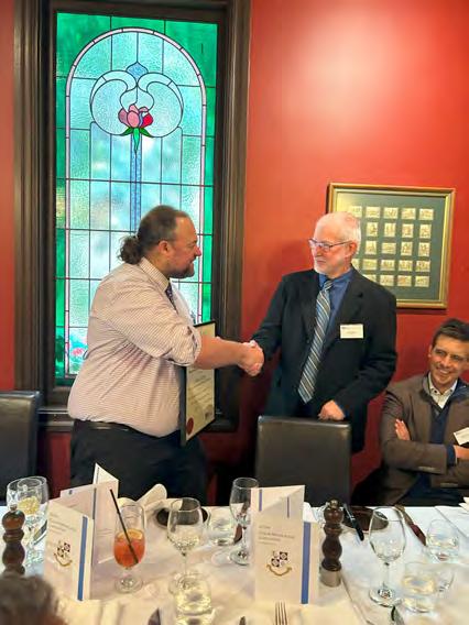
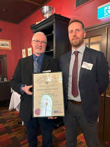
ISV HERITAGE ROOFTOP LUNCHEON 2024ColinMiddletonLuncheon TheColinMiddletonLuncheon, honouringformerSurveyorGeneral1968–1972andISV Memberforsome68years,was againheldinthePrivateDining RoomatthehistoricMitre TaverninMelbourne,where Fellows,PastPresidentsand Surveyors-General,pastand presentareencouragedtobring alongyoungersurveyorsto appreciatetheknowledgeand storiesofthosewhohavelearnt beforethem,tofosterjourneys ofsupportfortheISVallwhile focussingonkeyandcurrent topicswithintheprofession, andprofessionalismitself.
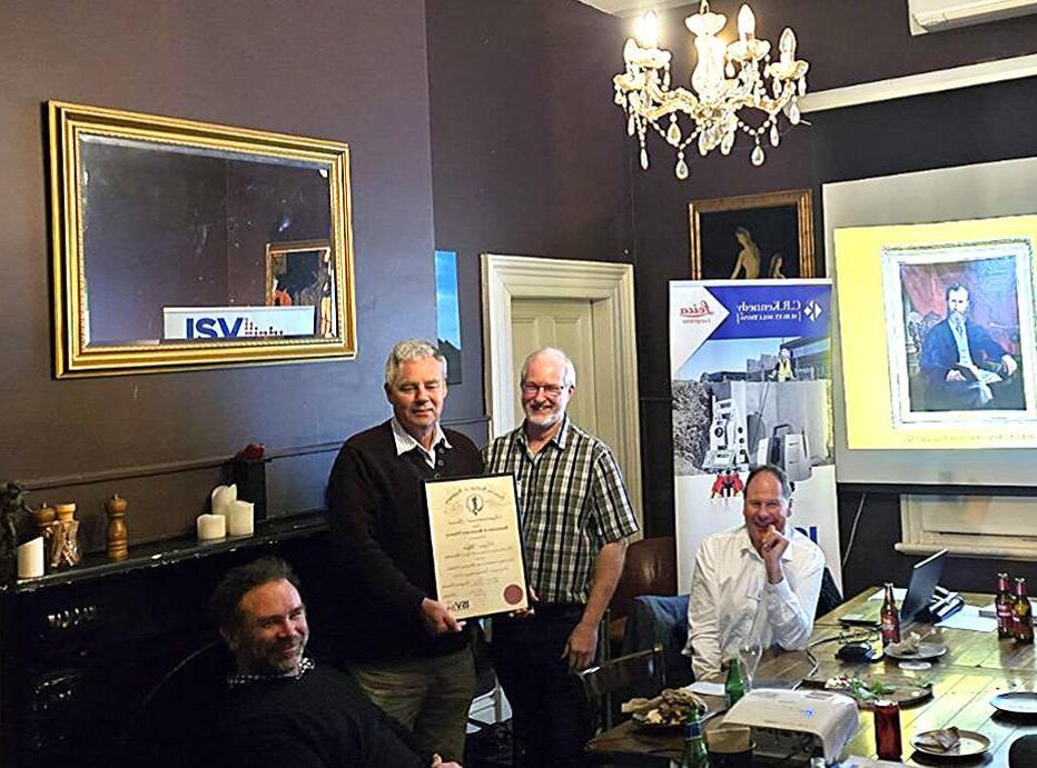
InthePresidentʼsAddressthis year,LeonWilsontookthe opportunitytopresenttwo SesquicentenaryAwards.Oneto PastPresidentAntonyWyatt, whosteppeduptokeepthe Institutionrunningduringaperiod withoutanExecutiveOfficer, combinedwithCovidtimes,andan EmergingLeaderAwardtoMorgan Granger,
forhismaturityandtimelyworkwith theSesquicentenarycommittee.We werefortunatethattheSurveyorGeneralcouldjoinusandenthralledas KenTolemanregaleduswithstoriesof ColinMiddletonhimself.
(Left)PastPresidentAntonyWyattdelightedtoberecognisedwithaSesquicentennialAwardfrom currentPresidentLeonWilson.(Right)LeonWilsonpresentinganEmergingLeader SesquicentennialAwardtoMorganGrangerforhisworkwiththeSesquicentenarycommittee.
Wed 02 ISV Board Meeting
TBA ISV Rooftop Student-lead Seminar
TBC ISV/CSV Joint Webinar
2025ISVCalendar Wed 05 ISV Board Meeting
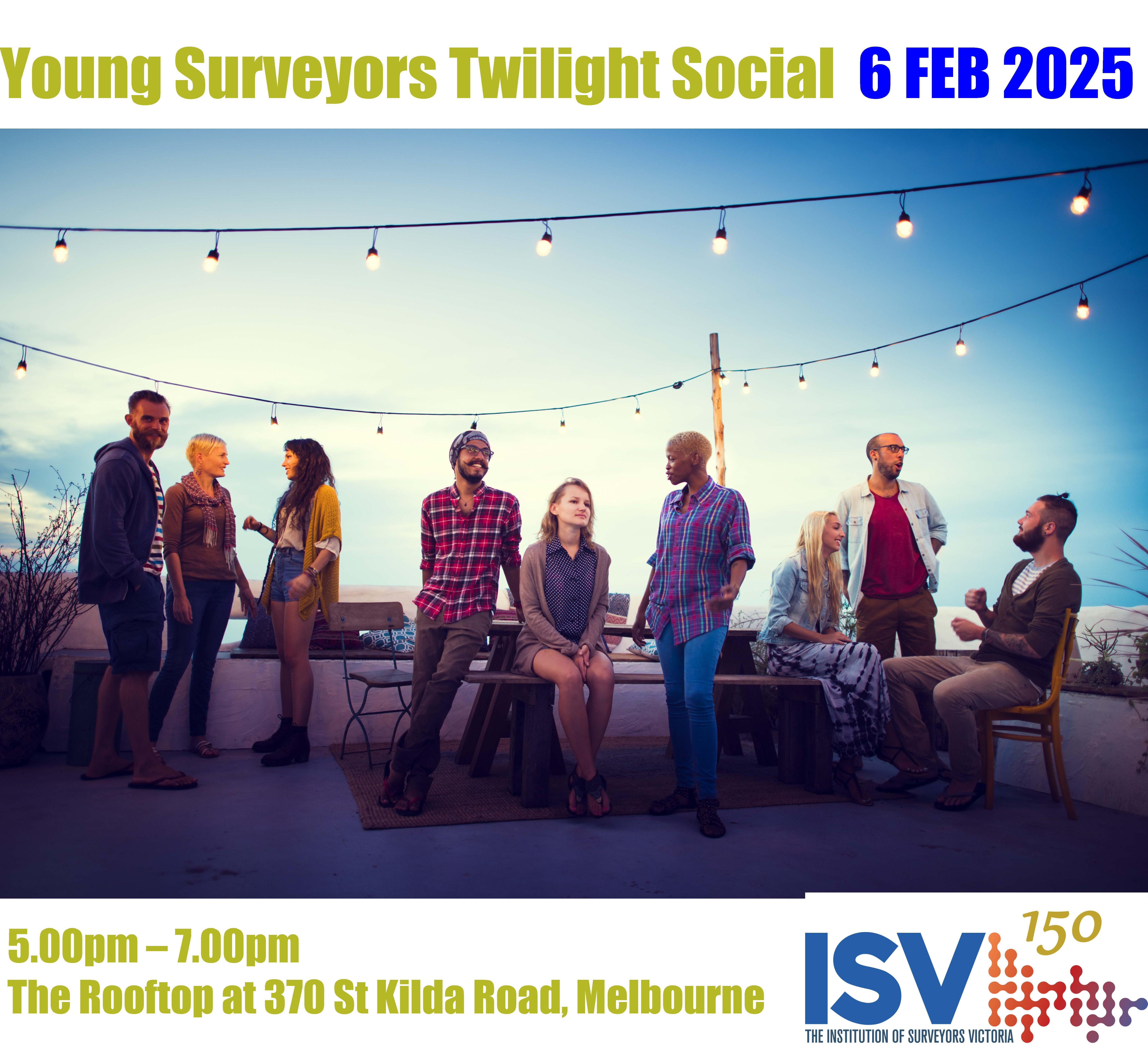
Thurs 06 ISV Young Surveyors
Twilight Social
Tue 11 ISV Heritage Rooftop
Luncheon
Fri 21 ISV Summer Seminar
02-04 Regional Conference
Wangaratta - Gateway Wangaratta Wed 07 ISV Board Meeting
Fri 23 May ISV/CSV Joint Seminar – Mooney Valley Racecourse
Mon 03 ISV Golf Day – Alphington Golf Club
Wed 06 ISV Board Meeting
Mon 10 Labour Day Public Holiday
Wed 04 ISV Board Meeting
Mon 09 King’s Birthday Public Holiday Fri 27 ISV/ISNSW Murray Group Seminar, ACT
Wed 02 ISV Board Meeting
Fri 25 ISV Survey Expo –Encore St Kilda
Wed 01 ISV Board Meeting
TBA ISV Annual General Meeting
FRI 10 Glenelg/Grampions Group Seminar & Networking
*Calendar subject to change
Wed 06 ISV Board Meeting
Wed 5 ISV Board Meeting
TBC ISV North Central Group Seminar & NetworkingBendigo
Wed 04 ISV Board Meeting
Tue 10 Colin Middleton Luncheon
Thurs 18 ISV Gippsland Group Seminar and Networking
Wed 03 ISV Board Meeting
Fri 05 ISV Christmas Seminar & Networking - TBA
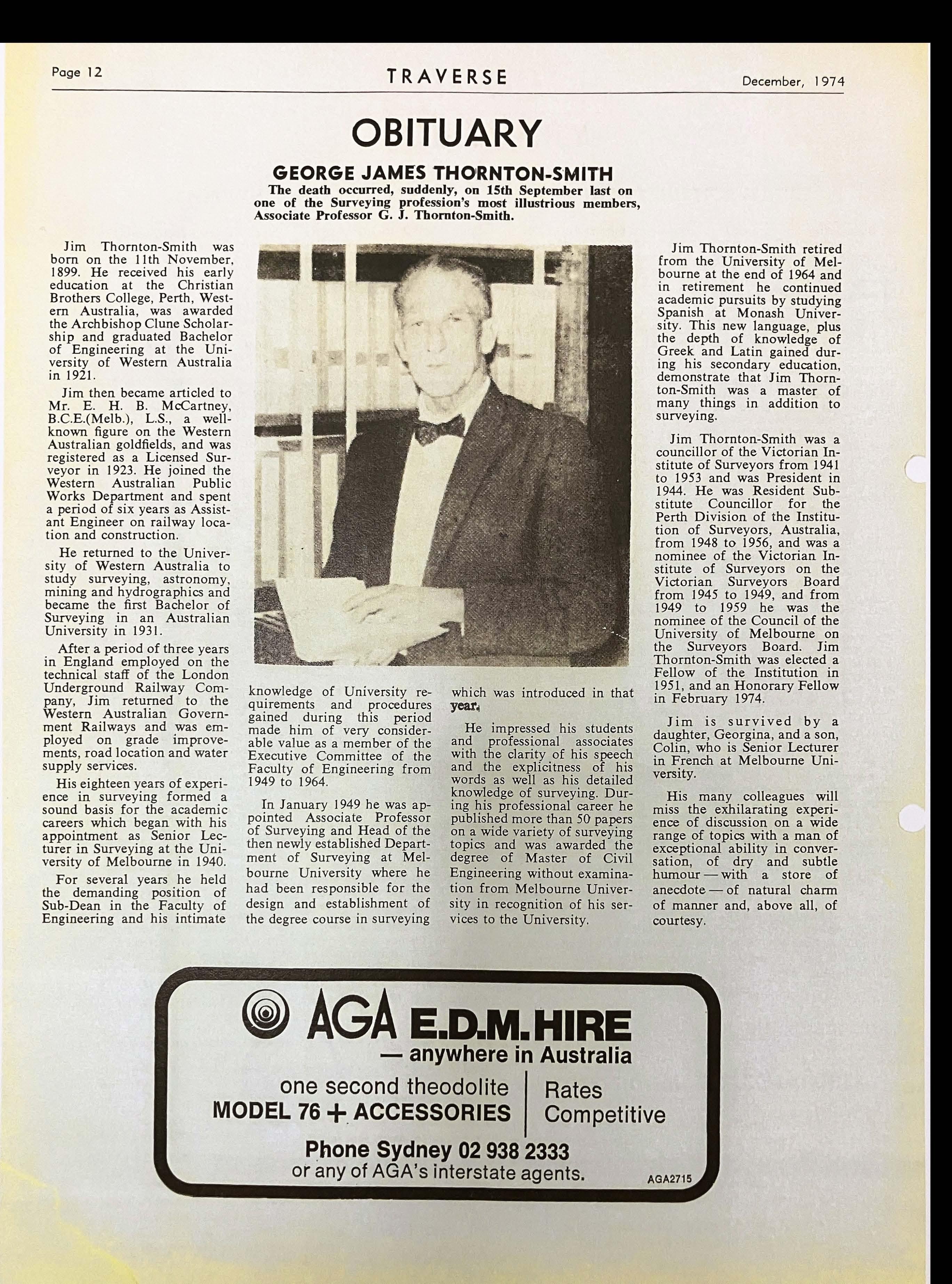
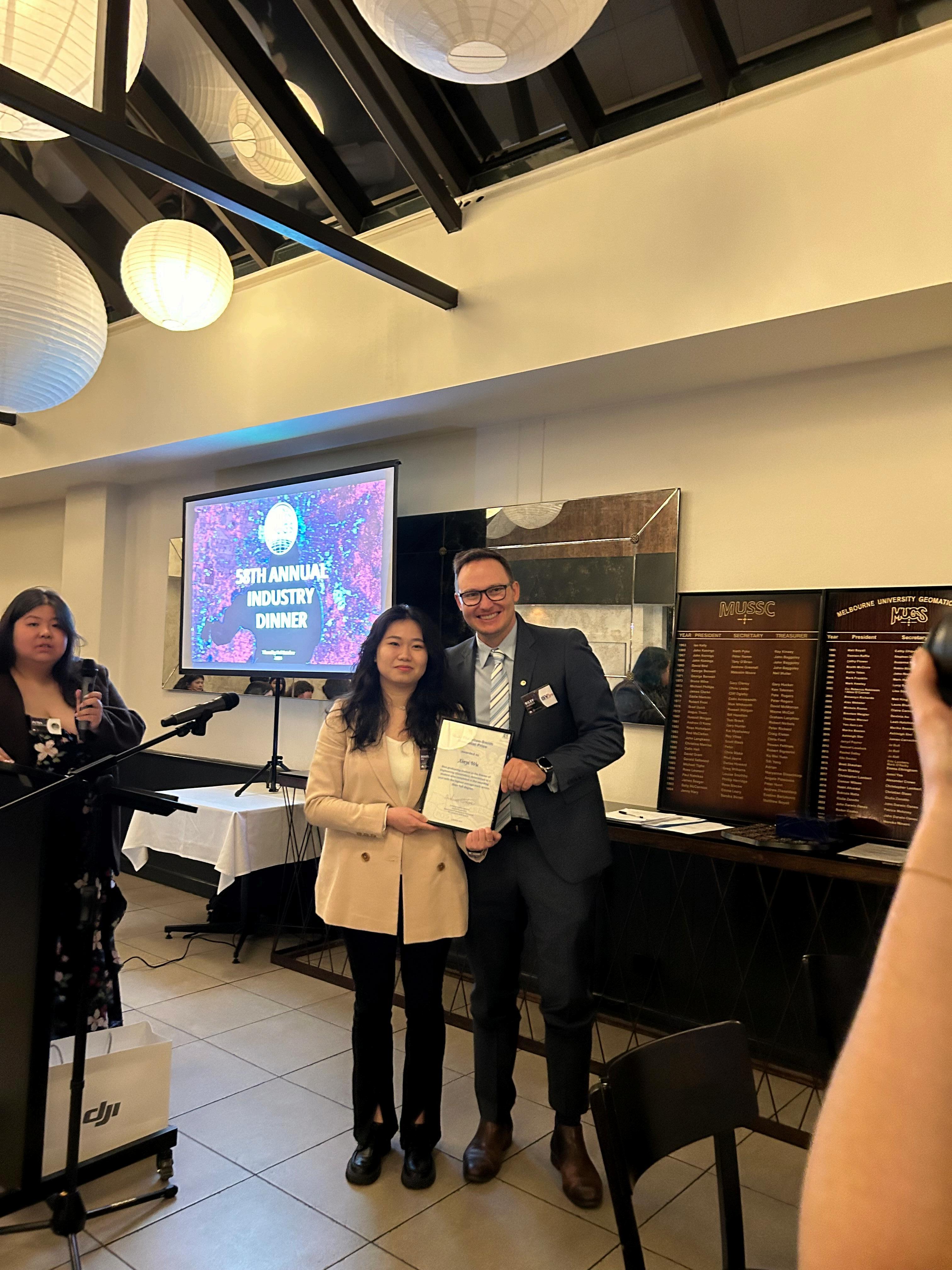
50YearFlashback! GJThornton-SmithMemorialPrize ISVDirectorRileyUlbrichawardsthesignificantGJThornton-Smith MemorialPrizetoXinyiWilaWuattheMelbourneUniversityGeomatics SocietyBall.ThisprestigiousprizeisawardedannuallybytheUniversity ofMelbourneandISVsponsorsbothaplaqueandatwelvemonth membershipsubscriptiontoISV.G.J.Thornton-SmithwasanHonorary FellowofTheInstitutionofSurveyors,AustraliaandwasPresidentof theVictorianInstituteofSurveyorsin1944.Hewasamemberofthe SurveyorsBoardofVictoriafrom1945to1959andadistinguished scholarandteacher.
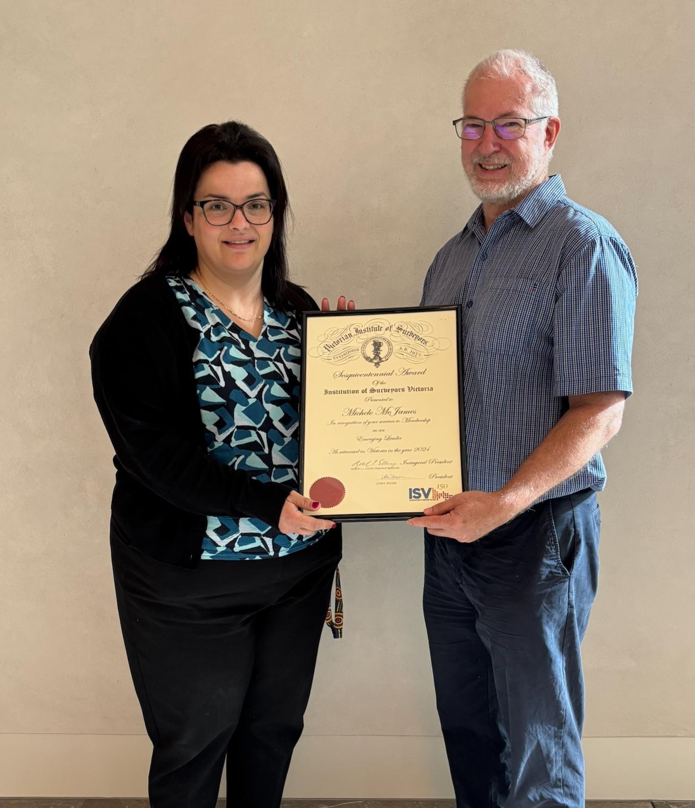
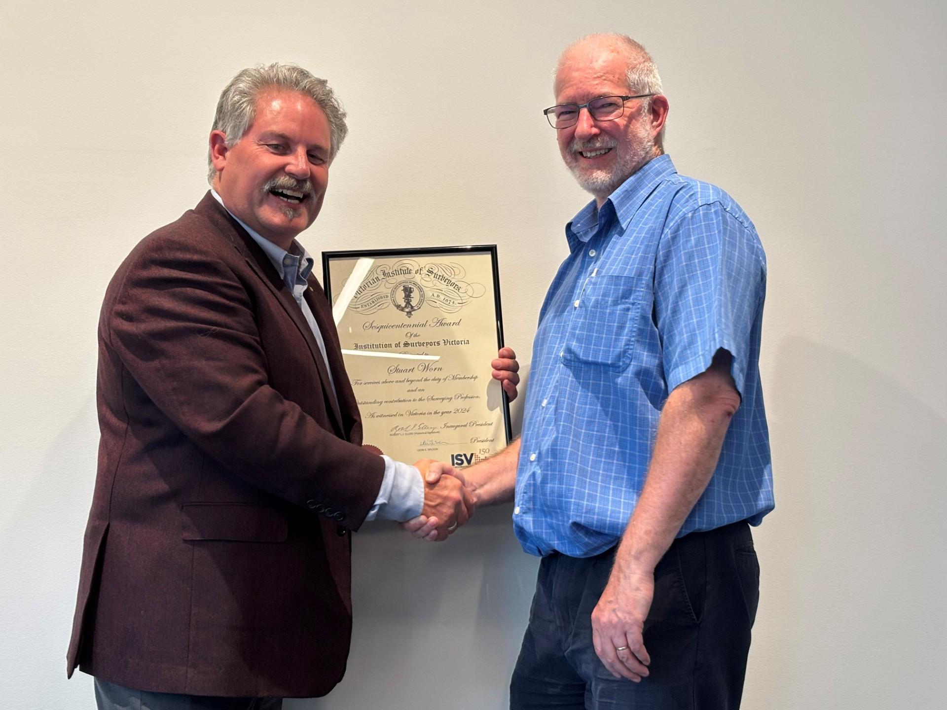
SesquicentenaryAwards SeenabovearetwofinalandmemorableimagesofPresidentofISVLeonWilsonpresentingSesquicentenary awardstotwooutstandingcontributorstothelifeofISV,Members,MicheleMcJamesandStuartWorn.
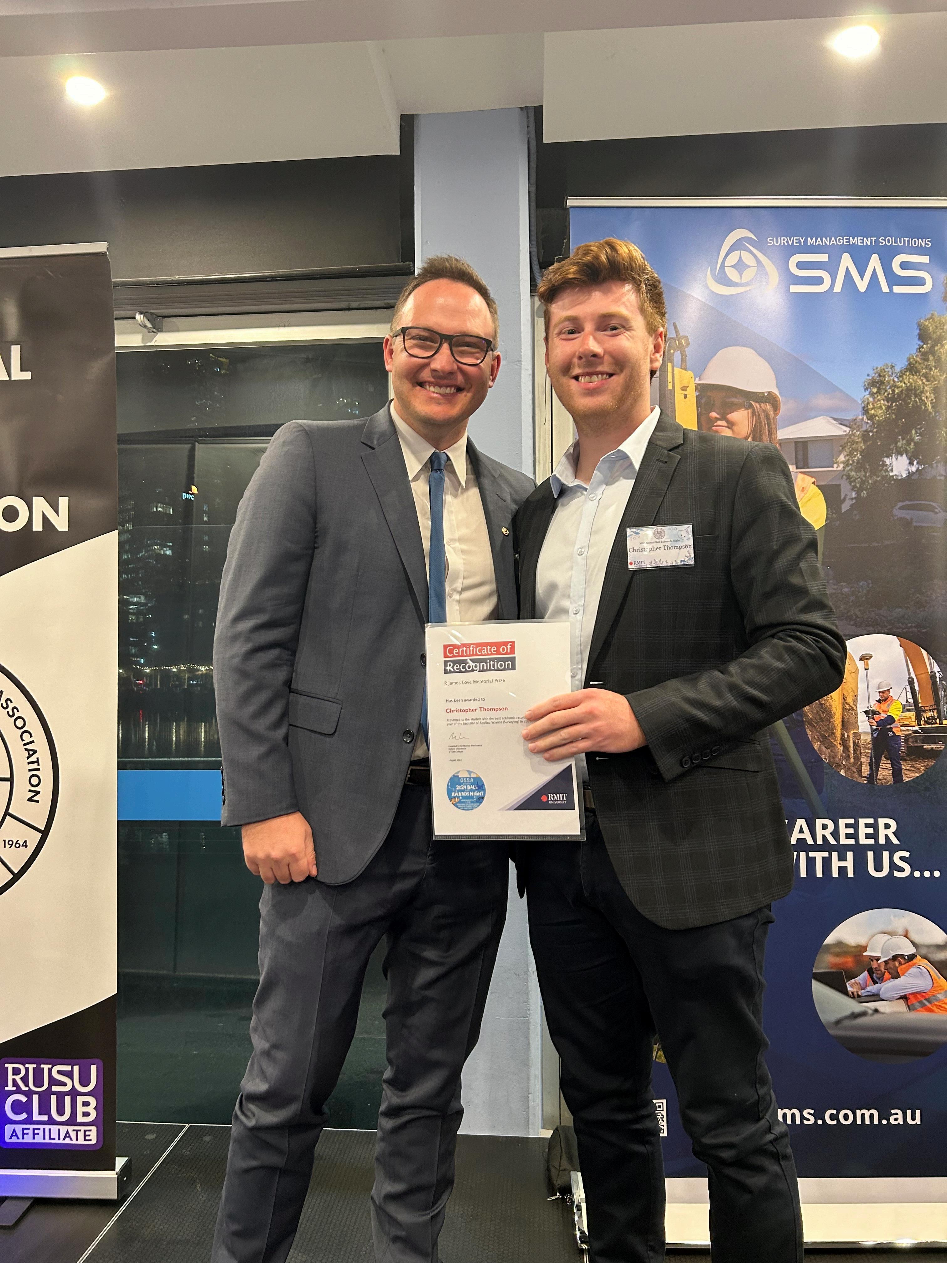
RJamesLoveMemorialPrize ISVDirectorRileyUlbrichpresentstheRJamesLoveMemorialPrizeto ChristopherThompsonattherecentRMITBall.Thishistoricprizeis awardedbyISVfortheMostOutstandingstudentinSurveyingin recognitionofbeingafinalyearSurveyingstudentwiththebest academicresultsoverthefouryearsoftheprogram.Chrisisoneto watch,alsotakinghometheWEThompsonMemorialPrize,awardedby RMITtothefinalyearSurveyingstudentwhodemonstratesoutstanding academicachievement,character,andpotentialforprofessional development,TheIanMarlerAward.awardedbyourSustainingMember ACSISLtd,forthemostoutstandingRiskManagementAnalysis submissionfortheProfessionalPracticecourse,andtheSurveyors RegistrationBoardPrizeforthestudentattainingthebestoverallresults inCadastralSurveyingandthefinalyearMajorProject (cadastralrelated).
A proposition for the Hamlet of Portsea and Port Phillip Bay To accrete or not to accrete – that is the real question - By
WebegantheyearwithSeminar150 andanexceptionalpresentationby DavidBoylebasedonthefollowing Abstract.
TheISVisprivilegedtobeabletooffer membersaccessviatheISVMember Portaltotheextensivepaperthat Davidhassincewrittenonthistopic, theresultsofyearsofworkand experience.Weareverygratefulfor Davidʼsgenerosityandtime,and publishinthehopethatsharing complextechnicalpapersoncemore becomeacentralelementofISV.
Davidhasworkedextensivelyinboth privateandpublicsectors,gaining experienceinmostaspectsofland basedsurveyingbutwithafocuson cadastralsurveyinginVictoria. He finishedhiscareerwiththeOfficeof Surveyor-GeneralVictoriain2021as theDeputySurveyor-General,arolehe occupiedforaperiodof17years. Duringthistime,Davidwasthe Departmentallicensedsurveyor representativeontheSurveyors RegistrationBoardofVictoria. DavidisaFellowoftheInstitutionof SurveyorsVictoria.
Theinformationinthefollowing articlewasoriginallypresented verballybymeattheInstitutionof SurveyorsVictoriaseminaron23 February2023. Theimages providedinPowerPointformatat thetimeofthepresentationare includedwithinthearticle.
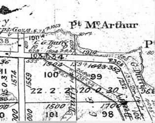
Thepresentationdiscussedthree almostidenticalapplications(1996, 2012and2022)basedonSection 103(2)oftheTransferofLandAct 1958toamendtitletotwoparcels fromLP116039(1975)atPointKing BeachinPortseainaccordancewith thedoctrineofaccretionwherethe seawardboundariesofeachparcel showedPortPhillipasanabuttal. ThelandispartofCrownallotment 96E,ParishofNepean(seeFigure1 below).
Thepresentationfocussedon Surveyor-GeneralJohnTullochʼs reportonthe2012application(as requestedbytheRegistrarofTitles) butdrawsoninformationfromthe 1996applicationandcommentson the2022application.
David Boyle Ithighlightsthethreedifferent outcomesoftheseapplicationsand thedifficultiesfacedbysurveyorsin supportingsuchapplications.
Inparticular,itdiscusses“theonus ofproof”andabilitytorelyon currentdocumentsheldbythe Registrar;theavailabilityof documentsinthepublicrecord;and, therelianceonlegalopinionover thatoftheSurveyorGeneralwhen determiningthepositionofCrown boundaries.Italsotouchesonthe rolesandresponsibilitiesofthose involvedinsuchapplications.
TheCrowngrant(1872)showedPort Philliptobeanabuttaltothelandin thegrantbutitsScheduleadvised thattheseawardboundaryofthe landwasdefinedby“theMarginof theBay”.
Itappearsthe1996applicationwas ʻrejectedʼbytheRegistrarbecause theapplicant“didnotprovide sufficientevidenceontheexpression “MarginofPortPhillipBay”-an expressionnotshowninthecurrent certificateoftitleoronLP116039.
InsupportoftheRegistrarʼs decision,theSolicitorGenerallater opinedinaMemorandumthathe was“bynomeanssatisfiedthatthis description[MarginoftheBay]is equivalenttohighwatermark”orin essence,thatthesubjectland abuttedPortPhillip.
In2012,theSurveyorGeneralwas requestedbytheRegistrar(a)to provide,ʻfromasurveyingperspectiveʼ, anopiniononthemeaningofthe phrase“MarginoftheBay”with respecttoanabuttaltoPortPhillipand (b)todiscusstheopinionprovidedby theSolicitorGeneralinhis Memorandumof1996. TheSurveyor Generalwasnotaskedtoprovide adviceonthedoctrineofaccretionor howthatmayapplytothelandinthe applications. However,assection42of theSurveyingAct2004chargesthe Surveyor-Generalwiththe responsibilityofdeterminingthe positionofCrownboundaries,a discussionofthismatterwasincluded inhisreport. Thepolicycoveringthe doctrineofaccretionstemsfromLord WilberforceinSouthernCentreof TheosophyIncvStateofSouth Australia[1982]AC706,716.
Fromasurveyingperspective, determiningthesignificanceofthe term“MarginoftheBay”wasa relativelystraightforwardtask. Itrests onthecomparisonofdimensionsof abuttingCrownallotments96Eand 100AontheParishPutawayPlan, NepeanN57(5)(seeFigure1above)and thediagramsandSchedulesofthe grantsthatresultedfromCrown subdivisionrecordedintheParishPlan. Theinformationwasconfirmedby notesandlettersfromSurveyor GeneralMr.JMReedandfrom ParliamentarySecondreading speecheswhenaneasementalongthe seawardboundaryofthelandin questionwascreatedin1910.
DiscussingtheSolicitorGeneralʼs Memorandumwasnotasstraight forwardasneithertheMemorandum noranyotherdocumentationfromthe 1996applicationwasavailablefrom thepublicrecord.
ArescindedcopyoftheMemorandum washowever,ultimatelyʻobtainedʼ fromthepersonalfilesofa Departmentalofficer. Interestingly,the SolicitorGeneraladvisedhis Memorandumwasfinalisedwhile“still waitingforadviceonsurveying matters”fromtheRegistrar.
Thislackofcriticalinformation,together withwhatseemstoreflectalimited understandingofthenatureofthe application;thesignificanceof occupationandanunpractisedor inexperiencedinterpretationofsurvey documentationsuggeststhatthe SolicitorGeneralmaynothaveheld sufficientinformationtoenablehimto advisethattherewas“insufficient evidencetosaythattheʻmarginofthe Bayʼwasequivalenttothehigh-water mark”.
TheSolicitorGeneraldidquestionwhere the“onusofproof”layindetermining thisrelationship.
Exceptfordefiningtheoriginofsome easements,theRegistrardoesnotrequire surveyorstoreturntotheoriginalCrown grantstoidentifymatterssuchas abuttalsbutpermitstheirrelianceupon thelatestregistereddocuments. Sowhy takethatapproachinthiscase? Isthere anonusontheRegistrartoaccept responsibilityforthedocumentshe/she hasregisteredandallowsurveyorstorely uponthat?
Havingascertainedthattheparcelsin questionhadanabuttaltoPortPhillip, andalthoughnotconstitutingthemajor bodyofworkfortheSurveyorGeneralin 2012,themajorissueforJohnTulloch wasthesignificantandrapidlychanging positionofthehigh-waterlevelonPoint KingBeach.
Thatis,anunequivocalacceptancethat theconditionsexistedtosatisfythe applicationofthedoctrineofaccretion suchthattheboundariesoftheparcel couldbeamendedtoaccordwiththe high-waterlevelonPointKingBeachat thedateofthesurvey. Mr.Tullochwas notconvincedthattheseconditions existedeventhoughtheDepartmentof ConservationandEnergyDoctrineof AccretionGuidelines,June1993(based onlegalʻopinionʼ)allowedforwater movementofupto7.4metresperyear, andrecommendedthattheRegistrarnot granttheapplicationbutreferittothe Court. Theapplicationwasgrantedby theRegistrarwithoutreferral. Correspondenceandcommunications aftertheprovisionoftheSurveyorGeneralʼsreportisnotavailablefromthe publicrecordbutperhapsmorecredence wasgiventolegalʻopinionʼ.
TheCourtwouldhaveprovideda definitiveoutcomesuchthatitwas notnecessarytorelyonʻopinionʼ.
Interestingly,theSurveyor-Generalʼs reportfrom2012wasnotavailable onthepublicrecordatthetimeof lodgementofthe2022application.
Infactitonlycametolightatthe timeofmakingthispresentationto theInstitutionofSurveyorsVictoria. In2022andafterthehighwatermark hadmoveagreatdealfurther seaward,theRegistraradvisedthat sheconsidereditappropriateforthe Courtstoassesstheboundariesof theparcelsinquestioninaccordance withthecommonlawdoctrineof accretionandthattheapplicationbe withdrawn.
Theeventsinthe1996and2012 applicationsseemunusual. Given thatnoinformationotherthanthe surveyorʼsplans,abstractand reportswasavailableonthepublic record,itisimpossibletoknowwhy theseapplicationswererespectively rejectedoraccepted. Whatwedo knowhoweveristhatwehavethree similarapplicationswiththree differentoutcomes. Giventhe decisionin2012nottoacceptthe Surveyor-Generalʼsadvicetorefer themattertotheCourts,coulditbe publicinterest,politics(atanylevel), orthehesitancyofthelegal professiontobescrutinisedthat playedarole?TheRegistrarʼs decisionin2022issurelythe appropriateresponsetosatisfyany oftheseʻunfoundedʼsuggestions.
Insummary,theacceptanceofthe “MarginoftheBay”ascoinciding withthehighwatermarkatPoint KingBeachleavesarealquestionat PointKingBeachof“Toaccreteor nottoaccrete”ratherthan“tobeor nottobe”asinShakespeareʼs Hamlet.
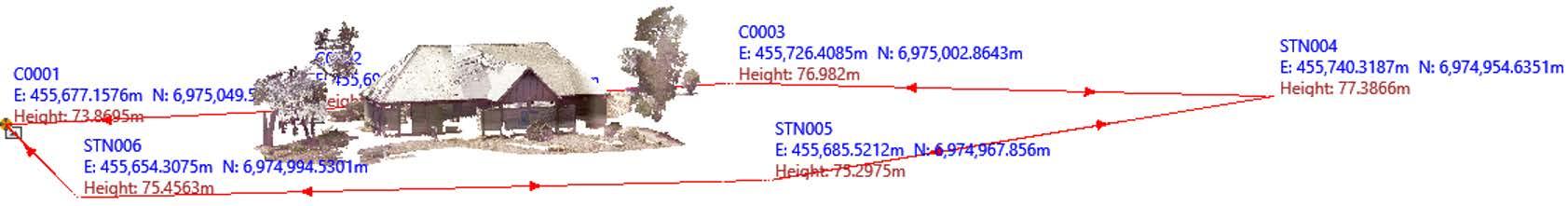
Defining the Shrine Vista Viewing Point Tom Champion - Surveying Director, Reeds Consulting Pty Ltd
TheShrineVistaisaplanning controlthatresideswithinthe Melbourne,StonningtonandPort Phillipplanningschemes.The purposeofthiscontrolisto ensurethattheShrineof Remembranceisseenagainsta clearskywithnobuiltstructure visiblewithinthespecified“Vista Zone”.
TheShrineVistaregulationswere originallyintroducedasa modificationtotheMetropolitan MelbourneBoardofWorks (MMBW)InterimDevelopment Ordinance1961.Morerecently thecontrolsweredeterminedby theMMBWShrineVista ComputationsEngineering ManualpublishedinJune1986.
In2008concernsaboutthe constructionofbuildingsinthe backgroundofthevista promptedareviewoftheexisting planningcontrolsbytheMinister ofPlanning.
In2013recommendationswere madebytheShrineTrusteesthat theShrineVistaComputations Manualshouldbeincludedinthe Melbourne,PortPhillipand StonningtonPlanningSchemes, togivethedocumentmore statutoryweight.InApril2014, theShrineofRemembranceVista Controlswereincludedasan IncorporatedDocumentinthe Melbourne,PortPhillipand StonningtonPlanningSchemes.
Propertiesinthevicinityofthevista, generallyalongSwanstonStreetandSt KildaRoad,fromtheStateLibrarytoSt. KildaJunctioncanbeaffectedbythe ShrineVistaDesignandDevelopment Overlay(DD017).Thisensuresthatthe viewoftheShrineofRemembrance downSwanstonStreetfromtheState Libraryisnotfullyorpartiallyobscured byanybuildings.Planningapplications submittedtoMelbourne,PortPhillipand Stonningtonmayrequireanassessment foritsimpactontheShrineVista.Such applicationsarereferredtotheShrine Trustees,anddependingonhowclosea proposedbuildingistotheShrine,the ShrineTrusteesmayrequirethatthe applicationbyreviewedbyaLicensed Surveyortoconfirmcompliancewiththe ShrineVistaControls.
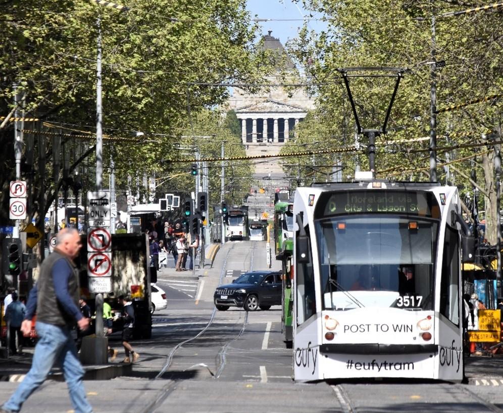
Lookingdownthe“VistaZone”totheShrineofRemembrance
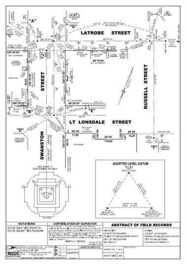
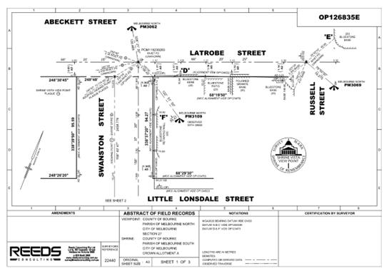
In2014ReedsConsultingwereengaged bytheDepartmentofTransport, PlanningandLocalInfrastructureto surveyanddefinetheShrineVistafor thepurposeofitspreservation.The resultingsurveywasregisteredin OP123470.
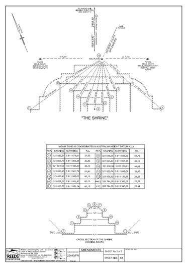
Theviewingpoint,definedbythe intersectionofthesouthernalignment ofLatrobeStreetandthecentrelineof SwanstonStreetwasmarkedwitha crossheadnail. In2024Reeds ConsultingwereengagedbyMelbourne CityCounciltoupdatethesurveythat definestheShrineVistatobringitonto GDA2020,forsubsequentinclusionin theMelbourneCityCouncilandState DigitalTwins.Theupdatesurveywas registeredinOP126835E.
DefiningtheviewingpointinOP123470
DefiningtheShrineinOP123470
Thecommissioningofanupdatedsurvey presentedauniqueopportunityto commemoratetheoccasionsofthe90th AnniversaryoftheShrineof RemembranceandtheISV Sesquicentenary,andcreatepublic awarenessabouttheShrineVistaand theimportanceofitspurposeand preservation.
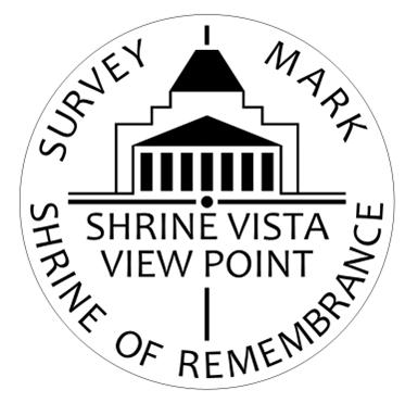
Toachievethis,MelbourneCityCouncil, Surveyor-GeneralVictoriaandtheShrine Trusteesresolvedtodesignandinstalla permanentplaqueattheviewingpoint. TheplaquewasdesignedbyAlan NormaninconsultationwiththeShrine Trustees,andplacedaspartofthe updatesurveyinJuly2024.
TheShrineofRemembranceisan iconiclandmarkandmemorial thathonourstheserviceand sacrificemadebymany Australiansacrossnumerous conflictsthroughoutourhistory.
Itishopedthattheplacementof thisplaquewillnotonlyincrease publicawarenessabouttheneed topreservetheShrineVista,but alsoprovidethepublicwitha pointofreferencetostopand enjoytheviewdownSwanston Streetandreflectonthecultural significanceoftheShrine.
Plaquedesigntemplate
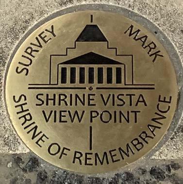
Plaqueplacedatviewingpoint
Plaque placed at viewing point by Reeds Consulting Surveyors BrettWilson(L)andArisSporidis(R)
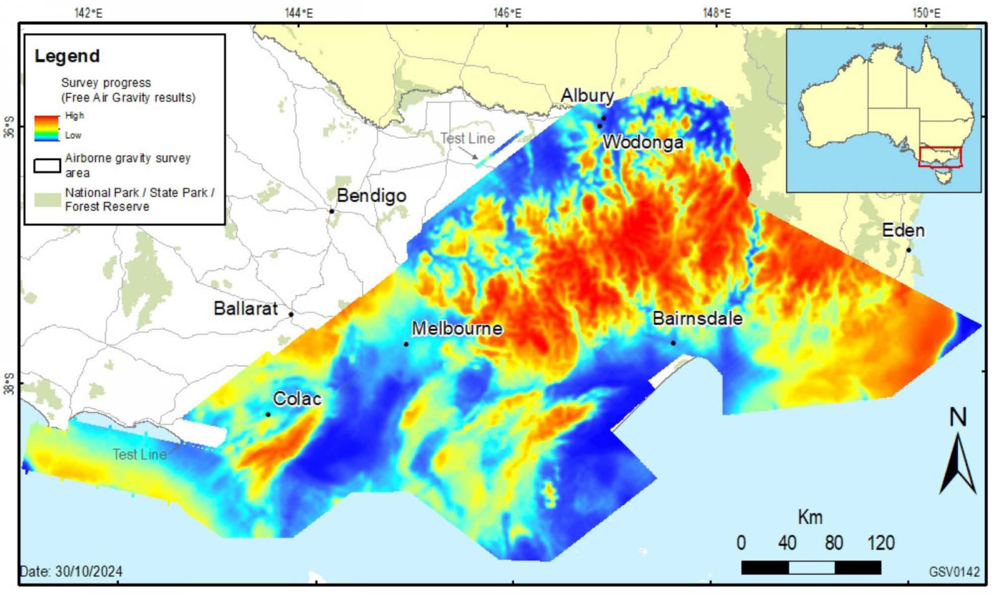
Airbornegravitysurvey NewairbornegravitysurveytoimprovetheverticalaccuracyofGPSandadvancethe understandingofVictoriaʼsgeology.
Thefollowinginformationistakenfrom therecentAirbornegravitysurvey, ProjectsandInitiatives,Surveying, DepartmentofTransportandPlanning.
Overview
Ourlarge-scaleairbornegravitysurveyto captureairbornegravitydataacross Victoriaisnowcomplete,withfinal measurementstakeninOctober2024.
BeginninginMarch2022,theaimofthe surveywastocollectconsistentand evenlydistributedgravity measurements.Thisincludeddifficult-toaccessareasthathavehistoricallyhad lessgravitydatacoveragecollected. The survey'sgravitydatawillgreatlyimprove Victoriaʼsgravitymodelandtheaccuracy ofreal-worldheightsfromGPS positioning.Thedatawillalsobeusedby geoscientiststofurtherunderstand south-eastAustraliaʼsgeological architectureandhowithasevolvedover time.
Thesurveywasdeliveredbythe DepartmentofTransportandPlanningʼs Geodesyteamincollaborationwiththe DepartmentofEnergy,Environmentand ClimateAction'sGeologicalSurveyof VictoriaandGeoscienceAustralia
GravitysurveysinVictoria
Victoriahassomeofthebestcoverage ofgroundgravitydatainAustralia,but accessingsomeareastomeasure gravityhasbeendifficult.Theseareas includethealpine,coastalanddesert regions.Becausetheyaredifficultto access,gravitydatacoverageforthese areashasbeenlimitedandthegravity modelislessreliable.
Thesurveyincluded197,217kilometres offlightlinescoveringapproximately 150,000squarekilometres.This includedtheVictoriancoastfromCape BridgewatertoCapeHowe, metropolitanMelbourne,andthe AustralianAlps.
Theresultisthelargestairbornegravity datasetevercollectedinVictoria.Itwill beintegratedwithpreviouslycaptured airbornegravitysurveysincluding coastalGippsland(2011),south-west Victoria(2019)andBendigo(2004, 2019),aswellaslandsurveygravity datasets.
Flightoperations
Theairbornegravitysurveystartedin March2022andfinishedinOctober 2024.
Specialisedgravity-sensinginstruments wereusedtomeasureextremelysmall variationsintheearthʼsnatural gravitationalpull.
Toensurehighqualitydata,aircraft wererequiredtoflyatarelativelylow altitudeandonlyinfavourableweather conditions.
Surveybenefits
Thedataandgravitymodelwillimprove theaccuracyofofreal-worldheights fromGPSpositioningtowithinafew centimetres.Thechangeswillsupport productiveandeffectiveland managementandtechnological innovationandmeetcommunity expectationsofreliableGPSpositioning inVictoria.
Thenewdatawilladvancethe geosciencethatassiststheVictorian Governmenttomanageitsearth resources,infrastructureandnatural hazards.Itwillalsoassistthestateʼs resourcessector,whichcontributesto regionaljobsandeconomicgrowth.
Dataavailability
Thegravitydatawillbefreelyavailable throughtheVictorianGovernmentʼs opendataplatformsandlicensedfor publicuse.
Thedatawillalsobeincludedinthe nationalgeosciencedatabaseanddata portalsmanagedbyGeoscience Australia.
Mapoffinalgravitysurveyresultson30October2024
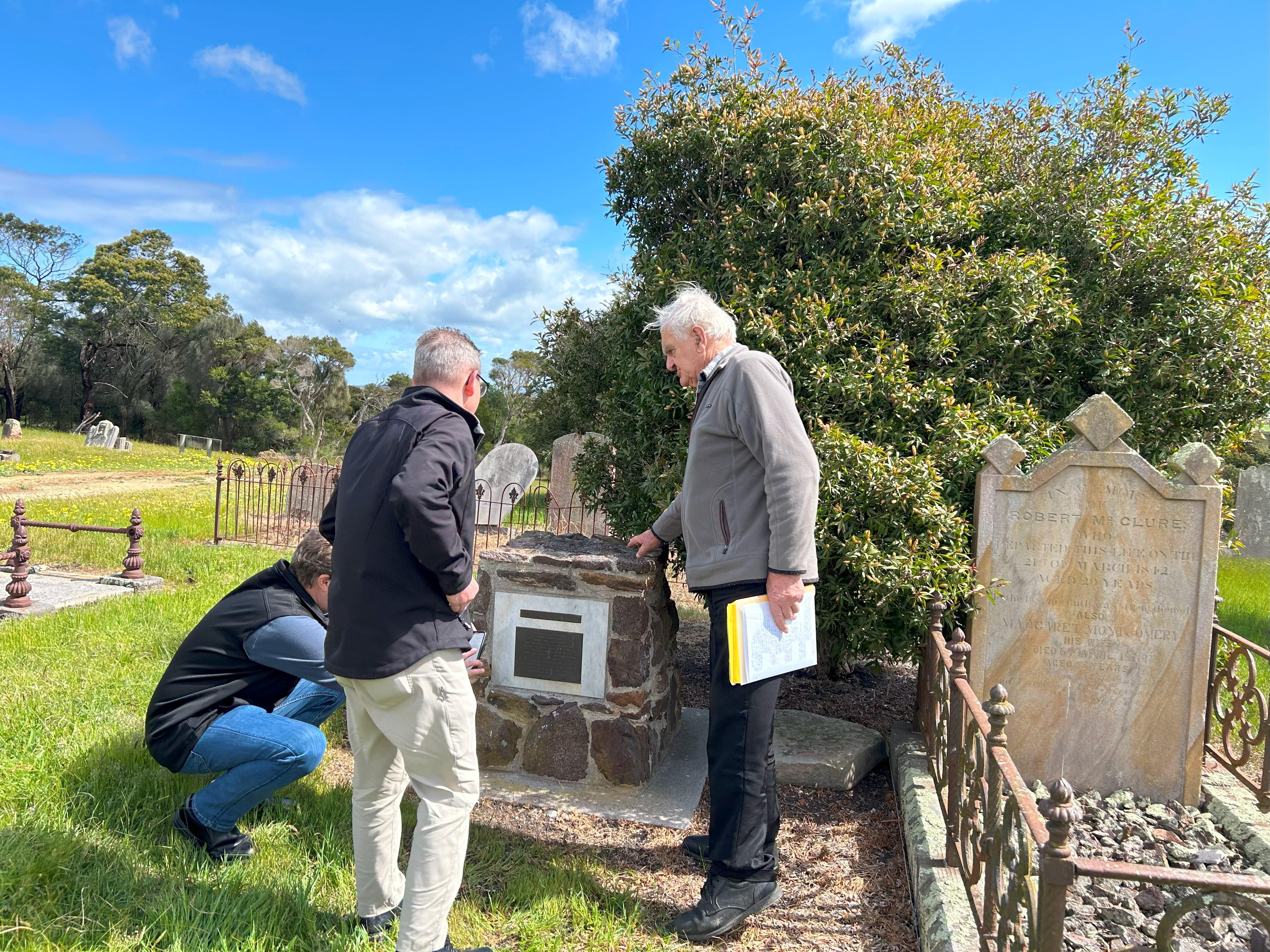
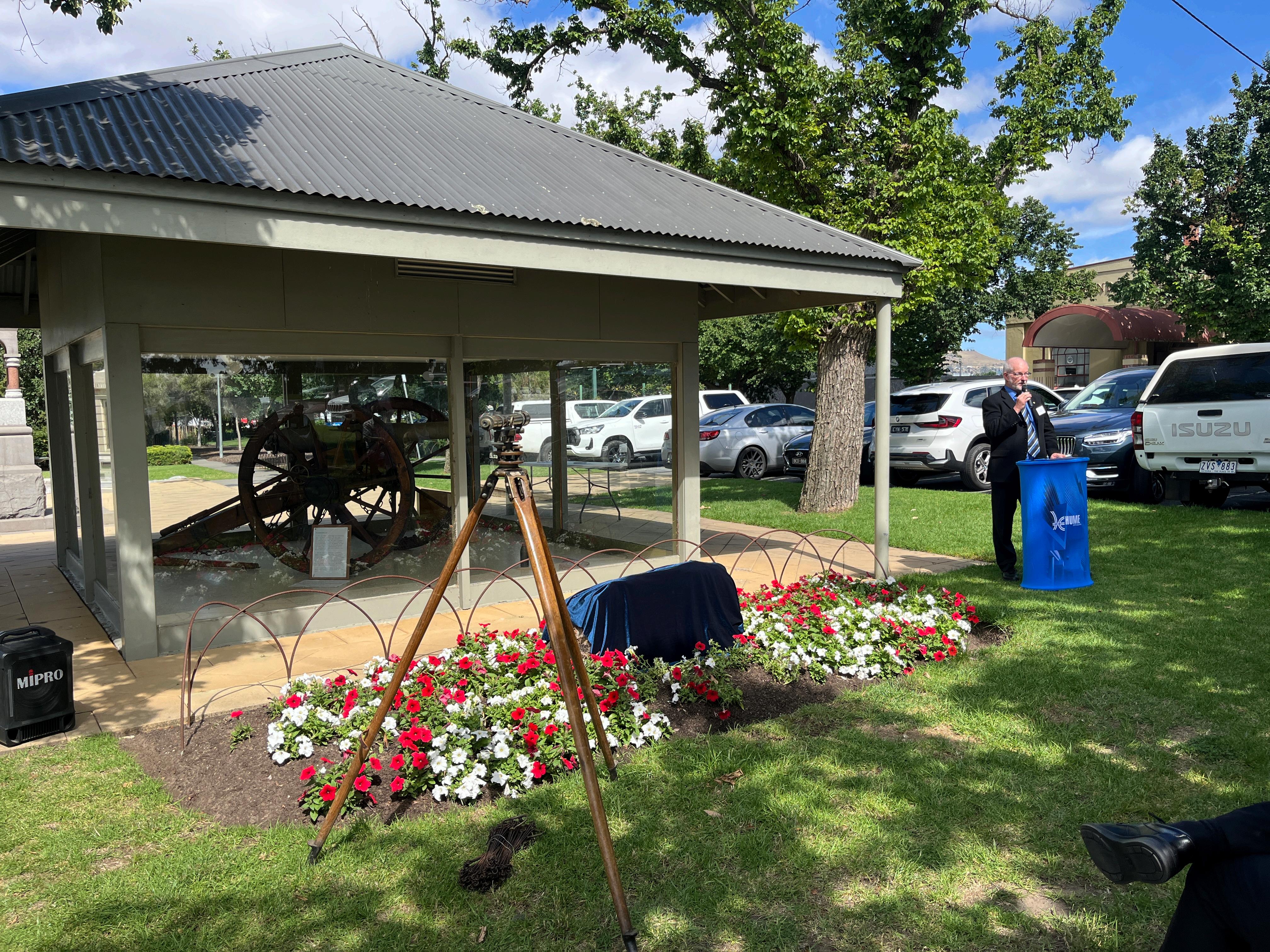
HenryWadeMemorialPlaqueunveiledinSunbury TheISValsoprovidedtheafternoontea whichfollowedthespeechesbythe dignitaries,includingISVPresidentLeon Wilson,completingwhathasbeenabusy eventscheduleacrosstheyearandacross regions.
Thenewplaqueisseeninfullonthefront coverofthisissueandhonoursthetireless workofHenryWade,notonlyinthenearby surroundsbutinestablishingtheVictoria SouthAustraliaBorderandinpartsof Queensland.
HewasPortlandDistrictSurveyorfrom1847 –1854andwasworkingonhiswaybackto Melbournewherehehadbeenoffereda moresedateGovernmentrole,butwas unabletoresistthelureofdefiningthe regionsashetravelledback.Although HenryWadehaddiedbeforeourInstitution wasestablished,heepitomisedthe professionalism,dedicationandhardwork whichinspiredthosewhofollowed.
Followingtwoyearsʼworkand muchplanning,theISVʼsfinal Sesquicentenaryeventfor2024 wastheunveilingofnewplaque honouringpioneeringsurveyor HenryWade.
WorkingcloselywiththeWade familydescendantsand Surveyor-GeneralVictoriawhoin turncoordinatedwithHumeCity Counciltolocateamost generouspositionintheVillage Greenfortheinstallation,the plaquewasunveiledbyGreat GreatGrandsonPeterWade, JoshBullMPandMayorofHume CouncilJarrodBellonTuesday 10December.
PeterWadehaswritten extensivelyabouthisancestor hadtravelleddownfrom Queenslandtotakepartandhas beenworkingcloselywiththeISV officethroughout.
TheoriginalplaquewhichISV hadhelpedfundin1997along withtheWadefamilyand VicRoadswhichwaslocatedina remotespotneartheCalder FreewayknownasTheGap,and closertowhereHenryWadehad diedwhileworkinginthefieldin 1854,hadsincebeenstolen.
ThenewplaquerecognisesISVʼs workinpursuingareplacement andhasourSesquicentenary logocentraltothedesign.
MayorofHumeCouncil,JarrodBell,HenryWadeʼsdescendantPeterWadeand JoshBullMPunveiltheplaque.
LeonWilson,PresidentofISVontheimportanceofour surveyinghistory
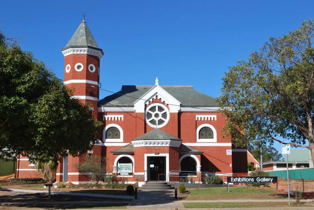
GuestsassembledbeforecrossingtotheMemorialHall fortheISVhostedmorningteawhichwasthefinal Sesquicentenaryeventoftheyear!