11 minute read
2. Natural disasters in Ecuador (1997–2008) and their effect on land access and land tenure


Ecuador
Ecuador
Advertisement
by Fausto Jordán Bucheli and Raúl Sánchez Mena*
■ 1. LAND TENURE CHARACTERISTICS AND VULNERABILITY TO NATURAL DISASTERS IN ECUADOR ■

Ecuador Ecuador
Ecuador
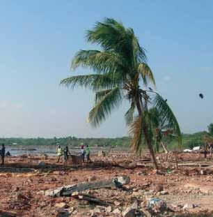
Natural disasters have increased in frequency and intensity on a global scale, and have affected a large part of the world’s population, with consequent human and economic loss, and deterioration in quality of life.
Countries in Latin America and the Caribbean have also been increasingly affected by natural phenomena such as earthquakes, volcanic eruptions, tsunamis, and hurricanes, amongst others. The El Niño phenomenon has been the principal natural cause of large-scale damage in Andean countries, producing disasters such as floods, droughts and landslides, amongst others.
CEPAL has estimated that in a typical year, these phenomena cause damage to the value of 1.500 million dollars and the loss of more than 6000 human lives, both of which result in stagnation of economic development and in the living conditions of the population of the countries where such events occur1 .
In particular, the people in developing countries that are most vulnerable when disasters occur are poor population living in rural areas or on the edge of cities, because they are settled in the areas of greatest risk and they do not benefit from the infrastructure or resources required to mitigate the effects of natural phenomena, or indeed phenomena that are man-made.
Ecuador

©FAO/E. Yeves
* Mr. Jordán Bucheli is a land tenure and land reform expert for Latin American countries and Ecuador in particular. He collaborates in the formulation of land tenure and rural development policies in Ecuador. * Mr. Sánchez Mena is an Ecuadorian land tenure and rural development specialist working as a consultant for national and international institutions such as FAO, and others. 1 CAF – The El Niño Phenomenon 1997–98: Memories, Challenges and Solutions – Ecuador.
As far as the security of land access and tenure is concerned, the negative impact of natural disasters on the poorest and most vulnerable population groups should be given form and publicised in order to create a greater conscience in governmental authorities and in the international community. The aim is that these authorities will act to improve security of access to, and tenure of, the land, given that land is an asset which facilitates production processes, sustainability, and the self-esteem of rural communities.
1.1 Ecuador, its characteristics
Continental Ecuador is in the extreme northwest of South America, bathed by the Pacific Ocean and traversed by the two principal branches of the Andes mountain range, including a series of volcanoes, some of them active. This situation – its geographical position and its geological characteristics – mean that phenomena such as earthquakes, volcanic activity and floods are all frequent.
Ecuador is bordered by Peru to the south and east, Colombia to the north, and the Pacific Ocean to the west. Geographically speaking, the country is made up of four regions: Sierra, Coast, Amazon, and the island region of the Galapagos. These cover an area 256.370 km2 with a 2007 population (according to INEC) of 13.605.485 people.
The percentage of poor amongst the national population was 36.3 % in 2006, of which 61,5% were rural poor, compared with 24,9% urban poor.
THEAGRARIANSTRUCTURE Despite more than 40 years having passed since partial agrarian reform, which occurred between 1964 and 1973, Ecuador’s principal farmland is still found in few hands2. According to figures from the III National Agricultural Census in 2001, there are 842.882 Agricultural Production Units (APUs) in an area of 12.355.831 hectares. Of the total APUs, 63.5%, or 535.309 hectares, relate to small producers plots with less than 5 hectares. This demonstrates that significant problems still exist in the distribution of productive land within the country: APUs of less than 5 hectares amount to no more than 6.3%, of the total national agricultural land area, whilst APUs larger than 50 hectares amount to 60.7% of such land area.
The agricultural reform process begun in 1964 did not improve distribution of the land, but rather maintained the concentrated structure whereby the best land was held in just a few hands. Smallholders in the Sierra where obliged to occupy the higher lands, whose low quality soils and susceptibility to erosion cause degradation of the high plateaus, misty forests and water sources3 .
The Law on Agricultural Development was promulgated in 1994 with the purpose of driving agricultural modernisation and consolidating a new concentrated structure, supported by the private sector. In this sense productive economic variables became important, whilst social, cultural and ecological ones were sidelined. A market for land was promoted as a strategy for the improvement of efficiency and the levels of production and productivity in the countryside, limiting small peasants’ access to the land. Consequently small farmers were forced to move and occupy the highlands with low fertility and high erosion soils.
According to figures from the III National Agricultural Census (MAG – SICA 2000), in Ecuador 68.4% of the APUs are titled, which corresponds to 71.9% of the total agricultural land area. Meanwhile 6.7% of the APUs, equivalent to 992.514 hectares, are worked without title to the land, without a leasing contract and therefore without paying rent, although they have complete use of the land and the APU’s activities4 .
In 2008 the newly adopted Constitution has addressed peasants’ access to land supporting the promotion of redistributive policies to favour access to land, water and other natural resources. In article 282, the Constitution establishes by law a national land fund that will allow equal access to land to female and male peasants, and forbids land concentration and water privatisation.
VULNERABILITYINTHEFACEOFNATURALDISASTERS Ecuador is a country highly-vulnerable to destructive natural phenomena, situated as it is in the “Pacific Ring of Fire”, and in the subduction zone of the Nazca Plate under the South American Plate. Similarly, geological fault lines separate the country’s geological regions, making Ecuador highly vulnerable as a
2 FEPP – International Land Coalition – IFAD 2005 – The cost of the land – could funds for land acquisition be useful to the poor? For peasants, land is not only an essential mean of production, but also the basis and meaning of social life, given that family and community are integrated here, and identities are constructed symbolically, via direct work on the plot and the cultural assimilation of territory. 3 SENPLADES National Development Plan 2007–2010. 4 MAG–SICA 2003, Agricultural Producers and their Environment.
potential scenario for earthquakes and volcanic activity; this affects the country’s potential for development since it is at high risk of natural disasters.
As a consequence of climate change and environmental degradation, Ecuador has experienced sustained increases in temperature, changes in the frequency and intensity of extreme events (droughts, floods, frosts), changes to the water cycle, and the retreat of glaciers.
Various geographical characteristics of the country – such as the presence of the western, central and eastern cordilleras of the Andes mountain system, and the highly-variable climate – contribute to floods, heavy seas, lack of rain, and landslides.
The pattern of natural disasters in Ecuador is characterised by a steady increase in the number of events and also their impact, principally those associated with floods, droughts and extreme temperatures. According to the worldwide EM-DAT (2007) database, between 1990 and 2006 there were a total of 29 largescale natural disasters, 59% of which were of climactic origin. Although there has been a progressive decrease in the number of deaths caused by such disasters, there still exists a significant increase in the number of victims, mainly amongst the poor.
In recent years Ecuador has experienced a variety of natural phenomena of significant magnitude and extension, resulting in certain catastrophic events causing grave socioeconomic and environmental imbalances, and adversely affecting the development of the nation and the national economy. 1.2 Land tenure legislation and risk management
LANDTENURE The Law on Agricultural Development, promulgated in 1994, establishes a policy to foment, develop and protect the agricultural sector, guaranteeing individual and collective land tenure security. In a special way it also facilitates the right of access to land titling.
Similarly, and in accordance with the laws established in articles 282 and 321 of the 2008 Republic’s Political Constitution, the State should rule the equal access to land to female and male peasants and guarantee land ownership. This establishes that work on and use of the land can be carried out individually, in cooperatives, in associations, communally, or within a family or limited company, so long as its social and environmental purpose is achieved.
According to the law, the land meets its social function when it is exploited productively, when its renewable natural resources are adequately preserved, when the ecosystem is protected, when all Ecuadorians’ nutritional needs are guaranteed, and when surpluses are available for export. The land’s social function should translate into an increase and redistribution of income, so that the whole population shares the benefits of development and the profit that comes from this.
Land policy in Ecuador is the responsibility of a complex institutional framework within two branches of the State: the executive (MAGAP–INDA, MAE,

©FAO/F. Botts
MIDUVI) and the judicial (Notaries and the Property Register). This fragmentation means that no single entity assumes the leadership role in the formulation and application of land policies that support sustainable development processes.
Responsibility for land administration is the ambit of the Ministry of Agriculture, Livestock, Aquaculture and Fishing (MAGAP), via the National Institute for Agrarian Development (INDA), which is responsible for land legalisation processes and the maintenance of the rural land cadastre.
RISKMANAGEMENT Until 2008, the responsibility to prevent, reduce and overcome the effects of catastrophes of whatever origin was exercised by the National Civil Defense Body via the Civil Defence System. These were combined public and private sector bodies that, through coordinated integration, executed actions designed to protect the population and its property, from the effects of disasters derived either from a natural phenomenon or from human activity. The approach of this system was mainly of a reactive type after the disaster had occurred, dealing with the aftermath effects through reconstruction and rehabilitation programmes and without an integrated approach to risk management, this approach was delegated on an ad-hoc basis to organisations created for that purpose like CORPECUADOR, COPEFEN and CPOE dealing with El Niño phenomenon (1997-1998) and the Josefina landslide (1993).
Since 2008 important advances in Risk Management have been made at the sectoral level with the incorporation of risk management variables in judicial regulations, such as the Law on Environmental Management, the Law on Forests and Conservation of Protected Areas, the Public Health System Organic Law, and similarly in the National Planning System as managed by SENPLADES. Moreover, as opposed to a reactive approach to natural disasters impacts, the 2008 new national Constitution has included in its Chapter VIII the concepts of prevention and mitigation for natural disasters risk management, as well as the need to deal with the management of risks on a decentralised and local basis. The Constitution states explicitly the need to establish a national system for the prevention and management of natural disasters.
In agreement with this approach to address risk management, and as a result of initiatives that had taken place at regional level within the whole Andean Community, in which Ecuador actively participated5, in May 2008 the Ecuadorian government via Executive Decree reorganised the Civil Defence responsibilities towards risk management so as to be part of The Risk Management Technical Secretariat attached to the Ministry for the Coordination of Internal and External Security. Presently the Secretariat is working to include an integrated approach to the management of risks in a cross-sectoral and decentralised manner, through the development of a national policy for disaster risk management, as well as other tools that will reinforce the disaster management work in the country. In particular the policy will support and strengthened an integrated approach to disaster risk management considering development as the framework of DRM for the reduction of peoples’ vulnerability against disasters. The policy will foster the participation of all public and private sectors within a decentralised manner with the involvement of national, regional and local level institutions and organisations.
In this framework the aim of this Ecuador country study is to extract lessons from the way the impact of natural disasters was managed in selected experiences before 2008, especially with regards to land tenure issues. The authors wish these lessons can be of use for raising awareness both in Ecuador and other countries, on the importance to consider land tenure access and security as key factors in the reduction of household and country vulnerability against the impacts of natural disasters.
■ 2. NATURAL DISASTERS IN ECUADOR (1997–2008) AND THEIR EFFECT ON LAND ACCESS AND LAND TENURE ■
In the last 15 years, Ecuador has suffered a variety of natural disasters of different magnitudes and intensity, which have affected the most vulnerable parts of the population to varying degrees; this population is generally found in rural areas and does not have sufficient resources to deal with the effects of natural phenomena.
The main natural disasters in Ecuador over the last 15 years, and their social and economic effects, are described in the table 1.