11 minute read
Abbreviations and Acronyms


Other programmes – such as CARE’s Shouhardo and the EU-funded HISAL (Haor Initiative for Sustainable Alternative Livelihood) programme by Concern Worldwide – work closely with UDMCs in a number of ways. For example, they help to strengthen their capacity and help them in realising several flood protection measures, such as replanting indigenous trees along community banks (to reduce wave erosion), and introducing early-maturing rice varieties which can be harvested before flash floods are likely to occur.
However, post-disaster rehabilitation and adequate support for livelihoods, including land tenure, are areas which require more attention from policy makers. Coordination among government bodies and local level institutions is required, as highlighted by the Sidr case below. During early recovery stages, agencies in charge of resettlement planning and programmes must consider for example that the resettlement areas identified are not located in hazardous zones, and ensure that the lease deeds for landownership are clear and registered to ensure tenure security for the resettled households. The beneficiary households should also be clearly identified and belong to the most affected and needy category of households. Too often, resettlement programmes are rushed and not implemented with sufficient care, causing problems during their implementation and also in the long term: people are again affected by natural disasters because they have been resettled in marginal, disaster-prone areas, or registration of land title deeds is disputed, leading to violence over land and disputes over land settlements.
Advertisement
3.7 Case Study: Sidr cyclone
The southern districts of Bangladesh were severely hit by the powerful Sidr cyclone on 15th November, 2007. More than nine million people were affected, and the death toll was around 4000. It is estimated that more than 563 000 houses and 2240 schools and colleges were destroyed; 955 000 houses and 11 490 educational buildings were partially damaged within the affected districts. After cyclone Sidr’s landfall, the government, armed forces, local civil organizations and volunteers, all moved quickly to mount search-andrescue operations and to distribute food, water, clothing and other emergency items to cyclone survivors. The reduced death toll compared with previous cyclones42 is a testament to improved community preparedness measures and a huge credit to the 43 000 volunteers working under the government-funded ‘Cyclone Preparedness Programme’.
SIDRANDLANDTENUREISSUES A reconnaissance survey on landlessness in the six Sidrhit areas was conducted by UN-Habitat to gather indepth information on shelter conditions of the affected households. The survey results showed that 31 percent had no homestead land whatsoever, and about 66 percent had homestead land with land rights certificates that proved ownership (see Table 6).
TABLE 6 – Land tenure status of Sidr affected households
LAND TENURE OF RESPONDENTS FREQUENCY PERCENT
Have a land rights certificate 115 63.19 Had a land rights certificate but have lost it 6 3.30 Never had a land rights certificate but occupy land 4 2.20 Don’t have any land on which a house can be built 57 31.31 Total 182 100.0
Source: Socio-economic survey of Sidr hit households, UN-Habitat, Dec 2007.
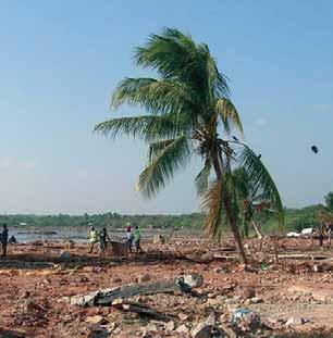
FIGURE 1 – Flood 2007 and cyclone Sidr affected area

©FAO/G. Napolitano
It was found that a significant proportion of the affected households, and one of the most vulnerable groups were landless people, both pre- and postcyclone. When the Sidr cyclone hit, they were living on the outside of the embankments. They experienced the highest degree of losses to their homes and assets; most of these families continued to live off what remained of the land outside of the river embankment, without any legal land rights certificates. As a result, they are likely to be overlooked or neglected in terms of housing assistance, and displaced if no measures for rehabilitation are taken. Several NGOs including Oxfam International called for the government to take a pro-active approach to support landless people, both in terms of addressing their short- to medium-term shelter and livelihood needs, as well as accelerating existing land policy reforms and government-run resettlement programmes. There has been a strong call by CSOs and NGOs to establish a clear timeframe for khas land resettlement programmes and for addressing current policy loopholes, which favour rich landowners over landless people in the re-allocation of land43 .
POST SIDR GOVERNMENT PROGRAMME A recent circular from the MoFDM describes the annual development plan allocation, for 2008–2009, as regards construction of flood shelters in flood prone and river erosion prone areas44. About 1000 baracks are to be built for 10 000 Sidr-affected families in eight coastal districts, at an estimated cost of US$ 15 million. Around 74 multi-functional flood shelters will be constructed in the flood prone and river erosion prone areas to provide shelter during disasters. In normal times, these shelters will serve as educational buildings. Critics suggest that these programmes are not well thought through, and merely serve the interests of the programme-implementing agencies and contractors, rather than the affected people. Similar barracks have been built in previous Asrayan and Grihayan projects, and proved not to be sustainable. Often, existing cyclone shelters are not user-friendly, and sometimes do not cater for the specific needs of women and children. It is feared that the proposed flood shelters will show similar design and construction flaws and will for the most part be underutilized. Also, certain issues are not reflected in the proposed government-led Sidr rehabilitation programme, such

©FAO/G. Napolitano
as land tenure conditions, supporting and building up livelihood strategies, and the participation of people during rehabilitation, planning and implementation.
However, an encouraging development is that the Ministry of Land has been granted a donation by the Japanese government for Sidr-affected landless people, to help with their rehabilitation and to guarantee their land tenure rights. The Adarsha Gram project will serve about 40 000 people in 12 districts, covering about 122 resettlement sites located on khas land areas already identified and earmarked for resettlement programmes, even before the Sidr cyclone occurred 45 .
3.8 The Bhumi Bank: a way to address land tenure issues in disaster prone areas?
The concept of a Land Bank, such as exists in the Philippines, and whose aim is to target the allocation and redistribution of khas land to landless people in disaster-prone areas, may also work in Bangladesh. The Land Bank is the fourth largest bank in the Philippines in terms of assets and loans, and is also the largest government-owned bank; it mainly provides services in rural areas. The Bank was established in 1963 as part of the national land reform programme. It acts as an intermediary by purchasing land from large agricultural estates and selling this to small landholders and the landless46. The major characteristics of the Land Bank are: •It is a government financial institution that strikes a balance between fulfilling its social mandate of promoting rural development, and remaining financially viable. •The Land Bank has successfully managed this balancing act, as evidenced by the continued expansion of its loan portfolio in favour of its priority sectors: farmers and fisher folk; small, medium and micro enterprises; livelihood loans and agribusiness; agro-infrastructure and other employment-related projects.
•The Land Bank is by far the largest formal credit institution in rural areas of the Philippines. Its credit delivery system is able to penetrate a substantial percentage of the country’s total number of municipalities.
Moving on from its initial role as the financing arm of agrarian reform, the Land Bank has evolved into a full service commercial bank. But the essence of its existence has not changed, and it continues to play an important role in the rural economy.
The Philipinnes’ Land Bank could serve as a model for a similar public bank in Bangladesh, called the Bhumi Bank, bhumimeaning ‘land’. The Bhumi Bank might play the following roles: •Be involved in land valuation, compensation to owners of private agricultural lands, and the distribution of land among landless and migrant farmers; •Provide credit services to landless and migrant farmers so that they can purchase land; •Provide access to credit for both small traders and marginal farmers, for demand-driven entrepreneurship; •Cater to the special needs of disadvantaged groups such as female-headed households, various tribal groups and the disadvantaged elderly; •Serve a vital role in promoting rural development, covering both farm and non-farm enterprises, with the aim of enhancing rural livelihoods.
In the long term, the Bhumi Bank could play a role in regulating the value of land in local growth centres (i.e. district and Upazila/union centres). It might also be involved with conserving farmland and common property resources, or open spaces such as grazing land (as in the charareas), or forests and water bodies. The Bhumi Bank would act as a public authority to hold, manage and develop all land-based properties as noted above. It would play a role in ensuring more effective and equitable property acquisition and disposition (including sikostiand poistilands, see also section 2.6). The Bhumi Bank would keep and maintain records on khas land, including landholding patterns, patterns of land use, land distribution and information on common property resources. In addition, the Bhumi Bank would perform any other normal banking operations and transactions as carried out by other commercial banks. It could offer various insurance schemes with soft premiums in order to safeguard crops, livestock and homesteads against any natural and man-made calamities. For the Bhumi Bank to be effective, extensive research and strategic planning at all institutional levels would be required, as well as genuine commitment on the part of both central and local governments. Following the example of the Land Bank, the Bhumi Bank could also play an important role in addressing some of the current land tenure inequalities, and strengthen the resilience of people living in disaster-prone areas of Bangladesh.
3.9 Some conclusions
In summary, the poor in Bangladesh, and especially the landless poor, are disproportionately affected by natural disasters. They primarily depend on climatesensitive sectors such as agriculture and fisheries, have limited scope to respond to and cope with the impact of disasters, and tend to live in more exposed and marginal areas such as the chars, flood plains, and along river and coastal banks. Landownership patterns in Bangladesh are highly skewed, with 10 percent of the population owning almost 50 percent of the agricultural land. This rich 10 percent often comprises absentee landowners living in urban areas who rent/lease their land on cash or sharecropping terms. Many of the rural poor do not own any land and lack opportunities to find agricultural wage labour; as a result, some are trapped into insecure and unfavourable sharecropping arrangements. Others migrate to newlyformed char settlements in high risk areas, their only viable alternative. In the absence of more effective and more equitable land tenure arrangements, the poor and landless will remain extremely vulnerable to disasters and the impact of climate change.
There are several land redistribution programmes in place, but their progress and positive effects are the subject of debate. The absence of an up-to-date, systematic and universally accepted source of information on land resource availability and land rights is one of the key barriers to the successful implementation of land reform programmes, and the effective handling of land disputes. Availability of khasland is limited and also concentrated in a few areas. There is a need to consider regional variations when designing implementation strategies, to ensure that land reform programmes are effective. In addition to genuine political commitment, a reform of the land administration to streamline current systems and organizational structures will make land reform programmes more transparent, efficient and effective.programmes more transparent, efficient and effective.
Some legal provisions are made to deal with specific land tenure issues reflecting disaster-prone conditions, such as the Sikosti-PoistiAct. In practice, this Act is not a success, because of the ineffectiveness

©FAO/G. Napolitano
of the current land administration and the inherent high transaction costs for the poor and landless: in terms of time, money and limited access to information and support services.
Current disaster management programmes do not pay sufficient attention to the importance of land tenure issues, which are a key factor increasing poor people’s vulnerability to disasters. Similarly, post-disaster rehabilitation programmes are ineffective at supporting landless and affected households in rebuilding their livelihoods. The relationship between land tenure issues and disasters is not reflected and integrated in several key policy frameworks, such as the Poverty Reduction Strategy Paper, the National Plan on Disaster Management 2008–2015, and the Standing Order on Disasters. In practice, there needs to be a stronger link between land distribution and resettlement programmes, and disaster preparedness and rehabilitation programmes. Current initiatives on community-based disaster preparedness are a positive step in the right direction. Involving communities in the mapping of disaster-prone areas, in assessing the major forms of land use and the quality of specific land areas, and in listing vulnerable groups (e.g. landless households, women-headed households and minority groups), will improve disaster preparedness and disaster response programmes by making them more location specific and more effective at the implementation stage, because they will be based on local institutions and knowledge systems. Experiences from the Bhoomi project in the Indian State of Karnataka – where digitalized land records are increasing access to and transparency of information – could prove a viable method of making Bangladeshi rural households less vulnerable to land disputes when title deeds and documentation is lost to natural disasters.