16 minute read
2. Land tenure in Bangladesh


Abbreviations and Acronyms
AIM Mozambican Information Agency (Agencia de Informação de Moçambique) CBNRM Community- Based Natural Resource Management CCD District Consultative Councils (Conselhos Consultivos Distritais) CCGC Coordinating Council for Disaster Management (Conselho Coordenador de Gestão de Calamidades) CCM Christian Council of Mozambique (Conselho Cristão de Moçambique) CDL Local Development Commissions (Comissões de Desenvolvimento Local) CDS Centre for Sustainable Development (Centro de Desenvolvimento Sustentável) CENACARTA National Centre of Mapping and Tele-Detection (Centro Nacional de Cartografia e Tele–Detecção) CFJJ Legal and Judicial Training Centre (Centro de Formação Jurídica e Judiciário) CTGC Disaster Management Technical Council DCU Directorate of Construction and Urbanisation (Direcção de Construção e Urbanização) DEC Disasters Emergency Committee DfID Department for International Development DINAGECA National Directorate of Geography and Cadastre (Direcção Nacional de Geografia e Cadastro) DINAT National Directorate of Land (Direcção Nacional de Terras) DNFFB National Directorate for Forestry and Wildlife (Direcção Nacional de Florestas e Fauna Bravia) DNPOT National Directorate of Territorial Planning (Direcção Nacional de Planeamento e Ordenamento Territorial) DNTF National Directorate of Land and Forestry (Direcção Nacional de Terras e Florestas) DPADR Provincial Directorate of Agriculture and Rural Development (Direcção Provincial de Agricultura e Desenvolvimento Rural) DPCCN Department of Natural Disaster Prevention and Relief (Departamento de Prevenção de Calamidades Naturais) DTA Department of Land and Water (Departamento de Terras e Aguas) DUAT Right of Use and Benefit (Direito de Uso e Aproveitamento) FAO Food and Agriculture Organization of the United Nations FRELIMO Mozambican Liberation Front (Frente de Libertação de Moçambique) G9 Group of Nine GDP Gross Domestic Product GoM Government of Mozambique ICT Community Land Initiative (Iniciativa de Terras Comunitárias) IFRC International Federation of Red Cross and Red Crescent Societies IIAM Mozambican Institute for Agronomic Research (Instituto de Investigação Agraria de Moçambique) ILO International Labour Organization INE National Statistics Institute (Instituto Nacional de Estatística) INGC National Institute for Disaster Management (Instituto Nacional de Gestão de Calamidades INGO International Non-Governmental Organization INIA National Institute of Agronomic Investigation (Instituto Nacional de Investigação Agraria) INPF National Institute of Physical Planning (Instituto Nacional de Planeamento Físico) IUCN International Union for the Conservation of Nature LAHS Land Application Handling System LIMS Land Information Management System LINK Mozambican Coordination Body of Civil Society Groups MADER Ministry of Agriculture and Rural Development (Ministério de Agricultura e Desenvolvimento Rural)
Advertisement
MAE Ministry of State Administration (Ministério de Administração Estatal) MCC Millennium Challenge Corporation MICOA Ministry for Environmental Coordination (Ministério de Coordenação Ambiental) MoA Ministry of Agriculture (Ministério de Agricultura) MPD Ministry of Planning and Development (Ministério de Planificação e Desenvolvimento) MPF Ministry of Planning and Finance (Ministério de Planificação e Finanças) MSF Médecine Sem Frontières MTEF Medium Term Expenditure Framework NGOs Non-Government Organizations NLC National Land Commission OCHA United Nations Office for the Coordination of Humanitarian Affairs ORAM Rural Association for Rural Mutual Assistance (Associação Rural de Ajuda Mutua) PARPA Action Plan for the Reduction of Absolute Poverty PES Economic and Social Plan (Plano Económico e Social) PRA Participatory Rural Appraisal PROAGRI Mozambique’s Sectoral Reform Programme in Agriculture PTIP Three-Year Public Investment Plan RENAMO Mozambican National Resistance (Resistência Nacional de Moçambique) SARCOF Southern African Regional Climate Outlook Forum SCF–UK Save the Children UK SEA Strategic Environmental Assessment SETSAN Technical Secretariat for Food Security and Nutrition (Secretariado Técnico de Segurança Alimentar e Nutricional) SIDA Swedish International Development Cooperation Agency SPFFB Provincial Services of Forestry and Wildlife (Serviços Provinciais de Florestas e Fauna Bravia) SPGC Provincial Services of Geography and Cadastre (Serviços Provinciais de Geografia e Cadastro) UNDAC United Nations Disaster Assessment and Coordination UNDMT United Nations Disaster Management Team UNDP United Nations Development Programme UNEP United Nations Environment Programme UN–Habitat United Nations Human Settlement Programme UNICEF United Nations Children’s Fund UNRCO UN Residence Coordination Office USAID United States Agency for International Development WB World Bank WFP World Food Programme WVI World Vision International
Bangladesh
Bangladesh
by Salma A. Shafi* edited by Nicoliene Oudwater*
■ 1. NATURAL DISASTERS IN BANGLADESH AND THEIR IMPACT ■

Bangladesh Bangladesh
Bangladesh
Bangladesh is located in South Asia and is bordered almost entirely by India, except for a small border shared with Myanmar in the south, and a coastline of more than 700 kilometers with the Bay of Bengal, also in the south. Bangladesh’s climate is tropical with a mild winter from October to March, a hot, humid summer from March to June, and a warm and humid monsoon season from June to October, during which the country experiences most of its rainfall.
Bangladesh is considered to be the most densely populated country in the world. In an area of just 144 000 square kilometres, an estimated total of around 150 million people live; of these around 45 percent (2004 figures) live below the national poverty line and around 36 percent live on $US1 per day1. Agriculture is the largest contributor to the national economy, with 60 percent of employment provided by this sector (including crops, livestock, fisheries and forestry). Meanwhile about 2 percent of the population are employed in mining, 8 percent in manufacturing, and 29 percent in the service sector (1995/6 figures)2 .
While Bangladesh has demonstrated positive progress as regards national poverty indicators in recent years, and has reduced poverty on average by 1 percent per annum since 1990, there are still 68 million people living below the poverty line. Although poverty is a largely rural phenomenon in Bangladesh, rapid urbanization, at an estimated current rate of 6 percent per annum, is anticipated to add 18 million poor to urban areas by 20153 . Economic growth has been offset by increasing income inequalities; gender inequality also remains a major concern. Rural poverty is highest but urban poverty is growing. Climate change and changes in the global economy are major threats to the fragile progress made in economic development. All of these factors are an enormous challenge to the government’s commitment to address the Millennium Development Goal (MDG) of eradicating extreme poverty and hunger4 .
Bangladesh is located in the low-lying GangesBrahmaputra river delta, formed by the Ganges, Brahmaputra and Meghna rivers and their tributaries, all of which empty into the Bay of Bengal. Bangladesh’s delta is one of the most fertile plains in the world, but at the same time is also extremely vulnerable to floods and politically motivated conflicts
FIGURE 1 – Bangladesh map

* Ms. Shafi is a land tenure specialist from Bangladesh working as a consultant for national and international institutions such as FAO, UN-HABITAT and World Bank, among others. * Ms. Oudwater is a specialist in natural resources management and has wide experience in Bangladesh. She is a Unit Manager of the ETC Foundation in Leusden, The Netherlands. 1 Estimated 2009 http://en.wikipedia.org/wiki/Bangladesh and UNDP Human Development Report 2006. 2 Benson, C. and Clay, E. 2002. Bangladesh: Disasters and Public Finance. Disaster Risk Management Working Paper, Series No. 6. Washington, The World Bank. 3 DFID (2003). Country Assistance Plan (CAP) Bangladesh 2003–2006. 4 DFID (2007). Country Assistance Plan (CAP) Bangladesh 2007–2009.
regarding water issues, as most rivers originate outside of Bangladesh, for example in India and Nepal. Upstream activities such as deforestation enhance the magnitude of damage caused by floods. Similarly the upstream withdrawal of water due to the Farakka barrage across the Ganges in India leads to local drought conditions in some regions of Bangladesh.
1.1 Floods
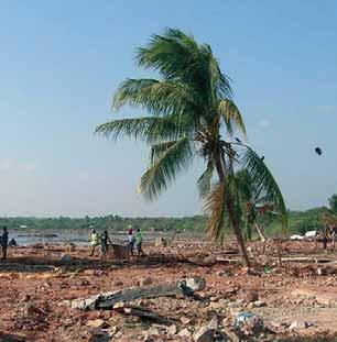
Many parts of Bangladesh are flooded every year as a result of rainfall and the overflow of river banks; the local population has adapted its livelihood strategies and agricultural practices accordingly. However, natural calamities such as major floods, tropical cyclones, tornadoes and tidal bores occur almost every year, varying in magnitude and intensity. Most parts of Bangladesh are less than 12 metres above sea level, and it has been calculated that about 50 percent of the land would be flooded if the sea level were to rise by just one metre5 . Floods such as flash floods, monsoon floods and localised floods after cyclones, or when embankments are breached, have a severe impact on people’s lives and the wider economy. In September 1998, Bangladesh suffered the most severe flooding in modern world history: two thirds of the country was underwater, there were 1500 deaths and 30 million people were left homeless. The floods caused severe damage to road infrastructure, standing crops and livelihood assets such as agricultural equipment and inputs, productive assets and livestock. The total loss to the economy was estimated at US$1200 million. The severity of the 1998 floods is explained by the unusually high monsoon rains that year, combined with a similarly high amount of melt water from the Himalayas. There was also serious forest and soil degradation throughout the watershed catchment area (upstream and downstream), which increased the water run-off6 .
Due to high population pressure and skewed landownership patterns, farming and settlements are increasingly pushed onto marginal land in areas at high risk of flooding. As a result, large numbers of people, especially the poor, are almost continuously exposed to flood related risks such as loss of life, crop damage, loss of assets (e.g. livestock and fishing equipment) and disruption to their livelihoods in general. When flooding occurs, vulnerable groups often lose their crops and assets, and may not be able to meet their daily needs or pay their loans. As a consequence, they are then forced to sell or lease out their land, resulting in changes in land tenure arrangements. One important example of such marginal, flood-prone areas is the highly unstable chars, the temporary lands within and adjoining the major rivers. Because these charsmay be ‘new’ land emerging as a result of sand deposition, landownership in these areas is at times highly disputed (see sections 2.5 and 2.6).
FIGURE 2 – Disaster Prone Areas of Bangladesh (by district)

Source: Country Emergency Situation Profile: Bangladesh, WHO.
1.2 Cyclones
Cyclones are very strong winds combined with intense rainfall. The 1991 Gorky Cyclone claimed 120 000 lives in Bangladesh and caused serious damage to livelihoods, assets and community infrastructure. The recent 2008 super cyclone, Sidr, affected more than nine million people in the southern districts of the country, and caused serious damage to housing, infrastructure, assets and standing crops. Compared to the Gorky disaster the number of deaths was considerably lower: more effective early warning systems were now in place and cyclone shelters were more widely available. However, the
5 Ali, A .1996. Vulnerability of Bangladesh to climate change and sea level rise through tropical cyclones and storm surges. Water, Air & Soil Pollution92 (1–2): 171–179. 6 Usually these events only occur every 50–100 years and they rarely coincide at the same time.
number of cyclone shelters is insufficient to cater for the number of people who need them, and usually the poorest sectors of the population living in high risk areas are too far from such shelters7 .
Like floods, cyclones can have a devastating impact on people’s livelihoods, as a result of loss of crops, livestock and other assets. The land they used to farm or live on may disappear completely, or be damaged to the extent that it is no longer suitable for cultivation. Families also run the risk of losing their title deeds and may no longer be able to prove their ownership of the land. For example, in Sri Lanka after the 2003 Tsunami, many families lost their title deeds; as some local government offices were also seriously damaged, there were no land records at all.
1.3 River erosion
Whereas floods and cyclones are recurrent, river erosion is a serious, continuous threat faced by people living near rivers and coastal areas. Given Bangladesh’s high population density and unequal land distribution, many of the rural poor are forced to live in flood- and erosion-prone areas along the rivers and the coast. It has been estimated that at least 20 000 families are made homeless because of river bank erosion every year. They are forced to migrate within their locality or to urban areas, joining the growing number of the urban poor. River erosion also affects local community infrastructure such as schools and colleges, mosques, markets, local clinics, hospitals and ports. For example, Chandpur – the biggest river port in the country and an important economic hub – has been severely affected by river erosion. Considerable funds have been invested to protect Chandpur from further erosion, but to little effect, partly because of a lack of strategic planning. When river erosion occurs quickly and suddenly, vulnerable groups may lose everything overnight. In other instances, river erosion is more gradual and people have more time to move their assets to a safer place. However, loss of cultivatable land and their homesteads is often inevitable.
The magnitude of land lost to river erosion can be large and is sometimes referred to as a ‘silent tsunami’. National figures on the number of people affected, the areas of land eroded, and the damage caused by river erosion, are daunting. Between 1981 and 1992, 728 000 people were displaced by river erosion, an average of 64 000 each year. In the char areas, an estimated 462 000 people were displaced during this 11-year period, amounting to around 12 percent of the char area population8. Recent national figures are even higher, indicating that more than 250 000 people are the victims of land erosion every year, and annual economic losses are estimated at TK 1000 crore9. Many of those who lose their land have no other option except to move to major urban centres such as Dhaka. Some find themselves living their lives on the street as pavement dwellers: even a shack in a slum is beyond their reach10. According to the Centre for Environmental and Geographic Information Services (CEGIS), 155 280 hectares of land were eroded between 1973 and 2007. Moreover, CEGIS forecasts that for the next few years, about 29 000 people per year living along the major rivers will lose their homes and land. River erosion has always been common in Bangladesh, but its increasing frequency and intensity in recent years is causing concern. Reasons for this trend include climate change, deforestation in the Indian and Nepalese Himalayas, the silting of river beds coupled with the absence of adequate and appropriate river management, and a growing population. Increasing population density means that more people are shifting their lives towards the river banks, making them vulnerable to erosion and flood damage11 .
River erosion also affects national borders. Bangladesh has been losing land to India and Myanmar as a result of border-river erosion. Over time the border rivers Surma and Kushiara have changed direction, shifting the original border so that it is deeper inside Bangladeshi territory, resulting in a huge loss of land to India. According to a government estimate, the country has already lost nearly 15 000 hectares of land, caused by erosion in the 15 rivers
7 Benson, C. and Clay, E. 2002. Bangladesh: Disasters and Public Finance. Disaster Risk Management Working Paper, Series No. 6. Washington, The World Bank. 8 ISPAN. 1993. Charland Study Overview: Summary Report. Environmental study (FAP 16) and GIS (FAP 19). Prepared for the Flood Plan Coordination Organization, Ministry of Irrigation, Water Development and Flood Control. 9 TK 1000 crore = TK 10 000 million = US$ 145 349 000 (1 TK – 0.0145349 USD). 10 During 2007, Concern Worldwide Bangladesh carried out a programme appraisal in Dhaka including a livelihoods assessment of the pavement dwellers. Pavement dwellers are defined as people sleeping on the street and having no fixed roof over their head. The total number of pavement dwellers was estimated at 10 000 for Dhaka alone. A significant number of these people mentioned river erosion as one of the reasons for moving to Dhaka. 11 Integrated Regional Information Networks (IRIN). Bangladesh: ‘River refugee’ numbers continue to swell. 1 August 2008. Available at: http://www.unhcr.org/ refworld/docid/4896c473c.html.
that are shared with India and Myanmar. The country's borders, defined in 1974 by the Indira–Mujib border treaty, have now changed considerably, given that the Indian sides of the rivers are better protected against erosion.
1.4 Drought
Although Bangladesh is known as a country with high rainfall, seasonal and contingent droughts caused by irregularities in rainfall do occur. The 1973 contingent drought contributed to the severe nationwide famine of 1974; most recently contingent droughts were also experienced in 1994 and 1995. Often coinciding with seasonal drought is the Mongaperiod, when food stocks run out and there are almost no job opportunities during the months of October and November, before the main harvest season in December. Monga is a seasonal famine which occurs every year in many regions of Bangladesh, and especially in some of the north-western districts such as Greater Rangpur and Dinajpur, which are severely affected. The situation is worse if preceded by devastating floods.
Thousands of poor people need to survive without adequate food for weeks. According to the WFP’s estimates, 80 to 90 percent of the affected people are agricultural day labourers, approximately 20 to 30 million people, who are forced to take consumption loans and migrate to other areas for work, leaving behind their families. Seasonal drought, combined with lack of agricultural wage labour, may put poor rural households under increased pressure to give up sharecropped and/or owned land, leading to further inequalities and concentration of landownership.
1.5 Earthquakes
Bangladesh is located in a region of significant seismic activity. Although most people do not perceive seismic risk to be of great importance, the occurrence of small magnitude earthquakes in Bangladesh is quite frequent. The zones most severely affected include the northern part of Dinajpur, Rangpur, Mymensingh, Sylhet, Tangail; similarly the northern part of Dhaka, Khulna, Jessore, Kushtia, and Chittagong, including the Chittagong hill tracts.
Earthquake records12 suggest that more than one hundred moderate to large earthquakes have occurred in Bangladesh since 1900, of which more than 65 events took place after 1960. Fifteen new epicenters have been identified inside Bangladesh since January 2001. The data clearly indicate an increased frequency of earthquakes in Bangladesh. Although Bangladesh is increasingly vulnerable to seismic activity, the nature and the level of this activity is poorly defined.
1.6 Landslides
Landslides often occur in the hilly areas in and around Chittagong and the Chittagong hill tracts, triggered by incessant monsoon rains, forest deforestation and hill cutting. A series of recent landslides between 2003 and 2008 have caused loss of human lives, homes and agricultural land. Although the links between deforestation, unsafe housing development practices in hilly urban areas and landslides are known and recognized, the government is not taking any action.
1.7 Climate change and natural disasters
Bangladesh is among the most disaster-prone countries in the world and has already suffered 170 large-scale disasters between 1970 and 1998. The frequency, intensity and scale of floods have increased, with eight major floods occurring between 1974 and 2004. Given current trends in climate change, and other triggers such as man-made disasters (e.g. deforestation, soil erosion), it is expected that the scale, intensity and frequency of disasters will also increase. The population of Bangladesh will need to cope with the impact of floods, droughts, cyclones and other extreme temperatures on a more regular basis13 .
These will not only affect the population and its livelihoods but also seriously affect infrastructure, such as port facilities and coastal embankments and structures.
TABLE 1 – Frequency of disasters, 1980–2009
YEARS COLD WAVES CYCLONES EARTHQUAKES FLOODS LANDSLIDES LOCAL STORMS DROUGHTS
1980–2009 16 46 6 +1 tsunami 66 1 60 2
Source: http://www.emdat.be/database/country profile.