34 minute read
3. Critical land issues after the natural disasters


levels. Land tenure is usually identified in the disasters and poverty analysis, but it is not dealt with in depth as an issue. The analysis carried out in this publication will help to improve understanding of land tenure in the context of natural disasters, and to foster more analysis and data collection to better assess the relationships between natural disasters and land tenure at national and local levels, especially in those countries that are prone to natural hazards.
The Mozambique case study identifies important lessons from the analysis of the impact that floods have had on land tenure in the Limpopo (2000) and the Zambesi valleys (2001 and 2007). The authors, Paul De Witt and Simon Norfolk, consider that the approach undertaken into national and legal frameworks helped to minimise the effects of the floods. This comprised the national policy on Disaster Management passed in October 1999, the legal framework for land including the Land Law (1997), the accompanying Regulations (1998), and the technical Annex on Community Delimitation (2000). While the Disaster Management policy marked an important shift from a reactive to a proactive approach towards disaster management and prevention, the land tenure legal framework promotes the involvement of local-level institutions in land access and management, with a focus on identifying and securing local land rights. The combination of both has been very useful in the way Mozambicans have addressed the main land tenure security issues that emerged after the floods.
Advertisement
The Bangladesh paper deals with the difficulties that Bangladesh, with long experience in the development of national and local mechanisms to respond to natural disasters, has had in addressing impacts on land tenure issues within such mechanisms. The author Salma Shafi, analyses how Bangladesh addresses the impacts of natural disasters in one of the most disaster-prone countries in the world, with a high population density and more than 45 percent of people living below the national poverty line. In Bangladesh the government developed several programs and mechanisms to respond effectively to the effects of natural disasters; these have included programmes at national and local level, with measures that enhance the capacity of the communities to deal with disaster risk reduction. Through the description of the current land tenure system characteristics and the related institutional setup, the author analyses the difficulties that such disaster management mechanisms have in the development of adequate measures to deal with the effects of natural disasters on land
tenure issues, including the political constraints. The author examines the 2007 Sidr cyclone to illustrate those difficulties. The study finally argues that more attention should be paid to land tenure and land use in national policy frameworks as well as in the specific land tenure, land use and disaster management programmes, concluding that failure to consider these issues effectively can be a key factor increasing poor peoples’ vulnerability to disasters.
In the Philippines case study the author, Luis Eleazar analyses the consequences of the major natural disasters that have hit the Philippines from 1990 to 2006, including the consequences on land tenure issues. The Philippines, consisting of over 7000 islands, has experienced 520 disasters from various types and intensities during this period. The author identifies three factors that played an important role in increasing or decreasing the severity of the consequences of these disasters: whether the affected people had secure or insecure tenure rights; whether the disaster caused lasting damage to the property; and finally whether the affected people had the capacity to recover their lost property, or to restore their tenure security. In the Philippines according to the author, this capacity is mainly defined by socioeconomic status. Important obstacles dealing with disasters include: the absence of a complete cadastre and the presence of incorrect cadastral surveys; the existence of incomplete and outdated land records; the cumbersome legal procedures for title records reconstitution or recuperation of title copies5. When analysing the impacts of natural disasters on land tenure within a framework of disaster risk management, the author mentions four major issues that land tenure emergency work should address for prevention and mitigation: (i) the formalization of land rights or the issuance of titles in areas considered highly vulnerable to disasters, (ii) the lack of an appropriate land use and development policy; (iii) the existence of dense human settlements in vulnerable areas, (iv)properties located in recently identified high-risk zones. In relation to the emergency response phase, the author underlines the need to give importance to the development of good assessments on property damage and the tenure rights situation of affected people, especially those who have been displaced as a result of the effects of the natural hazard. For the recovery and preparedness phase the author argues for the importance of support for land tenure issues related to the poor, vulnerable and food insecure households affected by the natural disasters. Finally, the author analyses the capacity and situation of the institutional set-up supporting land tenure and related natural resources access, both at national and local levels.
5 Some of these difficulties are already being addressed by technical assistance projects funded by international donors working in the field of land administration.
Fausto Jordán and Raúl Sánchez analyse the reactive response approach that government institutions in Ecuador had towards natural disasters during the period 1997-2008 and the new initiatives that the government of Ecuador has undertaken since 2008. In line with the process of adopting a new approach and developing a national disaster risk management system, the 2008 national Constitution includes the concepts of prevention and mitigation for natural disasters risk management, as well as the need to deal with the management of risks on a decentralised basis. The Constitution states the need to establish a national system for the prevention and management of natural disasters. Since May 2008 a new government agency has been created to deal with risk management. This institution includes land tenure access and security responsibilities. The analysis draws on the impacts of several types of natural hazards like volcanic eruptions, floods, and landslides that have not been covered in the other country studies. The importance of the collaboration between public and private sector in a decentralised manner, is also highlighted in the analysis as a very important part of the national disaster risk management system in Ecuador.
This publication was prepared by Adriana Herrera Garibay, Land Tenure Officer from the Land Tenure Team in the FAO Climate, Energy and Tenure Division, with the help of the authors, Paul De Witt and Simon Norfolk, Salma Shafi, Luis Eleazar, Fausto Jordán and Raúl Sánchez; with the support of the editors, Nicoliene Oudwater and Damian Bohle; and with the close collaboration of Claudia Tonini, responsible for the layout of the publication. The country case studies papers received valuable comments from UN-HABITAT and the Emergency Unit in FAO.
Rome, September 2010 Paul Munro-Faure Principal Officer Climate, Energy and Tenure Division Food and Agriculture Organization of the United Nations
Mozambique
Mozambique
by Paul De Wit and Simon Norfolk*
■ 1. MOZAMBIQUE – RECURRENT FLOODS, CYCLONES AND DROUGHT ■

Mozambique’s geographic location makes it susceptible to natural disasters of a varying nature. It includes the lower parts of two major southern African watersheds, the Limpopo and the Zambezi. Water collected in the four Limpopo river basin countries (South Africa, Zimbabwe, Botswana and Mozambique) drains through the Gaza province of southern Mozambique before reaching the town of Xai–Xai and the Indian Ocean. The Zambezi watershed is the fourth-largest river basin in Africa, and waters from Tanzania, Malawi, Zambia, Angola, Namibia, Botswana, Zimbabwe and Mozambique all flow through the lower Zambezi valley in the provinces of Sofala and Zambézia. This situation provides Mozambique with a series of excellent economic opportunities – such as harbours, hydro-electric power plants, fertile valley land, highly-valued tourist sites, and specific ecologic settings such as mangroves – but also exposes rural people to frequent floods.
Throughout its history Mozambique has had to cope with a succession of cyclones and related floods, which have had a devastating impact on the country. Between 1970 and 1998, Mozambique experienced 11 flood events and more than 16 drought events. In the 11 flood events, it is estimated that more than 1585 people died. Apart from the immediate threat to human life, such natural disasters seriously impede economic growth. In August 2007, for example, Mozambique’sNational
FIGURE 1 – Geographic areas of natural disasters in Mozambique Institute for Disaster Management (INGC) announced that the joint effects of drought, cyclone ‘Favio’ and the floods that hit the country in the first quarter of 2007, had reduced agricultural production by 30 percent in the central and southern regions of Mozambique. A significant part of the country is also susceptible to drought. Most of the Mozambican Limpopo valley lands have annual rainfall that rarely exceeds 800 mm, with most areas
The picture on the left illustrates areas affected by natural hazards – floods, drought and receiving less than 600 mm. The cyclones – as identified by historic data and the floods of 2008 (GAC/SETSAN on irregular and erratic distribution www.alertnet.org/thenews/newsdesk/FEWS/52674e740d15acf800ac87f 591341527.htm). It is clear that the southern part of Mozambique is very susceptible to regular droughts, pattern of this rainfall turns the lower whereas floods are a major hazard in the centre, especially in the Zambezi valley. The Limpopo valley into a drought-prone occurrence of regular lower-Limpopo floods are indicated in the right-hand picture (Atlas for area, with the river itself being the
Disaster Preparedness, 2003). The latter considers a flood scenario on the basis of a slightly spine of rural survival. The state andreduced flood as compared with the unprecedented 2000 floods. the local populations have adapted

* Mr. De Wit is a senior land policy and land administration expert with wide experience in African countries. He has been collaborating with FAO, UNHABITAT, World Bank, European Union, among others, in land tenure policy and legal framework project formulation, as well as research, particularly in Mozambique, Sudan, Burkina Faso, Liberia, Botswana and Bosnia Herzegovina. * Mr. Norfolk is a land tenure and administration expert in Mozambique. He has been collaborating in the formulation and implementation of land tenure projects and research papers in Mozambique with national and international institutions such as FAO, Millennium Challenge Corporation, World Bank and others.
their strategies to these extreme climatic conditions: over the years the state has developed major irrigation schemes (in Chokwe and Xai–Xai districts), while local populations explore the fertile lowlands whenever they can.
Of Mozambique’s 138 districts, 20 are ‘highly prone to drought’, 30 to flooding, and another 7 to both risks (Rohrbach et al, 2001, page 39). Overall, 48.2 percent of the population suffers one, the other, or both risks.
In addition, the 2500 km of Mozambican coastline is directly exposed to the very active tropical cyclone belt of the southwest Indian Ocean basin, which accounts for 10 percent of the entire world’s cyclones. Tropical cyclones hit the Mozambican coast line on average once a year (most risk prone areas are located between Pemba and Beira), with minor events occurring some three to four times a year. Climate change is likely to increase the frequency of these events. Cyclones bring direct destruction of infrastructure, but also highintensity rainfall in extreme volumes, which often results in flash floods and adds to the downstream water floods from upper catchment areas.
Population densities in coastal flood-prone areas seem to be higher than in a number of neighbouring, mainly inland, districts (Quelimane, Chinde and Caia along the Zambezi; Xai–Xai, Chibuto and Chokwe along the Limpopo). The recurrent nature of the floods in Mozambique creates a significant financial burden on the government. It is estimated that the total costs of the 2000 floods was equal to almost 20 percent of GDP, and slowed down the economic growth rate by 2.1 percent. However, dry estimates of costs and recovery needs do not necessarily capture the hardship and long-lasting effects of natural disasters on the livelihoods of ordinary rural people. The massive loss of livestock in Gaza province in the year 2000, for instance, undermined the livelihood strategies of an important part of the population and left rural communities much more vulnerable than they were before the floods. Similar impacts can be observed with the fishing communities along the river in the Zambezi valley. Immediate emergency and relief operations – which among other measures generally include the distribution of seeds and tools, fishing nets, and the introduction of sweet potatoes – are of course essential, but do not necessarily address the structural losses, or help to replace the core assets needed for people to make a durable recovery.
TABLE 1 – Overview of the major natural disasters over the last 30 years
EVENT FLOODING
IMPACT EVENT DROUGHT
IMPACT EVENT CYCLONES
IMPACT
1978 – Limpopo 350 killed; 1980 South and 1984 Cyclone 350 000 affected; 5 million affected; 400 000+ affected central including Domoina 109 killed 100 000 killed Limpopo basin (partially in 1981 – Limpopo 500 000 affected 1981–83 South and 1988 cyclone Filao 90 000 affected; 100 central including killed combination with war) Limpopo basin 1985 – Southern 500 000 affected 1983–84 Limpopo March 1994 Cyclone 900 000 affected; Provinces basin Nadia 52 killed 1990 – 12 000 displaced 1987 Inhambane 8000 affected January 1996 200 000 affected; Pungue-Sofala Cyclone Bonita 11 killed 1996 – Southern 200 000 affected 1991–93 whole 13 million affected January 1997 80 000 affected; rivers and Zambezi country Cyclone Lisette 87 killed 1997 – Central rivers 300 000 affected; 1994–95 South and 15 million affected February 1997 300 000 affected and Zambezi 78 killed central Mozambique Cyclone Gretelle including Limpopo 1999 – Inhambane 70 000 affected; 1999 100 000 affected February 2000 See the of the impact and Sofala provinces 100 killed Cyclone Connie 2000 floods 2000 – Southern 2 million affected; 2002 South and 43 entire districts February 2000 rivers including 700 killed central Mozambique affected Cyclone Eline Limpopo including Limpopo basin 2001 – Zambezi 500 000 affected; March 2000 115 killed Cyclone Gloria
2007 – Zambezi January 2003 47 killed Cyclone Delfina
2008 – Zambezi March 2003 23 000 affected Cyclone Japhet February 2007 40 killed; Cyclone Favio 120 000 affected

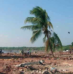
©FAO/L. Dematteis
■ 2. RECENT NATURAL DISASTERS AND THEIR IMPACT ■
Three major flood events, those of the Limpopo valley in 2000 and those in the Zambezi valley in 2001 and 2007, are considered especially relevant to addressing and analysing land issues in post-disaster situations.
2.1 Flood events in the Limpopo valley, 2000
There is no doubt that the Limpopo valley floods of 2000 were the worst natural disaster in the history of modern Mozambique. It is estimated that up to 700 people died; some 500 000 to 650 000 people were displaced and temporarily sheltered in over 100 camps set up by the GoM; 27 percent of the total population were affected in one way or another. The towns of Xai–Xai, the provincial capital of the Gaza province, and Chokwe, a district capital, were hit hard. Xai–Xai had developed as a small inland harbour town, with most of its facilities (such as administration, commerce, food storage places) located in the lower part of the town, which was highly flood-prone. The surrounding dunes and other higher parts are considered to be an extension of the centre, populated mainly by new dwellers and returnees after the civil war. Chokwe is a town located in the centre of a wide flood plain, upstream of Xai–Xai, and known for its irrigation scheme. After the 1977 floods some 12 000 victims were resettled on government land within this irrigation scheme. The presence of the scheme in the valley illustrates well the dual challenge that rural people and the GoM face when dealing with natural disasters. On the one hand, irrigated agriculture is a mitigation measure against the recurrent periods of extreme drought in the region. On the other hand, promoting settlement in the valley can result in major consequences when extreme floods occur.
Damages in both urban areas were severe; thousands of houses were destroyed, as well as most of the infrastructure such as roads, bridges, railways, water and sanitation systems and electricity supplies1. The main national North–South road linking a large part of Mozambique with the capital, Maputo, was blocked for several months, causing major problems for the transfer of goods across the country. The impact on the rural population in Chokwe (approximately 50 000 people affected; 247 casualties in total) was far greater than in Xai–Xai (1500 people affected; 38 casualties in total). This was largely due to settlement patterns (communal villages in the uplands of Xai–Xai, valley villages in Chokwe), and the distance to safe havens (a maximum of 3 km in Xai–Xai, but up to 30 km in Chokwe). Figure 2 illustrates clearly the different breadths of the flood inundations around Xai–Xai (south of the picture) and Chokwe (north of the picture)2 .
The floods decimated the agricultural sector which remains the major economic activity of most affected
1 In an early assessment the World Bank estimated a direct cost of US$ 270 million, and an indirect cost of US$ 215 million. The reconstruction costs were estimated at US$ 428 million. Some 11 000 houses were destroyed in Chokwe alone, and an estimated 36 160 all over the country. 2 http://www.reliefweb.int/rw/RWB.NSF/db900LargeMaps/SKAR-64GC75?OpenDocument&emid=FL-2000-0012-MOZ&rc=1.
FIGURE 2 – Areas of the 2000 flooding in the lower Limpopo valley

people. FAO3 estimated that due to the prolonged nature of the inundations some 140 000 hectares of crops (over five provinces, but with Gaza accounting for 41 percent or 57 000 hectares), mainly food crops such as maize and sorghum, were destroyed or seriously damaged, as well as major irrigation systems and pump installations in Xai–Xai (Magula, Ponela, Chimbonhanine), but even more so in Chokwe, which was once the pride of ‘modern’ agriculture in Mozambique. Later in the year, cereal production on receding and residual soil moisture proved to be extremely high.
The estimated loss of livestock varies considerably, from 30 000 (by the World Bank in the early stages) to 350 000 destroyed or seriously injured animals (estimates at the national level made by FAO at the end of March 2000; the March 2000 FAO Appeal). There is evidence that a significant number of cattle holders did not want to abandon their livestock, even when the floods reached high levels. Comments such as ‘Cattle are our bank’ reflect the value of livestock in the smallholder sector. Other comments such as ‘When drifting under the tree tops towards the sea, animals were crying’ indicate the close link between people and cattle.
Direct losses to the agricultural sector were estimated at US$65.81 million, with the damages to the smallholder sector accounting for half of that amount. Artisan fishermen in the Limpopo basin, who had reported catching about 650 tonnes of fish in 1999 using mostly gill nets, saw their catch drop dramatically in 2000, down to about 200 tonnes, due to floodinduced equipment losses (Barnes et al.2002).
The population was exposed for some months to an increased risk of disease, especially cholera and malaria, but efficient public health services adequately dealt with these threats. Annex 3 gives details on the disaster-related costs covering all sectors (US$488 million), as well as an assessment of the relief needs (US$65 million) and reconstruction needs (US$428 million).
2.2 The Zambezi valley floods of 2001 and 2007
In the Zambezi valley the patterns of flooding have changed considerably over the last 50 to 60 years. Before the construction of the Kariba Dam in 1959, there was usually an annual flood in February or March of each year. A second dam was built at Cahora Bassa in 1974, to further control the water levels. The new dams halted these annual floods, which encouraged many people to move into the lowlands around the Zambezi, where the soil is more fertile. However, while the dams can control the flooding in normal years, they do not have the spillway capacity to cope with the very large floods that occur on the river every five to ten years. At best, the dam operators can slow down the sudden rise in water levels by phasing the spillage of water over a period of a few days, which gives the people living downstream a little more time to evacuate their homes (Foley, 2007).
Estimates of the impact of the 2001 floods included 113 deaths, with over 230 000 people displaced and over 550 000 people affected around the Zambezi river valley and within rain affected areas of Zambézia province (Leira, 2001).
The economic impacts were widespread. In March 2001 the retail price of maize rose by 26 percent in Beira, the provincial capital of Sofala; in Chimoio, the capital of Manica, prices rose by 38 percent (maize) and 16 percent (beans and peanuts). By April 2001 it was reported that 42 000 hectares of food crops had been lost due to the flooding, although FewsNet later reported a figure of 79 000 hectares (FewsNet, 2001). First season production was said to have decreased by 40–80 percent, following two successive seasons of crop loss. In November 2001 maize prices were at a record level of 350 000 meticais per 70 kg sack. Data from the Banco de Moçambique indicated that the metical had depreciated against the dollar by 9 percent in the first three months of 2001, partly caused by the destruction of infrastructure as a result of the floods.
THEFLOODSOF 2007 From the end of January 2007 the level of the Zambezi river again began to rise rapidly because of local heavy rain in the Zambezi valley, as well as discharges from the Kariba Dam upstream and the flow from the river’s tributaries. By February it had burst it banks and flooding occurred throughout the lower reaches of the river. The situation was aggravated in Sofala province, affected by Cyclone Favio which struck in late February.
During the floods of 2007 over 400 000 people were said to have been affected by the combined severity of the flooding and the cyclone which struck Inhambane and Sofala provinces. The flooding caused 45 deaths, extensive crop damage, and the evacuation of around 163 000 people from low-lying areas.
A further 122 000 Mozambicans lost crops when their fields were flooded, although their homes and storehouses survived. Cyclone Favio devastated the town of Vilanculos, resulting in 10 deaths and 70 injured, and causing extensive damage to infrastructure and property. An estimated 150 000 people were affected in the districts of Vilanculos, Inhassoro, and Govouro, as well as along the Buzi river in southern Sofala province.
Estimates by the Ministry of Education indicated that the flooding in the provinces of Zambézia, Tete, Sofala and Manica prevented 130 000 pupils from attending school, just as the school year was beginning, in 392 schools in the four provinces.
Ministry of Health nutritional surveys conducted inside and outside accommodation centres in selected districts in Sofala, Tete, Zambézia and Manica found high levels of malnutrition among children under five years of age, ranging from 12.3 percent to 19.9 percent.
Box 1 shows the results of a survey by SCF–UK, conducted in October 2007, concerning the areas affected by the floods during February and March 2007 in Zambézia Province. One hundred and eighty one households were surveyed in 13 communities; seven in Mopeia district and six in Morrumbala district. Members of the households were interviewed from both inside and outside the resettlement areas.
■ 3. CRITICAL LAND ISSUES AFTER THE NATURAL DISASTERS ■
3.1 An enabling environment to prevent natural disaster related disputes
An examination of land rights and land issues in the postdisaster situations that Mozambique has faced reveals a common thread: major disputes and conflicts are generally absent. This is true of the post-conflict period, as well as the post-flood events that form the focus of this paper. It is worthwhile examining some of the principle reasons for this, as they will provide some important lessons on efforts that may be required to prevent these disputes happening in the future.
BOX 1 – IMPACTS OF THE FLOODS IN MORRUMBALA
Livelihood and food security impacts of the 2007 floods included: • The majority of the households in the flood-affected areas had managed to harvest cereals during the second cropping season, but on a lesser scale than previous years. •The main food source for households in resettled areas was food aid, followed by household production (25 percent) and the purchase of food (20 percent). •Outside the resettlement areas the main source of food was household production (44 percent) followed by the purchase of food (41 percent). •The main sources of income for the households affected by floods are fisheries, seasonal work/piece jobs, informal trade, and sale of crop production. •Fewer households in resettlement areas fish as a primary source of income, largely due to the loss of fishing equipment during the floods. •61 percent of the households in resettlement areas do not have any fishing equipment, compared with 60 percent of households with fishing equipment outside the resettlement areas. •Ownership of livestock is very low, with 35 percent of the households in the surveyed zones owning no livestock, and 25 percent owning only one animal. •Households in the resettlement areas have significantly less livestock than those outside of the resettlement areas. •99 percent of the households in resettlement areas have access to water from a well or a borehole with a pump, compared with only 35 percent outside of the resettlement areas. •Overall 17.2 percent of households changed the location of their cultivated land since the last planting season, of which 73 percent stated that they had moved due to the floods (this was followed by 23 percent that moved due to infertility of the soil and 3.8 percent due to drought). •All households confirmed that they planted more cereals during the second agricultural season in April 2007 due to the weak harvest of the first season crops; however, the overwhelming majority said that in total the production was less compared with the 2006 second season crop.
Source: SCF–UK, 2007.
•Resilience to disaster.
Over the past ten years, work on disasters has increasingly focused on the capacity of affected communities to recover with little or no external assistance. This requires a stronger emphasis on approaches to risk reduction and humanitarian and development work that put resilience, rather than just need or vulnerability, at the heart of the debate (IFRC, 2004). After independence from Portugal in 1975
Mozambique endured a 16-year civil war that was ended by the 1992 Peace Agreement. During this period, hardship was exacerbated by a number of natural disasters: the floods of 1977 and extreme droughts in the early and mid 1980s. It appears that the Mozambican people have established a high degree of resilience to the recurrent character of these disasters. •Livelihood strategies to respond to the occurrence of disaster.
In the Gaza province and other dryland areas, strategies to minimize risks of economic hardship have been developed over time. These include a diversification of agricultural production in time and space, having access to different types of lands and soils, and making alliances with neighbours to secure this access. Losing one or two parcels due to the occurrence of a disaster is compensated for by arranging access to parcels in different locations. •Solidarity and social networks.
Strong forms of solidarity remain part of Mozambican society. In rural Gaza, the Changanas (dominant regional social group) have developed solidarity systems such as Kofunanaand Tsima. Similar traditional mutual help systems exist in the Zambezi valley, such as Macuti and Cufuisa. •Absence of major ethnic, social and political differences.
Mozambique is a multi-cultural society but has remained largely immune to confrontations or conflicts defined along ethnic lines. •Land availability.
Post-disaster situations are not, as yet, being used by groups or individuals to gain access to land or natural resources, and in general there remains a relative abundance of land for agricultural development. Private land concessions are an established practice in the
Limpopo valley and seem to meet the consent of local populations. Larger concession holders are not yet massively encroaching upon smallholders or communal land (although more recent reports indicate an increasing interest from the agro-fuel sector). In the
Morrumbala and Mopeia districts of Zambézia the
threats to land access have so far manifested themselves through the marginalisation and exclusion of some communities from the hardwood timber forest areas, rather than from the arable or pasture land in the low-lying valley areas. Land remains in reasonable abundance in both Mopeia and Morrumbala and the limits to land production tend to be related to the availability of family labour. However, it is possible that this situation will begin to change as stocking levels of livestock begin to recover, a process that has only happened slowly to date. The history of the river margins in Mopeia and Morrumbala is one of extensive use of pasture land, and local community elders still remember the days when vast herds of cattle belonging to colonial companies were corralled all along the banks of the Zambezi river. There are already some localised conflictive incidents, largely as a result of the stocking of water buffalo, which are allowed to graze un-herded and cause significant damage to local machambas. •Informal but strongly legitimate land rights and local institutions.
Decision-making on land management, including dispute resolution, continues to be dealt with primarily via informal but mostly legitimate institutions at the local level. Both displaced people as well as those who receive the disaster victims often use these same institutions to take care of their problems and challenges. The strength of the institutions’ legitimacy is recognized by the Land Law: customary land rights exist and are recognized as such. They do not need to be prescribed. Local people also accept these rights, which are based on the occupation of and use of the land. This offers major advantages in that formal documentation is absent. It also empowers oral testimony in case this is required, and local solutions to problems.
3.2 Land issues for the displaced
In the Limpopo valley floods of 2000, the temporary settlement of up to 650 000 people was an operation that went ahead without any significant preparatory efforts. There is evidence that some of the selected sites coincided with locations that were used after the 1977 floods. However, most of the sites were identified on the spot, sometimes in places where rescuers dropped off flood victims from helicopters or rubber boats.
The distance between the places of origin and the accommodation camps varied according to the morphology of the valley and the presence of safe havens
on high ground. The accommodation camp of Xai–Xai 2000, also called Ndambine(‘floods’ in the Xangana language), which turned into a permanent and to some extent ‘example’ resettlement village, is situated in the outskirts of Xai–Xai town, less than 10 km from the flooded centre, just outside the municipal boundary4 . One of the biggest resettlement camps in Chokwe district, Chiaquelane (accommodating up to 60 000 displaced people at one stage) is, however, located at a distance of 30 km from the flooded centre. Another refuge town, Macia, is some 60 km from Chokwe town. All three centres have developed from places of temporary shelter into permanent resettlement sites.
Similarly, in Zambézia in 2001, and to a lesser extent in 2007, local populations either fled themselves, by canoe, or were evacuated to areas of safe higher ground which were easiest to access. Thus in 2001 and 2007 the community of Cocorico, which occupies an island within the river system, was forced to head for the Sofala bank instead of to Mopeia on the Zambézia side, an area where they felt more ‘at home’ from a cultural and administrative perspective. In 2008 the regulo and his people managed instead to reach Mopeia, which is closer to their area of origin, and where there have been attempts since the 2001 floods to establish permanent resettlement areas. In Morrumbala, the situation is different: here, most of those displaced in 2007 and 2008 were able to return to land that they had already been allocated in the higher areas during the 2001 floods.
STRENGTHENINGTENUREARRANGEMENTSTHROUGH VISIBLEOCCUPATION Upon arrival, flood victims were registered by relief agencies or the state authorities, making them eligible for emergency assistance. It was also on this basis that plots of land were allocated in the resettlement villages. In the majority of cases, this registration, supplemented by an index map where each plot number corresponds with the name of a resettled person or family, is the only documentation that secures any tenure over the land and property. None of the communities interviewed in Zambézia had any documentation relating to their newly allocated parcels of land and, although they were aware that a general map of the residential area had been compiled by the provincial services of MICOA, a copy of this was not available locally, even at district level.
Maintaining secure access to productive assets such as land in the area of origin, but also to employment, is a core livelihood strategy that flood victims have adapted as part of a post disaster response. Permanent occupation of land, or the exercising of highly-visible land use, is an accepted way of establishing strong rights over land. This is part of the customary heritage of all social groups. Successive post-independence governments have also embraced this policy, on the basis that ‘land belongs to those who use and cultivate it’. Resettled flood victims have used this strategy to strengthen their tenure security. They have tried to occupy both the lands that they had to leave and the newly-allocated lands. When distances between the two sites become too important, families tend to split up, and establish some form of presence on each plot.
The use of customary embedded practices by resettled people to acquire stronger rights over their allocated land continues to be used widely. The planting of fruit trees is very popular in resettlement villages. The presence of fruit trees on land (cashew, mango, papaya, etc.) establishes strong rights over that land. It is proof that the land belongs to someone, and, when occupied by an outsider, it may be reclaimed. Some NGOs have been promoting fruit tree planting as part of resettlement efforts. There are also efforts in some flood-susceptible locations to plant trees along the parcel boundaries.
The ‘removal’ of fruit trees that are found standing on an allocated plot in a resettlement village is a common strategy to erase proof and support a potential future claim over the land. These claims do sometimes occur and are lodged by living members of the host community, who still use the land. It is by decision of the state that they are excluded from land use on their own land. This practice creates common disputes.
The integration into existing structures of host communities, and acquiring land through local customary authorities, is a method used by a number of resettled households that want to have secure access to additional land in the neighbourhood of resettlement sites. However, upland is much easier to access in this way than more valuable lowlands.
RESETTLEMENTONCOMMUNITYLAND Resettlement programmes are organized by the local authorities (often district administrations), or local (municipal) and provincial governments. For a number of resettlement places in the vicinity of towns, some sort of outdated town plan usually exists. These plans have no provisions for emergency resettlement. In the best cases, areas earmarked as possible extension sites for town development could have been used for the

©FAO/J. Spaull
resettlement of flood victims. In practice this did not happen, mainly because local governments did not want to see their future prime land being occupied permanently by displaced people.
Most people are actually resettled on community lands in rural areas. This is a laudable policy, as it may offer at least the minimum conditions necessary to engage in economic activities that will support local livelihoods. Local communities have established rights over these lands through long-term occupation, according to local rules and customs. Community land rights are recognized by the Land Law, and can be made visible by the community land delimitation processes. Local land management institutions, as well as a significant part of the community members, often have a clear idea of the position and extent of the community boundaries. The land policy and law embrace negotiations and community consultations as mechanisms for outsiders to obtain access to community land. The community, represented by a local land management body, agrees or disagrees with the request for access to land and the use of this land under certain conditions. The latter may refer to the duration of the right to use the land, but also to the benefits that this temporary transfer entails for the community.
Resettlement locations on community land are identified by the local government authorities or district administrations, with the involvement of local community representatives. There is evidence that community representatives are not necessarily the same people as those identified in the Technical Annex to the Land Law, i.e. the so-called G95. They correspond more with local political leaders, who have established privileged relations with the state (in Gaza), or local traditional leaders, who have greater legitimacy within the local context than the state or state-recognized leaders (in Zambézia). The consultation process that identifies suitable resettlement spots is more likely to correspond with a decision taken after some ‘superficial consultation’, rather than a decision based on negotiation. This fast action appears to be justified by urgency, but may result in friction and problems later on between the resettled peoples and the host community.
Consequently, public institutions such as the former INPF (now integrated in MICOA), the Provincial delegations of Public Works and the SPGC, initiate a process of surveying and parcelling plots. Surveying appears to have presented major challenges in the past. There is a weak capacity to deliver services, a lack
of coordination between different agencies, and a lack of norms and standards. As part of recent resettlement efforts in Zambezia, MICOA and other partners seem to rely now on the training of locally-selected youngsters to provide basic surveying services. Young volunteers from local communities who have acquired a minimum threshold of school education are trained on-the-job in basic surveying techniques, and in the production of simple parcel layout plans. Once a certain level of expertise is reached, these ‘basic parcelling technicians’ are considered to be trainers for other small teams in neighbouring areas6 .
TRUSTINTHESTATETOGUARANTEELAND ANDPROPERTYRIGHTS The only security of tenure that resettled flood victims acquire over their land and home is based on trust in the local administrative state structures. They are not issued any kind of certificate or DUAT for the acquired plot; neither do they obtain a building licence for the shelter or home. The state is still very much respected, at least in the southern parts of Mozambique, and this trust may provide certain levels of perceived tenure security. But, in most of the cases in Gaza and in at least one area in Zambézia, the state did not in fact acquire the land for resettlement through an ‘official legal’ agreement from the host community. The host community could, in principle, question at any moment the validity of the resettlement site. In this context the question arises as to why the state does not sign a legally-binding agreement with the host community, such as an official community land delimitation, followed by a genuine negotiation of access to community land according to the Land Law. The lack of any preventive action, combined with the urgency to act when a disaster occurs, is probably the major reason why a negotiated agreement is substituted by a more imposed form of agreement.
On the other hand, the state has access to other mechanisms to secure land for resettlement; for instance, by using expropriation for a public purpose, as happens in urban areas. This is a much stronger and less negotiated form of accessing community land, but also guarantees, when implemented well, that the host communities will receive adequate compensation. It also strengthens the position of the state, or local authorities, in providing sufficient tenure security for the resettled flood victims, at least when there is a desire to do so.

©FAO/C. Shirley
GRADUALSTRENGTHENINGOFWEAKTENURE ARRANGEMENTS Initial trust in the state to secure tenure for resettled flood victims appears to fade away when the victims are confronted by host community members who reclaim their land, sometimes with outsiders who spontaneously settle on the outskirts of resettlement villages (to take advantage of new opportunities created), or with local state authorities themselves. There are cases where the infrastructure allocated as part of resettlement schemes has been re-allocated to outsiders by the local authorities. There is also anecdotal evidence of some plots being traded by local authorities, or of the multiple allocation of plots to different beneficiaries. All of these situations undermine good faith in the state as a guarantor of tenure security.
After several years, when initial gratitude has given way to real-life challenges, plot beneficiaries realize that they require a more direct form of tenure security. For instance, in Xai–Xai 2000, individual households are applying now for (i) the registration of their plot as a formal DUAT, to secure the plot, and (ii) a (post-factum) building licence to secure the infrastructure on the plot. This pro-active registration process originates in the resettled community itself, as a response to a perceived