CHAPTER 8 DEVELOPMENT
ARTICLE V - SIGN STANDARDS
[Article V – “Sign Standards” repealed and created in Chapter 11 by Ord. #2023-07 passed December 19, 2023]
ARTICLEI - ZONING STANDARDS
INTRODUCTORY PROVISIONS
8.0001Title. The City of Redmond Zoning Standards is contained in Sections 8.0001 through 8.0999 herein inclusive.
8.0010Purpose. These standards are adopted for the purpose of promoting the livability, health, safety, peace, comfort, convenience, economic well-being and general welfare of the City and not limited to, but specifically to achieve, the following designated objectives:
1. To protect the character and values of land and buildings and economic stability of sound residential, business, and industrial districts and to enhance the quality of the desired environment in them by:
A. Preventing the intrusion of inharmonious uses.
B. Preventing the encroachment on desirable open space appurtenant to each district.
C. Providing for the safe and efficient movement of existing and prospective traffic.
D. Assuring the provision of necessary off-street parking space for vehicles.
2. To provide for additional growth and development in a manner appropriate to the character of the City and which will contribute to the economic stability of the City and strengthen the basis of its private and governmental economy.
3. To assure that future development occurs in an orderly manner and is relatively compact to provide for economy and efficiency in public services and utilities and to protect the City from costs which may be incurred when unsuitable, scattered, or premature development occurs.
4. To assure satisfactory physical relationships between districts of different use characteristics and among uses of various types and to minimize conflicts among land uses.
5. To minimize traffic hazard, traffic congestion and the conflict between land uses and the movement of traffic, and to encourage alternative transportation means to automobiles.
6. To preserve the various City areas' right to be attractive and pleasing in appearance and to aid in the development of the city by assuring that development in areas of higher density or of commercial or industrial use and along appropriate routes of travel is neat, orderly, and attractive.
7. To regulate the placement, height, and bulk of buildings; and the placement and growth of vegetation within the City to ensure access to solar energy by reasonably regulating interests in property within the City, as authorized by Law, to promote and maximize the conservation of energy by preserving the option to utilize solar energy and to implement the Comprehensive Plan policies relating to solar energy.
8. To encourage the design of new buildings, structures and developments which use solar energy and protect future options to use solar energy by protecting solar access, and by having sustainable development as a goal.
9. To assure that middle housing is part of new neighborhood development consistent with the Great Neighborhood Principles and the community need to increase affordable and workforce housing.
10. To assure annexation in an orderly manner and integration of affordable and workforce housing.
[Section 8.0010 amended by Ord. #2022-04 passed June 28, 2022]
8.0020Definitions. As used herein, the following words and phrases shallmean:
Abut. Having a common border with or being separated from such a common border by arightof-way, alley, or easement.
Access. The right to cross between public and private property.
Access Management. The process of regulating access to streets, roads, and highways.
Accessible Route. Acontinuous unobstructed path connecting all accessible elements and spaces of a building or facility. Interior accessibleroutes may include corridors, floors, ramps, elevators, lifts, and clear floor spaces at fixtures. Exterior accessible routes may include connections to the public right-of-way, parking access aisles, curb ramps, crosswalks at vehicular ways, walks, ramps, and lifts.
Accessory Dwelling. See Dwelling, Accessory Dwelling.
Accessory Structure. A non-dwelling structure incidental and subordinate to the main structure and located onthe same property as the mainstructure.
Accessory Use. Ause incidental and subordinate tothe mainuse of a property and located on the same property as the main use.
Acreage, Gross. The total area within a unit of land.
Active StylePark. A park designed for active recreation no less than 15,00 squarefeet in size and consolidated shape. Examples of active-style park components include sports play areas, exercise equipment units, public/family gatherings with picnic shelters or tables, play structures, or designated pet areas. Active-style parks commonly feature some passive recreation features, but only as a secondary use. See also Passive-Style Park.
Active Recreation. Recreational activities which require coordination or equipment, taking place at a prescribed location, such as sites or fields. See also Passive Recreation.
Adjacent. See Abut.
Adjoining. See Abut.
Administrative Decision. A discretionary action or permit decision made without a public hearing but requiring public notification and an opportunity for appeal.
Adverse Impact. Negative effect of some action governed by this Code.
Affected Person. Owners of record of real property located within aminimum distance of 100 feet, exclusiveof public street and other rights-of-ways, from the propertysubject to and affected by a decision.
Affordable Housing. Affordable housing is generally defined as housing within the means of a household that may occupy low- and moderate-income housing, meetingone of the thresholds defined in this section. Affordable Housing warrants low- and moderate-income affordability deed restrictions of at least 30 years. The affordability period may be adjusted based on the use of development incentives, modifications, variances or exceptions.
In the case of dwelling units for rent, “affordable” means housing for which rent and utilities are nomore than 30 percent of the gross annual household income for a family earning less than or equal to 60 percent the Area Median Income (AMI), based on the most recent HUD Income Limits for the Bend-Redmond Metropolitan Statistical Area.
In the case of dwelling units for sale, “affordable” means housing in whichthe mortgage, amortized interest, taxes, insurance, HOA and associated fees, if any, constitutes no more than 30 percent of such gross annual household income for a family earning less than or equal to 80 percent of the Area Median Income (AMI), based on the most recent HUD Income Limits for the Bend-RedmondMetropolitan Statistical Area.
Agent. Any person who is authorized to represent or act for any other person.
Alley. A public or private way reserved as a secondary means of accesstothe back or side of a property and not intended for transporting through traffic. Alternateuseof an alley is permissible when determined to be in the public interest. Alter. To change, add to, or modify a structure or a use.
Architectural Theme. The use of arepetitive and dominant element or style to create a unifying and coherent form of construction.
Arena, Indoor. Afacility intended to enclose spectator sporting events.
Auto Detailing. Ause designed for cleaning the inside and outside of autos, not including an automated car wash.
Auto Sales. Commercial sale of new or used autos.
Auto and TireService. A commercial business engaged primarily in supplying services generally required in theoperation and maintenance of automotive vehicles. Major automotive repairs, painting and body and fender work, are excluded from this definition.
Automobile Recyclingor Wrecking Yard. A premises used for the long-termoutdoor storage and sale of used automobile or truck parts.
Awning. A sheet of canvas or other material stretched on a frameand used to keep the sun or rain off a storefront, window, doorway, or deck.
Batch Plant,Asphalt. A heavy industrial use intended for mixing and preparing asphalt and / or other oil-based paving surfacing material requiring large scale preparation.
Batch Plant, Concrete. A use intended for mixing and preparing concrete or similar (non-oilbased) paving surfacing material requiring large scale preparation.
Bed and Breakfast. Provides accommodations plus breakfast on a daily or weekly basis in an operator- or owner-occupied home that is primarily used for this purpose. A Bed and Breakfast may contain up to 5 rental guest rooms.
Bee. Any stage of development of the common domestic honeybee, Apis mellifera species.
Beekeeper. A person owning, possessing, or controlling one or more colonies of bees.
Berm. Acontinuous small rise or hill in the ground which is intended tobuffer or visually screen certain elements of development such as parking areas.
Block. An area of landbounded by streets or by a combination of streets and public parks, cemeteries, railroad rights-of-ways or lines, shorelines or waterways, natural topographical barriers, or corporate boundary lines of a city.
Boarding or Rooming House. A building containing five or less guest rooms intended or designed tobe used, or that are used, rented, or hired out to be occupied, or that are occupied for sleeping purposes by guests.
BuildableArea. The portion of property that canbe used toconstruct a building. Buildable area is the area excluding yard setbacks, easements (includes the width of easement and airspace above), and other legal or physical prohibitions to construction.
Building. Any structure used or intended for supporting or sheltering anyuse or occupancy.
Building Footprint. The area of a building as measured around its foundation.
Building Height. See Height, Building
Canopy. A permanent roofed structure whichmay be free-standing or partially attached to a building for a purpose ofproviding shelter to patrons in automobiles, and patrons on foot, but shall not mean a completely enclosed structure.
Capacity. Themaximum level of designated use of any facility, or part thereof, as determined pursuant to the provisions of the City’s adopted codes and standards or state statutes.
Car Wash. Automated or manual facility whose primary useis the washing of cars.
Cemetery. Land dedicated to being used for the burial and honoring of the dead.
Child. A child under 13 years of age or achild under 18 years of age who has special needs or disabilities and requiresa level of care that is above normal for the child’s age.
Child Care Center (commercial). Any registered child care facility which is not a child care home.
Child Care Facility. Any Facility that provides child care to children, including a day nursery, nursery school, child care center, certified or registered family care homeor similar unit operating under any name.
Child Care Home(residential). Any registered childcare facility or certified group childcare home where child care is offered in aresidence up to16 children, including children of the provider, regardless of full-time or part-time status consistent with State Law. (ORS 329A.440).
Church. A place or structurehaving a primary function of providing a place of worshipfor a known / established non-profit religion or religious institution.
City. City Staff, Development Director, Planning Commission, Hearings Officer, or City Council. Clear and Objective. Relates to decision criteriaand standards that do not involve substantial discretion or individual judgment in their application.
Clinic, Animal. See Veterinarian. Clinic, Medical-Dental. See Office. Club. Private organization that has limited membership. Colony. A beehive and its equipment and appurtenances, including one queen, bees, comb, honey, pollen, and brood.
Commercial Amusement Establishment. Anyplace where entertainment or amusement is provided, wherethe public on a commercial basis may observe or join in the activities.
Common Area. Land within a development not individually owned or dedicated for public use, which is designed and intended for the common use or enjoyment of the residents of the development. May include complementary structures and improvements.
Comprehensive Plan. The Plan and coordinated land usemap and policy statements adopted by the City of Redmondpursuant toORS Chapters 197 and 227 for the Redmond Urban Growth Boundary.
Conditional Use. A use which requires a conditional use permit review and approval.
Conforming. In compliance with the regulations of the applicable zone designation.
Construction Plans. The plans, profiles, crosssections and drawings or reproductions thereof, approved by aregistered professional engineer, which show the details of the work to be done on public improvements and facilities.
Contiguous. See Abut
Contiguous Land. Units of land under the sameownership which abut, irrespective of roadways, easements, or rights-of-way.
Contractor’s Yard. Outdoor area containing contractor equipment or privately owned, not-forsale, supplies.
Convalescent Home. See Nursing Home
Convention Center. Public, semi-public, or privately-owned facility whose primary purpose is to accommodatelarge gatherings of people for events.
Cottage Clusters. Groupings of nofewer than four detached housing units per acre with a footprint of less than 900 squarefeet each and that include a common courtyard. Cottage Cluster units may be located on a single Lot or Parcel, or on individual Lots or Parcels.
Cottage Cluster Project. A development site withone or more cottage clusters. Each cottage cluster as part of acottage cluster project must have its own common courtyard.
Dairy Product Processing Facility. Afacility that processes milk into products for sale and distribution.
Day Care(commercial). See Child Care Center.
Day Care(residential). See Child Care Home.
Day Nursery. See Child Care Facility.
Deck. A covered or uncovered flat-floored area adjoining a dwelling, or other building, and adapted especially to outdoor use.
Dedication. Thetransfer of private property to public ownership upon written acceptance. The term may also be used for dedications to a private homeowners’ association.
Demolition. Any act or process that destroys inpart or in whole a building or structure.
Density(ies). Ameasurement of the number of dwelling units in relationship to a specified unit of land; density calculations are based upon net acreage, which generally excludes land
devoted to right-of-way. The net acreage is determined by subtracting from the totalacreage of the lot or parcelthat which is deemed necessary for street dedication and that area used for private streets and common driveways, if any.
Density Transfer, OSPR / “R” Zone: The allowance of reduced-sized lots inresidential zones in exchange for a specific area ofOpen SpacePark Reserve land, which would be dedicated, deeded, or soldto the City of Redmond. Density transfer provisions apply to residentially zoned land immediately adjacent to desired land zoned(or potentially zoned) OSPR / Open Space Park Reserve, or land at the urban edge not adjacent to land in designated urban reserves. The percentage of land area to be credited as ‘transfer land’ is tobe evaluated on a case-by-case basis.
Developer. Any person, corporation, partnership, agent of the developer, or other legal entity that creates, or proposes to create, a land development, subdivision, partitioning, or other development including residential, commercial, or industrial developments.
Development. Any human-caused change to improved or unimproved real estatethat requires a permit or approval from any agency of the city, county, or state, including but not limited to, buildings or other structures, mining, filling, grading, paving of infrastructure, excavation or drilling operations, landscaping, and storage of materials. Development excludes site grading prior to site development for overhead and underground utility improvements where the real property will be returned to essentially the same condition following completion of improvements.
Discretionary. A permit action or decision that involves substantial judgment.
Drainage. (1) Surface water runoff; (2) the removal of surface water or groundwater from land by drains, grading, or other means, which include runoff controls to minimize erosion and sedimentation during and after construction or development.
Drainage Easement. An easement used for drainage ditches, pipes, or other natural or manmade water conveyanceor runoff.
Duplex. See Dwelling, Duplex.
Dwelling. As follows:
Accessory Dwelling Unit (ADUs). Asecondary living unit, attached or detached, accessory to asingle-family detached dwelling in a residential zone containing cooking facilities meeting the dimensional standards andother requirements of the zone district in which it is located.
Duplex. Two attached, or detached, dwelling units on a Lot or Parcel when neither is an accessory dwelling.
Dwelling Unit (DU). A single unit providing complete independent living facilities for one or more person, including permanent provisions for living, sleeping, eating, cooking, and sanitation.
Guest House. A detached building used as sleeping quarters for guests of the occupants of the maindwelling and having no cooking facilities.
Live/work Dwelling. Abuilding type that consists of commercial space onthe ground floor and residential space on the ground and/or upper floors. The ground floor commercial or office space has visibility, signage, and access from the primary street. To preserve the pedestrian orientation of the commercial or officespace, alley or rear access is required to provide services and residential parking. A separate home occupation may be allowed in addition to the commercial space. The permitted live/work dwelling types are defined below:
A. Live/work Townhouse: Atownhouse in which abusiness shall be limited to the ground floor andmay not exceed 50% of the floor area of the entire townhouse unit, excluding the garage.
B. Live/Work Apartment: Aresidential multi-story,multi-unit building with a minimum of 50% of the building ground floor used as retail, office, or commercial space.
Manufactured Dwelling.
Residential trailer. A structure constructed for movement on the public highways that has sleeping, cooking and plumbing facilities, that is intended for human occupancy, that is being used for residential purposes and that was constructed before January 1, 1962.
Mobile Home. A structure constructed for movement on the public highways that has sleeping, cooking and plumbing facilities, that is intended for human occupancy, that is being used for residential purposes and that was constructed between January 1, 1962, and June 15, 1976, and met the construction requirements of Oregon mobile home law in effect at the time of construction.
Manufactured Home. A structure constructed for movement on the public highways that has sleeping, cooking and plumbing facilities, that is intended for human occupancy, that is being used for residential purposes and that was constructed in accordance with federal manufactured housing construction and safety standards and regulations in effect at the time of construction.
Manufactured dwelling does not include any building or structure constructed to conform to the Stateof Oregon Structural Specialty Code or the Low-Rise Residential Dwelling Code or any unit identified as a recreational vehicle by the manufacturer.
Multi-Family Complex. Abuilding or group of buildings on a single lot containing a total of fiveor more dwelling units.
Quadplex. Four attached, or detached, dwelling units on a Lot or Parcel.
Single Family Detached Dwelling. A detached building containing one dwelling unit, including manufactured homes.
Triplex. Any configuration of three attached, or detached, dwelling units on one Lot or Parcel.
Easement. Aright to use a parcel of land for specific purposes, but in which ownership of the land is not transferred. Easement includes use ofproperty and air above the easement.
Easement encroachment prohibitions shall consist of, but are not limitedto, permanent structures, buildings including porches and roof eaves or components thereof, or any other horizontal and vertical encroachment, obstruction, excavation, or alternation of the easement.
Egress. Access point for exiting a building, site, or area
Equipment, General. Smaller equipment that is typically used outdoors, such as lawnmowers, weed trimmers, rental trucks and trailers, rototillers, and so forth.
Equipment, Heavy. Large equipment including but not limited tobackhoes, dumptrucks, cranes, bulldozers, semi-truck trailers and their containers, and so forth.
Exaction. Contributions, dedications, and/or payments required to mitigate development impacts as an authorized condition for receiving adevelopment permit.
Exempt Vegetation. Atree or other plant that is shown by the sun chart accompanying a solar access permit application to cast existing shade on a protected area.
Family. One or more persons, related or unrelated, living together in a single dwelling unit.
Farm Use. 'Farm Use' means the employmentof land including that portion of such lands under buildings supporting acceptedfarming practices for the purpose of generating an income by raising, harvesting, and selling crops, or by thefeeding, breeding, management, and sale of, or the product of, livestock, poultry, fur-bearing animals, or honeybees or for dairying and the sale of dairy products or any other agricultural or horticultural use or animal husbandry or any combination thereof. Farm use includes the preparation and storage of the products raised on such land for man's use and animal use and disposal by marketing or otherwise. It does not
include the use of land subject tothe provision of ORS 321, except land used exclusively for growing cultured Christmas trees, or to the construction and use of dwellings customarily provided in conjunction with the farm use. The definition of 'accepted farming practice,' as used in DCC Title 20 and theRedmond Development Code, means a mode of operation that is commonto farms of a similar nature, necessary for the operation of such farms to generate an income and customarily utilized in conjunction with farm use.
Feasibility Study. An analysis of a specific project or program todetermine whether it can be successfully carried out.
Floor Area. The sum of the gross horizontal areas of the floors of a building, measured from the exterior faces of theexterior walls or from the center line of walls separating two buildings, but not including:
1. Attic space providing headroom of less than seven feet.
2. Basement, ifthe floor above is less than six feetabove grade.
3. Uncovered steps or fireescapes.
4. Private garages, carports, or porches.
Fowl. Fowlmeans any female fowl from the order galli formes, including: chickens, ducks, turkeys, peacocks or pea fowl.
Fraternal Organization. See Club.
Frontage. That portion of a parcel of property which abuts a dedicated public street or highway or an approved private way (except an alley).
Garage, Public or Private Parking. Apublicly or privately-owned structure having one or more tiers of heights used for the parking of automobiles. Open garages may include parking spaces for customers, patrons, or clients provided said parking spaces are clearly identified as parking spaces for the building or use which is required to provide said space.
Gas Station, Auto. Service station having a primary function of providing gasoline to passenger automobiles.
Gas Station, Card Lock. Semi or fully automated service station that provides gasoline to persons having the appropriate card to enable fueling; typically intended for auto fleet (commercial vehicle) fueling.
Gift and Card Shop. Shop that exclusively sells cards and gifts.
Grade. The average level of the finished surfaceof the ground adjacent to the exterior of a building.
Established Grade. Theelevation of the ground or infrastructure as officially established by city authority.
Existing Grade. The surface of the ground or infrastructure at a stated location as it exists prior to disturbance in preparation for a project.
Finished Grade. The final elevation of the ground surface after man-made alterations, such as grading, grubbing, filling, or excavating, have been made on the ground surface.
Ground Level Grade. The average of the finished ground level at the center of all walls of abuilding. In case walls are parallel to and within fivefeet of a sidewalk, alley or other public way, the above-ground level should be measured at the elevation of the sidewalk, alley, or public way.
Natural Grade. The existing grade or elevation of the ground surface that exists or existed prior to man-made alterations, such as grading, grubbing,filling, or excavating. Grading. Any leveling, stripping, cutting, filling, or stockpiling of earthor land, including the land in its cut, or filled condition, to createnew grades.
Regular Grading. Any grading that involves 5,000 cubic yards or less of material.
Engineered Grading. Any grading that involves morethan 5,000 cubic yards of material, or any filling of land that is intended to provide support for structures andor infrastructure.
Granny Flat. See Dwelling, Accessory Dwelling.
Gross Square Footage. The sum of all areas on allfloors of a building included within the outside faces of the exterior walls.
Ground Cover. Aplant material or non-plant material (e.g., bark chips, mulch, gravel) that is used to cover bare ground.
Guest House. Adetached building used as sleeping quarters for guests of the occupants of the main dwelling and having no cooking facilities; differs from an Accessory Dwelling.
Health Club. A place of business with equipment and facilities for exercising and improving physical fitness.
Health Spa. A place of business with equipment and facilities for physicalcare.
Hearings Body. The city staff, Community Development Director, or designee, Planning Commission, Hearings Officer, or City Council.
Hearing, Initial. The first hearing authorized andconducted by the Planning Commission, Hearings Officer, or City Council.
HearingsOfficer. Aplanning and zoning hearings officer appointed or designated by the City Council pursuant to ORS227.165.
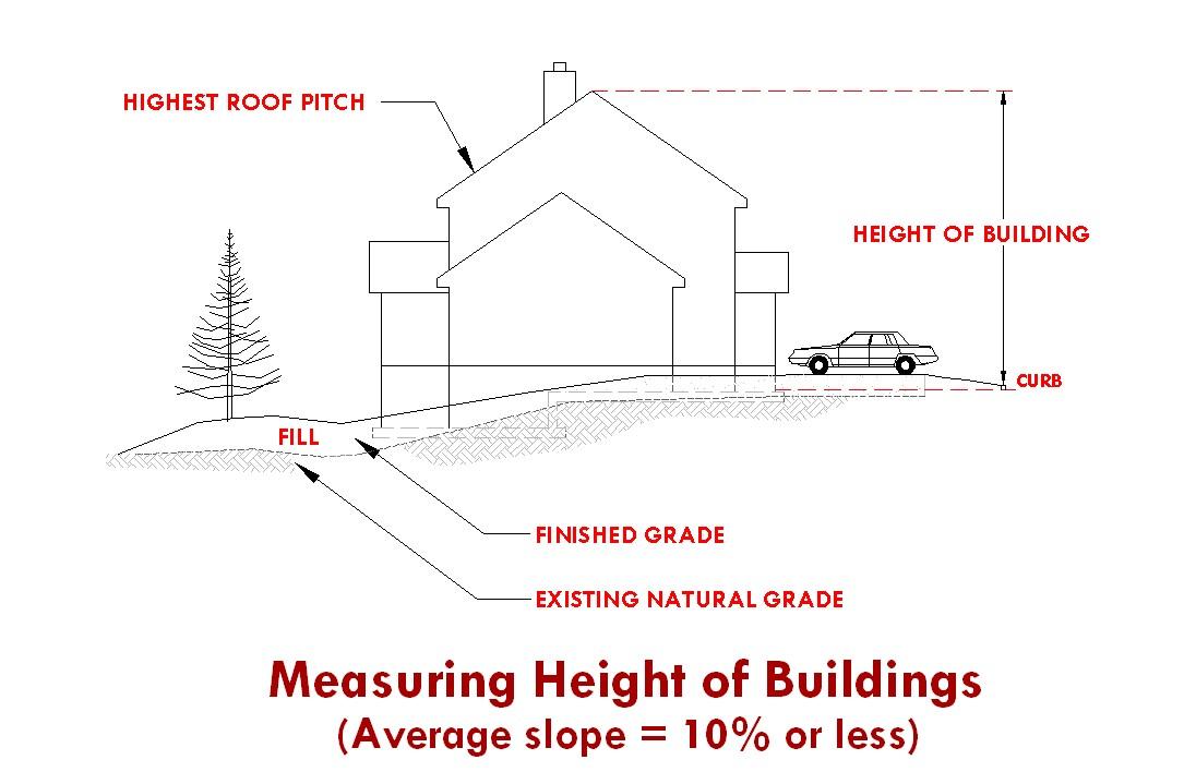
Height, Building. With natural grade of up toand including 10%, “height of a building” is the vertical distance measured between the elevation of the curb serving the property, and the highest point on the roof. For sites having a natural grade of greater than 10%, “height of a building” is measured from average finished grade to the highest point of the roof, and a maximum of 4 feet of introduced fillis permitted. See illustrations below.
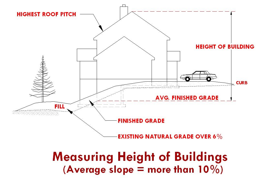
4’ fill (max.) permitted without a variance
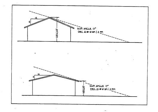
Highest Shade Producing Point. The highest shade producing point of the structure two hours before and after the solar zenith on December 21. The highest shade producing point could be thetallest point of the structure. Whenever the roof pitch is at an angle less than 17 degrees, the highest shade producing point will be the bottom eave of thestructure (see figure below).
Hive. Any Langstroth type structure withmovable frames intended for the housing of a bee colony. A hive typically consists of a cover, honey supers, brood chambers, and a bottom board.
HomeOccupation. Any business activity carried on by a resident, or resident family, of a dwelling as an accessory use withinthe same dwelling, or in an accessory structure onthe same property. The business activity shall not bedetrimental to the overallcharacter ofthe neighborhood.
Homeless Shelter. A building, facility, or portion thereof used by a not-for-profit agency or organization for the purpose of providing sleeping quarters.
Hospital. A facility withan organized medical staff, with permanent facilities that include inpatient beds and withmedical services, including physician services and continuous nursing services under the supervision of registered nurses, to provide diagnosis and medical or surgical treatment primarily for but not limited to acutely ill patients and accident victims, to provide treatment for the mentally ill or to provide treatment inspecial inpatient care facilities.
Hotel (Motel). Any building containing six or more guest rooms intended or designed to be used, or that are used, rented, or hired out to be occupied, or that are occupied for sleeping purposes by guests.
Impervious Surface. Any hard-surfaced area that does not readily absorb or retain water, including but not limited to building roofs, paved parking and driveway areas, sidewalks, and other paved areas.
Improvement. Any man-made physical addition to a property affecting the value or use of that property.
Improvement Agreement. Any contract, security or agreement that maybe required and accepted between the developer and the city toassure that necessary improvements will function as required for a specific period of time. See also Performance Guarantee
Indoor Commercial Recreation. A room or rooms within an enclosed building which is designated and used for recreational purposes by the public.
Infill Development. Development or redevelopment of vacant, parcelsof land in otherwise built-up areas.
Ingress. Access point for entering a building, site, or area.
Instrument Runway. Arunway equipped or to be equipped with a precision electronic navigation aid or landing aid or other air navigation facilities suitable to permit the landing of aircraft by an instrument approach under restricted visibility conditions. Instrument runways are classed as precision and non-precision instrument runways.
Intensity of Use. The range or scale or concentration or degree of impact of use, often measured by floor area ratios, building coverage or traffic generation.
Interest. Includes a lotor parcel, share, undivided interest, or membership which includes the right to occupy the landovernight, and a lessee's interest in land for morethan three years or less than three years if the interest may be renewed under the terms of the lease for atotal period morethan three years. Interest does not include any security interest under aland sales contract, trust deed or mortgage. Interest does not include divisions of land created by lien foreclosures or foreclosures of recorded contracts for the saleof real property.
Junkyard. Primary or accessory use of land for the storage, dismantling or selling of castoff or salvage material of any sort in other than the original form inwhich it wasmanufactured and/or assembled and not including reconditioned second-hand furniture or fixtures soldfrom within a walled building.
Kennel. A lot or buildings in which four or more dogs or cats, at least four months of age, are kept commercially for board, propagation, training, or sale.
Land Division. The subdividing or partitioning of land for any purpose intolots or parcels, or the creation of lots or parcels for the purpose of sale or lease.
Land Division, Expedited. A division of land as defined in ORS 197.360.
Land Division, Middle Housing. A partition or subdivision of a lot or parcel on which the development of middle housing is allowed.
Landscape. The act of improving the aesthetic appearance or ecosystem function of land by changing its contours, adding and maintaining ornamental features and plantings.
Landscaping Supply. Indoor or outdoor sales (wholesale or retail) of bulk items typically associated with landscaping, including (but not limited to) topsoil, mulch, gravel, river rock, fountains, pavers, and so forth.
Land Use. The main activity that occurs on a piece of land.
Live/Work Unit, New. Anew structure or use, which is being created tohave no more than two (2) dwelling units, as wellas abusiness component (more intensive than a licensed home occupation as defined inthis code).
Live/Work Unit, Modified. Any existing on-site building that is being changed into astructure for the purpose of having no more than two (2) dwelling units, as well as a business component (more intensive than a licensed home occupation as defined in this code).
Live/Work Unit, Existing. Any existing on-site building in which no more than two (2) dwelling units, as well as abusiness component (more intensive than a licensed home occupation as defined in this code), already exists.
Livestock. Horses, mules, donkeys, cattle, llamas, alpacas, sheep, goats, swine, domesticated fowl and any animal bred and maintained commercially or otherwise, within any type of enclosure.
Loading Area. An off-street space within a building or on the same lot with a building, for the temporary parking of a commercial vehicle or truck while loading or unloading merchandise or materials.
Lodge. See Club Lot. A lawfully created unit of land that is created by a subdivision of land. See also Lot of Record
Corner Lot. Alot abutting upon two or more streets other than alleys, at their intersection, or upon twoparts of the same street, such streets or parts of samestreet forming an interior angleof less than 135 degrees within the lot line.
Cul-de-sac Lot. A lotfronting the bulb of a cul-de-sac that has a frontage of less than 50 feet.
Double Frontage Lot. An interior lot having frontage on more than one street, or a corner lot having frontage on morethan two streets.
Flag Lot. Alot which fronts a public street or road and where access tothe street or road is by a privatedriveway. A lot shall be considered as a "flag lot" if the pole of the flag lot is less than half the width of the average lot width having between 20 and 50 feet of street frontage.
Interior Lot. Alot other than a corner lot.
Irregular Lot. Alot of such a shape or configuration that technically meets the area, frontage and width requirements of these standards but meets these requirements by incorporating unusual elongations, angles, curvilinear lines unrelated totopography or other natural land features.
Nonconforming Lot. A lot that lawfully existed prior tothe enactment of the requirements of these standards, butwhich does not meet theminimum lot size or lot width requirements.
Through Lot. An interiorlot having a frontage on two streets and/or highways, not including an alley.
See also Lot, Double Frontage
Lot Area. The total horizontal surface area within the property lines of alot, exclusive of streets. Lot Consolidation. The consolidation of lot lines resulting in fewer lots.
Lot Coverage. The percentage of a lot containing the footprint of structures or buildings.
Lot Line. The property line bounding a lot.
Front Lot Line. For a lot other than a corner lot, the lot line abutting a street other than an alley; for a corner lot, a lot line abutting either street other than an alley. In the case of acorner lot, or doublefrontage lot, the Community Development Department Director, or designee, shalldetermine the front lot line. The determination shallbe made to provide the necessary public safety and shall be based on street classifications, house and driveway orientation, lot dimensions, and adjacent property use.
Rear Lot Line. The lot line that is opposite andmost distant from the front lot line. In the case of an irregular, triangular or other shaped lot, a line ten (10) feet in length within the lot parallel to and at amaximum distance from the front lot line.
Side Lot Line. Any lot line or lines not afront or rear lot line. An interior side lot line is a lot line common tomorethan one lot or to the lot and an alley; and exterior side lot line is a lot line common tothe lot and a street other than an alley.
Lot Line Adjustment. The adjustment of common property line(s) or boundaries between adjacent lots, tracts, or parcels for the purpose of accommodating atransfer of land. The resulting adjustment shall not create any additional lots, tracts, or parcelsand all reconfigured lots, tracts, or parcels shall contain sufficient area and dimension to meetminimum requirements for zoning and building purposes.
Lot of Record. Any unitof land created as follows:
1. A lot in an existing, duly recorded subdivision;
2. A parcel in an existing, duly recorded major or minor land partition; or,
3. An existing unit of land for which a survey has been duly filed which conformed to allapplicable regulations at the time of filing; or
4. Any unit of land created by deed description or metes and bounds provided, however, contiguous units of land created by deed description or metes and bounds under the sameownership and not conforming tothe minimum parcel size of these standards shall be considered one (1) lot of record.
Lot Width. The horizontal distance between the side lines of a lot measured at right angles to its depth along a straight line parallel to the front lot line at the minimum required setback. Lumber Mill. Facility having the primary purpose of shaping and cutting raw or partially finished lumber.
Manufactured Dwelling Park. Any place where four or more manufactured dwellings or prefabricated structures, as defined in ORS455.010, that are relocatable and morethan eight and one-half feet wide, are located within 500 feet of one another on alot, tract or parcelof land under the same ownership, the primary purpose of which is to rent or lease space or keep space for rent or lease to any person for a chargeor fee paid or to be paidfor the rental or lease or use of facilities or to offer space free in connection with securing the trade or patronage of such person.
Manufacturing, Commercial. Light assembly as a support use to the primary commercial use (i.e., furniture assembly, electronic repair / assembly).
Manufacturing, Heavy Industrial. Industrially related manufacturing; typified by use of larger machinery or chemicals; not generally associatedwith commercial sales other than as a secondary use to the primary industrial use.
Manufacturing, Light Industrial. Fully enclosed; manufacturing of itemspermitted in the respective zone; does not use chemicals or materials which may be toxic or otherwise detectablevisually or by odor from neighboring properties.
Martial Arts Studio: Aplace where any art of self-defense is taught and/or practiced.
Master Development Plan (MDP). Adetailed development plan showing compliance with the applicable Great Neighborhood Planning Principles, the Redmond Urban Area Framework Plan, and adopted Area Plans on lands currently zoned Urban Holding-10 (UH-10). The MDP typically identifies proposed land uses, buildings locations, landscaping, potential art locations, access
and internal circulation, and infrastructure for a project where the development program may be planned to occur in phases over a period of several years. MDP’s may include multiple land parcels. The MDP is a required urban planning step before annexation and rezoning property.
Master Plan; Master Development Plan. An overall plan indicating the physical and functional interrelationships between uses andfacilities for a project, a series of projects or phased developments. Components of a master plan areset forth in RDC 8.0270.
Middle Housing. Means Duplexes, Triplexes, Quadplexes (fourplexes), Cottage Clusters, and Townhouses
Ministerial. Aroutine governmental action or decision that involves littleor no discretion. The issuance of a building permit is a ministerial action.
Mini Storage. Securable, “for rent” unit intended to store personal itemson a long-term basis. Mixed-Use. Development that combines residential, commercial, public, or institutional uses within the same building or site. Mixed-use development may occur as a “vertical” mixed-use, where housing is located above the ground floor, or “horizontal”mixed-use, where housing is located on the ground floor or in a separate building or part of abuilding.
Within horizontal mixed-use developments, residential uses shall be located behind commercial uses relative to the front lot line, or if located at the front of the building, be less than 20% of the frontage of such mixed-use building. Stand alone residential uses may be horizontally mixed with other uses as specified in the MUN zone.
Mobile Food Pod. A site containing more than one Mobile Food Unit andassociated amenities. Mobile Food Unit. A mobile vehicle, such as a food truck, trailer, or car, from which primarily food or beverages is provided to walk-up customers and does not include drive-thru service. Mobile Food Units shallbe mobile at all times and must be on wheels that are functional and appropriate for the typeof unit at all times.
Mobile Food Vendor. A Mobile Food Unit operating in a temporary manner in conjunction with a public or private event.
Modification. Amodification is an amendment to an approved site development plan, a condition of approval, or change to an existing structure that has not received a land use approval.
Minor Modification: A change that is less than 25% of any building footprint, height or size, site improvement or dimensional requirement.
Major Modification: A change that is equal toor greater than 25% of any building footprint, height or size,site improvement or dimensional requirement.
Floor Area: The sum total of the gross horizontal areas of each story of the building measured from the inside of exterior walls or from the centerline of the party walls.
Floor area ratio (FAR): The total floor area of allstructures and all above grade floors on a lot divided by the lot area. For FAR calculations, the floor area is measured to the inside of exterior walls. The following shall be excluded from the floor area calculation:
A. Space below grade
B. Mechanical spaces
C. Elevator and stair shafts
D. Lobbies and common spaces, including atriums
E. Space dedicated toparking
F. Decks, balconies, porches
Modification of Application. Means the applicant’s submittalof new information after an application has been deemed complete and prior to the close of the recordon a pending application that would modify a development proposal by changing one or more of the following previously described components: proposed uses, operating characteristics, intensity, scale, site lay out (including, but not limited to, changes in setbacks, access points, building design, size or orientation, parking, traffic, or pedestrian circulation plans), or landscaping in a manner that requires the application of newcriteria to the proposal or that would require the finding of
fact to be changed. It does not mean an applicant’s submission of new evidence that merely classifies or supports the pending application.
Monument. Apermanent and fixed survey marker conforming tothe requirements established by state law andthe regulations of Deschutes County.
Multi-family Complex. See Dwelling, Multi-family Complex.
MUTCD: Manual of Uniform Traffic ControlDevices, Federal Highway Administration. Needed Housing. As defined in ORS 197.303, as amended.
Net Square Footage. Gross square feet of a building less common areas and interior walls. Common areas include stairwells, elevators, storage areas, computer server rooms, other shafts, lobbies, underground parking, and similar kinds of uses.
Non-Conforming Structure or Use. Alawful existing structure or use at the time these Development Code standards or any amendment thereof becomes effective, which does not conform to the requirements of the zone in which it is located.
Nursery for Plants. Enclosed facility intended for commercially growing or distributing plants. Nursing Home. Any home, institution or other structuremaintained or operating for the nursing and care of four or moreillor infirm adults not requiring hospital care or hospital facilities.
Office. A room, suite of rooms, or portion of a building used for the practice of a profession or for conducting the affairs of a business.
Open Space. Land retained as undeveloped land for use as passive or active recreational area; land that is developed with park, landscaping, or other non-structural amenities. See also Usable Open Space
Overlay Zone. A defined area or district which provides regulations in addition to those regulations in the underlying zones.
Owner. Person in whom is vested the ownership, dominion, or title of property; includes contract purchaser.
Partial Master Development Plan (PMDP). A land use plan including the same requirements as a Master Development Plan (MDP) but for only a portion of the subject property(s). The PMDP is arequired urban planning step before annexation and rezoning property. Only the partially master planned portion of the property may be annexed unless otherwise approved by the City.
Partition. To divide an area or tract of land into two or three parcels.
Passive-Style Park. A park designed for passiverecreation that is of anyconfiguration, shape, or sizeand is landscaped without irrigated turf. Examples of passive-style park components include seating elements, shape structures or tree canopies, trails or walkways, habitat areas. See also Active-Style Park.
Passive Recreation. Recreational activities which are commonly unorganized, noncompetitive, dependent on the landscape, and requireno developed facilities. See also Active Recreation. Performance Bond. Adocument, acceptableby the city, issued by asurety company, inreturn for a fee or premium, guaranteeing the performance of the terms and conditions of a development approval.
Performance Guarantee. Any security or contract that may be accepted by a municipality as a guarantee that improvements required as part of an application for development are satisfactorily completed. See also Improvement Agreement.
Person. An individual, firm, partnership, corporation, company, association, syndicate, or any other legal entity, whether he, she or it is acting for himself, herself, or itself, or as the servant, employee, agent, or representative of another.
Plat, Final. The final plan of all or a portion of a subdivision or partition that is presented to the approving authority for final signature and recording in accordance with state law.
Plat,Tentative. A planof all or a portion of a subdivision or partition thatis submitted for approval in accordancewith state law, and that is not afinal plat.
Precision MachineShop. Shop or facility that manufactures alters or modifies metal parts. Typically applies to computerized machining of tools and parts requiring high precision machining.
Primary Use. The mostprevalent useto which property is or may be devoted, and to which all other uses onthe premises are derived as accessory or secondary uses. As used relative to dwelling units, the primary dwelling would be the first dwelling unit to be located on a specific parcel or lot.
Principal Use. The primary or predominant use to which the property is or may be devoted, and to which all other uses on the premises are accessory.
Printing and Publishing, Retail. Service commercial use providing printing services available to the general public.
Printing, Wholesale. Printing intended to serve retail or other wholesale uses rather thanthe general public.
Public Recreation Facility. A facility that is owned and operated by a public entity primarily for recreational uses. Accessory uses such as art studios, meeting/classrooms, child care, offices, and related commercial uses including food vendors and retail are allowed.
Public Right-of-Way. Astrip of land acquired by dedication, prescription or condemnation and intended to be occupied by a street, trail, waterline, sanitary sewer, and/or other public utilities or facilities.
Public Transportation Station. A place which includes a covered structure or a covered facility that is specifically designed to permit users toaccess public transit (such as buses). Such stations permit users to access one or more modes of public transit and incorporate public accommodations such as vehicle and bicycle parking, rest rooms, vending machines, benches, and tables for the convenience of travelers.
Public Use. A structureor property intended or used for a public property is or may be devoted, and to which all other uses on the premises are accessory.
Public Way. Any street, alley, or other parcel of land open to the outside air leading to a public street, which has been deeded, dedicated, or otherwise permanently appropriated tothe public for public use and that has a clear width and height of not less than 10 feet.
Quasi-Judicial Action. A decision or action of a public body that involves substantial discretion or judgment in applying the standards and criteria of this Code.
Recreational Area. Areas (other than village green) that are designed, constructed, designated, or used for recreational activities. Examples include: open space containing a park; landscaped or undisturbed natural areas; landscaped trails where a 10-foot-wide paved trail is in a 20 foot easement and is not a public sidewalk; pavilion areas at least 600 squarefeet in area; pool; splash pad; play court for racket sports and basketball; clubhouse; community room; art and seated viewing area; community garden; a plaza(s) at least 600 square feet in area.
Recreational Vehicle. A vehicle with or without motive power that is designed for use as temporary living quarters for recreational, camping, or travel use. Recreational vehicles include travel trailer, truck camper, and motor home.
Recreational Vehicle (RV) Park. A place where two or more recreational vehicles are located within 500 feet of one another on a lot, tract, or parcel of land under common ownership and having as its primary purpose temporary living quarters and the renting of space and related facilities for a charge or fee. Approved Safe Parking and Vehicle Camping site, per Chapter 5 of City Code, do not constitute an RV Park.
Recreational Vehicle Site. A plot of ground within a recreational vehicle park intended for the accommodation of a recreational vehicle or other camping unit on a temporary basis. The site may include individual use areas for picnic tables, fire pits, privateparking, and other private uses.
Recycling Collection Center. Center used as a collection point for household or other types of residential recycling.
Recycling Use. Alteration of amaterial or commodity for re-use. Includes, but is not limited to, recycling aluminum, glass, paper, and plastic. Replat. An amendment to arecorded plat.
Research and Development Facility, General. Establishment primarily engaged in industrial or scientific research including limited product testing; does not include medical research. Research and Development Facility, Medical. Medically related research; use of biohazardous chemicals subject to DEQ regulations.
Reserve Strip. "Reserve Strip" means a strip of land usually a minimum of one foot in width, reserved across the end of a street or alley terminating at the boundary of a subdivision, or a strip of land between a dedicated street of less than full width and adjacent acreage, in either case reserved or held for future street extension or widening.
Residential Facility. Aresidential care, residential training, or residential treatment facility, as those terms aredefined in ORS 443.400, licensed, or registered under ORS 443.400 to 443.460 or licensed under ORS 418.205 to 418.327 by the Department of Human Services that provides residential care alone or in conjunction with treatment or training or a combination thereof for six to fifteen individuals who need not be related. Staff persons required to meet licensing requirements shall not be counted inthe number of facility residents and need not be related to each other or to any resident of the residential facility. (ORS 197.660)
Residential Home. Aresidential treatment or training or an adult foster home licensed by or under the authority of the department, as defined in ORS 443.400, under ORS 443.400 to 443.825, aresidential facility registered under ORS 443.480 to 443.500, or an adult foster home licensed under ORS 443.705 to 443.825 that provides residential care alone or in conjunction with treatment or training or a combination thereof for five or fewer individuals who need not be related. Staff persons required to meet licensing requirements shallnot be counted inthe number of facility residents and need not be related to each other or to anyresident of the residential home. (ORS197.660)
Residential Use. Occupancy such as a human dwelling or lodging place. Retail, Bulky. Large retail items including furniture, cars, etc.
Retail, Medical Supply. Shop that specializes in goods and commodities relating to care and rehabilitation of medical patients.
Ridge Line (building). The top of aroof at its highest elevation.
Road. Apublic or private way that is created to provide ingress or egress for persons to one or more lots, parcels, areas, or tracts of land. See also Street.
Rock Crushing, Permanent. Use of facility or site to crush rock as an ongoing operation. Could involve imported or on-site rock and may involve transporting crushed rock toother sites.
Rock Crushing, Temporary. Use of asitetocrush rock on a temporary basis. Must involve on-site rock only but may involve transporting said crushed rock to an off-premises site.
Crushing shall be incidental toprimary use onthe site.
Roof Treatments. Anyadditions toa style of roof that breaks up a singlepitched roof. Examples of roof treatments are dormers, cupolas, and multi-pitched roofs.
School. A place for teaching, demonstration, or learning.
Screening. Materials used to conceal a featureor object from sight, such as fencing, walls, canopy, vegetation, or other barrier.
Semi-PublicUse. Astructure or use intended or used for a semi-public purpose by achurch, lodge, club, or any othernon-profit organization.
Setback. The distancebetween the vertical faceof a structure and a property line. See Yard.
Single Room Occupancy. A residential dwelling with no less than four but no more than six attached single room occupancy units and sanitary or food preparation facilities for shared use of the occupant(s). Seealso Single Room Occupancy Unit.
Single Room Occupancy Unit. Dwelling Area within a single room occupancy development which is independently rented and lockable and provides living and sleeping space for the exclusive use of the unit occupant(s). See also Single Room Occupancy Development.
SiteImprovement. Landscaping, paving for pedestrian and vehicle ways, outdoor lighting, recreational facilities, etc., added to asite.
Slope. The amount of deviation of a surface from the horizontal, usually expressed as a percentage or by degrees.
Start of Construction. The first placement of permanent construction of a structure(other than a manufactured home) on a site, such as the pouring of slabs or footingsor any work beyond the stage of excavation.
Story. The portion of abuilding included between the upper surface of any floor and the upper surface of the floor nextabove it, except the top story shallbe that portion of abuilding within the upper surface of the top-most floor and ceiling or roof above.
Street. A public or private way, other than an alley, that is created to provide primary vehicle access for persons to one or more lots, parcels, areas, or tracts of land. See also Road.
Arterial Street (Major). Astreet with access control, channelized intersections, restricted parking, and that collects and distributes traffic to and from minor arterial streets.
Arterial Street (Minor). Astreet with ahigh volume of traffic that collects and distributes traffic to and from collector streets.
Collector Street. Arestricted access street supplementary to the arterial street system used or intended tobe used principally for the movement of traffic between arterial and local streets.
Cul-de-sac. Astreet having one end open totraffic and the other end terminating in a vehicle turnaround.
Dead End Street. A street having only one end open totraffic, and the other end terminating in a “stub out”.
Frontage Road. Astreet parallel and adjacenttoa collector or arterial providing access to abutting properties.
Local Street. Astreet intended primarily for access to abutting properties.
Roadway. That portion of a street developed for vehicular traffic.
Structure. Anycombinationofmaterialsforminganyconstruction,whichrequiresafoundation andis intendedtosupportorshelteranyuseof occupancy. Alsoseedefinitionof Accessory Structure.
Structural Alteration. Any change to the supporting members of a structure including foundation, bearing walls or partitions, columns, beams, girders, or any structural change in the roof or in the exterior walls.
Subdivide Land. Todivide land into four or more lots within a calendar year.
Subdivision and Subdivided Lands. Please refer to ORS92.010(16).
Subdivider. Any person who causes land to be subdivided.
Supportive Shelter. Any tract of land being actively managed by an agency which maintains two or more shelter units for the primary purpose of providing shelter alongside supportive services to individuals or families who lack access to permanent or safe shelter.
Thrift Store. Retail use that vends second-hand(used) items including clothing and furniture.
Townhouse. A dwelling unit that is part of arow of two or more attached dwelling units, where each dwelling unit is located on an individual Lot of Parcel and shares at least one common wall with an adjacent unit.
Townhouse Project. One or more townhousestructures constructed, or proposed to be constructed, together with the development site where the land has been divided, or is proposed to be divided, to reflect the Townhouse property lines and the any commonly owned property.
Tract, Private / Public. A piece of land set aside in a separate area for dedication to the public, a homeowner’s association, to other entity (e.g., open space, recreation facilities, sensitive lands, etc.).
Truck Stop. Fueling facility that also provides food, washing facility andother amenities whose primary clientele is semi-truck drivers and rigs.
Turf. Vegetated groundcover, typically aspecies of grass.
Artificial Turf. Synthetic Fiber surfacing made to mimic the appearance orfunction of grass or other groundcover without the requirements of real plant material.
Irrigated/Irrigatable Turf. Vegetated groundcover, typically grass or sod, requiring active management and inputsto maintain, including but not limited to the installation/use of irrigation infrastructure, fertilizers, pesticides, ect.
Native/Natural Turf. Vegetative groundcover consisting of native plants species, needing no management or inputs to maintain.
UnbuildableArea. An area in which a structure could not be built as a permitted use under existing development standards for the area according to the Redmond Development Code. Urban – Rural Interface. The area where urban development interfaceswith Deschutes County zoned rural areas.
Usable Open Space. Areas that contain natural or man-made vegetation that are physically accessible year-round for use by the general public, or by specific groups or persons within a defined project boundary or physical area (such as within a Planned UnitDevelopment). Water surfaces such as ponds or canals; canyon walls, and other areas that arenot physically accessible year-round to the general public are not to be counted as part of the required “usable open space area”.
Use. The purpose to which land and/or any structure or improvement thereon is or is proposed to be put. The word "use" is synonymous withthe terms "land use" and "use of land" unless the context clearly indicates otherwise.
Utilities. Public or private infrastructure which includes but is not limited tosewer, water, electric, telephone, natural gas, and cabletelevision.
Utility Facility. Any major structure owned or operated by a public, private or cooperative electric, fuel, communication, sewage or water company for the generation, transmission, distribution or processing its products or for the disposal of cooling water,waste, or by-products, and including power transmission lines, major trunk pipelines, power substations, dams, water towers, sewage lagoons, sanitary landfills and similar facilities, but excluding sewer, water, gas, telephone and power local distribution lines and similar minor facilities allowed in any zone.
Vehicle Storage and Towing Yard. Lot for storage of parking tow-a-way’s, impound yard, and storage lot for autos, trucks, busses, and R.V.’s.
Veterinary Clinic. Afacility in which medical care is provided to animals.
Warehouse. Storage space for household or commercial goods withinan enclosed building without direct access toindividual storage spaces. Excludes wholesale distribution and storage, and vehicular storage.
Wholesale Distribution. An establishment engaged in the bulk sales or storage of goods with distribution and storage facilities without direct public access. Includes “contractor supplies”.
Workforce Housing. Housing that constitutes nomorethan 30 percent of such gross annual household income for a family earning 80 to 120percent of the Area Median Income (AMI). AMI is based on the most recent HUD Income Limits for the Bend-Redmond Metropolitan Statistical Area. Workforce Housing warrants income-based deed restrictions of at least 30 years. The affordability period maybe adjusted based on the use of development incentives, modifications, variances, or exceptions.
Yard. An open space on a lot which is unobstructed from the ground up, except as otherwise provided in these standards. Yards provide light,ventilation, privacy, room for drainage, landscaping, and emergency access.
Yard, Front. A yard between side lot lines andmeasured horizontally at right angles tothe front lot line from the front lot line to the nearest point of a building. Any yardmeeting this definition and abutting on astreet other than an alley shallbe considered a front yard.
Yard, Rear. Ayard between side lot lines and measured horizontally at right angles to the rear lot line from the rear lot line to the nearest point of a building.
Yard, Side. Ayard between side lot lines and measured horizontally at right angles from the side lot line to the nearest point of a building.
Zero LotLine. The location of a building on a lotin such a manner that one or more of the building’s sides rest directly on a lot line.
Zero LotLineSubdivision. Atype of subdivision utilizing zero lot lines between units and providing for potential individual ownership of each lot.
[Section 8.0020 amended by Ord. #2009-04 passed April 28, 2009]
[Section 8.0020 amended by Ord. #2009-03 passed May 26, 2009]
[Section 8.0020 amended by Ord. #2009-14 passed December 8, 2009]
[Section 8.0020 amended by Ord. #2010-10 passed October 26, 2010]
[Section 8.0020 amended by Ord. #2011-09 passed November 8, 2011]
[Section 8.0020 amended by Ord. #2012-04 passed April 24, 2012]
[Section 8.0020 amended by Ord. #2012-10 passed August 14, 2012]
[Section 8.0020 amended by Ord. #2015-01 passed February 24, 2015]
[Section 8.0020 amended by Ord. #2016-17 passed January 31, 2017]
[Section 8.0020 amended by Ord. #2018-09 passed September 11, 2018]
[Section 8.0020 amended by Ord. #2020-15 passed November 10, 2020]
[Section 8.0020 amended by Ord. #2022-04 passed June 28, 2022]
[Section 8.0020 amended by Ord. #2022-09 passed December 13, 2022]
[Section 8.0020 amended by Ord. #2023-07 passed December 19, 2023]
8.0025Compliancewith Zoning Provisions.
1. A lot may be used, and a structure or part of a structure may be constructed, reconstructed, altered, occupied, or used only asthese standards permit.
2. No dimensional requirement of these standards shall be violated after its terms become effective unless specifically provided for herein.
3. No lot area, yard, or other open space which is required by these standards for one use shall be used as the required lot area, yard, or open space for another use.
[Section 8.0025 amended by Ord. #2020-15 passed November 10, 2020]
8.0026Consistency with Plans and Laws. Actions initiated under this Code shall be consistent with applicable state and federal laws and regulations as these laws and regulations may now or hereafter provide. No parcel of land or structure may be used for, or in conjunction with, an activitythat violates any state or federal law.
[Section 8.0026 added by Ord. #2014-03 passedApril 1, 2014]
8.0030Authority and Land Use or Zoning Approval.
1. Authority. Whenever necessary to enforce the provisions of the Development Code, the Director, or designee, shall have the authority in addition to other remedies provided by law, to issue compliance notices and orders, assess penalties, record violations and liens with the City Clerk, issue citations, to institute injunction, mandamus, abatement, or
other appropriate proceedings to prevent, temporarily or permanently enjoin or abate a violation.
2. Approval. The Direction, or designee, or other Approving Authority, shall not give land use or zoning approval on any development or use of land that is not in full compliance with all applicable provisions of the Development Code, regardless of whether the applicant(s) or current owner(s) created the violation.
3. Prior to the construction, alteration or change of use of any structure or lot for which land use approval or a zoning permit, but not a building permit, is required, approval for such construction, reconstruction, alteration, or change of use of any structure or lot shall be obtained from the Planning Department. Approvalmay be authorized if:
A. It results in the property coming into full compliance with all applicable provisions of the Development Code or City Code. This includes sequencing of permits or other approvals as part of a voluntary compliance agreements.
B. It is necessary to protect public safety and welfare.
C. It is for work related to and within a valid easement over, on or under an affected priority.
[Section 8.0030 amended by Ord. #2022-04 passed June 28, 2022]
8.0035Abrogation and Greater Restrictions. It is not intended by these standards to repeal, abrogate, or impair any existing easements, covenants, or deed restrictions.
8.0040Interpretation. Where the conditions imposed by any provision of these standards are less restrictive than comparable conditions imposed by any other provisions of these standards or by any ordinance, resolution, or regulation, the provisions which are more restrictive shall govern.
8.0045Repeal of Standards as Affecting Existing Liabilities. The repeal of any zoning standard contained herein shall not have the effect to release or extinguish any penalty, forfeiture, or liability incurred under such zoning standards, unless a provision of these standards shall so expressly provide, and such provisions repealed shall be treated as still remaining in force for the purpose of sustaining any proper action or prosecution for the enforcement of such penalty, forfeiture, or liability, and for the purpose of authorizing the accusation, prosecution, conviction, and punishment of a person or persons who violated the repealed provisions or part thereof prior to the effective date of these standards.
8.0050Existing Agreement and Zoning Permits. This does not repeal, abrogate, or impair any existing easements, covenants, deed restrictions, zoning permits such as preliminary plat and partition approvals, conditional use permits, non-conforming use permits, temporary use permits, special exceptions, for building permits.
8.0055Site Plan Review.
1. No building, grading, parking, land use, sign or other required permit shall be issued for a use for which a site plan is required by the Redmond Site and Design Review Standards until such time those requirements are met.
2. Non-compliance with a final approved site plan pursuant hereto shall be a zoning standards violation.
8.0060Authorization of Similar Uses and/or Waivers. The Community Development Director, Designee, or Planning Commission may determine that a use or site element not specifically listed in the allowed uses of a zone shall be included among the allowed uses; this determination shall be made by administrative process. A similar use determination shall be decided based on the following criteria:
1. The use or element is similar in character to one or more of the principal uses permitted; 2. The traffic generated on such use is similar to one or more of the principal permitted uses;
3. The use is not first permitted in a less restrictive zoning district; and 4. The use is consistent with the comprehensive plan. Conditions of approval may be required to assure the proposed use is consistent with the purpose of the applicable zone and comprehensive plan.
[Section 8.0060 amended by Ord. #2016-17 passed January 31, 2017]
8.0065Establishment of Zones and Districts. (Identifies allowable zones and definitions for them):
R-1 Limited Residential Zone. To provide lower density residential neighborhoods for single family detached residences, middle housing, and a mix of other housing types.
R-2 Limited Residential Zone. To provide low density residential neighborhoods for single family detached residences, middle housing, and a mix of other housing types.
R-3 Limited Residential Zone. To provide medium density residential neighborhoods with a mix of single-family detached residences, middle housing, and a mix of other housing types.
R-3A Limited Residential Zone. To provide medium density residential neighborhoods with a mix of single-family detached residences, middle housing, mix of other housing types, and allow for some limited commercial use on a conditional use basis. Examples of limited commercial uses include restaurant, theater, art gallery, office space and retail.
R-4 General Residential Zone. To provide medium density residential neighborhoods with a mix of single-family detached residences, middle housing, and a mix of other housing types including multi-family residential development. Limited commercial uses such as offices are also conditionally permitted where compatible with surrounding development.
R-5 High Density Residential Zone. To provide high density residential neighborhoods with an emphasis on multi-family development, middle housing, and smaller lot single family developments. Limited commercial uses such as offices are also conditionally permitted where compatible with surrounding development.
UH-10 Urban Holding Zone. To retain large undeveloped or underdeveloped land areas for future urban development; to act as a holding category and is considered agricultural in nature as it will allow agricultural uses to continue operation until urbanization takes place. Land in the UH-10 Holding Zone requires annexation, master plan approval, a zone change and/or a comprehensive plan amendment before urban development can occur. In most instances, Master plans are required before development can occur.
C-1 Strip Service Commercial Zone. To create and preserve areas suitable for commercial uses and services primarily oriented to automobile traffic, requiring extensive outdoor display and storage, and support of the central business district or principal downtown shopping area. In general, this zone shall be applied to those areas already existing and desirable to retain and for those areas that, because of new and/or
changing traffic patterns, should be developed for such purpose. In addition, this zone allows for high density residential development in these areas where such development will not adversely affect commercial development in the zone as a whole.
C-2 Central Business District Commercial Zone. To create and preserve areas suitable for commercial uses and services on a broad basis to serve as the central shopping or principal downtown area for the City. In general, this zone shall be applied to the town"center" already existing and desirable to retain, and to abutting and adjacent areas necessary to serve population growth. In any event, no other C-2 Zone shall be established until there is demonstrated need for such action; no two C-2 Zones shall be established in such relationship to each other that they cannot act as one center.
Downtown Overlay District. To create and preserve areas within the C-2 Central Business District Commercial Zone that is vibrant and pedestrian-friendly where people can shop, work, and play in a traditional downtown setting. In general, this district will encourage a vibrant mix of pedestrian-oriented uses, including residential, shopping and entertainment uses and increase in the density and intensity of development.
C-3 Special Service Commercial Zone. To create and preserve areas suitable for special commercial uses and services and compatible non-commercial uses, and on a broad basis to serve as a center for emergency services such as medical-health care for the City. The zone should also encourage the location of uses which provide close and easy access for that sector of the population which is in most need of such services such as the elderly and maintain the quiet and low intensity use atmosphere deemed preferential for such uses.
C-4 Limited Service Commercial Zone. To retain the general character of the limited strip type commercial that presently exists in that area encompassed by this zone, and to provide for a lower intensity of heavily auto-related business while maintaining an attractive appearance in the area of the western entry to the City; such entry being a high use route for visitors to the area.
C-4A Limited Service Commercial Zone. Limited strip type commercial and to provide for a lower intensity of heavily auto-related business. A mix of limited service commercial and limited residential uses are intended to serve large industrial tracts/employment areas and reduce crosstown vehicular trips.
C-5 Tourist Commercial Zone. To provide for commercial uses primarily oriented to travelers and tourists in locations complimentary to existing facilities and future major transportation facilities and to provide incentive for public and private investments in traveler and tourist related complexes.
M-1 Light Industrial Zone. To provide for light industrial uses such as light manufacturing, research, transportation facilities and similar uses which have a limited impact on surrounding properties and are compatible with clean non-polluting industries along with limited office and commercial activities which support these light industrial uses. Furthermore, uses associated with the M-1.5 General Industrial Zone can possibly be permitted.
M-1.5 General Industrial Zone. To provide for general industrial needs such as defined offices, industrial park activities, manufacturing, research, and contractor uses using less than 35% of the property for outdoor storage of raw or assembled materials. Development, site design and architecture should promote quality, compatibility, and aesthetics. Storage must be sufficiently screened by fences or landscaping. M-1.5 uses can be approved in either the M-1 Light Industrial Zone or M-2 Heavy Industrial Zone when approved through a Conditional Use Permit.
M-2 Heavy Industrial Zone. To promote the economic diversification by allowing a wide range of industrial and heavy commercial uses and providing sufficient land for industries that have a more pronounced impact on the urban environment because of
noise, smoke, air, and other emissions or because of traffic and other operating characteristics associated with these industries. The M-2 zone also allows for heavy commercial uses in areas where previous subdivisions of land and current ownership patterns have resulted in separate ownerships of smaller M-2 zoned parcels and, therefore, challenged to be readily used for industrial purposes. Furthermore, uses associated with the M-2Heavy Industrial Zone can possibly be permitted.
FG Fairgrounds Zone. To allow for development or enhancement of the Deschutes County Fairgrounds to support services, facilities, or events to serve the region (e.g., related to training, sporting, recreational, medical, conference, public safety, or emergency coordination).
(LLI) Large Lot Industrial Zone. That area within the City identified to attract, aid, or facilitate industrial and business development projects focused on, in support of, or that directly benefit traded-sector uses that require an adequate supply of large, developable parcels of industrial land for industrial uses, including distribution centers and warehouse centers.
OSPR Open Space Park Reserve Zone. To preserve and provide for open space areas of natural, scenic, historical, or geological significance and to provide areas for recreational development and use, both passive and active. The OSPR zone also provides for private development appropriate with the goals and master plan for the canyon and the transfer of development rights to areas suitable for higher density development.
Airport Control (AC) Overlay Zone. In order to provide for the safety and use of land coincident with the Redmond Municipal Airport and prevent man-made or natural objects from encroaching into necessary aviation airspace, certain airport control zones are created which include all of the land lying within transitional surfaces, conical surface, instrument approach surface, non-instrument approach surfaces and horizontal surface. These zones are established as indicated on the current Redmond Airport Master Plan (Airport Layout Plan drawing set) for existing runways and future modifications thereto, Redmond Municipal Airport, or any other airport that may be constructed necessitating aviation controls which will affect land within the corporate limits of Redmond.
Airport Zone / Airport Compatibility Zone. To provide, encourage and support the continued operation and vitality of Redmond Municipal Airport by allowing certain airport related light industrial, manufacturing, commercial or recreational uses in accordance with state law (ORS 8.36.600 et seq.).
PF Public Facilities Zone. To provide for public facility and other uses such as: wastewater treatment facilities, water storage reservoirs, well sites, public schools, public or private child care facilities, transportation/mobility, libraries, museums, pavilions, public plazas, public safety or emergency services, emergency training and coordination facilities, and Public Works Administration facilities.
Park Zone. To provide for public park uses such as playgrounds, ball fields and open space.
MUE Mixed-Use Employment Zone. The purposes of this zone are to:
1. Areas designated MUE are intended for development as employment centers developed as campus-type or light industrial with some limited commercial and residential development contained within the MUE area. Stand alone residential projects are not permitted within the MUE area. The City may provide for mixed use projects located within the MUE through planned developments.
2. Commercial uses must be of a type and scale that is designed to support surrounding industrial, and employment uses and may not be used for commercial development that serves a regional retail function, such as large merchandise retailers, home improvement centers, and mini-mall developments.
3. Development within the district should be oriented to pedestrians and support non-motorized and mass transportation modes.
MUN Mixed-Use Neighborhood Zone. The minimum size for this zoning district is 3 acres. The purposes of this zone are to:
1. Establish an area in which a critical mass of retail, service, and other commercial uses together with civic uses can be located which can provide everyday goods and services to residents of the surrounding neighborhoods. Residential uses may be combined with commercial uses (as horizontal or vertical mixed-uses or live/work units) or may be allowed as standalone uses when developed as multi-family housing subject to siteand design standards.
2. Encourage development that exhibits the physical design characteristics of pedestrian-oriented, storefront-style shopping streets; and
3. Promote the health and well-being of residents by encouraging physical activity, alternative transportation, and greater social interaction.
MULW Mixed Use Live/Work Zone. The purpose of the MULW zone is to:
1. Provide a mixed-use area that is appropriate for development which may include both living unitsand work space;
2. Provide flexibility for the development of live/work units; and,
3. Provide locations, where appropriate, for new businesses to start up and existing businesses to continue and potentially expand.
[Section 8.0065 amended by Ord. #2009-03 passed May 26, 2009]
[Section 8.0065 amended by Ord. #2009-14 passed December 8, 2009]
[Section 8.0065 amended by Ord. #2011-09 passed November 8, 2011]
[Section 8.0065 amended by Ord. #2015-01 passed February 24, 2015]
[Section 8.0065 amended by Ord. #2016-17 passed January 31, 2017]
[Section 8.0065 amended by Ord. #2017-12 passed December 12, 2017]
[Section 8.0065 amended by Ord. #2020-15 passed November 10, 2020]
[Section 8.0065 amended by Ord. #2022-04 passed June 28, 2022]
[Section 8.0065 amended by Ord. #2022-09 passed December 13, 2022]
[Section 8.0065 amended by Ord. #2023-07 passed December 19, 2023]
8.0070Location of Zones. The boundaries of the zones listed in these standards shall be as indicated on the most recent City of Redmond Zone Map, as amended, which is hereby adopted by reference. The boundaries shall be modified in accordance with Section
8.0750 et seq (Amendments).
[Section 8.0070 amended by Ord. #2022-04 passed June 28, 2022]
8.0075Zoning Maps. A Zoning Map or Zoning Map Amendment adopted by Section 8.0070 of these standards or by an amendment to said section shall be prepared by authority of the Planning Commission or be a modification by the City Council of a map or map amendment so prepared. The map or map amendment shall be dated with the effective date of adoption of the map or map amendment. A certified print of the adopted map or map amendment shall be maintained in the office of the County Clerk, the office of the City Manager and the Planning Department as long as these standards remain in effect.
8.0080Zone Boundaries. Unless otherwise specified, Zone Boundaries are section lines, subdivision lines, lot lines, center lines of streets, alleys, canal, or rights-of-way, water courses, ridges or rimrocks, other readily recognizable or identifiable natural features, or such lines extended. Whenever any uncertainty exists as to the boundary of a zone as shown on the Zoning Map or amendment thereto, the following regulations shall control:
1. Where a boundary line is indicated as following a street, alley, canal, or right-of-way, it shall be construed as following the center line of such right-of-way.
2. Where a boundary line follows or approximately coincides with a section, lot, or property ownership line, it shall be construed as following such line.
3. When a lot is divided by a zone boundary and the property owner disputes the location of the boundary, the owner may file a declaratory ruling to determine the exact location of the zone boundary. In this case, the determination shall be made by the Hearings Body, subject to appeal by the City Council.
4. Where a public street, alley, canal, or railroad right-of-way is officially vacated, the zoning regulations applicable to abutting property on each side of the center line of such right-of-way is officially vacated, the zoning regulations applicable to abutting property on each side of the center line of such right-of-way on each respective side thereof. If the right-of-way is vacated intotal to one property owner, the zoning of that abutting property shall apply to the total vacated property.
[Section 8.0080 amended by Ord. #2022-09 passed December 13, 2022]
8.0085Zoning of Annexed Areas. Property annexed to the city shall be zoned in compliance with approved Urban Area Master Plans or with a zoning classification that is compatible with planned land use designations in the Comprehensive Plan, the Redmond Urban Area Framework Plan, as determined by the City.
[Section 8.0085 amended by Ord. #2015-01 passed February 24, 2015]
RESIDENTIAL USE ZONES
8.0100 Limited Residential R-1 Zone.
8.0105 Limited Residential R-2 Zone.
8.0110 Limited Residential R-3 Zone.
8.0111 Limited Residential R-3A Zone.
8.0115 General Residential R-4 Zone.
8.0120 High Density Residential R-5 Zone.
[Section 8.0121 deleted by Ord. #2023-07 passed December 19, 2023]
[Section 8.0125 deleted by Ord. #2022-04 passed June 28, 2022]
[Section 8.0125 deleted by Ord. #2023-07 passed December 19, 2023]
8.0130Urban Holding UH-10 Zone. The City shall administer the provisions of Title 20 Redmond Urban Area Zoning Ordinance of the Deschutes County Code for this County zoning district.
1. Master Development Plans. The development and approval of an Urban Area Master Plan subject to the provisions of RDC 8.0270 is required as a condition of annexation, prior to or concurrent with rezoning from UH-10 to City zoning districts.
2. Exception to Master Development Plans Requirement. Approval of a development plan may be granted without going through a Master Development Plan process according to the following requirements:
Non-Residential Properties.
A. The development plan is 12 acres or less in size; and,
B. The development plan addresses the applicable Great Neighborhood Principles; and, the development plan includes an appropriate local grid street plan, that complies with street spacing and connectivity requirements in the Redmond TSP and showing street connectivity and bike/pedestrian system connectivity to adjacent planned and unplanned residential areas; and,
C. The development plan meets applicable requirements for land near the urban edge; and,
D. The development approval is obtained through a PUD process except when the property is to be used for a public use, such as for a park or school or some other public facility; and,
E. Annexation to the City of Redmond is proposed as part of the development plan; and,
F. The development plan addresses all other applicable requirements of the Redmond Comprehensive Plan and Development Code; and,
G. The development plan conforms to the density and design guidelines established for the area in the Redmond Urban Framework Plan and/or an adopted Area Plan.
Residential Properties.
H. The parcel is within theCity of Redmond or canbe annexed to the City; and,
I. The parcel is 3 acres or less in size; and,
J. The development plan conforms to the density and design guidelines established for the area in the Redmond Urban Framework Plan and/or an adopted Area Plan; and,
CHAPTER 8 DEVELOPMENT
K. The development plan meets the applicable Great Neighborhood Principles, Land Division, and SitePlan policies; and,
L. Significant Goal 5 resources, as defined in Redmond Comprehensive Plan, Chapter 5, are identified, and managed, in accordance with Redmond’s Goal 5 resourceprotection program; and,
M. The development plan includes an appropriate local grid street plan that complies with street spacing and connectivity requirements in the Redmond TSP and showing street connectivity and bike/pedestrian system connectivity to adjacent planned and unplanned residential areas; and,
N. The development plan meets applicable requirements for land near the urban edge and meets applicable planning requirements for land near the urban rural interface; and,
O. The development application meets all other required elements for one of the City’s land use planning approval processes.
[Section 8.0130 amended by Ord. #2015-01 passed February 24, 2015]
[Section 8.0130 amended by Ord. #2020-15 passed November 10, 2020]
[Section 8.0130 amended by Ord. #2022-04 passed June 28, 2022]
CHAPTER 8 DEVELOPMENT REGULATIONS
8.0135Table A, Residential Zones, Uses Permitted. The following uses are allowed outright or conditionally in each of the Residential zones as follows:
“O” means Permitted Outright
“C”means Permitted Conditionally
“N”means Not Allowed
AccessoryBuilding: Detachedsheds,shops,andgarages
Mustbelocatedwithinthepropertyandnotintheyard setbackareas.Moveableshippingcontainers,orsimilar, arenotallowed. GuestHouse
AccessoryDwellingUnit/Accessory Suite
AccessoryUse
Apartments
Nokitchen;usesmainhouses'sewer&water
Usesmainhouses'sewer&waterorindividualCity Services;mayhavekitchen
IncludesHomeOccupations
SeeMulti-FamilyComplex/Dwelling
Subjecttocompliancew/applicableORS
CHAPTER 8 DEVELOPMENT REGULATIONS
MobileFoodVendoronprivateproperty
MobileFoodVendoronpublicproperty
ReviewedunderORS197.782.Emergencysheltersfor naturaldisasterresponsearenotsubjecttoreview.
PermittedthroughBusinessLicensingprovisionsinCity Code,Section7.005etseq.Canonlyoperatebetween8 AMand9PMfornomorethantwoconsecutivedays withina90-dayperiodandmustbelocatedonreal propertyinassociationwithanevent.
PermittedthroughSpecialEventsprovisionsinCity Code,Section7.350etseq.orParksReservation Permit.
Subjecttolivestockprovisions,section8.0365
ConditionalinconjunctionwithamasterplanorPUD
ConditionalinconjunctionwithamasterplanorPUD
All"R"zonesaresubjecttodensitytransferprovisions.See8.0020,"Definitions," Density Transfer, and8.0367,"OSPR/'R'ZoneDensity TransferProvision
[Section 8.0135 amended by Ord. #2009-04 passed April 28, 2009]
[Section 8.0135 amended by Ord. #2015-04 passed May 19, 2015]
[Section 8.0135 amended by Ord. #2016-17 passed January 31, 2017]
[Section 8.0135 amended by Ord. #2018-09 passed September 11, 2018]
[Section 8.0135 amended by Ord. #2020-15 passed November 10, 2020]
[Section 8.0135 amended by Ord. #2022-04 passed June 28, 2022]
[Section 8.0135 amended by Ord. #2023-07 passed December 19, 2023]
8.0137Table for R-3A Zones, Uses Permitted. The following uses are allowed outright or conditionally in the Residential Zone R-3A as follows:
CHAPTER 8 DEVELOPMENT REGULATIONS
AccessoryBuilding:Detachedsheds,shops, garages.
GuestHousesorAccessoryDwellingUnit
AccessoryUse
SingleFamilyDetachedDwelling,Duplex,Triplex, Quadplex,Townhouse,CottageCluster,Single RoomOccupancyDevelopment
Public-OwnedAffordableHousingDevelopment
Mustbelocatedwithinthepropertyandnot intheyardsetbackareas.Moveable shippingcontainers,orsimilar,arenot allowed.Pottingsheds,orsimilar,mustbe locatedwithinthepropertyandnotinthe yardsetbackareas.
Connectedtoprimaryresidentialunit utilities;includeskitchen.
IncludesHomeOccupation.
SeeSection8.0145 ResidentialCareHome
DefinedandregulatedbyORS.
MobileFoodVendoronprivateproperty
OnlywithinbuildingsexistingasofOct.20, 2007,orasmodified(expanded)uptoa maximumof25%.Anymodificationshall requiresiteplanreview.Abuilding destroyedordamagedmayberebuiltupto theformersizeandgeneralconfiguration.
MobileFoodVendoronpublicproperty
SupportiveShelter
PermittedthroughBusinessLicensing provisionsinCityCode,Section7.005et. Seq. Canonlyoperatebetween8AMand9PM fornomorethantwoconsecutivedays withina90-dayperiodandmustbelocated onrealpropertyinassociationwithan event.
PermittedthroughSpecialEvents provisionsinCityCode,Section7.350et. Seq.orParksReservationPermit.
SeeSection8.0370,SupportiveShelter Standards.
CHAPTER 8 DEVELOPMENT REGULATIONS
TennisCourt(private)
CityOwnedUtilityFacility
PrivateUtilityFacilities
ResidentialConversionofExistingCommercial Structure
EmergencyShelter
C = conditional uses.
SeeSection8.0144
O ReviewedunderORS197.78.2Emergency sheltersfornaturaldisasterresponseare notsubjecttoreview.
[Section 8.0137 amended by Ord. #2018-09 passed September 11, 2018]
[Section 8.0137 amended by Ord. #2020-15 passed November 10, 2020] [Section 8.0137 amended by Ord. #2022-04 passed June 28, 2022]
[Section 8.0137 amended by Ord. #2023-07 passed December 19, 2023]
8.0138Standards. Except as provided for in Section 8.0137 and 8.0615, the standards and criteriafor development in the R-3 zone shall apply to development in theR-3A zone.
8.0140Table B, Minimum Standards. The following minimum standards apply in each of the Residential zones:
CHAPTER 8 DEVELOPMENT REGULATIONS
Interiorsideyardsmustbeaminimumof5feetononesideand10feetontheothersideforsinglefamily,duplex, triplex,andquadplexresidences.Wherealleyaccessisprovided,bothinteriorsideyardsmaybereducedto5feet. Exceptionstothe10-footsetbackareallowed(1)whentheresidentiallotwascreatedpriortotheadoptionofthis standard(November9,2006);(2)oncul-de-saclots;or(3)onflaglots.
Setbacks:
ADUs:SpecifiedinSection8.0325
DetachedAccessoryStructures:SpecifiedinSection8.0323
CottageClusters:SpecifiedinSection8.0143
Multi-familyComplexes:SpecifiedinSection8.3035.4E.TableA.
Townhouses:SpecifiedinSection8.0142
[Section 8.0140 amended by Ord. #2012-04 passed April 24, 2012]
[Section 8.0140 amended by Ord. #2013-04 passed May 14, 2013]
[Section 8.0140 amended by Ord. #2018-09 passed September 11, 2018]
[Section 8.0140 amended by Ord. #2020-15 passed November 10, 2020
[Section 8.0140 amended by Ord. #2022-04 passed June 28, 2022]
[Section 8.0140 amended by Ord. #2022-09 passed December 13, 2022]
[Section 8.0140 amended by Ord. #2023-07 passed December 19, 2023]
8.0141Single Family Detached Dwellings and Plexes Development and Design Standards.
1. Purpose. The purpose of these Development and Design Standards is to promote and sustain:
A. Quality development throughout a variety of housing choices;
B. Architectural design that:
1. Enhances the visual environment and character of the community;
2. Preserves and protects property values, as well as public and private infrastructure investment;
3. Conveys a sense of balance and character among all neighborhoods throughout Redmond; and
4. Elevates the attractiveness and quality of life in Redmond.
2. Intent. The intent of the Development and Design Standards is to:
A. Maintain flexibility for a variety of architecturalstyle to be developed;
B. Continue to allow innovations in design that recognize newer technologies such as solar and wind power, telecommunications, and environmentally conscious construction methods; and,
C. Promote quality design characteristics that will enhance the long-term desirability of the dwelling, neighborhood, and community.
3. Procedure. New single-family detached dwellings and plexes, shall be reviewed for conformance with the requirements listed in this Section, subject to the procedures outlined below:
A. If applicable, pursuant to Section 8.2135, for proposed development on a lot created by a subdivision that received tentative subdivision approval no more than 10 years ago, the applicant shall elect in writing that: a) development and design standards in effect at time of tentative subdivision approval be applied; or b) development and design standards herein be applied. The standards chosen shall apply to all subsequent development in thesubdivision.
B. Track 1. Clear and Objective Process. Conformance with Section 8.0141(5), below. An application demonstrating conformance with this Section shall be shown on the architectural plans submitted with the building permit application and administered as part of the plan review process. These applications are reviewed administratively.
C. Track 2. Discretionary Process. As an alternative to the Track 1 procedure, an application may be submitted which demonstrates conformance with the Purpose and Intent of this Section as listed above. These applications are reviewed administratively unless it is determined that a public hearing is necessary, in which case the application will be reviewed by the appropriate Hearings Body. The City may also approve other architectural designs or design elements not listed in this section, approve exceptions or uniquely identifiable house styles provided they comply with the intent of this section.
D. Design Review for Manufactured and Mobile Homes not within approved mobile home parks: Some manufactured homes and mobile homes may not be able to fully comply with the requirements below. In those cases, the following features arerequired as part of a Track 2 process.
1. At least one covered porch;
2. One exterior types of wallsiding material on four sides;
3. Band courses; and
4. Application and Approval Process. The applications for either a Track 1 or 2 review as specified in Sections 8.0141(3)(A) and (B) above, shall be submitted prior to or in conjunction with an application for a building permit.
5. Architectural Design Standards. Although specific architectural styles are not mandated, single family detached dwellings and plexes, shall conform with the following standards:
A. Screening of Mechanical Equipment. All exterior ground mounted mechanical equipment located forward from the line of the front façade (living space and garage) of the building shall be screened from the street at the ground/eye level
line of sight. Solar power, wind power, and satellite dishes necessitating placement on walls or roofs for normal operation are exempt from this provision.
B. Building Design. The standards of this section apply per residential structure, rather than per dwelling unit contained in the residential structure.
1. Architectural Design. Duplicate or repetitive exterior home designs must be separated by at least one (1) lot/attached building of nonrepetitive exterior design on either side of the home and not be directly across the street from one another. Home designs will not be considered repetitious if three differentiating criteria are used as listed below:
a. Process. Builders of dwelling units or residential structures on the same street, with the exception of multiple dwelling units that are part of a single plex development, shall submit a plat showing the house plan names, elevation designations, or pictures for adjacent homes.
b. Attached plexes are exempt.
2. Roof Design. Required Roof Design Elements:
a. Pitched or sloping roof elements;
b. Eave of at least 12 inches.
3. Front Façade Wall Design. Ten (10) façade elements listed below shall be used on the front elevation. Use of T-111 exceeding 20% of all facades, combined, is not allowed.
a. 25% fenestration of the first story front façade.
b. Window trim at least 3.5 inches wide that completely surrounds the window;
c. Band course, band molding, bellyband, belt course that runs the entire width of the front façade of relatively slight projection; or at the break of the second floor (if one exists) or at the line made by the lower roofline at thegable end;
d. Variation in wall siding, wall surface pattern or decorative materials. If an area above the highest band course exists, it must contain a different siding material than the area below the band;
e. Recessed or covered front entry at least 20 square feet, with a minimum 4-foot depth measured from the front door. If columns are used, they must not be exposed dimensional lumber less than 6” x 6”;
f. Windows with multi-paned sashes, operable sashes, or windows that are elliptical, round, arched, bay, semi-circular or similar design;
g. Shutters;
h. Balconies;
i. Garage doors, including patterning relief over thedoor surface;
j. Optional enhancements and substitutions:
i. Enclosed soffits;
ii. 1 ½” caliper tree, in addition to required street trees;
iii. Covered rear patio or porch;
iv. Eave greater than 12 inches in depth, including extended soffit details;
v. Where gable ends are proposed, at least three (3) gable end elements;
vi. Masonry accents;
vii. Paint color schemes, with a minimum of 2 colors used; and
viii. Other elements or substitutions as approved by the Community Development Director, or designee.
4. Side Elevations facing public streets. Side elevations facing streets must include either window trim at least 3.5” in width, or full-lap siding. Façade facing streets are required to have at least 10 square feet of windows or doors.
5. Front Door. A front door that is visible from the public street frontage (front yard) and pedestrian connection between the front door and the public sidewalk is required.
6. Driveways and Garages.
a. A garage is required for each newly constructed residential structure and shall be of adequate size to accommodate a minimum of one vehicle, and shall at a minimum, meet the design requirements in Sections 8.0505 through 8.0515 (Off Street Parking and Loading Requirements) and Section 8.2820 (Access Management Standards)of the RDC.
i. Manufactured homes may meet this standard by substituting a garage with covered parking or carport.
ii. Triplexes and quadplexes may meet this standard by substituting garage or covered parking with uncovered, paved parking spot(s) per the design requirements in Section 8.0505 through8.0515.
b. Driveways shall be of adequate size to accommodate a minimum of one vehicle, and shall at a minimum, meet the design requirements in Section 8.0515 (Parking Table and Diagram) of the Redmond Development Code.
c. A single-family detached home that adds an ADU shall continue to meet the minimum parking spaces requirement for the primary home.
d. Notwithstanding the applicable provisions of Sections 8.0505 through 8.0515 (Off Street Parking and Loading Requirements) and Section 8.2820 (Access Management Standards) of the RDC, all required off street parking areas and driveways constructed in conjunction with single family detached dwellings or plexes may have alternative surfaces to concrete or asphalt and may include permeable surfaces to the extent they provide an all-weather surface sufficient for vehicular travel. Loose gravel, aggregate and similar surface treatments are not permitted for required parking spaces.
7. Off-street Parking. The minimum number of required off-street parking spaces for single-family detached dwellings and plexes are specified in Section 8.0500.
8. Landscaping. See Section 8.0520 through 8.0540 for applicable landscaping standards.
9. Fences. See Section 8.0340.
10. Conversion. Conversions of an existing single-family detached dwelling to a duplex, triplex, or quadplex is allowed, provided that the conversion does not increase non-conformance with applicable standards of the underlying zone and thissection.
[Section 8.0141 added by Ord. #2013-04 passedMay 14, 2013]
[Section 8.0141 amended by Ord. #2014-14 passed July 22, 2014]
[Section 8.0141 amended by Ord. #2015-04 passed May 19, 2015]
[Section 8.0141 amended by Ord. #2016-17 passed January 31, 2017]
[Section 8.0141 amended by Ord. #2017-12 passed December 12, 2017]
[Section 8.0141 amended by Ord. #2018-09 passed September 11, 2018]
[Section 8.0141 amended by Ord. #2020-15 passed November 10, 2020]
[Section 8.0141 amended by Ord. #2022-04 passed June 28, 2022]
[Section 8.0141 amended by Ord. #2022-09 passed December 13, 2022]
[Section 8.0141 amended by Ord. #2023-07 passed December 19, 2023]
8.0142Townhouse Development and Design Standards.
1. Procedure. New townhouses shall be reviewed for conformance with the requirements listed in this section.
2. Table A: Minimum Standards.
3. Off-Street Parking. Townhouses shall meet the off-street parking requirements of Section 8.0500.
4. Areas Owned in Common. For townhouse projects, common areas must be maintained by a homeowners association or other legal entity. A homeowners association may also be responsible for exterior building maintenance. A copy of any applicable covenants, restrictions and conditions must be recorded and provided to the City prior to issuance ofa building permit.
5. Design Standards. New townhouses shall meet the design standards in subsections A through G of this section.
A. Entry Orientation. Themain entrance of each townhouse must:
1. Be within 8 feet of the longest street-facing wall of the dwelling unit, if the lot has public street frontage; and 2. Either:
a. Face the street (see Figure 1);
b. Be at an angle of up to45 degrees from the street (see Figure 2);
c. Face a common open space or private access or driveway that is abutted by dwellings on at least two sides; or
d. Open onto a porch (see Figure 3). The porchmust:
i. Be at least 25 squarefeet in area; and
ii. Have at least one entrance facing the street or have a roof.
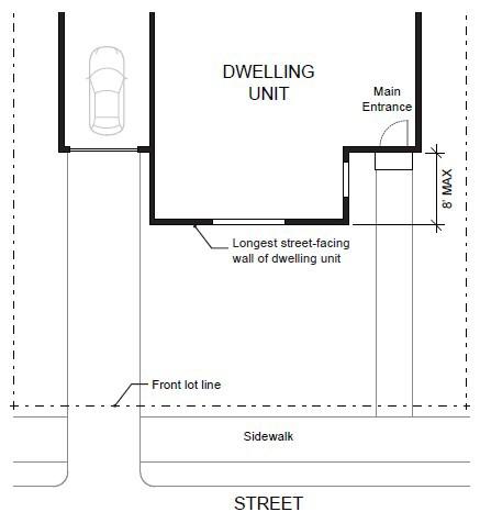
Figure 1. Main Entrance Facing the Street
Figure 2. Main Entrance at 45° Angle from theStreet
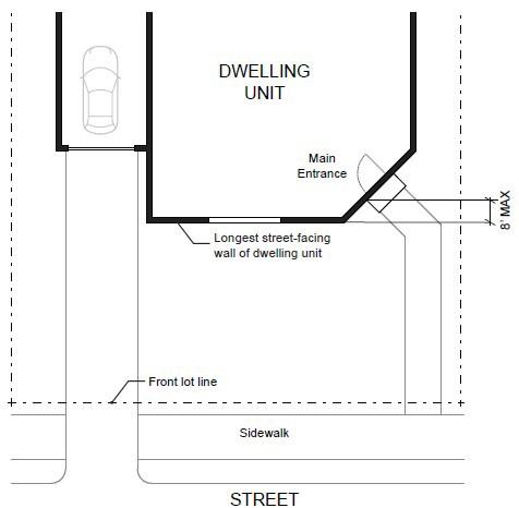
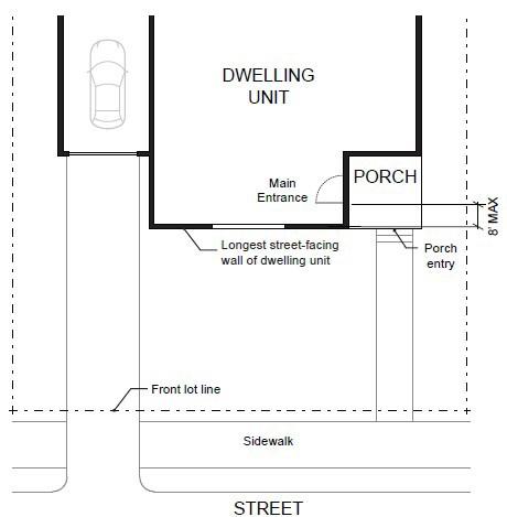
B. Unit definition. Each townhouse must include at least one of the following on at least one street-facing façade (see Figure4): 1. A roof dormer a minimum of 4feet in width, or
Figure 3. Main Entrance Opening onto a Porch
2. A balcony a minimum of 2 feet in depth and 4 feet in width and accessible from an interior room, or
3. A bay window that extends from thefacade a minimum of 2feet, or
4. An offset of the facade of a minimum of 2 feet in depth, either from the neighboring townhouseor withinthe façade of a single townhouse, or
5. An entryway that is recessed a minimum of 3feet, or
6. A covered entryway witha minimum depth of 4feet, or
7. A porch meeting the standards of subsection (A)(2)(d) of this section. Balconies and bay windows may encroach into a required setback area.
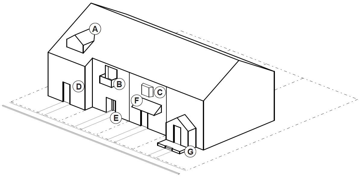
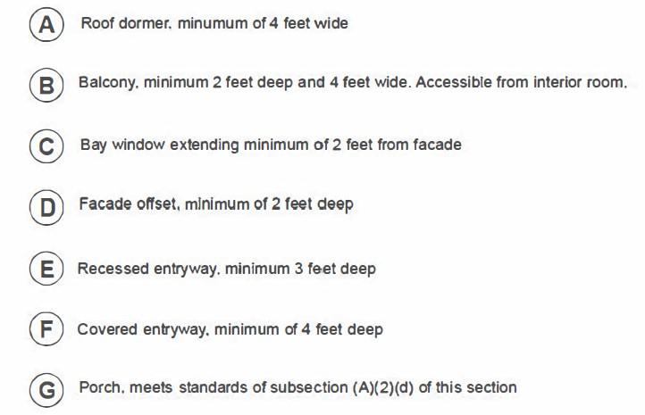
C. Windows. A minimum of 15 percent of the area of all street-facing facades on each individual unit must include windows or entrance doors. Half of the window area in the door of an attached garage may count toward meeting this standard. See Figure 5.
Figure 4. Townhouse Unit Definition
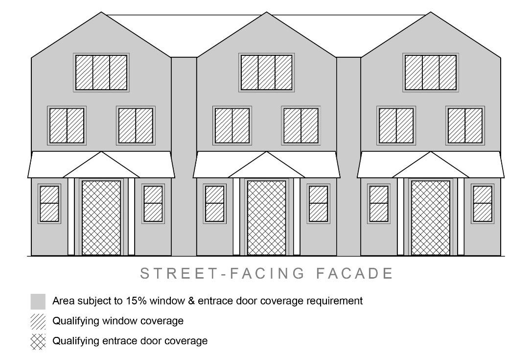
D. Driveway Access and Parking. Townhouses with frontage on a public street shall meet the following standards:
1. Garages on the front façade of a townhouse, off-street parking areas in the front yard, and driveways in front of a townhouse are allowed if they meet the following standards (see Figure 6).
a. Each townhouse lot has a street frontage of at least 15 feet on a local street.
b. A maximum of one (1) driveway approach is allowed for every townhouse. Driveway approaches and/or driveways may be shared.
c. Outdoor on-site parking and maneuvering areas do not exceed 12 feet wide on any lot.
d. The garage width does not exceed 12 feet, as measured from the inside of the garage door frame.
Figure 5. Window Coverage
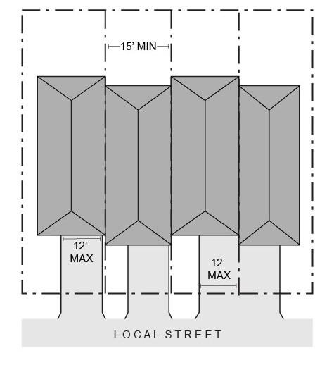
2. The following standards apply to driveways and parking areas for townhouse projects that do not meet all of the standards in subsection (1).
a. Off-street parking areas shall be accessed on the back façade or located in the rear yard. No off-street parking shall be allowed in the front yard or side yard of a townhouse.
b. A townhouse project that includes a corner lot shall take access from a single driveway approach on the side of the corner lot. See Figure 7.
Figure 6. Townhouseswith Parking in FrontYard
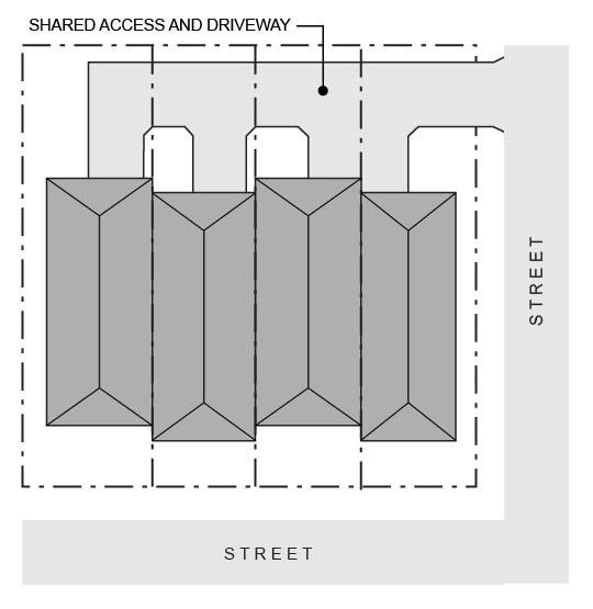
c. Townhouse projects that do not include a corner lot shall consolidate access for all lots into a single driveway. The driveway and approach are not allowed in the area directly between the front façade and front lot line of any of the townhouses. See Figure 8.
Figure 7. Townhouseson Corner Lot with Shared Access
Figure 8. Townhouseswith Consolidated Access
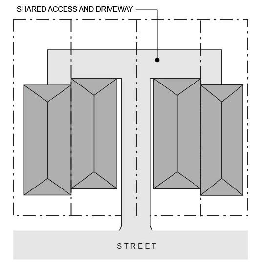
d. A townhouse project that includes consolidated access or shared driveways shall grant access easements to allow normal vehicular access and emergency access.
3. Townhouse projects in which all units take exclusive access from a rear alley are exempt from compliance with subsection (2).
4. All driveway accesses for townhouses must comply with Section 8.2820 (Access Management Standards) of the RDC.
E. Screen of Mechanical Equipment. All exterior ground mounted mechanical equipment located forward from the line of the front façade (living space and garage) of the building shall be screened from the street at the ground/eye level line of sight. Solar power, wind power, and satellite dishes necessitating placement on walls or roofs for normal operation are exempt from this provision.
F. Landscaping. See Section 8.0520 through 8.0540 for applicable landscaping requirements.
G. Fences. See Section 8.0340.
[Section 8.0142 added by Ord. #2018-09 passedSeptember 11, 2018]
[Section 8.0142 amended by Ord. #2020-15 passed November 10, 2020]
[Section 8.0142 “Architectural Design Standards for Multi Family Structures with 5 or more attached units” repealed in its entirety and replaced with Section 8.0142 “Townhouse Development and Design Standards byOrd. #2022-04 passed June 28, 2022]
[Section 8.0142 amended by Ord. #2022-09 passed December 13, 2022]
[Section 8.0142 amended by Ord. #2023-07 passed December 19, 2023]
8.0143Cottage Cluster Development and Design Standards.
1. Procedure. New cottage clusters shall be reviewed for conformance with the requirements listed in this Section.
2. Table A: Minimum Standards.
3. Building Separation. Cottages shall be separated by a minimum distance of six (6) feet. The minimum distance between all other structures, including accessory structures, shall be in accordance with building code requirements.
4. Unit Size.
A. The maximum building footprint for acottage is 900 squarefeet.
B. The maximum average floor area for a cottage cluster is 1,400 square feet per dwelling unit. Community buildings shall be included in the average floor area calculation for a cottage cluster.
5. Cluster Size.
A. Cottage clusters must include aminimum of four units per cluster.
B. A cottage cluster may include up to a maximum of 12 cottages per common courtyard. More than one cottage cluster may be permitted on a site.
6. Off-Street Parking and Access. Cottages shall meet the off-street parking and access requirements of Sections 8.0500 and 8.2820.
7. Design Standards. New cottage clusters shall meet the design standards in subsections A through Hof this section.
A. Cottage Orientation. Cottages must be clustered around a common courtyard, meaning they abut the associated common courtyard or are directly connected to it by apedestrian path, and must meet the following standards (see Figure1):
1. Each cottage within a cluster must either abut the common courtyard or must be directly connected to it by a pedestrian path.
2. A minimum of 50 percent of cottages within a cluster must be oriented to the common courtyardand must:
a. Have a main entrance facing the common courtyard;
b. Be within 10 feet from the common courtyard, measured from the façade of the cottage to the nearest edge of the common courtyard; and
c. Be connected to the common courtyardby a pedestrian path.
3. Cottages within 20 feet of a street property line may have their entrances facing the street.
4. Cottages not facing the common courtyard, or the street, must have their main entrances facing a pedestrian path that is directly connected to the common courtyard.
B. Common Courtyard Design Standards. Each cottage cluster must share a common courtyard in order to provide a sense of openness and community of residents. Common courtyards must meet the following standards (see Figure 1):
1. The common courtyardmust be a single, contiguous piece.
2. Cottages must abut the common courtyard on at least two sides of the courtyard.
3. The common courtyard must contain a minimum of 150 square feet per cottage within the associated cluster.
4. The common courtyard must be a minimum of 15 feet wide at its narrowest dimension.
5. The common courtyard must be landscaped in either active or passive park style. If the common courtyard is landscaped as an active-style park, it may be of any size and shall not be subject to the irrigated turf restriction of Section 8.0530(G).
6. Pedestrian paths must be included in a common courtyard. Paths that are contiguous to a courtyard shall count toward the courtyard’s minimum dimension and area. Parking areas, required setbacks, and driveways do not qualify as part of acommon courtyard.
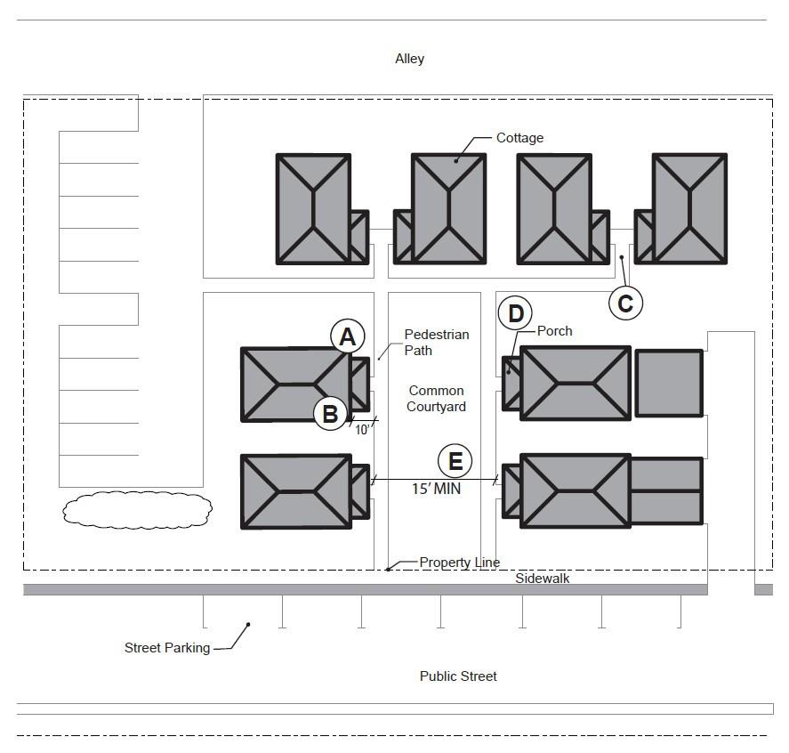
Figure 1. Cottage Cluster Orientation and Common Courtyard Standards
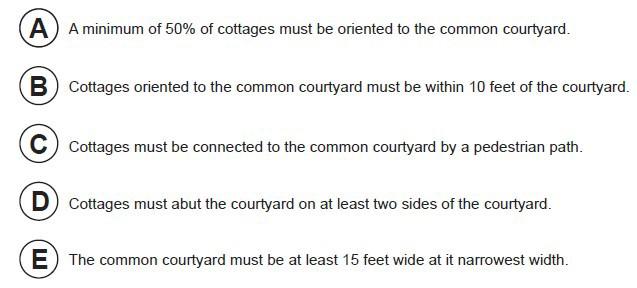
C. Community Buildings. Cottage cluster projects may include community buildings for the shared use of residents that provide space for accessory uses such as community meeting rooms, guest housing, exercise rooms, day care, or community eating areas. Community buildings must meet the following standards:
1. Each cottage cluster is permitted one community building, which shall count towards themaximum average floor area, pursuant to section 4.
2. A community building that meets the development code’s definition of a dwelling unit must meet the maximum 900 square foot footprint limitation that applies to cottages, unless a covenant is recorded against the property stating that the structure is not a legal dwelling unit and will not be used as a primary dwelling.
D. PedestrianAccess.
1. An accessible pedestrian path must be provided that connects the main entranceof each cottage tothe following:
a. The common courtyard;
b. Shared parking areas;
c. Community buildings; and
d. Sidewalks in public rights-of-way abutting the site or rights-of-way if there are no sidewalks.
2. The pedestrian path must be hard-surfaced and a minimum of four (4) feet wide.
E. Facades. Cottages must meet the architectural design standards for singlefamily detached dwellings in Section 8.0141(5).B.1 through 4.
F. Parking Design. (See Figure 2).
1. Clustered parking. Off-street parking may be arranged in clusters, subject to the following standards:
a. Cottage cluster projects with fewer than 16 cottages are permitted parking clusters of not more than five (5) contiguous spaces.
b. Parking clusters must be separated from other spaces by at least four (4) feet of landscaping.
c. Clustered parking areas may be covered.
2. Parking location and access.
a. Off-street parking spaces and vehicle maneuvering areas shall not be located:
i. Within 20 feet from any street property line, except alley property lines;
ii. Between a street property line and the front façade of cottages located closest to the street property line. This standard does not apply to alleys.
b. Off-street parking spaces shall not be located within 10 feet of any other property line, except alley property lines. Driveways and drive aisles are permitted within 10 feet of other property lines.
3. Screening. Clustered parking areas and parking structures shall be screened from sight of common courtyards and public streets at a height of no less than three feet.
4. Garages and carports.
a. Garages and carports (whether shared or individual) must not abut common courtyards.
b. Individual attached garages up to 200 square feet shall be exempted from the calculation of maximum building footprint for cottages.
c. Individual detached garages must not exceed 400 square feet in floor area.
d. Garage doors for attached and detached individual garages must not exceed 20 feet in width
G. Screening of Trash Enclosures. Centralized Trash Enclosures are required and shall be visually consistent, or architecturally compatible, in terms of color and materials withthe cottage units, a minimum six feet inheight, and contain sufficient space to accommodate both refuse disposal and recycling containers adequateto accommodate the degree of development.
H. Screening of Mechanical Equipment. All exterior ground mountedmechanical equipment located forward from the line of the front façade (living space and garage) of the building shall be screened from the street at the ground/eye level line of sight. Solar power, wind power, and satellite dishes necessitating placement on walls or roofs for normal operation are exempt from this provision.
I. Accessory Structures. Accessory structures must not exceed 400 square feet in floor area.
J. Existing Structures. On a lot or parcel to be used for a cottage cluster project, an existing single-family detached dwelling on the same lot at the time of proposed development of the cottage cluster may remain within the cottage cluster project area under the following conditions:
1. The existing dwelling may be non-conforming with respect to the requirements of this code.
2. The existing dwelling may be expanded up to a maximum height of 25 feet or the maximum building footprint of 900 square feet; however, existing dwellings that exceed the maximum height and/or footprint of this code may not be expanded.
3. The floor area of the existing dwelling shall not count towards the maximum average floor area of a cottage cluster.
4. The existing dwelling shall be excluded from the calculation of orientation toward the common courtyard, per subsection (6)(A).
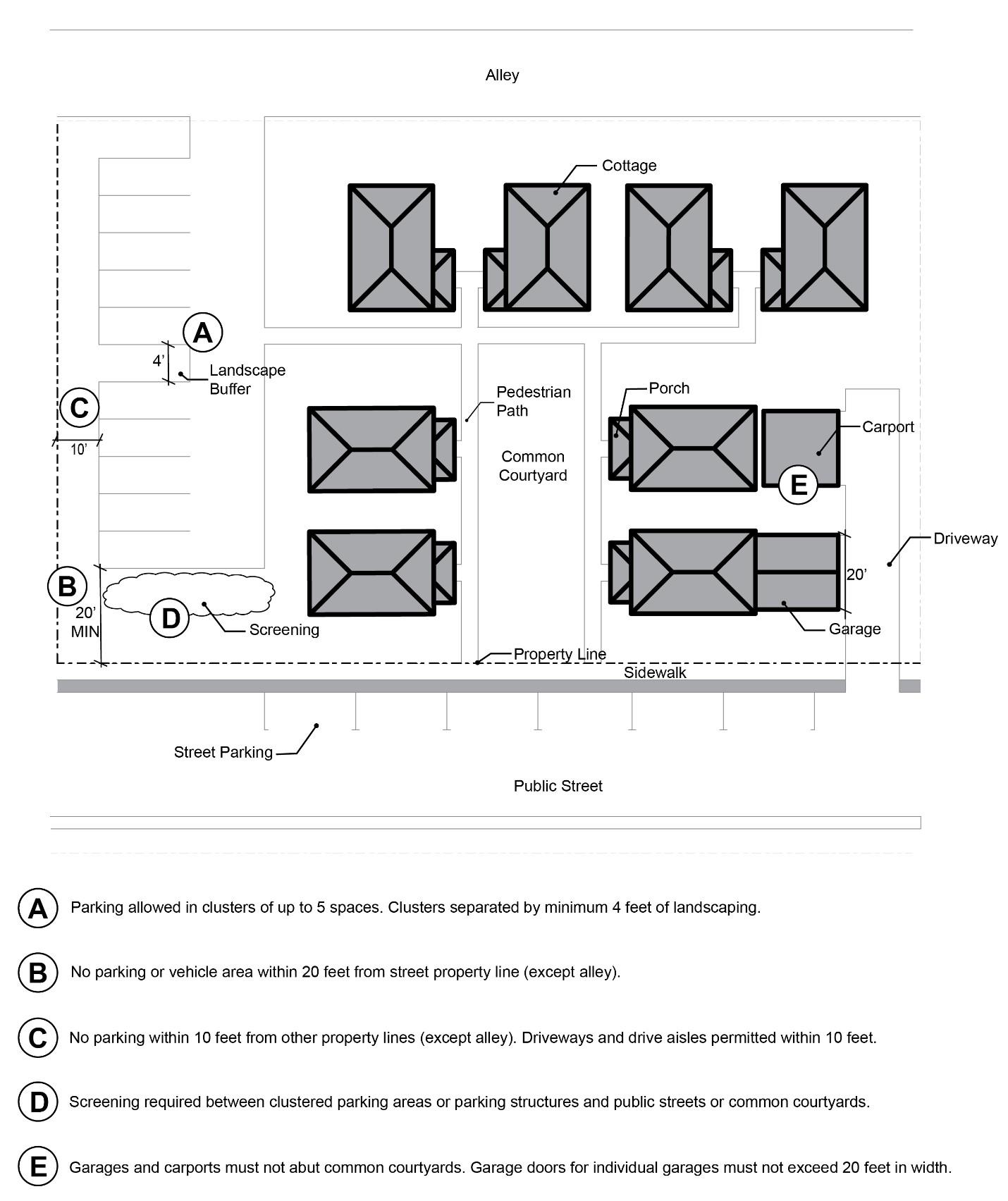
[Section 8.0143 added by Ord. #2022-04 passedJune 28, 2022]
[Section 8.0143 amended by Ord. #2022-09 passed December 13, 2022]
[Section 8.0143 amended by Ord. #2023-07 passed December 19, 2023]
8.0144 Conversion of Existing Commercial Structures for Housing.
1. Design and Review. A proposal for conversion of an existing commercial structure to housing is not required to comply with this section if the proposed conversion could be permitted through another use and review procedure. However, if an applicant is seeking approval of such proposal through this section, the proposal must comply with the entirety of this section in order tobe approved.
A. For any proposal to convert an existing commercial structure or portion thereof to housing, regardless of the zoning of the subject property, system development charges will be applied to the proposed development as the City deems appropriate, but the charges shall be reduced by the full nominal amount of the water and wastewater system development charges paid at the time the commercial structure was originally constructed, if any. The parking requirements
Figure 2. Cottage Cluster Parking Design Standards
for conversion of an existing commercial structure or portion thereof to housing are described in RDC Section 8.0500(2).
B. Conversion of an existing commercial structure or portion thereof to housing on a subject property that is located within a non-residential zoning district shall not require a zone change or conditional use review to allow the proposed residential use.
[Section 8.0144 added by Ord. #2023-07 passedDecember 19, 2023]
8.0145 Public-Owned Affordable Housing Developments. Proposals which comply with the standards of this section shall be approved.
1. Ownership. The subject property for the Public-Owned Affordable Housing Development proposal must meet one of the following conditions:
A. The subject property is located outside of the Airport and Industrial zones and is owned by a public body or a nonprofit; or
B. The subject property is located within the M-1 zone and is owned by a public body.
2. Affordability Standard. In order to qualify as a Public-Owned Affordable Housing Development, the entirety of the units proposed on the subject property must, at a minimum, be:
A. Available to rent or own at 80% of AMI based on the most recent HUD Income Limits for the Bend-Redmond Metropolitan Statistical Area and controlled by an affordable housing covenant as defined in ORS 456.270 for a period of no less than thirty years; or
B. Available to rent or own at a collective average of 60% of AMI based on the most recent HUD Income Limits for the Bend-Redmond Metropolitan Statistical Area and controlled by an affordable housing covenant as defined in ORS 456.270 for a period of no less than thirty years.
3. Review. The development of Public-Owned Affordable Housing on a subject property located within a non-residential zoning district shall not require a zone change or conditional use review to allow the proposed residential use.
4. Density and Height Bonus. Any Public-Owned AffordableHousing Development proposal located within aresidential zone shall be granted one of the following density and height bonuses. In this section, effective maximum density shall mean the greater of either the maximum number of lots per acre or the maximum number of dwelling units per acre.
A. When the proposed Public-Owned Affordable Housing Development is subject to an effective maximum density standard of 16 dwelling units per acre or less, that maximum density standard shall be increased by 200%. Additionally, the maximum building height standard shall be increased by 12feet.
B. When the proposed Public-Owned Affordable Housing Development is subject to an effective maximum density standard between 17 and 45 dwelling units per acre, that maximum density standard shall be increased by 150%. Additionally, the maximum building height standard shall be increased by 24 feet.
C. When the proposed Public-Owned Affordable Housing Development is subject to an effective maximum density standard of 46 dwelling units per acre or more, that maximum density standard shall be increased by 125%. Additionally, the maximum building height standard shall be increased by 36feet.
The City reserves the right to reduce the height or density of the development as necessary to address health, safety, or habitability issues, including fire safety concerns, or to comply with a protective measure adopted pursuant to a statewide land use planning goal. If the City has found a reduction of the density and/or height bonus
CHAPTER
to be necessary on this basis, the City shall provide findings supported by substantial evidence as part of the planning review of the Public-Owned Affordable Housing Development.
[Section 8.0145 added by Ord. #2023-07 passedDecember 19, 2023]
COMMERCIAL USE AND INDUSTRIAL USE ZONES
8.0150Strip-Service Commercial C-1 Zone.
8.0155Central Business District Commercial (CBD)C-2 Zone.
8.0160Special-Service Commercial C-3 Zone.
8.0165Limited Service Commercial C-4Zone.
8.0166Limited Service Commercial C-4A Zone: Except as provided in 8.0190 and 8.0195, the standards and criteria for development in the C-4A Zone shall apply to development in the C-4A Zone.
8.0170Tourist Commercial C-5 Zone.
8.0175Downtown Overlay District. In the DowntownOverlay District, the following regulations shall apply:
1. Purpose. The purposeof the Downtown Overlay District is to promote and sustain:
A. Economic Growth - Assure opportunities for a stable, vital, diverse, and competitive economy in the heart of the city.
B. Vibrant Downtown - Strengthen downtown as avibrant,mixed-use district that draws a wide spectrum of residents and visitors.
C. Downtown Appearance - Improve and enhancethe appearance of the built environment and natural features throughout downtown, especially along primary commercial corridors, and other major arterials.
D. Historic Character - Preserve and retain historic structures and cultural resourcesthroughout downtown.
E. Pedestrian Environment - Improve and enhance the pedestrian environment throughout downtown, as well as the pedestrianconnections to surrounding neighborhoods and civic resources.
2. Intent. The intent of the Downtown Overlay District is to:
A. Encourage avibrant mix of pedestrian-oriented uses, including residential, shopping and entertainment uses;
B. Increase the density and intensity of development;
C. Establish height, bulk, and lot coverage regulations that balance existing urban fabric with a desired character for downtown;
D. Promote active ground floors by regulating the quantity and location of doors and windows;
E. Establish standards for setbacks and landscaping that encourage and promote a strong pedestrian environment.
F. Establish parking and access standards that support pedestrian activity.
3. Uses Permitted. (Please see 8.0190 TableC)
4. Development Standards. In the Downtown Overlay District, the following dimensional standards shall apply:
A. Minimum Building Setback: Two (2) feet. Surface treatment needs to be of similar nature as adjoining sidewalk.
B. Maximum Building Setback: Ten (10) feet. Surface treatment beyond two feet from the sidewalk needs to be landscaped or treated with decorative pavers. Use of irrigated turf or asphalt is prohibited. For full-block developments, a minimum of 50% of the primary street-facing building façade must be located at the minimum two (2) feet setback as described in 4.A.
C. Minimum LandscapedArea: No minimum landscaping requirement.
D.
Ground Floor Windows: Ground floor windows must be at least 50% of the building length and 50%of the street-facing façade to a minimum height of 10’-0” above finished right-of-way. If the site has two or more frontages, the Ground Floor Window standards is only required on the primary façade. The other façade has a minimum requirement of 50% of the building length and 25% of the ground floor wall area. Windows arerequired tobe transparent.
Please note: Ground floor wall area is defined as all wall areas up to ten (10) feet above the finished grade.
Ground Floor Windows – Residential Use: 25% of the ground floor wall area must be transparent.
E. Main Entrance: The front door to all buildings must be oriented to the primary street. In the event that a building is located on the corner, the front doorshould be oriented directly to the corner or located within fifty (50) feet of the corner of the primary street.
F. Pedestrian Connection from Front Door to the Street: Create a straight-line connection from the front door tothe primary street sidewalks.
G. Exterior Display and Storage: Permanent storage between the building and the street is prohibited.
H. Screening HVAC Equipment: Screen rooftop mechanical equipment through extended parapets or other roof forms that are integrated into the overall composition of the building. Screen ground floor mechanical equipment. Renewable energy generation devicesmay be exempt from screening, subject to site and design review by a hearings body.
I. Parking andAccess: Parking between the building and the primary street is prohibited.
5. Building Height. The intent of the building height standards is to set guidelines to assist the development in the downtowncore that increase economic activity, capital value and encourage investment in the downtown core. The following guidelines provide performance standards that encourage innovative design and development techniques within specific parameters. They are generally prioritized to include the following:
Compatibility with existing downtown buildings and surrounding residential neighborhoods; Human scale related to building design, including height and massing, and its impact on solar access and views; Multi-story and mixed-use buildings for increased density and diversified use on premium land inthe urban core; Development incentives for increased height, based on Performance Bonuses.
A. Maximum Height: Themaximum height allowed for the downtown overlay district for all structures that are not within one full city block of a residential zone and west of SW 5th Street is sixty (60) feet, and east of SW 5th Street is 75 feet. The maximum height of structures east of 5th Street may be increased if a Conditional Use Permit for the structure is approved by aHearings Body. The following standards shall apply to structures in the DowntownOverlay District.
1. Street Wall Height: Maximum street wall façade height for the downtown overlay district for all structures that are not within one full city block of aresidential zone is forty-five (45) feet.
2. Upper-floor Setback: Buildings taller than forty-five (45) feet must step back upper stories by at least 10 feet measured from the façade of the street wallfacing the street, public park, or open space.
3. Residential Buffer Zone: All buildings in the Downtown Overlay District
within one full city block adjacent to a residential zone shall be considered to be part of the Residential Buffer Zone, wherein the following height standards apply:
a. Maximum Height: The maximum height allowed for all structures within the Residential Zone Buffer is fifty (50) feet.
b. Street Wall Height: Maximum street wall façade height for structures withinthe Residential Zone Buffer is thirty-five (35) feet.
c. Upper Floor Setback Requirements: Buildings taller than thirtyfive (35) feet must step back upper stories by at least 10 feet measured from the façade of the street wall facing the street, alleyway, public park, or open space.
B. Architectural Standards for Buildings Taller Than 45 Feet: In addition to the existing Site and Design Review criteria and Downtown Overlay District Design Standards, the following architectural standards will apply to all buildings taller than forty-five(45) feet.
1. On upper floors use windows and/or architectural features that provide interest on all four sides of the building when permitted within the building code.
2. Abrupt changes in building heights and/or roof orientation should be diminished by offsets of building form and mass.
3. Use recesses and projections to visually divide building surfaces into smaller scaleelements.
4. Use color tovisually reduce the size, bulk, and scale of the building.
5. Buildings sixty feet or over shall provide rooflines with articulated features.
6. Location of back flow prevention devices and the fire sprinkler riser must be identified on project plans submitted for site and design review and shall be located inside the building.
C. Buildings within the Downtown Overlay District shall only be permitted to exceed 75 feet if they comply with the standards set forthbelow.
1. Performance Bonus: Additional building height above 75 feet may be approved if the project achieves a minimum of twelve (12) points from the following:
Affordable Housing: The project provides affordable housing, per City standards, for low- and moderate-income households, as a percentage of the total number of residential units built. 3points for 10%, 4 points for 15%,and 5 points for 20% of total number of residential units built for affordable housing.
Workforce Housing: The project provides workforce housing, per City standards. 1 point for 10%, and 2 points for 20% of total number of residential uses built for workforce housing.
Public Plaza: The project incorporates a public plaza which is at least 5% of the gross site area. Theplaza shall be on the street side of the building, and open and free to the public at alltimes and shallremain for a period of at least ten years. 1 point per 5% public plaza space, with a maximum of 4 points.
Public Art: 0.5% of the overall project budget is set aside for an on-site public art project that shallremain for the life of the building, or 1.0% of the overall project budget is provided to the City for off-site public art shallbe awarded 2
3 - 5 pts.
1 – 2 pts.
1 - 4 pts.
2 - 4 pts.
points. Increasing thesepercentages to 0.75 % and 1.5% respectively increases the number of points awarded to 3. Increasing these percentages to 1.0% and 2.0 % respectively increases the points awarded to 4.
View Access and Preservation: The project provides a public viewing deck or decks, or similar features, which are at least 5% of the gross site area. The viewing deck(s) should be located at least sixty (60) feet above ground level and provide significant free public access to views of surrounding Central Oregon features, such as the Cascade Mountains and Smith Rocks, and shall remainfor a period of at least ten years.
Economic Vitality: The project provides additional economic benefit to the City by providing retail sales and/or hospitality uses on multiple levels. Total floor area dedicated to entertainment, eating anddrinking, retail services,and service commercial uses as presented in Section 8.0190, Table C of the Redmond Development Code, must equal or exceed 75% of the building footprint and shall remain for a period of 5 years will be awarded 4 points. One additional point will be awarded for each additional 25% of floor area (as defined by the building footprint) for retail, entertainment or hospitality uses up to amaximum of 8 points. 4 - 8 pts.
Historic Preservation: The project provides forpreservation or adaptive reuse of all buildings on the City’s Inventory of Historic Resources located on the project site in amanner consistent with the Secretary of the Interior’s Standards for the Treatment of Historic Resources shall beawarded 2 points. The Hearings Body may increase the points up to 4 points for projects on the National Register of Historic Places. As an alternative, 1.0% of the overall project budget is provided for a specific historic preservation project that will be completed within a specific timeframe in the Cityof Redmond or is provided to the Redmond Historic Commission for historic Redmond projects (not operations) shallbe awarded 2 points. The provision of 2% of the overall project budget will receive 4 points.
Sustainable Building: Project is built to LEED standards, or equivalent green building practices. It will be up tothe applicant toprovide material supporting equivalent building practices. (Certified is awarded 2 points, Silver certification is awarded 3 points, Gold certification is awarded 4 Points, and Platinum is awarded 5 points.)
Parking: In addition to the required parking for the development, the project provides at least 7 on-site parking spaces for public use between 8:00 – 6:00 PM that shall remain for the life of the building. 1 point per 7 public parking spaces, with amaximum of 5 points.
Total:
2.
Building Bulk for Buildings over 60 feet in Height:
2 - 4 pts.
2 - 5 pts.
1 - 5 pts.
36 pts.
a. Floor Area Ratio (FAR): Buildings between sixty (60) feet and eighty-five (85) feet shall have a maximum floor area ratio of 4.0.
Buildings eighty-five (85) feet and taller shall have a maximum floor area ratio of 5.0. Floor Area Ratio (FAR) is a method of calculating allowable floor area in a development as a means of controlling “bulk” and “massing” of larger developments, often encouraging setbacks and step backs, and progressively slender upper floors.
3. Application Requirements for Buildings Over 75 Feet: Planning applications submitted for new buildings over 75 feet tall shall include the following additional items to assist the City in the analysis and decisionmaking process.
a. Three-Dimensional Digital Model: A complete threedimensional digital model of the proposed building.
b. Solid WasteManagement Plan: A solid wastemanagement plan to showhow the project meets or exceedsthe City’s Solid Waste Guidelines, to the approval of the Utilities Director.
c. Utilities InfrastructureAnalysis: An engineer’s evaluation of existing utilities infrastructure and recommendations to ensurethat the project will have adequate water pressure for domestic use and fire flows andthat the collection system in the area surrounding the project is sufficient to meet the project’s impact.
d. Emergency Services Access Plan: A written and graphic plan, created in consultation with the City’s FireMarshal to showhow access to site and upper floors for emergency response personnel will be provided.
e. Public Safety Plan: A security plan, created in consultation with the Police Department for all proposed buildings that include publicly accessible areas such as parking garages, courtyards, public stairways, elevators, and decks.
4. Height Design Departure: In addition to the availability of variances as noted in 8.0700 – 8.0720, a design departure procedure will be established to allow a project to achieve flexibility in the application of prescriptive development standards and height performance bonuses (limited to two height performance bonuses). A 20% departure may be granted administratively. In order to allow a departure from a code standard, an applicant must demonstrate that it would result in a development that better meets the intent of the purpose of the regulation and applicable design guidelines.
6. Design Standards. Any change to the exterior of a building or a property shall be reviewed by the Community Development Department pursuant to ArticleIV Section 8.3040 of the Redmond Development Code.
7. Off-Street Parking. Subject to the standards of 8.0505 –8.0515.
A. Fee-In-Lieu of Parking: The purpose of these provisions is to allow development in the Downtown Overlay District to reduce the number of off-street parking spaces through payment of a fee in order to meet the parking requirements set forth in this Code. These provisions may be utilized for parking required for new construction or for an increase in required parking resulting from the change of use of an existing building.
Payment made to the City in-lieu of supplying the required off-street parking spaces for a project in the Downtown Overlay District may be provided as follows:
1. By the one-time payment of a non-refundable parking and mobility improvement fee to the City in the amount established in the City’s Fee Schedule, paid prior to the issuance of Certificate of Occupancy. Fees collected shall be used to fund parking, street improvements or facilities to improve mobility or enhance pedestrian connectivity and safety in the Downtown Overlay District.
2. From time to time the City shall establish the value of off-street parking facilities on a per parking space basis, used to establish the above parking and mobility improvement fee.
3. The City Engineering shall evaluate development proposals requesting to pay an in-lieu fee through conducting a Transportation System Analysis or parking study.
4. Any such request for parking in-lieu may be denied or reduced by the Community Development Director, or designee. The Director, or designee, shall determine:
a. Whether there is sufficient alternative parking within a two to fourblock radius of the project location.
b. Whether approval of the request would have an adverse effect on surrounding neighborhoods.
c. Whether the request meets the Purpose and Intent of the Downtown Overlay District Zone.
d. Compliance with the Redmond Comprehensive Plan 2040 and support plans, as amended.
[Section 8.0175 amended by Ord. #2016-17 passed January 31, 2017]
[Section 8.0175 amended by Ord. #2022-04 passed June 28, 2022]
[Section 8.0175 amended by Ord. #2022-09 passed December 13, 2022]
[Section 8.0175 amended by Ord. #2023-07 passed December 19, 2023]
8.0180Light Industrial (M-1) Zone.
8.0182General Industrial (M-1.5) Zone.
8.0185Heavy Industrial (M-2) Zone.
8.0186Large Lot Industrial (LLI) Zone.
1. LLI Zone Regulations. The following standards and regulations apply inthe LLI Zone:
A. The lot shall adhere to the designation as acknowledged by the Central Oregon IntergovernmentalCouncil.
B. No property that is zoned LLI can be rezoned to another zone within ten years of the LLI designation.
C. The minimum lot size is 50 acres. Division or separation of lots or parcels within the site to new lots or parcels less than the minimum lot size is not allowed until the site is developed with a primarytraded sector use requiring a large lot.
D. Allowed uses are tradedsector uses as provided in Section 2.
E. Uses allowed tosupport a primary user included:
1. Subordinate industrial uses that rely upon and support the primary traded sector use;
2. Service commercial uses that support the traded sector uses if they are limited to7500 square feet per use; and
3. Retail uses accessory to a traded sector use and limited to 7500 square feet.
F. Conceptual Phased Site Development Plan. A Conceptual Phased Site Development Plan is required for each primary traded-sector use as part of the
Site and Design Review process in addition to the criteria and requirements outlined in Article IV of this code. In addition to the requirements outlined in Section 8.3025, the following elements shall be considered as part of the Conceptual Phased SiteDevelopment Plan:
1. Open Space. Generally identify land provided for open space on the site.
2. Connectivity and Trail Networks. A conceptual transportation plan for streets, pedestrians connectivity and trail networks. E.g., Connection of bicycle routes and pedestrian network for utility and recreational purposes.
3. Site Design. Describe how the design elements (i.e., streets, open spaces, signage, and architecture) are integrated and coordinated throughout the site.
4. Analysis of Anticipated Utility Consumption by Phase. Analysis of the anticipated utility consumption by phase for wastewater, water, power, natural gas, and other utility infrastructure necessary to support the development.
2. LLI Zone Uses Permitted. The following uses are allowed outright or conditionally in the Large Lot Industrial Zone:
O PerORS285B.280,tradedsectormeansindustriesinwhich memberfirmsselltheirgoodsorservicesintomarketsforwhich nationalorinternationalcompetitionexists,aswellasusesand servicesthatdirectlybenefittradedsectoruses.Alloweduses includemanufacturing,processingplants,distributioncenter, warehousing,researchanddevelopment,andhighereducation institutions
Subordinate Industrial Uses
Service Commercial Uses
Retail Uses
O Afteraprimarytraded-sectorusehasbeensited,subordinate industrialusesareallowed.Subordinatemeansindustriesthat relyuponandsupportaprimarytradedsectoruse
C Afteraprimarytraded-sectorusehasbeensited,service commercialusesareallowedthatsupportthetradedsectoruses andshallbelimitedto7500squarefeetperstructure
C Afteraprimarytraded-sectorusehasbeensited,retailuses,and eatinganddrinkingestablishmentsareallowedasaconditional useandshallbelimitedto7500squarefeetperuseinthe structure.
O=Outrightuses,C=ConditionalUses
3. Minimum Standards. See Table D, 8.0195.
[Section 8.0186 added by Ord. #2015-11 passedSeptember 22, 2015] [Section 8.0186 amended by Ord. #2022-09 passed December 13, 2022]
8.0190Table C, Uses Permitted. The following uses identified below are allowed outright or conditionally in each of the Commercial and Industrial zones. Outright or conditional uses in the M-1.5 zone may be permitted Conditionally in the M-1 or M-2 zones; this allowance does not apply for uses Not Allowed (“N”).
“O” means Permitted Outright
“C”means Permitted Conditionally
“N”means Not Allowed
AffordableHousing, containing100%affordable dwellingunits
BedandBreakfast
BoardingHouse
MixedUseWorkforce Housing,containingground floorcommercialand100% workforceoraffordable dwellingunits
Mustliveonsite.
*Onlyifalsoallowedbythe underlyingzonedistrict.
*ResidentialUseonground floorrestrictedto<25%and shallnotbeinfrontof building.
groundfloor
ResidentialUseon groundfloor<25%
Notinfrontofbuilding. ResidentialUseon groundfloor>25%
ResidentialConversionof ExistingCommercial Structure
SingleFamilyDetached Dwelling(includingADUs) andDuplexesonground floor
AttachedSingleFamily andtriplexandquadplex abovegroundfloor
Resumptionofa residentialuse
SeeSection8.0144.*Onlyif alsoallowedbythe underlyingzonedistrict.
*Onlypermittedforthose usespre-datingtheadoption oftheC-2ZoneAmendments andDowntownOverlay DistrictonAugust12,2008.
Onlyaspreviously established.
Eating and Drinking:
Bakery(retail/sit-down)
Bar,Lounge,Tavern, Nightclub
Café,Restaurant(sit-down), Diner, BrewPub
CHAPTER 8 DEVELOPMENT REGULATIONS
Restrictions and Requirements:
uses." Café,Restaurant, Espresso(drive-through)
MobileFoodPod
MobileFoodUnit
MobileFoodVendoron privateproperty
publicproperty
uses."
PermittedthroughSiteand DesignReview.Notallowed onlotswithdwellingunit(s).
Permittedthrougha TemporaryUsePermit, Section8.0380.Notallowed onlotswithdwellingunit(s).
PermittedthroughBusiness LicensingprovisionsinCity Code,Section7.005etseq. Canonlyoperatebetween8 AMand9PMfornomore thantwoconsecutivedays withina90-dayperiodand mustbelocatedonreal propertyinassociationwith anevent.
PermittedthroughSpecial EventsprovisionsinCity Code,Section7.350etseq. orParksReservationPermit.
Noautobodyworkpermitted as"detailing".
Useforexistingbusinesses priortoAugust12,2008.
AutoSales(newand used);AutoRentals
CHAPTER 8 DEVELOPMENT REGULATIONS
Definedinpartbysomeonsiteautostorage.
**ExemptedasaConditional Useforexistingbusinesses priortoAugust12,2008.
**ExemptedasaConditional Useforexistingbusinesses priortoAugust12,2008.
Includesautolubeshops ('sameday'service).
**ExemptedasaConditional Useforexistingbusinesses priortoAugust12,2008.
Includesmotorcycles,ATVs, otherrecreationalvehicles.
Steamcleaningpermittedin theindustrialzones.
**ExemptedasaConditional Useforexistingbusinesses priortoAugust12,2008.
**ExemptedasaConditional Useforexistingbusinesses priortoAugust12,2008.
Junkyard
LandscapingSupply(Bulk)
LumberMill
Manufacturing (HeavyIndustrial)
Manufacturing (LightIndustrial)
MedicalResearchFacility
PrecisionMachineShop
RetailUsesinsupportof primaryIndustrialUse
RockCrushing/Recycling
StoringofHides
WholesalePrintingand Distribution
WoodProduct Manufacturingand Assembly
CHAPTER 8 DEVELOPMENT REGULATIONS
AutoWreckingYard'isa separatecategory.
Outdoorstorageofbulk landscapingmaterial.
SubjecttoDEQrequirements andneighborhood compatibility.
Excludesresearchusing biohazardousmaterial.
Mustbefullyenclosedin"C" zonesthatpermitthisuse.
Mustbelessthan50%ofthe grossfloorarea.
CHAPTER 8 DEVELOPMENT REGULATIONS
(non-landscaping).
CHAPTER 8 DEVELOPMENT REGULATIONS
O*Maximumsize=10,000squarefeet
O**Maximumsize=20,000squarefeet
[Section 8.0190 amended by Ord. #2012-10 passed August 14, 2012]
[Section 8.0190 amended by Ord. #2015-04 passed May 19, 2015]
[Section 8.0190 amended by Ord. #2016-17 passed January 31, 2017]
[Section 8.0190 amended by Ord. #2017-12 passed December 12, 2017]
[Section 8.0190 amended by Ord. #2018-09 passed September 11, 2018]
[Section 8.0190 amended by Ord. #2020-15 passed November 10, 2020]
[Section 8.0190 amended by Ord. #2022-04 passed June 28, 2022]
[Section 8.0190 amended by Ord. #2022-09 passed December 13, 2022]
[Section 8.0190 amended by Ord. #2023-07 passed December 19, 2023]
industrialdevelopmentand withinthemanufacturing structure,aconditionaluse permitisnotrequired.
CHAPTER 8 DEVELOPMENT REGULATIONS
8.0195Table D, Minimum Standards. The following minimum standards are required in each of the Commercial and Industrial zones as follows (alldistances aremeasured in feet):
Minimum Yard Setbacks
Note: Residential uses permitted in Commercial and Industrial zonesshall besubject to thedensity standardsfor theR-5 zone, except for the Downtown Overlay District and theC-2 and C-3 zones, for which thereisno maximum density standard.
*Theminimumlotsizeshallbedeterminedbasedondemonstrationoftheabilitytodevelopthesiteinaccordancewiththezonestandards,offstreetparkingstandards,Site&DesignReviewStandards,landscapingrequirementsandotherapplicableDevelopmentCodeprovisionswithout adverseimpacttowaterandlandresourcequalityandadjoiningproperties.
A Arearyardabuttinganalleyshallbe25feetfromthepropertylinetofoundationwhenthealleyisusedtoservicethecommercialestablishment and10feetinothercases.
B Maximumbuildingheightislimitedto45feetforallstructureswithinonefullcityblockofaresidentialzone.Whereallowedbuildingsover45 feetshallconformtheUpperFloorSetbackStandardsintheDowntownOverlayZoneSiteandDesignStandardsinSection8.0175(5).
C RearyardsalongthenorthsideofHighlandAvenue/Highway126betweenSW23rdandSW27thStreetsshallhaveaminimumarterial setbackof25feet.Allotherrearsetbacksadjacenttoarterialsshallbe50feet.
D TheminimumsetbackbetweenastructureandanexistinguseintheC-5zoneshallbe5feetfromthepropertylineand10feetfromany adjacentstructureonthesubjectsiteoradjacentproperty.
E Nouselocatedinanindustrialzoneadjacenttooracrossthestreetfromaresidentialzoneshallexceed60%ofthelotareaincludingbuildings, storageorfacilities,andoff-streetparkingandloading.
F Theminimumsideyardinanindustrialzoneshallbe10feetfor1and2storybuildingsand15feetfor3storybuildings.
G Maximumbuildingheightislimitedto50feetforallstructureswithinonefullcityblockofaresidentialzone.Whereallowed,buildingsover50 feetshallconformtheDowntownOverlayDistrictSiteandDesignStandardsinSection8.0175(5).Themaximumbuildingheightforstructures westofSW5th Streetis60feet.Themaximumbuildingheightforstructureseastof5th Streetis75feetandmaybeincreasedabove75feetifa ConditionalUsePermitforthestructureisapprovedbyaHearingsandReviewAuthority.
H Existingzero-lotlinestructuresasofAugust12,2008,shallbeexemptfromthisstandard.Atthetimethefrontfaçadeofabuildingorabuilding isdemolishedasdefinedbythisCode,thenthebuildingshallcomplywiththisstandardunlessavarianceisapproved.
I Fullblockdevelopmentsrequireaminimumof50percentofthebuildingfaçadetobedevelopedtotheminimumsetback.Asphaltandirrigated turfareprohibitedinthefrontyardsetback(concrete,pavers,landscapingareallowed).
[Section 8.0195 amended by Ord. #2012-10 passed August 14, 2012]
[Section 8.0195 amended by Ord. #2014-12 passed May 27, 2014]
[Section 8.0195 amended by Ord. #2015-11 passed September 22, 2015]
[Section 8.0195 amended by Ord. #2018-09 passed September 11, 2018]
[Section 8.0195 amended by Ord. #2020-15 passed November 10, 2020]
[Section 8.0195 amended by Ord. #2022-04 passed June 28, 2022]
[Section 8.0195 amended by Ord. #2023-07 passed December 19, 2023]
CHAPTER 8 DEVELOPMENT REGULATIONS
8.0200Fairgrounds FG Zone.
OTHER ZONES
8.0205Park Reserve Open Space (OSPR) Zone.
8.0210Public Facility PF Zone.
8.0215Park Zone.
8.0220Table E, Permitted Uses. The following land uses are permitted outright or conditionally in each respective zone:
“O”meansPermittedOutright “C”meansPermittedConditionally “N”meanNotAllowed
SeeSection8.0145
Inconjunctionwithausepermitted bythissection,acaretakerresidence orinOSPRwithapproveddensity transfer.
Review
PermittedthroughTemporaryUse Permit,Section8.0380.
PermittedthroughBusiness LicensingprovisionsinCityCode, Section7.005etseq. Canonlyoperatebetween8Amand 9Pmfornomorethantwo consecutivedayswithina90-day periodandmustbelocatedonreal propertyinassociationwithanevent.
PermittedthroughSpecialEvents provisionsinCityCode,Section 7.350etseq.orParksReservation Permit.
CHAPTER 8 DEVELOPMENT REGULATIONS
Outrightonlywhenapprovedinthe CompPlanorOtherPublicFacilities PlanforOSPRandParkZones. Conditionaluseifadjacentto“R” zone(appliestothePFzoneonly)
InthePublicFacilityZone,recreation facilitiesshallbeinpublicownership. *AppliestoAirport Compatibility Zone.
InthePublicFacilityZone,outright usesforpublicandnon-profit agencies.Conditionalusepermits arerequiredforcommercialuses exceedingsix(6)consecutive monthsorsix(6)monthswithinthe samecalendaryear.
InthePublicFacilityZone, commercialusesarelimitedtono morethan50%ofthetotalfloorarea, buildingfootprintorlotarea, whicheverismostrestrictive. Commercialusesubjecttoa TemporaryUsePermit.
*AppliestoAirportCompatibility Zone.
ReviewedunderORS197.782. Emergencysheltersfornatural disasterresponsearenotsubjectto review.
SeeSection8.0370,Supportive ShelterStandards.
CHAPTER 8 DEVELOPMENT REGULATIONS
OtherUses O
Lightindustrial,manufacturing,or commercialusesconsistentwith applicableprovisionsofeitherthe RedmondAirportMasterPlan, RedmondComprehensivePlanorif theusesdonotcreateasafety hazardorotherwiselimitapproved airportusesasdeterminedbythe AirportDirector.
[Section 8.0220 amended by Ord. #2009-04 passed April 28, 2009]
[Section 8.0220 amended by Ord. #2015-04 passed May 19, 2015]
[Section 8.0220 amended by Ord. #2016-17 passed January 31, 2017]
[Section 8.0220 amended by Ord. #2018-09 passed September 11, 2018]
[Section 8.0220 amended by Ord. #2020-15 passed November 10, 2020]
[Section 8.0220 amended by Ord. #2022-04 passed June 28, 2022]
[Section 8.0220 amended by Ord. #2023-07 passed December 19, 2023]
8.0225Table F, Minimum Standards. The following minimum standards are required in each respective zone (all distances aremeasured infeet):
CHAPTER 8 DEVELOPMENT REGULATIONS
*Theminimumlotsizeshallbedeterminedbasedondemonstrationoftheabilitytodevelopthesiteinaccordancewiththezone standards,off-streetparkingstandards,Site&DesignReviewStandards,landscapingrequirementsandotherapplicable DevelopmentCodeprovisionswithoutadverseimpacttowaterandlandresourcequalityandadjoiningproperties.
A UnlessapplicantprovideswrittendocumentationfromtheFireDepartmentthatthestructurewillnotexceedthecapabilityof availablefire-fightingequipment. The maximum building height for all structuresin the AirportZone orAirport Compatibility Zoneis 60feet. If the structure iswithin 200 feet of the airfield security/perimeter fence, themaximum building height for all structuresis 45feet. No building permit will beissued in theAirport Zoneor Airport Compatibility Zone until theFAA Form 7460-1is received by theCityof Redmond from the FAA. SeetheAirportControlZone(RDC 8.0230)foradditionalbuildingheightrestrictions.
B Exceptforannualfair,anyactivityofuseanticipatedtogenerate500ormorepmpeaktraffictripsshallnotbepermittedunless approvedbytheCityinconjunctionwithtrafficimpactsmitigationincludingbutnotlimitedtoalternatetransportationroutesto servetheuse,and/orprovisionofODOTandCityapprovedtemporarytrafficcontrol.
E Nouseadjacenttooracrossthestreetfromaresidentialzoneshallexceed75%ofthelotareaincludingbuildings,storage,or facilities.
F Theminimumsideyardshallbe10feetfor1and2storybuildingsand15feetfor3storybuildings.
[Section 8.0225 amended by Ord. #2009-04 passed April 28, 2009]
[Section 8.0225 amended by Ord. #2020-15 passed November 10, 2020]
[Section 8.0225 amended by Ord. #2023-07 passed December 19, 2023]
8.0230Special Use Zone - Airport Control (AC) Overlay Zone.
1. Purpose andApplicability. The purpose and applicability of theACZone is:
A. To provide for the safety and use of land coincident withthe airport and prevent man-made or naturalobjects from encroaching into necessary aviation airspace, certain airport control zones are created which include all of the land lying within transitional surfaces, conical surface, instrument approach surface, noninstrument approach surfaces and horizontalsurface.
B. These zones shall be established as indicated onthe current Redmond Airport Layout Plan Drawing Set for existing runways and future modifications thereto, Redmond MunicipalAirport, or any other airport that may be constructed necessitating aviation controls which will affect land within the corporate limits of Redmond.
2. AC Sub-Zone Classifications and Designation. In theAC Zone, thefollowing zones are hereby created:
A. Conical zoneAC/C.
B. Horizontal zoneAC/H.
C. Precision instrument approach zoneAC/P-1A.
D. Non-precision instrument approach zoneAC/NO-1A.
E. Visual approach zoneAC/VA.
F. Transition zoneAC/T.
3. Sub-Zone Coverage.AC Sub-Zone coverage requirements shallbe as follows:
A. Conical Zone (AC-C). That area below the conicalsurface whichcommences at the periphery of the horizontal surfaceand extends outward and upward at a slope of 20to 1 for a horizontal distance of 4,000 feet.
B. Horizontal Zone (AC/H).That area below the horizontal surface, which surface is 150 feet above the established airport and connecting the adjacent arcs by lines tangent to those arcs.The radius of each arc is:
1. 5,000 feet for allrunways designated as utility or visual
2. 10,000 feet for all other runways
* Should a 5,000 feet arc be encompassed by tangents connecting two adjacent 10,000 foot arcs, the 5,000 foot arc shall be disregarded in the construction of the perimeter of the horizontal surface.
B. Precision InstrumentApproach Zones (AC/P-IA).Those areas below the precision instrument approach surface; which surface begins at the end ofthe primary surfacewith a width of 1,000 feet and extends outward 10,000 feet at a slope of 50to 1 with an additional 40,000 feet at aslope of 40 to 1 and expanding to a far end surface width of 16,000 feet.
C. Non-Precision InstrumentApproach Surface (AC/NO-1A).Areas below the nonprecision instrument approach surface, which surface begins at the end ofthe primary surfacewith a width of 500 feet and extends upward and outward10,000 feet at a slope of 34 to 1and expanding to a width of 4,000 feet with visibility minimum as low as three-fourths of a statute mile and to2,000 feet for a utility runway witha non-precision instrument approach.
D. Visual Approach Zones (AC/VA). Those areas lying below the visual approach surface which surface begins at the end of the primary surface with awidth of 250 feet for utility runways having only visual approaches; and a width of 500 feet for other than utility runways having only visual approaches and expanding toa width of 1,250 feet for a utility runway or 1,500 feet for other than utility runways.
E. Transition Zones (AC/T). Those areas below the transitional surfaces, which surfaces extend outward and upward at right angles tothe runway centerline and the runway centerline extended at a slope of 7to1 from the sides of the primary surface for those portions of the precision approach surface which project through and beyond the limits of the conical surface, extend a distance of 5,000 feet measured horizontally from the edge of the approach surface and at right angles to the runway centerline.
4. Height Limitations.
A. In AC Sub-zones, no structure or tree shallbe erected, altered, allowed to grow not be maintained in any sub-zone to a height inexcess of the height limit herein established for such sub-zones. Such height limitations are determined for the conical and horizontal zones from the airport elevation. The runway and elevations are the basis for the height limitations for the approach surfaces. The height limitations for the transitional zones are based on adjacent runway elevations and the peripheral elevations of the approach, horizontal, andconical surfaces.
B. Excepted height limitations, nothing in these standards shall be construed as prohibiting the growth, construction, or maintenance of any tree or structure to heights permitted under Sections 8.0100-8.0230; provided, that such tree or structure shall not exceed height limits provided in this section.
C. Wherean area is covered by more than one height limitation, the more restrictive limitations shall prevail.
5. Use Restrictions. Notwithstanding any other provisions of these standards, no use may be made of land within any AC zone in such a manner as tocreateelectrical interference with radio communication between the airport and aircraft, make it difficult for pilots to distinguish between airport lights and others, result in glare in the eyes of pilots using the airport, impair visibility inthe vicinity of the airport or otherwise endanger the landing, taking off or maneuvering of aircraft.
6. Hazard Marking and Lighting. If necessary and advisable to effectuatethe purpose of the AC Zone and be reasonable in the circumstances, the owner of any structure or tree which constitutes ahazard to aviation shall be required to permit the city, at its own expense toinstall, operate and maintain thereon such markers and lights as may be necessary toindicate to pilots the presence of an airport hazard.
[Section 8.0230 deleted by Ord. #2020-15 passed November 10, 2020] [Section 8.0230 added by Ord. #2023-07 passedDecember 19, 2023]
8.0235Airport Zone / AirportCompatibility Zone. Inan Airport Zone or Airport Compatibility Zone, the following regulations shall apply:
1. Purpose. The purpose of the Airport Zone or Airport Compatibility Zone is to implement the Redmond Airport Master Plan as noted on the Airport Layout Plan Drawing Set, as amended.
2. Uses Permitted Outright. In an Airport Zone or Airport Compatibility Zone, the following uses and accessory uses are permitted subject to the provisions of subsection (4) of this section:
A. Customary and usual aviation-related activities, including but not limited to takeoffs and landings; aircraft hangars and tie-downs; construction and maintenance of airport facilities; fixed based operator facilities; a residence for an airport caretaker or security officer; and other activities incidental to the normal operation of an airport. Except as provided in this ordinance, "customary and usual aviation-related activities" do not include residential, commercial, industrial, manufacturing and other uses.
B. Air passenger and air freight services and facilities, at levels consistent with the classification and needs identified in the Oregon Department of Aviation Airport System Plan.
C. Emergency medical flight services, including activities, aircraft, accessory structures, and other facilities necessary to support emergency transportation for medical purposes. Emergency medical flight services do not include hospitals, medical offices, medical labs, medical equipment sales, and other similar uses.
D. Law enforcement and firefighting activities, including aircraft and ground-based activities, facilities and accessory structures necessary to support federal, state or local law enforcement or land management agencies engaged in law enforcement or firefighting activities. Law enforcement and firefighting activities include transport of personnel, aerial observation, and transport of equipment, water, fireretardant and supplies.
E. Search and rescue operations, including aircraft and ground based activities that promote the orderly and efficient conduct of search or rescue related activities.
F. Flight instruction, including activities, facilities, and accessory structures located at airport sites that provide education and training directly related to aeronautical activities. Flight instruction includes ground training and aeronautic skills training, but does not include schools for flight attendants, ticket agents or similar personnel.
G. Aircraft service, maintenance and training, including activities, facilities and accessory structures provided to teach aircraft service and maintenance skills and to maintain, service, refuel or repair aircraft or aircraft components. "Aircraft service, maintenance and training" includes the construction and assembly of aircraft and aircraft components for personal use, but does not include activities, structures or facilities for the manufacturing of aircraft or aircraft- related products for sale tothe public.
H. Aircraft rental, including activities, facilities and accessory structures that support the provision of aircraft for rent or lease to the public.
I. Aircraft sales and the sale of aeronautic equipment and supplies, including activities, facilities and accessory structures for the storage, display, demonstration and sales of aircraft and aeronautic equipment and supplies to the public but not including activities, facilities or structures for the manufacturing of aircraft or aircraft- related products for sale to the public.
J. Crop dusting activities, including activities, facilities and structures accessory to crop dusting operations. Crop dusting activities include, but are not limited to, aerial application of chemicals, seed, fertilizer, defoliant and other chemicals or products used in a commercial agricultural, forestry or rangeland management setting.
K. Agricultural and Forestry Activities, including activities, facilities and accessory structures that qualify as a "farm use" as defined in ORS 215.203 or "farming practice"asdefinedinORS30.930.
L. Light industrial, manufacturing, commercial or recreational uses consistent with applicable provisions of either the Redmond Airport Master Plan, Redmond Comprehensive Plan or if the uses do not create a safety hazard or otherwise limit approved airport uses as determined bythe Airport Director.
3. Limitations on Use.
A. All uses must meet local, state, and federal environmental standards relating to noise, smoke, odor, water, sewage, air emissions, dust, and hazardous waste.
B. Materials shall be stored, and grounds shall be maintained in a manner which will not attract or aid the propagation of insects or rodents or otherwise create a health hazard.
C. All parking and loading demand created by any use permitted by this section shall be accommodated on the subject premises entirely off-street.
D. No use permitted by this section shall require the backing of traffic onto a public street or road right-of-way for access toany use on the premises thereof.
4. Dimensional Standards. In an Airport Zone or Airport Compatibility Zone, the following dimensional standards shallapply:
A. The minimum lot size shall be determined in accordance with the provisions of this section relative to setback requirements, off-street parking and loading, consistency and conformance with the Airport Layout Plan Drawing Set, as amended, and as deemed necessary by the Hearings Body to maintain air, water, and land resource quality and to protect adjoining and area land uses.
B. The minimum building setback between a structure and an arterial street shall be 50 feet unless a greater setback is required for compliance with the Comprehensive Plan policies or criteria, and 25 feet from acollector.
C. The right-of-way between the property line and the edge of the improved street shall be landscaped and maintained by the contiguous property owner in accordance with the provisions of the Site and Design Review Standards.
5. Yards. Except as provided by Sections 8.0550-8.0575, in an Airport Zone or Airport Compatibility Zone, the minimum side yard shall be 10 feet from the foundation for one
and two story buildings and 15 feet from the foundation for three story buildings; and front and rear yards shall be a minimum of 10feet or as approved by the Hearings Body.
6. Height of Buildings. In an Airport Zone or Airport Compatibility Zone, all building shall meet the requirements set forth in the Airport Layout Plan Drawing Set, as amended.
7. Off-Street Parking and Loading. In an Airport Zone or Airport Compatibility Zone, offstreet parking and loading shall be provided subject tothe parking provisions of 8.0500.
[Section 8.0235 amended by Ord. #2020-15 passed November 10, 2020]
[Section 8.0235 amended by Ord. #2023-07 passed December 19, 2023]
MIXED-USE ZONES
8.0250Mixed-Use Neighborhood MUN Zone.
[Section 8.0250 added by Ord. #2009-03 passedMay 26, 2009]
8.0255Mixed-Use Employment MUE Zone.
[Section 8.0255 added by Ord. #2009-14 passedDecember 8, 2009]
8.0256Mixed Use Live/Work Zone (MULW). In a MULW Zone, the following restrictions shall apply:
1. Purpose. The purpose of the MULW zone is to:
A. Provide a mixed-use area that is appropriate for development which may include both living units and workspace;
B. Provide flexibility for the development of live/work units; and,
C. Provide locations, where appropriate, for new businesses to start up and existing businesses to continue and potentially expand.
2. Intent of the Live/Work unit. The Live/Work unit is a combined form of living unit which can provide the necessities and comforts of home and provide a business venue for a source of income to promote the success of the owner and the surrounding area. Tothe extent that they include new construction, the new construction shall be well-designed, architecturally interesting, and made of quality products.
[Section 8.0256 added by Ord. #2011-09 passedNovember 8, 2011]
[Section 8.0256 amended by Ord. #2020-15 passed November 10, 2020]
CHAPTER 8 DEVELOPMENT REGULATIONS
8.0260TableG, Uses Permitted. The following land uses are permitted outright or conditionally in each respective Zone as follows:
“O”meansPermittedOutright “C”meansPermittedConditionally “N”meansNotAllowed Standard
Residential Uses:**
Reference/Standards:
All stand-aloneresidential useslisted inTable G may not occupymore than 20%of the netland area on thesubject propertyzoned MUN.
affordabledwellingunits
MixedUseWorkforceHousing,containing groundfloorcommercialand100% workforceoraffordabledwellingunits
Multi-FamilyComplex (5+units)
Residentialuseabovegroundflood(mixeduseunit)
Live/WorkDwelling
Public-OwnedAffordableHousing Development
ResidentialConversionofExisting CommercialStructure
SeeRDCSection8.3035,DesignReviewCriteria
Seedefinitionsoflive/workhouses,townhousesand apartments,andstandardsinRDCSection8.3035, DesignReviewCriteria.
SeeSection8.0144
SeeSection8.0142,TownhouseDevelopmentand DesignStandards
MobileFoodUnit
PermittedthroughaTemporaryUsePermit,Section 8.0380. Notallowedonlotswithdwellingunit(s)
MobileFoodVendoronprivateproperty O O PermittedthroughBusinessLicensingprovisionsin CityCode,Section7.005etseq. Canonlyoperatebetween8AMand9PMforno morethantwoconsecutivedayswithina90-day periodandmustbelocatedonrealpropertyin associationwithanevent.
MobileFoodVendoronpublicproperty O O PermittedthroughSpecialEventsprovisionsinCity Code,Section7.350etseq.orParksReservation Permit.
Entertainment:
Indoorcommercialrecreation
O SeebuildingarearestrictionsinTableH, MinimumStandards
Walk-inmovietheater
CHAPTER 8 DEVELOPMENT REGULATIONS
Automobiles/Trucks/RV Uses: Gasstations
Autoservices C C Includesautolubeshops(samedayservice)
Industrial Uses:
LightIndustrialUsesincluding manufacturing,fabrication,andassembly
MedicalResearchFacility
Precisionmachineshop
Retailusesinsupportofprimaryindustrial use
Office and Office Products:
CorporateHeadquarters
Officeserviceandsupplies
Printing,publishing
Telemarketing,callcenter
EmergencyShelter
Lodge,club,non-profit/fraternalorganization
Park(publicorprivate)
Publictransportationstationorpublicutility facility
Includes“craftsman”suchasglassblowing,etc.
Includesmedicalofficesandprofessionalservices
O Lessthan50,000sqftfootprint
Outrightalloweduseonupperfloorsofamulti-story buildingorallowedasaconditionaluseonground floorandlimitedto50%oftotalfloorareaonground floorintheMUNzone.
ReviewedunderORS197.782.Emergencyshelters fornaturaldisasterresponsearenotsubjectto review.
Seedefinitions. Schools(publicorprivate)
Privateutilityfacility
SupportiveShelter
RetailUses
ServicesCommercialUses
SeeSection8.0370,SupportiveShelterStandards
IntheMUNzone,singleretailusesarepermitted outrightupto25,000squarefeetinfloorarea;single retailusesbetween25,000and40,000squarefeetin floorarearequireaConditionalUsePermit.
CHAPTER 8 DEVELOPMENT REGULATIONS
Drivethrough/upfacilitiesaspartofan approveduse(facilitiesmustincludean insideusecomponentsuchasseatingora servicearea,exceptforvotingdropoffsand postaldropboxes)
**Anyresidentialuseisprohibitedwithin1mileoftheRedmondAirportRunwayProtectionZone.
***IntheMUEzone,commercialusesmustbeofatypeandscalethatisdesignedtosupportsurroundingindustrial,and employmentusesandmaynotbeusedforcommercialdevelopmentthatservesaprimarilyregionalretailfunction. Standard
ExistingSingle-FamilyResidentialUseprior toMay2011
AffordableHousing,containing100% affordabledwellingunits
MixedUseWorkforceHousing,containing groundfloorcommercialand100% workforceoraffordabledwellingunits
ResidentialConversionofExisting CommercialStructure
Public-OwnedAffordableHousing Development
Live/WorkDwelling
Live/WorkDwelling
Bar/tavern(wherefoodisalsoserved)Brew
AnADUispermittedtoaccompanyexistingsingle-familydetached dwelling.
SeeSection8.0144
SeeSection8.0145
O Seedefinitionsoflive/workhouses,townhousesandapartments, andstandardsinRDCSection8.3035,DesignReviewCriteria.
MobileFoodVendoronprivateproperty
PermittedthroughBusinessLicensingprovisionsinCityCode, Section7.005etseq.
Canonlyoperatebetween8AMand9PMfornomorethantwo consecutivedayswithina90-dayperiodandmustbelocatedon realpropertyinassociationwithanevent.
MobileFoodVendoronpublicproperty O PermittedthroughSpecialEventsprovisionsinCityCode,Section 7.350etseq.orParksReservationPermit.
Entertainment: Indoorcommercialrecreation
Automobiles: Gasstations
Industrial Uses:
LightIndustrialUsesincluding manufacturing,fabrication,andassembly
SeebuildingarearestrictionsinTableH, MinimumStandards
Includesautolubeshops(samedayservice)
Includes“craftsman”suchasglassblowing,etc.
CHAPTER 8 DEVELOPMENT REGULATIONS
Shoporstudio(includingwoodworkingand otherartisans)
Office-TypeUses: Officeserviceandsupplies
Printing,publishing
Telemarketing,callcenter
Includesmedicalofficesandprofessionalservices
EmergencyShelter O ReviewedunderORS197.782.Emergencysheltersfornatural disasterresponsearenotsubjecttoreview.
Lodge,club,non-profit/fraternalorganization
Park(publicorprivate)
Seedefinitions.
Privateutilityfacility
SupportiveShelter
RetailUses
ConvenienceStore
ServicesCommercialUses
SeeSection8.0370,SupportiveShelterStandards
IntheMULWzone,retailuseshallbeonlyallowedasan accessorytoanoutrightpermittedorconditionaluseandshallbe limitedto2,500squarefeetperuse.
Limitedto2,500squarefeetinsize
IntheMULWzone,servicecommercialusesshallsupportthe neighborhood(suchasbeautyandbarbershops,daycare,dry cleaners)andshallbelimitedto2,500squarefeetperuse.
Drivethrough/upfacilitiesaspartofan approveduse(facilitiesmustincludean insideusecomponentsuchasseatingora servicearea,exceptforvotingdropoffsand postaldropboxes) C InMULWdrivethroughordriveupfacilitiesshallnotbelocated within600feetofanyarterialorcollectorintersectionwithastate highway,within400feetofalocalstreetintersectionwithastate highway,andnotadjacenttoorhaveaccesstoastatehighway. Otherwise,drivethroughordriveupfacilitiesmaybelocatedwithin 100feetofacollectororarterialstreetintersectionandshallbe separatedfromotherdrivethroughanddriveupfacilitiesbya minimumof300feet.
[Section 8.0260 added by Ord. #2009-03 passedMay 26, 2009]
[Section 8.0260 amended by Ord. #2009-14 passed December 8, 2009]
[Section 8.0260 amended by Ord. #2011-09 passed November 8, 2011]
[Section 8.0260 amended by Ord. #2015-04 passed May 19, 2015]
[Section 8.0260 amended by Ord. #2020-15 passed November 10, 2020]
[Section 8.0260 amended by Ord. #2022-04 passed June 28, 2022]
[Section 8.0260 amended by Ord. #2022-09 passed December 13, 2022]
[Section 8.0260 amended by Ord. #2023-07 passed December 19, 2023]
8.0261MULW Special District Overlay.
1. The purpose of this Special District Overlay is to allow uses within a portion of the MULW Zone that exist at the time of the effective date of the adoption of this ordinance to be permitted as outright permitted uses. The Special District Overlay will allow existing uses and businesses to continue their operations in perpetuity, subject to the requirements of this Section.
2. In addition to the uses allowed in Section 8.0260, the following list of uses is allowed as permitted use for properties located in the Special District Overlay.
Special Uses:
ExistingRetailUses
ExistingSaleandServiceofRecreational Vehicles
ExistingTowingYards
Includes,butisnotlimitedto,antiquestores, equestrianequipmentsalesandservice,meat market,drive-thrufoodandcoffeekiosk,metal productssales,landscapingsupplyandservices.
O Includesmotorcycles,golfcarts,RVs
ExistingAutoServiceandRepair O Includingbodyshops
ExistingFuelingStation
3. Valid evidence of the presence of an existing legal use in this overlay, if required, may include the following:
A. City Business License (specific to an address in the overlay)
B. Other City, County or State Licensing
C. Past advertising spaces or phone book listings
D. Photographic evidence of past use
E. Utility billing information
F. Other evidenceas approved by the Community Development Director
4. Existing businesses present at the time of the effective date of this adoption of this ordinance may be permitted to expand their use up to 50% of the existing operational footprint onto adjoining properties.
5. Cessation of a business in this overlay for a period of one-year voids the special use as an existing permitted use.
[Section 8.0261 added by Ord. #2011-09 passedNovember 8, 2011]
8.0265Table H, Minimum Standards. The following minimum standards are required in each respective zone (all distances aremeasured infeet):
CHAPTER 8 DEVELOPMENT REGULATIONS
Minimum Yard Setbacks
Front
Maximum Building FootprintPer Single Use
Onlyappliestononresidentialuses.
Onlyappliestononresidentialuses.
Outdoor Storage Notallowedasa permanentuse 80%ofprimary building Onlypermittedthrough sitedesignreview. Maximumsizeofstorage areashallnotexceed 40,000squarefeetforany singleuse.
Note: Residential uses permitted in Mixed-Use zones shall be subject to the density standardsfor the R-5zone.
**Buildingsshallbebuilttoaminimumof0feetandamaximumof15feetofthefrontpropertyline.Agreaterfrontyardsetback maybeapprovedthroughSiteandDesignReviewifthesetbackareaincorporatesenhancedpublicspacesandpedestrian amenitiessuchasplazas,arcades,outdoorcafe,benches,streetfurniture,publicart,kiosks,oradditionallandscaping.
***Tofostercompatibilitybetweennewmulti-storybuildingsandexistingsingle-storydwellings,multi-storybuildingsand structuresinMixedUseNeighborhood(MUN)districtshall“step-down”tocreateabuildingheighttransitiontoadjacentsinglestorybuilding(s)inlow-densityresidentialdistricts(R-1andR-2),asprovidedinsubsections1-3,below:
1.ThisstandardappliestonewandverticallyexpandedbuildingsandstructuresintheMUNdistrictthatarewithin[25]feet(as measuredhorizontally)ofanexistingsingle-storybuildinginlow-densityresidential(R-1andR-2)districtswithaheightof[20] feetorless,asshowninthefigurebelow.
2.Thetransitionstandardismetwhentheheightofthetallerstructure(“x”)doesnotexceedone(1)footofheightforevery one(1)footseparatingthetwostructures(“y”),asshowninthefigurebelow
3.Exception:Theprovisionsofsubsections1-2donotapplywhentheapprovalbodyfindsthatthesubjectsingle-story buildingslocatedwithin[25]ofthesubjectsiteareredevelopable.“Redevelopable,”forthepurposesofthisSection,meansa loteitherhasanassessedmarketvaluethatexceedstheassessedmarketvalueofallimprovementsonthelot,basedonthe mostrecentdatafromDeschutesCountyAssessor’sOffice;orthefrontyardofthesubjectlotislargeenoughthatitcouldbe subdividedbasedontheresidentialdistrictstandards
CHAPTER 8 DEVELOPMENT REGULATIONS
Figure for Section 8.0265 Table H: Maximum Building Height StepDown/Transition
[Section 8.0265 added by Ord. #2009-03 passedMay 26, 2009]
[Section 8.0265 amended by Ord. #2009-14 passed December 8, 2009]
[Section 8.0265 amended by Ord. #2011-09 passed November 8, 2011]
[Section 8.0265 amended by Ord. #2020-15 passed November 10, 2020]
[Section 8.0265 amended by Ord. #2023-07 passed December 19, 2023]
MASTER DEVELOPMENT PLANS & PLANNED UNIT DEVELOPMENTS
8.0270Master Development Plans. A Master Development Plan is required as a condition of annexation, or after annexation, but prior to or concurrent with rezoning from Urban Holding-10 to other City zoning districts. The specific requirements for a Master Development Plan are:
1. Applicability. This section applies to properties proposed for annexation or rezoning from Urban Holding-10, except that in the event that an applicant has applied for a Planned Unit Development application prior to or concurrent with rezoning from Urban Holding-10, the Master Development Plan approval criteria shall be those used for the Planned Unit Development application and theGreat Neighborhood Principles.
2. Purpose. The purpose of Master Development Plan is to provide:
A. Orderly and efficient development of the City consistent with the City of Redmond Framework Plan and adopted Area Plans.
B. Compatibility or transitions with adjacent developments and the character of the area.
C. A complementary mix of uses and activities.
D. An interconnected transportation network (streets, bicycle routes, and pedestrian trails) within the master plan area and to existing and planned City streets, routes, and trails.
E. A range of housing choices and densities for areas planned to have residential components.
F. A range of open spaces and recreation facilities, as needed to facilitate the Framework Plan and an adopted Area Plan.
G. Public and semi-public facilities and services.
H. Preservation of historic buildings, scenic views, and natural resources to the greatest extent possible.
I. Transitions or buffers between urban development and rural areas.
J. Implementation of Redmond’s Comprehensive Plan, including adopted Area Plans and the Great Neighborhood Planning Principles described in 3(C)(13) below.
3. Procedures for Review
A. General. Master Development Plans (MDP or PMDP) shall be approved through a quasi-judicial review process. Application procedures and related fees for approval may be streamlined in order to promote timely development of urban planning for land zoned UH-10. The Community Development Director, or designee, shall inform the applicant during the mandatory pre-application stage if the proposed MDP area includes the necessary contiguous properties. The determination for the proposed plan area shall be based on utilizing the following factors:
1. Whether there are properties that abut or are surrounded by the plan boundary that would reasonably fit within the zoning concept for the area plan;
2. Whether the extension of public services and infrastructure would be enhanced by the inclusion of abutting properties;
3. Whether the total acreage of abutting or enclave properties is less than the acreage in the proposed plan area; and
4. There is a community interest that would be served by including additional properties in the plan area.
B. Review and approval criteria for Master Development Plans (MPD) or Partial Master Development Plans (PMDP).
1. General. In the review of any application for a Master Development Plan, the Planning Commission and City Council, if required, shall consider the following:
a. Whether the proposed Plan is generally consistent with the Framework Plan, adopted Area Plan, and Comprehensive Plan in terms of land use, density, transportation systems and networks, adequacy of infrastructure and open space.
b. Whether the proposed Plan is generally suitable for the area in which it is proposed, considering existing and planned neighborhoods, shopping and employment areas, and natural resources and hazards.
c. Whether the proposed Plan is functionally integrated with developed or planned areas.
d. The proposed Plan meets the applicable Great Neighborhood Principles.
C. Master Development Plan (MDP) or Partial Master Development Plan (PMDP) Submittal Requirements andApproval Process
An application for approval shall include the submittal requirements set forth in the City’s Land Use Review application form as well as the elements described below.
1. Narrative. A narrative shall set forth the goals and objectives of the plan and describe the urban characteristics of the planned area.
2. Neighborhood Meeting. Proof a neighborhood meeting was conducted to provide an opportunity for the applicant to meet with surrounding property owners discuss the proposal. See Section 8.0385 for meeting requirements.
3. Development Plan Map. Amap of the plan area and surrounding vicinity shall indicate planned land uses for each land parcel in the area, including plans for park and open space and community facilities, if known. The plan shall show proposed comprehensive plan map designations and zoning. The plan shall include a list of all affected properties with tax lot numbers, current ownership, parcel size, and other information that is pertinent to the plan.
4. Land Use Diagram. The land use diagram shall generally indicate the distribution and location of planned land uses for the master plan area, including plans for park and open space and community facilities, if known. The plan shall show proposed comprehensive plan designations, zoning, and density.
5. Significant Resources Inventory. An inventory of significant natural resources, scenic and historic resources, and open space areas including those identified on the City’s adopted inventory and those that have the potential to qualify for protection under Redmond’s Goal 5 resource protection program. When significant resources are present, the proposed plan shall include a management plan to protect resource sites.
6. Parks and Open Space. Identify land suitable for park and recreation use in accordance with the needs analysis in the City of Redmond Park Master Plan (Park Plan) and an adopted Area Plan. In particular, where the Park Plan indicates there is a need for neighborhood or community
park, the master plan shall identify sites that may be suitable for park development using the design and location criteria from the Park Plan or an adopted Area Plan. Density transfers, SDC credits, dedication, and other value consideration may be identified in the planning process to compensate property owners for land dedicated to public use.
7. Air, Noise, and Water Resources. Review air, noise and water resources that may be impacted by planned development and address how adverse impacts will be avoided or mitigated in compliance with applicable local, state, and federal regulations. The analysis may use City public facility plans, technical studies, and policies to meet this requirement when those plans address how urban development in the plan area can be served. In these instances, the Master Development Plan must show that the envisioned land uses in the plan area are consistent with the land use assumptions in the public facility plans. This requirement is particularly important for storm water management.
8. Natural Hazard Areas. Inventory areas subject to natural hazards, particularly steep slopes, and program urban development that is suitable for the identified hazard areas.
9. Residential Uses. Identify areas planned for housing development, if any, and the proposed zoning districts to be applied. The housing plan must identify a mix of housing types and densities so that the overall density in the area meets or exceeds the housing density objectives for the area that are identified in the Redmond Urban Framework Plan, adopted Area Plans, and the Comprehensive Plan. The Framework Plan and adopted Area Plans provide general guidance on housing densities that need to be achieved in order to meet future housing needs. Where proposed residential land uses differ from those shown in the Redmond Urban Framework Plan or adopted Area Plans, the master plan shall demonstrate how it meets the overall housing objectives of the Redmond Urban Framework Plan or adopted Area Plans. Applicants may propose new zoning districts when the proposed district(s) in total achieve the housing densities envisioned in the Redmond Urban Framework Plan or adopted Area Plans.
10. Employment Uses. Identify areas planned for employment use and/or mixed uses and the proposed zoning for these areas. Applicants may propose new zoning districts in cases where existing districts are not suitable for the planned development provided the proposed district(s) achieve similar land improvement values and/or employment densities envisioned in the Redmond Urban Framework Plan or adopted Area Plans.
11. Transportation Analysis and Diagram. Prepare a Transportation Impact Analysis (TIA) including a grid street plan that is consistent with street spacing and connectivity guidelines in the Redmond Transportation System Plan (TSP) and adopted Area or Framework Plans. The TIA shall identify and show:
a. The proposed classification for all streets.
b. The location of approved TSP improvement projects.
c. Any capital improvements that may need to be added to the TSP in order toservethe plan area.
d. Proposed bicycle pedestrian, and trail routes.
e. Demonstrate how planned transportation facilities will connect to transportation facilities in adjacent urban areas.
12. Public Facilities Analysis and Diagram. The plan shall include a conceptual layout of public facilities, (including sanitary sewer, water, and storm drainage) needed to support the planned uses. The Public Facilities Analysis must be consistent with the city’s adopted Public Facility Plan (PFP) and related facility master plans, including improvements related to the adopted Area Plan that may requireamending the PFP.
13. North Redmond US 97 Interchange Area Management Plan (IAMP) Compliance. The master plan shall comply with the following policies, if applicable:
a. Any property newly annexed within the IAMP area shallhave:
i. Direct Access to a local public street other than a state highway consistent with the Local Street Connectivity Plan; and,
ii. Any property to be annexed to the City shall relinquish all direct access rights to a state highway as a condition of development approval (when a legal alternative access exists).
14. Great Neighborhood Principles. MDPs shall address applicable Great Neighborhood Principles below. In instances where the property proposed for a MDP is located within the boundary of an adopted Area Plan, the MDP shall also address the Great Neighborhood Principles according to the specificity provided in the Area Plan.
a. Transportation. Connect people and places through a complete grid street network and trail system that invites walking and bicycling and provides convenient access to parks, schools, neighborhood service centers, and possible future transit stops. Traffic calming techniques and devices may be required to slow vehicles. Curved streets are encouraged to provide interest and variety in neighborhood design. Trails shall be provided to link with existing or planned pedestrian facilities.
b. Housing. A mix of housing unit types and densities shall be integrated into the design of new neighborhoods consistent with zone requirements unless a variance or other planning permit is approved.
c. Open spaces, greenways, recreation. All new neighborhoods shall provide open spaces with recreation amenities that are useable to the public and are integrated to the larger community via trails or pathways. Parks and plazas shall be developed in accordance with Redmond’s Parks Master Plan, or otherwise should be centrally located in the neighborhood and capable of supporting public gathering places. New neighborhoods should retain and incorporate significant geological features such as rock outcroppings or stands of clustered native trees into the design and lot layout.
d. Integrated design elements. Streets, civic spaces, signage, and architecture shall be coordinated to establish a coherent and distinct character for the MDP. MDPs may integrate design themes with adjacent developed or planned areas.
e. Diverse mix of activities. A variety of uses are encouraged in order to create vitality and bring many activities of daily living within walking and biking distance or a short drive of homes. Amenities including, but not limited to, trails, recreation areas, and open spaces, shall be constructed before occupancy of any residential unit, unless a phasing plan is approved. Commercial service areas must be supported by a market analysis and phasing program which will be used by the City to determine construction timing.
f. Public art or artistic feature. Places for the installation of public art or artistic feature is required to provide focal points, preferably, at the gateways to neighborhoods, in and around the center of neighborhoods, or trailheads.
g. Scenic views. Identify and preserve scenic views and corridors of the Cascade Range, Ochoco Mountains, and Smith Rock, such as in street view sheds or park areas. Streets and common, or public, open spaces should be located and oriented to capture and preserve scenic views for the public. Minimize visual clutter from signs and utilities within scenic corridors.
h. Urban – rural interface. Residential development adjacent to areas outside of the Urban Reserve Area (URA) shall provide buffering to manage the transition from urban to rural intensities by meeting at least oneof the following standards:
i. Provide 100-foot-wide landscaped buffers, exclusive of rights-of-way, for the entire length that the urban development is adjacent to lands outside of the URA. The buffers shall be landscaped with native vegetation characteristic of the local ecosystem; or
ii. Locating lower density development at the urban-rural interface; or
iii. Other appropriate and equivalent transitional elements as approved by the Review Authority.
i. Pocket parks/tot lots. Fully developed “pocket parks” or “tot lots” shall be incorporated into medium and high density zoned residential subdivisions and site plans. These areas shall be developed for every twenty-five lots/units, a minimum of 3,000 square feet and privately maintained. Examples of amenities include: turf areas, benches, deciduous shade trees, irrigation, shrubs, natural or decorative features, and adequate trash receptable(s)and lighting.
j. Canal trails. If canals or laterals are present, multi-use trails at least 10 feet wide shall be provided, subject to the Central Oregon Irrigation District’s review and approval. Pedestrian amenities such as benches and trash receptacles shall be provided at appropriate locations (e.g., every 500 feet, at trailheads or intersections with public streets).
k. Green Design. Land divisions and site plans shall incorporate principles of sustainable design befitting the natural ecosystem of Central Oregon. These principles may be incorporated through the layout of individual lots and the configuration of neighborhoods and include energy efficient siting and construction of buildings,
water-wise and native landscaping, and amenities to provide for walkability via shade and priority access for pedestrians, or other such similar design strategy.
D. Implementation. Upon approval, all subsequent development located within the MDP boundaries shall be consistent withthe approval.
E. Amendment/Modification to Master Development Plan. Any modifications to the approved MDP shall be subject to the standards and procedures in Article II, “Modifications”, and subject to the review criteriacontained in this section.
F. Expiration of Master Development Plan. An approved MDP or PMDP shall be subject to the requirements of Section 8.1605 concerning expiration, unless a specific timeline is approved through the land use review process.
[Section 8.0270 added by Ord. #2022-04 passedJune 28, 2022]
[Section 8.0270 amended by Ord. #2022-09 passed December 13, 2022]
[Section 8.0270 amended by Ord. #2023-07 passed December 19, 2023]
8.0275Planned Unit Development (PUD).
1. Purpose and Applicability. The purpose of a PUD is to:
A. Permit greater flexibility in land use regulations inapplicable zones (e.g., reduction of minimum lot sizerequirements).
B. Encourage creativedevelopments.
C. Incentivize avariety of land uses and housing types, mixed use, the economy of shared services and facilities, public amenities, and developments compatible with the surrounding area and neighborhoods.
D. Promote and encourageinfill development, flexibility in improvements on lots, and affordable and workforce housing.
E. Encourage preservation of natural features and enhancement of the area vegetation.
F. Facilitate sustainable design, energy efficiency, desirable aesthetics, and efficient use of open space.
Density requirements, setbacks, land use regulations, and required improvements may be adjusted toallow for a more creative, functional, and desirable living environment. In return for greater flexibility in site design and development, the PUD process introduces special requirements and standards for approval.
2. Approval. PUD approvalis subject to:
A. Land use review and approval as Conditional Use.
B. Zoning standards, except as modified by the PUD.
C. Subdivision and Partitions Standards, except as modified by the PUD.
D. Site and Design Review Standards, except as modified by the PUD.
E. PUD Standards and Requirements.
3. Exceptions. Exceptions of City standards may be allowed through the PUD approval process without a variance.
A. Exceptions shall substantially result inimproved design of the PUD. Improved design includes but is not limited to: alleys; public or private parks, trails, recreational areas, openspaces, common or natural areas; innovative housing design; public or private activity areas; a mixtureof housing types, sizes, and projected prices; energy efficient design; a variety of trees and landscaping; art
and other similar design features. A PUD need not include all of these design features in order to be approved.
B. Exceptions to City standards include, but are notlimited to:
1. Minimum lot sizes.
2. Setbacks.
3. Permitted land uses.
4. Grid street spacing standards.
5. Connecting to public utilities, subject to acceptance by City Engineer.
6. Street frontage, street and right-of-way width, sidewalk placement and standards, subject to acceptance by City Engineer.
7. Landscaping.
8. Fences and walls.
4. Standards and Requirements. The following standards and requirements apply to a PUD application:
A. PUDs must be a minimum of one (1) acre in size. In the Downtown Urban Renewal District, a minimum of a half (0.5) acre in size.
B. The applicant shallsubmit a written narrative that addresses the applicable standards, code, and regulations.
C. A PUD approach may be utilized in the design and development of residential, mixed use, or commercial and industrial serviceareas.
D. Densities. Maximum densities are identified in Table 8.0140. Additional density (i.e., bonus density) beyond the maximum density will be considered as follows:
1. Up to 20% beyond maximum densities for qualified Affordable Housing and Workforce Housingunits. A bonus density request beyond 10% shall be restricted to Affordable Housing. Affordable and Workforce Housing units should be designed to be intermixed throughout the development and similar design and quality tomarket rate units.
2. Up to 10% beyond maximum densities for including amenities that provide a community benefit or helps realize specified public policy goals. Examples include: additional protection of green space, recreational areas, open space, natural resources or view corridors. environmental improvements, trail connectivity, higher quality building design, or other additional amenities.
3. As identified in respective Area Plans.
E. A PUD must include usable open space, recreational area, common areaor park designed for the use and benefit of all the units or lots inthe development.The land area used shall bedetermined by the type of amenities added by the developer. See examples below:
CHAPTER 8 DEVELOPMENT REGULATIONS
F. Thoughtful design and architectural themes are required for all structures within any development. Design shall take into consideration themes continues on all elevations for each building, and onto the entire site including, but not limited to: lighting, fencing, accessory structures, signage, and trash enclosures.
G. A separate application or rezoning may accompany the application for approval of the PUD in whichcase the two items shall beconsidered simultaneously.
H. The City may recommend a performance bond or other surety to assure the proposed developmentwill be completed as approved and within thetimelimits agreed to in the conditions of approval.
5. Review ProcedureforPUD’s. The following procedure shall be followed in requesting approval of a PUD.
A. A pre-development meeting is required prior to submittalof an application.
B. Proof a neighborhood meeting was conducted for residential or mixed-used development proposals that generate 200 or more daily trip ends, or 20 or more p.m. peak hourtrip ends, where a Transportation Impact Analysis (TIA) is required, See Section 8.0385 for meeting requirements.
C. An applicant shall submit an electronic version of the complete application. The plan shall contain and show, at an engineer’s scale of no less than 1” =10’, the following information:
1. The relationship of the property to the surrounding area.
2. The preliminary plan of subdivision or re-subdivision, if any, which shall include the information required by the Subdivision Ordinance.
3. Land uses, building locations, density proposed, architectural style, efficiency measures, housing market served, and number of dwelling units.
4. The arrangement of streets and pedestrian ways.
5. Proposals that include reduced yards and lot sizeshallbe designed to be served by private alleysor drives.
6. The location of off-street parking spaces, and aparking management plan if the total number of spaces required exceeds 75.
7. The location of servicecommercial areas, open space, recreational area, common areas, or park.
8. Plans for site grading and drainage.
9. Plans for water supply and sewage disposal.
10. Plans for transfer of ownership of the property, if any, and arrangements for maintenance of common areas andfacilities.
11. Landscape plan including the list of species proposed and size/coverage at time of planting and at fiveyears.
12. Proposed project timing schedule and surety, if required by City.
D. In considering the PUD, the City shall determine:
1. There are special development objectives or physical conditions which justify a request for a PUD.
2. The PUD will contain buffers on sides of the development that abut neighboring properties.
3. The PUD, through its design and function, will improve livability for planned residents.
4. The PUD contains a mix of housing types, varietyof uses or services.
5. The PUD can be completed within 5 years or phased for later development.
6. The PUD will not overload adjacent streets, utilities, or infrastructure.
7. The PUD will be consistent withthe objectives of Area Plans and the Redmond Comprehensive Plan.
E. The City Shall notify the applicant whether in its judgment the foregoing provisions have been satisfied and, if not, whether they can be satisfied with other alternatives or revision to the PUD.
6. PUD Post Approval & Modifications. Where a PUD has been authorized pursuant to applicable zoning regulations, the plan of the subdivision shall conform with the plan of the PUD as approved.
MinorModification – Minor modification to an approval PUD will be granted when the requested change is sominor that the CDD Director, or designee, determines that it would be appropriate for an administrative decision. Examples of minor changes include, but are not limited to: (1) a reduction in the overall number of lots, (2) minor architectural changes toapproved buildings, (3) changes to phases that do no impact public facilities or change the number of approved phases, (4) changes that result in a reduction of impacts (i.e., reduced traffic flows), or (5) changes that are required to protect or increase public safety.
Major Modification - Major modifications to an approved PUD are subject to Section 8.1400.
[Section 8.0275 amended by Ord. #2016-17 passed January 31, 2017]
[Section 8.0275 amended by Ord. #2018-09 passed September 11, 2018]
[Section 8.0275 amended by Ord. #2020-15 passed November 10, 2020]
[Section 8.0275 amended by Ord. #2022-04 passed June 28, 2022]
[Section 8.0275 amended by Ord. #2022-09 passed December 13, 2022]
[Section 8.0275 amended by Ord. #2023-07 passed December 19, 2023]
8.0280Cluster Developments.
[Section 8.0280 amended by Ord. #2016-17 passed January 31, 2017]
[Section 8.0280 amended by Ord. #2017-12 passed December 12, 2017]
[Section 8.0280 amended by Ord. #2018-09 passed September 11, 2018]
CHAPTER 8 DEVELOPMENT
[Section 8.0280 amended by Ord. #2020-15 passed November 10, 2020]
[Section 8.0280 deleted by Ord. #2022-04 passed June 28, 2022]
8.0285Cottage Developments.
[Section 8.0285 amended by Ord. #2016-17 passed January 31, 2017]
[Section 8.0285 amended by Ord. #2020-15 passed November 10, 2020]
[Section 8.0285 amended by Ord. #2022-09 passed December 13, 2022]
[Section 8.0285 deleted by Ord. #2023-07 passed December 19, 2023]
8.0286Planned Unit Development (PUD), Cluster Development (CLD), and Cottage Development (COD) Review Procedure, Application Materials, and Approval Criteria.
[Section 8.0286 amended by Ord. #2016-17 passed January 31, 2017]
[Section 8.0286 deleted by Ord. #2020-15 passed November 10, 2020]
[Section 8.0286 deleted by Ord. #2022-04 passed June 28, 2022
8.0287Amending a Planned Unit, Cluster or CottageDevelopment.
[Section 8.0287 deleted by Ord. #2020-15 passed November 10, 2020]
[Section 8.0287 deleted by Ord. #2022-04 passed June 28, 2022
SUPPLEMENTARY PROVISIONS
8.0300Master Development Plans.
[Section 8.0300 amended by Ord. #2015-01 passed February 24, 2015]
[Section 8.0300 amended by Ord. #2016-17 passed January 31, 2017]
[Section 8.0300 amended by Ord. #2017-12 passed December 12, 2017]
[Section 8.0300 renumbered to 8.0270 by Ord #2022-04 passed June 28, 2022]
8.0305Establishment of Clear Vision Areas. Clear vision areas must be established at the intersection of two streets, an alley and a street, a driveway and a street, or a street and a railroad right-of-way. These standards apply to public and private streets, alleys, and driveways. The clear vision area is triangular shaped and extends across the corner of private property to the face of the curb at the adjacent street or alley. The two legs of the clear vision area are each measured from the point of intersection of the two corner lot lines or access easement lines. Where rounded corners are present, the two legs of the clear vision area are measured from the point of intersection that would result from extending the two corner lot lines. Measurements along a driveway are taken at the edge of pavement. No structures, fences, or sight obstructions are permitted in the clear vision area, except as permitted in Section 8.0310 Exceptions to Clear Vision Areas.
Clear vision distances shall be measured as follows: Intersection at a Street and the Following: Minimum Distance of Triangle Side
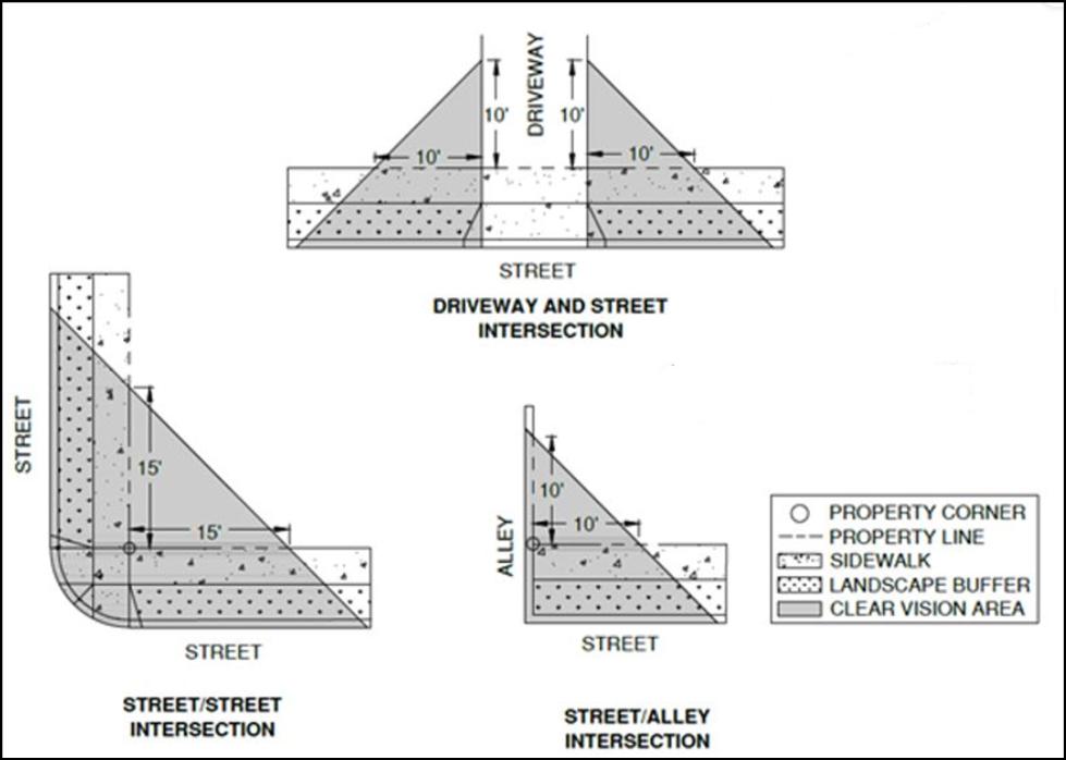
ILLUSTRATION – STREET TO STREET CLEARVISION AREA
1. Curb Painting. Curbs within clear vision areas shall be painted yellow when any of the following exist or are proposed:
A. A commercial, industrial, or mixed-use development is proposed adjacent to a residentially-zoned area;
B. Intersections of local roadways intersecting collector or arterial roadways; and
C. Clear vision areas for which curb painting is deemed necessary by the City Engineer.
D. Exceptions. Curbs shallnot be painted yellow:
1. In the Downtown Overlay District, or
2. Wherecurb extensions exist or are proposed.
[Section 8.0305 amended by Ord. #2020-15 passed November 10, 2020]
[Section 8.0305 amended by Ord. #2023-07 passed December 19, 2023]
8.0310Exceptions to Clear Vision Areas. The following are exempt from compliance with the clear vision area standard:
1. Utility post or column;
2. Tree trunk (clear of branches or foliage up to eight feet from curb height);
3. Telephone or power poles;
4. Plants less than three feet tall; and
5. Utility boxes or pedestals less than three feet tall.
[Section 8.0310 amended by Ord. #2023-07 passed December 19, 2023]
8.0315Construction or Alteration of Gas or Card-lock Stations. Any gas or card-lock stations which are constructed or undergo major alteration subject to the parameters of RDC sections 8.3005 and 8.3010 shall conform as follows:
1. Minimum lot size for gas or card lock stations:
A. The minimum lot size for station sites shall be 10,000 square feet on a corner lot and 12,000 squarefeet on any other lot.
B. The minimum street frontage on a corner lot shall be 100 feet.
C. The minimum street frontage for station sites on other than a corner lot shall be 120 feet.
D. The minimum lot depth shall be 100 feet.
8.0320Gas, Card-Lock, or Fuel Container Abandonment. Any change of use proposed for any facility containing underground or above ground fuel containers shall provide verification from DEQ that all tanks have been removed or have been disabled and decontaminated. Verification of removal and/or decontamination shall occur prior to any building permit being issued for construction or for a change of use.
[Section 8.0320 amended by Ord. #2020-15 passed November 10, 2020]
8.0321Canopy Standards. For any use or structure proposing an overhead canopy, the following standards shall apply:
1. Definition. A permanent roofed structure which may be free- standing or partially attached to a building for a purpose of providing shelter to patrons in automobiles, and patrons on foot, but shallnot mean a completelyenclosed structure.
2. Setbacks. Canopy setbacks shall be measured from the edges of the canopy structure closest to the respective property lines and shall meet the setback requirements of the underlying zone, with the exception of, the C-2 zone where there are no required setbacks. The canopy structure shall be set back not less than 10 feet from any property line.
3. Lighting. All lighting directly or indirectly associated with a canopy shall be recessed from direct view from any public or private road, and from all neighboring properties.
4. Stacking Distance. See RDC section 8.0322, “Stacking Room”.
[Section 8.0321 amended by Ord. #2020-15 passed November 10, 2020]
8.0322Stacking Room. For any use that has drive-up service, the following shall apply.
1. Car length. For this purpose, acar lengthis deemed to be 20’.
2. Standards. The following shall apply to all on-site stacking room, which is required for any type of drive-up service:
A. For any single window, gas pump, or other drive up use that is singular in nature (other than espresso stands or fast-food pickup windows) requiring one drive aisle, the minimum stacking room including the pickup location shall be 5 car lengths.
B. For two or more pick up windows, gas pumps, or other drive up uses, the minimum stacking room shall be 4 car lengths for each window, pump, or similar use.
C. For any fast-food use (excluding espresso stands), the required stacking room per drive up window is 7 car lengths.
D. The required stacking room for any espresso stand, coffee kiosk, or similar use, is 3 car lengths per pickup window.
E. Any use that is not identified herein shall incorporate the minimum standard (5 car lengths), or city staff may at their discretion allow for reduction in the amount of required stacking room with the finding that the use will not require the minimum stacking distance.
F. At no time shall stacked cars conflict with any required parking, on-site access, or required loading / unloading area on or adjacent to the site.
G. Any proposed stacking area immediately adjacent to any residence shall incorporate a 6’ tall solid wall as a sound barrier between the commercial use and residence.
[Section 8.0322 amended by Ord. #2020-15 passed November 10, 2020]
8.0323Minimum Standards for the Construction or Alteration of a Detached Accessory Structure (non-dwelling).
1. The maximum lot coverage for any accessory structures requiring a building permit shall be no more than a total of 35% of the lot size. A Conditional Use Permit is required for the construction of any accessory structure or garage which is over 1,500 sq. ft. or over 80% of the size of the residence, whichever is less.
2. Any accessory structure other than the vehicular opening of a garage shall be set back at least 5feet from any property line, except as otherwise required by clear vision.
3. Accessory structures requiring a building permit shallmeet all solar requirements.
4. Detached accessory structures shall not be located in any required front or side yard setback.
5. Vehicle entrances into detached garages or carports shall be set back no less than 20’ from any alley.
8.0325 Accessory Dwelling Units and Guest Houses. Accessory Dwelling Units (ADU’s) and Guest Houses, when allowed in the underlying zone, are permitted subject to the following. The terms “accessory dwelling unit” and “guest house” are used synonymously herein except for the size limitations and are listed as separate and distinct uses in Section 8.0135, Table A; guest houses shall not contain kitchens.
1. Development Standards.
A. The size of a stand-alone accessory dwelling unit shall be no less than 300 square feet in gross floor area and no more than 900 square feet in gross floor area. Guest houses shall be no less than 300 square feet in gross floor area and no more than 1200 square feet in gross floor area.
B. ADU Setbacks and Height:
*Theaccessorydwellingunitcannotbelocatedinfrontoftheforward-mostfaçadeoftheprimary dwelling.
**Deviationfromrearsetbackmaybegrantedadministrativelyifacceptableoff-streetparkingis providedforonevehicleandnoticeisprovidedtoAffectedPersonsperSection8.1310and8.1335.B.
C. If the accessory dwelling unit is located above a garage, the ADU may not exceed thefootprint of the garage.
2. An accessory dwelling unit must be able to function as a separate dwelling unit. This includes the following:
A. The accessory dwelling unit must be separately accessible from the exterior. An interior entrance to the primary residence may be approved, pursuant to review and acceptance by the Community DevelopmentDirector, or designee;
B. The accessory dwelling unit must have separately accessible utilities, unless served by the primary residence.
C. The accessory dwelling unit shallcontain a kitchen.
D. The accessory dwelling unit shallcontain a bathroom.
E. The accessory dwelling unit shall not be a Recreational Vehicle (RV) or portion thereof.
3. The finished floor height of an accessory dwelling unit shall be entirely above the natural or finished grade, whichever is higher, on all sides of the structure.
4. An accessory dwelling unit shall be located within the dimensional requirements of the zone district in which the property is located and cannot be located in front of the forward-most façade of the primary dwelling.
5. If the entrance is accessed via stairs, a covered porch, or other sufficient means of preventing snow and ice from accumulating on the stairs shall be provided.
6. Accessory dwelling units shall be developed in accordance with the requirements of this title which apply to residential development in general. These include, but are not limited to, all applicable International Building and Fire Code requirements related to adequate natural light, ventilation, fire egress, fire suppression, and sound attenuation between living units. This standard may not be varied.
[Section 8.0325 amended by Ord. #2016-17 passed January 31, 2017]
[Section 8.0325 amended by Ord. #2020-15 passed November 10, 2020]
[Section 8.0325 amended by Ord. #2022-04 passed June 28, 2022]
[Section 8.0325 amended by Ord. #2022-09 passed December 13, 2022]
[Section 8.0325 amended by Ord. #2023-07 passed December 19, 2023]
8.0330Exterior Lighting.
1. Purpose. The purpose of this code section is to allow residents, businesses, and public entities to adequately illuminate the outdoor areas on their property without adversely impacting the use of adjacent property and minimizing the impact on Redmond’s dark skies.
2. Applicability. The provisions of this code section apply to all outdoor lighting, including security lighting in all zones, unless exempted under this code section. All outdoor lighting subject to this code section shall comply with these requirements. This includes, but is not limited to, new lighting, replacement or repair of existing nonconforming lighting, and any other lighting whether attached to structures, poles, the earth, or any other location that illuminates exterior areas of the property. It is the property owner’s responsibility to ensure compliance with this code section, including lighting installed by a third party or prior property owner.
3. Requirements for Lighting Regulated by this Code Section
A. All lighting shall be downcast and use a shielded fixture or other means to limit up lighting. The terms “downcast and shielded” mean that the fixture allows no light emission above a horizontal plane through the bottom of the fixture. See illustration A which illustrates downcast lighting and up lighting.
B. Lighting shall not shine into neighboring residences, or onto public streets.
C. Lighting in the canyon or within 25’ of the canyon rim shall be submitted to and reviewed by the Community Development Director or Planning Commission prior to installation for compliance with this code section.
4. The following shall be exempt from the provisions of this code section:
A. City approved lighting within public right-of-way or easement for the principal purpose of illuminating streets, roads, and street signs.
B. Lighting for public facilities including but not limited to, City Hall, public monuments, public art, public parks, and public landscaping.
C. All lighting at the Redmond Municipal Airport.
D. All lighting at the Deschutes County Fairgrounds.
E. All lighting for public schools, except that sport field lighting shall be turned off within one hour of the end of the event or game.
F. All lighting of buildings designated as historic by the City of Redmond.
G. Sign lighting that is otherwise regulated by the provisions of the City of Redmond Sign Code.
H. Temporary lighting for theatrical, television, performance areas and construction sites as approved by theCommunity Development Department.
I. Underwater lighting in swimming pools and other water features.
J. Emergency lighting that is only used under emergency conditions and other lighting being used during police declared emergency.
K. Lights used for holiday decorations.
L. Motion detector lights that operate automatically for periods of less than ten minutes.
M. Lighting of flags for the United States, State of Oregon, POW, and City of Redmond.
N. Lighting required by federal or state laws or regulations.
O. Outdoor lighting fixtures lawfully installed prior to and operable on the effective date of this code section, and which are in compliance with the prior version of RMC 8.0330 may continue to be used as a nonconforming light fixture. Any repair, replacement, or relocation of outdoor light fixtures as of the effective date of this code section shall be subject to the provisions of this code section.
CHAPTER 8 DEVELOPMENT
IllustrationA:
Downcastmeans-
Anylightthatisnot“uplight”andislessthan90degreesdownfromthefixtureshieldasshown below.


[Section 8.0330 amended by Ord. #2018-12 passed November 13, 2018]
8.0335Development Standards Along the Perimeter of the Canyon.
1. The following rules apply to any development within 100 feet of the canyon rim:
A. Any dwelling or accessory structure shall be less than twenty-four (24) feet in height and setback at least twenty-five feet from the canyon rim;
B. No existing trees within 25 feet of the canyon rim, over 3" caliper measured 3 feet above ground level shallbe removed from the site or, if removed, are replaced by an equal number of tree(s) that are at least 2" caliper measured 3' above ground level;
C. Development shall maintain the natural appearance of the canyon rim; no alteration of the rock formation portion of the canyon rim is permitted;
D. No fence is constructedwithin ten (10) feet of the canyon rim;
E. All lots fronting on the canyon rim shall be a minimum of 9,000 square feet;
F. No deck, patio or structure requiring a building permit may be constructed within ten (10) feet of the canyon rim;
G. Lighting shall be met subject to 8.0330, “Exterior Lighting”.
2. A Conditional Use Permit is required for the following Development along Redmond Dry Canyon:
A. Any structure exceeding 24' height, or is locatedwithin 25’ of the canyon rim;
B. Any structure not governed by section (A)(1) located in a side or rear yard area adjacent tothe canyon rim.
C. Decks or patios shall be setback from the canyon rim the same number of feet as the height of the deck or patio from the ground.
[Section 8.0335 amended by Ord. #2016-17 passed January 31, 2017]
[Section 8.0335 amended by Ord. #2022-04 passed June 28, 2022]
8.0340Fences. All fences constructed shall comply with the following standards. For the purpose of these standards, fences refer to fences, lattice work, screens, or walls (other than a retaining wall). The intent of these standards is to ensure that fencing contributes positively to the appearance of the community and neighborhoods, and that the scale, location, and aesthetics of fencing does not adversely affect surrounding properties or public safety.
1. On all properties one (1) acre or less in size, in all Residential Zones (including residential uses in the C-2 Zone and in the Downtown Overlay District) and the Urban Holding Zone, all fences shall be developed to the following standards:
A. Fences abutting a local public street shall comply with the following:
1. Fences in front yards, and in that portion of side yards extending from the front property line to the front façade of the dwelling, shall be a maximum of 3½ feet tall.
2. On corner lots, only one front yard restriction is applied relative to the 3½ feet fence height restriction, in which case, the fence along the non-front yard designated side may be up to 6 feet tall from the front façade of the house back to the rear property line (see fence example in Figure1).
3. Fences in that portion of side yards extending from the front façade of the dwelling to the rear property line, and all rear yards, shall be a maximum of 8feet tall.
4. Fences located in side and rear yards shall incorporate architectural columns consisting of materials such as stone, brick, rock, wood, or other similar products, at each property corner along the fence that abuts the street. (See: Examples). The columns shall be a minimum of 12” x 12” in size.
5. Fences shall be constructed of wood, vinyl, or wrought iron. Chain link fences are not permitted. Other types of fence material, powder coating and construction may be approved by the Community Development Director, or designee, subject to conforming with the intent statement above.
6. Fences in side or rear yards which abut an alley shall be allowed to be 8 feet in height. (Note: the Oregon State Building Code – as defined in State Statute – indicates that fences in excess of 7 feet in height require a building permit andmay need to be professionally engineered).
7. Fences which encroach into the public right-of-way shall be treated as a nuisance and shall be subject to enforcement pursuant to Section 8.0805 of the City of RedmondDevelopment Code.
B. Fences abutting a collector or arterial street shallcomply with the following:
1. In addition to the requirements for fences abutting a local street, fences located in side and rear yards that abut a collector or arterial public street shall in addition incorporate a minimum 5” wide square column every eight (8) feet along the fence with a cap added to the top of each column that is a minimum of a ½” larger in each direction and a minimum of 1” in height.
C. Fences not abutting a public street shall comply with the following:
1. Fences located in the side or rear yards shall not exceed 8 feet in height. (Note: the Oregon State Building Code – as defined in State Statute –
indicates that fences in excess of 7 feet in height require a building permit and may need to be professionally engineered).
D. No fence in any residential zone, except as exempted by Section 8.0340(5), shall be constructed with barbed wire, razor wire, or similar apparatus.
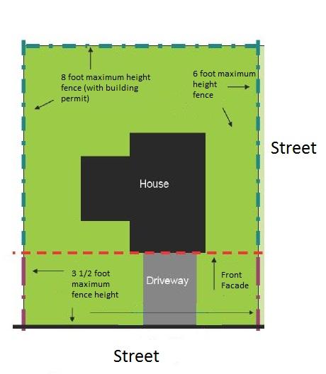
2. In all Commercial Zones (except for the C-2, Central Business District Zone, and the Mixed-Use Zones), the PF-Public Facility Zone, the Park Zone, and in any Industrial Zone, all fences shall be developed tothe following standards:
A. The maximum height of a fence shall not exceed 8 feet. (Note: The International Building Code indicates that fences in excess of 7 feet in height require abuilding permit and may need to be professionally engineered).
3. For any development undergoing land use review, any wood or vinyl fence bordering a street shall incorporate architectural elements in accordance with Section 8.0340(1)(A)(4) and/or (1)(B)(1) herein.
4. All fences, regardless of zone or location, shallcomply with the following requirements:
A. Fences fronting public streets shall provide one gate, opening, or other site access for emergency services use. For corner lots, only one opening along either the front or side yard frontage is required.
B. Fences shall comply with the clear vision standard in Section 8.0305.
C. Fences shall be constructed on private property and shall not be located in public rights-of-way.
D. Fences shall be comprised of wood, vinyl, metal, or other sturdy material that is able to be painted and/or maintained in structurally sound condition. All fences shall be free from exposed nails, screws, loose members, decaying materials, or other similar conditions that can pose a hazard.
5. The following fences shall be exempt from the standards set forth herein, except for the requirement to comply with the clear vision standard in Section 8.0305, as listed in Section 8.0340(4)(B) above:
A. Any security fencing around a public or quasi-public utility or entity including the Airport perimeter.
B. Fences related to a park or school use including (but not necessarily limited to) tennis courts, driving ranges and ballfields.
Figure 1 Corner Lot Fence Example
C. Fences necessary for compliance with any documented Federal or State mandated requirements (i.e., Homeland Security requirements)
D. Any fence exempted under (5)(A and B) herein that is in excess of 20 feet in height shall require conditional use permit review and approval, and a public hearing.
Examples:
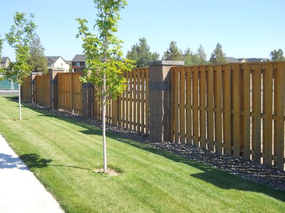
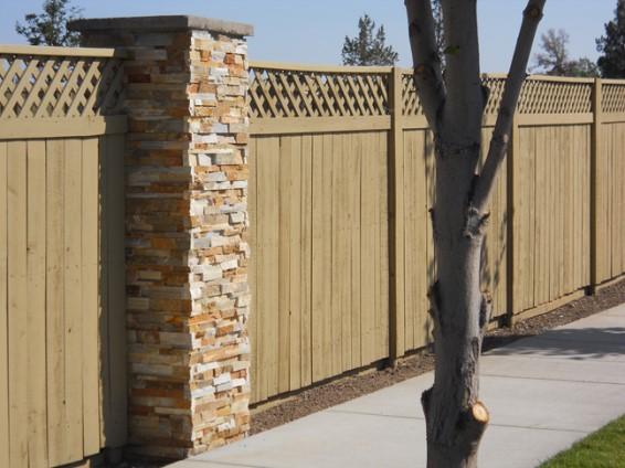
E. In the C-2and DOD zoning districts, fences shall comply with the following standards:
Track 1. Fences along street frontages and/or infront of a building shall be no taller than 4 ft. Fences shall be made of wood, wrought iron, powder coated chain-link, and shall be at least 75% transparent in composition. Proposals that do not fit the Track 1 provision shall be processed as a Track 2 application.
Track 2. As an alternative to the Track 1standards, fencing proposals must utilize alternative designs if they reflect the architectural theme of the buildng and site. They must also showhow the public is separated from the on-site activities in an aesthetic and practical manner. In no case shall fences betaller than 6feet in height.
[Section 8.0340 amended by Ord. #2013-04 passed May 14, 2013]
[Section 8.0340 amended by Ord. #2014-14 passed July 22, 2104]
[Section 8.0340 amended by Ord. #2016-17 passed January 31, 2017]
[Section 8.0340 amended by Ord. #2018-09 passed September 11, 2018]
[Section 8.0340 amended by Ord. #2020-15 passed November 10, 2020]
[Section 8.0340 amended by Ord. #2022-04 passed June 28, 2022]
[Section 8.0340 amended by Ord. #2022-09 passed December 13, 2022]
[Section 8.0340 amended by Ord. #2023-07 passed December 19, 2023]
8.0345Home Occupation. The purpose of a home occupation is to allow residents the opportunity to engage in a home-based business. Home occupations shall have characteristics that are indistinguishable from the residential use of a dwelling, or property, and do not infringe upon the rights of nearby residents. Meeting the criteria below shall be considered and permitted as uses accessory to the residential use of a dwelling.
1. The home occupation is to be secondary to the main use of the property as a residence. The home occupation can occur in the primary dwelling or in an accessory structure on the same property.
2. No structural alterations shall be allowed to accommodate the home occupation except when otherwise required by law, and then only after the plans for such alterations have been reviewed and approved by the City. Such structural alterations shall not detract from the outward appearance of the building as aresidence.
3. The home occupation must be conducted wholly within lawfully built enclosed structures and in such a manner as not to give an onward appearance of abusiness.
4. Outdoor storage, including but not limited to, inventory, supplies, or equipment, must be completely screened behind a sigh-obscuring fence or within an enclosed structure; stored products; equipment, or materials shall not be visible from the public right-of-way or adjacent properties or common area.
5. A home occupation is prohibited which is inconsistent with the residential use of the property or creates adverse impacts such as: noise, vibration, smoke, dust, odor, generation or addition traffic, or other factors.
6. No materials or commodities shall be delivered to or from the property which are of such bulk or quantity as to require delivery by a commercial vehicle or a trailer or the parking of customer's vehicles in a manner or frequency as to cause disturbance or inconvenience to nearbyresidents or so asto necessitateoff-street parking.
7. Exterior signs shall be limited to those permitted in the zone in which the home occupation is located. There shall be no other exterior indication of the home occupation.
8. Allows on-site one (1) business related vehicle or truck not exceeding 15,000 pounds gross vehicle weight and one (1) other non-motorized wheeled trailer, which shall not exceed 10,000 pounds gross vehicle weight. No commercial vehicle as defined in ORS 801.208, as amended, is permitted as part of a home occupation.
9. There shall be no retail sales from the premises.
10. Home occupation licenses are subject to City Cody Section 5.335 et seq governing nuisances and noise.
[Section 8.0345 amended by Ord. #2020-15 passed November 10, 2020]
[Section 8.0345 amended by Ord. #2022-04 passed June 28, 2022]
8.0350Design Standards for all Residential Structures and Sites fronting both public or private streets and alleys
1. The front doors and front facade of all primary dwelling units shall face a public or private street.
2. At least one yard facing a public or private street shall provide a gate, opening, or other access for emergency service use.
3. For all residential lots served by alleys and fronting a public or private street, addresses shall be clearly visible from the street rather than from the alley.
8.0360Placement of a Temporary Residence. A temporary residence may be placed on a site in conjunction with the issuance of a building permit for a period of six months following the date of issuance. A property owner may apply for a permit allowing such placement by filing an application with the Community Development Director on a form provided by the Planning Department. The Community Development Director shall issue said permit but may attach conditions deemed necessary to minimize the impact of the placements on the adjacent properties. The Community Development Director may also grant an additional six months for the permit if the applicant can establish the extension is necessary.
8.0362Placement of Temporary Residences for Medical Hardship. A temporary residence shall be allowed as an additional dwelling due to a medical hardship under the following restrictions:
1. The temporary residence shall be placed within 100 feet of the main dwelling.
2. The temporary residence shall be connected to the same sewage facility as the main residence where applicable.
3. The applicant shall renew the permit on an annual basis and the Community Development Director shall review permits issued at any time and may revoke the permits when they are found to not be needed for the original purpose.
4. The applicant shall provide a letter from a physician documenting the need for the temporary residence.
5. The temporary residence must be removed within 90 days after termination of the permit.
6. The temporary residence must meet all therequired setbacks.
7. If the temporary residence is visible from any adjacent property, site obscuring, screening shall be required.
8.0364Beekeeping. The purpose of this section is to regulate the keeping of bees on residential lots within the City of Redmond. This activity is considered to be an accessory use subject to the following standards:
1. Location, Density, andMaintenance of Colonies.
A. The number of colonies is limited to one (1) colony per legal lot of up to 5,000 sq. ft. of lot area, plus one (1) additional colony per each additional 5,000 sq. ft. of lot area, up to a maximum of eight (8) colonies regardless of lot size.
B. Colonies shall be located in the side or rear yard and set back no less than 10 feet from the nearest property line.
C. Hives shall be placed on property, so the general flight pattern of bees does not unduly impact neighboring properties or their inhabitants. If any portion of a hive is located within thirty (30) feet of a public or private property line, a flyaway barrier at least six (6) feet in height shall be established and maintained around the hive. The flyaway barrier shall be located along the property boundary or parallel to the property line, and shall consist of a solid wall, solid fencing material, dense vegetation or combination thereof extending at least ten (10) feet beyond the colony in each direction, so that all honeybees are forced to fly at an elevation of at least six (6) feet above ground level over the property lines in the vicinity of the colony.
D. Colonies shall be maintained in movable-frame hives with adequate space and management techniques to prevent overcrowding.
E. Every beekeeper shall maintain a supply of water for the bees located within 10 feet of each hive. The water shall be in a location that minimizes any nuisance created by bees seeking water on neighboring property.
F. Hives shall be actively maintained. Hives not under human management and maintenanceshall be dismantled or removed.
G. In any instance in which a colony exhibits unusually aggressive characteristics or a disposition toward swarming, it shall be the duty of the beekeeper to promptly re-queen the colony with another queen, or the colony will be destroyed.
[Section 8.0364 added by Ord. #2010-10 passedOctober 26, 2010]
8.0365Keeping of Livestock. The keeping of livestock shall be subject to the following limitations:
1. General provisions:
A. Livestock may only be kept on residentially zoned properties per RDC 8.0135.
B. Proper sanitation shallbe maintained at all timesper City Code 5.335.1.
C. All animal food shall be stored in metal or other rodent-proof containers.
2. Capacity:
A. The required area for horses, mules, donkeys, and similar shall be a usable area of 10,000 square feet for the first animal, 20,000 square feet for two animals, and 5,000 square feet for each additional animal thereafter.
B. Cows, goats, sheep, llamas, alpacas, and swine shall have a fenced corral or pasture with ausable area of at least 10,000 square feet per animal.
C. The number of fowl and rabbits allowed shall be four for the first 5,000 square feet of property and one additional animal for every 1,000 square feet of property thereafter.
3. Setbacks:
A. Fowl pens and coops shall be located on the rear half of the property not closer than 25 feet from any dwelling abutting the subject property.
B. Animal runs, barns, fowl pens, and coops shall be setback 10 feet from rear property lines and 15 feet from side property lines.
C. Animal runs, barns, fowl pens, and coops shall not be located closer than three feet to the exterior walls of the residential unit on the subject property.
D. Animal runs or barns for the enclosure of horses, cows, goats, sheep, swine, or other livestock shall not be located closer than 50 feet to a dwelling abutting the subject property.
4. Enclosures:
A. Animal barns, coops, and other related structures are subject to the provisions of RDC 8.0323, Minimum Standards for the Construction or Alteration of Detached Accessory Structure (non-dwelling).
B. Fences used for enclosing livestock shall be kept in good repair and be at least four feet in height. They must meet the minimum standards of RDC 8.0340, Fences.
C. Fowlmust be contained in a fenced pen or coop at all times.
5. Multiple Dwellings: In addition to the above criteria, livestock kept on properties containing multiple dwelling units must meet the following:
A. The property owner or designated property manager must provide written notification to all residents of each dwelling unit verifying the keeping of livestock on the property will comply with the requirements of this section prior to the keeping of said livestock.
B. Animal runs, barns, fowl pens, and coops shall be located at least 20 feet away from the exterior walls of any dwelling unit on thesubject property.
[Section 8.0365 amended by Ord. #2010-10 passed October 26, 2010]
[Section 8.0365 amended by Ord. #2018-09 passed September 11, 2018]
[Section 8.0365 amended by Ord. #2023-07 passed December 19, 2023]
8.0366Trans America Bike Route. No land use action or permit shall be allowed on adjacent lands to the Trans America Bike Route that will adversely affect the function of the bike route.
8.0367OSPR / “R” Zone Density Transfer Provisions.
1. All property within the North Redmond US 97 Interchange Area Management Plan (IAMP) area, and annexed to the City, shall be subject to a condition of development approval that stipulates the property shall:
A. Have immediate direct access to alocal public street other than a state highway,
B. Comply with the IAMP Local Street Connectivity Plan (Comprehensive Plan Addendum Chapter 9 Transportation Element figure 1); and
C. Relinquish all direct access rights to a state highway when a legal alternative access exists. (Amended by CityOrdinance 2007-9, June 9, 2007)
[Section 8.0367 amended by Ord. #2015-01 passed February 24, 2015]
[Section 8.0367 amended by Ord. #2016-17 passed January 31, 2017]
8.0370Building Setbacks for the Protection of Solar Access.
[Section 8.0370 amended by Ord. #2012-04 passed April 24, 2012]
[Section 8.0370 amended by Ord. #2020-15 passed November 10, 2020]
[Section 8.0370 deleted by Ord. #2022-04 passed June 28, 2022]
8.0370 Supportive Shelter Standards.
1. Applicability.
A. Any proposal for asupportive shelter which is identified as a qualifying emergency shelter under ORS 197.782 shall be reviewed for compliance with statelaw and approvedaccordingly.
B. See Use Tables 8.0135,8.0137, 8.0190, 8.0220 and 8.0260.
2. Review and Application. Supportive shelters shall be reviewed as a Development Action. An approved siteplan shall identify an appropriate timeline and process for periodic review and renewal. A complete application for a Support Shelter proposal shall include:
A. Pre-development. A completed Pre-development Application prior to submission.
B. Site plan. A site plan which demonstrates compliance with standards of this section.
C. Lease or Legal Use Agreement. A copy of the lease document or equivalent that outlines the legal agreement between the applicant and the property owner to use the subject property for the supportiveshelter proposal, if the applicant is not the property owner.
D. Financial Security Proposal. Proof of financial security in compliance with 6(D) of these standards.
E. Operating Plan. A planoutlining and identifying the operations, security,and case management services.
G. Narrative. A narrative explaining the supportive shelters compliance with these standards. This includes a description of themanaging agency, the nameand contact information of the designated contact person from themanaging agency, and a copy of the draft Code of Conduct that would be provided to authorized shelter residents.
3. Shelter Unit. A shelter unit provides shelter from the elements. Shelter units are not dwelling units, and no structure that could meet building code as a dwelling unit shall be used as a shelter unit. Shelter units shall obtain allbuilding permits determined to be necessary by the Building Official and may not contain natural gas appliances, propane heaters, or generators.
Shelter Unit Types:
A. Tents, yurts, and membrane or fabric structures,as per ORS197.746.
B. Recreational Vehicles or other privately owned Vehicle (as defined by Section 5.325 of City Code).
C. Site-built, modular, or prefabricated structures, or similarly built structures, which do not contain permanent provisions for cooking.
4. Development Standards.
A. Height and Setbacks. Building height and setback standards of the underlying zone shall apply to any supportive shelter site.
1. Setback standards shallonly be applied topermanent structures, such as common area buildings.
2. No shelter units regardless of type may be sited closer than tenfeet to any public right-of-way.
B. Density. No supportiveshelter site shall exceed a density of 25 shelter units per net acre.
5. Site Layout and Characteristics.
A. Proximity and Spacing. Shelter units of various types may be collocated, provided they are clearly delineated, and development standards are met. Shelter units must be sited with adequate separation between shelter types and units to provide for safety and privacy. Spacing willvary depending on sheltertype, fire-separation requirements, ADA compliance, emergency egress pathways, and emergency access for first responders.
B. Parking. Parking areasshallbe provided for useby shelter residents, staff, and visitors pursuant to Section 8.0500 through 8.0515 (Off-Street Parking and Loading Requirements). Additional spaces shall be provided for authorized shelter residents using privately owned vehicles as shelter units. Parking shall be approved based on capacity proffered by managing agency providing services.
C. Storage. No outdoor storage is permitted, excluding bicycles or similar mobility devices, except as provided in a designated andapproved storage area. Residents shall be provided with enclosed, secure storage for their belongings.
D. Fencing. The supportive shelter site shall be fenced and screened from sight except at entry and exitplaces. The fencing and screening shallbe no less than six feet in height and shall be maintained. The Community Development Director may allow for deviations or reduced fencing or screening standards.
E. Signage. A sign must be posted withthe name and phone number of the managing agency. This sign is exempt from sign standards but must be posted at the entranceto the supportive shelter site and shallnot be illuminated or exceed six square feet in size.
F. Common area facilities. Common areas for use by the authorized shelter residents and staff shallbe provided to ensure adequate trashand recycling services. At least one toilet and hand-washing station shall be provided and
maintained. These common areas may provideaccess to water, sanitation, laundry, cooking, warming or cooling areas, through permanent or temporary facilities. The Oregon Health Authority may require public health best practices for shared health and sanitation facilities. Common areas may also befurnished with facilities needed by the managing agency to provide other supportive services, such as case management, counseling, daycare, kennel space, skill development, or similar.
G. Compliance. The layout of the supportive shelter site and all structures shall comply with any applicable Federal, State, and local requirements, including but not limited to Fire, Environmental Health, Building, and Engineering requirements and will not pose any unreasonable risk to public health or safety.
1. Ensure units and support structures are accessible in accordance with the Americans with Disabilities Act of 1990 (ADA), as amended and in accordance with the City of Redmond Building Code.
6. Site Management. An approved supportive shelter sitemust be actively managed and maintained by amanaging agency in order to operateand serve shelter residents. A shelter site that is not being actively managed or maintained by a managing agency for a period of six or moremonths will be considered to be an abandonment ofthe useunless an extension or another approval is obtained. A shelter site found to be operating without being actively managed and maintained by amanaging agency will be considered tobe in violation of this section.
A. ManagingAgency. The managing agency may be any governmental, housing authority, nonprofit, religious agency or public benefits corporation (as defined in ORS 65.001). The managing agency must have adesignated contact person and their contact information must be kept up to date for the City’s use and reference.
B. Active Management and Maintenance. A managing agency can demonstrate active management and maintenanceof the supportive shelter site by having a local or on-site presence and being available to accept and respond to telephone calls during business hours and to any potential after-hours emergency.
1. Supportive Services. A managing agency mustbe providing supportive services to each authorized shelter resident for the entire duration that the shelter has residents. Staff must be ableto assist residents in obtaining necessary documentation, suchas government identification and vehicle registration and insurance. Additional on-site services may include case management services for housing, financial, vocational, educational, physical or behavioral health care, public benefits, and any other similar services incidentalto shelter.
C. Code of Conduct. The managing agency shall not authorize ashelter resident without providing each resident with acode of conduct form to review andsign. The managing agency has the righttorefuse entry or discontinue use for any individual. The code of conduct shall be written in a language understandable to the resident and shallcontain policies and information that set out regulations regarding:
1. How individuals who may stay on the premises will be selected.
2. How many days someone may stay on the premises.
3. Supervision and identification of the supportive services or case management tobe provided.
4. What structures or other items may be placed or stored on the premises.
5. Conduct, noise disturbance, pets, location and expected use of all common area facilities, and visitation.
6. Prohibition of openflames on the premises, or within vehicles unless contained in a Recreational Vehicle (RV) currently titled and registered with the State of OregonDepartment of Motor Vehicles.
7. Other information or policies the managing agency feels necessary to include.
D. Financial Security. Themanaging agency at thetime of application shall provide a financial security proposal to ensure the removal of the improvements should the shelter site approval expireor become void. This may be in the form of abond, petition, cash, or other adequate method. The financial security itself shall be provided totheCity and secured beforethe shelter site may begin operation, or else the operation of the supportiveshelter will be considered to be in violation of this code.
E. Enforcement.
1. Approval of a supportiveshelter site shall not be construed to abrogate or limit the jurisdictionorauthorityoftheRedmondPoliceDepartmentorany otherlawenforcementagency. Notwithstandinganyother provisionof this section or City Code, the City Manager or designee may:
A. Revoke authorization of a supportive shelter site for violations of the requirements of thissection.
B. Prohibit a supportive shelter site on a property if the City finds that any activity related tothe shelter site on that property constitutes a nuisance or other threat to the public welfare.
2. Nothing in this section of this code creates any duty on the part of the City or its agents to ensurethe protection of persons or property with regardto permitted supportive shelter sites.
[Section 8.0370 added by Ord. #2023-07 passedDecember 19, 2023]
8.0375Manufactured Home Park Standards. Manufactured Home Park. A manufactured home park shall be built to site standards in effect at the time of construction and shall comply with the following additional provisions.
1. Evidence shall be provided that the park will be connected to City sewer and water services.
2. The space provided for each manufactured home shall be provided with City water, electrical, and sewerageconnections.
3. The number of manufactured homes shall not exceed the maximum density permitted in the underlying zone.
4. A manufactured home shall not occupy more than 40 percent of the contiguous space provided for the exclusive use of the occupants of the manufactured homes and exclusive of space provided for the common use of tenants, such a roadway, general use structures, parking spaces, walkways, and areas for recreation and landscaping.
5. No manufactured home in the park shall be located closer than 15 feet from another manufactured home or from a general use building in the park. No manufactured home accessory building shall be closer than 10 feet from a manufactured home space or
other building or structure. No manufactured home or other building or structure shall be within 25 feet of a public street property boundary or 10 feet of another property boundary.
6. A manufactured home permitted in the park shall meet the following standards as determined by an inspection by the Building Official:
A. It shall have a State insignia indicating compliance with Oregon State Manufactured Home Construction Standards in effect at the time of the manufacture and including compliance for reconstruction or equipment installation made after manufacture.
B. Notwithstanding deterioration which may have occurred due to misuse, neglect, accident, or other cause, the manufactured home shall meet the State standards for manufactured homeconstruction evidenced by the insigne.
C. It shall not contain less than 225 square feet of space as determined by measurement of the unitexclusive of any trailer hitch device.
D. It shall contain a water closet, lavatory, shower or tub, and a sink in a kitchen or other food preparation space.
E. A manufactured home permitted in the park shall be provided with a continuous skirting.
7. There shall be no outdoor storage of furniture, tools, equipment, building materials or supplies belonging to the occupants or management of the park.
8. If the park provides space for 50 or more manufactured home units, each vehicular way in the park shall be named and marked with signs which are similar in appearance to those used to identify public streets. A map of the named vehicular ways shall be provided tothe fire department.
9. If a manufactured home space or permanent structure in a park is more than 500 feet from a public fire hydrant, the park shall have water supply mains designed to serve fire hydrants and hydrants shall be provided within 500 feet of such space or structure. Each hydrant within the park shall be located on vehicular way and shall conform in design and capacity tothe public hydrants in the City.
10. Open Space. A minimum of at least 2,500 square feet plus 150 square feet per manufactured home space shall be provided for recreation area. Recreation areas shall be improved with surfacing, facilities suitable for recreational use, or landscaping. No recreation facility created within a manufactured home park wholly to satisfy the requirements of this section shall be open to, or offered in itself, to the general public. The Community Development Director, or designee, may require the recreation area to be centrally located within the park and physically separated from streets or parking by a fence that complies with fence regulations.
11. Parking Space Requirement. Two parking spaces shall be provided for each manufactured home space on the site. In addition, guest parking spaces shall also be provided in every manufactured home park within 200 feet of the manufactured home spaces served and at a ratio of one parking space for each two manufactured home spaces. Parking spacesshall have durable and dustless surfaces adequately maintained for all-weather use and shallbe properly drained.
12. All manufactured home parks over 10 acres in size shall be located to have access on a street designated as a collector street unless otherwise approved by the Community Development Director, or designee.
13. All manufactured home parks containing a total site area of 20 acres or more shall provide a secondary access to the mobile home park. Such secondary access shall enter the public street system at least 150 feet from the primary access.
14. Lighting shall be installed along the access ways of the manufactured home park and the recreation area with lights of 100 watts or better or not over 100 feet apart. Wires for service to light poles and trailer spaces shall be underground.
15. Roadways within the park shall be paved and shall not be less than 30 feet in width if parking is permitted on the margin of the roadway, or less than 24 feet in width if parking is not permitted on the edge of the roadway and an adequate designated area is provided and improved for guest parking and tenant recreational vehicles (such area shall be designed and improved to provide not less than one parking space per each two unit spaces in the park).
16. No manufactured homepark shallbe created on a site of lessthan one acre.
17. Sidewalks or other approved surfaced pedestrian walkways shall be provided.
[Section 8.0375 amended by Ord. #2020-15 passed November 10, 2020]
[Section 8.0375 amended by Ord. #2022-04 passed June 28, 2022]
[Section 8.0375 amended by Ord. #2023-07 passed December 19, 2023]
8.0380Temporary Use Permit (TUP).
1. Purpose. The purpose of this section is to establish regulations for uses that are temporary in nature.
2. Intent. The intent of this section is to ensure that the temporary uses do not adversely impact the long-term uses of the same or neighboring sites or impact the general health, safety, and welfare of persons residing within the community.
3. Applicability. Temporary uses are characterized by their short-term or seasonal nature and by the fact that permanent changes are not made to the site. These provisions place restrictions on the duration of the temporary use, its location, and other development standards.
4. Approval. Approval may be granted for structures or uses which are temporary or seasonal in nature, such as: temporary real estate offices, construction trailers and construction offices, and Mobile Food Units. Temporary uses must also comply with other provisions of this Code, or other required City, County, or State permits.
A. These provisions do not apply to:
1. A Mobile Food Unit place within a Mobile Food Pod.
2. A Mobile Food Vendor on private or public property.
B. A Mobile Food Unit shall obtain a valid City business license and operational permit from Redmond Fire and Rescue.
5. Application and Fee. An application for a temporary use shall be filed with the City and accompanied by the fee as specified in the City fee schedule.
6. Permit Approval. A TUP may be authorized by the Community Development Director, or designee, provided that the applicant submits a narrative and detailed site plan that demonstrates that the proposed use:
A. Generally conforms to the standards of the zone in which it is located.
B. The proposed use will not adversely affect adjacent structures and uses of the surrounding neighborhood.
C. The proposed use will not adversely affect the circulation and flow of vehicular and pedestrian traffic in the immediate area.
D. The proposed use will not create a demand for additional parking which cannot be met safely and efficiently in existing parking areas.
E. The proposed use will not conflict with the terms or intent of any other use permit, of any type, currently in effect on the property.
F. The proposed use will comply with applicable noise, odor, nuisance, fire code and other provisions of this Code and not be detrimental to the public welfare of the community.
G. Meets allapplicable Building Code requirements.
H. Is not located in the right-of-way, unless otherwise approved by the City Engineer. Construction trailers, trash receptacles, Conex boxes or other similar structures may not be places upon paved public roadways.
7. Time Limits. Temporary uses may be issued a permit for up to one year to accommodate the duration of the proposed use. The temporary use or structure shall be removed upon expiration of the TUP.
8. Conditions. Reasonable, clear, and objective conditions may be imposed in connection with the TUP as necessary to meet the purposes and intent of this section. Guarantees and evidence may be required that such conditions will be or are being complied with. Such conditions may include, but are not limited to:
A. Special setbacks and spaces.
B. Fences and walls.
C. Control of points of vehicular ingress and egress.
D. Special provisions for signs.
E. Maintenance of landscaping, weeds, litter, debris, and dust.
F. Control of noise, vibration, and odors.
G. Limitation of operational hours for certain activities.
H. A timeperiod within which the proposed use shall be developed.
I. A timelimit on total duration of temporary use.
9. Revocation. Any departure from approved plans not authorized shall be cause for revocation. Furthermore, if in the Community Development Director’s, or designee, determination, a condition, or conditions, of TUP approval are not or cannot be satisfied, the TUP approval, or building and occupancy permits, shall be revoked.
10. Extension. Not less than ten days before expiration, a request for a one-time extension of atemporary usefor an additional period maybe considered.
[Section 8.0380 added by Ord. #2022-04 passedJune 28, 2022]
[Section 8.0380 amended by Ord. #2022-09 passed December 13, 2022]
[Section 8.0380 amended by Ord. #2023-07 passed December 19, 2023]
8.0385Neighborhood Meeting.
1. Purpose and Intent. The purpose of the neighborhood meeting is to provide a forum for the applicant, surrounding neighbors, and interested members of the community to meet and consider a proposed land use application, and to discuss issues/concerns regarding the proposal prior to application submittal. Neighborhood meetings encourage citizen participation early in the development process, and an opportunity to revise the land use application to address the issues prior to application submittal.
2. Applicability. Neighborhood meetings are encouraged prior to submitting any land use application. The following application types or development proposals shall be subject to the neighborhoodmeeting requirements:
A. Master Development Plans.
B. Residential or mixed use development proposals that generate 200 or more daily trip ends, or 20 or more p.m. peak hour trip ends, where a Transportation Impact Analysis (TIA) is required.
C. Wireless and Broadcast Communications Facilities.
3. Requirements and Procedures. The neighborhood meeting must be held after a predevelopment meeting with City Staff, but before submittal of a land use application. The applicant shall be required to hold only one meeting prior to submitting an application for a specific site but may hold more if desired. If the development proposal is revised after the neighborhood meeting, and a major modification is requested, a second neighborhood meeting with a new notice shall be required before the revised application is submitted.
A. Location andTime. Neighborhood meetings shall be held in person at a location in reasonable proximity to the subject site. The meeting shall be held at a location open to the public., City Staff, and at a facility that is ADA accessible. The meeting shall be held on a weekday evening, or weekends at any reasonable time. Applicants may provide a virtual component for participants to join in the meeting. The virtual component shall not be done in lieu of the inperson requirements. ADA accommodations when requested by attendee must be provided.
B. Notice – Mail. Mailed notice of the meeting shall be provided by the applicant to the neighboring property owners (within 750 feet outside city limits and 250 feet within city limits) and the Community Development Department between ten and 30 calendar days prior to the meeting. Notices must be sent first class and shall include the date, time, and location of the meeting, as well as a brief description of the development proposal and property location. The description shall take into consideration information provided by City staff at the pre-development meeting, include project contact information, a copy of the tax map or a GIS map that clearly identifies the location of the proposed development, and a conceptual site plan.
C. Notice – Signage. The applicant shall also post notice of the neighborhood meeting on the subject site or on an access easement to the site within clear view of a public street at least seven days in advance of the meeting. The sign must display the meeting date, time, and address as well as project contact information.
D. Meeting Requirements. The developer must provide a sign-in sheet for attendees to provide their name, address, telephone number, and email address. At the meeting, the applicant shall provide a conceptual site plan and describe the major elements of the proposal. Depending on the type and scale of the particular application, the applicant should be prepared to discuss proposed land uses and densities; traffic impacts; proposed building size and height; proposed access and parking; and proposed landscaping, buffering and/or protection of natural resources as applicable. Attendees will have an opportunity to speak at the meeting and may identify any issues that they believe should be addressed. If no one arrives within 30 minutes of the scheduled start time for the meeting, the applicant may close the meeting and this requirement will be considered met upon the applicant’s submittalof the documentation to that effect.
E. Materials Submitted with Application. The neighborhood meeting notes that identify the major points discussed about the development, list of parties notified, signed affidavits of mailing and posting notices, copies of all materials provided by the applicant, and a signature sheet of attendees shall be included with the development application upon submittal.
F. Validity Period. The land use application shall be submitted to the City within 180 days of the neighborhood meeting. If an application is not submitted in this timeframe, the applicant shall be required toholda new neighborhood meeting.
CHAPTER 8 DEVELOPMENT REGULATIONS
G. Denial. Failure of the applicant to hold a neighborhood meeting in accordance with these provisions prior to submittal of a land use application shall result in an incomplete application and the application may be rejected.
[Section 8.0385 added by Ord. #2022-09 passedDecember 13, 2022]
WIRELESSAND BROADCAST COMMUNICATIONS FACILITIES
8.0400Title. The City of Redmond Wireless and Broadcast Communication Facility Standards are contained in Sections 8.0400 through 8.0450herein inclusive.
[Section 8.0400 deleted by Ord. #2011-13 passed November 8, 2011]
[Section 8.0400 added by Ord. #2011-13 passedNovember 8, 2011]
8.0405Purpose
and Applicability.
1. Purpose. The purposeof these standards is toprovide reasonable and necessary regulations for the erection of wireless and broadcast communication facilities in order to:
A. Implement an application process for the review and permitting of facilities.
B. Minimize the visual impacts of suchfacilities through careful design, siting, and screening.
C. Allow for the reasonable siting of facilities necessary to meetthe functional requirements of the wireless and broadcast industries and the public and private utilities, including conformance with the guidelines and intent of federal law and the Telecommunications Act of 1996.
D. Provide for the reasonable siting of non-commercial transmitting and receiving antennas for the recreational benefits of the citizens.
E. Promote and encourage, whenever practicable and whenever possible, the sharing and/or co-location of facilities among service providers.
F. Promote and encourage, whenever possible, the placement, height and quantity of facilities in such a manner, including but not limited to the use of stealth technology, tominimizeadverse aesthetic and visual impacts on the land, property and buildings adjacent to, surrounding, and in generally the same area as the requested location of such facilities, which shall mean using the least visually and physically intrusive facility that is not technologically or commercially impracticable under the facts and circumstances.
G. Avoid potential damage to adjacent properties from tower failure through proper engineering and careful siting of towers.
H. Protect the functions and safety of the RedmondMunicipal Airport by adherence to Federal Aviation Regulations (FAR) Part 77, Oregon Aeronautics Division’s Administrative Rule 738-70-010 through 738-70-260, “Physical Hazards toAir Navigation”, and the Redmond Airport Master Plan.
2. Applicability. This Section applies to the development, siting, and installation of wireless and broadcast communication facilities, including but not limited to cellular telephone facilities, broadband internet facilities, and radio and TV broadcasting facilities. This Section in no way prohibits, restricts, or impairs the installation, maintenance, or use of video antennas (including direct-to-home satellite dishes, TV antennas, and wireless cable antennas) used by viewers to receive video programming signals from direct broadcast facilities, broadband radio service providers, and TV broadcast stations.
[Section 8.0405 deleted by Ord. #2011-13 passed November 8, 2011]
[Section 8.0405 added by Ord. #2011-13 passedNovember 8, 2011]
[Section 8.0405 amended by Ord. #2020-15 passed November 10, 2020]
8.0410Definitions. The following words and phrases used in this Chapter, which supplement the definitions found in Section 8.0020 and elsewhere in this Code, shall have the following meanings:
Abandoned facility means a wireless and broadcast communication facility, including the telecommunications tower, where the usethereof has been discontinued for more than ninety (90) days.
Alternative tower structure means any existing building or other structure that is able to be used to support communication and broadcast equipment, including but not limited to light poles, utility poles, steeples, etc., but not including camouflaged or stealth towers constructed for the specific purpose of supporting communication and broadcast equipment. For the purposes of this definition, an alternativetower structure shall include all attached elements necessary to/for the structural integrity of the alternative tower structure.
Antennameans any system of wires, poles, rods, reflecting discs or similar devices designed for telephonic, radio, facsimile, data, or television communications through sending and/or receiving of electromagnetic waves when such system is either external to or attached tothe exterior of a structure. Antennas shall include, but not be limited to, devices having active elements extending in any direction, and directional beam-type arrays having elements carried by and disposedfrom a generally horizontal boom that may bemounted up androtated through a verticalmast or tower interconnecting the boom and antenna support, all of which elements are deemed to be part of the antenna. Antennaheight means the vertical distance measured from the ground surface at grade to the tip of the highest point of the antenna on the proposed structure.
AntennaSupport means any pole, telescoping mast, tower, tripod, or any other structure that supports adevice used in the transmitting and/or receiving of electromagnetic waves.
Breakpoint means the height at which atower is structurally designed to collapse and fall within a predetermined radius.
Broadcast communication facility means any facility that transmits radio or television signals including, but not limited to, antennas, dish antennas, microwave antennas, and other types of equipment for the transmission of such signals, including towers and similar supporting structures, equipment cabinets or buildings, parking areas, and other accessory development. This definition does not apply to Amateur Radio Stations as defined by the Federal Communications Commission, Part 97 of the Commission’s Rules.
Camouflaged means any wireless or broadcast communication facility that is designed to blend intothe surrounding environment. Examples of camouflaged facilities may include architecturally screened roof-mounted antennas, building-mounted antennas painted to matchthe existing structure, antennas integrated into architectural elements, towers made to look like trees and antenna support structures designed to look like flag poles or light poles.
Collocation means locating wireless or broadcast communication equipment from more than one provider on a single support structure, including an increase in height of an existing tower or alternative tower structureto allow installation of such additional wireless communication or broadcast facility equipment.
Enclosure means an area, fenced or otherwisedelineated, around the perimeter on which the equipment building, shelter, cabinet or other ancillary facilities are located.
Equipment building, shelter, cabinet or structure means a free-standing cabinet, shelter, building, or other structure used primarily to house equipment used by wireless or broadcast communication providers at a facility.
FAA means Federal Aviation Administration.
FCC means the Federal Communications Commission.
Façade mounted antenna means an antenna architecturally integrated into the façade of abuilding or structure.
Facility, as used in thisChapter, is inclusive of all of the elements of wireless or broadcast communication facilities, as they maybe more specifically defined herein.
Guyed tower means a wireless or broadcast communication tower that is supported, in whole or in part, by guywires and ground anchors.
Height means, when referring to a tower or structure, the distance measured from the pre-existing grade level to the highest point on the tower structure, even if said highest point is an Antenna, light, or lightning protection device.
Lattice tower means a guyed or self-supporting three or four sided, open, steel frame support structure used to support wireless or broadcast communication equipment.
Maintenance means emergency or routine repairs or replacement of transmitters, antennas, or other components of previously approved wireless telecommunication facilities which do not create a significant change in visual appearance or visual impact.
Microcell means low powered antennathat provide additional coverage and capacity where there are high numbers of users within urban and suburban macrocells, and are mounted at street level, typically on the external walls of existing structures, lampposts, and other street furniture.
Monopole means a wireless or broadcast communication facility consisting of a single pole constructed for purposes of supporting one or more antennas without guy wires or ground anchors.
Neighborhood character means those unique attributes including, but not limited to, architecture, historical and culturalfeatures, historical development patterns, landscape, hardscape, and the size, scale and spacing of buildings and other structures that define a neighborhood’s identity.
New Wireless and Broadcast CommunicationFacility means any newly constructed or installed wireless or broadcast communication facility whether or not it uses an existing telecommunication tower, an alternative tower structure or any modification of an existing wireless or broadcast communication facility, except for those collocations that are exempt from land use review under Section 8.0425 (2) of this code and those structures or activities exempted under Section 8.0440 of this code.
Panel or directional antenna means an antenna or array of antennas designed to concentrate a radio signal in a particular area.
RF means Radio Frequency.
Screened means concealed from view with asight obscuring fence, wall, or vegetation. Service area means thearea served by a singlewireless or broadcast communication facility.
Speculation tower means an antenna support structure designed for the purpose of providing location mounts for wireless or broadcast communication facilities, without a binding written commitment or executed lease from a service provider to utilize or lease space on the tower at the time the application is submitted.
Stealthmeans facilities, including, but not limitedto microcells, antennas, towers, equipment cabinets, and any other ancillary equipment that cannot be seen from any street or any nearby property, improved or unimproved, and/or that do not result in any apparent architectural changes or additions to existing buildings or telecommunication towers or alternativetower structures. The addition of landscaping, walls, fences, or grading as screening techniques does not makean otherwise visible facility a stealth facility.
Support structure means, inclusively, an alternative tower structure, tower and
telecommunications tower as thoseterms arespecifically used in this chanter.
Telecommunications means the transmission, between or among points specified by the user, of information of the user’s choosing, without change inthe form or content of the information as sent and received.
Tower or telecommunications tower means any mast, pole, monopole, guyed tower, lattice tower, free standing tower, or other structure designed specifically for and primarily used to support antennas.
View Corridor means the route that directs the public or an observer’s attention when looking toward an objectof significance to the community, including the Cascade Mountains, Smith Rock, and historic buildings.
Whip antenna means an antenna that transmitsor receives signals in360 degrees.
Whip antennas aretypically cylindrical in shape, less than 3 inches in diameter and no more than 6 feet long, including the mounting.
Wireless communication facility means any facility that transmits and/or receives electromagnetic waves, including, but not limited to, antennas, dish antennas, microwave antennas, panel antennas and other types of equipment for the transmission or receipt of suchsignals, including telecommunications towers and similar supporting structures, equipment cabinets or buildings, parking areas, and other accessory development. This definition does not apply to Amateur Radio Stations asdefined by the Federal Communications Commission, Part 97 of the Commission’s Rules.
[Section 8.0410 deleted by Ord. #2011-13 passed November 8, 2011]
[Section 8.0410 added by Ord. #2011-13 passedNovember 8, 2011]
8.0415Wireless Broadcast Communication Facilities. Wireless and Broadcast Communication Facilities shall be allowed in all zones within the City of Redmond subject to the applicableprovisions of this Code, and as further restricted based on the chart below:
Zone:
AllResidential(R)Zones-(R-1;R-2;R-3;R-4;andR-5)
UrbanHolding-10(UH-10)Zone
PublicFacility(PF)ZonedPropertyadjacenttoanRorUH-10
ParkZonespropertyadjacenttoanRorUH-10zone
References/Standards
Newwirelessandbroadcastcommunicationfacilitiesare prohibited unless theprovidercandemonstratethatoneofthe exceptionssetforthundersubsection1ofthissectionismet.
Inallzones Wirelessandbroadcastcommunicationsfacilitiesshallbeno closerthan660feettotherimofDryCanyon
1. The provider shall demonstrate one of thefollowing in conjunction with any application for a new wireless or broadcast communication facility proposed in any Residential Zone or the Urban Holding-10 Zone:
A. Subject to subsection (2) of this section, that there are no other options under this code to provide coverage because:
1. The proposed facility would fill a significant gap in coverage and no alternative locations areavailable and technologically feasible; or,
2. The proposed facility must be sited in a residential zone to prevent unreasonable discrimination in the application of this code among providers of functionally equivalent services; or,
B. The facility is proposed as a collocation on an alternative tower structure and the additional components are designed as a stealth facility; or
C. The facility is proposedto be collocated and is consistent with the provisions of section 8.0425 of this Chapter.
2. An applicant may demonstrate compliance with these standards either independently, through the provisions of Section 8.1700 of the City Land Use Procedures Ordinance (Declaratory Ruling), or in conjunction with a land use application for a new wireless or broadcast communication facility. In Declaratory Ruling cases, the Planning Commission shall be the Review Authority.
[Section 8.0415 deleted by Ord. #2011-13 passed November 8, 2011]
[Section 8.0415 added by Ord. #2011-13 passedNovember 8, 2011]
8.0420Application Requirements. An applicant for a new wireless or broadcast communication facility shall submit the following information:
1. Neighborhood Meeting. Proof of a neighborhood meeting was conducted to provide an opportunity for the applicant to meet with surrounding property owners todiscuss the proposal. See Section 8.0385 for meeting requirements.
2. If a wireless or broadcast communications facility is proposed within aResidential or Urban Holding Zone, the applicant must demonstrate the need for the newtower and why alternative locations and design alternatives, such as the use of alternative technology, cannot be used tomeet the identified service objectives, pursuant to Section 8.0415 of this Chapter, unless the applicant demonstrates compliance with stealth design requirements on an existing tower or alternative tower structure as specified in Section 8.0425 of this Chapter.
3. A visual study containing, at a minimum, a vicinity map depicting where, within a halfmile radius, any portion of the proposed tower could be visible, and a photographic simulation showing the appearance of the proposed tower and accessory structures from two separate points within the impacted vicinity, accompanied by an assessment of potential mitigation measures. Such points are to be mutually agreed upon by the Community Development Director or the Community Development Director's designee and the applicant. The applicant shall include a map showing where the photos were taken. The study shall show the maximum silhouette, view shed analysis, color and finish palette, and proposed screening for all components of the facility.
4. Documentation of the steps that will be taken to minimize the visual impact of the proposed facility, including but not limited to, the use of stealth technology, to minimize adverse aesthetic and visual impacts on the land, property and buildings adjacent to, surrounding, and in the general vicinity as the requested location of such facilities, using the least visually and physically intrusivefacility that is not technologically or commercially impracticable under the facts and circumstances.
5. The applicant shall include an inventory of all existing wireless and broadcast communication facilities within the Redmond City limits and the surrounding one (1) mile radius thereof, including ownership and information concerning the type of facility for each.
6. The applicant shall identify the geographic servicearea for the proposed facility, including a map showing all the applicant’s existing sites in the local service network associated with the gap the facility is meant to close. The applicant shall describe how this service area fits intoand is necessary for the service provider’s service network. Prior tothe issuance of any building permits, applicants for AM, FM, HDFM, TV, and DTV projects shall provide a copy of the corresponding FCC Construction Permit or license for the facility being built or re-located.
7. A feasibility study for thecollocation of the wireless or broadcast communication facility as an alternative toa new structure. The feasibility study shall include:
A. Documentation of the efforts that have been made to collocate on existing or previously approved towers. Each applicant shallmake a good faith effort to contact the owner(s) of all existing or approved towers and shall provide alist of allowners contacted inthe area, including the date, form, and content of such contact.
B. Documentation as to why collocation on existing or proposed towers or location on an alternative tower structure is not practical or feasible. Collocation shall not be precluded simply because a reasonable fee for shared use is chargedor because of reasonable costs necessary to adapt the existing and proposed uses to ashared tower or alternative tower structure. The City may consider expert testimony to determine whether the fee and costsare reasonable. Collocation costs exceeding newtower development are presumed to be unreasonable.
8. A report containing the following information:
A. A report from a licensed professional engineer documenting the following:
1. A description of the proposed tower height and design, including technical, engineering, and other pertinent factors governing selection of the proposed design. A cross-section of the proposed tower structure shall be included. If proposed tower is intended to accommodate future collocation, the engineer shall document that thedesign is sufficient for the purpose. If the proposed tower is not intended toallow for future collocation, the engineer shall provide an explanation of why it is not so intended.
2. The total anticipated capacity of the tower in terms of the number and types of antennae which can be accommodated. The engineer shall also describe any limitationson the ability of thetower to accommodate collocation. The engineer shall describe the technical options available to overcomethose limitations and reasons why the technical options considered were not used.
3. Documentation from a licensed Professional Engineer that the proposed tower will have sufficient structuralintegrity for the proposed uses at the proposed location, inconformance with theminimum safety requirements of the State Structural Specialty Code, latest adopted edition at the time of the application.
B. A description of mitigation methods which will be employed to avoid ice hazards, including increased setbacks, and/or de-icing equipment.
C. Documentation demonstrating compliance with non-ionizing electromagnetic radiation emissions standards as set forth by the Federal Communications Commission.
D. Evidence that the proposed tower will comply withall applicable requirements of the Federal Aviation Administration (FAA), the Aeronautics Section of the Oregon Department of Transportation, and the FederalCommunications Commission (FCC).
E. A written narrative that describes in detailall of the equipment and components to be included in the facility, e.g., antenna(s) and arrays, equipment cabinet(s), back-up generator(s), air conditioning unit(s), lighting, fencing, etc.
F. Noise/Acoustical Information. Provide manufacturer’s specifications for all noisegenerating equipment such as air conditioning units and back-up generators, and a depiction of the equipment location in relation to adjoining properties.
G. A landscape plan drawn to scalethat is consistent withthe need for screening at the site. Existing vegetation that is to be removed must be clearly indicated and provisions for mitigation included where appropriate.
H. Show the designated driveway and vehicular circulation pattern for maintenance vehicles and equipment.
I. Construction. Describe the anticipated construction techniques and timeframe for construction or installation of the facilities. This narrative shall include all temporary staging and the type of vehicles and equipment to be used.
J. Lease. The site plan shall show the lease area of the proposed facility.
K. Lighting and Marking. Any proposed lighting andmarking of the facility, including any required by the FAA.
L. FCCLicense. Provide a copy of the applicant’s FCC license and/or construction permit, if an FCC license and/or construction permit is required for the proposed facility, including documentation showing that the applicant is in compliance, both cumulatively and individually, with all the FCC’s RF emissions safety standards.
M. A description of anticipated long term maintenance needs, including frequency of service, personnelneeds, equipment needs and potential safety impacts of such maintenance.
9. A written document addressing how the project satisfies the General Development Standards listed in section 8.0430, and the Approval Criteria listed in Section 8.0435(2) of this Chapter.
10. A Facility Maintenance Plan indicating: the number of days; hours of the day; duration; type of vehicles and equipment that will be utilized; and the anticipated noise, dust, and glare that will be associated with regular maintenance of the facility to ensure normal operation. Regular maintenance to ensure normal operation shall only occur between the hours of 7:00 am and 7:00 pm, Monday through Saturday (Sunday not permitted). Notwithstanding these restrictions, regular maintenance does not include unanticipated emergency situations of facility failure outside of normal facility maintenance hours specified herein and/or indicated in the Facility Maintenance Plan.
11. A copy of the report from the Federal Aviation Administration (FAA) indicating that FAA form 7460-1 has been filed with the FAA andthat the proposal has no impact the Redmond Airport or its aircraft approaches.
12. The City may request any other information deemed necessary tofully evaluate and review the application and the potential impact of a proposed wireless or broadcast communications facility.
[Section 8.0420 deleted by Ord. #2011-13 passed November 8, 2011]
[Section 8.0420 added by Ord. #2011-13 passedNovember 8, 2011]
[Section 8.0420 amended by Ord. #2016-17 passed January 31, 2017]
[Section 8.0420 amended by Ord. #2022-09 passed December 13, 2022]
8.0425Collocation. In order to encourage shared use of towers and telecommunications towers inallzones, all new wireless and broadcast communication facilities proposed as collocated facilities shall comply withthe following collocation standards, where applicable.
1. Except as allowed under subsection 2 of this section, all collocated towers shall be subject to the standards for new towers andthe provisions of this section.
2. To encourage shared use of towers designed specifically for such purposes, no land use review process shall be required for the addition of antennae ten (10) feet or less in height on an existing, approved tower, or an increase in height of ten (10) feet or less to
an existing, approved tower, provided thereis no change tothe tower type. Nor shall a land use review process be required for accompanying accessory uses as long as such uses are screened from view within the existing facility enclosure. Notwithstanding these provisions, the applicant for any collocation shallsubmit a copy of the report from the Federal Aviation Administration (FAA) indicating that FAA form 7460-1 has been filed with the FAA and that the proposal has no impact on the Redmond Airport or its aircraft approaches. If additional antennae are addedto a camouflaged tower, the antennae shall matchthe existingcamouflaging. Notowershall be increased in height more than once from the original height as specified hereinwithout being subject to land use permitting according tothe same standards required herein for newtowers.
3. All collocated facilities, and additions to existing towers, shall meet all requirements of the State of Oregon Structural Specialty Code, latest adopted edition. A building permit shall be required for such alterations or additions. Documentation shall be provided by a licensed professional engineer, verifying that changes or additions to the tower structure will not adversely affect the structural integrity of the tower.
4. All collocated facilities shallbe designed in such a way as to be visually compatible with the tower structures on which they are placed.
5. All accessory equipment shall be located within the existing enclosure, shall not result in any exterior changes to the enclosure and, in Residential and Urban Holding zones, shall not include any additional above grade equipment structures.
6. Collocation on an alternative tower structure in aResidential or Urban Holding zone shall require astealth design.
[Section 8.0425 deleted by Ord. #2011-13 passed November 8, 2011]
[Section 8.0425 added by Ord. #2011-13 passedNovember 8, 2011]
8.0430General Development Standards. All new wireless and broadcast communication facilities shallbe found to comply with the following standards.
1. Visual Impact
A. Tower Height. Freestanding wireless and broadcast communication facilities shall be exempted from the height limitations of the zone in which they are located, except that in Residential and Urban Holding zones, no portion of the facility shallexceed fifty (50) feet in height, except where such facility is sited on an alternative tower structure. This exemption notwithstanding, the heightand mass of the transmission tower shall be the minimum, which is necessary for its intended use, as demonstrated in a report prepared by a licensed professional engineer. A wireless or broadcast communication facility that is attached to an alternative tower structure shall not exceed the height of the alternative tower structure by more than ten (10) feet, except that for location or collocation on alternative tower structures in Residential or Urban Holding zones, no increase in height shall be allowed.
B. Visual Impact. The applicant shall demonstrate that the tower can be expected to have the least visual impact on the environment, taking into consideration technical, engineering, economic and other pertinent factors. The blocking or impairing of views from other properties shall be taken into consideration in the siting of atower, and it shall be demonstrated that no other practicable alternative exists. The siting shall be made to minimize the effect on all view corridors, including reducing the height to only that which is needed to provide service. Towers clustered on the same site shall be of similar height anddesign, whenever possible, unless an existing tower does not conform with the standards
included in the Chapter, in which case the standards of this chapter shall apply to the new tower.
C. Paint and Finish.
1. A camouflage or stealth design that blends with the surrounding area shall be utilized for all wireless and broadcast communication facilities unless an alternative design is approved during the land use review process. If an alternative design is approved, alltowers, antennae and associated equipment shall be painted anon-reflective, neutral color as approved through the review process. Attached communication facilities shall be painted soas tobe identical toor compatible with the existing structure.
2. Towers more than 200 feet in height shall be painted in accordance with the Oregon State Aeronautics Division and Federal Aviation Administration rules. Applicants shall attempt to seek a waiver ofOSAD and FAA marking requirements. When a waiver is granted, towers shall be painted and/or camouflaged in accordance with subsection “1”, above.
3. Whereancillary facilities are allowed under this code tobe visible, they shall be colored or surfaced so as to blend the facilities with the surrounding naturaland built environment, and wheremounted on the ground shall be otherwise screened from public view or placed underground.
D. If approved in aResidential or Urban Holding zone, allequipment, and ancillary facilities necessary for the operation of and constructed as part of a wireless or broadcast communication facility shall be placed within an underground vault specific tothe purpose. For facilities required tobe approved as stealth facilities, no fencing around the wireless or broadcast communication facilities shall be allowed.
E. Unenclosed storage of materials is prohibited.
F. Other building facilities, including offices, vehiclestorage areas or other similar uses not necessary for transmission or relay functions are prohibited, unless a separate land use application for such is submitted and approved. Suchother facilities shallnot be allowed in Residential or Urban Holding zones.
G. Stealth design shall be required for location or collocation on alternativetower structures in all Residential and Urban Holding zones.
2. Site size.
A. The site on which a transmission tower is located shall be of a sufficient shape and size to provide adequate setbacks as specified below. Towers may be located on sites containing other principal uses in the samebuildable area as long as all of the other general requirements of this ordinance are met.
B. Wherever possible, tower sites shall be large enough and structurally sufficient to allow for additional collocated and ancillary facilities, unless a finding is made by the City as part of the land use review process that the tower will not accommodatefuture collocation when considering requirements for visual screening. This standardshall not apply to antennae attached to existing structures or towers located on rooftops.
3. Separation and setbacks.
A. Freestanding wireless broadcast and communication facilities shall be set back from any other property line by adistance equal toor greater than the tower height unless this requirement is specifically waived during the permit review process by the Cityfor purposes of mitigating visual impacts or improving compatibility withother uses on the property.
B. In order to ensure public safety, all wireless and broadcast communication towers located adjacent to any property designated as Residential or Urban Holding on the 2020Greater Redmond Area Comprehensive Plan and Zone Map shall be set back from all such property lines by adistance at least equal to the height of the facility, including any antennas or other appurtenances. The setback shall be measured from that part of the tower thatis closest to the neighboring residentially designated property.
C. Freestanding wireless and broadcast communication facilities located on sites containing other principal uses must maintain aminimum distancebetween the tower and other principal uses of the greater of 20% of the tower height or twenty-five (25) feet, unless during the permit review process this requirement is specifically waived by the City for purposes of mitigating visual impacts or improving compatibility with other uses on the property.
D. A guyed tower located on sites containing other principal uses must maintain a minimum distance between the tower and other principal uses of the greater of 100% breakpoint or twenty-five (25) feet unless this requirement is specifically waived by the City for purposes of mitigating visual impacts or improving compatibility withother uses on the property.
E. Towers and antennae mounted on alternativetower structures shall be exempt from these minimum separation requirements. However, wireless and broadcast communication facilities and related equipment may be required tobe set back from the edge of theroof line in order to minimizetheir visual impact on surrounding properties.
F. Towers are prohibited in the required front yard, back yard, or side yard setback of any lot in any zone.
4. Lighting. No lighting shall be permitted on transmission towers except that required by the Oregon State Aeronautics Division or the Federal Aviation Administration.
5. Signs. All signs are prohibited on wireless communication and broadcast facilities, except for one non-illuminated sign, not to exceed two (2) square feet, which shall be provided at the main entrance to the facility stating owner's name and address, and a contact name and phone number for emergency purposes.
6. Security. All wireless and broadcast communication facilities, other than those located or collocated on an alternative tower structure or otherwise required to be built as a stealth design, shall be enclosed by decay-resistant security fencing not less than six (6) feet in height. Fencing shall be compatible with other nearby fencing. Such requirements may be waived for attached wireless communication and broadcast facilities.
7. Landscaping. Landscaping shall be placed around the outside perimeter of the security fencing and shall consist of fast-growing vegetation that can be expected to reach a minimum height of six feet and form a continuous hedge within two years of planting. Drought tolerant landscaping materials shall be required, and applicant shall maintain a watering regimen until it is no longer necessary to ensure the continued survival of the landscaping. Trees and shrubs in the vicinity of guy wires shall be of a kind that would not exceed 20 feet in height and would not affect the stability of the guys should they be uprooted. Landscaping shall be compatible with other nearby landscaping. Continued maintenance of all landscaping is required and deemed the applicant’s responsibility and any approvalshall be soconditioned.
8. Conflict with planned right-of-way. No wireless communication and broadcast facility shall be located within a planned or existing public right-of-way unless it is specifically designed for the purpose in a way that will not impede pedestrian or vehicular traffic.
9. A paved access driveway a minimum of 10 feet wide and a paved vehicular circulation
area suitable to accommodate anticipated service vehicles and turnaround shall be provided between the public right of way and the facility site. Facilities approved in Industrial zones may have unpaved driveways and vehicular circulation areas.
10. Pre-existing towers/non-conforming use. In order to encourage the collocation of antennae on existing towers, all wireless communication and broadcast facilities lawfully approved and operative prior to the adoption date of this ordinance shall be allowed to continue in use without being considered to be non-conforming uses. Any changes, modifications or replacement to/of an existing tower, or alternative tower structure, other than routine maintenance, shall comply withthe requirements of this Chapter.
11. The project protects the functions and safety of the Redmond Municipal Airport by adherence to Federal Aviation Regulations (FAR) Part 77, Oregon Aeronautics Division's Administrative Rule 738-70-010 through 738-70-260, "Physical Hazards to Air Navigation," and the Redmond Airport Master Plan.
12. Speculation tower. No application shall be accepted or approved for a speculation tower as defined in this Section unless the applicant submits a binding written commitment or executed lease from a service provider to utilize or lease space on the tower.
13. If the City of Redmond approves a new tower, the owner of the tower improvement shall, as conditions of approval, be required to:
A. Record all conditions of approval specified by the City with the Deschutes County Clerk/Recorder;
B. Respond in a timely, comprehensive manner to a request for information from a potential shared use applicant;
C. Negotiate in good faith with any potential user for shared use of space on the tower;
D. The above conditions, and any others required by the City, shall run with the land, and be binding on subsequent purchasers of the tower site and/or improvement; and,
E. A person/entity who/which deems himself/herself/itself aggrieved by the failure of a tower owner to respond in a timely and comprehensive manner or negotiate in good faith for shared use of a tower approved by the City under this ordinance or any previous iteration of this ordinance, shall have a private right of action for damages for injury sustained by the party which was caused by the failure of the owner of the tower to so respond or negotiate in good faith as required by this section. In the resulting private litigation/mediation/arbitration, the prevailing party shall be entitled to have his/her/its reasonable attorney fees paid by the nonprevailing party at the trial level and upon appeal.
[Section 8.0430 deleted by Ord. #2011-13 passed November 8, 2011]
[Section 8.0430 added by Ord. #2011-13 passedNovember 8, 2011]
[Section 8.0430 amended by Ord. #2020-15 passed November 10, 2020]
8.0435Review Process andApproval Criteria. The following procedures shallbe applicable to all new wireless and broadcast communication facility applications as specified in the Section:
1. All new wireless and/or broadcast communication facilities shall be reviewed under this chapter. Applications for new wireless and broadcast communication facilities shall be processed in accordancewith the provisions ofthis section, and the City of Redmond Land Use ProceduresOrdinance (Article II of Chapter 8 of the City of Redmond Code; Sections 8.1000 through8.1720 as applicable).
2. Approval Criteria. The City shallapprove the application for a wireless or broadcast communication facility on the basis that the proposal complies with the General Development Standardslisted in section 8.0430 above, and upon a determination that the following criteria aremet:
A. The location is the least visible of other possible locations and technological design options that achieve approximately the same signal coverage objectives.
B. The location, size, design, and operating characteristics of the proposed facility will be compatible with adjacent uses, residences, buildings, and structures, with consideration given to:
1. Scale, bulk, coverage, and density;
2. The harmful effect, if any, upon neighboring properties;
3. The suitability of the sitefor the type and intensity of the proposed facility; and
4. Any other relevant impact of the proposed use in the setting where it is proposed (i.e., noise, glare, traffic, etc).
C. All required public facilities and services have adequate capacity as determined by the City,to serve theproposed wireless or broadcast communication facility; and
3. The City may impose any other reasonable condition(s) deemed necessary toachieve compliance withthe approval standards, including designation of an alternate location, or if compliance with all of the applicable approval criteriacannot be achieved through the imposition of reasonable conditions, the application shall be denied.
4. Notwithstanding any other provisions of this Code, the Redmond City Council may establish fees in amounts sufficient to recover allof the City’s costs inreviewing applications filed pursuant to this Chapter, including retaining independent telecommunication or other professional consultants asmay be necessary to review and evaluate any evidence offered as part of an application. Suchfee may be imposed during the review of an application as deemed appropriate by the City Planning Department.
[Section 8.0435 deleted by Ord. #2011-13 passed November 8, 2011]
[Section 8.0435 added by Ord. #2011-13 passedNovember 8, 2011]
8.0440Exemptions. The following shall be considered exempt structures or activities under this Chapter:
1. Whip or other similar antennas no taller than 6 feet with a maximum diameter of 2 inches.
2. Antennas (including direct-to-home satellite dishes, TV antennas, and wireless cable antennas) used by viewers toreceive video programming signals from direct broadcast facilities, broadband radio serviceproviders, and TV broadcast stations regardless of zone category.
3. Low-powered networked telecommunications facilities such as microcellradio transceivers located on existing utility poles and light standards within public right-ofway. Low-powered networked telecommunications facilities shall comply with this Chapter of the Development Code.
4. All military, federal, state, and local government communication facilities except for towers in residential zones.
5. Cell on Wheels (COW),which are permitted as temporary uses in nonresidential zones for a period not to exceed 14 days, or during a period of emergency as declared by the City, County, or State.
6. Replacement antennas and/or equipment, provided the replacement antennas and/or equipment have a function similar tothe replaced antenna and/or equipment and do not exceed the overall size of the original antenna and/or equipment.
7. Amateur Radio Stations as defined by the Federal Communications Commission, Part 97 of the Commission’s Rules.
[Section 8.0440 deleted by Ord. #2011-13 passed November 8, 2011]
[Section 8.0440 added by Ord. #2011-13 passedNovember 8, 2011]
[Section 8.0400 amended by Ord. #2016-17 passed January 31, 2017]
8.0445Maintenance. The following maintenancerequirements apply to all facilities and shall be required as conditions of approval, where applicable:
1. All landscaping shall be maintained at all times and shall be promptly replaced if not successful.
2. If a flagpole is used for camouflaging afacility,flags must be flown and must be properly maintained at all times.
3. All wireless and broadcast communication facility sites shall be kept clean, free of litter and noxious weeds.
4. All wireless and broadcast communication facility sites shallmaintain compliance with current RF emission standards of the FCC, the National Electric Safety Code, and all stateand local regulations.
5. All equipment cabinets shall display a legible operator’s contact number for reporting maintenanceproblems.
6. The owner/operator of the facility shall submit a yearly maintenance report tothe Planning Division indicating that all statements of operation as specified inthe land use application, including the Facility Maintenance Plan required by Section 8.0420 (10), and allconditions of approvalare being complied with and met.
[Section 8.0445 deleted by Ord. #2011-13 passed November 8, 2011]
[Section 8.0445 added by Ord. #2011-13 passedNovember 8, 2011]
[Section 8.0445 amended by Ord. #2016-17 passed January 31, 2017]
8.0450Abandoned Facilities.
1. All operators who intendto abandon or discontinue the use of any wireless or broadcast communication facility shall notify the City of suchintentions no less than 60 days prior to the final day of use.
2. Wireless or broadcast communication facilities shall be considered abandoned 90 days following the final day of use or operation.
3. All abandoned facilities shall be physically removed by the facility owner no more than 90 days following the final day of use or of determination that the facility has been abandoned, whichever occurs first.
4. In the event that an owner discontinues use of a wireless communication and broadcast facility for more than ninety (90) days, the Citymay declarethe facility abandoned and require the property owner to removeit. An abandoned facility may be declared a nuisance subject to the abatement procedures of City of Redmond Code Chapter 5.350 and 5.351. Delay by theCity in taking action shall not in any way waive the city's right to take action. Upon written application prior to the expiration of the ninety (90) day period, the Community Development Director may grant a six-monthextension for reuse of the facility. Additional extensions beyond the first six-monthextension may be granted by
the City subject to any conditions required to bring the project intocompliance with current law(s) andmake compatible with surrounding development.
5. Any abandoned site shall be restored to its natural or former condition. Grading and landscaping in good condition may remain.
6. The applicant shall submit a cash deposit to be held by the City as securityfor abatement of the facility as specified herein. The cash deposit shall be equal to 120% of the estimated cost for removal of the facility and restoration of the site. Cost estimates for the removal shall beprovided by the applicant based on an independent, qualified engineer’s analysis and shall be verified by the City. Upon completion of the abandonment of thefacility by the applicant as specified by this section, and inspection by the City,the entirety of the cash deposit shallbe returned to the applicant.
7. The applicant for a newwireless or broadcast communication facility shall provide an affidavit, signed by the property owner, indicating that the owner has read, and understands Section 8.0445 (1-5), above.
[Section 8.0450 deleted by Ord. #2011-13 passed November 8, 2011]
[Section 8.0450 added by Ord. #2011-13 passedNovember 8, 2011]
8.0455Existing Vegetation.
[Section 8.0455 deleted by Ord. #2011-13 passed November 8, 2011]
8.0460Landscaping.
[Section 8.0460 deleted by Ord. #2011-13 passed November 8, 2011]
8.0465Accessory Uses.
[Section 8.0465 deleted by Ord. #2011-13 passed November 8, 2011]
8.0470Comprehensive Plan.
[Section 8.0470 deleted by Ord. #2011-13 passed November 8, 2011]
8.0475Agency Coordination.
[Section 8.0475 deleted by Ord. #2011-13 passed November 8, 2011]
8.0480Supported Antenna Approval Criteria.
[Section 8.0480 deleted by Ord. #2011-13 passed November 8, 2011]
8.0485AntennaHeight and Setback.
[Section 8.0485 deleted by Ord. #2011-13 passed November 8, 2011]
8.0490Non-Conforming Towers and Antennas.
[Section 8.0490 deleted by Ord. #2011-13 passed November 8, 2011]
OFF-STREET PARKING & LOADING REQUIREMENTS
8.0500Off-Street Parking.
1. Parking space requirements are based on the following standards according to the use (note: all required accessible parking is included in the calculation derived parking standards). Manufacturing, warehousing, and other industrial uses may base the number of required parking spaces on the number of employees. When the number of employees is specified, persons counted shall be those working on the premises, including proprietors, during the largest shift at peak season.
Land use
Residential
Standard
AllresidentialuseswithintheDowntownOverlay District 1spaceperDwellingUnit(DU).
BedandBreakfast 1space/bedroom
BoardingHouse 1space/bedroom
Caretakelivingon-site 2spaces/DU
CottageClusters 1space/cottage
Duplex 1space/DU
GuestHouses
HomelessShelter
MultiFamilyComplex(Apartments)
1space/GuestHouse
.5space/room,1space/employeeorserviceprovider (fullestshift)
1spaces/10DU;1space/Mgr.Plus
Studio<600sf 1space/DU
Studio>600sf/1bedroom
2bedrooms
1.5space/DU(1spaceperAffordableHousingDU)
1.75spaces/DU(1.5spacesperAffordableHousingDU) 3ormorebedrooms 2spaces/DU
SeniorHousingDevelopments(55+communities)
1space/DU(0.75spaceperAffordableHousingDU)
ResidentialCareFacility(6ormoreresidents) .5space/room,1space/employee(fullestshift)
ResidentialCareHome(5orlessresidents) 2spaces
SingleFamilyDetachedDwelling 2spaces/DU
SingleRoomOccupancyDevelopment
Minimum:1spaceperSingleRoomOccupancy Development.Securablebikestorageshallbeprovided containingnolessthan1bikeparkingspaceforeachsingle roomoccupancyunitwhichisnotservedbyanautomobile parkingspace.
Maximum:1spaceper50%oftheSingleRoomOccupancy unitsprovidedineachdevelopment.Mayrounduptothe nearestspace.
Townhouse 1spaceperDU
TriplexandQuadplex 1space/DU
Commercial/Industrial
AllDowntownOverlayDistrictCommercialand PublicFacilityUses 1spaceper500netsquarefeetofbuildingarea
AmusementPark 20spacesperacre
Arena(IndoorSports) 1spaceper4seats
AutoSales(NewandUsed0&Rentals 1spacepersalesofficeorcubicle AutoService 1spaceperservicebay
BulkyRetail(includingRVs,Furniture) 1spaceper600s.f.ofretailfloorarea
ChildCare,DayNursery
CHAPTER 8 DEVELOPMENT REGULATIONS
1spaceperemployee;designatedpickarearequired
Commercial,Service,Repair 1spaceper600s.f.ofretailfloorarea
Contractor'sYard
1spaceperemployeeor1spaceper200s.f.ofofficearea
DrivingRange 1spaceperdrivingcage+1spaceperemployee
EatandDrinkingEstablishment 1spaceper100s.f.ofnetsquarefootage
EatingandDrinkingEstablishment(within MUN and MUEzone)
EquipmentRental
Thefirst1,000squarefeetoftotalfloorareaisexemptfrom theparkingstandards.4spacesper1,000s.f.totalfloorarea forbuildingsover1,000totalsquarefeetinfloorarea. Commonparkingmaybeprovidedinlieuofon-siteparking subjecttoSection8.0505(12)Off-StreetParkingandLoading Standards.
1spaceper600s.f.ofretailfloorarea
EquipmentSalesandServices 1spaceper600s.f.ofretailfloorarea
EspressoStandorBooth 1spaceperemployee
GolfCourse
Gymnasium,FitnessCenter,Spa
100spacesper18holes/50spacesper9holes
1spaceper300s.f.ofnetsquarefootage
Industrial,General 1spaceper800s.f.
Industrial,Servicerelated 1spaceper800s.f.
Kennel
1spaceperemployee,plus2spacesforpublic
ManufacturingandAssembly 1spaceper600s.f.
MiniStorage
MixedUse(within MUNand MUEzone), structurescontainingmorethanoneprincipal use
MobileFoodUnit
1spaceperemployee,plus3guestspaces-Interioraisles mustbepaved/usedforunloading.
Thefirst1,000squarefeetoftotalfloorareaisexemptfrom theparkingstandardsintheMUNzone,notintheMUEzone. Two(2)spacesforthefirst1,000s.f.ofnetfloorareaor fractionthereofand1spaceforeach500s.f.thereafter. Commonparkingmaybeprovidedinlieuofon-siteparking subjecttoSection8.0505(12)Off-StreetParkingandLoading Standards.
1space.DowntownOverlayDistrictisexempt.
MobileFoodPod 1spaceperMobileFoodUnit.DowntownOverlayDistrictis exempt.
Mobile/ManufacturingHomeSales&Service
MortuaryorFuneralHome
1spaceper600s.f.ofofficearea
1spaceperemployee,plus4spacesforpublic
Motel,Hotel 1spaceperroom,plus1spaceformgr.
Office
Office(withinMUNand MUE zone)
1spaceper300s.f.ofnetofficefloorarea
Thefirst1,000squarefeetoftotalfloorareaisexemptfrom theparkingstandardsintheMUNzone,notintheMUEzone. 2spacesforthefirst1,000s.f.ofnetfloorareaorfraction thereofand1spaceforeach500s.f.thereafter.Common parkingmaybeprovidedinlieuofon-siteparkingsubjectto Section8.0505(12)Off-StreetParkingandLoading Standards.
Recreation,IndoorCommercial 1spaceper4seats
Recreation,OutdoorCommercial 20spacesperacre
Retail,General 1spaceper200s.f.ofretailfloorarea
Retail(within MUNand MUE zone)
ShoppingCenter
Thefirst1,000squarefeetoftotalfloorareaisexemptfrom theparkingstandards.2spacesper1,000s.f.totalfloorarea forbuildingsover1,000totalsquarefeetinfloorarea.
Commonparkingmaybeprovidedinlieuofon-siteparking subjecttoSection8.0505(12)Off-StreetParkingandLoading Standards
1spaceper250s.f.offloorarea
Forcenterswith5+tenants&mixeduses
Telemarketing/CallCenter
Theater,Walk-in
TruckStop
Veterinarian
Warehouse
CHAPTER 8 DEVELOPMENT REGULATIONS
1spaceperemployee,plus5guestspaces
1spaceper4seats
1spaceper100s.f.eatingarea(or1spaceperemployeeif nofoodserved)
2spacesperDVM
1spaceper1000s.f.
Public and Semi-Public Uses
Church,ReligiousInstitution
ConventionCenter
Hospital
Lodge,Club,Non-Profit/FratOrg.
Park(publicorprivate)
PublicRecreationFacility/CommunityCenter
PublicTransportationStation
RVPark(publicorprivate)
Schools(publicorprivate):
Elementary
MiddleSchool
HighSchool
College
1spaceper4seats
1spaceper4seats
1.75spaceperemployee,plus1.5spacesperbed (office/outpatientstallsarecalculatedseparately)
1spaceper4seats
5spacesperacre
1spaceper300s.f.ofnetsquarefootage
1spaceper1000s.f.(enclosed)
1auto+1RVspaceforeachdesign.RVplace+5guest spaces(eachRVspaceshallbeatleast30'long)
3spacesperclassroom
4spacesperclassroom
8spacesperclassroom
1spaceperemployee+1spaceper2students
TradeSchool,AdultTraining 1spaceperemployee+1spaceperstudent
SupportiveShelter 0.25space/shelterunit,1space/employeeorservice provider(fullestshift).
Additionalspacesshallbeprovidedforauthorizedshelter residentsusingprivatelyownedvehiclesasshelterunits. Parkingshallbeapprovedbasedoncapacityprofferedby managingagencyprovidingservices
UtilityFacility
1space
2. For any proposal to convert an existing commercial structure or portion thereof to housing pursuant to Section 8.0144, only the lesser of the following parking requirements shall apply:
A. The amount of parking spaces required for the portion of the existing commercial use that is proposed to be converted.
B. The amount of parking spaces that would ordinarily be required for the proposed housing.
[Section 8.0500 amended by Ord. #2009-04 passed April 28, 2009]
[Section 8.0500 amended by Ord. #2009-03 passed May 26, 2009]
[Section 8.0500 amended by Ord. #2020-15 passed November 10, 2020]
[Section 8.0500 amended by Ord. #2022-04 passed June 28, 2022]
[Section 8.0500 amended by Ord. #2022-09 passed December 13, 2022]
[Section 8.0500 amended by Ord. #2023-07 passed December 19, 2023]
8.0505Off-Street Parking andLoading. Generalprovisions are as follows:
1. The provisions and maintenance of off-street parking and loading spaces is the continuing obligation of the property owner. Should the owner or occupant of any lot or building change the use to which the lot or building is sited, thereby increasing off-street parking, or loading requirements, this section must then be complied with. Businesses within the Central Business District (C-2 zone) and Downtown Overlay District (DOD) shall be exempt from this provision if there is an existing building on the subject site that prevents the addition of on-site parking. Expansions of buildings in the C-2 and DOD zone must comply with this section.
2. Requirements for types of buildings and uses not specifically listed in these standards shall be determined by the Community Development Director, or designee, based upon the requirements for comparable uses listed.
3. In the event that several uses occupy a single structure or parcel of land, the total requirements for off-street parking shall be the sum of the net floor area requirements of the several uses computed separately.
4. Owners of two or more uses, structures or parcels of land may agree to utilize jointly the same parking and loading spaces when the hours of operation do not overlap; provided that satisfactory legal evidence is presented to the City in the form of deeds, leases, or contracts to establish the joint use.
5. Off-street parking spaces for Dwelling Units (DU) shall be located on the same parcel with those dwellings, or written contract of agreement shall be provided to the City that expressly permits shared use of parking areas which are off-site.
6. All required parking spaces shall be located not farther than 300 feet from the building or use they are required to serve, measured in a straight line from the building unless approved by the City Engineer.
7. Required parking spaces shall be available for the parking of passenger automobiles of residents, customers, patrons, and employees only, and shall not be used for storage of vehicles or materials or for the parking of trucks used in conducting the business or use.
8. In any zone, every building having a gross floor area of 10,000 square feet or more, which is to be occupied for: manufacturing, storage, warehousing, retail sales, hotel, hospital, laundry, dry cleaning establishment, or other uses similar requiring the receipt or distribution by vehicles, materials or merchandise, shall provide one off-street loading berth, plus one additional loading berth for each additional 20,000 square feet of gross floor area. Each loading berth shall be provided with paved access, driveways and surfacing in the same manner as for off-street parking, except that each space shall be 10 feet wide and 22 feet long with a height clearance of at least 14 feet. Additionally, all loading areas shall be screened from view of public streets at no less than three feet in height.
9. Interior loading docks, or loading areas or docks located inside buildings, shall be considered as being screened when securable by a powered overhead door that totally encloses the opening for vehicles being loaded / unloaded.
10. Loading and unloading of merchandise, equipment, etc. shall not be permitted from public streets or roads.
11. Common Parking Areas shallconform tocity standards and shall be located within 220 feet of the land use.
[Section 8.0505 amended by Ord. #2016-17 passed January 31, 2017]
[Section 8.0505 amended by Ord. #2020-15 passed November 10, 2020]
[Section 8.0505 amended by Ord. #2022-04 passed June 28, 2022]
[Section 8.0505 amended by Ord. #2022-09 passed December 13, 2022]
[Section 8.0505 amended by Ord. #2023-07 passed December 19, 2023]
8.0510Design and Improvement Standards for Parking Lots. The design and improvement standards for parking lots are:
1. Vehicle Parking Space Sizes and Bicycle Parking Requirements.
A. Each regular sized parking space or stall shall be governed by the requirements of Section 8.0515 and shall have a minimum width of 9 feet and a minimum length of 20 feet; must be individually accessible, paved, and shall be continuously maintained by the property owner.
B. If desired by the applicant / owner, each compact parking space or stall shall be a minimum width of 8feet and aminimum lengthof 18 feet.
C. A maximum of 30% compact spaces is permittedas required parking.
D. A securable parking space shall be provided for bicycles for each new commercial use. Credit for 1 vehicular parking space shall be given for each 5 bicycle parking spaces (up to 10 bicycle parking spaces / 2 vehicular parking spaces credit possible). However, parking lots containing fewer than 10 vehicular spaces are not eligible for credits, except in the MUN and MUE zone. Also, bicycle spaces shall not replace more than 20% of the required parking under any circumstance.
2. All parking or loading areas shall be screened from view of adjacent residential-zoned properties or any adjacent dwellings. The screening provided shall be no less than three feet in height and shall comply with clear vision standards where applicable. This standard does not apply to parking or loading areas which serve residential dwellings.
3. In all zones, wherever vehicle parking and loading areas abut landscaping, a curb or secured wheel guards at least four inches high shall be provided and shall be setback at least one and one-half feet from the property line. Except for the C-2, DOD, and residential zones, vehicle parking and loading shall not be permitted within the required minimum front or street-side setback required landscaping area unless there is inadequate on-site space and is permitted by the planning division.
4. Exterior Artificial lighting of any type shall not shine or create glare in any dwelling, property, or onto any public right of way.
5. Access aisles shall be of sufficient width to permit easy turning and maneuvering. In no case shall access aisles be less than 20' in width. Any access aisle less than 24' in width shall provide “no parking / fire lane” striping or signage, or curbs painted red for “no parking”. Further, any access aisle being used as backup room for parking spaces shall be no less than 24' wide.
6. Groups of more than two parking spaces shall be so located and served by a driveway so that their use will require no backing movements or other maneuvering within a street right-of-way, other than an alley, unless approved by the City Engineer. Single family detached dwelling and middle housing type are exempt from this standard.
7. Service drives to off-street parking areas and internal access aisles shall be designed and constructed both to facilitate the flow of traffic and to provide maximum safety for vehicles and pedestrians. Pedestrian pathways shall be clearly differentiated from vehicular drive aisles on site and may be required to be physically separated from vehicular drives or aisles to ensure pedestrian safety. The number of service drives shall be limited tothe minimum that will accommodate anticipated traffic.
8. Driveways shall have a minimum vision clearance area as described within RDC section 8.0305 and 8.0310, “Clear Vision areas”.
9. The following standards shall apply to parking within industrial zones:
A. Parking shall not be allowed within 10 feet of afront yard property line or 5 feet of a side yard property line.
B. Parking shall not be allowed on collectors or arterials when industrial zoning is contiguous to saidstreet.
10. For every ten parking spaces provided on a property, at least one planting bed that is at least four feet wide at the narrowest dimension shall be provided in the parking area. Additionally, there shall be at least one tree planted for every ten parking spaces provided on a property, and the trees shall be planted within the planting beds. These planting beds should be aligned with any pedestrian paths provided in a given parking area. This standard does not apply to singlefamily detached dwellings or middle housing developments.
[Section 8.0510 amended by Ord. #2009-03 passed May 26, 2009]
[Section 8.0510 amended by Ord. #2020-15 passed November 10, 2020]
[Section 8.0510 amended by Ord. #2022-04 passed June 28, 2022]
[Section 8.0510 amended by Ord. #2023-07 passed December 19, 2023]
8.0515Parking Dimensions and Diagram.
1. The following table and diagram provides the minimum dimensions of public or private parking areas for automobile use based on the diagram on the same page where "A" equals the parking angle, "B" equal the stall width, "C" equals the minimum stall depth, "D" equals the minimum clear aisle width, "E" equals the stall distance at bay side, "F" equals the minimum clear bay width and "G" is the maximum permitted decrease in clear aisle width for private parking areas.
PARKINGTABLE:
CHAPTER 8 DEVELOPMENT REGULATIONS
2. Required bike parking spaces shall be 6 feet in length, 2.5 feet in width, and 4 feet in height at minimum.
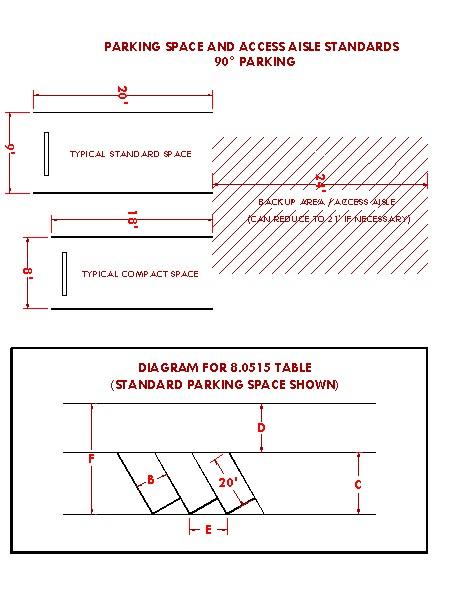
[Section 8.0515 amended by Ord. #2016-17 passed January 31, 2017]
[Section 8.0515 amended by Ord. #2023-07 passed December 19, 2023]
LANDSCAPING REQUIREMENTS
8.0520Landscape Plan Standards.
A. Applicability. A landscape plan is required for proposal which includes any of the following:
1. New housing.
2. Development subject toRDC Article IV Site andDesign review.
3. Planned Unit Development.
4. New wireless broadcast communication facilities, as described in Section8.0415.
B. Contents. A landscape plan need not be prepared by a certified landscape architect unless deviations from the Landscape Design Standards of Section 8.0530 are proposed. In all cases, a landscape plan must include the following to be considered complete:
1. Existing landscaping. The existing landscaping diagram shall depict the location of existing natural features and vegetation on the subject property and adjacent right-of-way areas. Any tree with a diameter of 10 inches as measured at 3 feet above natural grade or greater shall be clearly labeled as a significant tree; smaller trees need not be depicted. Any tree that is shown on the plan shall be identified as coniferous or deciduous and whether the tree(s) is proposed to be retained or removedas part of the development.
2. Proposed landscaping. The proposed landscaping diagram shall depict the location of the vegetation, soil preparations, and irrigation for the subject property and adjacent right-of-way areas and shall be shown in relation to proposed in relation to any provided improvements, including building footprints, frontage improvements, and utility infrastructure. Additionally, the landscape plan must identify the total required landscaping area, as required by RDC Section 8.0530(B), in square feet.
a. Vegetation. The species, native or non-native status, and corresponding water use category (very-low, low, moderate, high, other) as identified in the Oregon State University Extension Office Water-Wise Gardening in Central Oregon Guide, revised June 2020, shall be depicted. The installation size, if applicable, of all vegetation shall be identified. For any tree proposed to be retained, a Tree Protection Zone (TPZ) complying with the Public Works Standards and Specifications shall also be depicted. Allrequired replacement trees shall be clearly labeled.
b. Soil preparation. The type of amendments or treatments to the soil shall be depicted.
c. Irrigation. The method of irrigation proposed for use, including all points of connection and the system components (meters, valves, backflow, quick couplers, blow out ports, main and lateral lines, sprinkler layout, etc.) shall be depicted.
[Section 8.0520 added by Ord. #2023-07 passedDecember 19, 2023]
8.0530Landscape Design Standards.
A. Applicability. Except where conflicting with the City of Remond Public Works Standards and Specifications, these landscaping design standards apply to any proposal which includes any ofthe following:
1. New housing.
2. Development subject toRDC Article IV Site andDesign review.
3. Planned Unit Development.
4. New wireless broadcast communication facilities, as described in Section8.0415.
B. Minimum Landscaping. In all zones, the entirety of the unsurfaced yard area between the main building and any public or private street frontage shall be landscaped. Industrial and public zoned properties shall also be required to provide a 10’ landscape buffer wherever such property directly abuts a residential zoned property, inclusive of structures. Additionally, any hillsides, berms, or other areas with a slope greater than 10% that are disturbed during development shall be revegetated to prevent erosion and dust.
C. Water Features. Required landscaping areas shall not include water features such as fountains, waterfalls, pools, ponds, or year-round standing water collection sites. Canals, approved water drainage facilities, or naturally occurring water features are exempt.
D. Irrigation Systems. Irrigation shall be provided to allow for healthy plant growth. All irrigation shall be subject to the following:
1. Water used for irrigation shall not be permitted to water or run-off onto hard surfaces, such as paved driveways, sidewalks, streets, and other non-vegetated areas. Except for the irrigation water needed to maintain vegetation within an abutting right-of-way, water shall not be allowed to leave the subject property.
2. Trees shall only be irrigated with point-source irrigation such as drip irrigation, bubblers, andtree watering bags.
3. Automatic irrigation systems shall not be allowed without soil-moisture or weather-based irrigation controllers with accompanying sensors and other supporting devices installed to enable smart features.
E. Soil. Soils shall be amended to allow for healthy plant growth and water absorption. Prior to planting, soils shall be made friable by incorporating an organic soil amendment into, at minimum, the top two inches of soil. Additionally, mulch shall be applied to nonvegetated or uncovered areas at a depth of two inches. Both organic and inorganic mulches are allowed, however inorganic mulches are subject to additional standards described in this section. An applicant may submit documentation from a certified landscape architect or soils scientist demonstrating that a different soil treatment that does not comply with this standard is necessary.
F. Landscape Features. Required landscaping areas shall feature trees, shrubs, and live ground covers in combination, and shall not contain invasive species, exposed dirt, or dead vegetation. Non-structural hardscaping, such as boulders, pavers, walkways, courtyards, artificial turf, inorganic mulches and similar are acceptable as a landscaping feature but must not occupy more than 25% of required landscaped areas. Wherever inorganic mulches, including all types of rock groundcovers or mulches, are used, they shall not be used in sections exceeding twenty square feet in size, nor shall any section be closer than ten feet to any other section on the property.
Excluding permissible irrigated turf areas, required landscaped areas must be landscaped only with species which are identified as low or very low water use in the Oregon State University Extension Office Water-Wise Gardening in Central Oregon Guide, revised June 2020. Plant species that do not require irrigation once established are preferred over species that require continued irrigation. Approved water drainage facilities may featuremoderate water-use plant species.
G. Irrigated Turf. This standard applies to all irrigated turf except when used in approved active-style park areas or for recreational purposes within designated common areas. For non-residential zoned properties, not more than 20% of the required landscaped
area may be landscaped with irrigated turf. For residential zoned properties, not more than 25% of the required landscaped area may be landscaped with irrigated turf. Additionally, irrigated turf areas are also subject to the following in all zones:
1. The minimum dimension of any irrigated turf area shall not be less than ten feet.
2. Irrigated turf shall not beplanted in areas with a slope greater than 10%.
3. When planting irrigated turf areas, seed mixes used shall not contain more than 25% cool season grass species.
H. Trees. All trees shall have a 1.5’ trunk diameter as measured at 3’ above natural grade at the time of planting. Existing trees with a 10” trunk diameter as measured at 3’ above natural grade or greater are considered to be significant and shall be preserved to the greatest extent possible. Significant trees that are able to be preserved shall be provided with a Tree Protection Zone (TPZ) in compliance with the Public Works Standards and Specifications to protect the tree during development of the subject property.
1. Where preservation is not feasible, significant trees shall be replaced at a ‘oneto-one’ ratio, inclusive of new street trees adjacent to the subject property.
2. Street trees shall comply with RDC Section 8.0540 Street Tree Standards.
I. Installation and Maintenance. All landscaping installation, including street trees, shall be completed prior to issuance of a Certificate of Occupancy. All landscaping shall be continuously maintained and replaced when necessary to ensure continued compliance with an approved landscape plan. Additionally, street trees shall be maintained in accordance with the standards listed in Section 3.600 of the Redmond City Code. For landscaping valued in excess of $5,000, a maintenance bond may be required.
J. Deviation and Payment In Lieu. The Community Development Director or designee retains the discretion to:
1. Approve a deviation from any of the standards of this section without requiring a variance when the deviation is proposed by a certified landscape architect.
2. Establish a fee in lieu per tree where the property is not physically feasible to replace tree(s). The feewill be specified in the City Fee Schedule.
[Section 8.0530 added by Ord. #2023-07 passedDecember 19, 2023]
8.0540Street Tree Standards. Street trees are required wherever the subject property abuts public or private streets and shall be subject to the following:
A. Species of Street Trees. Street trees shall be selected from the most recent City of Redmond Approved Street Trees list.
B. Amount of Required Street Trees. The amount of street trees required to be installed shall be based on the length of the development frontage, less the clearance areas, divided by the required spacing distance. The required spacing distance is based on the species of tree and described in the City of Redmond Approved Street Trees list. Clearance areas are described in subsection Cbelow.
Number of Trees Required = [(Length of Development Frontage) – (Clearance Areas)] / (Required Spacing Distance)
C. Placement of Street Trees. Trees shall be centered in the landscape strip or shoulder, where applicable, at the required spacing distance. The required spacing distance of street trees is based on the species of tree and described in the City of Redmond Approved Street Trees list; spacing shall be measured from the center of the trunk of the tree. The spacing distance of street trees shall be adjusted based on thefollowing:
1. Clearance Areas, wherein no tree shall be planted. Clearanceareas include:
a. Clear vision areas;
b. Sight distance areas;
c. Stopping distance areas;
d. Medians less than four feet wide;
e. Utility easements;
f. City easements, unlesspermitted by City Engineer.
2. Buffers, which provide space between a tree and boundaries, infrastructure, improvements, or other physical barrier, shall be provided as described in the table below.
Physical Barrier Required Buffer
Stop Signs
Other Traffic Signs
Streetlights
Non-Streetlight Utility Poles
Retaining Walls
Fire Hydrants 10 feet
Water or Sewer Meter/Service, including vaults, utility boxes, sampling manholes 5 feet
Catch Basins, Sedimentation Manhole, Drywell 10 feet
Intersections 35 feet
Alleys 10 feet
Driveways 5 feet
Sidewalks, Curbs 2 feet, unless centered in landscape strip
Property Lines 2 feet
Other
Subject to City Engineer review
3. Existing street trees may be factored into spacing distance and placement of street trees.
D. The Community Development Director or designee may approve alternate street tree species selections and placements. Additionally, in the event that the required amount of street trees cannot be entirely accommodated within the public or private street frontage based on the above standards and adjustments, street trees may be permitted to be located on private property within five feet of the right-of-way, utility easement boundary, or property line.
[Section 8.0540 added by Ord. #2023-07 passedDecember 19, 2023]
EXCEPTIONS
8.0550Exception to Lot Size Requirements. If a lot or the aggregate of contiguous lots or parcels platted prior to the effective date of these standards has an area or dimension which does not meet the requirements of these standards, the lot or aggregate holdings may be put to use permitted subject to the other requirements of the zone in which the property is located. Lots that are pre-existing in residential zones that are below the minimum size for a single-family dwelling shall be limited to one single family dwelling per lot.
[Section 8.0550 amended by Ord. #2020-15 passed November 10, 2020]
8.0555Exception to Yard Requirements. The Hearings Body may increase the yard requirement when a yard abuts a street which the City has designated for future widening. A lesser front yard may be allowed when structures on abutting lots do not meet the front yard requirements of the zone in which it is located.
[Section 8.0555 amended by Ord. #2020-15 passed November 10, 2020]
8.0557Exception to Building Setback Requirements. Any parcel of land or portion thereof which is taken by or is dedicated to a public or semi-public entity for a road, canal, railroad, utility, or other public use shall be exempt from the building setback requirements set forth by the Redmond Development Code standards when such dedication of land reduces a setback for an existing building or structure. Such setback shall be treated as a non-conforming setback by the City and shall be subject to those Code regulations and provisions that regulate non-conforming uses.
8.0560Exception to Yard and Height Requirements for Detached Non-Habitable Accessory Buildings.
[Section 8.0560 deleted by Ord. #2016-17 passed January 31, 2017]
8.0565Exception to Building Height Limitations. Except for the FAA aviation requirements set forth in Federal Law, the following types of structures or structural parts are not subject to the building height limitations prescribed in Sections 8.0100-8.0295: architectural elements used for roofs, art, chimneys, church spires, clock towers, belfries, domes, monuments, fire and hose towers, observation towers, flag poles, air traffic navigational equipment, cooling towers, elevator shafts and other similar projections. Prior to construction of these structures or structural parts, a site plan shall be required in accordance with Site & Design Review Standards unless exempted by Code, or at the discretion of the Community Development Director, or Hearings Body.
[Section 8.0565 amended by Ord. #2020-15 passed November 10, 2020]
[Section 8.0565 amended by Ord. #2022-04 passed June 28, 2022]
8.0570Divided Legal Lots and Parcels. A single legal lot or parcel of record may be considered as a divided lot or parcel for the purposes of these standards if it is divided by a major irrigation canal, railroad, or major topographic feature, or by a city, county, state, or federal road. No right-of-way width less than 50 feet shall constitute an effective division. A newly divided lot or parcel that is sought due to the constraints established herein must be created through the partition or subdivision process. If the
land division is the result of a city condemnation, then no planning fee shall be assessed.
8.0575Special
ExceptionstoLot Size Requirements.
1. Any parcel of land or portion thereof, which is required to dedicate a public or semipublic road, canal, railroad, utility, or other public use, shall be exempt from the minimum lot size requirements set forth by these standards, unless part of a proposed subdivision.
2. For partitions involving parcels located in residential areas platted before the effective date of the current minimum lot size standards and abutting lots or parcels of substandard size under the current minimum lot size standards, an exception to the minimum lot size in the zone may be allowed if the following criteria are met:
A. The minimum lot size for a parcel created pursuant to this exception shall be equal to or greater than the smallest lot area of the lots or parcels abutting the parent parcel.
B. The exception provides for adequate provision of light, air, and privacy to abutting properties. This section does not exempt solar setbacks from being applied for any lot created under these provisions (whereapplicable).
C. The exception provides for the preservation of natural features, where appropriate.
D. The exception will have minimal adverse impact on the livability, value or development of abutting properties and the surrounding area.
[Section 8.0575 amended by Ord. #2022-04 passed June 28, 2022]
CONDITIONAL USES
8.0600Authorization to Grant or Deny Conditional Uses. Uses designated herein as conditional uses may be permitted upon authorization by the Hearings Body in accordance with the standards and procedures established in this article. Before approving an application for a conditional use, the Hearings Body shall find the following criteria are either met, can be met by observanceof conditions, or are not applicable:
1. The proposed use will be consistent with the Comprehensive Plan, the zoning ordinances and other applicable ordinances and standards of the City.
2. The location, size, design, and operating characteristics of the proposed use will have minimal adverse impact on the livability, value, or approximate development of abutting properties and the surrounding area.
3. The proposed use will not exceed operational capacity of City infrastructure including sewage system, water system or the transportation system.
4. That the proposed use will not conflict with, diminish, or substantially adversely affect the character and natureof the established neighborhood in which it is located.
[Section 8.0600 amended by Ord. #2020-15 passed November 10, 2020]
8.0602Neighborhood Meeting. Proof a neighborhood meeting was conducted for residential or mixed use development proposals that generate 200 or more daily trip ends, or 20 or more p.m. peak hour trip ends, where a Transportation Impact Analysis (TIA) is required, See Section 8.0385 for meeting requirements.
[Section 8.0602 added by Ord. #2022-09 passedDecember 13, 2022]
8.0605General Conditions. In addition to the ordinances set forth in a specific zone, this article, and other applicable standards and criteria used in addressing a new conditional use or the alteration of an existing conditional use, the Hearings Body may impose conditions which it finds necessary to avoid an unacceptable impact and to otherwise protect the best interests of the surrounding area or the City. These conditions may include the following:
1. Limiting the way the use is conducted including restricting the time an activity may take place and establish conditions or restraints that will minimize such environmental effects as noise, vibration, air pollution, glare, and odor. The City may require additional proof from the applicant that quantifies compliance with this requirement at the time of application submittal.
2. Establishing an open space or recreation area.
3. Limiting the height, size, or location of a building or other structure(s).
4. Designating the size, number, location, and nature of vehicle access points.
5. Increasing the amount of street dedication, roadway width or improvements within the street right-of-way, including (but not limited to) lighting and landscaping improvements. Any oversizing of public infrastructure that is required by the City that exceeds minimum City standards may be a candidate for SDC credits at the discretion of the City Engineer or designate.
6. Designating the size, location, screening, landscaping, drainage, surfacing, or other improvement within a parking area or loading zone.
7. Limiting or otherwise designating the number, size, location, height, and lighting of signs.
8. Limiting the location and intensity of outdoor lighting and requiring it’s shielding from any adjacent properties, or public or private streets and roads.
9. Requiring diking, screening and/or landscaping of a facility to protect adjacent or nearby property and designating standards for its installation and maintenance.
10. Designating the size, height, location, and materials for a fence.
11. Protecting and preserving existing trees, vegetation, or other significant natural resources.
[Section 8.0605 amended by Ord. #2020-15 passed November 10, 2020]
8.0610Permit and Improvements Assurance. The Hearings Body may require an applicant to furnish the City with a performance bond, cash deposit, or equivalent deemed necessary to guarantee development in accordance with these standards and the conditions attached in granting a conditional use permit. Such assurance shall be accepted at the discretion of the City Finance Director or designate.
8.0615Standards Governing Conditional Uses. A conditional use shall comply with the standards and criteria of the zone in which it is located and with the standards and criteriaset forth in this section and in sections 8.0600 and 8.0605.
1. Airports, aircraft landing fields, aircraft charter, rental, service, and maintenance facilities not located in an Airport Zone / Airport Compatibility Zone: The Hearings Body shall find that the locations and site design of the proposed facility will not be hazardous to the safety and general welfare of surrounding properties, nor that the location will unnecessarily restrict existing and future development of surrounding lands as designated by the ComprehensivePlan.
2. Automobile recycling, wrecking yard, or junk yard: In considering a conditional use application for an automobile recycling facility, wrecking yard or junk yard, the Hearings Body shall require that the facility or yard be enclosed and screened from public view by a sight obscuring and well maintained fence not less than six feet in height. All personal property shall remain inside the fence. If applicable, the Hearings Body shall be assured that the proposed use is in conformance with applicable Stateregulations.
3. Bed and Breakfasts: A bed and breakfast shall comply withthe following provisions:
A. All new construction or conversions of existing structures to a Bed and Breakfast require Site and Design Review.
B. All such uses are in conformance with applicable, City Sign Standards.
C. All such uses shall have a maximum of 5 guest suites.
D. All such uses shall provide one parking space per guest suite in addition to the residential use requirement of two spaces.
E. All such uses provide parking areas to be screened as per design review standards.
4. Cemeteries: The Hearings Body shall require evidence and shall find that the terrain and soil types of a proposed location are suitable for interment, and that the nature of the subsoil and drainage will not have a detrimental effect of ground water sources or domestic water supplies in the area of the proposed use.
5. Church, hospital, and other public / semi-public uses:
A. Such uses may be authorized as a conditional use only after consideration of the following factors:
1. Adequacy of access to and from principal streets together with the probable effect of the traffic volumes on abutting and nearby streets, and mitigation of associated impacts.
a. Such uses or related buildings shall be at least 30 feet from a side or rear lot line when abutting a residential use.
b. Adequate off-street parking.
c. Adequate building and site design provisions to minimize noise and glarefrom the building and site.
B. Such uses may be built to exceed the height limitations of the zone in which it is located to a maximum of 50 feet if the total floor area of the building does not exceed the area of the site and if the yard dimensions in each case are equal to at least two-thirds of the height of the principal structure.
6. Commercial use or accessory use not wholly enclosed within a building. In any zone permitting a commercial use or accessory use not wholly enclosed within a building the use may be permitted as a conditional use subject to the following standards:
A. A sight obscuring fence or evergreen hedge may be required by the Hearings Body when in its judgment, such a fence or hedge combination thereof is necessary to preserve the values of nearby properties or to protect the aesthetic character of the neighborhood or vicinity.
B. In addition to the requirements of the applicable zone, the Hearings Body may further regulate the placement and design of signs and lights in order to preserve the values of nearby properties; to protect them from glare, noise, or other distractions; or to protect the aesthetics character of the neighborhood or vicinity.
C. In order to avoid unnecessary traffic congestion and hazards, the Hearings Body may limit access to the property.
7. A retail establishment, office, service commercial establishment, financial institution, or personal or business service establishment on a lot abutting or across the street from a lot in a residential zone. In any zone permitting a commercial use such as a retail establishment, office, service commercial establishment, financial institution, or personal or business service establishment on a lot abutting or across the street from a lot in a residential zone, the use may be permitted as a conditional use subject to the following standards:
A. A sight obscuring fence or evergreen hedge may be required by the Hearings Body when in its judgment, such a fence or hedge combination thereof is necessary to preserve the values of nearby properties or to protect the aesthetic character of the neighborhood or vicinity.
B. In addition to the requirements of the applicable zone, the Hearings Body may further regulate the placement and design of signs and lights in order to preserve the values of nearby properties; to protect them from glare, noise, or other distractions; or to protect the aesthetics character of the neighborhood or vicinity.
C. In order to avoid unnecessary traffic congestion and hazards, the Hearings Body may limit access to the property.
8. Commercial amusement establishment: A commercial amusement establishment may be authorized after consideration of the following factors:
A. Adequacy of access from principal streets together with the probable effect on traffic volumes of abutting and nearby streets.
B. Adequacy of off-street parking.
C. Adequacy of building and site design provisions to maintain a reasonable minimum of noise and glare from the building and site.
D. Hours of operation which do not conflict with adjacent residential uses where applicable.
9. Dog pounds and kennels: The Hearings Body may authorize a dog pound or kennel as a conditional use if that building and site design provisions are adequate to minimize noise and odor. When necessary to protect surrounding properties, the Hearings Body may require a sight obscuring fence or hedge, and may restrict vehicular access and loading facilities, especially those required by trucks transporting large animals.
10. Hotels in the M-1 Light Industrial Zone: Hotels may be permitted in the Light Industrial Zone only if the Hotel is:
A. A minimum of 50 rooms, and
B. Adjacent to and accessed from a designated arterial street
11. Mining, quarrying, or other extraction activity:
A. Plans and specifications submitted to the Hearings Body for approval must contain sufficient information to allow the Hearings Body to consider and set standards pertaining to the following:
1. The most appropriate use of the land;
2. Setback from the property line;
3. The protection of pedestrians and vehicles through the use of fencing and screening;
4. The protection of fish and wildlife habitat and ecological systems through control of potential air and water pollutants;
5. The prevention of the collection and the stagnation of water at all stages of the operation;
6. The rehabilitation of the land upon termination of the operation.
B. Surface mining equipment and necessary access road shall be constructed, maintained, and operated in such manner as toeliminate, as far as is practicable, noise, vibration, or dust which may be injurious or annoying to persons or other uses in the vicinity.
C. The comments and recommendations of all appropriate natural resources agencies of the state and federal government shall be sought.
D. A rock crusher, washer, or sorter shall not be permanently located closer than 500 feet from aresidential or commercial zone.
12. Manufactured Home Park. A manufactured home park shall be built to site standards in effect at the time of construction and shall comply with the following additional provisions:
A. Evidence shall be provided that the park will be connected to City sewer and water services.
B. The space provided for each manufactured home shall be provided with city water and electrical and sewerage connections.
C. The number of spaces for manufactured homes shall not exceed nine (9) for each acre of the total area in the manufactured home park.
D. A manufactured home shall occupy not more than 40 percent the contiguous space provided for the exclusive use of the occupants of the manufactured homes and exclusive of space provided for the common use of tenants, such as roadway, general use structures, parking spaces, walkways, and areas for recreation and landscaping.
E. No manufactured home in the park shall be located closer than 15 feet from another manufactured home or from a general use building in the park. No manufactured home accessory building shall be closer than 10 feet from a manufactured home space or other building or structure. No manufactured home or other building or structure shall be within 25 feet of a public street property boundary or 10 feet of another property boundary.
F. A manufactured home permitted in the park shall meet the following standards as determined by an inspection by the Building Official:
1. It shall have a State insignia indicating compliance with Oregon State Manufactured Home Construction Standards in effect at the time of manufacture and including compliance for reconstruction or equipment installation made after manufacture.
2. Notwithstanding deterioration which may have occurred due to misuse, neglect, accident, or other cause, the manufactured home shall meet the State standards for manufactured home construction evidenced by the insigne.
3. It shall contain not less than 225 square feet of space as determined by measurement of the unitexclusive of any trailer hitch device.
4. It shall contain a water closet, lavatory, shower or tub, and a sink in a kitchen or other food preparation space.
5. A manufactured home permitted in the park shall be provided with a continuous skirting.
6. There shall be no outdoor storage of furniture, tools, equipment, building materials or supplies belonging to the occupants or management of the park.
7. If the park provides space for 50 or more manufactured home units, each vehicular way in the park shall be named and marked with signs which are similar in appearance to those used to identify public streets. A map of the named vehicular ways shall be provided to the fire department.
8. If a manufactured home space or permanent structure In a park is more than 500 feet from a public fire hydrant, the park shall have water supply mains designed to serve fire hydrants and hydrants shall be provided within 500 feet of such space or structure. Each hydrant within the park shall be located on a vehicular way and shall conform in design and capacity tothe public hydrants in the City.
9. Open Space. A minimum of at least 2,500 square feet plus 150 square feet per manufactured home space shall be provided recreation area. Recreation areas shall be improved with surfacing, facilities suitable for recreational use, or landscaping. No recreation facility created within a manufactured home park wholly to satisfy the requirements of this section shall be open to, or offered in itself, to the general public. The Community Development Director, or designee, may require the recreation area to be centrally located within the park and physically separated from streets or parking by afence that complies with fence regulations.
10. Parking Space Requirement. Two parking spaces shall be provided for each manufactured home space on the site. In addition, guest parking spaces shall also be provided in every manufactured home park within 200 feet of the manufactured home spaces served and at a ratio of one parking space for each two manufactured home spaces. Parking spaces shall have durable and dustless surfaces adequately maintained for allweather use and shall be properly drained.
11. All manufactured home parks over 10 acres in size shall be located to have access on a street designated as a collector street unless otherwise approved by aHearings Body.
12. All manufactured home parks containing a total site area of 20 acres or more shall provide a secondary access to the mobile home park. Such
secondary access shall enter the public street system at least 150 feet from the primary access.
13. Lighting shall be installed along the access ways of the manufactured home park and the recreation area with lights of 100 watts or better or not over 100 feet apart. Wires for service to light poles and trailer spaces shall be underground.
14. Roadways within the park shall be paved and shall be not less than 30 feet in width if parking is permitted on the margin of the roadway, or less than 24 feet in width if parking is not permitted on the edge of the roadway and an adequate designated area is provided and improved for guest parking and tenant recreational vehicles (such area shall be designed and improved to provide not less than one parking space per each twounit spaces in the park).
15. No manufactured home park shall be created on a site of less than three acres.
16. Sidewalks or other approved surfaced pedestrian walkways shall be provided.
17. Public Park. The developer shall be required to either dedicate land for a public park or pay a sum into a park fund in accordance with the provisions set forth in Section 8.0355 of these standards.
13. Multi-Family Complex: A Multi-family complex shall comply with the following provisions:
A. If such complex or any unit thereof is more than 500 feet from a public fire hydrant or as otherwise required by the uniform fire code, then a new hydrant or hydrants shall be provided at appropriate locations as determined by the Fire Marshal. Such hydrants shall be located on a vehicular way and shall conform in design and capacity to the public hydrants in theCity.
B. All such complexes with more than 20 dwelling units shall be located to have access on a street designated as a collector unless otherwise approved by the Hearings Body.
C. Sidewalks or other approved surfaced pedestrian walkways shall be provided.
14. Recreational Vehicle Park: A recreational vehicle park shall be built to State standards in effect at the time of construction and shall comply with the following provisions:
A. Use Standards.
1. No recreational vehicle park or overnight use area shall be permitted with access further than 1,000 feet from a designated arterial or collector street or private street of equal paved width. Further, such access roads shall be designed and constructed at the maximum design standards for right-of-way and/or pavement width (60 feet/36 feet). A lesser standard of not less than 30 feet may be approved by the hearings body if no street parking is allowed, sufficient off-street parking is provided and only if the proposed park plan is accompanied by an approved maintenance and enforcementmanagement agreement.
2. The design of recreational vehicle parks shall be subject to site plan review and approval and haveminimal adverse impacts.
3. Management headquarters, recreational facilities, toilets, dumping stations, showers, coin-operated laundry facilities, and other uses and structures customarily incidental to operation of a recreational vehicle park and campground are permitted as accessory uses to the park.
B. Design Standards.
1. The maximum density of an RV park shallbe 20units per acre.
2. The space provided for each recreational vehicle site shall be not less than 1,200 square feet, exclusive of any space used for common areas, such as roadways, general use structures, walkways, common parking areas, and landscaped areas.
3. Roadways other than those described above shall be not less than 30 feet in width if parking is permitted on the margin of the roadway, or less than 24 feet in width if parking is not permitted on the edge of the roadway, shall be paved with asphalt, concrete, or similar impervious surface, and designed to permit easy access to each recreational vehicle space. When a service drive provides only secondary access to all abutting recreational sites and those sites are all served by a roadway meeting the above standards, the secondary drive may be reduced to 14 feet if one-way and posted for no parking.
4. Entrance driveways shall be located not closer than 150 feet from the intersection of public streets.
5. A space provided for a recreational vehicle shall be covered with dustfree crushed gravel, or paved with asphalt, concrete or similar materials, and be designed to provide runoff of surface water. The portion of the space not occupied by a recreational vehicle and not intended as an access way to the recreational vehicle or part of an outdoor patio need not be paved or covered with gravel, provided the area is landscaped or otherwise treated to prevent dust or mud.
6. A recreational vehicle space shall be provided with piped, potable water and sewage disposal service. A recreational vehicle staying in the park shall have available water and sewage service provided by the park if the vehicle has equipment needing such service.
7. A recreational vehicle space shall be provided with electric service.
8. Trash receptacles for the disposal of solid waste material shall be provided in convenient locations for the use of guests of the park and shall be of such capacity and number so that there is no accumulation of uncovered trash at any time. Trash shall be removed from the property on a scheduled basis to prevent health hazardor nuisance.
9. No recreational vehicle or any other camping unit shall be used as a permanent residence, dwelling, or business for indefinite periods of time. Occupancy or placement extending beyond six months in any 12-period shall be presumed to be permanent occupancy. Any action toward removal of wheels of a recreational vehicle except for temporary purposes of repair is prohibited. Camping units other than recreational vehicles shallbe limited to 30-days in any 60-day period.
10. The total number of parking spaces in the park, exclusive of parking provided for the exclusive use of the manager or employees of the park shall be equal to one space per recreational vehicle space. Parking spaces shall be covered with crushed gravel, or paved with asphalt, concrete, or similar material, providing a dust- free surface.
11. The recreational vehicle park shall provide toilets, lavatories and showers for each sex as required by the State Building Agency Administrative Rules, Chapter 918. Such facilities shall be lighted at all times of night and day, shall be ventilated, and shall be provided with adequate floor drains to permit easy cleaning.
12. Recreational vehicles or other camping units shall be separated from each other and from other structures by at least 8 feet. Accessory
structures such as attached awnings or individual storage facilities shall, for purposes of this separation requirement, be considered to be part of the recreational vehicle.
13. The land which is used for park purposes shall be screened from sight, except at entry and exit places. The screening provided shall complement the landscape and ensure compatibility with surrounding properties.
15. Radio, television tower, utility station, or substation: Transmitting and receiving towers and antennas are allowed as a conditional use and subject to the requirements set forth in Sections 8.0400-8.0490 of these standards.
16. Child Care Facilities: Child Care Facilities shall provide and maintain at least 75 square feet of outdoor play area per child. A sight obscuring fence at least four feet but not more than six feet high shall separate the play area from the abutting lots.
17. Mini-Storage Developments:
A. The site shall contain aminimum of 3 acres.
B. The site shall have access only on a minor arterial, major collector, or minor collector.
C. The maximum lot coverage shall not exceed sixty percent of the total lot area.
D. No more than one (1) dwelling may be located on the site and the purpose of the dwelling shall be for the operation, maintenance, and security of the mini-storage development.
E. All outdoor storage of recreational vehicles or boats shall be screened from view in a manner that will complement the landscape and assure compatibility with adjacent uses.
F. All roadways within the mini-storage development shall be a minimum of twenty (20')feet in width and shall be paved.
18. Development in theOSPR zone.
A. An application for a conditional use other than for a public facility shall be denied if the proposed use is not related to or complimentary, or compatible with the recreational, historical, or scenic resources of the area.
B. The Hearings Body may limit changes in the natural grade of land or the alteration, removal, or destruction of natural vegetation in order to prevent or minimize erosion, pollution, or degradation of the natural attractiveness of the area.
C. The Hearings Body may require establishment and maintenance of fire breaks, the use of fire-resistant materials in construction and landscaping; or may attach other similar conditions or limitations that will serve to reduce fire hazards or prevent the spread of fireto surrounding areas.
D. An application for a conditional use in an OSPR Zone shall be denied if the height of any structures or buildings unduly affects the natural and scenic features of the area.
E. Development of public or privaterecreational centers or community centers must:
1. Be in or within one hundred feet of an enhancement area as defined on the map.
2. Provide access to a specific parcel from existing routes accessing the canyon or routes designated in the plan maps as set forth within the adopted Canyon Master Plan and Comprehensive Plan for the City of Redmond.
3. Be reasonably accessible for people of all ages and social and economic groups and for all geographic areas of the community.
4. Be coordinated with adjacent open space areas and other land uses so they enhance one another and together contribute to a satisfying park environment.
5. Provide for the preservation or enhancement of natural features, resources, and amenities, including views and vistas, canyon walls, nativejuniper stands and exposed rock outcroppings.
F. Except for the development of public facilities and services, it shall be unlawful to fill, discard or store solid wastes of any kind, including but not limited to excavation, tailings, rubbish, auto bodies, junk, and other similar materials, to store any materials which are unsightly within the canyon area soil, trees, shrubbery, or other natural vegetation.
19. Development in the R-3A. In addition to other conditional use standards and criteria applicable in the R3 zone, an application for conditional use in the R-3A zone shall be subject to the following criteria:
A. The hearings body may limit the hours of operation (open to the public) of a commercial business allowed as a conditional use in the R3A zone so that the use is compatible with the surrounding residential neighborhood. For restaurant or theater uses, the hearings body may limit hours of operation to no later than 9:00 p.m. on weekdays and 10:00 p.m. on weekends. For other commercial uses, the hearings body may limit hours to be after 8:00 a.m. and no later than 6:00 p.m.
B. The applicant shall provide a plan to ensure that there is adequate off-street parking for the proposeduse.
C. Signage in the R3A zone shall be limited to either one ground mounted sign no larger than five x three (5 x 3) square feet, or in the alternative, a non-illuminated wall size of similar size.
D. Retail uses shall be limited to those types of businesses which provide low traffic impacts on the surrounding areas such as computer stores, clothing stores.
E. Any restaurant allowed shall be a full service restaurant. No fast-food restaurants or drive-in/drive-through restaurant will be allowed in the R3A zone.
[Section 8.0615 amended by Ord. #2015-04 passed May 19, 2015]
[Section 8.0615 amended by Ord. #2016-17 passed January 31, 2017]
[Section 8.0615 amended by Ord. #2020-15 passed November 10, 2020]
[Section 8.0615 amended by Ord. #2022-04 passed June 28, 2022]
[Section 8.0615 amended by Ord. #2022-09 passed December 13, 2022]
[Section 8.0615 amended by Ord. #2023-07 passed December 19, 2023]
8.0616Conflicts. Where there is a conflict between any other standards for uses in the R3 zone and these criteria, the criteria set forth in8.0615 shall control.
8.0625Public Hearing on a Conditional Use. A public hearing may be required at the discretion of the Community Development Director, or designee, for any conditionally permitted use. If required, the hearing shall follow the procedure described in Land Use Administrative actions allowed under ArticleII.
[Section 8.0625 amended by Ord. #2022-04 passed June 28, 2022]
CHAPTER 8 DEVELOPMENT REGULATIONS
8.0630Termination of Use. A conditional use permit approval may have a termination date that indicates when the use is no longer permitted through the conditional use approval. If applied, then such dates shall be specified within the conditions of approval for the Conditionally PermittedUse.
8.0635Time Limit on a Permit for a Conditional Use. Authorization of a conditional use shall be void after two years or such lesser time as the authorization may specify unless substantial construction has taken place. However, the Community Development Director, or Hearings Body, may allow extensions as provided in Section 8.1610. (3/99)
8.0640Occupancy Permit. The Commission may require an "Occupancy Permit" for any conditional use approved pursuant to the provisions of these standards. The Hearings Body shall consider such a requirement for any use authorized by a conditional use permit for which on-site improvements, or other such conditions were established by the Hearings Body upon approval of such use. The requirement of an Occupancy Permit shall be for the intent of insuring permit compliance and said permit shall not be issued except as set forth by the Hearings Body. The authority to issue an Occupancy Permit upon compliance with the requirements and conditions of a conditional use permit may be delegated by the Hearings Body to the Community Development Director.
8.0645Performance Bond. The Hearings Body may require the applicant to furnish the city with a performance bond or other adequate form of assurance to guarantee development in accordance with the standards and conditions attached in granting a conditional use permit.
NON-CONFORMING USES
8.0660Non-Conforming Uses - Continuation of a Non-Conforming Use or Structure. Subject to the provisions of this article, a non-conforming use or structure existing prior to the effective date of these standards may be continued and maintained in reasonable repair. A structure conforming with respect to use but non-conforming regarding height, setback, or lot coverage may be altered or extended if the alteration or extension does not further deviate from these standards and does not adversely affect adjacent property or public right of ways.
8.0665Discontinuance ofa Non-Conforming Use.
1. If a non-conforming use involving a structure is discontinued for a period of one year, further use of the property shall conform to these standards; except that previous residential use may be allowed as a conditional use pursuant to Sections 8.0600-8.0645 provided that the conditional use application is filed with the City within one (1) year of the cessation of the non-conforming use.
2. If a non-conforming use not involving a structure is discontinued for a period of one year and if a conditional use application to allow a residential use is not filed with the City, further use of the property shall conform to these standards.
8.0670Change of a Non-Conforming Use. If a non-conforming use is replaced by another use, the newuse shall conform to all applicable zoning and development standards.
8.0680Destruction of a Non-Conforming Use. If a non-conforming structure or a structure containing a non-conforming use is destroyed by any cause to an extent exceeding 60 percent of fair market value as indicated by the records of the County Assessor, a future structure or use on the site shall conform to the zoning standards and all applicable provisions of the Redmond Development Code; except that previous residential use may be allowed as a conditional use pursuant to Sections 8.0600-8.0645 provided that the conditional use is allowed in the zone and that the application is filed with the City within one (1) year of the destruction of the existing non-conforming use.
8.0685Alterations and Repairs.
1. Alteration of a non-conforming use shall be permitted to reasonably continue the use. Alteration of any such use may be permitted when necessary to comply with any lawful requirement for alteration in the use.
2. Any application for the alteration of a use under sub-section (1) above, including, but not limited to, an alteration necessary to comply witha lawful requirement, shall be permitted in accordance with these standards and this section. "Alteration" of a non-conforming use may be allowed when the owner / developer demonstrates that:
A. The alteration or change in the use results in less or no greater adverse impact to the neighborhood,
B. A change in the structure or physical improvement results in less or no greater adverse impact tothe neighborhood.
C. There is no adverse impact on any public facility, including right of ways or public easements, located on or adjacent tothe property.
8.0695Non-Conforming Lots of Record. Any lot which is smaller than the minimum area required in any zone may be developed and occupied by an allowed use in that zone provided that:
1. The lot is a legal lot of record which includes, but is not limited to, lots in a duly platted and recorded subdivision on or before the effective date of these standards or parcels created by an approved land partitioning prior to the effective date of the subdivision ordinance.
2. The use conforms to all other requirements of that zone, including setbacks, access, and any applicable site design requirements.
3. If there is an area deficiency, a permitted residential use shall be limited to a single dwelling unit and may include accessory structures and uses, including home occupations and garages.
[Section 8.0695 amended by Ord. #2022-09 passed December 13, 2022]
VARIANCES
8.0700Authorization to Grant or Deny Variances. Except as provided for in Section 8.0710, the Community Development Director, or Hearings Body, may authorize variances from these standards where it can be shown that owing to special and unusual circumstances related to a specific piece of property, the literal interpretation of these standards would cause an undue or unnecessary hardship; except that no variance shall be granted to allow the use of the property for purposes not authorized within the zone, or to alter any procedural requirements of these standards. Variances to residential yard/setback requirements may be allowed as described below and may include conditions to protect the best interest of the surrounding property or neighborhood and to otherwise achieve the purposes of these standards.
[Section 8.0700 amended by Ord. #2016-17 passed January 31, 2017]
[Section 8.0700 amended by Ord. #2020-15 passed November 10, 2020]
8.0705Standards Required to Grant Major Variances. A major variance may be granted pursuant to the provisions of Section 8.0700 if the applicant can establish the following:
1. That special conditions exist which are peculiar to the land, structure or building involved and which are not applicable to other lands, buildings, or structures in thesamezone.
2. That strict interpretation of these standards would deprive the applicant of rights commonly enjoyed by other properties in the same zone under the terms of these standards.
3. That the special conditions and circumstances do not result from the actions of the applicant and such conditions and circumstances do not merely constitute pecuniary hardship or inconvenience.
4. That granting the variance will be in harmony with the objectives of these standards, and not injurious to the neighborhood or otherwise detrimental to the public welfare.
[Section 8.0705 amended by Ord. #2020-15 passed November 10, 2020]
8.0710Standards Required to Grant Minor Variances to On-Site Requirements. A minor variance under this section shall be no greater than 25% of the requirement from which the variance is sought. The Community Development Director, or designee, may consider a variance from these standards relating to on site requirements.
1. In the case of a yard setback variance, the applicant shall show the approval will result in:
A. More efficient use of the site.
B. Preservation of natural features where appropriate.
C. Adequate provisions of light, air, and privacy to adjoining properties.
D. Adequate access.
2. In the case of a variance to the dimensional standards for off-street parking spaces or the minimum required number of off-street parking spaces, the applicant shall show that approval will provide adequate off-street parking in relation to user demand. The following factors may be considered in granting such an exception:
A. Special characteristics of users which indicate low demand for off-street parking (e.g., low income, elderly).
B. Opportunities for joint use of nearby off-street parking facilities.
C. Availability of public transit.
CHAPTER
D. Natural features of the site (topography, vegetation, and drainage) which would be adversely affected by application of required parking standards.
3. For variances to other on site requirements of 25% or less the applicant shall show that approval of the variance will be consistent with the overall objectives of the Comprehensive Plan and zoning standards where applicable, and that the variance will have a minimal adverse impact on the livability, value or development of abutting properties and the surrounding area.
[Section 8.0710 amended by Ord. #2022-04 passed June 28, 2022]
8.0720Application for a Variance. A property owner may initiate a request for a variance by filing an application with the Community Development Department. The application shall be accompanied by a plan, drawn to a suitable scale, showing the condition to be varied and the dimensions and arrangement of the proposed development. The application shall be reviewed in the manner provided for in Article II, or, if in conjunction with site plan review, in the manner provided for in the Site & Design Review Standards.
[Section 8.0720 amended by Ord. #2020-15 passed November 10, 2020]
AMENDMENTS
8.0750Authorization to Initiate Amendments. An amendment to the text of this chapter (Redmond Development Code), to the Comprehensive Plan, or an amendment to the Comprehensive Plan Map may be initiated by City Council, Planning Commission, or Community Development Director. A property owner may initiate a request for a map or text amendment by filing an application with the Community DevelopmentDepartment.
[Section 8.0750 amended by Ord. #2020-15 passed November 10, 2020]
[Section 8.0750 amended by Ord. #2022-04 passed June 28, 2022]
[Section 8.0750 amended by Ord. #2022-09 passed December 13, 2022]
8.0755Zone / Plan Map Amendments.
[Section 8.0755 deleted by Ord. #2020-15 passed November 10, 2020]
8.0760Criteria for Amendments. The burden of proof is upon the applicant. The applicant shall show the proposedchange is:
1. In conformity with all applicable State statutes;
2. In conformity with the State-wide planning goals whenever they are determined to be applicable;
3. In conformity with the Redmond Comprehensive Plan, land use requirements and policies; and
4. That there is a change of circumstances, further studies justifying the amendment or mistake in the original zoning.
[Section 8.0760 amended by Ord. #2020-15 passed November 10, 2020]
8.0765Tentative Approval. Based on the facts presented at the hearing and the recommendation of the Planning Commission, if the Hearings Body determines that the applicant has met all applicable criteria for the proposed change, the Hearings Body shall give tentative approval of the proposed change. Such approval shall include any conditions, stipulations, or limitations which the Hearings Body determines to be necessary to meet the criteria. An appeal of the Hearings Body’s decision shall be processed and decided in the manner provided for in Article II of these standards. Upon completion of hearings process, the council shall, by order, effect the zone reclassification of the property. Provided, however, if the applicant fails to abide by the conditions attached to the rezoning the Council may, later, rezone the affected property to its original zoning by order.
[Section 8.0765 amended by Ord. #2020-15 passed November 10, 2020]
8.0770Public Hearing on Amendments. If a map change is initiated by the Planning Commission or City Council, or if an amendment to the text of these standards is to be considered, the City Council shall hold a public hearing on the proposed change. Notice of the hearing shall be published in a newspaper of general circulation in the City the week prior to the hearing. Before establishing a map change, the Council shall make findings that the proposed change meets the criteria set forth in Section 8.0760. Any change affected under this section shallbe by ordinance.
CHAPTER 8 DEVELOPMENT REGULATIONS
8.0775Limitations on Re-Applications.
[Section 8.0775 deleted by Ord. #2020-15 passed November 10, 2020]
GENERAL PROVISIONS
8.0800Severability. The provisions found within this Code are severable. If any section, sentence, clause, or phrase is adjudged by a court of competent jurisdiction to be invalid, the decision shallnot affect the validity of the remaining portions of this Code.
8.0805Enforcement.
1. Administration. It shall be the duty of the City Manager or an authorized representative to enforce the provisions of these standards pertaining to land use and to the construction, erection, location, or enlargement of any structure located within the City of Redmond under the jurisdiction of these standards.
2. Building Permits. No permit shall be issued by the building official for the construction, erection, location, or enlargement or change of use of a building, structure or lot that does not conform to the requirements of these standards or any other ordinance, regulation, permit, or land use approval adopted or issued by the City of Redmond.
3. Authority. Whenever necessary to enforce the provisions of these standards, the City Manager or an authorized representative shall have recourse to every remedy provided by law.
4. Violation of these standards is a nuisance. The construction, erection, location, enlargement of use, change in use or use(s) of any structure or property in violation of these standards or those conditions and limitations approved pursuant to the provisions of these standards shall be deemed a nuisance and may be subject to abatement, removal, or other remedy provided in the City of Redmond’s nuisance code under Section 5.345.
5. Revocation for False Statement. The City Manager, or designee, may revoke any permit granted pursuant to the provisions of these standards, if it is determined the permit was issued on account of material false statements contained in the application form or material false representations made at a public hearing. A decision to revoke a permit shall be subject to the procedures established for a Development Action, with the corresponding right of appeal.
6. Revocation for Non-conformance. The City Manager, or designee, may revoke any permit granted pursuant to the provisions to these standards for failure to comply with those conditions and limitations placed upon the exercise of the permit. A decision to revoke a permit shall be subject to the procedures established for a Development Action, with the corresponding right of appeal. Failure to comply with applicable conditions and limitations may also be subject to abatement, removal, penalty, or other remedy provided in the City of Redmond nuisance code.
7. Penalties of Violation.
A. A violation of any provision of these standards shall be a Class A civil infraction and/or Class A administrative infraction.
B. Violations shall be enforced under the procedures established in sections 2.750 to 2.799.
C. Each day that a nuisance continues to exist constitutes a separate violation, and a separate penalty may be assessed for each day the violation continues.
[Section 8.0805 amended by Ord. #2013-06 passed April 9, 2013]
[Section 8.0805 amended by Ord. #2014-05 passed April 8, 2014]
[Section 8.0805 amended by Ord. #2020-15 passed November 10, 2020]
CHAPTER 8 DEVELOPMENT REGULATIONS
8.0810Corrections. The provisions of this Code may be corrected by the City Manager, or designee, to cureformatting, numbering, editorial and clerical errors.
[Section 8.0810 amended by Ord. #2020-15 passed November 10, 2020]
PRESERVATION OF HISTORIC RESOURCES
8.0820Purpose. The City of Redmond establishes a Historic Preservation Ordinance to identify, recognize, and preserve significant properties related to the community’s history; encourage the rehabilitation and ongoing viability of historic buildings and structures; strengthen public support for historic preservation efforts within the community; foster civic pride; and encourage cultural heritage tourism.
[Section 8.0820 amended by Ord. #2011-06 passed May 24, 2011]
[Section 8.0820 amended by Ord. #2018-13 passed December 11, 2018]
8.0825Administration. This code shall be administeredby the Historic Preservation Officer.
[Section 8.0825 amended by Ord. #2011-06 passed May 24, 2011]
[Section 8.0825 amended by Ord. #2018-13 passed December 11, 2018]
[Section 8.0825 amended by Ord. #2022-04 passed June 28, 2022]
8.0830Applicability. No provision of this Ordinance shall be construed to prevent the ordinary maintenance of a Landmark when such action does not involve a change in design, materials, or appearance. No provision in this Ordinance shall be construed to prevent the alteration, demolition, or relocation of a Landmark when the Building Official certifies that such action is required for public safety. At his or her discretion, the Building Official may find that under state law and provisions of this ordinance that a Landmark does not meet current building code but is not dangerous.
[Section 8.0830 amended by Ord. #2011-06 passed May 24, 2011]
[Section 8.0830 amended by Ord. #2018-13 passed December 11, 2018]
8.0832Property Owner Permission Required for Designation.
[Section 8.0832 added by Ord. #2011-06 passedMay 24, 2011]
[Section 8.0832 deleted by Ord. #2018-13 passed December 11, 2018]
8.0835Definitions. The following definitions apply to terms used in this Code. Terms not defined have theircommonly construed meaning:
Alteration: An addition, removal, or reconfiguration that changes the appearance of a Landmark. Painting, when color is not specifically noted in Landmark’s Record of Designation, and ordinary maintenance are excluded from this definition.
Building: A house, barn, church, hotel, or similar construction created principally to shelter any form of human activity.
Certificate of Appropriateness (COA): A document issued by the Historic Preservation Officer indicating that the applicant has satisfactorily met the provisions of this Ordinance for the alteration, relocation, or demolition of a Landmark.
Demolition: The complete destruction or dismantling of sixty-five (65) percent of, or greater, of the entirety of a Landmark.
District: A significant concentration, linkage, or continuity of sites, buildings, structures, or objects united historically or aesthetically by plan or physical development.
Eligible/Contributing: A building, structure, object, or site originally constructed within the applicable period of significance that retains and exhibits sufficient integrity (location, design, setting, materials, workmanship, feeling, and association) to convey a sense of
history. These properties strengthen the historic integrity of an existing or potential historic district.
Eligible/Significant: A building, structure, object, or site originally constructed within the applicable period of significance that retains and exhibits sufficient integrity (location, design, setting, materials, workmanship, feeling, and association) to convey a sense of history. These properties strengthen the historic integrity of an existing or potential historic district and are likely individually eligible for listing in the Local Landmark Register.
Exceptional Significance: The quality of historic significance achieved outside the usual norms of age, association, or rarity.
Historic Integrity: The quality of wholeness of historic location, design, setting, materials, workmanship, feeling, and/or association of a historic resource, as opposed to its physical condition.
Historic Preservation Officer: The city official responsible for the administration of this Ordinance.
Historic Resource: A building, structure, object, site, or district that is at least fifty (50) years old or is of exceptional significance and potentially meets the age, integrity, and significance criteria for listing in the Local Landmark Register, but may not necessarily be recorded in the Historic ResourceSurvey.
Historic Resources of Statewide Significance: Buildings, structures, sites, objects, and districts that are listed in the National Register.
Historic Resource Survey: The record of buildings, structures, objects, and sites recorded by the City of Redmond used to identify historic resources potentially eligible for listing in the Local Landmark Register.
Historic Significance: The physical association of a building, structure, site, object, or district with historic events, trends, persons, architecture, method of construction, or that have yielded or may yield information important in prehistory or history.
Landmark: A building, structure, site, object, or district listed in the City of Redmond Local Landmark Register.
Local Landmark Register: The list of historic resources officially recognized by the City of Redmond as important to in its history and afforded the protection under this Ordinance.
National Register of Historic Places: The nation’s official list of buildings, structures, sites, objects, and districts important in the nation’s history and maintained by the National Park Service in Washington, D.C., and hereinafter referred to as the “National Register.” Historic resources listed in the National Register are referred to as “Historic Resources of Statewide Significance” in OregonRevised Statutes.
Non-Contributing: A building, structure, object, or site originally constructed within the applicable period of significance that does not retain or exhibit sufficient integrity (location, design, setting, materials, workmanship, feeling, and association) to convey a sense of history. These properties do not strengthen the historic integrity of an existing or potential historic district intheir current condition.
Not in Period: A building, structure, object, or site that was originally constructed outside the applicable period of significance.
Object: A construction that is largely artistic in nature or is relatively small in scale and simply constructed in comparison to buildings or structures, including a fountain, sculpture, monument, milepost, etc.
Ordinary Maintenance: Activities that do not remove materials or alter qualities that make a historic resource eligible for listing in the Local Landmark Register, including cleaning, painting, when color is not specifically noted in Landmark’s Record of Designation, and limited replacement of siding, trim, and window components when
such material is beyond repair and where the new piece is of the same size, dimension, material, and finish as that of the original historic material.
Period of Significance: The time period, from one to several years or decades, during which a Landmark was associated with an important historic event(s), trend(s), person(s), architecture, or method(s) of construction.
Record of Designation: The official document created by the Historic Preservation Officer that describes how a Landmark meets the criteria for listing in the Local Landmark Register.
Rehabilitation: The process of returning a Landmark to a state of utility through repair or alteration, which makes possible an efficient use while preserving those portions and features of the Landmark and its site that convey its historic significance.
Relocation: The removal from or moving of a Landmark from its original location noted in the Record of Designation.
Site: The location of a significant event, prehistoric or historic occupation or activity, or a building or structure, whether standing, ruined, or vanished, where the location itself possesses historic, cultural, or archeological value regardless of any existing building, structure, or object.
State Historic Preservation Office (SHPO): The Oregon State Historic Preservation Office (SHPO) manages and administers programs for the protection of the state's historic and cultural resources.
Structure: A functional construction made usually for purposes other than creating human shelter, such as an aircraft, bridge, fence, dam, tunnel, etc.
Streetscape: The physical parts and aesthetic qualities of a public right-of-way, including the roadway, gutter, planting strip, sidewalk, retaining walls, landscaping, and building setback.
[Section 8.0835 amended by Ord. #2018-13 passed December 11, 2018]
8.0840Severability. If any portion of this Ordinance is for any reason held invalid or unconstitutional by any court of competent jurisdiction, such portion shall be deemed a separate, distinct, and independent provision and such holding shall not affect the validity of the remaining portions of this Ordinance shall remain in force and effect.
[Section 8.0840 amended by Ord. #2011-06 passed May 24, 2011]
[Section 8.0840 amended by Ord. #2018-13 passed December 11, 2018]
8.0845Conflicts with Other Laws. If the provisions of this Ordinance are found to be in conflict with federal or state laws, the federal or state law shall prevail. In cases of conflict with other city ordinances the previously established statute shalltake precedence.
[Section 8.0845 amended by Ord. #2018-13 passed December 11, 2018]
8.0850Identification and Evaluation of Historic Resources. The Historic Resource Survey lists, describes, and determines the eligibility of historic resources for listing in the Local Landmark Register. Not all properties listed in the Historic Resource Survey are eligible for listing in the Landmarks Register. A property need not be first listed in the Historic Resource Survey before being nominated to the Local Landmark Register under Section 8.0855.
1. The Commission shall determine and periodically revise priorities for the identification and evaluation of historic resources based on thecommunity’s needs and interests.
2. Before commencing inventory studies or updates, the Commission shall provide notice to the public describing the inventory, its purposes, and invite public participation through posting on the City website.
3. Surveyed properties shall be identified as Eligible/Significant (ES), Eligible/Contributing (EC), Non-Contributing (NC), or Not in Period (NP). Evaluation and documentation of properties in the Historic Resource Survey shall meet the requirements of the document “Guidelines for Historic Resource Surveys in Oregon, 2010” or most recent guidance for such efforts published by the SHPO and be supplied to the agency within six (6) months of the completion of thestudy.
4. Citizens shall have the opportunity to review and correct information included in the Historic Resource Survey. Any member of the public may place a property in the Historic Resource Survey; however, the Commission retains the authority to determine the property’s eligibility for listing in the Local Landmark Register.
5. The Commission may collect further information including, but not limited to, current photographs, architectural descriptions based on on-site observations, or archival documentation for properties already listed in the Local Landmark Register or National Register for the purposes of administering this Ordinance pursuant to the provisions of this Section.
[Section 8.0850 amended by Ord. #2018-13 passed December 11, 2018]
8.0855Local Landmark Register. The Commission may designate historic resources to the Local Landmark Register as a means of providing recognition of their significance and providing incentive and guidelines for their preservation. The Local Landmark Register is maintained by the Historic Preservation Officer and shall be available to the public.
1. Criteria for Designating Historic Resources to the Local Landmark Register. Any building, structure, object, site, or district may be designated to the Local Landmark Register if it meets allthe criteria listed below:
A. The property is located within the boundaries of the City of Redmond.
B. The property is over fifty (50) years of age or of exceptional importance, or in the case of a locally designated district, the majority of the properties are over fifty (50) years old or have exceptional significance.
C. The property possesses sufficient historic integrity, in that there are no major alterations or additions that have obscured or destroyed the significant historic features. Major alterations that may destroy the historic integrity include, but are not limited to, changes in pitch of the main roof, enlargement or enclosure of windows on principal facades, addition of upper stories or the removal of original upper stories, covering the exterior walls with non-historic materials, moving the resourcefrom its original location to one that is dissimilar to the original, additions which significantly detract from or obscure the form and appearance of the historic resource when viewed from the public right-of-way.
D. The property has historic significance as demonstrated by meeting at least one of the following criteria:
1. Association with events that have made a significant contribution to the broad patterns of our history; and/or
2. Association with the lives or persons significant in our past; and/or
3. Embody the distinctive characteristics of a type, period, or method of construction or that represent the work of a master, or that possess high artistic values, or that represent a significant and distinguishable entity whose components maylack individual distinction; and/or
4. Have yielded, or may be likely to yield, information important in prehistory or history.
2. National Register Properties. Historic resources within the corporate boundaries of the City of Redmond and listed in the National Register, including all National Contributing Register-listed historic districts in their entirety may be listed in the Local Landmark Register using the procedures outlined in Section 8.0855(3), but need not be documented as outlined in Section 8.0855 1.B through 1.D. In such cases, the National Register nomination shall serve as the Record of Designation. As all National Registerlisted properties, including individual properties in recognized as contributing National Register-listed historic districts are subject to the regulations in Section 8.0865.(5), pursuant to Oregon State Law. The Local Landmark Register, maintained at the municipal level, should not be confused with the National Register of Historic Places, a Federal program administered by the National Park Service (NPS) in partnership with the Oregon State Historic Preservation Office (SHPO). Listing in each program is a separate process, not automatic, and carries different ramifications.
3. Nomination Procedure. Any person, group, or government agency may nominate a property for listing in the Local Landmark Register. The nomination procedures are as follows:
A. There is no fee associated with nominating a historic resource to the Local Landmark Register.
B. The nomination for a historic resource to the Local Landmark Register must include a description of the boundaries of the proposed nominated area and the structures, objects, and sites contained therein, and a statement explaining how the historic resource(s) meet(s) the criteria under 1 of this Section. The Historic Preservation Officer may establish additional standards for a complete application.
C. Prior to setting the proposed nomination on the agenda for the next Historic Landmarks Commission meeting, the Historic Preservation Officer shall inform the subject property owners in writing of the nomination process, pursuant to local and state law. To be listed in the Local Landmark Register, the property’s legal owner(s) shall provide to the City a written statement acknowledging that that the owner understands the nomination process and the results of such a designation, and wishes to have their property listed in the Local Landmark Register. Within locally designated historic districts a boundary may be established, but only those that submit a statement as described above will be listed in the Local Landmark Register. In cases where multiple persons or entities own a single property, a simple majority of the property owners must submit a written statement. The City of Redmond may not object to the listing of a historic resource in City ownership. This provision does not apply to individual historic resources and historic districts listed solely in the National Register.
D. Upon acceptance of a complete application and receipt of written owner consent, the Historic Preservation Officer shall schedule a public hearing before the Historic Landmarks Commission pursuant toapplicable state and local laws.
E. The Commission shall review the documentation for completeness, accuracy, and compliance with the “Criteria for Designating Historic Resources to the Local Landmark Register” of this Section. The Commission may make a recommendation to approve, deny, or table the application pending further testimony, or to allow for the petitioner to provide additional information as requested by the Commission. The Commission shall develop written findings to support its decisions.
F. Applications approved or denied by the Commission shall be reviewed by the City Council and the Council may make a motion to approve, deny or table the application pending further testimony.
G. Upon final approval by the City Council, the Historic Preservation Officer shall prepare a Record of Designation that includes the original nomination materials, and any testimony or additional materials considered during the nomination process that establishes the eligibility of the historic resource for listing in the Local Landmark Register.
H. Historic Resources designated as Landmarks shall be noted as such in the City of Redmond Historic Preservation Plan. The designation shall apply to the entirety of the recognized Landmark as described in the Record of Designation regardless of futureproperty division or ownership.
I. A Record of Designation may be amended through the process described in this Section. The Historic Preservation Officer may administratively add additional materials gathered under the provisions of Section 8.0850 to keep the record current or elaborate on established facts in the Record of Designation. Notice of such an action shall be provided to the Commission at theirnext regular meeting.
4. Results of Listing in Local Landmark Register. Historic resources listed in the Local Landmark Register receive the following benefits:
A. All uses, and restrictions established by the underlying zoning, existing conditional use permits, and other applicable design standards shall remain in effect unless changed as provided in the City of Redmond Development Code.
B. Landmarks are protected under the provisions of this ordinance.
C. City staff shall consider granting zoning variances and/or conditional use permits in order toencourage the productive use and preservation of Landmarks.
D. The local Building Official shall consider waiving certain code requirements in accordance with the existing state building code.
E. Property owners of Landmarks may seek technical or financial assistance from the Commission in applying for grants or tax incentives for rehabilitating their properties as resources and funds are available.
F. Property owners of Landmarks are eligible to receive City-funded grants and loans to assist with the preservation of their buildings as resources and funds are available.
[Section 8.0855 amended by Ord. #2018-13 passed December 11, 2018]
[Section 8.0855 amended by Ord. #2022-04 passed June 28, 2022]
8.0860Designation of a Building, Structure, Object or Site of HistoricalInterest.
1. If the City Council finds that a particular site is of historical interest but does not meet the criteria for designation as a historical building or site, the Council may designate said building or site as a Building or Site of Historical Interest.
2. Buildings or sites designated as being of historical interest shall not be required to comply with the requirements of this code except in the event of demolition or of major alteration. In this instance, the owner must notify the City within at least ten (10) days prior to said demolition or major alteration and permit the City to take photographs of the site or building.
3. The City and/or Landmarks Commission may also make recommendations to the owner regarding alternatives to demolition or major alteration which would be detrimental to the building or site designation as being of historical interest.
[Section 8.0860 amended by Ord. #2018-13 passed December 11, 2018]
8.0865Alterations, Demolitions, and Relocations of Historic Resources listed in the Local Landmark Register. The Landmarks Commission shall use the provisions of this Section to preserve the exterior character-defining features of Local Landmarks, listed either individually or within a locally designated historic district; and exteriors and interior public spaces of city-owned Landmarks. The portion of this section relating to alterations does not apply to properties listed solely in the National Register of Historic Places and that have not been designated as Local Landmarks.
1. Exclusions. Activities not subject to the provisions of this Section.
A. Alterations to building interiors, exempting thoseowned by the City of Redmond.
B. Application of exterior paint color when color is not specifically noted in record of designation.
C. Alterations to landscape features not specifically identified as historically significant in Record of Designation.
2. Alterations, Relocations, and Demolitions of a Landmark. No Landmark or exterior landscape or archaeological element noted as significant in the Record of Designation shall be altered, relocated, or demolished, or a new building or structure constructed within the area defined in the Record of Designation without a Certificate of Appropriateness signed and issued by the Historic Preservation Officer. Certificates must be presented to the Building Official before a building or demolition permit is issued. The process for applying for a Certificateof Appropriateness is as follows:
A. An application for a Certificate of Appropriateness must be submitted to the City and include a description of the proposed activity, accompanying maps, photographs, drawings, and other documentation. The Historic Preservation Officer may establish additional standards for a complete application, including defining different criteria for a complete application under provisions 3,4, and 5 of this Section.
B. Upon acceptance of a complete application, the Historic Preservation Officer shall decide within 15 days if the proposed work is subject to provisions 3, 4, or 5 of this Section.
C. The Historic Preservation Officer shall prepare a staff report that summarizes the proposed project, notes the criteria specified in this Ordinance under which the application shall be considered, and make a recommendation to the Commission to approve, approve with conditions, or deny the application for a Certificate of Appropriateness.
D. Materials that may be used in the preparation of the staff report include the Record of Designation; and/or National Register nomination; and/or other archival photos, maps; and/or other documentary evidence specific to the subject property; and/or observations from on-site inspections from the public-right-of way to document its historic appearance or alteration over time; and/or documents and publications of the National Park Service or Oregon State Historic Preservation Office.
E. The Commission shall review and act upon applications for the alteration, relocation, and demolition of a Landmark. Applications for the alteration of a Landmark may be approved, approved with conditions, or denied. Applications for the relocation or demolition of a Landmark may be approved, approved with conditions, or the action delayed for up to one year. The Commission shall develop written findings to support its decisions. The Historic Preservation Officer
shall include any conditions imposed by the Commission in the Certificate of Appropriateness pursuant to this Section.
F. A Certificate of Appropriateness issued for the alteration of a Landmark shall be effective for a period of two (2) years from the date of its issuance. A Certificate of Appropriateness issued for the relocation or demolition of a historic resource shall be effective for a period of one (1) year.
G. A Landmark may be altered, relocated, or demolished without a Certificate of Appropriateness if the Building Official attests in writing that the condition of a Landmark poses a clear and immediate hazard to public safety. The comments of the Building Official with sufficient evidence to support his or her conclusions shall be provided to the Historic Preservation Officer within fifteen (15) days of making his or her decision. The Historic Preservation Officer will make these materials available to the Commission at their next regular meeting. The property owner(s) must submit an application for a Certificate of Appropriateness as required under this Ordinance within thirty (30) days of the Building Official submitting his or her written statement tothe Historic Preservation Officer.
3. Certificate of Appropriateness – Minor Alteration. The Historic Preservation Officer may issue a Certificate of Appropriateness for a Minor Alteration of a Landmark without a public hearing when the proposed alteration will not significantly change the qualities that merited the listing of the Landmark in the Local Landmark Register. A completed Certificate of Appropriateness must be presented to the Building Official before a permit is issued. The Historic Preservation Officer shall make a list of certificates issued in this manner available to the Commission at each regular meeting. Activities eligible for a Certificateof Appropriateness issued as described in this provision include the following:
A. Any maintenance, repair, replacements that uses materials identical to the original or existing materials.
B. Demolition of an outbuilding noted as sharing a lot with a Landmark and specifically noted as not historically significant in its designation.
C. New addition to a Landmark or new construction not visible from the public rightof-way.
A copy of the Certificate of Appropriateness and final written decision shall be sent to each member of the Landmarks Commission. Review of a decision by the Historic Preservation Officer may be initiated by not less than two (2) Landmarks Commission members. The review shall be initiated in writing and delivered to the Historic Preservation Officer within twelve (12) days of the date of the mailing of the final written decision by the Historic Preservation Officer. Review by the Landmarks Commission shall occur at the next available meeting.
4. Certificate of Appropriateness – Major Alteration. A public hearing before the Commission and a signed Certificate of Appropriateness shall be required for Major Alteration activities not exempted in 1.A through 1.C. and 3.A through 3.C of this Section.
A. Prior to submitting an application for a permit pursuant to this Section, the applicant is encouraged to request a pre-application conference to review concepts and proposals.
B. Upon acceptance of a complete application the Historic Preservation Officer shall schedule a public hearing pursuant to applicable local and statelaws.
C. In order to approve an application for the alteration of a Landmark, the Commission must find that the proposal meets the following guidelines as applicable:
1. A property shall be used as it was historically or be given a new use that requires minimal change to its distinctive materials, features, spaces, and spatial relationships; and/or
2. The historic integrity of a property shall be retained and preserved. The relocation of distinctive materials or alteration of features, spaces, and spatial relationships that characterize aproperty shall be avoided; and/or
3. A property shall be recognized as a physical record of its time, place, and use. Changes that create a false sense of historical development, such as adding conjectural features or elements from other historic properties, shall not be undertaken; and/or
4. Changes to a property that have acquired historic significance shall be retained and preserved; and/or
5. Distinctive materials, features, finishes, and construction techniques or examples of craftsmanship that characterize a property shall be preserved; and/or
6. Deteriorated historic features shall be repaired rather than replaced. If the severity of deterioration requires replacement of a distinctive feature, the new feature shall match the old in design, color, texture, and, where possible, materials. Replacement of missing features shall be substantiated by documentary and physical evidence; and/or
7. Chemical and physical treatments, if appropriate, shall be undertaken using the gentlest means possible. Treatments that cause damage to historic materials shall not be used; and/or
8. Archeological resources shall be protected and preserved in place. If such resources must be disturbed, mitigation measures shall be undertaken; and/or
9. New additions, exterior alterations, or related new construction shall not destroy historic materials, features, and spatial relationships that characterize the property. The new work shall be differentiated from the old and shall be compatible with the historic materials, features, size, scale and proportion, and massing to protect the integrity of the property and its environment; and/or
10. New additions and adjacent or related new construction shall be undertaken in such a manner that, if removed in the future, the essential form and integrity of the historic property and its environment would be unimpaired.
D. In addition to meeting the applicable guidelines in C(1) through C(10) of this Section, in order to approve an application for the alteration of a Landmark the Commission must find that the proposal meets the following design standards as applicable:
1. Vacant buildings shall be weather- and vandal-proofed in order to minimize further deterioration and the threat topublic safety; and/or
2. Rehabilitation work, especially on the exterior and the principal facades shall preserve the existing historic features or replace them if absolutely necessary with features and materials known to have existed on the building through verifiable evidence such as photographs. Alterations to Landmarks shall not be based on speculation, but instead on documentary evidence; and/or
3. New additions shall be subordinate to the original building, meaning lower in height, attached to the rear, or set back along the side, smaller in scale, and have less architectural detail; and/or
4. Height, width, setback, roof shape, and the overall scale and massing of new buildings within historic districts and on lots with existing Landmarks, or additions to Landmarks shall be compatible with the existing historic building(s) and, in the case of historic districts, the overall streetscape; and/or
5. In locally designated historic districts and on lots with existing Landmarks, materials on at least the primary façade(s) of new buildings shall be similar in size, shape, color, and texture to the original materials on the facades of surrounding historic buildings; and/or
6. Architectural details on new construction (including wood or metal trim, porches, cornices, arches, and window and door features, etc.) shall be complimentary, but shall not replicate historic features on surrounding historic buildings; and/or
7. Window and door opening should be similar in size and orientation (vertical to horizontal) to openings on historic buildings and shall take up about the same percentage of the overall façade as those on surrounding historic buildings; and/or
8. In Locally Designated historic districts and on lots with existing Landmarks, the relationship of the width to the height of the principal elevations for new buildings and additions to existing Landmarks shall be in scale with the surrounding structures and streetscape. Wider new building can be divided into segments that more closely resemble the façade widths of historic buildings; and/or
9. In Locally Designated historic districts and on lots with existing Landmarks, the roof shape of new buildings and additions to existing Landmarks shall be visually compatible with the surrounding structures and streetscape. Unusual roof shapes, materials, and pitches are discouraged; and/or
10. Moving Landmarks shall be avoided, especially to create artificial groupings; and/or
11. The demolition of Landmarks shallbe avoided whenever possible; and/or 12. The City of Redmond Historic Resources Best Practice Manual.
5. Demolition or Relocation. A public hearing before the Landmark Commission and a signed Certificate of Appropriateness shall be required to relocate or demolish a Landmark or any property listed in the National Register of Historic Places individually or as part of a Locally or National Designated historic district.
A. In approving, approving with conditions, or denying an application for the demolition of a Landmark, the Landmark Commission shall find that:
1. The applicant has completed a replacement plan for the site, including plans approved by the City of Redmond. If the property is located within a Locally Designated historic district, plans must be submitted for review by the Commission pursuant to Section 8.0865(4) as it relates to new construction; and
2. The Building Official determines and states in writing that the building may not be safely removed from the site; and
3. The value to the community of the proposed use of the property outweighs the value of retaining Landmark at the original location. Public testimony shall be considered when making this determination.
B. In recommending that the City Council approve, approve with conditions, or deny an application for the relocation of a Landmark, the Landmark Commission must find that:
1. The relocated Landmarkremains within the corporatelimits of Redmond.
2. The new site provides a suitable setting and ensures the building’s longterm preservation.
3. The applicant has completed a plan for the new site, including drawings approved by the Building Official.
C. In approving or denying an application for the relocation or demolition of a Landmark, the Commission may impose thefollowing conditions:
1. Photographic, video, or drawn recordation of the Landmark in its original location; and/or
2. In the case of demolition, the Landmark be transported to a new site, and that, to the extent possible, the new location is similar to the original site and that the original setback and orientation of the building is replicated on the new lot; and/or
3. In the cases of properties listed in the National Register, that the applicant attempts to obtain permission to move the Landmark from the National Park Service in order to retain the property’s listing in the National Register and/or assume all responsibility and cost of removing the if permission cannot be obtained; and/or
4. Other reasonablemitigation measures.
D. At the hearing of an application to relocate or demolish a Landmark the Commission may, in the interest of exploring reasonable alternatives, delay issuance of a Certificate of Appropriateness for up to one hundred twenty (120) calendar days from the date of the hearing.
E. At the end of the one hundred and twenty (120) calendar day waiting period, the Historic Preservation Officer shall issue a Certificate of Appropriateness for the relocation or demolition of the Landmark.
F. Upon issuing a Certificate of Appropriateness for the demolition of a Landmark, the Historic Preservation Officer shall post a legal notice in a local newspaper of general circulation announcing the demolition, the criteria under which the demolition was approved, the historic significance of the property, and invite the public to provide alternatives to the demolition for consideration by the Commission.
G. Relocated Landmarks shall remain listed in the Local Landmark Register unless removed under Section8.0870.
H. Demolished Landmarks shall be removed from the Local Landmark Register using the procedures described in Section 8.0870.
[Section 8.0865 amended by Ord. #2018-13 passed December 11, 2018]
[Section 8.0865 amended by Ord. #2020-15 passed November 10, 2020]
[Section 8.0865 amended by Ord. #2022-04 passed June 28, 2022]
8.0870Removal of Landmarks from the Local Landmark Register. A public hearing before the Commission and a signed Certificate of Appropriateness shall be required to remove a Landmark from the Local Landmark Register.
1. An application to remove a Landmark from the Local Landmark Register shall not be considered for one (1) year after the date of decision for the denial of an application for the relocation or demolition of the same Landmark under Section 8.0870(5).
2. Landmarks concurrently listed in the Local Landmark Register and National Register will be considered for removal from the Local Landmark Register only after the Landmark is
removed from the National Register and the SHPO has provided written evidence of the removal to the Historic Preservation Officer.
3. Any individual or group, including the Commission acting on its own initiative, may initiate the removal of a Landmark or individual property within a historic district from the Local Landmark Register by submitting a complete application to the Historic Preservation Officer.
4. The Historic Preservation Officer shall establish standards for a complete application for the removal of a Landmark from the Local Landmark Register. Upon acceptance of a complete application, the Historic Preservation Officer shall schedule a public hearing pursuant to applicable local and statelaws.
5. In order to approve an application for the removal of a Landmark from the Local Landmark Register the Commission must find the following:
A. The Landmark has ceased to meet the criteria for listing in the Local Landmark Register because the qualities which caused it to be originally listed have been lost or destroyed; and/or
B. The property owner at the time the property was added to the Local Landmark Register did not provide written permission for such action as required under Section 8.0855.
6. Landmarks accidentally destroyed by flood, fire, or other natural or accidental act or demolished under the provisions of Section 8.0865(5) and meeting the definition of “demolished” as defined in this Ordinance may be removed administratively from the Local Landmark Register by the Historic Preservation Officer. Notice of this action and written evidence documenting the demolition of the Landmark shall be provided to the Commission at their next regular meeting. This same documentation shall be provided to the SHPO. If a Landmark is also listed in the National Register, the Commission shall request that the SHPO remove the property from the National Register if not requiring the owner to do so under Section 8.0865(5)(C).
7. Upon removing a Landmark from the Local Landmark Register, the Historic Preservation Officer shall post a legal notice in a local newspaper of general circulation announcing the removal, the criteria under which the removal was approved, and the historic significance of the property.
[Section 8.0870 amended by Ord. #2018-13 passed December 11, 2018]
8.0875Economic Hardship. The Landmarks Commission shall grant a Certificate of Appropriateness for a relocation, demolition, or, at the Commission’s discretion, modify or exempt a property from the requirements of Section 8.0865 if the applicant can demonstrate that complying with the provisions of this Ordinance creates an economic hardship that prevents the profitable useof the subject property.
1. Separate standards for demonstrating an economic hardship are established for investment or income-producing and non-income-producing properties:
A. Economic hardship for an income-producing property shall be found when the property owner demonstrates that a reasonable rate of return cannot be obtained from the Landmark if it retains its historic features, buildings, or structures in either its present condition or if it is rehabilitated.
B. Economic hardship for a non-income-producing property shall be found when the property owner demonstrates that the Landmark has no beneficial use as a single-family dwelling or for an institutional use in its present condition or if rehabilitated.
2. Property owners seeking a Certificate of Appropriateness for economic hardship must provide sufficient information, as determined by the Historic Preservation Officer, to support the application for the Certificate. Demonstration of an economic hardship shall not be based on or include any of the following circumstances:
A. Willful or negligent acts by the owner; and/or
B. Purchase of the property for substantially more than market value; and/or
C. Failure to perform normal maintenance and repairs; and/or
D. Failure to diligently solicit and retaintenants; and/or
E. Failure to provide normaltenant improvements.
[Section 8.0875 amended by Ord. #2018-13 passed December 11, 2018]
8.0880Appeals. Appeals from actions of the Historic Preservation Officer shall be to the Landmarks Commission and may be filed by the applicant, the owner, occupant of the site or district concerned. Appeals from actions of the Landmarks Commission shall be to the Redmond City Council and may be filed by the applicant, the owner, occupant of the site or district concerned, or by any other person who participated in the initial hearing. Appeals must be filed within fifteen (15) days from the date of action by the Landmarks Commission, shall be filed on a form provided by the Planning Department, and shall be accompanied by a fee. Decisions by the Redmond City Council may be appealed to the Oregon State Land Use Board of Appeals in accordance with rules and procedures established by state law and that board.
[Section 8.0880 amended by Ord. #2018-13 passed December 11, 2018]
8.0885Re-submittal of an Application Previously Denied. An application for a Certificate of Appropriateness which has been denied or an application which was denied and which on appeal has not been reversed by a higher authority, including the Land Use Board of Appeals, the Land Conservation and Development Commission, or the courts, may not be resubmitted for the same or a substantially similar proposal or for the same or substantially similar action for a period of at least two (2) years from the date the final city action is made denying the application unless there is a substantial change in the facts or achange in city policy which would change the outcome.
[Section 8.0880 added by Ord. #2018-13 passedDecember 11, 2018]
8.0890Enforcement of the Provisions of this Ordinance. Penalties for violations of the provisions of this Ordinance shall be the same as for violation of the City of Redmond Planning Code.
[Section 8.0890 added by Ord. #2018-13 passedDecember 11, 2018]
CHAPTER
Redmond Historic Preservation Code
PRESERVATION OF HISTORIC BUILDINGS AND SITES
APPENDIX "A" RATING SHEET
[Appendix “A” amended by Ord. #2011-06 passed May 24, 2011]
[Appendix “A” deleted by Ord. #2018-13 passedDecember 11, 2018]
APPENDIX "B" DESIGN REVIEWGUIDELINES ALTERATIONS/ ADDITIONS
[Appendix “B” deleted by Ord. #2018-13 passedDecember 11, 2018]
APPENDIX "C"
DESIGN REVIEWGUIDELINES NEW CONSTRUCTION
[Appendix “C” deleted by Ord. #2018-13 passedDecember 11, 2018]
APPENDIX "D" THE FEDERAL REQUIREMENTS OFTHE CERTIFIED LOCALGOVERNMENT
[Appendix “D” deleted by Ord. #2011-06 passedMay 24, 2011]
ARTICLEII - LAND USE PROCEDURES
INTRODUCTORY PROVISIONS
8.1000Introduction and Application.
1. This title is enacted to provide a uniform procedure for the processing of applications, and determinations by the Planning Division of the City of Redmond Community Development Department under the Redmond Urban Area Comprehensive Plan, land use regulations, subdivision and partition standards and other standards which by their terms incorporate by reference the procedures in this Article. This Article shall be known as the City of Redmond Land Use Procedures.
2. The provisions of this Article do not apply to the issuance, suspension, or revocation of any building, electrical or plumbing permits except as they relate to Planning Division consideration of permitted uses.
8.1005Definitions. The following definitions apply to this title:
1. Development means any human-caused change to improved or unimproved real estate that requires a permit or approval from any agency of the city or county, including but not limited to buildings or other structures, mining, filling, grading, paving, excavation or drilling operations, landscaping, and storage of materials.
2. Development action includes decisions that do not require exercise of discretion and are based on clear and objective criteria including the following applications:
A. Lot line adjustments;
B. Temporary use permits;and
C. Other nondiscretionary approvals requiring the application of clear and objective criteria.
3. Land use action includes any consideration for approval of a quasi-judicial plan amendment or zone change and any consideration for approval of a land use permit. Land use actions include the following applications:
A. Conditional Use Permits;
B. Alteration or Repairof a Nonconforming Use;
C. Variance;
D. Text or Map Amendment;
E. Declaratory Ruling;
F. Subdivision;
G. Partition;
H. Site and Design Review; and
I. Other applications which require the exercise of discretion or policy judgment in applying and/or interpreting applicable criteria.
4. Legislative changes generally involve broad public policy decisions that apply to other than an individual property owner. These include, without limitation, amendments to the text of the comprehensive plans, zoning standards, or the subdivision & partition standards and changes in comprehensive plan and zoning maps not directly affecting individual property owners.
5. Property Owner. For the purpose of this section, the term "property owner" shall mean the owner of record or the contract purchaser and does not include a person who holds a security interest.
6. Quasi-judicial zone change or plan amendment generally refers to a plan amendment or zone change directly affecting individual property owners and involves the application of
existing policy to a specific factual setting. Thereare three factors that must be analyzed to distinguish the difference between a legislative change and a quasi-judicial change. These three factors are: (1) whether the request is bound to result in a decision, (2) whether the request requires the application of specific criteria, and (3) the size of the area and the number of people affected by the decision. In most cases the conclusion is based on the answer tothe third question.
[Section 8.1005 amended by Ord. #2020-15 passed November 10, 2020]
[Section 8.1005 amended by Ord. #2023-07 passed December 19, 2023]
8.1010Application Submission.
Applications for development actions, land use actions, or legislative changes shall be submitted to the Community Development Department on the applicable form(s) as prescribed by the Community Development Director or designee and accompanied by the full amount of the associated application fee(s). Applications may only be submitted by the property owner or a person who represents in writing that he or she has authority from the property owner as defined herein to make the application. Digital application submissions received after 5 PM shall be considered as submitted on the next business day. Unless otherwise authorized by state law, approval or denial of the application shall be based on compliance with the applicable criteria and standards in effect onthe date of application submission.
Applications for Middle Housing and Expedited Land Divisions shall be submitted in accordance with Section 8.2660.
[Section 8.1010 amended by Ord. #2020-15 passed November 10, 2020]
[Section 8.1010 amended by Ord. #2022-09 passed December 13, 2022]
[Section 8.1010 amended by Ord. #2023-07 passed December 19, 2023]
8.1015 Completeness Determination.
1. Within 30 days following application submission, the Community Development Director or designee shall determine the application tobe complete, or shall determine the application to be incompleteand notify the applicant in writing of exactly what information is missing. No application shall be determined to be complete without, at minimum, the following accompanying items:
A. A narrative statement or Burden of Proof whichaddresses each and allof the applicable criteria and standards in sufficient detail for review and decision-making;
B. Evidence needed to supplement the narrativestatement or Burden of Proof; and
C. When required by Section 8.2815, aTransportation System Analysis Application that has been approved by the City EngineeringDivision.
2. If an application has been determined to be incomplete, it shall only be deemed complete on the day thatthe City has received one of the following:
A. All of the missing information;
B. Some of the missing information and written notice from the applicant that no other information will be provided; or
C. Written noticefrom the applicant that none of themissing information will be provided.
3. Applications for Middle Housing and Expedited Land Divisions shallbe reviewed for completeness in accordance with Section 8.2660.
4. If the application remains incompleteon the 181st day after the application was submitted, the application shall be voided.
[Section 8.1015 amended by Ord. #2020-15 passed November 10, 2020]
[Section 8.1015 amended by Ord. #2023-07 passed December 19, 2023]
8.1020False Statements on Application and Supporting Documents. If the applicant or the applicant's representative or apparent representative makes a misstatement of fact on the application regarding property ownership, authority to submit the application, acreage, or any other fact material to the acceptance of the application, and such misstatement is relied upon by the Community Development Director, or designee, or Hearings Body in making a decision whether to accept the application, the Community Development Director, or designee, may upon notice to the applicant and subject to an applicant's right to a hearing declare the application void.
8.1025Conditions of Approval. The City may require conditions of approval to any application as are necessary to assure compliance with applicable criteria as provided under the Redmond Development Code and Comprehensive Plan where applicable. Violation of a condition of approval will be treated as a violation of the Redmond Development Code and is subject to enforcement under Section 8.1725.
[Section 8.1025 amended by Ord. #2013-06 passed April 9, 2013]
8.1030Withdrawal of Application. An application may be formally withdrawn in writing by the property owner, the applicant, or applicant’s representative at any time prior to the City’s final written decision. Receipt by the City of a written request to withdraw the applications is final. Such request shall include a written statement waiving any statutory rights to pursue a writ of mandamus as provided under state law. A withdrawn application that is resubmitted to the City will be treated as a newapplication.
[Section 8.1030 amended by Ord. #2023-07 passed December 19, 2023]
8.1035Time Computation. Except as otherwise provided, the time within which an act is required to be done shall be computed by excluding the first day and including the last day, unless the last day is a Saturday, Sunday, legal holiday, or any day on which the city is not open for business pursuant to city ordinance, in which case it shall also be excluded.
LEGISLATIVE PROCEDURES
8.1100Legislative Procedures. The following legislative procedures are established. No legislative change shall be adopted without reviewand approval by the City Council.
8.1105Hearing Required. Public hearings before the Planning Commission or Hearings Officer shall be set at the discretion of the Community Development Director, or designee, unless otherwise required by State law.
8.1110Notice.
1. Published notice.
A. Notice of a legislative change shall be published in a newspaper of general circulation in the City at least ten (10) days prior to each public hearing.
B. The notice shall state the time and place of the hearing and contain a statement describing the general subjectmatter of the ordinance under consideration.
2. Posted Notice. Individual notice to property owners, as defined in Section 8.1010 (1) herein, shall be provided at the discretion of the Community Development Director, or designee.
8.1115Initiation of Legislative Changes. A legislative change may be initiated by application of individuals upon payment of required fees, or by the City Council, Planning Commission, or Community Development Director.
[Section 8.115 amendedby Ord. #2022-09 passed December 13, 2022].
8.1120Hearings Body.
1. The following shall serve as hearings or review body for legislative changes in this order:
A. The Planning Commission or Hearings Officer.
B. The City Council.
2. Any legislative change initiated by the City Council shall be reviewed by the Planning Commission or Hearings Officer prior to action being taken by the Council.
[Section 8.1120 amended by Ord. #2020-15 passed November 10, 2020]
8.1125Final Decision. All legislative changes shall be adopted by ordinance.
CHAPTER 8 DEVELOPMENT
DEVELOPMENT ACTION
8.1200Development Action Procedures. The following development action procedures are established:
8.1205Review of Development Action Applications.
1. Development Director, or designee, without public notice or hearing.
2. The Community Development Director, or designee, has the discretion to determine that for the purposes of this title a development action application should be treated as if it were a land use action application.
8.1210Decision.
1. Development action applications acted upon without notice or hearing should be approved or denied by the Community Development Director, or designee, within 30 days of acceptance of a complete application
2. Notice of a decision shall be provided to the applicant or the applicant's representative and to the Planning Commission.
3. The decision may be appealed in accordance with Sections 8.1500 through 8.1530 herein.
4. A development action decision becomes final when no further local appeal under this title is possible.
[Section 8.1210 amended by Ord. #2020-15 passed November 10, 2020]
[Section 8.1210 amended by Ord. #2022-04 passed June 28, 2022]
8.1215Review of Development Action.
1. A review of a development action may be initiated by three or more members of the Planning Commission or City Council.
2. The review shall be initiated in writing within twelve (12) days of the date of the staff decision.
LANDUSEACTION
8.1300Review of Land Use Action Applications. Land use action applications shall be reviewed in accordance with the procedure set forth herein.
8.1305Action on Land UseAction Applications.
1. The Community Development Director, or designee, may decide upon a land use action application for other than a Comprehensive Plan amendment and zone change administratively either with prior notice, as prescribed under Section 8.1310, or without prior notice, as prescribed under Section 8.1315, or he or she may refer the application to the Hearings Body for hearing.
2. The Community Development Director or Community Development Director’s designee’s choice between or among administrative or hearing procedures to apply to a particular application or determination shall not be an appeal able decision.
3. Zone change and plan amendment applications shall be referred to a hearing before the Hearings Body.
[Section 8.1305 amended by Ord. #2020-15 passed November 10, 2020]
8.1310Administrative Land Use Decisionswith Prior Notice.
1. Notice of the application shall be sent within ten (10) days of the application being deemed complete to persons and parties entitled to notice under Section 8.1335 herein. Such notice shall include all the information specified under Section 8.1340 except for those items specified in Subsections (g) and (j) unless the decision is referred to a hearing.
2. Any person may comment in writing on the application within fourteen (14) days from the date notice was mailed or a longer period as specified in the notice.
3. Notice of the decision and the appeal period shall be sent to all interested parties and members of the Planning Commission.
4. The applicant and persons commenting as provided in this section constitute interested parties to the administrative decision. Any interested party can appeal the decision in accordance with Sections 8.1500 through 8.1560.
[Section 8.1310 amended by Ord. #2020-15 passed November 10, 2020]
[Section 8.1310 amended by Ord. #2022-09 passed December 13, 2022]
[Section 8.1310 amended by Ord. #2023-07 passed December 19, 2023]
8.1315Administrative Decision without Prior Notice. The procedures for administrative decisions without prior notice shall be the same as those set forth in Section 8.1310 herein, except that:
1. No prior noticeshall be given, and
2. The notice of decision shall contain the applicable information required by Section 8.1340 herein.
8.1320Application and Supporting Documents. Except as provided for in Section 8.1370 herein, all documents or evidence relied upon by an applicant for a land use approval shall be submitted to the Planning Division as part of the application and be made available to the public at the time notice is provided under Section 8.1335 herein.
8.1321Modification of Application.
1. An applicant may modify an application at any time during the approval process up until the issuance of an administrative decision, or close of the record for an application reviewed under a hearings process.
2. The Hearings Body shall not consider any evidence submitted by or on behalf of an applicant that would constitute modification of an application (as defined) unless the applicant submits an application for a modification, pays all required modification fees and agrees in writing to restart the 120-day review requirement as of the date the modification is submitted. The shot clock for an application, as modified, may be restarted as many times as there aremodifications.
3. The Hearings Body may require that the application be re-noticed, and additional hearings be held.
4. Up until the day a hearing is opened for receipt of oral testimony, the Community Development Director, or designee, shall have sole authority to determine whether an applicant's submittal constitutes a modification. After such time, the Hearings Body shall make such determinations. The Hearings Body's determination on whether a submittal constitutes a modification shall be appealable only to LUBA and shall be appealable only after a final decision is entered on an application.
[Section 8.1320 amended by Ord. #2022-04 passed June 28, 2022]
[Section 8.1320 amended by Ord. #2022-09 passed December 13, 2022]
8.1325Filing of Staff Report for Hearing.
1. At the time an application, that in the judgment of the Community Development Director or Community Development Director’s designee requires a hearing, is complete, a hearing date shall be set.
2. Whenever possible, a draft staff report should be made available seven (7) days prior to hearing.
3. As required by state statute, a copy of the final staff report shall be made available to the applicant, made available to such other persons who request a copy.
4. Oral or written modifications and additions to the staff report shall be allowed prior to or at the hearing.
[Section 8.1325 amended by Ord. #2020-15 passed November 10, 2020]
8.1330Hearings Body.
1. At the discretion of the Community Development Director, or designee, the following shall serve as the Hearings Body in this order:
A. Planning Commission or Hearings Officer.
B. City Council.
[Section 8.1330 amended by Ord. #2020-15 passed November 10, 2020]
8.1335Notice.
1. Individual Mailed Notice. Except for a legislative action, notice shall be sent by mail to the following persons, and for a hearing provided twenty (20) days prior:
A. The applicant.
B. Owners of record of property as shown on the most recent property assessment roll of property located within at least one hundred feet (100') of the property which is the subject of the application. For the purpose of determining property notification, intervening public and private ways and water courses shall not be considered.
C. All owners of property located within two hundred fifty feet (250') of the property which is the subject of aPlan Amendment application or zone change application.
D. The tenants of a mobile home park when the application is for the re-zoning of any park or all of a mobile home park.
E. The failure of a property owner to receive mailed notice shall not invalidate any land use approval.
2. Posted Notice.
A. Notice of a hearing should be posted by the applicant on the property for twenty (20) days prior to the hearing. Such notice should where practicable, be visible from an adjacent street.
B. At least twenty (20) days prior to any initial hearing, the applicant shall provide an affidavit attesting to the fact that notice has been posted as recommended by this section.
3. Published Notice. In addition to notice by mail and posting, notice of a hearing shall be published in a newspaper of general circulation in the city at least ten (10) days prior to the hearing.
[Section 8.1335 amended by Ord. #2022-09 passed December 13, 2022]
8.1340Contents of Notice.
1. Notice under Section 8.1335 shall:
A. Describe the nature of the applicant's request and the nature of the proposed uses that could be authorized.
B. List the criteria from the zoning ordinance and the plan applicable to the application at issue.
C. Set forth the street address or easily understood geographical reference to the subject property.
D. State the date, time and location of the hearing or date by which written comments must be received.
E. State that any person may comment in writing and include a general explanation of the requirements for submission of testimony and the procedures for conduct of testimony.
F. If a hearing is to be held, state that any interested person may appear.
G. State that failure to raise an issue in person at a hearing or in writing precludes appeal by that person to the Land Use Board of Appeals (LUBA), and that failure to provide sufficient specificity to afford the decision maker an opportunity to respond to the issue precludes appeal to LUBA based on that issue.
H. State the name of the City Planner to contact and the telephone number where additional information may be obtained.
I. State that a copy of the application, all documents and evidence relied upon by the applicant and applicable criteria are available for inspection at no cost and copies will be provided at reasonable cost.
J. State that a copy of the staff report will be available for review at no cost at least seven (7) days prior to the hearing and copies will be provided at reasonable cost.
2. All mailed and published notices for hearings shall contain a statement that recipients may request a copy of the staff report.
8.1345Limitation on Oral Presentations. The Hearings Body may set reasonable time limits on oral testimony.
8.1350TheHearings Record shall include.
1. A digital record of the hearing shall be made.
2. All exhibits presented shall be marked to show the identity of the person offering the exhibit.
3. All exhibits shall be dated and numbered inthe order presented.
4. When exhibits are introduced, the exhibit number or letter shall be read into the record.
[Section 8.1350 amended by Ord. #2020-15 passed November 10, 2020]
8.1355Hearings Procedure. Ahearing shall be conducted as follows:
1. The Hearings Body shall explain the purpose of the hearing and announce the order of proceedings, including reasonable timelimits on presentations by parties.
2. A statement by the Hearings Body regarding ex parte contacts, bias, and conflicts of interest shall be made.
3. Any facts received, noticed, or recognized outside of the hearing shall be stated for the record.
4. Challenges to the Hearings Body's qualifications to hear the matter shall be stated and challenges entertained.
5. The Hearings Body shall list applicable substantive criteria, explain that testimony and evidence must be directed toward those criteria or other criteria in the comprehensive plan or land use regulations that the person believes to apply to the decision, and that failure to address an issue accompanied by statements or evidence sufficient to afford the decision maker and the parties an opportunity to respond to the issue precludes appeal to LUBA based on that issue. State that failure of the applicant to raise constitutional or other issues relating to proposed conditions of approval with sufficient specificity to allow the local government or its designee to respond to the issue precludes an action for damages in circuit court.
6. Order of presentation:
A. Open the hearing.
B. Staff report.
C. Proponents' presentation.
D. Opponents' presentation.
E. Proponents' rebuttal.
F. Opponents' rebuttal may be allowed at the Hearings Body's discretion.
G. Staff comment.
H. Questions from or to the chair may be entertained at any time at the Hearings Body's discretion.
I. Close of hearing.
J. Deliberation
7. The record shall be available for public review at the hearing.
8.1360Land Use Action Decisions.
1. Approval or denial of a land use action shall be based upon and accompanied by a brief statement that explains the criteria and standards considered relevant to the decision,
states the facts relied upon in rendering the decision and explains the justification for the decision based upon thecriteria, standards, andfacts set forth.
8.1365Notice of Decision. A Hearings Body's decision shall be in writing and mailed to all parties; however, one person may be designated by the Hearings Body to be the recipient of the decision for a group, organization, group of petitioners or similar collection of individual participants.
8.1370Decision on PlanAmendmentsand ZoneChanges.
1. The City Council shall have final authority to make decisions on all quasi-judicial zone changes and plan amendments. The Planning Commission recommendation to the City Council shall be part of the hearing record.
8.1375Review by Planning Commission and City Council.
1. Review of a decision by the Community Development Director, or designee or a Hearings Body's decision may be initiated by not less than three members of either the Planning Commission or the CityCouncil.
2. The review shall be initiated in writing and delivered to the Community Development Department within twelve (12) days of the date of the mailing of the final written decision of the Community Development Director or lower Hearings Body.
3. Review shall be conducted in the same manner provided for in appeals, except that an appeal fee and transcript shall not be required.
8.1380Proposed Findings and Conclusions. The Hearings Body may require that any prevailing party draft aset of proposed findings and conclusions.
8.1400ModificationsofApproval.
1. Modifications.
A. A Modification shall be processed as an Administrative Land Use Action as provided for in Section 8.1300 - 1315. Modifications are requests for revision or deletion of a condition of approval or a change to a site development plan that is the result of changed circumstances, an error in the original decision or inconsistency with the current code.
B. The applicant for a modification shall include reasons for the modification and demonstrate that the request is consistent with the provisions of the code and is necessary due to a change of circumstances, an error in the original decision or inconsistency with the current code.
C. An application as a modification to an approval shall be directed to one or more specific aspects of the approval. The review shall be limited to the criteria applicable to that particular aspect of the proposal.
D. Proposals that would modify an approval in multiple areas with a scope greater than allowable as a modification shall be treated as an application for a new proposal.
E. Modifications shall not be accepted in such cases where a variance would be required. (Added 2/98)
2. Alteration to an Approved Plan:
A. Minor Alteration to an approved Site Plan or Preliminary Plat shall be processed as a Development Action provided for in Section 8.1205. Examples of such alterations include:
CHAPTER 8 DEVELOPMENT REGULATIONS
1. Minor shifting of building location such that no setback is violated.
2. Minor shifting of street alignments or easements which do not add or delete intersections or diminishroad connectivity.
3. Minor amendments to lot lines such that no new lots are created, and all lots continue tomeet lot size and frontage requirements.
4. Minor changes to landscaping species or location of plant materials such that there is no change to the aesthetic improvement qualities of the landscaping.
5. Minor changes to the building design including roof line.
6. Minor amendments to phasing plans that would have no adverse effect on the phasing of public improvements.
B. Proposed changes to an approved Land Use Action shall be submitted in writing to the Community Development Department for approval. The department director shall grant approval to the proposed changes if it is determined that the change does not substantially alter the previous approval previously given, or the final conditions of approval. If the director determines the proposed change does constitute a substantial alteration or a violation of the conditions the proposal shall be processed as amodification or inthe same manner as a newapplication.
C. The decision may be appealed in the same manner as provided in Section 8.15001530.
D. An Alteration can only be considered if there are non-substantive changes in the outward appearance of the development, impact on the surrounding properties is minimal, and the alteration is consistent with the conditions of the original approval and applicable criteria.
[Section 8.1400 amended by Ord. #2020-15 passed November 10, 2020]
APPEALS
8.1500DEFINITIONS: the following definitions shall apply:
1. City Council shall mean the Redmond City Council
2. Planning Division shall mean the Planning Division of the Community Development Department of the City of Redmond.
3. De Novo Review shall mean that both old and new testimony or information may be presented at the hearing.
4. On the Record Appeal shall mean that the review is based only on testimony or information presented atthe lower body’s proceedings.
[Section 8.1500 amended by Ord. #2020-15 passed November 10, 2020]
8.1505Who May Appeal.
1. The following persons may file an appeal:
A. A party on record;
B. In the case of an appeal of an administrative decision without prior notice, a person entitled to notice; and
C. A person entitled tonotice and to whom no noticewas mailed.
2. A person towhom notice is mailed is deemed notified, even if notice is not received.
[Section 8.1505 amended by Ord. #2020-15 passed November 10, 2020]
8.1510Filing Appeals.
1. To file an appeal, an appellant must file a completed notice of appeal on a form prescribed by the Planning Division, accompanied by the required appeal fee, and a transcript preparation fee for any hearing appealed from.
2. The notice of appeal and appeal fee must be received at the offices of the City of Redmond Community Development Department no later than 5 p.m. on the twelfth day following mailing of the decision. Notices of Appeals maynot be filed by facsimile machine.
3. If the City Council is the review authority and the Council declines review, a portion of the appeal fee may be refunded. The amount of any refund will depend upon the actual costs incurred by the City in reviewing the appeal.
[Section 8.1510 amended by Ord. #2020-15 passed November 10, 2020]
8.1515Notice of Appeal. Notice of appeal shallinclude:
1. A statement raising any issue relied upon for appeal with sufficient specificity to afford the hearings body an adequate opportunity torespond to and resolve each issue in dispute.
2. If the City Council is the review authority, a request for review by the City Council stating the reasons why the City Council should review the lower review authority’s decision.
3. If the City Council is the review authority and de novo review is desired, a request by the applicant for de novo review shall state the reasons why the City Council should provide such review.
[Section 8.1515 amended by Ord. #2020-15 passed November 10, 2020]
[Section 8.1515 amended by Ord. #2022-09 passed December 13, 2022]
8.1520Determination of Jurisdictional Defects.
1. Any failure to conform to the requirements of Sections 8.1510 and 8.1515 shall constitute a jurisdictional defect and render the appeal void.
[Section 8.1520 amended by Ord. #2020-15 passed November 10, 2020]
8.1525Transcript Requirement. Except as otherwise provided in this section, the appellants shall pay for acomplete transcript of any appealed hearing.
[Section 8.1525 amended by Ord. #2020-15 passed November 10, 2020]
8.1530Consolidation of Multiple Appeals.
1. If more than one party files a notice of appeal on a land use action decision, the appeals shall be consolidated and noticed and heard as one proceeding.
2. To the extent its costs are less because multiple appeals are filed, the Planning Division may refund a portion of the appeal fees to the appellants in an equitablemanner.
3. In instances of multiple appeals where separate appellants have asked for a differing scope of review, any grant of de novo review shall control over a separate request for a more limited review on appeal.
4. In instances of multiple appeals, all appellants shall share equally the costs of providing a completetranscript of any hearing appealed from. (Amended 9/2000)
8.1535Scope of Review.
1. Before hearings officer or planning commission: The review on appeal before the hearings officer or planning commission shall address all issues properly raised consistent with Section 8.1515 and shall be de novo. Additional issues not expressly provided for in the notice of appeal may be addressed at the discretion of the hearings officer or planning commission.
2. Before the City Council:
A. Review before the City Council, if accepted, shall be on the record. The City Council may decide on its ownto hear a timely filed appealed de novo.
8.1540Hearing onAppeal.
1. The appellant and interested parties who have commented as part of the record to the decision shall be mailed notice of the hearing on appeal at least twenty (20) days prior to any de novo hearing or deadline for submission of written arguments.
2. The appeal shallbe heard as provided in Section 8.1355 of the RDC.
3. The order of hearings body shall be as provided in Section 8.1330 of theRDC.
4. The record of the proceeding from which appeal is taken shall be a part of the record on appeal.
5. The record for a review on the record shallconsist of the following:
A. A written transcript of any prior hearing or meeting;
B. All written and graphic materials that were part of the record below;
C. The hearings body decision appealed from;
D. Written arguments, based upon the record developed below, submitted by any party to the decision;
CHAPTER 8 DEVELOPMENT REGULATIONS
E. Written comments submitted by the planning commission or individual planning commissioners, based upon the record developed below; and
F. A staff report and staff comment based on the record.
6. In a review on the record, testimony shall be limited to arguments based on evidence in the record, no new oral or written evidence may be submitted except as otherwise permitted by the Hearings Body.
[Section 8.1540 amended by Ord. #2020-15 passed November 10, 2020]
[Section 8.1540 amended by Ord. #2022-09 passed December 13, 2022]
8.1545Declining Review. When there is an appeal of a land use action, and the City Council is the review authority:
1. The City Council may on a case-by-case basis or by standing order for a class of cases decide at a public meeting that the decision of the lower review authority of an individual land use action or a class of land use action decisions shall be the final decision of the City.
2. If the City Council decides that the lower review authority decision shall be the final decision of the City, then the City Council shall not hear the appeal and the party appealing may continue the appeal as provided by law. In such a case, the City shall provide written notice of its decision to all parties. The decision on the land use application becomes final upon mailing of the City Council’s decision to decline review.
3. The decision of the City Council not to hear a land use action appeal is entirely discretionary.
[Section 8.1545 amended by Ord. #2020-15 passed November 10, 2020]
[Section 8.1545 amended by Ord. #2023-07 passed December 19, 2023]
8.1550Development ActionAppeals. Notice of the hearing date set for appeal shall be sent only to the applicant. Only the applicant, his or her representatives, and his or her witnesses shall be entitled to participate. Continuances shall be at the discretion of the hearings body, and the record shall close at the end of the hearing.
8.1560Withdrawal of an Appeal. An appeal may be withdrawn in writing by an appellant at any time prior to the rendering of a final decision. Subject to the existence of other appeals on the same application, in such event the appeal proceedings shall terminate as of the date the withdrawal is received. An appeal may be withdrawn under this section regardless of whether other non-filing parties have relied upon the appeal filed by the appellant. (Added 9/2000) Once an appeal is withdrawn, the effective date of the decision will be as provided in the original decision. Where no effective date is provided, any land use decision shall be final as of 21 days from the mailing date of the notice of final decision. Where the decision requires the adoption of an ordinance, the effective date shall be as provided in the language of the ordinance and consistent with the Redmond City Charter.
LIMITATIONSON APPROVALS
8.1600Limitationson Approvals. The following limitations on approvals are applicable.
8.1605Duration of Approval. All land use approvals shall be valid for a period of two years unless a longer duration is granted as part of the approval. The two year period shall run from the date a land useapproval is no longer appealable.
8.1610Approval Extension. Extensions beyond two (2) years may be approved by the Community Development Director, or designee, or Hearings Body for periods of one (1) year, up to an aggregate of two (2) additional years provided that; no code changes which may be contrary to the original decision have occurred relative to that proposal, and there has been no new development since the original approval on any adjacent property. Such extensions shall be administrative, in writing, and not subject to appeal. (3/99)
8.1620Additional ApprovalTime Extension.
[Section 8.1620 added by Ord. #2009-08 passedAugust 11, 2009]
[Section 8.1620 amended by Ord. #2011-04 passed May 24, 2011]
[Section 8.1620 amended by Ord. #2013-07 passed June 11, 2013]
[Section 8.1620 amended by Ord. #2014-07 passed March 25, 2014]
[Section 8.1620 deleted by Ord. #2020-15 passed November 10, 2020]
DECLARATORY RULING
8.1700Availability of Declaratory Ruling.
1. Subject to the other provisions of this section, there shall be available for the City's comprehensive plan, zoning standards, subdivision and partition standards, site and design standards, sign standards and this Article a process for:
A. Interpreting a provision of a comprehensiveplan or ordinance(and other documents incorporated by reference) in which there is doubt or a dispute as to its meaning or application;
B. Interpreting a provision or limitation in a land use permit issued by the City or quasijudicial plan amendment or zone change in which there is doubt or a dispute as to its meaning or application;
C. Determining whether an approval has been initiated or considering the revocation of a previously issued land use permit, quasi-judicial plan amendment or zone change;
D. Determining the validity and scope of a nonconforming use; and,
E. Determination of other similar status situations under a comprehensive plan, zoning ordinance or land division ordinance that do not constitute the approval or denial of an application for a permit. Such a determination or interpretation shall be known as a "declaratory ruling" and shall be processed in accordance with this section. In all cases, as part of making a determination or interpretation the Community Development Director, or designee, (where appropriate), or Hearings Body (where appropriate) shall have the authority to declare the rights and obligations of persons affected by the ruling.
2. A declaratory ruling shall be available only in instances involving a fact-specific controversy and to resolve and determine the particular rights and obligations of particular parties to the controversy. Declaratory proceedings shall not be used to grant an advisory opinion. Declaratory proceedings shall not be used as a substitute for seeking an amendment of general applicability to alegislative enactment.
3. Declaratory rulings shall not be used as a substitute for an appeal of a decision in a land use action or for a modification of an approval.
4. The Community Development Director, or designee, may refuse to accept and the Hearings Body may deny an application for a declaratory ruling if:
A. The Community Development Director, or designee, or Hearings Body determines that the question presented can be decided in conjunction with approving or denying a pending land use action application or if in the Community Development Director, or designee, or Hearings Body’s judgment the requested determination should be made as part of a decision on an application for a quasi-judicial plan amendment or zone change or a land use permitnot yet filed; or
B. The Community Development Director, or designee, or Hearings Body determines that there is an enforcement case pending in district or circuit court in which the same issue necessarily will be decided as to the applicant and the applicant failed to file the request for a declaratory ruling within two weeks after being cited or served with a complaint. The Community Development Director, or designee, or Hearings Body determination to not accept or deny an application under this section shall be the City’s final decision.
[Section 8.1700 amended by Ord. #2020-15 passed November 10, 2020]
8.1705Persons Who MayApply for a Declaratory Ruling.
1. Section 8.1010 notwithstanding, the following persons may initiate a declaratory ruling under this chapter:
A. The owner of a property requesting a declaratory ruling relating to the use of the owner's property;
B. In cases where the request is to interpret a previously issued quasi-judicial plan amendment, zone change or land use permit, theholder of the permit; or
C. In all cases arising under Section 8.1700, the Community Development Director, or designee.
2. A request for a declaratory ruling shall be initiated by filing an application with the Planning Division and, except for applications initiated by the Community Development Director, or designee, shall be accompanied by such fees as have been set by the Community Development Department. Each application for a declaratory ruling shall include the precise question on which a ruling is sought. The application shall set forth whatever facts are relevant and necessary for making the determination and such other information as may be required by the Community Development Department.
8.1710Procedures. Except as set forth in this section or in applicable provisions of the zoning standards, the procedures for making declaratory rulings shall be the same as set forth in this title for land use actions. Where the City is the applicant, the City shall bear the same burden that applicants generally bear in pursuing a land use action.
[Section 8.1710 amended by Ord. #2020-15 passed November 10, 2020]
8.1715Effect of Declaratory Ruling.
1. A declaratory ruling shall be conclusive on the subject of the ruling and bind the parties thereto as to the determination made.
2. Parties to a declaratory ruling shall not be entitled to reapply for a declaratory ruling on the same question.
8.1720Interpretation. Interpretations made under this chapter shall not have the effect of amending the interpreted language. Interpretation shall be made only of language that is ambiguous either on its face or in its application. Any interpretation of a provision of the comprehensive plan or other land use ordinance shall consider applicable provisions of the comprehensive plan and the purpose and intent of the ordinance as applied to the particular section in question.
8.1725Enforcement.
1. It shall be the duty of the Community Development Director or designated representative to administer and enforce the provisions of these standards in such a way as to carry out its intent and purpose.
2. Violation of any provisions of these standards is a Class A Civil Infraction and/or a Class A administrative infraction and shall be enforced through the procedures established in sections 2.750 to 2.799.
3. Each day that a nuisance continues to exist constitutes a separate violation, and a separate penalty may be assessed for each day the violation continues.
4. Violation of these standards is hereby declared a nuisance and may be subject to abatement, removal or other remedy provided in the City of Redmond nuisance code under Section 5.345.
5. When any real property is or is proposed to be used, transferred, sold or disposed of in violation of these standards, the Community Development Director, designee, or any person whose interest in the property is or may be affected by the violation, in addition to other remedies provided by law, may institute injunction, mandamus, abatement or other appropriate proceedings to prevent, temporarily or permanently enjoin, abate or set aside such use, transfer, sale, disposition, offer, negotiation or agreement.
6. If any section, subsection, sentence, clause, or phrase of these standards is for any reason held to be invalid or unconstitutional by any court of competent jurisdiction, such decision shall not affect the validity of the remaining portions of these standards.
[Section 8.1725 added by Ord. #2013-06 passedApril 9, 2013]
[Section 8.1725 amended by Ord. #2014-05 passed April 8, 2014]
ARTICLEIII. LAND DIVISION STANDARDS
INTRODUCTORY PROVISIONS
8.2000Title. These standards shall be known as the City of Redmond Land Division Standards and may be so cited and plead.
[Section 8.2000 amended by Ord. #2012-11 passed October 23, 2012]
8.2005Purpose. In accordance with the applicable provisions in the Oregon Revised Statutes (including but not limited to Chapters 92 and 227), these standards set forth the minimum standards governing the approval of land development, including subdivisions and partitions, as necessary to carry out the Redmond Urban Area Comprehensive Plan and to promote the public health, safety, and general welfare. The purposes of these provisions and regulations are to:
1. Encourage well planned subdivision and partition development to the end that good livable neighborhoods with all needed amenities and community facilities may be created.
2. Encourage development in harmony with the natural environment and within resource carrying capacities.
3. Safeguard the interest of the public, the developer, and the future lot owner – the Community.
4. Improve land records and boundary monumentation.
5. Ensure equitable processing of subdivision and partition plats and accomplish to the greatest extent possible the goals and objectives of the Comprehensive Plan for the Redmond Urban Area, including the Great Neighborhood Principles.
6. Provide for orderly and efficient urban development and coordinate development with public facility and serviceplans and capabilities.
[Section 8.2005 amended by Ord. #2012-11 passed October 23, 2012]
[Section 8.2005 amended by Ord. #2020-15 passed November 10, 2020]
[Section 8.2005 amended by Ord. #2023-07 passed December 19, 2023]
8.2010Interpretation. No person may subdivide or partition land within the City of Redmond except in accordance with the applicable provisions in Oregon Revised Statutes (including but not limited to Chapters 92 and 227) and the provisions of these standards. The provisions of these standards shall be construed to affect the purposes set forth in Section 8.2005 of these standards. These are declared to be the minimum requirements fulfilling such objectives, and as deemed necessary through the land use review and decision process. The City may impose additional requirements to promote the health, safety, and general welfare, and to carry out the Comprehensive Plan of the City. Where conditions set forth herein are less restrictive than comparative conditions imposed by any other provision of these standards, by provision of other applicable local ordinance, resolution, or regulation, or by provision of state statute or administrative regulation, the more restrictive shall govern.
[Section 8.2010 amended by Ord. #2012-11 passed October 23, 2012]
[Section 8.2010 amended by Ord. #2020-15 passed November 10, 2020]
8.2015Construction andTerminology.
1. Construction. Words used in the present tense include the future tense; words used in the singular include the plural, and words used in the plural include the singular; the word "shall" is mandatory; the words "may" and should are permissive.
2. Terminology. The word "City" shall mean the City of Redmond, Oregon. The words "City Council" shallmean theCity Council of Redmond.
[Section 8.2015 amended by Ord. #2012-11 passed October 23, 2012]
[Section 8.2015 amended by Ord. #2020-15 passed November 10, 2020]
[Section 8.2015 amended by Ord. #2023-07 passed December 19, 2023]
8.2020Definitions. As used in these standards, the following words and phrases shall mean:
Abut. Having a common border with or being separated from such a common border by aright-ofway, including those properties which only connect or touch by a common point.
Access. The right to cross between properties, both public and private, allowing pedestrians and/or vehicles to access the public right-of-way.
Access, Vehicular. The area where ingress/egress for automobiles is taken between private property and a public right-of-way.
Access Connection. Any driveway, street, turnout, or other means of providing for the movement of vehicles and/or pedestrians to or from the public roadway system.
Access Management. The process of regulating access to streets, roads and highways from public roads and private driveways.
Access Road. See Street, Local, Private.
Acreage, gross. The total area within a unit of land.
Acreage, net. A measure of land area, exclusive of public road rights-of-way, and public use area dedications.
Adjacent. Not abuttingbut in near proximity.
Adjoining. (See Abut)
Adverse Impact. A condition that creates, imposes, aggravates, or leads to inadequate, impractical, unsafe, or unhealthy conditions on a site proposed for development or on off-tract property or facilities.
Affected Governmental Body. A city, county, state or federal agency or special district which either has a jurisdictional interest or is of such proximity to the land partition that a reasonable likelihood of annexation exists.
Affected Person. Any person, including those owners of record of real property located within a minimum distance of 100 feet, exclusive of public street and other rights-of-ways, from the property, and persons who are beneficiaries of CCR’s affecting the proposed land division, subject to apermit required by these zoning standards affected by adecision.
Agent. Any person who represents or acts for any other person in disposing of interests in a land development. Includes a real estate broker as defined in ORS 696.010 (12) but does not include an attorney at law whose representation of another person consist solely of rendering legal services.
Alley. A public or private way reserved and generally used as a means of public access to the back side of a property and not intended for transporting through traffic. Alternate use of an alley is permissible when determined to be in the public interest.
Bicycle Route. A right-of-way for bicycletraffic.
Block. An area of land bounded by streets or by a combination of streets and public parks, cemeteries, railroad rights-of-way or lines, shore lines or waterways, natural topographical barriers, or city limit.
Boundary Line. The property line bounding a lot, parcel or tract that divides one property from another or from a public or private street or other public space.
Boundary Line Adjustment. The relocation or elimination of all or a portion of the common property line between abutting properties that does not createan additional lot or parcel.
Building. A structure built for the support, shelter, or enclosure of persons, animals, chattels, or property of any kind.
Building Envelope. (See Building Line)
Building Line. A line parallel to the street right-of way at any story level of a building on a plat indicating the limit beyond which buildings or structures may not be erected. If no line is shown on the plat, the building line shall be that set forth in the City Zoning Standards. Also known as a building envelope.
City. City Staff, Development Director, Planning Commission, Hearings Officer, or City Council.
Consolidation. The removal of lot lines between contiguous lawfully created lots or parcels.
Construction Plans. The plans, profiles, cross sections and drawings or reproductions thereof, approved by a registered professional engineer, which show the details of the work to be done on improvements.
Contiguous. (See Abut)
Contiguous Land. Units of land under the same ownership which abut, irrespective of roadways, easements, or rights-of-way.
Cross-Section. A profile of the ground surface perpendicular to the centerline of a street, stream, or valley bottom.
Dedication. The transfer of private property topublic ownership upon written acceptance.
Development. Any human-caused change to improved or unimproved real estate that requires a permit or approval from any agency of the city, county, or state, including but not limited to buildings or other structures, mining, filling, grading, paving of infrastructure, excavation or drilling operations, landscaping, and storage of materials.
Developer. Any person, corporation, partnership, or other legal entity who creates or proposes to create a land development; includes any agent of a developer.
Drainage
1. Surface water runoff;
2. the removal of surface water or groundwater from land by drains, grading, or other means, which include runoff controls to minimize erosion and sedimentation during and after construction or development.
Drainage Easement. An easement required for drainage ditches and pipes, are required along a natural stream for the flow of water therein, intended to safeguard the public against flood damage or the accumulation of surface water.
Easement. A right to use a parcel of land by a person or persons who do not own it, for specific purposes, but in which ownership of the land is not transferred.
Egress. Access point for exiting a building, site, or area.
Exaction. Contributions, dedications, and/or payments required to mitigate development impacts as an authorized condition for receiving a development permit.
Feasibility Study. An analysis of a specific project or program to determine whether it can be successfully carried out.
Frontage. That portion of a parcel of property which abuts a dedicated public street or highway right-of-way or an approved private way (except an alley).
Grade. The average level of the finished surface of the ground adjacent to the exterior of a building.
Grade, Established. The elevation of the ground or infrastructure as officially established by city authority.
Grade, Existing The surface of the ground or infrastructure at a stated location as it exists prior to disturbance in preparation for a project.
Grade, Finished. The final elevation of the ground surface after man-made alterations, such as grading, grubbing, filling, or excavating, have been made on the ground surface.
Grade, Ground Level. The average of the finished ground level at the center of all walls of a building. In case walls are parallel to and within five feet of a sidewalk, alley or other public way, the above-ground level should be measured at the elevation of the sidewalk, alley, or public way.
Grade, Natural. The elevation of the ground surface that exists or existed prior to man-made alterations, such as grading, grubbing, filling, or excavating.
Grading. Any leveling, stripping, cutting, filling, or stockpiling of earth or land, including the land in its cut, or filled, condition tocreate newgrades.
1. Regular Grading: Any grading that involves 5,000 cubic yards or less of material.
2. Engineered Grading: Any grading that involves more than 5,000 cubic yards of material, or any filling of land that is intended to provide support for structures and or infrastructure.
Hearings Officer. A planning and zoning hearings officer appointed or designated by the City Council pursuant to ORS 227.165 or in the absence of such appointed hearings officer, the Planning Commission.
Impervious Surface. Any hard-surfaced area that does not readily absorb or retain water, including but not limited to building roofs, paved parking and driveway areas, sidewalks, and other paved areas.
Improvements. Include, but are not limited to, streets, alleys, curbs, roadbed, road surface, storm drains and appurtenances, sidewalks, streetlights, street signs, fire hydrants, sanitary sewers, and appurtenances, public or private water supply and water distribution systems and other utilities.
Improvement Agreement. Any contract, security or agreement that may be required and accepted between the developer and the city to assure that necessary improvements will be constructed and function as required. (See alsoPerformance Guarantee)
Infill Development. Development of vacant, parcels of land in otherwise built-up areas.
Ingress. Access or entry point or entrance.
Intensity of Use. The range or scale or concentration or degree of impact of use, often measured by floor area ratios, building coverage or traffic generation.
Land Division. The subdividing or partitioning of land for any purpose into lots or parcels, or the creation of lots or parcels for the purpose of sale or lease.
Land Division Agreement. An agreement between the City and the developer that is approved as part of the land use review process which lists specifics terms applicable to the development which are recorded against the property. Such agreements are appealable as elements of the land use review and decision.
Land Division, Expedited. A division of land as defined in ORS 197.360.
Land Division, Middle Housing. A partition or subdivision of a lot or parcel on which the development of middle housing is allowed.
Lot. A lawfully created unit of land that is created by a subdivision of land.
Lot Area. The totalhorizontal surface area within the property lines of a lot, exclusive of streets.
Lot, Corner. A lot abutting upon two or more streets other than alleys, at their intersection, or upon two parts of the same street, such streets or parts of same street forming an interior angle of less than 135 degrees within the lot line.
Lot, Double Frontage. An interior lot having frontage on more than one street, or a corner lot having frontage on morethan two streets.
Lot, Flag. See Section 8.2705(12).
Lot, Interior. A lot other than a corner lot.
Lot, Irregular. Any lot that is not rectangular inshape.
Lot Line, Front. For aninterior lot, the lot line abutting a street other than an alley; for a corner lot, a lot line abutting either street other than an alley. In the case of a corner lot, or double frontage lot, the Community Development Department Director, or designee, shall determine the front lot line. The determination shall be made to provide the necessary public safety and shall be based
on street classifications, house and driveway orientation, lot dimensions, and adjacent property use.
Lot Measurements:
1. Depth of a lot shall be considered to be the distance between the midpoints of straight lines connecting the foremost points of the side lot lines in front and the rearmost points of the side lot lines in the rear.
2. Width of a lot shall be considered to be the distance between straight lines connecting front and rear lot lines at each side of the lot, measured across the rear of the required front yard; provided, however, that width between side lot lines at their foremost points (where they intersect with the street line) shall not be less than 80 percent of the required lot width, except in the case of lots on the turning circle of a cul-de-sac, where the 80 percent requirement shall not apply. Flag lot area measurements are exclusive of the area within the flagpole.
Lot Line, Rear. The lot line or lines opposite andmost distant from the front lot line.
Lot Line, Side. Any lot line or lines that are not a front or rear lot line. An interior side lot line is a lot line common to more than one lot or to the lot and an alley; and exterior side lot line is a lot line commonto the lot and astreet other than an alley.
Lot, Nonconforming. A lot that lawfully existed prior to the enactment of the requirements of these standards, but which does not meet the minimum lot size or lot width requirements.
Lot of Record. Any lawfully created unit of land, created as follows:
1. A lot in an existing, duly recorded subdivision;
2. A parcel in an existing, duly recorded land partition; or,
3. An existing unit of land for which a survey has been duly filed which conformed to allapplicable regulations at the time of filing; or
4. Any unit of land created by deed description or metes and bounds provided, however, contiguous units of land created by deed description or metes and bounds under the same ownership and not conforming to the minimum parcel size of these standards shall be considered one (1) lot of record.
Lot, Through. An interior lot having a frontage on two streets and/or highways, not including an alley. (See also Lot, Double Frontage).
Lot, Width. The horizontal distance between the side lines of a lot measured at right angles to its depth along a straight line parallel to the front lot line at the minimum required setback.
Monument. A permanent and fixed survey marker conforming to the requirements established by statelaw and the regulations of Deschutes County.
MUTCD. Manual of Uniform Traffic ControlDevices, Federal Highway Administration.
Natural Grade. (See Grade, Natural)
Owner. The owner of the title to real property or the authorized agent thereof having written notarized authorization recorded with the County Clerk, or the contract purchaser of real property of record as shown on the last available complete tax assessment roll or County Clerk's records. Does not include an interest createdfor security purposes.
Parcel. A unit of land created by a partitioning of land.
Partition. The act of partitioning land or an area or tract of land partitioned.
Partition Land. To divide an area or tract of land intotwo or three parcels within a calendar year.
Performance Bond. A document issued by a surety, in return for a fee or premium, guaranteeing the performance of the terms and conditions of adevelopment approval.
Performance Guarantee. Any security or contract that may be accepted by a municipality as a guarantee that improvements required as part of an application for development are satisfactorily completed. (See also Improvement Agreement)
Person. An individual, firm, partnership, corporation, company, association, syndicate, or any legal entity, whether he, she or it is acting for himself, herself, or itself, or as the servant, employee, agent, or representative of another.
Phased Development Plan. An overall plan indicating the physical and functional interrelationships between uses and facilities for those projects, series of projects, phased developments or developments occurring inmultiple phases over a period of multiple years.
Plan, Tentative. A plan, diagram, drawing, replat, or other writing containing all descriptions, specifications, locations, dedications, provisions, and information concerning a subdivision or partition.
Plat, Final. The final plan of all or a portion of a subdivision plat, partition plat, Planned Unit Development (PUD) that is presented to the approving authority for final approval in accordance with state law and is in accordance with the Tentative Plan and all conditions as approved through the land use review and approval process.
Primary Use. The intended use to which property is or may be devoted, and to which all other uses on the premises are derived as accessory or secondary uses. As used relative to dwelling units, the primary dwelling would be the first dwelling unit to be located on a specific parcel or lot.
Replat. The act of platting the lots, parcels and easements in a recorded subdivision or partition plat to achieve a reconfiguration of the existing subdivision or partition plat or to increase or decreasethe number of lots inthe subdivision.
Reserve Strip. "Reserve Strip" means a strip of land usually one foot in width, reserved across the end of a street or alley terminating at the boundary of a subdivision, or a strip of land between a dedicated street of less than full width and adjacent acreage, in either case reserved or held for future street extension or widening.
Review Authority. The Community Development Director, Planning Commission, Hearings Officer, or City Council of the City of Redmond.
Right-of-Way. A strip of land acquired by dedication, prescription or condemnation and intended to be occupied by a street, trail, waterline, sanitary sewer, and/or other public utilities or facilities.
Road. A public or private way that is created to provide vehicular ingress or egress for persons to one or more lots, parcels, areas, or tracts of land. (See also Street)
Sale or Lease. Every disposition or transfer of land in a subdivision or an interest or estate therein, by a subdivider or developer or their agents. Includes the offering of land as a prize or gift when a monetary charge or consideration for whatever purpose is required by the subdivider, developer, or their agents.
Series Partitioned Land and Series Partition. A series of partitions of land located within this stateresulting in the creation of four or more parcels over a period of more than one calendar year.
Series Partitioner. Any person who causes land to be series partitioned into a series of partitions, or who undertakes to develop a series partition, but does not include a public agency or officer authorized by law to make partitions.
Sidewalk. A pedestrian walkway with permanent surfacing, typically located adjacent to a roadway.
Slope. The degree of deviation of a surface from the horizontal, usually expressed as a percentage or by degrees.
Street. A public or private way that is created to provide ingress or egress for persons to one or more lots, parcels, areas, or tracts of land, excluding a private way that is created to provide ingress or egress to such land in conjunction with the use of such land for forestry, mining, or agricultural purposes. (See also Road)
Street, Collector. A restricted access street supplementary to the arterial street system used or intended to be used principally for the movementof traffic between arterial and local streets.
Street, Cul-de-sac. A street having one end open to traffic and terminated by a vehicle turnaround.
Street, Dead End. A street with only one outlet.
Street, Frontage Road. A street parallel and adjacent to a collector or arterial providing access to abutting properties and protected from and protecting through traffic.
Street, Local. A street intended primarily for access to abutting properties.
Street, Major Arterial. A street with access control, channelized intersections, restricted parking, and that collects and distributes traffic toand from minor arterial streets.
Street, Minor Arterial. A street with a high volume of traffic that collects and distributes traffic to and from collector streets.
Street, Roadway. That portion of a street developed for vehicular traffic.
Street, Stubbed. A street having only one outlet for vehicular traffic, and which is intended to be extended or continued to serve futuresubdivisions or developments on adjacent lands.
Subdivide Land. To divide an area or tract of land intofour or more lots within a calendar year.
Subdivision. The act of subdividing land or an area or a tract of land subdivided as defined in this section.
Subdivider. Any person who causes land to be subdivided into a subdivision, or who undertakes to develop a subdivision, but does not include a public agency or officer authorized by law to make subdivisions.
Substantial Completion. The stage of a project in which the City has inspected, tested, and found acceptable the water supply system, fire hydrant system, sewage disposal system, the stormwater drainage system including paving of the roadway associated with the stormwater system, curbs, street signs, and roads necessary for emergency vehicle access.
Tract. An expanse of land comprised of asingleor multiple ownership.
Unit. Anymagnitude regarded as an independent whole or single entity.
Use. The word "use" is synonymous with the terms "land use" and "use of land" unless the context clearly indicates otherwise.
Utilities, Private. Include electric, telephone, natural gas and other services providing for energy or communication needs, or privately-owned water systems.
Utilities, Public. Include water and sewer systems owned and operatedby the City of Redmond. Zero Lot Line. The location of a building on a lot in such a manner that one or more of the building’s sides rest directly on a lot line.
[Section 8.2020 amended by Ord. #2012-11 passed October 23, 2012]
[Section 8.2020 amended by Ord. #2015-01 passed February 24, 2015]
[Section 8.2020 amended by Ord. #2020-15 passed November 10, 2020]
[Section 8.2020 amended by Ord. #2022-04 passed June 28, 2022]
[Section 8.2020 amended by Ord. #2023-07 passed December 19, 2023]
GENERAL REQUIREMENTS
8.2100Procedure. All subdivisions, partitions, and other land use actions subject to the provisions of this Chapter shall be processed in accordance with Article II, Land Use Procedures, of the City of Redmond Development Code.
1. Tentative subdivision plans, tentative partitions and phased development plans shall be reviewed as Land Use Actions subject to Section 8.1300 through 8.1400.
2. Modifications to approved tentative subdivision plans and tentative partitions prior to recording of final plat shall be reviewed per Section 8.1400.2.
3. Boundary line adjustments shall be reviewed as Development Actions subject to Section 8.1200 through 8.1215.
4. Middle housing and expedited land divisions shallbe reviewed per Section 8.2660.
[Section 8.2100 added by Ord. #2012-11 passedOctober 23, 2012]
[Section 8.2100 amended by Ord. #2023-07 passed December 19, 2023]
8.2105Scope of Regulation. Before a plat of any subdivision or partition may be recorded, the person proposing the subdivision or the partition, or an authorized agent or representative, shall make an application in writing to the Redmond Community Development Department for approval of the proposed subdivision or partition in accordance with the requirements and procedures established by these standards.
[Section 8.2105 amended by Ord. #2012-11 passed October 23, 2012]
8.2110Minimum Standards.
[Section 8.2110 amended by Ord. #2012-11 passed October 23, 2012]
[Section 8.2110 amended by Ord. #2022-04 passed June 28, 2022]
[Section 8.2110 deleted by Ord. #2023-07 passed December 19, 2023]
8.2115Sale. No person shall sell or negotiate to sell any lot in any subdivision or parcel in any partition except in accordance with the applicable provisions of ORS Chapter 92, including but not limited toORS 92.016, 92.015 and 92.027.
[Section 8.2115 amended by Ord. #2012-11 passed October 23, 2012]
8.2120Delegation. The City Council, pursuant to state statute, hereby delegates to the review authority the power to make final action on a proposed subdivision or partition subject to appeal as provided for in Article 2 of the City of Redmond’s Development Code, Land Use Procedures.
[Section 8.2120 amended by Ord. #2012-11 passed October 23, 2012]
[Section 8.2120 amended by Ord. #2020-15 passed November 10, 2020]
[Section 8.2120 amended by Ord. #2023-07 passed December 19, 2023]
8.2125Subdivisions or Partitions in the OSPR Zone. No partitions or subdivisions in the OSPR zone or property that lies both within the OSPR zone and an adjoining zone shall be allowed prior to approval of a master plan for development of the entire parcel pursuant to City of Redmond Development Code Section 8.0270.
[Section 8.2125 amended by Ord. #2012-11 passed October 23, 2012]
8.2130Enforcement.
1. It shall be the duty of the Community Development Director or designated representative to administer and enforce the provisions of these standards in such a way as to carry out its intent and purpose.
2. Violation of any provision of these standards is a Class A Civil Infraction and shall be enforced through the Redmond Civil Infraction procedure.
3. Each day that a nuisance continues to exist constitutes a separate violation, and a separate penalty may be assessed for each day the violation continues.
4. Violation of these standards is hereby declared a nuisance and may be subject to abatement, removal or other remedy provided in the City of Redmond nuisance code under Section 5.345.
5. When any real property is or is proposed to be used, transferred, sold or disposed of in violation of these standards, the Community Development Director, designee, or any person whose interest in the property is or may be affected by the violation, in addition to other remedies provided by law, may institute injunction, mandamus, abatement or other appropriate proceedings to prevent, temporarily or permanently enjoin, abate or set aside such use, transfer, sale, disposition, offer, negotiation or agreement.
6. If any section, subsection, sentence, clause, or phrase of these standards is for any reason held to be invalid or unconstitutional by any court of competent jurisdiction, such decision shall not affect the validity of the remaining portions of these standards.
[Section 8.2130 added by Ord. #2012-11 passedOctober 23, 2012]
[Section 8.2130 amended and renamed by Ord. #2013-06 passed April 9, 2013]
8.2135Violation Declared a Nuisance.
[Section 8.2135 added by Ord. #2012-11 passedOctober 23, 2012]
[Section 8.2135 deleted by Ord. #2013-06 passed April 9, 2013]
8.2135 Exemption from Subsequently Adopted Land Use Ordinance. Pursuant to ORS 92.040(2) and (3), for lots created by subdivision after September 9, 1995, construction within an approved subdivision shall be subject to the City’s land use regulations in effect on the date of tentative subdivision application. The lots shall not be subject to subsequently adopted land use regulations unless the applicant elects otherwise, in which case all current regulations apply. In no instance shall this exemption extend beyond 10 years from tentative subdivision approval.
[Section 8.2135 added by Ord. #2023-07 passedDecember 19, 2023]
8.2140Civil Relief.
[Section 8.2140 added by Ord. #2012-11 passedOctober 23, 2012]
[Section 8.2140 deleted by Ord. #2013-06 passed April 9, 2013]
8.2145Administration ofStandards.
[Section 8.2145 added by Ord. #2012-11 passedOctober 23, 2012]
[Section 8.2145 deleted by Ord. #2013-06 passed April 9, 2013]
CHAPTER
8.2150Severability.
[Section 8.2150 added by Ord. #2012-11 passedOctober 23, 2012]
[Section 8.2150 deleted by Ord. #2013-06 passed April 9, 2013]
TENTATIVE SUBDIVISION PLAN
8.2200Pre-Application Meeting. Prior to submitting a tentative subdivision plan each applicant or their representative is required to meet with the Community Development Director or a designated staff member(s) to review the proposal.
[Section 8.2200 amended by Ord. #2012-11 passed October 23, 2012]
[Section 8.2200 amended by Ord. #2023-07 passed December 19, 2023]
8.2202Neighborhood Meeting. The applicant or their representative shall conduct a neighborhood meeting that meets the requirements of Section 8.0385 for residential or mixed use development proposals that generate 200 or more daily trip ends, or 20 or more p.m. peak hour trip ends, where a Transportation Impact Analysis (TIA) is required per Section 8.2815.
[Section 8.2202 added by Ord. #2022-09 passedDecember 13, 2022]
[Section 8.2202 amended by Ord. #2023-07 passed December 19, 2023]
8.2205Application Submission. Any person, authorized agent, or representatives, proposing a subdivision, shall include with an application and filing fee for a subdivision, a tentative plan together with improvement plans and other supplementary material as may be required.
[Section 8.2205 amended by Ord. #2012-11 passed October 23, 2012]
[Section 8.2205 amended by Ord. #2023-07 passed December 19, 2023]
8.2210Scale of Tentative Subdivision Plan. The tentative plan of a proposed subdivision shall be drawn on a sheet at an engineer’s scale not greater than one inch per 100 feet, or as approved by the Community Development Director, or designee.
[Section 8.2210 amended by Ord. #2012-11 passed October 23, 2012]
[Section 8.2210 amended by Ord. #2023-07 passed December 19, 2023]
8.2215Informational Requirements. The following information shall be shown on the tentative plan or provided in accompanying materials. A tentative plan must be prepared by a professional land surveyor, a registered professional engineer, or a registered landscape architect. No tentative plan shall be considered complete unless all such information is provided:
1. General information required:
A. Proposed name of the subdivision.
B. Names, address, and phone numbers of the owner of record, authorized agents or representatives, engineer or surveyor, and any assumed business names filed or to be filed with the Oregon Secretary of State Corporation Division by the applicant. If the application is filed by anyone other than the owner of record, a letter or other evidence of the owner’s permission to file the application.
C. Date of plan preparation, north and magnetic north and south, scale and gross area of the proposed subdivision.
D. Appropriate identification of the drawing as a tentative plan for a subdivision. Location and tract designation sufficient to define its location and boundaries, and a legal description of the tract boundaries in relation to existing plats and streets.
CHAPTER 8 DEVELOPMENT REGULATIONS
E. Certified copy of the recorded instrument under which the applicant claims an ownership interest, or copy of a land sales contract, which binds the applicant in the event of tentative approval.
F. Title report or subdivision guarantee, issued within the last ninety (90) days, and supporting documentation of all easements identified on the property.
2. Information concerning existing conditions:
A. Location, names, and widths of existing improved and unimproved public or private streets and roads within and adjacent tothe proposed subdivision.
B. Location of any existing features such as section lines, section corners, City and special district boundarylines, and survey monuments.
C. Location of existing structures, irrigation canals and ditches, pipelines, waterways, railroads, and any natural features such as rock outcroppings, designated wetlands, wooded areas, and natural hazards.
D. Location and direction of water courses, and the location of areas subject to flooding and high water tables.
E. Location, width and use or purpose of any existing easement or right-of-way within and adjacent to the proposed subdivision.
F. Existing sewer lines or septic tanks and drain fields, water mains, wells, fire hydrants, culverts, and other underground and overhead utilities within and adjacent to the proposed subdivision together with pipe sizes, grades, and locations.
G. Contour lines related to some established benchmark or other engineering acceptable datum and having minimum intervals of two feet for slopes of less than five percent, five feet for slopes of five to fifteen percent, ten feet for slopes of fifteen to twenty percent, and twenty feet for slopes greater than twenty percent.
H. Zoning classification of land within and adjacent to the proposed subdivision.
I. Names and addresses of all adjoining property owners.
J. Existing covenants, conditions, and restrictions.
K. Conditions specified on the approved Transportation System Analysis prepared in accordance with Section 8.2815.
3. Information Concerning Proposed Subdivision:
A. Location, names, width, typical improvements, cross sections, bridges, culverts, approximate grades, curve radii and centerline lengths and reserve strips of all proposed streets, and the relationship to all existing and projected streets.
B. Location, width, and purpose of all propose easements or rights-of-way and relationship to all existing easements and rights-of-way.
C. Location of at least one temporary bench mark within the proposed subdivision boundary.
D. Location, approximate area and dimensions of each proposed lot, and proposed lot and block numbers.
E. Location, approximate area and dimensions of any lot or area proposed for public use, the use proposed, and plans for improvements or development thereof.
F. Proposed use, location, approximate area, and dimensions of any lot intended for non-residential use.
G. An outline of the area proposed for partial recording, if contemplated or proposed.
H. Source, method, and preliminary plans, prepared by a licensed civil engineer, for domestic and other water supplies, sewage disposal, solid waste disposal, and all utilities.
I. Description and location of any proposed community facility.
J. Storm water, drainage facility and grading plans.
K. Proposed deed restrictions including access restrictions or protective covenants if such are proposed to beutilized for the proposed subdivision.
L. Statement from each utility company proposed to serve the proposed subdivision stating that each company is able and willing to serve the proposed subdivision as set forth in the tentative plan, and the conditions and estimated costs of such service.
M. Proposed fire protection or fire hydrant system for the proposed subdivision and written approval thereofby the appropriate serving fireprotection agency.
4. Narrative. Letter or narrative report documenting compliance with the applicable approval criteriacontained in Section 8.2235.
5. Tree Survey. A survey indicating location of all trees having a ten-inch trunk diameter 4.5 feet above grade or greater, their diameter, and whether they are coniferous or deciduous on private property and in the right-of-way adjacent to the property. The plan shall show which trees are proposed for removal and the location of replacement trees. The plan shall show the Tree Protection Zone (TPZ) for trees to be preserved, conforming with the Public Works Standards and Specifications. The tree survey shall show the proposed improvements or potential improvements, indicated by the buildable area of a lot consistent with the maximum lot coverage area of the zone.
[Section 8.2215 amended by Ord. #2012-11 passed October 23, 2012]
[Section 8.2215 amended by Ord. #2015-01 passed February 24, 2015]
[Section 8.2215 amended by Ord. #2016-17 passed January 31, 2017]
[Section 8.2215 amended by Ord. #2022-04 passed June 28, 2022]
[Section 8.2215 amended by Ord. #2022-09 passed December 13, 2022]
[Section 8.2215 amended by Ord. #2023-07 passed December 19, 2023]
8.2220Phased Development Plan. An applicant may propose phased development of a tentative subdivision plan by submitting a phased development plan that shall include but not be limited to, the following elements:
1. Overall development plan, including phaseor unit sequence.
A. For development that includes a commercial component, a surety may be required when the commercial component is not sequenced in the initial phases.
2. Show compliance with all applicable land division standards and policies as described in this Article.
3. Schedule of improvements initiation and completion.
4. Overall transportation and traffic pattern plan showing compliance with grid street standards, and for land within the North Redmond US 97 Interchange Area Management Plan (IAMP), compliance with the Local Street Connectivity Plan (Comprehensive Plan Addendum Chapter 9 Transportation Element figure 1).
5. General program for phasing timetable projection.
6. Development plans for any common elements or facilities.
[Section 8.2220 amended by Ord. #2012-11 passed October 23, 2012]
[Section 8.2220 amended by Ord. #2015-01 passed February 24, 2015]
[Section 8.2220 amended by Ord. #2022-09 passed December 13, 2022]
[Section 8.2220 amended by Ord. #2023-07 passed December 19, 2023]
8.2225Approval of Phased Development Plan. The Review Authority shall review a phased development plan at the same time the tentative plan is reviewed. The Review Authority may approve, modify, or disapprove the phased development plan and shall set forth findings for such decision. The Review Authority may also attach conditions necessary to bring the plan into compliance with all applicable land use standards and policies.
[Section 8.2225 amended by Ord. #2012-11 passed October 23, 2012]
[Section 8.2225 amended by Ord. #2023-07 passed December 19, 2023]
8.2230Development Following Approval.
1. Once a phased development plan is approved, the plan shall be binding, upon both the City and the applicant. The applicant shall submit a final plat for each phase per Section 8.2305.
2. The Review Authority may attach conditions to any changes proposed that are deemed necessary to ensure compliance with the Comprehensive Plan and implementing regulations.
[Section 8.2230 amended by Ord. #2012-11 passed October 23, 2012]
[Section 8.2230 amended by Ord. #2023-07 passed December 19, 2023]
8.2235Approval
Criteria for Tentative Subdivision Plans.
1. The Review Authority shall approve, approve with conditions, or deny a proposed tentative subdivision plan. Approval, or approval with conditions shall be based on compliance with the following criteria:
A. Proposal is in compliance with ORS Chapter 92.
B. Proposal complies with the standards of this Code, including but not limited to:
1. Section 8.2705, Blocks, Lots and Parcels.
2. Section 8.2710, Streets.
3. Section 8.2715, Fundamental Design Standards.
4. Section 8.2720, Grading of Building Sites.
5. Section 8.2815, Transportation System Analysis.
6. Section 8.2820, Access Management Standards.
7. Any other applicable standards.
C. Proposal complies with the standards of the zoning district in which the project is located.
D. The proposal is in conformance with any applicable approved area plan, master plan, and/or framework plan.
E. Proposal does not conflict with acquired public access easements within or adjacent to the subdivision.
F. The proposed subdivision will provide required transportation system infrastructure, water supply, sewage disposal, drainage, and other public utilities consistent with the Public Works Standards and Specifications.
G. The subdivision will not exceed the operational capacity of public facilities and services as identified in the city’s Water and Wastewater Master Plan and the Transportation System Plan, which are required to serve the development, or a determination that sufficient capacity can be provided.
H. A water rights division plan has been approved by the applicable irrigation district.
[Section 8.2235 amended by Ord. #2012-11 passed October 23, 2012]
[Section 8.2235 amended by Ord. #2020-15 passed November 10, 2020]
[Section 8.2235 amended by Ord. #2023-07 passed December 19, 2023]
8.2236Subdivisions may be created following two tracks: Track 1 (General) and Track 2 (Clear and Objective Standards).
[Section 8.2236 added by Ord. #2020-15 passedNovember 10, 2020]
[Section 8.2236 amended by Ord. #2022-04 passed June 28, 2022]
[Section 8.2236 amended by Ord. #2022-09 passed December 13, 2022]
[Section 8.2236 deleted by Ord. #2023-07 passed December 19, 2023]
8.2240Future Subdivision. On any Residential zoned property, if the subdivision results in a lot greater than twice the minimum lot size in the underlying zone, the application shall indicate the location of lot lines and other details of layout that show future division of the lot may be made without violating the requirements of this code and without interfering with the orderly extension of adjacent streets, bicycle paths, and accessways.
[Section 8.2240 amended by Ord. #2012-11 passed October 23, 2012]
[Section 8.2240 amended by Ord. #2020-15 passed November 10, 2020]
[Section 8.2240 “Improvement Requirements (For Track 1 and Track 2 Subdivision)” repealed in its entirety and replaced with Section 8.2240 “Future Subdivision” by Ord. #2023-07 passed December 19, 2023]
8.2245Resubmission ofDenied Tentative Subdivision Plans.
1. A tentative plan that was previously denied for an area or tract of land shall be resubmitted in accordance with this Chapter, and shall be reviewed in the same manner as any other tentative plan.
[Section 8.2245 amended by Ord. #2012-11 passed October 23, 2012]
[Section 8.2245 amended by Ord. #2023-07 passed December 19, 2023]
FINAL SUBDIVISION PLAT
8.2300Submission ofFinal Plat.
1. Filing Time Period Requirements. Notwithstanding the requirements included herein as amended, all final plats submitted for review and approval shall be subject to the final plat requirements of the City of Redmond Development Code in effect as of the date of the tentative plan approval. Except as provided for in Section 8.2305, the applicant shall prepare and submit to the Community Development Department, a final plat that is in conformance with the tentative plan as approved, including all conditions of the land use decision. Within two (2) years of the approval date for the tentative plan for a subdivision, the applicant shall submit the final plat, a filing fee and any supplementary information required by these standards and the land use decision. If the applicant fails to proceed with the submission before the expiration of the two (2) year period following the approval of the tentative plan, the plan approval shall be void.
2. Extensions.
A. If it appears the applicant will not be able to comply with the filing time requirements of these standards, applicant may submit a written application to the Community Development Director, or designee, requesting an extension of the filing time requirement. The application shall be filed no later than sixty (60) days prior to the date the two (2) year period expires. The extension request shall also be accompanied by the appropriatefee.
B. If there is good cause, the Community Development Director, or designee, may grant the extension of up to six (6) months from the date of expiration. Good cause shall require a showing by the applicant that the delay is unavoidable and was not the result of the applicant's own actions. The applicant must also show he or she has made significant progress on themajority of conditions of the tentative plan.
C. Any extension granted by the Community Development Director, or designee, may be conditioned by a requirement that the applicant provide appropriate guarantees that the requirements of these standards will be met.
D. The applicant may appeal a decision of the Community Development Director, or designee, to the Hearings Body pursuant to Sections 8.1500 through 8.1560 of Article 2 of the City of Redmond Development Code, Land Use Procedures.
E. Notice of the application for an extension shall be provided as prescribed in Section 8.1310 of Article II of the City of Redmond Development Code, Land Use Procedures
[Section 8.2300 amended by Ord. #2012-11 passed October 23, 2012]
[Section 8.2300 amended by Ord. #2020-15 passed November 10, 2020]
[Section 8.2300 amended by Ord. #2023-07 passed December 19, 2023]
8.2305Submission ofFinal Plats for Phased Development.
1. The final plat for the first phase of a phased development shall be filed within two (2) years of the approval datefor the tentative plan. However, the Community Development Director, or Hearings Body, may allow extensions as provided in Section 8.2300, above.
2. The final plat for a subsequent phase shall be filed in sequential order within two years of the date the final plat for the previous phase is filed, and the final plat for the final phase shall be filled within eight years of the approval date for the tentative plan. If the phased development is a Planned Unit Development, the final plat for the final phase shall be filed within eight (8) years of the datethe development is approved, as provided in RDC 8.1605.
3. If the applicant fails to file a final plat within the timeframe established herein, the tentative plan for that phase and all subsequent phases shallbecome null and void.
[Section 8.2305 amended by Ord. #2012-11 passed October 23, 2012]
[Section 8.2305 amended by Ord. #2020-15 passed November 10, 2020]
[Section 8.2305 amended by Ord. #2023-07 passed December 19, 2023]
8.2310Form of Final Plat. The final plat shall be submitted in the form prescribed by state statute (ORS Chapter 92).
[Section 8.2310 amended by Ord. #2012-11 passed October 23, 2012]
8.2315Technical Review of Subdivision Plat.
1. Standards Check. Upon receipt by the Community Development Department, the plat and other data shall be reviewed to determine that the subdivision as shown is substantially the same as it appeared on the approved tentative plat, and for compliance with provisions of these standards and other applicable laws.
2. Field Check. The City Engineer or their designated representatives may make such checks in the field as are desirable to verify that the plat is sufficiently correct. The City Engineer or representative may enter the property for this purpose.
[Section 8.2315 amended by Ord. #2012-11 passed October 23, 2012]
[Section 8.2315 amended by Ord. #2020-15 passed November 10, 2020]
8.2320Conditions of Final Subdivision Plat Approval.
1. The Community Development Director, or designee, shall determine whether the final plat conforms with the approved tentative plan and with these regulations. If the Community Development Director, or designee, does not approve the plat, the applicant shall be advised of the changes or additions that must be made and shall afford an opportunity to make corrections. If the Community Development Director, or designee, determines the plat conforms to all requirements, approval shall be made, provided non-discretionary supplemental documents and provisions for required improvements are satisfactory. Approval of the plat does not constitute or effect an acceptance by the public of the dedication of any street or other easement shown on the plat nor does such approval constitute final approval, said authority for final acceptance being vested with the City Council.
2. No plat of a proposed subdivision shallbe approved unless:
A. Streets and roads for public use are to be dedicated without any reservation or restriction.
B. The plat contains provisions for dedication to the public of all common improvements, including but not limited to streets, roads, parks, sewage disposal and water supply systems, ifmade acondition of the approval of the tentative plat.
C. Explanations of all common improvements required as conditions of approval of the tentative plan shall be recorded and referenced on the final plat.
3. No plat of a subdivision shall be approved unless the subdivider has either constructed and had accepted by the City the required improvements or the subdivider has executed an improvement agreement pursuant to the provisions of Section 8.2325. If the subdivider chooses to construct the improvements, he or she shall also file with the City a warranty bond executed by a surety company to cover the one (1) year warranty period following
acceptance by the City. Said bond shall be in the amount of ten (10) percent of the value of the improvements asdetermined by the City Engineer.
[Section 8.2320 amended by Ord. #2012-11 passed October 23, 2012]
[Section 8.2320 amended by Ord. #2020-15 passed November 10, 2020]
[Section 8.2320 amended by Ord. #2023-07 passed December 19, 2023]
8.2325Improvement Agreement.
1. The subdivider may, in lieu of completion of the required improvements and repair to existing streets and facilities, request the Community Development Director, or designee, to approve an agreement specifying the schedule by which the required improvements and repairs shall be completed. Provided, however, any schedule of improvements agreed to shall not exceed two years from the date the final plat is recorded. Improvements required to deem the subdivision substantially complete are not permitted to be included within an improvement agreement, unless otherwise approved by the City Engineer, or designee. The agreement shall also provide the following information:
A. The improvements or repairs required and cost of the project.
B. That, pursuant to the requirements of Section 8.2330 of this Chapter, the City may call upon the security filed to construct or complete the improvements and repairs if the schedule of improvements is not adhered to.
C. That the City shall recover the full cost and expense of any work performed by the City to complete construction of the improvements and repairs including, but not limited toattorneys' and engineering fees.
D. That a warranty bond for one (1) year shall be deposited with the City following acceptance of the improvements. Said bond shall be in the amount of ten (10) percent of the value of the improvements.
E. Building permits may be accepted for review, but will not be issued for any structure on any lot included within the subdivision plat until such time as all improvements are completed or secured as specified in the agreement.
2. The Community Development Director, or designee, may reject an agreement authorized by this Section for any reason the Community Development Director, or designee, deems sufficient.
3. The required land division agreement or public improvement agreement shall be recorded with the Deschutes County Clerk’s office at the time of recording of the final subdivision plat.
[Section 8.2325 amended by Ord. #2012-11 passed October 23, 2012]
[Section 8.2325 amended by Ord. #2020-15 passed November 10, 2020]
[Section 8.2325 amended by Ord. #2023-07 passed December 19, 2023]
8.2330Bond or Cash Deposit.
1. The subdivider shall file with any agreement specified in Section 8.2325, to assure his or her full and faithful performance thereof, one of the following:
A. A surety bond executed by a surety company authorized to transact business in the State of Oregon ina form approved by the CityAttorney.
B. A cash deposit in a Cityaccount at an approved lending institution.
2. A bond or cash deposit, or any combination thereof, shall be for 120% of the cost of the improvements and repairs as determined bythe City.
3. For any affordable housing development which will be subject to an affordability restriction as defined in ORS 456.250 or an affordable housing covenant as defined in ORS 456.270, the City shall accept one or more award letters from public funding sources made to the subdivider to cover costs of the domestic water supply system and/or sewage disposal system installation so long as the awards totalan amount greater than theproject cost.
4. If the subdivider fails to carry out the provisions of the agreement, the City may call upon the bond or cash deposit to finance any cost or expenses resulting from said failure. In the alternative, the City may form a Local Improvement District or a Reimbursement District to lien the properties in accordance with the relevant provisions of Oregon State Law and the Redmond City Code. If the amount of the deposit or bond exceeds the cost and expense incurred by completing the improvements, the City shall release the remainder. If the amount of the deposit or bond is less than the cost and expense incurred by the City for the improvements and repairs, the subdivider shall be liable to the City for the difference.
[Section 8.2330 amended by Ord. #2012-11 passed October 23, 2012]
[Section 8.2330 amended by Ord. #2023-07 passed December 19, 2023]
8.2335Final Plat Approval. After the final plat has been reviewed and approved by the City, and when all signatures as required by the Deschutes County Surveyor other than the Development Services Director, County Clerk, and County Commissioner appear on the mylar, the City Engineer and Planning Director shall sign the final plat mylar and return it to the applicant to file withDeschutes County.
[Section 8.2335 amended by Ord. #2012-11 passed October 23, 2012]
[Section 8.2335 amended by Ord. #2022-04 passed June 28, 2022]
8.2340Recording of Plat.
1. Within 60 days of City approval, the applicant shall submit the approved final plat with the Deschutes County Clerk for recordation.
2. The subdivider shall record the required (including but not limited to) land division agreement, public improvement agreement, shared access agreement or shared well agreement, as may be applicable, with the Deschutes County Clerk’s office at the time of recording of the final subdivision plat.
A. Any private access easements, if made a condition of approval of the tentative plan, shall include provisions for permanent, long-term maintenance, including: maintenance measures to be employed; responsible parties; funding; design; timing; and enforceability. These provisions shall be included as recorded Covenants, Conditions and Restrictions (CCR’s) appurtenant to the affected properties.
3. The applicant shall provide exact copies of the recorded plat to the City Engineer and City Development Direction.
4. No plat shall have any force or effect and no title to any property shall pass until the final plat has beenrecorded.
[Section 8.2340 amended by Ord. #2012-11 passed October 23, 2012]
[Section 8.2340 amended by Ord. #2023-07 passed December 19, 2023]
LANDPARTITIONING
8.2400Applicability of Regulations. All proposed land partitions within the City shall be approved by the City. Approval shall only be granted in accordance with the provisions of these standards. Provided, however, the Community Development Director, or designee, may refer any partition to the Hearings Body for ahearing and decision.
[Section 8.2400 amended by Ord. #2012-11 passed October 23, 2012]
8.2405Filing Procedures andRequirements.
1. Any person or an authorized agent or representative, proposing a land partitioning, shall prepare and submit three (3) copies of the documents hereinafter described, in accordance with the prescribed procedures, and the appropriate filing fee, to the Community Development Department.
2. The tentative plan or preliminary drawing shall include the following:
A. A vicinity map locating the proposed partitioning in relation to adjacent subdivisions, roadways and adjoining land use and ownership patterns. The map must include names of all existing roadways showntherein.
B. A plan of the proposed partitioning showing tract boundaries and dimensions, the area of each tract or parcel, locations of all easements, and the names, rights-ofway widths and improvement standards of existing roads.
C. Names and addresses of the landowner, the applicant (if different), a mortgagee if applicable, the engineer or surveyor employed or to be employed to make necessary surveys and prepare the legal descriptions of each parcel to be created, and record owners of land contiguous to the proposed partition. If the application is filed by anyone other than the owner of record, a letter or other evidence of the owner’s permission tofile the application.
D. A statement regarding contemplated water supply, sewage disposal, solid waste disposal, fire protection and access, etc.
E. North point, scale and date of tentative plat preparation, and property identification by tax lot, section, township, and range.
F. Statement regarding past, present and intended use of the parcels to be created, or the usefor which the parcels are to be offered.
G. If a tract of land has water rights, the application shall be accompanied by a water rights division plan approved by the irrigation district or other water district holding the water rights, or when there is no such district, by the County Watermaster.
H. Location of allexisting buildings, canals, ditches, septic tanks and drain fields, wells, and utility lines.
I. Location of any topographical features which could impact the partition, such as canyons, bluffs, rock outcroppings, natural springs, and flood plains.
J. Location of all existing deciduous or coniferous trees having a ten-inch trunk diameter or greater, 4.5 feet above grade.
K. Location, width, name, curve ratio and approximate grade of all proposed rights-ofway.
[Section 8.2405 amended by Ord. #2012-11 passed October 23, 2012]
[Section 8.2405 amended by Ord. #2020-15 passed November 10, 2020]
[Section 8.2405 amended by Ord. #2023-07 passed December 19, 2023]
8.2410Approval Criteria for Tentative Partition.
The Review Authority shall approve, approve with conditions, or deny a proposed tentative subdivision plan. Approval, or approval with conditions, shall be based on compliance with the criteriaset forth in Section 8.2235
[Section 8.2410 “Blocks” repealed in its entirety and replaced with Section 8.2410 “Requirements for Tentative Partition Approval” by Ord. #2012-11 on October 23, 2012]
[Section 8.2410 amended by Ord. #2015-01 passed February 24, 2015]
[Section 8.2410 amended by Ord. #2022-04 passed June 28, 2022]
[Section 8.2410 amended by Ord. #2023-07 passed December 19, 2023]
8.2415Improvement Requirements.
1. In the approval of a land partition, Review Authority shall consider the need for street and other improvements and may require as a condition of approval any improvements that may be required for a subdivision under the provisions of these standards. All streets in partitions shall be dedicated tothe public without reservation or restriction.
2. Private Alley Access. The Review Authority, may require the applicant to improve a private alley access easement serving two or more parcels according to the adopted City of Redmond Public WorksStandards and Specifications, as amended.
A. Such access easements shall include provisions for permanent, long-term maintenance, including maintenance measures to be employed; responsible parties; funding; design; timing; and enforceability. These provisions shall be included as recorded Covenants, Conditions and Restrictions (CCR’s) appurtenant to the affected properties.
3. The partitioner shall record the required (including but not limited to) land division agreement, public improvement agreement, shared access agreement or shared well agreement with the Deschutes County Clerk’s office at the time of recording of the final partition plat.
4. Paved access is guaranteed toeach parcel.
5. Each parcel within the City limits is to be connected to the City sewage system when reasonably available.
6. All required public utilities are available.
[Section 8.2415 “Lots and Parcels - Size & Shape” repealed in its entirety and replaced with Section 8.2415 “Improvement Requests” by Ord. #2012-11 passedOctober 23, 2012]
[Section 8.2415 amended by Ord. #2020-15 passed November 10, 2020]
[Section 8.2415 amended by Ord. #2023-07 passed December 19, 2023]
8.2420Application Review.
[Section 8.2420 “Lots and Parcels - General Requirements” repealed in its entirety and replaced with Section 8.2420 “Application Review” by Ord.#2012-11 passedOctober 23, 2012]
[Section 8.2420 amended by Ord. #2020-15 passed November 10, 2020]
[Section 8.2420 deleted by Ord. #2023-07 passed December 19, 2023]
8.2425Appeal.
[Section 8.2425 amended by Ord. #2012-11 passed October 23, 2012]
[Section 8.2425 deleted by Ord. #2023-07 passed December 19, 2023]
FINAL PARTITION PLAT
8.2500Final Partition Plat Filing. Following approval of tentative plan for a proposed partitioning, the applicant shall prepare and submit to the Community Development Department the final plat for the subject partitioning. Such filing shall be completed within two (2) years from the date of the approval, or the approval shall be void. The final plat shall be prepared in accordance with the following requirements and the original and two (2) copies thereof submitted by the applicant to the Community Development Department for approval. The original shall be recorded by the applicant in the office of the County Clerk following approval by the Community Development Director, or designee.
[Section 8.2500 amended by Ord. #2012-11 passed October 23, 2012]
[Section 8.2500 amended by Ord. #2020-15 passed November 10, 2020]
[Section 8.2500 amended by Ord. #2023-07 passed December 19, 2023]
8.2505Extensions. Requests for extensions shall be reviewed in the manner provided for in Section 8.2300(2)(A-E).
[Section 8.2505 amended by Ord. #2012-11 passed October 23, 2012]
8.2510Requirements.
1. Final plat requirements:
A. Plats shall be drawn to a scale of one inch per 100 feet. Provided, however, for partitions of large lots the scale may differ solong as the scale is reasonable.
B. Name of the owner, developer and engineer or surveyor shallbe shown on the plat.
C. Date, scale, north point, legal description of boundaries, and a tie by actual survey to asection or donation land claim corner.
D. Parcel boundary lines, with dimensions and bearings; bearings shall be to the nearest 30 seconds, and distances to the nearest 0.01 feet.
E. An affidavit by the engineer or surveyor having surveyed the land involving a partitioning.
F. A certification of acceptance of any public dedication.
G. A guarantee of approved or required improvements, including identification of maintenanceresponsibilities for proposed or existing roads and streets.
H. A certification of approval for execution by the Community Development Director.
I. Water rights to be assigned to each parcel shall be indicated on the plat and certification of approval thereof.
2. Approval Requirements: No final plat for a land partitioning shall be approved by the Community Development Director unless all of the following requirementsare met:
A. The final plat is in strict conformance with the approved tentative plan.
B. The final plat is in conformance with the requirements set forth in subsection (1) of this section.
C. Paved access is guaranteed to each parcel.
D. Each parcel is to be connected to the City sewer and water systems.
E. All required public utilities are available.
F. All conditions of the tentative plat approval have been met or guaranteed.
G. All proposed or required improvements have been completed and accepted by the City.
[Section 8.2510 amended by Ord. #2012-11 passed October 23, 2012]
CHAPTER 8 DEVELOPMENT REGULATIONS
[Section 8.2510 amended by Ord. #2023-07 passed December 19, 2023]
8.2515Special Partitioning Regulations. The partitioning of a tract of land in which not more than one (1) parcel is created and transferred to a public or semi-public agency for the purpose of a road, railroad, electric substation, or canal right-of-way, and thereby not meeting the lot size and configuration requirements of the underlying zone and/or this Chapter,may be approved by the Community Development Director, or designee.
[Section 8.2515 amended by Ord. #2012-11 passed October 23, 2012]
[Section 8.2515 amended by Ord. #2020-15 passed November 10, 2020]
8.2520Final Plat Approval. After the final plat has been reviewed and approved by the City, and when all signatures as required by the Deschutes County Surveyor other than the Development Services Director, County Clerk, and County Commissioner appear on the mylar, the City Engineer and Planning Director shall sign the final plat mylar and return it to the applicant to file withDeschutes County.
[Section 8.2520 added by Ord. #2022-04 passedJune 28, 2022]
REPLATS
8.2550 Applicability.
1. A replat is the act of platting the lots, parcels, and easements in a recorded subdivision or partition plat to achieve a reconfiguration of the existing subdivision or partition plat or to increase or decrease the number of lots in asubdivision.
2. The relocation of a common boundary line between two lots/parcels within a recorded subdivision or partition shall not be considered a replat. A property line adjustment may occur in a platted subdivision or partition pursuant toSection 8.2600 et seq.
[Section 8.2550 added by Ord. #2023-07 passedDecember 19, 2023]
8.2555 Replat Process. A replat tentative and final plat shall comply with the tentative and final plat land division processes specified in Sections 8.2200 – 8.2520, as applicable, with the following exceptions:
1. The word “Replat” shall be shown in the title block;
2. The name or reference number of the previous plat and any additional recording information shall be retained in the title of the replat;
3. Blocks, lots/parcels and portions thereof which are being replatted shall be identified where applicable; and
4. Original plat information being deleted, abandoned or changed by the replat shall be shown lightly sketched or dotted on the drawing with a note of explanation.
[Section 8.2555 added by Ord. #2023-07 passedDecember 19, 2023]
BOUNDARY LINE ADJUSTMENTS
8.2600Boundary Line Adjustment Regulations. Boundary Line adjustments include the modification or elimination of existing lot or parcel boundaries. No new lots or parcels are created by a lot line adjustment.
[Section 8.2600 “Form of Petitions, Applications and Appeals” repealed in its entirety and replaced with Section 8.2600 “Boundary Line Adjustment Regulations” by Ord. #2012-11 on October 23, 2012.]
8.2605Submission Requirements. All applications shall include a preliminary boundary line map identifying all existing and proposed boundary lines and dimensions; footprints and dimensions of existing structures (including accessory structures); location and dimensions of driveways and public and private streets within or abutting the subject properties; existing fences and walls; and any other information deemed necessary by the Community Development Director, or designee, for ensuring compliance with the Redmond Development Code.
[Section 8.2605 “Hearings” repealed in its entirety and replaced with Section 8.2605 “Submission Requirements” by Ord. #2012-11 passedOctober 23, 2012]
8.2610Approval Process.
1. Boundary line adjustments shall be reviewed by the Community Development Director, or designee, consistent with the requirements in Article II, of the City of Redmond Development Code, Land Use Procedures, using approval criteria contained in Section 8.2615, below.
2. The boundary line adjustment approval shall be effective for a period of one (1) year from the date of approval, during which time it shall be recorded.
3. The boundary line adjustment approvalshall lapse if:
A. The boundary line adjustment is not recorded within the time limit in subsection (2) herein.
B. The boundary line adjustment has been improperly recorded with Deschutes County without the satisfactory completion of allconditions attached tothe approval; or
C. The final recording is a departure from the approved subdivision or partition plat, if applicable.
[Section 8.2610 amended by Ord. #2012-11 passed October 23, 2012]
8.2615Approval Criteria. The Community Development Director, or designee, shall approve or deny a request for a boundary line adjustment in writing based on findings that all of the following criteria are satisfied:
1. No additional lot or parcel is created by the boundary line adjustment;
2. All lots and parcels comply with the applicable lot and parcel size standards of the underlying zone including lot area and dimensions.
3. All lots and parcels comply with the requirements of Section 8.2700 to 8.2720 of this Chapter.
CHAPTER
[Section 8.2615 amended by Ord. #2012-11 passed October 23, 2012]
[Section 8.2615 amended by Ord. #2020-15 passed November 10, 2020]
8.2620Extensions. The Community Development Director, or designee, or Hearings Body may, upon written request by the applicant and payment of the required fee, grant an extension of the approval period for one year, up to an aggregate of two additional years provided that; no code changes which may be contrary to the original decision have occurred relative to that proposal, and there has been no new development since the original approval on any adjacent property. Such extensions shall be administrative, in writing, and not subject to appeal. (3/99)
[Section 8.2620 amended by Ord. #2012-11 passed October 23, 2012]
[Section 8.2620 amended by Ord. #2020-15 passed November 10, 2020]
8.2625Final Plat Approval.
[Section 8.2625 added by Ord. #2022-04 passedJune 28, 2022]
[Section 8.2625 deleted by Ord. #2022-09 passed December 13, 2022]
MIDDLE HOUSINGAND EXPEDITED LAND DIVISIONS
8.2650Purpose. The purpose of the expedited and middle housing land division process is to implement requirements in ORS 197.360 to 197.380 for expedited land divisions in residential districts, and 2021 Oregon Law Ch. 103 (S.B 458) regarding middle housing land divisions, in order to create homeownershipopportunities.
[Section 8.2650 added by Ord. #2022-04 passedJune 28, 2022]
8.2655Applicability.
1. Expedited Land Division Applicability. The procedures of this chapter are applicable to partitions and subdivisions within aresidential zone as provided inORS 197.365.
2. Middle Housing Land Division Applicability. The procedures of this chapter are applicable to the following middle housing projects, or proposed middle housing projects, on an existing lot within a residential zone:
A. A duplex
B. A triplex
C. A quadplex
D. A townhouse project
E. A cottage cluster
[Section 8.2655 added by Ord. #2022-04 passedJune 28, 2022]
8.2660Procedures. An Expedited Land Division or Middle Housing Land Division is not land use procedure. Unless the applicant requests to use the procedures in Sections 8.2200-8.2515 – Partitions and Subdivisions (a land use action), the following procedure for an Expedited Land Division or MiddleHousing Land Division shall be followed.
1. Pre-Application Meeting. A pre-application meeting is not required.
2. Application Requirements. Applications shall be submitted upon forms established by the Community Development Director. Applications will not be accepted in partial submittals. All of the following items must be submitted toinitiate the completeness review:
A. Application form, including required notarized signature(s) that demonstrate consent of all owners of the affected property;
B. Deed, title report, or other proof of ownership;
C. Information addressing the approval criteria of Section 8.2665 for Expedited Land Division or Section 8.2670 for Middle Housing Land Division in sufficient detail for review and action;
D. Plans required for the particular type of application as noted by staff on the application checklist;
E. Application narrative to address applicable code approval criteria and standards as noted on the application checklist; and
F. Payment of the required fee.
3. Completeness Review. The Community Development Director shall review the application submittal and advise the applicant in writing whether the application is complete or incomplete within 21 calendar days after the City receives the application submittal.
A. Incompleteness shall be based solely on failure to pay required fees, failure of the applicant’s narrative to address the relevant criteria or development standards, or failure to supply the required information listed in the checklist and shall not be based on differences of opinion as to quality or accuracy. Determination that an
application is complete indicates only that the application contains the information necessary for a qualitative review of compliance with the Development Code standards.
B. If the application was complete when first submitted or the applicant submits the additional information within 180 days of the date the application was first submitted, approval or denial of the application shall be based upon the standards and criteriathat were ineffect at the time the application was first submitted.
C. If an application is incomplete, the completeness notice shall list what information is missing and allow the applicant to submit the missing information. The completeness notice shall include a form, designed to be returned to the Community Development Director, or designee, by the applicant, indicating whether or not the applicant intends to amend or supplement the application.
4. Notification.
A. The Community Development Director, or designee, shall provide written notice of the receipt of the completed application for a Middle Housing Land Division or Expedited Land Division to all of the following:
1. The applicant and/or authorized representative;
2. The owner(s) of record of the subject property;
3. Any City-recognized neighborhood association whose boundaries include or are within 100 feet of the subject property;
4. Owners of record within 100 feet of the perimeter of the subject property; and
5. Affected City departments, governmental agency, or special district responsible for providing public facilities or services which is entitled to notice under an intergovernmental agreement with the City which includes provision for such noticeor is otherwise entitled to such notice.
B. The notice shall state:
1. The street address or other easily understood geographical reference to the subject property;
2. A time and place where copies of all evidence submitted by the applicant will be available for review;
3. The applicable criteria for the decision;
4. The name and telephone number of a local government contact person;
5. A brief summary of the local decision-making process for the Middle Housing Land Division or Expedited Land Division;
6. That issues that may provide the basis for an appeal to the hearings officer must be raised in writing prior to the expiration of the comment period;
7. That issues must be raised with sufficient specificity to enable the local government torespond to the issues; and
8. The place, date, and time that comments aredue.
C. For purposes of appeal to the hearings officer under ORS 197.375 (Appeal of Local Government to Referee; Court of Appeal), this requirement shall be deemed met when the Community Development Director can provide an affidavit or other certification that such notice was given.
D. After notification according to the procedure set out above, the Community Development Director, or designee, shall provide a 14-day period for submission of written comments prior to the decision.
5. Decision. The Community Development Director, or designee, shall make a decision to approve or deny the application within 63 days of receiving a completed application, based on whether it satisfies the applicable requirements of Section 8.2650 through 8.2680 of Article III of the Redmond Development Code.
CHAPTER 8 DEVELOPMENT REGULATIONS
A. Approval may include conditions to ensure that the application meets the applicable regulations.
B. For Middle Housing Land Division and Expedited Land Division applications, the Community Development Director, or designee:
1. Shall not hold ahearing on the application; and
2. Shall issue a written determination of compliance or noncompliance with applicable land use regulations that includes summary statement explaining the determination.
C. The decision shall include a statement of the facts upon which the decision authority relied to determine whether the application satisfied or failed to satisfy each applicable approval.
D. Notice of decision shall be provided to the applicant and to those who received notice under subsection (4) of this section within 63 days of the date of a completed application. The notice of decision shall include:
1. The summary statement described in (2)(b) of this subsection; and
2. An explanation of appeal rights under ORS 197.375 (Appeal of decision on application for Expedited Land Division).
6. Appeals. An appeal of a decision made under this section shall not be subject to Section 8.1500 through 8.1560 of Article II of the Redmond Development Code, Land Use Procedures. Any appeal of an Expedited Land Division or Middle Housing Land Division must be as provided in ORS 197.375. The Approval Authority for any appeal of an Expedited Land Division or Middle Housing Land Division is a City-appointed Hearings Officer.
7 Expiration. The tentative approval of a Middle Housing Land Division or Expedited Land Division is void if a final plat is not recorded within three years of the tentative approval.
[Section 8.2660 added by Ord. #2022-04 passedJune 28, 2022]
8.2665Criteria of Approval – Expedited Land Division.
1. The Community Development Director, or designee, will approve or deny an application for Expedited Land Division based on whether it satisfies the applicable criteria of approval. The Community Development Director, or designee, may approve the land division with conditions to ensure the application meets the applicable land use regulations.
2. The land subject to the application is within the R-1, R-2, R-3, R-3A, R-4, and/or R-5 zones.
3. The land will be used solely for residential uses, including recreational or open space uses that are accessory toresidential use.
4. The land division does not provide for dwellings or accessory buildings to be located within a designated Historic Resource.
5. The land division satisfies the minimum improvement requirements for development in Section 8.2235.
6. The land division satisfies the following development standards contained in the Redmond Development Code or inan applicable Master Plan:
A. Applicable lot dimensional standards;
B. Applicable standards that regulate the physical characteristics of permitted uses, such as building design standards;
C. Applicable standards in this code for transportation, sewer, water, drainage, and other facilities or services necessary for the proposed development, including but not limited to right-of-way standards, facility dimensions, and on-site and off-site improvements.
7. The land division will result in development that either:
A. Creates enough lots to allow building residential units at 80 percent or more of the maximum net density permitted by the zoning designation of the site; or
B. Will be sold or rented to households with incomes below 120 percent of the median family income for Bend-Redmond MSA, whichthe project is build.
[Section 8.2665 added by Ord. #2022-04 passedJune 28, 2022]
[Section 8.2665 amended by Ord. #2023-07 passed December 19, 2023]
8.2670Criteria of Approval – Middle Housing Land Division. The Community Development Director, or designee, will approve a tentative plan for Middle Housing Land Division based on whether it satisfies the following criteria of approval:
1. The application provides for the development of middle housing in compliance with the Oregon residential specialty code and land use regulations applicable to the original lot allowed under ORS197.758 (5).
2. Separate utilities are provided for each dwelling unit.
3. The applicant provides for easements necessary for each dwelling unit on the plan for:
A. Locating, accessing, replacing, and servicing all utilities;
B. Pedestrian access from each dwelling unit to a private or public street;
C. Any common use areas or shared building elements;
D. Any dedicated driveways or parking; and
E. Any dedicated commonare.
4. The applicant proposes exactly one dwelling unit on each resulting lot, except for lots, parcels or tracts used as common areas.
5. The applicant demonstrates that buildings or structures on a resulting lot will comply with applicable building code provisions relating to new property lines and, notwithstanding the creation of new lots, that structures or buildings located on the newly created lots will comply with the Oregon residential specialty code.
6. The original lot dedicated and improved the abutting street right-of-way sufficient to comply with minimum right-of-way and improvement standards of Section 8.2710 or dedication and/or improvements of the abutting street right-of-way are proposed that meet the subject standards.
7. The type of middle housing developed on the original lot shall not be altered by a Middle Housing Land Division. For example, cottage cluster units within a cottage cluster do not become single-family detached residential units after a Middle Housing Land Division.
[Section 8.2670 added by Ord. #2022-04 passedJune 28, 2022]
8.2675Conditions of Approval – Expedited Land Division and Middle Housing Land Division. The Community Development Director, or designee, may add conditions of approval of a tentative plan for a Middle Housing Land Division or Expedited Land Division as necessary to comply with the applicable criteria of approval. Conditions may include but are not limited tothe following:
1. A condition toprohibit the further division of the resulting lots or parcels.
2. A condition to require that a notation appear on the final plat indicating that the approval was given under Second 2 of Senate Bill458 (2021) as a Middle Housing Land Division.
3. A condition to require recording of easements required by the tentative plan on a form acceptable to the City, as determined by the City Attorney.
[Section 8.2675 added by Ord. #2022-04 passedJune 28, 2022]
8.2680Final Plat for Expedited Land Division and Middle Housing Land Division.
1. The final plat shall comply with the Middle Housing Land Division or Expedited Land Division conditions of approval.
2. The following data requirements, if applicable, shall also be shown on thefinal plat:
A. All tracts of land intended to be deeded or dedicated for public use;
B. Street names as approved by the Community Development Director; and
C. Any non-access strips.
3. Approval Criteria. The Community Development Director, or designee, shall approve or deny the final plat for the Middle Housing Land Division or Expedited Land Division. Approval shallbe basedon the following criteria:
A. Lands to be deeded or dedicated for public use are provided for on the final plat or on separate documents.
B. An approved guarantee of completion is provided for required public improvements that have not been completed and accepted by the City.
C. An approved grading and drainage plan is provided if grading is required.
D. Approved construction drawings for required public improvements are provided.
E. All conditions of tentative plat approval have been met and the final plat substantially conforms tothe provisions of the approved tentative plat.
4. A notice of Middle Housing Land Division for each middle housing lot shall be recorded with the County recorder thatstates:
A. The middle housing lot may not befurther divided.
B. No more than one unit of middle housing may be developed on each middle housing lot.
C. The dwelling developed on the middle housing lot is a unit of middle housing and is not a single family detached residential unit, or any other housing type.
5. No plat shall have any force or effect and no title to any property shall pass until the final plat has been recorded; however, a final plat is not required prior to issuance of building permitsfor middle housing proposed with aMiddle Housing Land Division.
[Section 8.2680 added by Ord. #2022-04 passedJune 28, 2022]
DESIGN STANDARDSAND IMPROVEMENTS
8.2700Compliance Required.
1. Any land division or development shall be in compliance with the design and improvement standards and requirements of this section, and all other applicable provisions, as set forth in this Chapter.
[Section 8.2700 “Penalties” repealed in its entirety and replaced with Section 8.2700 “compliance Required” by Ord. #2012-11 on October 23, 2012]
[Section 8.2700 amended by Ord. #2012-11 passed October 23, 2012]
8.2705Blocks, Lots and Parcels.
1. Blocks. The resulting or proposed length, width and shape of blocks shall take into account the requirements for adequate building lot sizes, street widths, access needs and topographical limitations.
A. No block shall be more than 660 feet in length between street center lines unless it is adjacent to an arterial street, or unless topography or the location of adjoining streets justifies an exception and is so approved by the reviewing authority. In MUN, MUE and MULW zones, block lengths shall be an average of 330 feet, except where requiredto meet grid street or access management requirements.
B. The recommended minimum length of a block along an arterial street is 1,320 feet, except that along such blocks, a public right-of-way for pedestrian and bicycle access shall be dedicated at or nearest the mid-point of the block length as is practical. The right-of-way shall be a minimum of 10 feet wide, with an all weather surface aminimum of 5feet wide, constructed and centered withinthe right-of-way.
C. A block shall have sufficient width to provide for 2 tiers of lots unless topography, the location of adjoining streets, or adjacency to an arterial street justifies an exception.
D. Where appropriate at approved cul-de-sacs, dead-end streets, or along blocks approved at more than the maximum block length standard, pedestrian and bicycle access corridors shall be required to be constructed between lots to minimize travel distance between subdivisions, parks, school, and collector or arterial streets. Access corridors shall be located to provide a reasonably direct connection between likely pedestrian destinations and shall be consistent with the City of Redmond Bicycle Refinement Plan where applicable. A reasonably direct connection is a route which minimizes out of direction travel for people likely to use the connection considering terrain, safety, and likely destination. The Review Authority may determine based on evidence in the record that construction of a separate access corridor is inappropriate or impractical. Such evidence may include but is not limited to:
1. When the nature of abutting existing development makes construction of an access corridor impractical.
2. When the access corridor would cross a natural area with significant natural habitat and construction would be incompatible with protection of natural values.
3. When the access corridor would cross topography where slopes exceed 30% or where pathgrade would exceed 12% slope; or
4. When a cul-de-sac or dead-end street abuts rural resource land at the urban growth boundary. In industrial zones, this standard may be waived at the
discretion of the Review Authority, when it is determined that the City’s grid street standards shouldnot be applied tothe industrial development.
2. Lots and Parcels. The size, width, and orientation of newly created lots and parcels shall be appropriate for the location of the land division and for the type of development and use contemplated. Lots and parcels shall be generally rectangular in shape and shall be consistent with the lot size provisions of the zoning standards and the density requirements as established in the City of Redmond Comprehensive Plan. Notwithstanding these requirements, the following exceptions may apply:
A. In areas beyond the City Limits where public sewer is not currently available, minimum lot and parcel sizes shall permit compliance with the requirements of the Department of Environmental Quality and shall be sufficient to permit adequate sewage disposal. Any problems posed by soil structure and water table as related to sewage disposal by septic tank shall be addressed and resolved in the applicant’s initial plan.
B. Where property is zoned and planned for business or industrial use, other widths and areas may be permitted by the Review Authority. Depth and width of properties reserved or laid out for commercial and industrial purposes shall be adequate to provide for the off-street service and parking facilities required by the type of use and development contemplated.
C. In steep terrain, increased lot or parcel sizes may be required to avoid excessive cuts, fills, and steep driveways.
3. Frontage. Each newly created lot and parcel shall abut upon a public street other than an alley for at least 50 feet (at least 25 feet in Mixed Use zones). Lots fronting on the bulb of a cul-de-sac the minimum frontage shall be 30 feet. Flag lots shall have no less than 20 feet of street frontage measured at the property line. Townhouse frontage shall be at least 20 feet. Vehicular access shall be provided as specified in Section 8.2820, Access Management Standards, of this Chapter, or as specified in Section 8.2705(6) below, for residential lots and parcels abutting collector and arterial streets. All lot and parcels shall be addressedfrom the primary public street frontage, not including alleys.
4. Side Lot or Parcel Lines. All side lot lines shall be at right angles to street lines or radial to curved streets wherever practical except as provided for in subsection (10) of this section.
5. Through/Double Frontage Lots and Parcels. Through lots or parcels, and lots or parcels with double frontage shall be avoided whenever possible, including lots or parcels created adjacent to Collector and Arterial Streets, but not including alley frontage as described in Section 8.2705(6) below, except when they are necessary due to an irregular parent lot or parcel configuration, or are necessitated by topography or other unique circumstance.
6. Residential Lots and Parcels Abutting Collector and Arterial Streets. Lots and parcels created adjacent to Collector and Arterial streets shall be oriented so that the front elevation of the residential development faces the Collector or Arterial Street. Vehicular access shall be provided pursuant to Section 8.2820, Access Management Standards, of this Chapter. In instances where direct vehicular driveway access to lot or parcel from the Collector or Arterial Street is not permissible, alley access shall be provided to the rear of the lot or parcel in accordance with the design standards included in Section 8.2710(3) of this Chapter.
7. Corner Lots and Parcels. Corner lots and parcels shall be 5 feet more in width than other lots and parcels and also shall have sufficient extra width to meet the additional side yard requirements of the zoning district in which theyare located.
8. Special Building Setback Lines. If special building setback lines, in addition to those required by the applicable zoning, are to be established in a development, they shall be shown on the final plat of the development and included in the deed restrictions.
9. Large Building Lots; Re-division. In the case where lots or parcels are of a size and shape that future redivision is possible, the Review Authority, may require that the blocks be of a size and shape so that they may be redivided into building sites, and the development approval and site restrictions may require provision for the extension and opening of streets at intervals which will permit a subsequent redivision of any tract of land into lots or parcels of smaller sizes than originally platted, and in conformance with the density provisions established in the City of Redmond Comprehensive Plan for the existing or intended Zone. A plan indicating the ability for re-division according to these standards may be required as part of the initial land division process.
10. Curvilinear Street and Block Design. Although a basic grid street design with minimum and maximum block lengths are requirements of this section, a curvilinear street/block design is encouragedfor the purpose of adding interest to newsubdivision development.
11. Flag Lots. A flag lot shall be considered as a “flag lot” if the pole of the flag lot is less than half the width of the average lot width. For flag lots, the following shall be required:
A. Flag poles shall be no less than 20’ wide. Flag lot frontage can be reduced by approval from Redmond Fire & Rescue and CityEngineer.
B. All zone regulations apply, including the minimum required lot size and setbacks unless setback reductions are allowed as described in (E).
C. Each flag lot shallcontain a minimum 12-foot-wide paved driveway.
D. A flag lot is exempt from the 50-foot street frontage requirement; however, a minimum of 20 feet of street frontage is required.
E. Front and/or rear yard setbacks may be reduced to no less than 10’ subject to review and approval by the Community Development Director. The orientation of any structure (determination of front) may be suggested by the property owner and is subject to the review and approval of the Community Development Director, or designee. The location(s) of all structures immediately adjacent to any flag lot shall be shown on a site plan (1) during planning review and during the act of creating any new flag lot, and (2) during a building permit review for any structure built on a flag lot.
F. No flag lot shall be partitioned or further divided, except as provided for by middle housing.
G. The “pole” of the flag lot shall be no longer than 150’ measured from the street intersection to the beginning of the base of the flag.
H. The “pole” of the flag shall not be included in theminimum lot size calculation.
I. Flag lots shall be exempt from street tree requirements unless the street frontage portion of the flag lot is 30’ or greater.
J. Flag lots are prohibited along or abutting the DryCanyon Rim.
K. Two off-street parking spaces shall be provided for single family detached dwellings; and one space per unit for middle housing on a flag lot.
[Section 8.2705 “Violation Declared a Nuisance” repealed in its entirety and replaced with Section 8.2705 “Blocks, Lots and Parcels” by Ord. #2012-11 on October 23, 2012]
[Section 8.2705 amended by Ord. #2020-15 passed November 10, 2020]
[Section 8.2705 amended by Ord. #2022-04 passed June 28, 2022]
[Section 8.2705 amended by Ord. #2022-09 passed December 13, 2022]
[Section 8.2705 amended by Ord. #2023-07 passed December 19, 2023]
8.2710Streets.
1. General. Streets shall be in conformance with the City of Redmond Transportation System Plan as specified herein.
A. Except along Arterial Street, public streets shall be spaced a maximum of 660 feet between centerlines. The purpose is to provide a street grid pattern of through streets to facilitate traffic movement. Street designs shall conform to topography and other existing natural and man-made conditions. Illustrative examples of other conditions include the dry canyon, main COI canal, Highway 97, and the Burlington NorthernRailroad tracks.
B. All proposed streets, sidewalks, bike lanes and pedestrian pathways shall connect to other streets, sidewalks bike lanes and pedestrian pathways within a development and to existing and planned streets, sidewalks, bike lanes and pedestrian pathways outside the development. Such facilities shall serve existing and planned parks, schools, or other public lands within a neighborhood.
C. To the maximum extent possible, new local streets shall align and connect with existing local streets and collectors, and in certain special cases arterial streets. Cul-de-sac streets shall be permitted only where no feasible connection with an adjacent street exists, or if the local street connection would be to an arterial street and the function of the arterial street may be diminished as determined through the land use review process, or the block length would be less than that which is permitted by Section 8.2705(1)(B).
D. Consideration should be given to alternative street designs other than required herein in the City’s non-residential land use zones to allow for more effective developments. Such designs may be considered and approved during the subdivision or partition process without need for variance.
E. All proposed or required streets and alleys shall comply with Section 8.2820 Access Management Standards, the Transportation System Plan, and with Local Street Connectivity Plans adopted as part of the transportation element of the Comprehensive Plan.
2. Existing Streets. Whenever existing streets, adjacent to or within a tract, are of inadequate width per Public Works Standards and Specifications and the City’s approved Transportation System Plan additional right-of-way shall be provided at the time of the land division by the applicant. During consideration of the tentative plat for the subdivision or partition, the Review Authority shall determine whether the improvements to existing streets, adjacent to or within the tract, are required. If so determined, such improvements shall be required as a condition of approval of the tentative plat. Improvements to adjacent streets shall be required where traffic on said streets shall be directly affected by the proposed subdivision. Notwithstanding these provisions, off-site improvements to streets not within or adjacent to the development may be required when impacts resulting from the development necessitate such improvements as demonstrated through a transportation impact analysis.
3. Existing Access Easements. Whenever existing unpaved access easements, adjacent to or within a tract, the Review Authority may require paving to City standards at the time of the land division by the applicant.
4. Minimum Right-of-Way and Roadway Standards. The minimum street right-of-way widths shall be in conformance with Table 1 below. Additional right-of-way may be required at intersections to accommodate intersection widening and roundabouts. Table 1
- Minimum Right of Way Width Standards
CHAPTER 8 DEVELOPMENT REGULATIONS
IndustrialCollector 80feet
IndustrialLocal 60feet
LocalResidential 60feet
Alley 20feet
Cul-de-sacs 108feet
Street surfacing, sidewalks or multi-use paths, travel lanes, medians, planter strips, curbs and bicycle lanes must be installed in conformance with the Public Works Standards and Specifications and the Transportation System Plan. Oregon Department of Transportation (ODOT) facilities must meet ODOT design standards.
5. Future Extension of Streets. When necessary to give access to or permit a satisfactory future division of adjoining land, streets shall be extended to the boundary of the subdivision or partition and the resulting dead-end streets may be approved without a permanent turn around if they are 150 feet or less in length, although, an adequate temporary turn around to ensure emergency vehicle access must be provided if such streets are greater than150 feet in length.
6. Collector and Arterial Street Access. Notwithstanding the provisions of Section 8.2705 of this Chapter, if a land division abuts or contains an existing or proposed collector or arterial street, the Review Authority, may require other treatments, including but not limited to frontage roads, necessary for adequate protection of residential properties and to afford separation of through and local traffic. Provision may be made for emergency access. All frontage roads shall comply with the City of Redmond Transportation System Plan.
7. Streets Adjacent to Railroads, Freeways and Parkways. When the area to be subdivided or partitioned is residentially zoned and abuts a railroad, freeway, or parkway, a provision may be required for a street approximately parallel to and on either side of such right-of-way at a distance suitable for use of the land between the required street and the abutting railroad, freeway, or parkway. In the case of a railroad, there shall be a land strip of not less than 25 feet in width between the railroad right-of-way and residential property. The land strip must be occupied by the fire-resistant materials, and may contain a fence, a trellis, a wall, or small decorative or artistic feature. If the intervening property between such parallel streets and a freeway or a parkway is less than 80 feet in width, such intervening property shall be dedicated to a passive-style park or thoroughfare use by bicycles and/or pedestrians. The intersections of such parallel streets, where they intersect with streets that cross a railroad, shall be determined with due consideration as cross streets of a minimum distance required for approach grades to a future grade separation and right-of-way widths of the cross street.
8. Continuation of Streets. Subdivision or partition streets which constitute the continuation of streets in contiguous territory shall be aligned so that their center lines coincide. Where straight line continuations are not possible, such center lines shall be continued as curves. These streets or the continuation of streets in contiguous territory may be required by the Review Authority, where such continuation is necessary to maintain the function of the street or desirable in the surrounding area.
9. Street Names. Except for extensions of existing streets, no street names shall be used which will duplicate or be confused with the name of an existing street in a nearby city or in the County. Street names and numbers shall conform to the established pattern in the City, including the continuation of street names across intersecting streets, and shall be subject to the approval of the Redmond Fire and Rescue and Deschutes County.
10. Sidewalks. Sidewalks are required to be installed on both sides of a public street and in any special pedestrian way within the subdivision or partition that comply with the City of
Redmond Transportation System Plan. In the case of collectors, arterials, special industrial districts or in steep terrain, the Review Authority may approve a subdivision or partition without sidewalk if alternative pedestrian routes are available or provided by the developer. Sidewalks shall be required along routes to existing or future school and park sites.
11. Bicycle Facilities and Multi-Use Pathways. Bicycle facilities and multi-use pathways are required to be installed within the subdivision or partition that comply with the City of Redmond Transportation System Plan.
12. Intersection Angles. Street intersections shall be as near right angles as possible except where topography or existing conditions requires a lesser angle, but in no case shall the acute angle be less than as permitted by the adopted Public Works Standards and Specifications.
13. Alignment. Staggered street alignment shall whenever possible, leave a minimum of 200 feet distance between the center line of the streets, but in no case be less than as permitted by Public Works Standards and Specifications.
14. Narrow Streets. Local streets designed at widths less than 36 feet may be permitted subject to the following:
A. The narrow street is internal to a Subdivision or Planned Unit Development with street connections on both ends.
B. All lots adjoining the narrow streets are at least 5,000 square feet and have a minimum 50 feet of frontage.
C. Sidewalks, curbs, and street trees conforming with Public Works Standards and Specifications shall be installed.
D. Curb cuts along the narrow street shall not be less than the minimum width required within the adopted Public Works Standards and Specifications.
E. Covenants, Conditions, and Restrictions (CC&Rs) and a Homeowners Association (HOA) are established for the development. The CC&Rs must effectuate the HOA as responsible for parking enforcement.
15. Private Steets. Private streets must be approved by the City Engineer. The City Engineer may require private streets to meet public standards. Private streets must comply with fire code and access management standards and will only be permitted when accompanied by CC&Rs that designate an HOA as responsible for maintenance and repair.
[Section 8.2710 “Civil Relief” repealed in its entirety and replaced with Section 8.2710 “Streets” by Ord. #2012-11 onOctober 23, 2012]
[Section 8.2710 amended by Ord. #2022-09 passed December 13, 2022]
[Section 8.2710 amended by Ord. #2023-07 passed December 19, 2023]
8.2715Fundamental Design Standards.
1. Lighting. The subdivider or partitioner shall provide underground wiring to the City standards and a base for any proposed ornamental streetlights at locations approved by the affected utility company.
2. Multiple Access Points. Whenever possible, a minimum of two points of access to the subdivision or partition shall be provided to provide assured access for emergency vehicles and ease resident evacuation.
3. Water/Sewer. All subdivisions and partitions shall provide water and sewer lines constructed to City standards and specifications approved by the City Engineer. All lots or parcels shall be served from the City of Redmond water and sewer systems or by water and sewer systems acceptable to the City. Water and sewer mains and service lines shall be installed prior to the curbing and paving of new streets in all new subdivisions or partitions.
4. Underground Utilities. All permanent utility service, cell service, and minor power transmission lines that are within or immediately adjacent to lots in a subdivision or parcels in a partition shall be provided from underground facilities unless otherwise approved by the Review Authority. The subdivider, partitioner, or developer shall be responsible for complying with requirements of this section and shall:
A. Obtain a permit from Public Works for placement for all underground utilities within the public right-of-way.
B. Make all necessary arrangements with the utility companies and other persons or corporations affected by the installation of such underground utilities and facilities in accordance with rules and regulations of the Public Utility Commission of the State of Oregon.
C. All underground utilities, water lines, sanitary sewer lines and storm drains installed in streets shall be constructed prior to the surfacing of such streets to the extent practicable, and water and sanitary sewer service lines shall be placed to such lengths as will negate the necessity for disturbing the street improvements when service connections are made.
5. Preservation of Natural Features. Existing natural features (i.e., rock outcrops) add character to the development and shall be preserved to the greatest extent practicable.
6. Preservation and Replacement Trees. All deciduous or coniferous existing trees having a ten-inch trunk diameter 4.5 feet above grade or greater are considered significant and shall be preserved or replaced at a ‘one-to-one’ ratio. Replacement trees shall have a minimum 1-1/2-inch trunk diameter measured at 4.5 feet above grade. This criterion shall be met in the submitted landscape plan. Street trees are counted as replacement trees. Trees removed for installation of public infrastructure are not required to be replaced, however they should be preserved where possible. The Community Development Director, or designee, may prohibit removal of significant trees located within the setback along the perimeter of the parcel to be developed, located adjacent to water features, or that provide screening or buffering to existing development where not located within the proposed or potential building footprint. An alternate restoration plan may be approved by the Community Development Director, or designee.
7. Easements.
A. Utility Easements. Easements shall be provided along property lines when necessary for the placement of underground utilities and to provide the subdivision or partition with electric power, communication facilities, street lighting, sewer lines, water lines, gas lines, or drainage. Such easements shall be labeled “Public Utility Easement” on the tentative and final plat; they shall be at least 12 feet in width and centered on lot lines where possible, unless determined otherwise by the City Engineer or designate. Excepting utility pole guylines easements along the rear of lots adjacent to unsubdivided land may be reduced to 10 feet in width, unless determined otherwise by the City Engineer or designate.
B. Drainage. If a tract is traversed by a water course, such as a drainage way, channel or stream, there shall be provided a stormwater easement or drainage right-of-way conforming substantially with the lines of the water course or in such further width as will be adequate for the purpose. Streets or parkways parallel to major water courses and drainage waysmay be required.
8. Fully developed “pocket parks” or “tot lots” shall be incorporated into medium and high density zoned residential subdivisions and site plans. These areas shall be developed for every twenty-five lots/units, a minimum of 3,000 square feet and privately maintained. Park amenities shall, at a minimum, include: one half of the park dedicated to turf areas, benches, trees, shrubs, ground cover, irrigation, other landscape or decorative features, and acceptable trash receptable(s) and lighting.
9. Urban-rural Interface. Residential subdivisions adjacent to areas outside of the Urban Reserve Area (URA) shall provide buffering to manage the transition from urban to rural intensities by meeting at least one of the following standards:
A. Provide landscaped buffers at least 100 feet wide, exclusive of rights-of-way, for the entire length that the urban development is adjacent to lands outside of the URA. The buffers shall be landscaped with native vegetation characteristic of the local ecosystem; or
B. Locating lower density development at the urban-rural interface; or
C. Other appropriate and equivalent transitional elements as approved by the Review Authority.
[Section 8.2715 “Administration of Standards” repealed in its entirety and replaced with Section 8.2715 “Fundamental Design Elements” byOrd. #2012-11 on October 23, 2012]
[Section 8.2715 amended by Ord. #2020-15 passed November 10, 2020]
[Section 8.2715 amended by Ord. #2022-04 passed June 28, 2022]
[Section 8.2715 amended by Ord. #2023-07 passed December 19, 2023]
8.2720Grading of Building Sites. Grading of building sites shall conform to the City of Redmond Public Works Standards and Specifications.
[Section 8.2720 ”Severability” repealed in its entirety and replaced with Section 8.2720 “Grading and Building sites” by Ord. #2012-11 on October 23, 2012]
[Section 8.2720 amended by Ord. #2016-17 passed January 31, 2017]
[Section 8.2720 amended by Ord. #2023-07 passed December 19, 2023]
8.2435Special Setbacks.
[Section 8.2435 deleted by Ord. #2012-11 on October 23, 2012]
SUPPLEMENTARY PROVISIONS
8.2800Improvement Procedures. In addition to other requirements, public or private improvements to be installed by the applicant either as a requirement of these standards or other applicable regulations or at his or her own option, shall conform to the requirements of this article:
1. Plan Review and Approval. Improvement work shall not be commenced until plans thereof have been reviewed and approved by the Community Development Director, or Hearings Body, or a designated representative thereof. To the extent necessary for evaluation of a proposed development, such improvement plans may be required before approval of the tentative plat or preliminarymap or drawing.
2. Public Improvements as Platted. Public improvements shall be designed, installed, and constructed as platted and approved by the City Engineering Division, and plans shall be filed with the final plat at the time of recordation or upon completion.
3. Inspection. Improvements shall be constructed under the inspection and approval of a city Inspector. Expenses incurred thereby shall be borne by the applicant/owner. The inspector may require changes in sections and details of the improvements if unusual conditions ariseduring construction to warrant such changes.
4. As-Built Plans. A map showing the completed public improvements shall be filed with the Community Development Department upon completion of the improvements.
[Section 8.2800 amended by Ord. #2012-11 passed October 23, 2012]
8.2805Improvements in Partitions. The same improvements may be required to be installed to serve each building site of a partition as are required of a subdivision.
[Section 8.2805 amended by Ord. #2012-11 passed October 23, 2012]
8.2810Acceptance of Improvements. Improvements shall be considered for acceptance after final inspection, after theimprovements have been completed.
[Section 8.2810 amended by Ord. #2012-11 passed October 23, 2012]
8.2815Transportation System Analysis.
It shall be the burden of the developer to evaluate transportation system impacts when a proposed development involves either a Subdivision, Site and Design Review, Planned Unit Development, Master Development Plan, Comprehensive Plan and Zone Map Amendment, a change or expansion of use, or any other development that the City Engineer deems necessary.
Transportation System Analyses are not required for residential site plan review for up to four units or Partitions.
Transportation System Analyses are approved based on the information presented in the report and must not be older than 180 days from approval at the time the land use application is deemed complete. If the associated land use application is not deemed complete prior to the expiration, the City may require the approved report be updated.
1. Trip Generation Report
A. Preparation. The Trip Generation Report must provide enough detailed information for the City Engineer to determine if a Transportation Impact Analysis is required.
CHAPTER 8 DEVELOPMENT
Clear and Objective Track Reports may be prepared by an applicant, owner, or professional engineer, except as provided in subsection B(3)(c). Discretionary Trip Generation Reports must be prepared and stamped by aprofessional engineer licensed by the State ofOregon.
B. Contents of the Trip Generation Report. The Trip Generation Report must contain the following information organized as follows:
1. Description of the Proposed Development. Provide a description of the proposed development sufficient tounderstand the proposed development’s size, uses, operations, number of floors, and interaction with the transportation system. To the extent known, thedescription must include both qualitative and quantitative descriptions, including scale of the proposed development, day-to-day operations, deliveries, staffing, customer base (visitors, patients, employees, students, etc.), peak hours of operation, and identification of site access and on-site circulation needs.
2. Conceptual Site Plan. Aconceptual site plan shall be provided showing the following:
a. Clear and Objective Track.
i. The location and size of the existing and proposed development.
ii. Development phases identified.
iii. Location of existing and proposed access and recorded easements for all driveway and access systems serving the site that conform with access management standards and the Public Works Standards and Specifications.
b. Discretionary Track.
i. The location and size of the existing and proposed development.
ii. Development phases identified.
iii. Location of legal access and recorded easements for all driveway and access systems serving the site that do not meet accessmanagement standards. For all driveways and new intersections created by the proposed development, intersection sight distance measurements may be required for allmovements into and out of the proposed accesses. Field measurements should be used wherever possible, although plan measurements from civil drawings may be used, particularly for planned intersections or driveways. Measurements need toaccount for vertical and horizontal curvature, grades, landscaping, and right-of-way limitations. Sight distance measurements must comply withAASHTO guidance for the posted speed and control form of the intersection. At the written request of an applicant and as part of the discretionarytrack development review process, the City Engineer may approve an alternate sight distance standard based on existing constraints.
iv. For arterial and collector street accesses and newstreet connections, document the location of all existing driveways and street connecting points within 300 feet of the frontage of the property. The City may require a driveway conflicting movement diagram and assessment showing overlapping conflicts withnearby existing driveways and street intersections.
v. The proposed street layout that matches the TSP and how it interfaces into abutting and nearby approved development street layouts, abutting and nearby master development plans or special planned areas and requirements of this code and provides access for development of adjoining properties.
vi. Truck circulation and entry/egress assessment including routing, turning movement, and delivery needs for all truck and emergency service vehicles. Identify any proposed special truck accommodations for freight service.
3. Trip Generation. Provide a trip generation description for the proposal with the following applicable information:
a. Trip Credits and VestedTrips. If trip credits are being used from the existing on-site development or from aseparate development approval, the tripgeneration description must provide supporting documentation of those trip credits, and documentation of the authority touse thosetrip credits for the proposed development.
b. Base TripGeneration Rates.
i. Clear and Objective Track. Average trip generation rates from the latest edition of the publication TripGeneration by the Institute of Transportation Engineers (ITE).
ii. Discretionary Track. The City Engineer will determine which of the following to usefor the base tripgeneration rates:
A. Average or fitted equation trip generation rates from the latest edition of the publication TripGeneration by the Instituteof Transportation Engineers (ITE);
B. Local data. The procedure for identifying local trip generation ratesmust comply with the guidelines for “Conducting aTripGeneration Study” in the ITE Trip Generation document; or
C. Other method approved by the City Engineer. Additional time periods may be required based on unique uses withatypicalpeaking characteristics, such as at schools or event centers.
c. Comprehensive Plan and Zone Map Amendments. Comprehensive Plan and Zone Map Amendments must be prepared and stamped by a licensed professional engineer in the State of Oregon. For Comprehensive Plan and Zone Map Amendment applications, the trip generation must represent a reasonable build-out scenario
supported through citation of nearby existing site trip generation rates and densities in order to ensure reasonabletrip generation comparisons. If the application is accompanied by a concurrent Site & Design Review application, the tripgeneration for the Site & Design Review application may be used instead. The amendment must comply withthe Transportation Planning Rule, Oregon Administrative Rule (OAR) 660-012-0060.
d. Pass-By Trips.
i. Clear and Objective Track. Adjustments for pass-by trips will be allowed as provided in the ITETripGeneration publication. Pass-by trips must always be accounted for in the site access analyses and sufficiently documented for review.
ii. Discretionary Track. Adjustments for pass-by trips may be applied depending on the adjacent transportation facility and City Engineer approval.The published average pass-by rate will typically be allowed for those land use categories that are provided in the ITE TripGeneration publication. Pass-by trips must always be accounted for in the site access analyses and sufficiently documented. The City Engineer may approve another method to review adjustments for pass-by trips.
e. Site Internalization/TripSharing.
i. Clear and Objective Track. Site internalization/Trip Sharing is not permitted.
ii. Discretionary Track. Applications may demonstrate how the site reduces vehicletrips through site design, including parking supply, land usemixes (such as NCHRP Report 864/NCHRP 08-51), and densities that promote reduced rates based upon those elements. City review of the proposal based on guidance from the State’s Transportation Planning Rule may result in trip generation reductions.
f. Transportation Demand Management Plan.
i. Clear and Objective Track. Transportation Demand Management Plans (TDM) are not permitted with the Clear and Objective Track.
ii. Discretionary Track. Applications processed per the Discretionary Track may choose to develop a Transportation Demand Management (TDM) plan. The proposedmeasures of the TDM plan will be evaluated to determine trip generation reduction rates, as wellas the means of establishing compliance withthe measures outlined.
C. City Review and Evaluation. Based on information provided in the Trip Generation Report, the City Engineer or designee will notify the applicant in writing if the report is complete, and if not, what additional evaluation information is required. If no additional information is needed, the City Engineer or designee will notify the
applicant whether a Transportation Impact Analysis, or additional assessment of the specific concerns noted, is required based on thefollowing criteria:
1. The current or projected increase in trip generation of the roadway systemin the vicinity of the proposed development will exceed 200 Weekday Daily Trips or 20 or more weekday PM Peak Hour Trips; or
2. The proposed development considers modification, installation, or removal of any traffic controldevice.
2. Transportation Impact Analysis.
A. Preparation. If a Transportation Impact Analysis (TIA) is required, it must be prepared by a licensed professional engineer especially qualified in traffic engineering by the Stateof Oregon. The applicant’s engineer must consultwith the City Engineer or designee prior to preparing the TIA to verify the scope of the study. The City shallrespond in writing within 30 days. When applicable, the applicant’s engineer shall concurrently consult withODOT and Deschutes County prior to preparing the TIAto verify the study area. The TIA must contain allthe details required in a TripGeneration Report, in addition to what is included in the subsections below. When it is known that a TIA will be required, the applicant does not need tosubmit a TripGeneration Report separately andmay include the details within the TIA scoping request.
B. Contents of the Transportation Impact Analysis Report. The TIA must contain the following information organized as follows:
1. Transportation Facilities Evaluation.
a. The existing transportation system infrastructure serving the site within the study area. The evaluation must include any future funded transportation system elements included in the City’s approved fiveyear Capital Improvement Program (CIP), Statewide Transportation Improvement Program (STIP) or other approved funding plan.
b. The following right-of-way information along the frontage of the proposed development:
i. Compliance with the required right-of-way width for the roadway classification.
ii. Compliance with the required street widths.
iii. Compliance with the required right-of-way or easement width for all trail and access corridors.
iv. Compliance with the required street frontage elements including curbs, bike facilities, park strips, sidewalks/multi-use paths, driveways and driveway aprons, as wellas curb ramps. All applicable elementsmust be accessible per the Public Works Standards and Specifications.
c. Summary of the existing and planned walking, biking and transit facilities and infrastructure serving the site from each access point (driveway or street) of the proposed development onto and along the transportation system for a distance of one-quarter mile. Public or
private schools, colleges or universities shall provide the information required for a distance of one mile:
i. Location of sidewalks, curb ramps, bike lanes, paths, crosswalks, pedestrian signal heads, push buttons, related signage, striping, and transit facilities along with pedestrian paths of travel between the transit facility and thesite and to the entrancesto building(s) on the site.
ii. Barriers, deficiencies and high-pedestrian demand land uses including schools, parks, parking, senior housing facilities, and transit facilities.
d. Truck circulation and entry/egress including routing, turning movement, and delivery needs for all truck and emergency service vehicles. Identify any proposed special truck accommodations for freight service.
2. Trip Distribution Provide a trip distribution description and map that contains the following information:
a. Trip distribution assignments within the study area that replicate overall origin/destination patterns, including the major intersections identified in subsection (3) of this section. Whereavailable, existing/historical field count turning movement patterns are to be used as a guide for trip assignments. The assignment will be adjusted toreflect futurefunded transportation facilities, improvements or services that are authorized in the TSP and for which funding is in the City’s five-year CIP and adopted withinthe annual budget or approved by City Council, the STIP or other approved funding plan.
b. Description of truck delivery routes, including over-dimensional loads if applicable, of travel toand from the site from the arterial street system.
3. Study Area.
a. Clear and Objective Track and Discretionary Track. The study area must include all site access and adjacent roadways and intersections. The study area must also include all off-site intersections including either a collector or arterial roadway which are impacted by 25 or morepeak-hour vehicle trips. The City Engineer must approvethe defined study area prior to commencement of the TIA. The Study Areamust be demonstrated on amap.
b. Discretionary Track. The City Engineer may choose to waive the study of certain intersections if deemed unnecessary.
4. Study Analysis Years. The analysis must be performed for all study roadways and intersections for the following years with and without the proposed development:
a. Existing conditions (current year);
b. Year of completion of the final phase (for phased projects, intermediate phasesmay be required tobe analyzed);
c. Five years beyond completion of the final phasefor planning purposes. Data presented for this analysis year will not be used to determine significant impacts.
d. For an amendmentto afunctional plan, the Comprehensive Plan, or a land use regulation the analysis year must reflect the Transportation Planning Rule, OAR 660-012-0060. An analysis for an amendment to a functional plan, the Comprehensive Plan or land use regulation must use the approved travel demand model as determined by the City Engineer.
5. Study Time Periods Within each study year, ananalysis must be performed for the following timeperiods:
a. Weekday p.m. peak hour (i.e., one hour between 4:00 p.m. and 6:00 p.m.); and
b. For Discretionary Trackapplications, additional time periods may be required based on unique uses with atypical peaking characteristics, such as at schools or event centers.
6. Traffic Counts.
a. Clear and Objective Track. Once the study periods have been determined traffic counts must be obtained as follows:
i. Midweek traffic counts must be obtained (Tuesday through Thursday);
ii. Counts must be no morethan one year old from the date the Transportation Report is submitted.
iii. Counts must include allpassenger vehicles, heavy vehicles (trucks/buses), bicycles, pedestrians.
iv. Counts must be obtained while school is in session.
b. Discretionary Track. Once the study periods have been determined traffic counts must be done as follows:
i. Midweek traffic counts must be obtained (Tuesday through Thursday);
ii. Counts may needto beadjusted or calibratedto reflect seasonal, schools, or other variations in traffic;
iii. Unless approved by the City Engineer, counts must be no more than one year old from the date of the proposed development application submittal;
iv. Additional hours of classified turning movement counts may be required based on City Engineer direction to determine compliance withtraffic signal or all-way stop warrants or to determine the extent of over-capacity conditions.
7. Future Traffic Forecasts.
a. Traffic Forecast for Projects and Project Phasing.
i. Traffic forecast must include all projects withinthe study area that have been submitted to the City for processing for development (e.g., master development plans, land divisions, site plans, conditional use permits, and similar approvals).
They must be identified, and their traffic generation included as cumulative traffic in the study. Proposed projects inthe study area that have been submitted tothe City for processing, but not yet approved, must also be included. An annual growth rate must be applied toexisting volumes to account for other generaltraffic growth in and around the study area.
ii. For phased developments, the traffic forecasts for the year of completion of each phase must be calculated to be field counts plus traffic from projects within the study area that have received approvalsfor development (e.g., approved master development plans, land divisions, siteplans, conditional use permits, and similar approvals), plus an annual growth rate.
b. Build-Out Studies for Comprehensive Plan and Zone Map Amendments.
i. Traffic projections for build-out scenarios must use the current transportation model used by the City or other approved model as approved by the City Engineer. The applicant’s engineer must use the model projections post processed using NCHRP 255 and sound professional engineering standards as the basis for determining turning-movement volumes for the requiredintersection analysis. A manual assignment of the project traffic added to the build-out traffic may typically be used to determine total future traffic, as approved by the City Engineer.
8. Operations Analysis Methodology.
a. The operations analysis must be prepared in conformance with the most recent version of the Highway Capacity Manual for the peak fifteen minute analysis period. For a Discretionary Track application, other analysis methodsmay be approved by theCity Engineer within the scoping process.
b. Identify intersection operations in a table including volume to capacity ratios, delay, and queuing for individual/critical movements as well as for the intersection as a whole including the following:
i. Delays for two-way andall-way stop controlled study intersections including delays for lane groups, approaches, and intersection as a whole;
ii. Ninety-fifth percentile queue and available storage length;
iii. Volume tocapacity ratiofor any approach or for the intersection as a whole for signalized and roundabout controlled study intersections.
c. The operations analysis must use existing transportation system conditions (intersection control type and street roadway geometry). Committed funded transportation facilities will also be considered in
the analyses. Committed funded transportation facilities means transportation facilities, improvements or services that are authorized in the Transportation System Plan and for which construction funding is in the five-year CIP and adopted in the current annual budget or approved by City Council, the STIP or other approved funding plan.
d. Operations Standards. The intersection analysesprovided in the TIA will be evaluated for safety deficiencies and queuing deficiencies and compliance withthis code, the Transportation Planning Rule, the City’s TSP, any applicable development agreements, and regional transportation system plans. Intersections under the jurisdiction of the ODOT will also be evaluated using the ODOTAnalysis Procedures Manualfor compliance with the Oregon Highway Plan. Intersections under thejurisdiction of Deschutes County that are outside the UrbanGrowth Boundary must also be evaluated for compliance with Deschutes County Code. Intersections that do not comply with the criteria listed in those documentswill be considered to have significant impacts.
e. Projects are considered to have significant operational impacts on the transportation system when identified at the year of completion of the final or intermediatephase as identified below:
i. Signalized and all-way stop controlled intersections. Overall intersection delays exceeding LOS“E” during the peak 15 minutes of the peak hours of the average weekday, and if AWSC intersections meet MUTCD volume-based signal warrants.
ii. Roundabouts and stop-controlled intersections. If the critical movement delay exceeds LOS“E” and the v/c ratio on the critical movement is more than 0.90 or if the critical movement experiencesa 95th percentile queue more than four vehicles, or if a stop-controlled intersection meets MUTCD volume-based signal warrants.
iii. Local streets experiencing an Average Daily Traffic volume higher than 1,200 vehicles per day.
iv. Intersections on ODOT facilities will be required to comply with ODOT mobility targets. Coordination withODOT is required in the study process.
v. Intersections on Deschutes County facilities arerequired to comply with County performance standards. Coordination with Deschutes County is required in the study process.
9. Arterial and Collector Left Turn, Right Turn LaneAssessment.
a. Left-turn lane warrants must be assessed based on guidance within NCHRP 193 (or ODOT’s APM for State facilities).
b. Right-turn lane warrants must be assessed for major intersections including either acollector or arterial based on ODOT’s methodology outlined within the APM.
CHAPTER 8 DEVELOPMENT REGULATIONS
10. Safety Review.
a. Safety must be evaluated for the study area and a Discretionary Track application may require additional locations as required by the City Engineer. The evaluation must document and review crashdata from the ODOT Crash Analysis and Reporting Section (ODOTCARS). Crashdatamust provide the most recent five-year history of ODOT reported crashes and must be presented in tabular and crash diagram form. Crash data must include the following information:
i. Crash summary (crashseverity and crash types);
ii. Crash patterns (was there an identifiable pattern to the crashes due to the design characteristics of the intersections) and crash types affecting proposed development trips; and
iii. Whether any location within the study area is included within published safety studies, such as the ODOT Safety Priority Index System lists, ODOT Safety Action Plan, County Transportation Safety Action Plan (TSAP), or other safety studies submitted within City of Redmond.
b. Projects are considered to have significant safety impacts if study area intersections experience a crash rate that exceed the 90% thresholds of similar intersections Statewide identified in ODOT’s APM, or if the study area includes locations identified within published safety studies, such as the Safety Priority Impact System (SPIS).
11. Walking, Biking and Transit.
a. Public and Private Schools (K-12), Colleges and Universities Provide ananalysis of walking, biking and transit facilities along and across arterial and collector roadways which accommodatesafe, accessible and direct access to and from the school within one mile of the school.
b. All Other Uses. Provide an analysis of walking, biking and transit facilities, including streetcrossings, access corridors and access ways, which accommodate safe and convenient pedestrian and bicycle access from within new subdivisions, multi-unit developments, planneddevelopments, shopping centers, and commercial districts toadjacent residential areas, transit facilities, and existing or plannedneighborhood activity centers within onequarter mile of the development. Neighborhood activity centers include, but are not limited to, parks, shopping areas, or employment centers.
c. All Uses. Identify if any street within or abutting the development site is in alignment with aQuiet Street as identified in the TSP, and determine how to meet the required design elements.
d. Projects are considered to have significant multimodal impacts if they:
i. Fail to provide accessible and safe pedestrian and bike connections (i.e., accessible landings at corners, pedestrian refuge island where appropriate, striping and/or signage) to schools, adjacent residential areas, transitfacilities, adjacent streets andto existing or planned neighborhood activity centers; or
ii. The project disrupts existing or planned biking or walking facilities or conflicts with the adopted TSPfacility maps; or
iii. The project otherwise conflicts with the City’s designated Quiet Streets as identified in the TSP.
12. Proportionate Share Contribution. Each proposeddevelopment that submits a TIA will be required tocontribute a proportionate share of the improvement costs toward identified pro-rata intersections. These locations, and the proratamethodology, will be established by the Cityof Redmond for locations that are not included within the five-year City’s CIP and adopted withinthe annual budget or approved by City Council, ODOT STIP, System Development Charge (SDC) methodology, or other approved/committed funding plans.
Proportionate share calculations must be submitted with the TIA. The TIA must include the proposed timing of the payment(s) based on timing of the impact(s). These costs will be based on the proportion of the project trips to the projected horizon year traffic volumes as identified within the adopted TSP or other applicableplan as follows:
Proportionate Share Contribution =
(����������������������������������������) (������������������������������������������������������������������)(����������������������������������������������������)
NoteTEV=TotalEnteringVehicles
NoteTSP=TransportationSystemPlan
Note Estimated Construction Costs = (latest TSP established project cost)*(cumulative percentchangeofConstructionCostIndex**)
** Using the current January as compared to the January following the latest TSP established project cost, as published in the Engineering News-Record for Construction CostIndex–Seattleregion.
3. Significant Impacts and Mitigation
A. Applicability. When significant impacts are identified as part of the TIA, mitigation measures must be included to addressthose impacts.
B. Preparation. The applicant’s engineer must consult with the City Engineer regarding proposed mitigation options. The proposed mitigation and a concept-leveldrawing of the final intersection form must be prepared and submitted prior to an overall development land use application being deemedcomplete. Mitigation measures may be proposed by theapplicant or recommended by ODOT or Deschutes County in circumstances wherea state or county facility will be impacted by a proposed
development. Deschutes County and/or ODOT must be consulted todetermine if improvements proposed for their facilities comply with theirstandards and are supported by the respective agencies.
C. Intersection Operation Standards. If the TIAshows that the operation standards at the intersection are or will be exceeded, the applicant is required to provide mitigation measures in compliance with subsection (F) of this section for the incremental degradation.
D. Unique Situations.
1. Development proposals within Master Plan Developments or where a transportation mitigation plan has been approvedmay exceed the operation standards at affected intersections as long as the proposed development is consistent with the approved transportation mitigation plan.
2. Widening to accommodate additional travel laneswill not be permitted in the following situations:
a. Clear and Objective Track and Discretionary Track. Intersections and streets withinthe City’s Downtown Overlay District.
b. Discretionary Track. Where no physical mitigation or right of way is available to improve intersection operations tothe performance standard; or
c. Discretionary Track. Where improvements may result in unacceptabletradeoffs to other modes of travel.
E. Timing of Improvements.
1. Unless a unique situation is identified in subsection (D) of this section, Unique Situations, mitigation must be in place, or adequately financially secured, at the time of final platting of a land division or at the time of final occupancy, whichever occurs first. Mitigation for phased developments must be in place at the time specified in the approved decision. Construction of emergency services access requirements may be needed earlier.
2. Development proposals within Master Plan Developments wherea Transportation Mitigation Plan has been approved must refer to the Plan for the extent and timing of improvements.
F. Mitigation Measures. Mitigation measures must consider all users and mitigatethe impacts of the proposed development.
1. The following mitigationmeasuresmay be proposed by the applicant:
a. Clear and Objective and Discretionary Track. Construct Transportation Mitigation.
CHAPTER 8 DEVELOPMENT REGULATIONS
i. Mitigation must include the construction of thefull intersection infrastructure and controlrequired to bring the intersection into compliance withthis code, the City’s TSP, and the Public Works Standards and Specifications.
ii. Intersection improvements must improve corridor operations in terms of progression and reduced corridor delay, and must be shown to cause no significant adverse impact tothe corridor during integrated corridor operations.
iii. Mitigation in the form of street widening must be constructed in conformance with the street classification of the C’s TSP and the cross-sections contained in this code or the Public Works Standards and Specifications. At the written request of an applicant and as part of the discretionary track development review process, the City Engineer may approve an alternate cross section if it meets operations standards. iv. Multimodal accommodations must be considered as part of any improvement.
b. Discretionary Track. Construct Interim Transportation Mitigation.
i. Construct Interim Mitigations. Interimmitigation measures may include but are not limited to upgraded operations controls, interconnected signals, signage, striping, pedestrian refuge, etc.
ii. Improved signal timing and phasing may be achieved by installing the necessarycommunications and field equipment that would provide the increased capacity necessary to achieve the operation standards. For this tobe acceptable as an interimmeasure, theapplicant must demonstratethrough a field calibrated corridor operations model that the proposed signal timing and phasing will provide the additional capacity necessary tomeet the concurrency standards. Timing and phasing communications and field equipment aresubject to approval of the City Engineer and/or ODOT.
iii. Transportation Demand Management (TDM) Plan. Implement an approved TDM plan demonstrating how impacts will be mitigated and monitoredover time.
iv. Walking, Biking and Transit. In addition to accommodating walking and biking as part of the intersection andstreet improvement mitigation, walking, biking and transit improvements may be considered as potential mitigation measures, particularly when they reducethe number of study area generated vehicle trips or implementthe City TSP’s
CHAPTER 8 DEVELOPMENT
Quiet Streets. Mitigation improvements may include accessible sidewalks, pedestrian refuges, bike lanes, curb extensions, traffic controldevices, curb ramps, striping, signage and other elements. Negative impacts of intersection and street mitigation measures on walking and biking infrastructure, such as on crosswalks and roadway shoulders, must be avoided, minimized, and/or mitigated themselves. The City may require accessibility improvements, including compliant curb ramps along the proposed development and including safe and accessible paths of travel toand from the proposed development, depending on the type and impacts of the proposed development.
v. Payment in Lieu of Construction. If infrastructureconstruction is required above, the City may elect to accept a payment in an amount equalto the cost estimated bythe City for the design, right-of-way acquisition, utility relocation and construction cost of the improvements in lieu of actual construction. The City will use thesefunds to improve multimodal safety, operations and to relieve congestion. Once the City accepts apayment in lieu of construction, the proposed development may proceed even ifthe impact of the proposed development causes theoperation standards to be exceeded.
vi. Alternate Location Mitigation. Mitigation strategies at alternative locations or affecting alternativemodes of travel may be proposed by theapplicant and may be accepted by the City Engineer. At aminimum, the proposed improvements must meet the following criteria:
a. The overall improvements proposed should be proportional to the impacts created by the application;
b. The proposed improvement strategies must address a critical need or issue within the study area suchas safety, connectivity, system capacity, and parallel routes;
c. The locations proposed for improvement must be within the study area;
d. The proposed improvements must not already be, or be in the process of being, a condition of approval of another development; and
e. All applicable analysis requirements for the primary locations(s) apply to the analysis of the alternative location(s).
vii. Suspend the Mobility Standard. The City Engineer may suspend themobility standard for a particular intersection or series of intersections under the City’s jurisdiction when the intersection(s) may be in a condition that interimmitigation is not practical due to the large scaleof the improvements or the City desires tomaintain the current intersection’s form. In such cases, developments impacting the intersection(s) do not have to analyze or mitigate impacts on the intersection(s). The City Engineer will issue a written statement providing the duration and reason for the suspension of the mobility standard, and will maintain a list of all intersections where the mobility standard has been suspended. Suspending the mobility standard is not alimited land use decision, as defined in ORS 197.015, or a land use decision.
[Section 8.2815 amended by Ord. #2012-11 passed October 23, 2012] [Section 8.2815 amended by Ord. #2022-09 passed December 13, 2022]
[Section 8.2815 amended by Ord. #2023-07 passed December 19, 2023]
8.2820Access Management Standards. Access management standards apply to new developments, redevelopments, subdivisions, and partitions.
Location of Access Points.
1. Access shall be taken from the lower order street or alley unless otherwise approved by Public Works and/or ODOT. Access to higher order streets may be allowed for emergency vehicles when restricted with a locked fire gate, bollards or similar, when approved or required by Redmond Fire and Rescue.
2. Every lot or parcel shallbe limited to one point of access, subject to the following exceptions:
A. Single Family Dwellings, Accessory Dwelling Units, Plexes, Mixed-Use Developments:
1. Lots withmultiple frontages on local roadways or alleys may be permitted one access per frontage, provided the driveways meet all other required standards.
2. Lots withaccessory structures requiring vehicular access, such as ashop or detached garage, may be permitted two access points, provided the lot frontage is on a local roadway, the driveways are separated by a minimum of 10 feet, and the driveways meet all other required standards.
B. All other uses:
1. Lots may be permitted asecondary access when it is demonstratedthat the additional access improves on-site circulation, does not adversely impact the operations of the transportation system, and when approved by the City Engineer or designee.
3. Lots with more than one existing accessmay be required toclose an existing street access upon redevelopment. This standard may be waived when access to an existing, permanent garage structure would be removed, or removal of the access would result in increasing the nonconformity of the site.
4. In the event that the access management standards cannot be achievedon the subject property, shared access with adjacent property may be permitted. Whena driveway serves more than one lot, the developer must record an access and maintenance
easement/agreement to benefit each lot prior to building permit issuance. Shared access points should be centered on property boundaries when possible.
5. In all instances, access near an intersection shallbe located beyond the influence of standing queues and opposing left turns sharing a continuous two-way left turn lane. This requirement may result in greater corner clearance or access spacing than the minimum distance indicated.
Design of Access Points.
6. The City Engineer or designee may require access locations to align with existing driveways on the opposite side of the roadway, be located as far from driveways on the sameside of the street or intersections as possible, or to be right-in/right-out. Right-in/rightout may be required when the access is located within 300 feet of a signalized intersection or roundabout.
7. Property-tight driveway aprons excluding the wings must be located a minimum of three feet from property lines, and curb-tight driveway aprons excluding the wings must be located a minimum of six feet from property lines, unless the access is approved to be shared.
8. A minimum of 24 feet of backing distance shall be provided and shall bemeasured from the rear end of a perpendicular parking stallor garage door face to the opposite end of apaved alley or roadway. If the abutting alley or street is unpaved, the measurement shall be taken to the opposite end of the right-of-way. If the backing distance is demonstrated onsite, the measurement shallbe taken to the nearest barrier, such as a property line, retaining wall, fence, or edge of driveway.
9. Corner clearance shallbe provided and is measured from the edge of right-of-way to the nearest edge of the access. Spacing is measured from centerline of access/intersection to centerline of access/intersection. Driveway spacing and corner clearance is required as follows:
All land use approvals shall be in compliance withthe following standards.
Additional Standards.
10. Adequate intersection sight distance and clear zone shall be maintained at all access/driveway locations per AASHTO standards (American Association of State Highway and Transportation Officials).
11. Access withinthe NorthRedmond US 97 Interchange Area Management Plan (IAMP) shall also conform to the 2007 “North Redmond US 97 Interchange Area Management Plan (IAMP),” as amended.
12. Public Works may require supporting information, including but not limitedto traffic count data, trip generation, trip distribution, truck and trailer turning/backing templates and/or onsite circulation diagram. Transportation Impact Analysis study, etc., in order to make a proper determination of access/driveway location.
[Section 8.2820 amended by Ord. #2012-11 passed October 23, 2012]
[Section 8.2820 amended by Ord. #2022-09 passed December 13, 2022]
[Section 8.2820 amended by Ord. #2023-07 passed December 19, 2023]
8.2825Street Dedications. Any person desiring to create a street not part of a subdivision or partition shall make written application to the Community Development Department.
1. Application. Said application shall be accompanied by the required information and appropriate filing fee. In cases where such dedication would have the effect of creating a land division, the dedication shallbe treated as a new subdivision or partition as applicable.
2. Minimum Design Standards. The minimum standards of design and improvements for the dedication of a street shall be in compliance with the City of Redmond Public Works Standards and Specifications and all other applicable street standards and regulations as specified in Section 8.2710.
3. Procedure.
A. Upon receipt of written application and appropriate filing fee for street dedication, the Community Development Director shall refer the proposal to the City Engineer, or designee, for review and recommendation.
B. The City Engineer shall report his or her findings and recommendations regarding the proposed dedication to the Community Development Director
C. Upon receipt by the Community Development Director of written findings and recommendations from the City Engineer, the proposal shall be submitted to the City Council for a public hearing, unless part of a proposed project undergoing Planning Commission review.
D. The only notice requiredfor a hearing under this section shallbe by publication.
E. Following the hearing, the Council may accept or reject the proposed dedication.
[Section 8.2825 amended by Ord. #2012-11 passed October 23, 2012]
[Section 8.2825 amended by Ord. #2020-15 passed November 10, 2020]
8.2830Variances.
1. Major Variance. Upon application, the Community Development Director, or Hearings Body, may authorize variances from the standards of this Chapter pursuant to the criteria listed below if the applicant can establish:
A. That special conditions exist which are peculiar to the subject property, and which are not applicable to other properties in the same zone which make conformance to these standards impractical.
B. That the variance is the minimal deviance from these standards needed to accomplish the objective.
C. That the varied requirement(s) will conform to the purpose and objectives of the Comprehensive Plan and of these standards and will have no adverse impact on surrounding properties or on the provision of general urban services in the area.
D. That strict interpretation of these standards would deprive the applicant of rights commonly enjoyed by other properties in the same zone under the terms of these standards.
E. That the special conditions and circumstances do not result from actions of the applicant and such conditions and circumstances do not merely constitute pecuniary hardship or inconvenience.
2. Minor Variance. A minor variance under this Chapter shall be no greater than 25% of the requirements from which the variance is sought. Upon application, the Community
Development Director, or Hearings Body, may authorize variances from the standards of this Chapter pursuant to the criterialisted below if the applicant can establish:
A. More efficient use of the site.
B. Preservation of natural features where appropriate
C. Adequate provision of light, air, and privacy to adjoining properties.
D. Adequate access.
E. That the variance will have minimal adverse impact on the livability, value or development potential of abutting properties and the surrounding area.
F. consistency withthe overall objectives of the Comprehensive Plan.
3. The Community Development Director, or Hearings Body, may attach such conditions to any variance granted that will ensure the variance meets the objectives of the Comprehensive Plan and of these standards and does not have an adverse impact on surrounding properties or on the provision of general urban services in the area.
[Section 8.2830 amended by Ord. #2012-11 passed October 23, 2012]
8.2835City as Beneficiary to Covenants, Conditions and Restrictions. When Covenants, Conditions and Restrictions (CCR’s), or other similar documents, are required by either the provisions of this Code or through the land use review process, the City of Redmond may require the CCR’s (or other documents) include a provision or provisions that allow the City to come onto the property(s) that are subject to the CCR’s for the purpose of removing, repairing or maintaining improvements and other common areas in the event such improvements or common areas are not property maintained or otherwise kept in good order. The provision(s) shall state that the City has sole and exclusive discretion to determine the need for and timing of any such removal, repair, or maintenance. The provision shall authorize the City to recover the cost of such removal, repair, or maintenance by directly billing the record owner of the property(s) subject to the CCR’s or the property(s) directly benefited by the removal, repair, or maintenance. In the event a bill is not paid, the City may impose a lien on the property(s), which shall be recorded and may be enforced in the manner of an assessment lien. The inclusion of a provision or provisions described in this section does not affect the obligations of an association, group and/or other persons or property owner(s) designated in the CCR’s from any responsibilities or obligations respecting such improvements or common areas, nor shall it obligate the City to such undertake such removal, repair, or maintenance.
[Section 8.2835 added by Ord. #2012-11 passedOctober 23, 2012]
8.2840CC&Rs Middle Housing. CC&Rs developed on or after January 1, 2021, shall no restrict middle housing per ORS 93.277 as amended.
[Section 8.2840 added by Ord. #2022-04 passedJune 28, 2022]
ARTICLEIV- SITE AND DESIGN REVIEW STANDARDS
INTRODUCTORY PROVISIONS
8.3000Purpose and Intent. The purpose of this Article is to conserve and enhance the appearance of the City and to promote functional, safe, and innovative site development. The intent is to ensure that there is general compatibility between adjoining uses, outdoor space is designed and installed in a functional and attractive manner, vehicular access and circulation is designed and constructed consistent with maximizing public safety, adequate public utilities are available, and the structures on-site provide a consistent architectural theme. This Article further implements the policies and goals of the City of Redmond Comprehensive Plan.
8.3005Applicability of Site and Design and Review. Unless exempted in Section 8.3010, Site and Design Review shall be required for any new development or use containing a structure, or multiple structures, andMobile Food Pods.
[Section 8.3005 amended by Ord. #2016-17 passed January 31, 2017]
[Section 8.3005 amended by Ord. #2022-04 passed June 28, 2022]
[Section 8.3005 amended by Ord. #2022-09 passed December 13, 2022]
[Section 8.3005 amended by Ord. #2023-07 passed December 19, 2023]
8.3010Exemptions. The following are exempt from Site Design and Review:
1. Normal maintenanceand repair.
2. Hangar development entirely on and interior to airport property.
3. Single family detached dwellings and middle housing, unless located on a lot within 100 feet of the canyon.
4. Manufactured home in an approved manufactured home park.
5. Additions to an existing building of less than 25% of the total building square footage, not to exceed 1,000 square feet.
6. Any development that does not include the construction or alteration of abuilding which will have a negligible impacton the land as determined by the Community Development Director, or designee.
7. Overhead electrical power transmission lines and poles greater than 12.5 kv.
8. Child care facility in residential neighborhoods that utilize existing structures.
9. Any single room occupancy development whichcomplies with the development and design standards of Sections 8.0141, 8.0142, or 8.0143.
10. Supportive Shelters, as identified in Section 8.0370.
[Section 8.3010 amended by Ord. #2016-17 passed January 31, 2017]
[Section 8.3010 amended by Ord. #2017-12 passed December 12, 2017]
[Section 8.3010 amended by Ord. #2020-15 passed November 10, 2020]
[Section 8.3010 amended by Ord. #2022-04 passed June 28, 2022]
[Section 8.3010 amended by Ord. #2022-09 passed December 13, 2022]
[Section 8.3010 amended by Ord. #2023-07 passed December 19, 2023]
8.3015Procedure. Prior to submitting a Site and Design Review application, the applicant shall be required to submit a Pre-development application and meet with the Community Development Director, or designee, to review the proposal. A Site and Design Review application shall be submitted and reviewed by the Community Development Director, or
designee, as an administrative land use decision with prior notice consistent with Section 8.1310
A minor alteration or modification may be submitted for an approved Site and Design Review consistent with Section 8.1400. In addition to the procedures above, procedures to review Site and Design Review applications for properties in the C-2 Central Business District Commercial Zone and Downtown Overlay District are established in Sections 8.3040 and 8.3045
[Section 8.3015 amended by Ord. #2020-15 passed November 10, 2020]
[Section 8.3015 amended by Ord. #2022-09 passed December 13, 2022]
8.3017Neighborhood Meeting. Proof a neighborhood meeting was conducted for residential or mixed use development proposals that generate 200 or more daily trip ends, or 20 or more p.m. peak hour trip ends, where a Transportation Impact Analysis (TIA) is required. See Section 8.0385 for meeting requirements.
[Section 8.3017 added by Ord. #2022-09 passedDecember 13, 2022]
8.3020Site Improvement Agreement. Where public improvements are required as a condition of approval, the applicant may be required to execute and record an Improvement Agreement subject to the following.
1. The developer may, inlieu of completion of the required improvements, request the Community Development Director, or designee, to approve an agreement specifying the schedule by which the required improvements and repairs shall be completed. Provided, however, any schedule of improvements agreedto other than sidewalks shallnot exceed two (2) years from the date of land use approval. The agreement shall also provide the following information:
A. The repairs required and cost of the project.
B. That the City may call upon the security filed to construct or completethe improvements and repairs if the schedule of improvements is not adhered to.
C. That the City shall recover the full cost and expense of any work performed by the City to complete construction of the improvements and repairs including, but not limited toattorneys' and engineering fees.
D. That a warranty bond for two (2) years shall be deposited with the City following acceptance of the improvements. Said bond shallbe in the amount of ten (10) percent of the value of the improvements.
2. The Community Development Director, or designee, may reject an agreement authorized by this Section for any reason the Community Development Director, or designee, deems sufficient.
[Section 8.3020 amended by Ord. #2020-15 passed November 10, 2020]
[Section 8.3020 amended by Ord. #2022-04 passed June 28, 2022]
8.3025Plans Required. The Applicant shall submit to the Community Development Department the following documents with the required fee.
1. Exterior elevations. Drawings or sketches of elevations for each proposed building. Such plans shall indicate the building height, primary building materials, color, shape, and other design features of the building, including the location of all exterior mechanical devices.
2. Site Plan. Site plans containing the following.
A. A drawing showing the floor plans for each building and a description of each internal “use.”
B. A written summary showing the following:
1. For commercial and industrial development:
a. The square footage of the “project area”, and a clearly defined outline of this area.
b. The percentage of the lot covered by structures.
c. The total number of parking spaces.
d. The total squarefeet to be landscaped and location of existing trees.
e. The total square feet within the project area to be left natural, gravel, or other surface not required by this provision.
2. For residential developments.
a. The total squarefootageof all floors of the structures.
b. The number of dwelling units in the development (include the units by the number of bedrooms in each unit, e.g., ten (10) one (1) bedroom, 25 two-bedroom, etc.)
c. Percentage of lot coverage by:
i. Structures.
ii. Recreation areas
iii. Landscaping and location of existing trees.
iv. Parking and paved areas.
C. The legal description, dimensions, and totalsquare footage or acreage ofthe site.
D. All vehicle and pedestrian access points to public rights-of-way and the interior circulation plan for the property.
E. Project name.
F. A vicinity map.
G. The identified scale.
H. North arrow.
I. Date the site plan is prepared.
J. Street names, locations, and right-of-way widths of all existing and proposed streets within or on the boundary of the proposed development.
K. Lot layout with dimensions for all lot lines.
L. Zoning of the site.
M. Zoning of all adjacent properties.
N. Location and use of all proposed and existing buildings, fences, and structures within the proposed development. Indicate which buildings are to remain and which areto be removed.
O. Location and size of all existing & proposed public utilities, serving the subject property, in and adjacent to the proposed development with the locations shown of:
1. Water lines, services, backflow prevention deviceand meter sizes.
2. Sewer lines, manholes, services, and cleanouts.
3. Storm drains, facilities and catchbasins.
4. Power / phone poles and lines; show whether the lines are overhead or underground.
5. Existing firehydrants.
P. The proposed location of:
1. Connection to the City water system.
2. Connection to the City sewer system.
3. The proposed method of drainage of the site.
4. All exterior mechanical equipment or equipment areas.
Q. Location of existing canals and laterals including easements and right-of-way.
R. Location of existing drainage on-site.
S. Location of all utility and access easements on the property.
T. Location, size, and use of all contemplated and existing public areas within the proposed development.
U. All fire hydrants proposed to be located withinthe site.
V. A topographic map of the site at a contour interval not to exceed five(5) feet.
W. Location of all parking areas and dimensions of all parking spaces.
X. Locations of all existing natural features including, but not limited to, any existing trees having a six (6) inch trunk diameter or greater, three (3) feet above grade, and any natural drainage ways existing on the site, and all significant natural features including (but not limited to) outcroppings of rocks, boulders, etc. Indicate any contemplated changes that would affect a natural feature.
3. Landscape Plan. See Section 8.0520 through 8.0540 for applicable landscaping standards.
4. Lighting Plan. A lighting plan showing the type, placement, wattage, and method of shielding all exterior lights from adjacent sites shall be submitted.
5. Neighborhood Compatibility Statement. A statement shall be submitted that addresses the applicable neighborhood compatibility criteria within 8.3035(3).
[Section 8.3025 amended by Ord. #2022-04 passed June 28, 2022]
[Section 8.3025 amended by Ord. #2022-04 passed June 28, 2022]
[Section 8.3025 amended by Ord. #2023-07 passed December 19, 2023]
8.3030Special Studies, Investigations and Reports. Special studies, investigations and reports may be required to ensure that the proposed development of a particular site does not adversely affect the surrounding community, does not create hazardous conditions for persons or improvements on the site. These may include Traffic Impact Analysis, trip generation or parking studies/reports, impact of contaminated soils, soil conditions, flooding of waters and excessive storm water runoff, tree preservation, and other concerns of the development’s impact on adjacent properties or public facilities.
1. An approved Transportation Impact Analysis (TIA) will be required prior to land use application completeness acceptance. A TIA approval memorandum, issued by the City Engineer, shall be included with the application submittal per Section 8.1015.
[Section 8.3030 amended by Ord. #2020-15 passed November 10, 2020]
[Section 8.3030 amended by Ord. #2022-09 passed December 13, 2022]
[Section 8.3030 amended by Ord. #2023-07 passed December 19, 2023]
8.3035Design Review Criteria. Prior to issuance of a building permit, the following applicable criteriashall be met.
1. Installation of Utilities. Allnew service lines and relocated transmission lines shall be placed underground. Existing overhead transmission lines or utility lines shall be relocated underground unless otherwise approved by the CDDDirector, City Engineer, or Hearings Body.
2. Right-of-Way Dedication & PublicImprovements. Adequate right-of-way dedication and improvements to streets, alleys, sidewalks, bikeways, and other public ways shall be provided by the Owner that conform to City of Redmond adopted Transportation Plan, Transportation Impact Analysis & Access Management Standards, Public Works Standards & Specification, and the local service street policies, including the gridpolicy. In lieu of
actual construction of improvements, the City may chooseto accept financial payment, contribution, other approved security, or agreement for the purpose of providing the needed improvements. The City may requirethat no building permit be issued until public improvements are completed; this shall be clearly identified (if applicable) within the Site Improvement Agreement.
3. Neighborhood Compatibility. This standard shallnot apply to any development that requires aconditional use permit. Subsections B. and D. do not apply to needed housing (ORS 197.307).
A. The proposal will be consistent with applicable zoning standards.
B. The location, size, design, and physical characteristics of the proposal (such as setbacks, height, position of structure on the site) will have minimal adverse impact on the livability or valueof abutting properties.
C. The project will not exceed the operational capacity of public facilities, and which arerequired to serve the development unless theCity Engineer determines that sufficient capacity can be provided. The capacity of public facilities and services shall be based primarily on the City’s Water andWastewater Master Plan and the Transportation System Plan.
D. The proposal is consistent with the applicable Great Neighborhood Planning Principles described in Section 8.0270(3)(C)(13) and adopted Area Plans.
4. Architectural Requirements.
A. Architectural theme. A specific architectural theme is required for any structure that is a candidate for Site and Design review. The theme used shall be carried out completely inthe design and not mixed with conflicting themes. The theme used shall be consistent with allbuildings on the subject site.
B. False front design. A false front design of a building shall be avoided, except for the Downtown (C-2) Commercial District.
C. Historical Buildings. Compliance with the preservation of historic buildings and sites pursuant to section 8.0855 and 8.0860 where applicable.
D. Commercial and Industrial buildings.
1. BuildingOrientation. The City may require the applicant to position buildings to have their architectural orientation toward the primary focal point on the site (typically thehigher ordered street). However, the City may also require the applicant to orient the building in any position on the site if the perceived focal point is internal tothe site. At notimeshall unbroken spans of side or rear walls of buildings be visible from any street without architectural treatmentsand screening added. Orientation of the building shall consider compatibility with neighboring structures in terms of setbacks, height of building, architectural treatment, and entrances of neighboring buildings.
2. Buildings shall comply withthe City’s access policies regarding vehicle access and provide adequate pedestrian ways tosafely navigatethe parking areas and to connect to the public sidewalks. Adequate internal vehicle access shall be designed to minimize or eliminate vehicle/vehicle or vehicle/pedestrian conflicts.
3. Commercial Drive-up windows and drive-throughs should be oriented away from the principal street.
4. Industrial Building Basic Architecture. To avoid the effect of single, long, or massive walls with no relation to human size, industrial buildings shall provide features of architectural interest for all street-facing facades.
a. Defined Building Entrance and Orientation. At least one entrance (not including emergency exit) of any building shall be oriented
toward the street. A primary building entrance shallbe clearly defined and recessed or framed by a sheltering element such as an awning, canopy, or portico.
b. Street-facing facades shall include a change of material (such as a wainscot or similar architectural features) along the façade(s).
c. Awnings, canopies, or structural overhangs of at least 3 feet indepth shall be provided over doors and windows along the primary streetfacing façade. This requirement does not apply to roll up doors.
E. Multi-Family Complexes. This section establishes a process for the review of multi-family complexes development proposals inorder to promote functional, safe, innovative, and attractivedevelopment that is compatible with the natural and manmade environment. Theintent is to promote compatible development, foster the attractiveness and functional utility of multi-family development, protect public and private investments in the area, raise the level of community expectations for the quality of its environment.
1. Table A. Minimum Standards. The following minimum standards apply in each of the Residential zones:
2.
BuildingOrientation. All buildings facing a public street right of way shall have a functional primary entrance oriented to each public street frontage, except for buildings fronting along and facing a Major Arterial Street as designated on the City of Redmond Transportation System Plan. Additional primary entrances, if provided, or, in cases where buildings are internal to the development and donot front on the public street right of way, shall be oriented to aprivate common area (common areas include private streets, courtyards, or open spaces). A hard-surfaced pedestrian sidewalk or pathway connecting the building entrances to the public streets right of way shall be provided.
3. Building Form. In order to preclude large expanses of uninterrupted building surfaces, each floor of the building shall include at least three of the following features withinevery 30 lineal feet or portion thereof along all elevations of the structure:
a. Recess (e.g., deck, patio, courtyard, entrance, or similar feature) that has aminimum depth of 4 feet;
b. Extension (e.g., floor area, deck, patio, entrance, or similar feature) that projects aminimum of 2 feet and runs horizontally for a minimum length of 4feet; and/or
c. Offsets or breaks in roof elevations of twofeet or greater in height.
d. Offset or breaks in building façade elevations of 2 feet or greater in relief.
4. DetailedArchitectural Features. All buildings shall provide detailed design along all elevations (e.g., front, rear, and sides). Detailed design requires use of at least fiveof thefollowing architectural features on all front and exterior side (corner lot) elevations and at least three of the following architectural features on all interior and rear yard elevations, at aminimum of every 30 lineal feet of horizontal wall. Architectural features shall be varied on the different building elevations. The standard applies to each full and partial building story.
a. Dormers
b. Gables
c. Recessed and covered porch entries of at least 4feet in depth
d. Towers, at least 2, minimum 2-foot elevation change to roof ridge.
e. Eaves (minimum 12-inch projection)
f. Off-sets in building faceor roof (minimum 16 inches)
g. Window trim on all windows on the façade
h. Bay or oriel windows
i. Balconies
j. Decorative patterns on exterior finishes (e.g., paint scheme, scales/shingles, wainscoting, ornamentation, andsimilar features)
k. An alternative feature providing visual relief anddetail, similar to option a-j above, may be approved through the development review process.
5. Exterior Finish. The exterior finish on all vertical surfaces shall be comprised primarily of materials such as masonry/wood lap siding, shingles, brick, or stucco. The use of sheetmetal, plywood, T1-11 siding, smooth face cinder block and other similar materials is not permitted except as minor accents. Textured cinder blocks are permitted on side and rear façades but shallnot exceed 40% of the total exterior wall area of the ground/bottom floor.
6. BuildingAlignment. There shall be no window to adjoining window alignment when adjacent buildings are less than 30 feet apart. Frosted windows or similar are exempt from this standard.
7. Trash Receptacles. Acommon trash enclosureshall be required and is subject to the following standards.
a. Trash enclosures shall be oriented away from adjacent residences and shall be screened by use of brick or stone walls.
b. Trash enclosures shall be accessibletotrash pick-up vehicles and shall provide an unobstructed, straight on approach a minimum of 40 feet in length.
c. Trash enclosures, aminimum of six feet in height, shall be constructed of masonry, durable and attractive walls, with solid screen doors and shall be visually consistent withproject architecture. Gate opening shall be a minimum of 10 feet wide and shall not include a center pole or other obstruction preventing access to the enclosure. Gates must swing open 180 degrees and shall include a gate stop to hold it open.
d. Enclosure areas shall contain sufficient space toaccommodate both refuse disposal and recycling containers adequate to accommodate the degree of development. Disposal needs shallbe calculated at 0.3 yards per dwelling unit for refuse and 0.2 yards per dwelling unit for recycling. Thefollowing construction specifications shall be used
as a guide for enclosuredesign based on the calculation requirements listed herein:
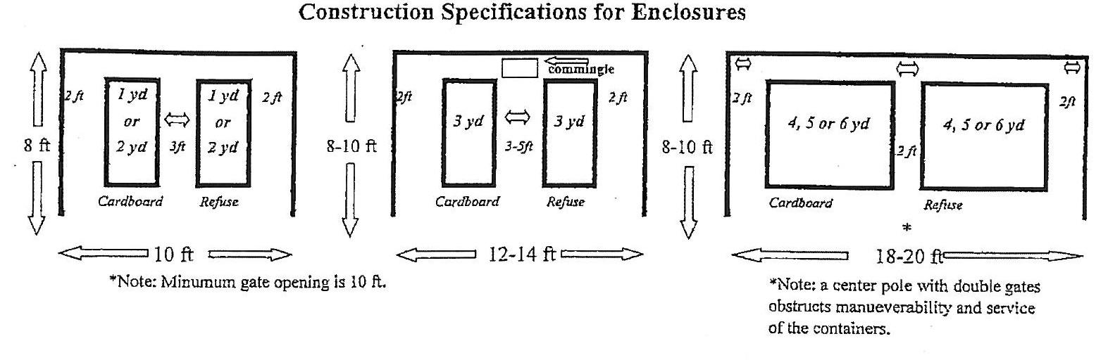
e. The area standards for trash enclosures listed insubsection (d.) above shall be met unless documentation is submitted from the applicable trash collection company indicating that an alternative design will be adequate to accommodatethe amount of refuse and recycling that is anticipated to be generated on an ordinary basis.
8. Mechanical Equipment. External mechanical equipment, such as heating or cooling equipment, pumps, or generators, that is located on the ground or on the roof of buildings, must be entirely screened from view at ground level by sight obscuring walls, fences, parapet, or other similar means consistent with the overall architecture of the development. Landscaping is not an acceptable alternative for such screening as specified herein. Screening shall be compliant with all applicable codes No heating or cooling equipment shall be placed on exterior walls unless completely screened from view.
9. Common Open Space. Common open space(s) shall be incorporated into the site plan for multi-family complexes as a primary design feature. All multi-family complex developments shall provide either 3,000 squarefeet or 15 percent of site area for open space, whichever is greater. The open space may include required setbacks areas but may not include dedicated street rights-of-way and land dedicated toother public uses like parks and schools. The Community Development Director, or designee, may require this area tobe protectedfrom streets, parking areas, or the like, by a fence or the equivalent. Sensitive lands and historic buildings or landmarks open to the public and designated by the Comprehensive Plan may be counted toward meeting the common open space requirements.
The open space provided must be landscaped inthe active or passive park style, shall include amenities such as pedestrian paths, lighting, and trash receptacles. If the common open space is landscaped as an active style park, it may be of any size provided it meets the requirements of this subsection and shall notbe subject tothe irrigated turf restrictions of Section 8.0530(G). Additionally, all multi-family complexes with 20 or more units shall provide twoor more amenities for the residents as listed below. Such amenities shall be centrally located for amajorityof the residents.
a. Tot lot/play structure
b. Community garden
c. Picnic tables/barbecue areas
d. Swimming pool, splash pad, or other water feature
e. Indoor recreation facility
f. Sports courts (i.e., basketball, tennis, volleyball)
g. Other active or passive recreation area that meets the intent of this standard as approved through the development review process.
10. Private Open Space. Private open space accessible from interior shall be required for all triplexes and quadplexes based on the following standards:
a. Ground/bottom floor housing units shall havefront or rear patios or decks at least 4 feet deep and measuring at least 48 square feet in area.
b. A minimum of 50% of allupper floor (second floorand above) housing units shall havebalconies or porches at least 4 feet deep and measuring at least 48 squarefeet in area.
c. To the maximum extent possible, private open space areas shall be oriented toward common open space areas and away from adjacent single family residences, parking areas and driveways and trash enclosures.
11. Special Yards. In order to allow air circulation and light, the distance between buildings on the same lot shall be as follows:
a. All front and rear walls, and all walls with a primary entrance shallbe separated from all other walls on all other buildings on the same lot by a minimum of 20 feet.
b. The distance between side walls on buildings on the same lot shall be no less than 12 feet.
12. Storage. Allmultifamily dwellings and complexes shall provide for storage of furniture, tools, equipment, building materials or supplies belonging to the occupants or management of the complex. Eachdwelling unit shall have one assigned, securablestorage area, aminimum 18 square feet, but shall be of a minimum size and dimension that is suitable to accommodate one bicycle of average size. Storage areas may be indoor, such as attached or detached garages, or within specific areas what are internal to each dwelling unit. Storage areas may also be within outdoor structures such as within a separate storage building located on premises. The City may exempt or reduce the storage space requirement for “specialty housing”, such as senior housing or for housing for long-term infirm care.
13. Off-Street Parking. Alloff-street parking provisions addressed herein (including: number of spaces; loading areas; and design and improvement standards) shall be provided in conformance withSection 8.0500 through 8.0515. Plexes shall comply with the City’s access policies regarding vehicle access and provide adequate pedestrian ways tosafely navigatethe parking areas and to connect to the public sidewalks. Adequate internal vehicle access shall be designed to minimize or eliminate vehicle/vehicle or vehicle/pedestrian conflicts in off-street parking areas. If off-street parking areas are proposed to be placed between the primary building elevations and public streets, the application shall be subject to apublic hearing pursuant to Article II – Land Use Procedures, Sections 8.1000 through 8.1720.
F. Exterior Mechanical Equipment. These shall be screened so as not to be visible from public streets or residences and not placed on exterior walls unless fully screened.
G. Surfacing. Gravel is prohibited as a surfacing material in the commercial or mixed use zones. Areas that are not part of the required landscaped areas shall be surfaced with asphalt or concrete unless natural, undisturbed open areas.
H. Building Design for Automotive Service Stations. The entrance to the service bays shall not be open to the street but shall be so designed to face the rear or interior side property line.
I. Retail, Office, Commercial and Mixed Use Buildings in the MUN and MUE zones.
1. Building Entrances and Orientation. At least one entrance (not including emergency exit) of any building shall be oriented toward the street and the main entrance shall be accessed directly from a public sidewalk. Primary building entrances shall be clearly defined and recessed or framed by a sheltering element such as an awning, arcade, or portico for weather protection.
2. Entries to retail, office, and mixed-use buildings in the MUN zone shall be at sidewalk level.
3. Entryways. Retail, office, commercial and mixed-use buildings in the MUN zone shall have clearly defined, highly visible customer entrances that include at leastthree of the following elements, listed below.
a. Recesses/projections;
b. Arcades;
c. Raisedcornicedparapetsoverthedoor;
d. Peakedroofforms;
e. Arches;
f. Outdoorpatios;
g. Architectural details such as tile work and moldings that are integrated intothebuildingstructureanddesign;
h. Integral planters or wing walls that incorporate landscaped areas and/or placesforsitting.
4. For buildings located at the corner of street intersections, one of the three treatmentsisrequiredtoemphasizetheimportanceofthislocationinthedistrict.
a. Locate the primary entry to the building at the corner of the building or within25feetofthecornerofthebuilding.
b. Incorporateprominentarchitecturalelements,suchasincreasedbuilding height or massing, a cupola, a turret, or a pitched roof, at the corner of thebuildingorwithin25feetofthecornerofthebuilding.
c. Chamfer the corner of the building (i.e., cut the corner at a 45-degree angle and a minimum of 10 feet from the sidewalk corner) and incorporate include extended weather protection (arcade or awning), specialpavingmaterials,streetfurnishings,orplantingsinthecut.
5. Facade Transparency. The main front (street-facing) elevation(s) shall provide at least 50% windows or transparency at the pedestrian level. The side elevations shall provide at least 25% transparency. The transparency is measured in lineal fashion (For example, 100-foot-long building elevation shall have at least 50 feet (50% of 100 feet) of transparency in length).
6. Minimum wall articulation, side or rear walls that face walkways may only include false windows and door openings defined by frames, sills and lintels, or similarly proportioned modulations of the wall, only when actual doors and windows are not feasible because of the nature of the use of the building.
7. Facade Treatment
a. Minimum Wall Articulation.
i. Facades shall add architectural interest and variety and avoid the effect of a single, long, or massive wall with no relation to human size. No wall that faces a street or connecting walkway shall have a blank, uninterrupted length exceeding 30 feet in the MUN Zone without including, but not be limited to, at least two of the following:
(a) Change in plane,
(b) Change in texture or masonry pattern, (c) Windows, trellises withvines, or (d) An equivalent element that subdivides the wall into human scale proportions.
ii. Facades greater than 100 feet in length, measured horizontally, shall incorporate wall plane projections or recesses having a depth of at least 3% of the length of the facade and extending at least 20% of the length of the facade. No uninterrupted length of any facade shall exceed 100 horizontalfeet.
iii. Ground floor facades that face public streets shall have arcades, display windows, entry areas, awnings, or other such features along no less than 50% of their horizontal length.
iv. Ground floor facades that face public streets shall incorporate at least twoof thefollowing elements:
(a) Canopies or overhangs (5’-0” minimum, measured from either the face of the column or the street-facing elevation) for the width of the building;
(b) Transom window;
(c) Storefront frieze, horizontal sign band, or a belt course above the transom window or mezzanine level;
(d) Window plant box (minimum of one per window);
(e) Projected window sill (12” to 24” above grade).
v. Building facades must include a repeating pattern that includes any one or more of the following elements:
(a) Color change;
(b) Texture change;
(c) Material modulechange.
vi. Facades shall have at least one of elements subsections (8)(a)(ii), (iii) or (iv) of this section repeat horizontally. All elements shall repeat at intervals of no more than 30 feet, either horizontally or vertically.
b. Common concrete masonry unit (CMU) is prohibited (textured CMU is allowed).
c. All sides of the building shall include materials and design characteristics consistent with those on the front. Use of inferior or lesser quality materials for side or rear facades shall be prohibited.
d. Trellises, canopies, and fabric awnings may project up to five feet into front setbacks and public rights-of-way, provided that the base is not less than eight feet at the lowest point and no higher than ten feet above the sidewalk. Awnings shall be no longer than a single storefront unless multiple storefronts exist. If multiple storefronts exist, trellises, canopies, and fabric awnings shall create uniform
cover without breaks.
8. Roof Treatments
a. All facades shall have a recognizable “top” consisting of, but not limited to:
i. Cornice treatments, other than just colored “stripes” or “bands,” with integrally textured materials such as stone or other masonry or differently colored materials; or ii. Sloping roof withoverhangs and brackets; or iii. Stepped parapets;
iv. Special architectural features, such as bay windows, decorative roofs and entry features may project up to three feet into street rights-of-way, provided that they are at least nine feet above the sidewalk.
5. Landscaping. See Section 8.0520 through 8.0540 for applicable landscaping standards.
6. Mobile Food Pods.
A. Applicability. Mobile Food Pod Site and Design review shall be required for any new Mobile Food Pod development. An alteration to a site of, or an addition of a Mobile Food Unit to an existing Mobile Food Pod, is subject to a Minor Alteration pursuant to Section 8.1400(2). Theseprovisions do not apply to:
1. A Mobile Food Unit approved and permitted through a Temporary Use Permit, Section 8.0380.
2. A Mobile Food Vendor on private or public property.
B. General Requirements. The following provisions apply to all Mobile Food Units within a Mobile Food Pod. Mobile Food Units shall:
1. Obtain a valid City business license and operational permit from Redmond Fire and Rescue.
2. Sell primarily food and/or beverage items.
3. Be maintained in a neat and clean condition including but not limitedto:
a. Regular maintenance and cleaning of the exterior of the Mobile Food Unit to avoid rust and peeling paint.
b. Repair of broken or sagging awnings, canopies, platforms, counters, benches, tables, seating, umbrellas, and other structures.
4. Not dump wastewater onto the ground, onto the streets, or into a storm drainage facility. All liquid waste from the waste tank or from cleaning activities such as cleaning the Mobile Food Unit, shall be captured, and properly disposed, except as approved by the City Engineer. Discharge or leakage draining intothe stormwater system is prohibited.
5. Be placed on an impervious surface such as asphalt, concrete, pavers, or other surface as approved by the City Engineer. Spills shall be cleaned and disposed of properly.
6. Provide vehicular access pursuant to Section 8.2820, Access Management Standards, and per Public Works Standards andSpecifications.
7. Provide permanent restrooms with hand-washing stations and located within 250 feet of the Mobile Food Pod. No portable bathrooms are allowed onsite.
8. Connect to a public water and sewer or other approved permanent source, as required in City Code, Chapter 4, and conforming to Public Works Standards and Specifications, unless exempted by the City Engineer.
9. Connect to a permanentpower source:
a. Power connections may not be connected by overhead wires or extension cords toindividual Mobile Food Units.
C. Design Standards. The following provisions apply to all Mobile Food Units within a
Mobile Food Pods.
1. Mobile Food Units shall not be located in the right-of-way and are only permitted on the subject property. Equipment, customer queue, or any accompanying items shall not be located within the right-of-way, clear vision areas, or sight distanceareas.
2. Mobile Food Units shall ingress and egress from an approved access point conforming to Public Works Standards and Specifications and must be kept clear and free from obstructions.
3. Mobile Food Units shall be a minimum of five feet from other Mobile Food Units and all structures.
4. Mobile Food Units shall have a minimum setback of 10 feet from all property lines or comply with theunderlying zone setback, whichever is greater.
5. A Mobile Food Pod containing more than eight Mobile Food Units, at any time, shall have a designated loading area. The loading area shall be provided with paved access, driveways and surfacing in the same manner as for off-street parking, except that each space shall be 10 feet wide and 22 feet long with a height clearance of at least 14 feet. A sight-obscuring screen shall conceal the loading area from view from public streets.
6. Mechanical or power-generating equipment located outside the Mobile Food Unit shall be concealed with screening at a height equal to or exceeding that of the equipment.
7. Any proposed fencing shall not be constructed of chain link and shall comply with Section 8.0340.
8. A minimum of at least 300 square feet of open space per Mobile Food Unit shall be provided for queuing, eating, and communal space.
9. Each Mobile Food Unit shall have an assigned, securable, interior storage area that is a minimum of 20 square feet.
10. Trash receptacles for the disposal of solid waste shall be provided in convenient, secure, and concealed locations and be of such capacity so that there is no accumulation of uncovered trash at any time. Solid waste shall be removed from the property on a scheduled basis to prevent health hazard or nuisance.
11. Deviation from any of the above standards may be granted administratively by the Community Development Director, or designee, provided extenuating circumstances.
7. Parking and Unloading Areas/Docks.
A. Off-Street Parking Areas. Parking areas shall be as near the public entrances to the structure served as possible.
B. Parking lot. The parking shall be dispersed around the building, emphasizing the importance of the building and accessibility to entrances. In the MUN and MUE zones, parking shall be located to the side, rear, or under the building or in a designed central parking lot.
C. Truck loading areas or docks. Truck loading areas or docks, where delivery is done by semi truck with a specified loading dock, shall be located or screened from the street or from the major public entrance to the building. The Applicant shall identify the specific type(s) and size of delivery vehicles which will deliver and/or take goods to/from the building; the hours of delivery, the location of delivery doors and their dimensions. Truck loading areas or docks shall not inhibit circulation onsite or create access problems from adjacent streets.
8. General Site Criteria.
A. Grading and Drainage.
1. Grading. Grading shall conform to the City of Redmond Public Works Standards and Specifications.
2. Drainage and Stormwater. Drainage shall be maintained in conformance with the Public Works Standards and Specifications. A stormwater drainage plan shall be developed in conformance with the Public Works Standards and Specifications.
3. Blasting. A permit for explosive blasting shall be obtained from Redmond Fire & Rescue and City Engineer prior to blasting.
B. Clear Vision Standard. The plan must conform to Section 8.0305, Establishment of Clear Vision Areas.
C. Trash Collection Areas. Trash collection areas shall not be oriented towards building entrances or public streets other than alleys and shall be screened or enclosed with building material which is compatible with those used in the exterior of the building. Location(s) of all trash collection area(s) shall be reviewed and approved by the Community Development Department Director, or designee.
D. Water and Sewer Service. Connection to the City’s public water and sewer systems shall be required and shall comply with the current Public Works Standards & Specifications.
E. Accessibility. At least one pedestrian pathway, which meets UBC accessibility requirements, shall be provided within the boundary of the site from public transportation stops, accessible parking spaces, passenger loading and drop off zones, and public streets or sidewalks to an accessible entry. When more than one building or facility is located on a site, at least one accessible route shall be provided between accessible buildings and accessible site facilities. The accessible route shall be the most practical and direct route among accessible building entries, accessible site facilities and the accessible entry to the site. Walks paralleling vehicular ways shall be separated from vehicular ways by curbs, planted areas, railings, or other means between the pedestrian way and vehicular routes.
F. Streetscape standards in the MUN zone. New retail, office, commercial and mixed-use development, and major modifications (per RDC 8.3005-8.3010) within the MUN zone shall provide one or more of the Category A pedestrian amenities listed below and all of the Category B amenities, as generally illustrated in the figure below. Pedestrian amenities may be provided within a planting strip or street furnishing zone, building frontage zone or plaza, as shown in the figure below. Use of the public right-of-way requires approval by the roadway authority.
CategoryA:
1. A plaza, courtyard, square or extra-wide sidewalk next to the building entrance (minimumwidthof8feet);
2. Sitting space (i.e., dining area, benches, garden wall or ledges between the building entrance and sidewalk) with a minimum of 16 inches in height and 30 inchesinwidth;
3. Publicartthatincorporatesseating(e.g.,fountain,sculpture).
CHAPTER 8 DEVELOPMENT REGULATIONS
Figureforsubsection7.f.:PedestrianAmenitiesforstreetscape
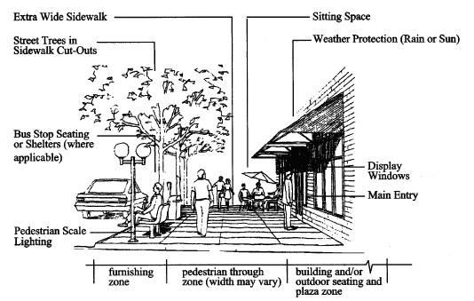
CategoryB:
1. Building canopy, awning, pergola, or similar weather protection (minimum projectionof4feetoverasidewalkorotherpedestrianspace).
2. Streettrees,asspecifiedinRDCSection8.3035(5)(k),ingrates.
3. One trash receptacle per building, for buildings wider than 40 feet at street/sidewalkfrontage.
4. Onepedestrianscalelightfixtureperbuilding.
5. Parking areas shall be located behind buildings, below buildings, or to the sides ofbuildings.
6. Neighborhood-scale signs, as specified in City Code Chapter 11, Sign Standards.
9. Transportation System Analysis (TIA). The development must meet requirements per Section 8.2815 (Transportation System Analysis).
10. Access Management Standards. The development must meet requirements per Section 8.2820 Access Management Standards.
[Section 8.3035 amended by Ord. #2009-03 passed May 26, 2009]
[Section 8.3035 amended by Ord. #2009-14 passed December 8, 2009]
[Section 8.3035 amended by Ord. #2012-04 passed April 24, 2012]
[Section 8.3035 amended by Ord. #2013-04 passed May 14, 2013]
[Section 8.3035 amended by Ord. #2015-01 passed February 24, 2015]
[Section 8.3035 amended by Ord. #2016-17 passed January 31, 2017]
[Section 8.3035 amended by Ord. #2017-12 passed December 12, 2017]
[Section 8.3035 amended by Ord. #2020-15 passed November 10, 2020]
[Section 8.3035 amended by Ord. #2022-04 passed June 28, 2022]
[Section 8.3035 amended by Ord. #2022-04 passed June 28, 2022]
[Section 8.3035 amended by Ord. #2022-09 passed December 13, 2022]
[Section 8.3035 amended by Ord. #2023-07 passed December 19, 2023]
8.3040Downtown Overlay District Design Review Criteria. In addition to the standards in Section 8.3035, prior to the issuance of a building permit, all properties, and structures in
the Downtown Overlay District, unless exempt under Section 8.3040(2) below, shall comply with the Downtown Design Standards. If a conflict exists between the Sections 8.3035, 8.3040, and 8.3045, then Section 8.3040 shall take precedence.
1. Purpose. In an effort to enhance and improve downtown’s character, thequality of the pedestrian experience, and economic vitality, the City Council has adopted architectural design standards for thedowntown core area.
The intent of the architectural design standards is to achieve the following:
A. Quality Economic Growth. Assureopportunities for a stable, vital, diverse, and competitive economy at the heart of the city.
B. Vibrant Downtown. Strengthen downtown as avibrant,mixed use district that draws a wide spectrum of residents and visitors.
C. Downtown Appearance. Improveand enhance the appearance of the built environment and natural features throughout Downtown, especially along primary commercial corridors, and other major arterials.
D. Historic Character. Preserve and retain historic structures and culturalresources throughout downtown.
E. Pedestrian Environment. Improve and enhance the pedestrian environment throughout downtown, as well as the pedestrian
2. Exempt Development. These Design Standards shall apply to any development in the Downtown Overlay District except for the following uses:
A. Minor Modifications.
B. Landscaping or landscape alterations.
C. Repair or maintenance of public or private buildings, structures and landscaping that present a risk topublic safety.
D. Maintenance of the exterior of an existing structure such as re-roofing, or re-siding where similar materials and colors are used.
E. Interior remodeling.
F. Temporary structures and uses whichare for relief of victims of disaster or an emergency.
G. Single family detached dwellings and middle housing.
H. Child Care facilities thatoperate in existing residential structures.
3. Non-exemptDevelopment. Any development in the Downtown OverlayDistrict that does not qualify as Exempt Development, including major modifications, shallmeet the applicable design standards in Section 8.3040. If a conflict exists among Section 8.3040, Section 8.3035, and Section 8.3045, then Section 8.3040 shall apply.
4. Procedure. The Community Development Director, or designee, or Hearings Body, shall approve, approve withconditions, or deny an application based upon compliance with the design standards. Approval shall be obtained from the review authority prior to the issuance of a building permit for all non-exempt development. Per the Downtown Architectural Design Standards, applicants can choose twotracks of review:
A. Track 1 –Clear and Objective: Administrative Review of Compliance with Design Standards. Track 1 requires applicants to meet the downtown design standards, including the intent and approach of each standard as noted below. The design standards are quantifiable and can be administered as part of the plan-review process. These applications are reviewed administratively by City of Redmond Planning staff.
B. Track 2 - Discretionary:City Review of Compliance with Design Standards. Track 2 allows applicants to satisfy the intent of the design standards as determined by the Hearings Body. In Track 2, the intent statements serve as the criteriafor
determining if the “intent” of the downtown design standard is being met. In Track 2, applicants are required to identify how their proposed siteand/or building meet the intent statements of the design standards, and why specific objectivestandards cannot be met.
5. Application Requirements. The applicant shallattend a pre-development meeting with City of Redmond Planning or Urban Renewal staff todetermine if the proposed development is “exempt” or “non-exempt” from the Downtown Design Standards, and to determine, if possible, if the development shouldbe processed as a Track 1 or Track 2 review. The application shall contain information specified in this Article of the Redmond Development Code, aswell as sample paint colors.
6. Approval Process. For each standard, there will be one or more approaches an applicant will need to follow to meet the design intent under Track 1. Within each approach, there may be a menu of elements or techniques that an applicant may employ. In many cases, the same elements and techniques are presented as a means to meet different standards. In the event that a specific element or technique is used to meet two standards, an applicant will be required to choose another element or technique tomeeta thirdstandard. In this way, applicants are required tomake use of multiple elements or techniques thereby increasing the attractiveness of downtown.
For Track 1, Planning Staff shallusethe downtown design standards, approaches, elements, and techniques to ensure compliancewith the intent of downtown design standards. For Track 2 applications, the City of Redmond Hearings Body shall use the intent statements to ensure compliance with the downtown design standards.
7. Downtown Design Standards. The downtown design standards establish a palette of objective, design-oriented elements that help ensurethat proposed development, redevelopment, and modifications conserves and enhances desired scaleand character of the downtown. They are intended to implement City’s goals and objectives in the Redmond Comprehensive Plan and Downtown Action Plan.
A. Standard: Cohesive Architectural Elements
Intent: Enhancethe experience of passing motorists, pedestrians, and bicyclists by incorporating cohesive and repetitive architectural elements intothe ground-floor design of street-facing façades (and alley-facing façades wherefeasible).
Approach 1: Divide the ground floor of commercial storefronts into distinct architectural bays that are no more than 30 feet on center. For the purpose of this standard, an architectural bay is defined as the zone between the outsideedges of an engaged column, pilaster, post, or vertical wallarea.
Approach 2: For eacharchitectural bay, incorporate aminimum of three of the following elements/techniques:
Element/Technique:
Building lighting (minimum of a pair)
Suspended signs / blade signs
Canopies or overhangs (5’-0” minimum, measured from either theface of the column or the street-facing elevation)
Transom window
Storefront frieze, horizontal sign band, or a belt course abovethe transom window or mezzanine level
Window plant box (minimum of one per window)
Projected windowsill (12” to24” above grade)
Architectural treatment (minimum of a pair)
Wherefeasible, building elevations that face an alley should be enhanced with a minimum of a doorway (with glass) and lighting.
B. Standard: Streetscapeand Pedestrian Amenities
Intent: Ensure that Downtown development contributes tothe creation of a cohesive, exciting, and vibrant street life. Create safe and friendly pedestrian zones, on private property, that promotes walking, shopping, and meeting with friends.
Approach: To reinforcethe pedestrian realm and create spaces where people are encouraged to gather, implement one of the four space-making elements/techniques below.
Element/Technique:
Courtyard: Incorporatea smallcourtyard intothe design of street facing and/or alley-facing façades that includes transparent windows and/or doors, exterior lighting, and special paving.
Wherepossible, windows should be incorporated into all walls that face the courtyard. Thesewindows should be large enough to encourage interaction between inside and outside. Other elements thatshould be considered in the design of courtyards are benches, planter boxes, trees, and bike racks.
Recessed Entry: Create a small, covered transition zone between the sidewalk and the front door. Define this space with special lighting, paving, and storefront windows.
Chamfer Entry: Createa gathering place at the corner of the building by chamfering the corner of the building (i.e., cutting the corner at a 45-degree angle for a minimum of 10’-0” on each side of thecorner).
Arcade: Set the front door tothe building a minimum of 5’-0”(clear) behind an arcade that is located at the front property line or the adjusted property line.
Provide architectural and/or structural vertical columns at an interval that does not exceed 20’.
C.
Standard: Human Scale
Intent: Design building façades to a “human scale” – with details, materials, and workmanshipthat is aesthetically appealing as well as comfortablefor, and at the scale of, pedestrians.
The most successful ground floor street elevations exhibit a high degree of transparency and consist of a palette of well-designed elements that are scaled to the human body. To continue this tradition, applicants shall select elements for each of the horizontal building divisions that comprisethe ground floor façade as described below.
Approach 1: The base of the ground floor façadeextends from the top of the finished grade or sidewalk to the bottom of the windowsill. To continue this development pattern, select at least one of the following elements/techniques:
Element/Technique:
Defined base of an engaged column or pier
Projected windows sills (12-24” above grade)
Note: “Human Scale” in architecture considers how people interact withthe built environment based upon their physical dimensions and capabilities. Besides anthropometric (human) measurements, human scale looks at the visual,acoustic, and spatial properties of a space and scales those properties torelate to the human form.
Note: The area below the projected windowsill is commonly referred to as a bulkhead, window base, or window panel. This zone is usually constructed of concrete, brick, stone, or wood and servesto anchor the façade to the ground floor plane. With the exception of the entry door, this base element usually extends the length of the elevation.
Approach 2: Storefront windows typically framethe middle of the ground floor façade. To continue this development pattern, select at least one of the following elements/techniques:
Element/Technique:
Medallion (minimum of a pair)
Window plant box (minimum of one per window)
Integrated horizontal and vertical window mullions
Approach 3: The top of the ground floor façade is the area between the storefront and the upper stories of the building. To continue this development pattern, select at least one of the following elements/techniques:
Element/Technique:
A marquee or suspended sign / blade sign that extends (perpendicular) from the building façade (the bottom of the marquee or sign shall be 8-12 feet above grade) (See Section 8.4180(5)).
Sign frieze
Storefront awning or canopy (the bottom of the awning or canopy shall be at least 8feet abovegrade, and no higher than the 1st floor of the building or 15 feet above grade whichever is less. Minimum clearance below an awning on which signage is hung or displayed is 8 feet from the sidewalk or ground level to the lowest portion of the awning or suspended sign whichever is lowest.)
Storefront cornice / belt course
Transom window(s)
D. Standard: Weather Protection
Intent: Protect pedestrians from sun, wind, and rain.
Approach: Provide weather protection along 50% of the ground floor façade (50% of the linear frontage abutting a right-of-way) by incorporating one of the following elements/techniques:
Element/Technique:
Awnings (glass, metal, or fabric)
Balconies
Building overhangs (including recessed entries)
Arcade
The depth of all canopies and awnings shall be a minimum of 5’-0”,measured from either the face of the column or the street facing elevation, unless limited by the building code. Internalillumination (underlighting) is prohibited unless the awning is made of an opaque material.
Note: Arcades are strongly encouraged along full-block developments.
E. Standard: Pedestrian-Oriented Ground Floor
Intent: Design street and sidewalk-facing storefronts and entries to be inviting and easily accessible to passersby. Ensure that the ground floor promotes a sense of interaction between activities in the building and activities in the public realm.
Approach: Create aprominent entry and foster interaction between inside and outside by incorporating three or more of the following elements/techniques:
Element/Technique:
Overhangs (canopies, awnings)
Clerestory or transom window as part of the large storefront system
Glass windows that flank the door
Decorative lighting
Large glass entry doors
Creative signage
Artwork
Recessed entry bay
Incorporating paving and color
The depth of all canopies and awnings shall be a minimum of 5’-0”,measured from either the face of the column or the street facing elevation.
Applicants arestrongly encouraged to use earth tones or muted colors.
The use of mirrored or tinted glass is prohibited.
F. Standard: Tri-Partite Façades
Intent: To enhancethe image of the downtown by creating an attractive and unified building façade that reflects and complements Redmond’s historic buildings and celebrates ground floor activities, the top of the building (where the edificemeets the sky), and everything in between. To ensure the design of a unified and cohesive building façade, applicants shalldesign building façades consisting of a clear and distinct base, middle, and top. This standard shall apply to buildings of all heights (or number of stories).
Approach 1: Base. The base of the building typically extends from the sidewalk to the bottom of the second story or the belt course/ string course that separates the ground floor from the middle of the building. In order to enhance the character of the base of the building, applicants shall include inthe design of the façade at least one of the following elements/techniques.
Element/Technique:
Storefront windows
Canopies or awnings (5’-0” minimum, measured from either the face of the column or the street facing elevation)
Distinct architectural bays
Entry overhang
Large floor-to-floor heights
Approach 2: Middle. Distinguish the middle of the building from the top and base of the building by incorporating one of the following elements:
Element/Technique:
Change in color
Balconies
Change in windows
Step backs
Signage
Horizontal band(s). Horizontal bands shall be aminimum of 8” high (the length of astandard brick) and can beformed bya change in material, a change in color, brick orientation, or, preferably, by projecting materials from the face of the building.
Note: Where possible, windows should express the use inside the building. For example, second story residential windows are often times oriented vertically with a width to height relationship of 2:1.
Approach 3: Top. All building façades shall havea “cap” element at the uppermost portion of the façade that visually terminates the façade. Tocreatevisual interest at the top of the building, applicants shall incorporate one of the following three elements/techniques.
Element/Technique:
Detailed cornice or projected parapet
A roof form, other than aflat roof, that projects beyond the face of the building
Roof top garden that consists of plant materials that are visible from the sidewalk and the street.
Note: Besides being attractive, the incorporation of a roof top garden has the added benefit of helping to manage storm water run-off that would otherwise go intothe ground water.
G. Standard: Materials
Intent: Use building materials and construction practices that evoke a sense of permanence and arecompatible with Redmond’s historic buildings.
Approach: Incorporateone of the following building materials, found on traditional commercial storefronts, into the design of the ground-floor (street facing) façades:
Brick
Metal
Terra cotta
Stone
Concrete (and CMU)
Stucco
Horizontal wood or cementitious siding
Wood shingles
Board and batten verticalwood siding
Ceramic detail
Prohibited Building Materials: The following materials are prohibited:
T-11 or similar sheet materials
Stucco clad foam (EIFS)
Vinyl siding
Log construction
Mirrored or tinted windows (except for that which is required by code).
Note: Where possible, use materials indigenous to CentralOregon.
Note: Concrete and wood siding should be painted using a palette of earth tone or muted colors.
H. Standard: Reinforce the Corner
Intent: Create dynamic public gathering spaces where streets intersect. Enhance way-finding and the comprehension of Downtownby making recognizableand memorable design elements at the corner of each block.
Approach: Chooseone or more of the following elements/techniques tomake intersections exciting places for people to gather.
Element/Technique:
Locate the primary entry to the building at the corner of the building or within 25’ of the corner of the building.
Incorporate prominent architectural elements, such as increased building height or massing, a cupola, a turret, or a pitchedroof, at the corner ofthe building or within 25-feet of the corner of the building.
Chamfer the corner of the building (i.e., cut the corner at a 45-degree angle and a minimum of 10’-0” from the corner of the property line) and incorporatea combination of special paving materials, street furnishings, and plantings.
Note: Where possible, incorporate double storefront doors that include large expanses of glass.
I. Standard: Color
Intent: Color a very important ingredientfor enlivening and enhancing the built environment. A building’s color should accentuate and harmonizewith its architecture, as well as complement surrounding structures.
Approach: The color of any structure shall comply with all of the following criteria:
Be compatible with the existing built environment. A building’s color should not competefor attention with neighboring buildings.
Limit the useof toomany colors on a single building. Typically, three colors are sufficient to create asuccessfulfaçade; richer or deeper hues should be used to accent door andwindow trim and other, smallarchitecturaldetails.
On primary façades visible from public streets, use warm, more muted colors that have low reflectivity and complement the natural colors found in the surrounding landscape. Where possible, street-facing façades should consist of unadorned materials such as brick, stone, stucco, and wood shingles.
Avoid the use of bright colors (such as primary or neon colors)that have intense and bright hues.
[Section 8.3040 amended by Ord. #2020-15 passed November 10, 2020]
[Section 8.3040 amended by Ord. #2022-04 passed June 28, 2022]
8.3045C-2 Central Business District Commercial Design Review Criteria
In addition to the standards in Section 8.3035, prior tothe issuance of abuilding permit, all properties in this zoning district, except single use residential structures, shallcomply with the standards in this section. If a conflict exists between the Sections 8.3035 and 8.3045, then Section 8.3045 shall take precedence.
1. Façade Treatment.
A. Minimum Wall Articulation.
1. Façades shall add architectural interest and variety and avoid the effect of a single, long, or massivewall with norelationto human size. No wall that faces a street or connectingwalkway shall haveablank, uninterrupted lengthexceeding 30feetwithoutincluding,butnotbelimitedto,atleasttwoofthefollowing: a. Changeinplane, b. Changeintextureormasonrypattern, c. Windows,trelliseswithvines,or
d. An equivalent element that subdivides the wall into human scale proportions.
2. Façadesgreaterthan100feetinlength,measuredhorizontally,shallincorporate wall plane projections or recesses having adepthof at least 3% of the length of the façade and extending at least 20% of the length of the façade. No uninterruptedlengthofanyfaçadeshallexceed100horizontalfeet.
3. Ground floor façades that face public streets shall have arcades, display windows,entryareas,awnings,orothersuchfeaturesalongnolessthan50%of theirhorizontallength.
4. Building façades must include a repeating pattern that includes any one of more of the following elements: a. Color change;
b. Texturechange;
c. Material modulechange.
5. Side or rear walls that face walkways may only include false windows and door openings defined by frames, sills and lintels, or similarly proportioned modulations of the wall, only when actualdoors and windows are not feasible because of the nature of the use of the building.
2. Entryways. Commercial buildings shall have clearly defined, highly visiblecustomer entrances including at least three of thefollowing elements, listed below.
A. Recesses/projections;
B. Arcades;
C. Raisedcornicedparapetsoverthedoor;
D. Peakedroofforms;
E. Arches;
F. Outdoorpatios;
G. Architecturaldetailssuchastileworkandmoldingswhichareintegratedintothebuilding structureanddesign;
H. Integral planters or wing walls that incorporate landscaped areas and/or places for sitting.
3. ReinforcingtheCorner: Forbuildingslocatedatthecornerofintersections,oneofthethree treatmentsisrequiredtoemphasizetheimportanceofthislocationinthedistrict.
A. Locatetheprimaryentrytothebuildingatthecornerofthebuildingorwithin25feetof thecornerofthebuilding.
B. Incorporateprominentarchitecturalelements,suchasincreasedbuildingheightor massing,acupola,aturret,orapitchedroof,atthecornerofthebuildingorwithin25 feetofthecornerofthebuilding.
C. Chamferthecornerofthebuilding(i.e.,cutthecornerata45-degreeangleanda minimumof10feetfromthesidewalkcorner)andincorporateincludeextendedweather protection(arcadeorawning),specialpavingmaterials,streetfurnishings,orplantingsin thecut.
4. Materials:
A. Incorporateoneofthefollowingbuildingmaterialsintothedesignofthegroundfloor (street-facing)façades: brick,metal,terracotta,stone,concrete,stucco,horizontal woodorcementitioussiding,woodshingles,boardandbattenverticalwoodsiding, ceramicdetail.
B. ProhibitedMaterials: T-111orsimilarsheetmaterials,stuccocladfoam(EIFS),or commonconcretemasonryunits(CMU).
C. All sides of the building shall include materials and design characteristicsconsistent with those on the front. Use of inferior or lesser quality materials for side or rear façades shall be prohibited.
D. Trellises, canopies, and fabric awnings may project up to five feet into front setbacks and public rights-of-way, provided that the base is not less than eight feet at the lowest point and no higher than ten feet above the sidewalk. Awnings shall be no longer than a single storefront unless multiplestorefronts exist.
5. RoofTreatments.
A. Allfaçadesshallhavearecognizable“top”consistingof,butnotlimitedto: 1. Cornice treatments, other than just colored “stripes” or “bands,” with integrally textured materials such as stone or other masonry or differently colored materials;or
2. Slopingroofwithoverhangsandbrackets;or 3. Steppedparapets;or
CHAPTER 8 DEVELOPMENT
4. Special architectural features, such as bay windows, decorative roofs and entry features may project up to three feet into street rights-of-way, provided that they areatleastninefeetabovethesidewalk.
6. Streetscapestandards. Newcommercialormixed-usedevelopmentandmajormodifications shallprovidestreetscapeamenities,asgenerallyillustratedinthefigurebelow. Pedestrian amenitiesmaybeprovidedwithinaplantingstriporstreetfurnishingzone,buildingfrontage zoneorplaza,asshowninthefigurebelow.Useofthepublicright-of-wayrequiresapprovalby CityofRedmondandmustcomplywiththeRedmondDowntownRightofWay(ROW) StandardsandSpecifications.
Figure;PedestrianAmenitiesforstreetscape
Amenities:
A. Buildingcanopy,awning,pergola,orsimilarweatherprotection(minimumprojectionof4 feetoverasidewalkorotherpedestrianspace).
B. Streettrees,asspecifiedinRedmondDowntownROWstandards.
C. TrashReceptaclesforbuildingswiderthan40feetatstreet/sidewalkfrontageasper RedmondDowntownROWstandards.
D. DecorativepedestrianscalelightfixturesasperRedmondDowntownROWstandards.
E. Parkingareasshallbelocatedbehindbuildings,tothesidesofbuildingsorbelow buildings.
F. Pedestrian-scale signs, as specified in Article V. Sign Standards for properties in the C-2 Central Business District Commercial Sign Standards.
8.30410 Master Plans.
[Section 8.30410 deleted by Ord. #2009-04 passed April28, 2009]
8.3050 Partial Master Development Plans. When the development proposed is for less than the entire site a partial master development plan may be required. In addition to providing all plans associated with Site and Design review, a partial master plan shallalso clearly show
CHAPTER 8 DEVELOPMENT REGULATIONS
the project area and shall clearly identify the timing of each specific phasewithin the master plan, if phases are proposed.
[Section 8.3050 added by Ord. #2009-04 passedApril 28, 2009]
[Section 8.3050 amended by Ord. #2015-01 passed February 24, 2015]
[Section 8.3050 amended by Ord. #2020-15 passed November 10, 2020]
SITEAND DESIGNREVIEW FOR LIVE/WORKUNITS
8.3100Site and Design Review for Live/ Work Units.
[Section 8.3100 added by Ord. #2011-09 passedNovember 8, 2011]
8.3110Purpose and Intent. The Live/Work Unit is a new combined form of living unit which can provide the necessities and comforts of home and provide a venue for a source of income to promote the success of the owner. In order for these units to be approved as new or modified units, new construction must be well-designed, architecturally interesting, and made of quality products.
[Section 8.3110 added by Ord. #2011-09 passedNovember 8, 2011]
8.3120ApplicabilityofSite and Design Review and Modified Site and Design Review. Site and Design Review shall be required to establish any New Live/Work Unit.
1. Modified Site and Design Review shall be required for a Modified Live/Work Unit for any of the following:
A. The change of use or building addition to add a business component (more intensive than a home occupation) to aresidential property.
B. The change of use or building addition to add a residential use to a business property.
2. Exemptions from Site and Design review for Modified Live/Work Units may be allowed if the Community Development Director, or designee, determines with findings that the proposed development will have a negligible impact on the neighborhood.
[Section 8.3120 added by Ord. #2011-09 passedNovember 8, 2011]
8.3130Zoning Applicability. Live/Work Units that comply with Section 8.0260 are a permitted use in theMixed Use Live Work (MULW) zone.
[Section 8.3130 added by Ord. #2011-09 passedNovember 8, 2011]
8.3140Procedure. A Site and Design Review application for a Live/ Work Unit shall be submitted to and reviewed by the Community Development Director, or designee, as a Land Use action as described in Section 8.1300. A pre-development meeting is required prior to submitting a Site and Design Review application.
[Section 8.3140 added by Ord. #2011-09 passedNovember 8, 2011]
[Section 8.3140 amended by Ord. #2020-15 passed November 10, 2020]
[Section 8.3140 amended by Ord. #2023-07 passed December 19, 2023]
8.3150Site Improvement Agreement. Upon approval the applicant/owner, at the City’s discretion, shall enter into a Site Improvement Agreement, which states the applicant/owner shall abide by the decision and conditions of approval for the Live/Work Unit.
[Section 8.3150 added by Ord. #2011-09 passedNovember 8, 2011]
8.3160Plans Required. The applicant shall submit to the Community Development Department the following documents with the required fee.
1. Exterior elevations. Drawings or sketches of elevations for all sides of the proposed building(s). Such plans shall indicate the building height, primary building materials, color, shape, architectural features, and other design features of the building, including the location of all exterior mechanical devices.
2. Site Plan. Site plans containing the following.
A. A drawing showing the floor plans for each building and a description of each internal “use.”
B. Location and use of all proposed and existing buildings, fences, and structures within the proposed development. Indicate which buildings are to remain and which areto be removed.
C. Location of all parking areas and dimensions of all parking spaces (existing and proposed).
D. Location and size of all existing & proposed public utilities serving the subject property including water lines, sewer lines, storm drains, power poles and lines, telephone poles and lines, and existing firehydrants.
E. Location of existing drainage on-site, canals and laterals.
F. Location of all utility and access easements on the property.
G. Locations of all existing natural features including, but not limited to, any existing trees having a six (6) inch trunk diameter or greater, three (3) feet above grade, and any significant natural features including (but not limited to) outcroppings of rocks, boulders, etc. Indicate any contemplated changes that would affect a natural feature.
H. Photograph of building(s) and site.
3. Landscape Plan. See Section 8.0520 through 8.0540 for applicable landscaping standards.
4. Lighting Plan. A lighting plan showing the type, placement, wattage, and method of shielding all exterior lights from adjacent sites shall be submitted.
[Section 8.3160 added by Ord. #2011-09 passedNovember 8, 2011]
[Section 8.3160 amended by Ord. #2023-07 passed December 19, 2023]
8.3170Site and Design Review Criteria. Prior to issuance of a building permit, the following applicable criteria shall be met.
1. Dimensional Standardsfor New Live/Work Units.
A. Minimum Work Space. Each New Live/Work Unit shall have a minimum work space of 200 squarefeet.
B. Minimum Living Area. Each New Live /Work Unit shall have a minimum living area of 600 squarefeet.
2. Outside Requirements.
A. Parking. Each live/work unit shall have one (1) off-street parking space for each dwelling unit and one (1) off-street parking space for the first 1,000 square feet of non-residential floor area. Additional off-street parking spaces for non-residential floor area over and above the first 1,000 square feet shall be provided pursuant to Section 8.0500 through 8.0515 (Off-Street Parking and Loading Requirements). The applicant may propose approved materials for parking that are porous and yet strong enough to support vehicles. The Community Development Director, or designee, shall be the final authority for acceptable alternatives to pavement.
B. Exterior Mechanical Equipment. Exterior mechanical equipment shall be screened so as not to be visible from public streets.
C. Installation of Utilities. All new utility service lines serving the site shall be placed underground, unless otherwise approved by theCommunity Development Director.
D. Landscaping. See Section 8.0520 through 8.0540 for applicable landscaping standards.
E. Grading and Drainage. All site drainage shall be maintained on site and shall not drain ontopublic streets, irrigation canals/ditches or neighboring properties.
F. Outdoor Storage. All outdoor storage shallbe screened to aminimum of six feet in height.
G. Fencing. Fencing standards for residential zones described in 8.0340 shall apply to Live/Work Units.
H. Trash Collection. Trash collection areas in which 1 yard or larger containers are located shall be screened from public view or in a trash enclosure. Trash enclosures shall be constructed of materials similar and matching to the subject building.
I. Lighting. Artificial Lighting shall not shine off-sitegreater than 0.5-foot candles.
3. Architectural Requirements for New Construction. New Live/Work Unit shall comply with the following standards.
A. Architectural Consistency. Each New Live/Work Unit shall have consistent architectural elements present on all of the facades.
B. Flat, Unbroken Walls. Single, long, or unbroken flat walls shall be avoided. Each New Live/Work Unit shall have a change of plane and change of material on the main facades (street visible) of the building.
C. Recessions and Projections. Each unit shall have architectural recessions and projections not less than2 inches in change.
D. Transparency (windows or glass block-type elements). Each unit shall have a minimum of 25% transparency of the total square footage of the street-facing façade on the first floor of the business portion of the unit.
E. Change in texture or masonry pattern. Two or more finishing products or masonry patterns on theelevations of each unit is required.
F. Building Entrance. Each unit must have a primary ground floor entrance on the street-facing façade withassociated pedestrian access to the public right of way.
G. Prohibited Materials. The New Live/Work Unit shall not use the following building products, T-111, Exterior Insulation and Finishing System (EIFS), continuous corrugated metal (30 gauge or lighter). Use of metal cargo shipping containers for residential use is prohibited.
4. Additional Architectural Requirements. Each of the New Live/Work Unit shall have a minimum of 2 of the following:
A. Change in color.
B. Canopies or overhangs (with aminimum projection depth of 2feet).
C. Display windows (projected or recessed).
D. Roof Treatments.
E. Outside patio or seating area.
F. Other elements of architectural interest. The applicant may propose an unlisted type of architectural feature or elements as permitted by the Community Development Director.
5. Modifications to Existing Structures. To convert an existing structure to a Live/Work Unit, the following applicable criteria shall be met.
A. Dimensional Standardsfor theModified Live/Work Unit.
1. Minimum Work Space. Each Live/Work Unit shall have a minimum work space of 200 squarefeet.
2. Minimum Living Area. Each Live /Work Unit shall have a minimum living area of 600 squarefeet.
B. Outside Requirements.
1. Parking. Each live/work unit shall have one (1) off-street parking space for each dwelling unit and one (1) off-street parking space for the first 1,000 square feet of non-residential floor area. Additional off-street parking spaces for non-residential floor area over and above the first 1,000 square feet shall be provided pursuant to Section 8.0500 through 8.0515 (Off-Street Parking and Loading Requirements). The applicant may propose approved materials for parking that are porous and yet strong enough to support vehicles. The Community Development Director, or designee, shall be the final authority for acceptable alternatives to pavement.
2. Exterior Mechanical Equipment. Exterior mechanical equipment shall be screened so as not to be visible from public streets.
3. Landscaping. See Section 8.0520 through 8.0540 for applicable landscaping standards.
4. Outdoor Storage. All outdoor storage shall be screened to a minimum of 6 feet in height by avegetative hedge, solid fencing, or on-site buildings.
5. Fencing. Fencing standards for residential zones described in 8.0340 shall apply to Live/Work Units.
6. Trash Collection. Trash collection areas in which 1 yard or larger containers are located shall be screened or in a trash enclosure. Trash enclosures shall be constructed of materials similar and matching to the subject building.
7. Lighting. Artificial Lighting shall not shine off-site greater than 0.5-foot candles.
C. Architectural Requirementsfor the Modified Live/Work Unit.
1. Architectural Consistency. Each Modified Live/Work Unit shall have consistent architectural elements present on each of the facades.
2. Exterior Walls. Any exterior wall or surface area that has more than thirtythree percent (33%) of its total area bare, peeling, flaking, pitted, corroded, or otherwise deteriorated, as determined by the Community Development Director, or designee, shall be surface coated in its entirety.
3. Other Exterior Surfaces. All deteriorated or decayed doors, porches, floors, steps, walkways, driveways, railings, decks, or parts of features thereof, shall be repaired or replaced.
4. Window and Sills. All damaged or broken windows, and deteriorated or decayed sill, sash, molding, lintel, frame, or trim thereof shall be repaired or replaced.
5. Roofs. The roof of the Modified Live/Work Unit shall be weather-tight and free of debris, including moss and mildew. All missing shingles, or other roofing materials shall be replaced with materials of similar kind, nature, design, and color as the original thereof.
6. Gutters and/or downspouts. A Modified Live/ Work Unit having gutters and/or downspouts in place shall have such gutters and downspouts properly mounted to such structure and be in good working condition.
7. Chimney. A chimney, if present, shall be structurally sound and in good repair, free of loose, missing, or deteriorated mortar and bricks, or other chimney building materials. Any such loose, missing, or deteriorated mortar or bricks shall be refitted, replaced, or repaired.
8. Prohibited Materials. The Modified Live/Work Unit shall not use the following building products, T-111 (unless matching existing materials), Exterior Insulation and Finishing System (EIFS), continuous corrugated
metal (30 gauge or lighter). Use of metal cargo shipping containers for residential use is prohibited.
D. Architectural Requirements. Each Modified Live/Work Unit shall have a minimum of 3of the following:
1. Change in color.
2. Canopies, awnings, or overhangs (with a minimum projection depth of 2 feet).
3. Display windows (projected or recessed).
4. Roof treatments.
5. Outside patio or seating area.
6. Decorative window trim.
7. Other elements of architectural interest. The applicant may propose an unlisted type of architectural feature or elements as permitted by the Community Development Director.
6. Detached Accessory Live/Work Buildings. A Live/Work Unit may have a separate accessory detached building in which work may be conducted as a function of the Live/Work Unit. The following standards shall apply to new and modified Accessory Buildings.
A. Minimum Size. The detached accessory building shall be a minimum of 200 square feet in size.
B. Setbacks. The detached accessory building shall be setback a minimum of 5 feet from any property line.
C. Building Height. The detached accessory building shall be no taller than the height of the primary building.
D. Architectural Requirements for Detached Accessory Buildings. The detached accessory buildings shall comply with the following:
1. Architectural Consistency. Each detached unit shall have consistent architectural elements present on each of the facades and shall be similar to the primary unit.
2. Flat, Unbroken Walls. Single, long, or unbroken flat walls shall be avoided. Each detached unit shall have a change of plane and change of material on the main facades (street visible) of the building.
3. Change in texture or masonry pattern. Two or more finishing products or masonry patterns on theelevations of each detached unit is required.
4. Prohibited Materials. The Detached Accessory Live/Work building shall not use the following building products, T-111, Exterior Insulation and Finishing System (EIFS), continuous corrugated metal (30 gauge or lighter). Use of metal cargo shipping containers for residential use is prohibited.
E. Additional Architectural Requirements for Detached Accessory Buildings. Each of the new units shallhave a minimum of 2 of the following:
1. Change in color.
2. Canopies or overhangs (with a minimum projection depth of 2feet).
3. Display windows (projected or recessed).
4. Roof Treatments.
5. Other elements of architectural interest. The applicant may propose an unlisted type of architectural feature or elements as permitted by the Community Development Director.
7. Limiting Factors. The following is required for all types of Live/Work Units. The limiting factors listed below shall be applicable as conditions of approval to guarantee reasonability of working in conjunction with residential living. These restrictions include the following:
CHAPTER 8 DEVELOPMENT REGULATIONS
A. Noise Levels. The work use shall not generate noise exceeding 75 decibels as measured at the lot line of the lot containing the live/work dwelling from 6 a.m. to 9 p.m. Likewise, work use shall not generate noise exceeding 55 decibels as measured at the lot line of the lot containing the live/work dwelling from 9 p.m. to 6 a.m.
DecibelReferenceChart: Sounds
Thunderclap,AirRaidSiren1Meter
RockConcert,Discotheque
HeavyTruck(15Meter),CityTraffic
AlarmClock(1Meter),HairDryer
NoisyRestaurant,BusinessOffice
AirConditioningUnit,ConversationalSpeech
LightTraffic(50Meter),AverageHome
LivingRoom,QuietOffice
B. Odors. No noxious odors shall be evident off thepremises.
[Section 8.3170 added by Ord. #2011-09 passedNovember 8, 2011]
[Section 8.3170 amended by Ord. #2023-07 passed December 19, 2023]
8.3180Enforcement.
1. It shall be the duty of the Community Development Director, or designated representative to administer and enforce the provisions of these standards in such a way as to carry out its intent and purpose.
2. Violation of any provisions of these standards is a Class A Civil Infraction and/or a Class A administrative infraction and shall be enforced through the procedures established in sections 2.750 to 2.799.
3. Each day that a nuisance continues to exist constitutes a separate violation, and a separate penalty may be assessed for each day the violation continues.
4. Violation of these standards is hereby declared a nuisance and may be subject to abatement, removal or other remedy provided in the City of Redmond nuisance code under Section 5.345.
5. When any real property is or is proposed to be used, transferred, sold or disposed of in violation of these standards, the Community Development Director, designee, or any person whose interest in the property is or may be affected by the violation, in addition to other remedies provided by law, may institute injunction, mandamus, abatement or other appropriate proceedings to prevent, temporarily or permanently enjoin, abate or set aside such use, transfer, sale, disposition, offer, negotiation or agreement.
CHAPTER
6. If any section, subsection, sentence, clause, or phrase of these standards is for any reason held to be invalid or unconstitutional by any court of competent jurisdiction, such decision shall not affect the validity of the remaining portions of these standards.
[Section 8.3180 added by Ord. #2013-06 passedApril 9, 2013]
[Section 8.3180 amended by Ord. #2014-05 passed April 8, 2014]
CHAPTER
ARTICLE V - SIGN STANDARDS
[Article V – “Sign Standards” repealed and created in Chapter 11 by Ord. #2023-07 passed December 19, 2023]