C���� C����� P�������I����������
#73212
Account Information
Account: 73212
SitusAddress: 12040 SE JUNIPER CANYON RD, PRINEVILLE OR 97754
Tax Status:Taxable
Review of digital records maintained by the Crook County Assessor’s Office and Tax Office indicates that there are no special tax or assessment related notations associated with this account.
Independent verification of the presence of other Crook County tax, assessment, development, and additional property related considerations is recommended. Confirmation is commonly provided by title companies, real estate agents, developers, engineering and surveying firms, and other parties who are involved in property transactions or property development. In addition, County departments may be contacted directly to discuss the information.
�������� ��� ������������ ��������� �������
Mailing Name: DOTYTRUST Map and Taxlot: 161612D0-00300-73212
PATS Links: PATS Home Help | Crook County Links: Home Other PropertyApplications Other OnlineApplications USER UNDERSTANDSANDAGREESTHE INFORMATIONAND MAPSACCESSEDTHROUGHTHIS WEB SITE PROVIDEAVISUALDISPLAYFORYOUR CONVENIENCE. EVERYREASONABLE EFFORTHAS BEEN MADETOASSURETHEACCURACYOFTHE MAPSANDASSOCIATED DATA. CROOK COUNTY MAKES NO WARRANTY, REPRESENTATION OR GUARANTEEASTOTHE CONTENT, SEQUENCE, ACCURACY,TIMELINESS OR COMPLETENESS OFANYOFTHE DATAPROVIDED HEREIN. CROOK COUNTY EXPLICITLYDISCLAIMSANYREPRESENTATIONSAND WARRANTIES, INCLUDING, WITHOUT LIMITATION,THE IMPLIED WARRANTIES OF MERCHANTABILITYAND FITNESS FORAPARTICULAR PURPOSE. CROOK COUNTY SHALLASSUME NO LIABILITY FORANYERRORS, OMISSIONS, OR INACCURACIES IN THE INFORMATION PROVIDED REGARDLESS OF HOW CAUSED. CROOK COUNTYASSUMES NO LIABILITY FORANYDECISIONS MADE ORACTIONSTAKEN OR NOTTAKEN BYTHE USER OFTHIS INFORMATION OR DATAFURNISHED HEREUNDER. © 2024 - CROOK COUNTY All rights reserved.


8-22-22_v3 JULY 1, 2023 TO JUNE 30, 2024 CROOK COUNTY TAX COLLECTOR 200 NE 2nd St Prineville, OR 97754 73212 ACCOUNT NO: DOTY TRUST 12040 SE JUNIPER CANYON RD PRINEVILLE OR 97754-9285 12040 SE JUNIPER CANYON RD PRINEVILLE SITUS: CODE: 0021 VALUES: REAL MARKET (RMV) LAND STRUCTURES TOTAL RMV TOTAL ASSESSED VALUE NET TAXABLE: TOTAL PROPERTY TAX: LAST YEAR THIS YEAR 296,120 296,120 258,620 258,620 77,130 77,130 944.84 79,440 79,440 974.89 Please Make Payment To: CROOK COUNTY TAX COLLECTOR 945.64 TOTAL DUE (After Discount ) 974.89 - 2023 2024 TAX ( Before Discount ) PROPERTY DESCRIPTION 2024 - 2023 CURRENT TAX BY DISTRICT (Refer to back of statement and insert enclosed for more information) Crook County Website - www.co.crook.or.us 1/3 PAYMENT 13.00 Nov 15, 2023 Date Due Amount Discount Allowed (See back of statement for instructions) 636.93 PAYMENT OPTIONS 324.97 29.25 Nov 15, 2023 Nov 15, 2023 2/3 PAYMENT 945.64 FULL PAYMENT No Discount .... 3% Discount .... 2% Discount .... TAX PAYMENT OPTIONS Tax Collector (541) 447-6554 or Assessor (541) 447-4133 ACRES: MANUFACTURED STRUCTURE TAX STATEMENT Tear Here ↑ Tear Here ↑ PLEASE RETURN THIS PORTION WITH YOUR PAYMENT ACCOUNT NO. 73212 PAYMENT OPTIONS Discount Date Due Amount Full Payment Enclosed or 2/3 Payment Enclosed or 1/3 Payment Enclosed 3% 2% 0% 11/15/23 11/15/23 11/15/23 324.97 636.93 945.64 MAILING ADDRESS CHANGES ON BACK Enter Payment Amount $ DOTY TRUST 12040 SE JUNIPER CANYON RD PRINEVILLE OR 97754-9285 MAKE PAYMENT TO: CROOK COUNTY 200 NE 2nd St Prineville, OR 97754 07100000732120000032497000006369300000945642 CROOK COUNTY TAX COLLECTOR 2023 - 2024 PROPERTY TAXES DISCOUNT IS LOST & INTEREST APPLIES AFTER DUE DATE TAX COLLECTOR Prineville, OR 97754 200 NE 2nd St HIGH DESERT ESD 7.66 CROOK COUNTY SCHOOL DIST 380.17 CENTRAL OR COMM COLLEGE 49.28 EDUCATION TOTAL: 437.11 CROOK COUNTY GENERAL FUND 307.45 AG EXTENSION SERVICE 9.59 MH PARK OMBUDSMAN FEE 10.00 CROOK CO HISTORICAL FUND 4.77 CROOK CO FIRE & RESCUE 126.31 CEMETERY DISTRICT 7.90 GENERAL GOVT TOTAL: 466.02 CC JAIL BOND 16.05 CC SCHOOL BOND 49.32 COCC BOND & INTEREST 6.39 BONDS - OTHER TOTAL: 71.76 _D4 CROOK COUNTY TAX COLLECTOR 200 NE 2ND ST PRINEVILLE, OR 97754-1996 1784*7**G50**0.92**1/2*********AUTO5-DIGIT 97754 DOTY TRUST 12040 SE JUNIPER CANYON RD PRINEVILLE OR 97754-9285 73212 1/1 1784
Payment instructions
Please send only a check or money order with your payment stub. DO NOT mail cash. Your cancelled check is proof of payment.
Property tax payments MUST be credited to the earliest year that taxes are due.
Tax statements for less than $40 must be paid in full.
Discounts/payment schedule (choose one)
To receive a discount, payments MUST be delivered, U.S. postmarked, or transmitted by private express carrier on or before November 15. Returned checks may cause a loss of the discount.
To receive any applicable discount you MUST make:
•Full payment— Receive a three percent (3%) discount on the amount of current year tax, as shown on your tax statement, if full payment is delivered, U.S. postmarked, or transmitted by private express carrier by November 15.
• Two-thirds payment—Receive a two percent (2%) discount on the amount of current year tax paid, as shown on your tax statement, if two-thirds payment is delivered, U.S. postmarked, or transmitted by private express carrier by November 15. Pay the final one-third (with no discount) by May 15 to avoid interest charges.
•One-third payment— No discount allowed. Pay one-third by November 15, followed by another one-third payment by February 15. Pay the final one-third balance by May 15.
Interest is charged at a rate of 1.333% monthly, 16% annually. Interest is accrued on past due installment payments accordingly:
•First one-third installment payment, interest begins accruing on December 16.
•Second one-third installment payment, interest begins accruing February 16.
•Remaining one-third payment, interest begins accruing on May 16.
If the 15th falls on a weekend or legal holiday, the due date will be extended to the next business day.
Delinquent taxes and lien dates
All personal property tax is delinquent when any installment is not paid on time. The responsible taxpayer can be served with a warrant 30 days after delinquency. Personal property can be seized and other financial assets can be garnished.
Real property tax is delinquent if not paid by May 15. Foreclosure proceedings on real property begin when taxes have been delinquent for three years.
(*) Accounts subject to foreclosure
Real property tax accounts with an unpaid balance for any tax year marked with an (*) on the front of this statement are subject to foreclosure if not paid on or before May 15. Payments MUST be applied to the oldest tax first.
Review your value
If you think your property value is incorrect or if there has been a change to the value that you did not expect or understand, review it with the county assessor’s office. Many assessors provide value information online. Visit your county assessor’s website or call them for more details.
Appeal rights
If you think the VALUE of your property as shown on this statement is too high, you can appeal. Your appeal is to the county board of property tax appeals (BOPTA), except for state appraised industrial property. To appeal industrial property appraised by the Department of Revenue, you must file a complaint in the Magistrate Division of the Oregon Tax Court.
If you disagree with a PENALTY assessed for late filing of a real, personal, or combined property return, you may ask the county BOPTA to waive all or a portion of the penalty. See www.oregon.gov/dor/ programs/property/pages/property-appeals.aspx.
When and where to appeal to BOPTA
File your petition by December 31 with the county clerk in the county where the property is located. You can get petition forms and information from your county clerk, or at www.oregon.gov/ dor/forms.
What to pay if you appeal
Follow the payment schedule to avoid interest charges and to receive applicable discounts. If your tax is reduced after appeal, any overpayment of property tax will be refunded.
Tax statement information is available in alternate formats, in compliance with the Americans with Disabilities Act (ADA). Contact your county tax collector.
Mailing address change request (Mailing address changes only. An address change requires the owner’s signature. Additional documentation may be required for name changes.) Date: ___________________________ Account number(s): _____________________________________________ Name: __________________________________________________________________________________________ New mailing address: _____________________________________________________________________________ Phone: __________________________________________________________________________________________ Email: ___________________________________________________________________________________________ Signature: X 150-553-008 (Rev. 06-22)
8-22-22_v3 _D _ 73212 1/1 1784
Crook County Property Summary Report
The information and maps presented in this report are provided for your convenience. Every reasonable effort has been made to assure the accuracy of the data and associated maps. Crook County makes no warranty, representation or guarantee as to the content, sequence, accuracy, timeliness or completeness of any of the data provided herein. Crook County explicitly disclaims any representations and warranties, including, without limitation, the implied warranties of merchantability and fitness for a particular purpose. Crook County shall assume no liability for any errors, omissions, or inaccuracies in the information provided regardless of how caused. Crook County assumes no liability for any decisions made or actions taken or not taken by the user of this information or data furnished hereunder.
Report Date: 4/15/2024 11:51:49 AM DOTY TRUST 12040 SE JUNIPER CANYON RD PRINEVILLE, OR 97754-9285 Account Information Ownership Mailing Address: Map and Taxlot: Account: Situs Address: Mailing Name: Tax Status: 161612D0-00300-73212 73212 12040 SE JUNIPER CANYON RD, PRINEVILLE OR 97754 DOTY TRUST Taxable Assessor Acres: Property Taxes Assessment Tax Code Area: Current Tax Year: 0021 2023 0.00 Valuation $0 Land Structures Total $258,620 Real Market Values as of Jan. 1, 1992 $79,440 $79,440 Maximum Assessed Assessed Value Veterans Exemption $0.00 Current Assessed Values: Account Summary Property Class: 019 Warnings, Notations, and Special Assessments Subdivision: Block: Lot: Assessor's Office Special Assessments Amount Year MH Ombudsman District Principal 10.00 2023
2013 - 2014 2014 - 2015 2015 - 2016 2016 - 2017 2017 - 2018 Real Market Value - Land $0 $0 $0 $0 $0 Real Market Value - Structures $44,820 $50,430 $47,590 $55,380 $64,320 Total Real Market Value $44,820 $50,430 $47,590 $55,380 $64,320 Maximum Assessed Value $68,543 $68,543 $68,543 $68,543 $68,543 Total Assessed Value $44,820 $50,430 $47,590 $55,380 $64,320 Exemption Value $0 $0 $0 $0 $0 Valuation History All values are as of January 1 of each year. Tax year is July 1st through June 30th of each year.
Disclaimer
2018 - 2019 2019 - 2020 2020 - 2021 2021 - 2022 2022 - 2023 2023 - 2024 $0 $0 $0 $0 $0 $0 $94,350 $115,220 $111,030 $141,010 $296,120 $258,620 $94,350 $115,220 $111,030 $141,010 $296,120 $258,620 $68,543 $70,599 $72,717 $74,890 $77,130 $79,440 $68,543 $70,599 $72,717 $74,890 $77,130 $79,440 $0 $0 $0 $0 $0 $0
Error: Subreport could not be shown.
Error: Subreport could not be shown.
Structures
Land Characteristics
Related Accounts
Related accounts apply to a property that may be on one map and tax lot but due to billing have more than one account. This occurs when a property is in multiple tax code areas. In other cases there may be business personal property or a manufactured home on this property that is not in the same ownership as the land.
No Related Accounts found.
Error: Subreport could not be shown.
Stat Class/Description Improvement Description Code Area Year Built Eff Year Built Total Sq Ft MANF STRCT - : MS Single wide MS Single wide 0021 1992 1992 2338
Land Description Acres Land Classification

Manufactured Structure Ownership Document
Certificates of title are no longer issued for manufactured homes. This ownership document reflects all owners and security interests recorded as of the print date listed below. For the most current recording status, please check the website mhods.oregon.gov or call the Department of Consumer and Business Services at (503) 378-4530.
State of Oregon Department of Consumer and Business Services Building Codes Division 1535 Edgewater St NW Salem, OR 97309-0404 (503) 378-4530
mhods.oregon.gov
Web:
Email:mhods.bcd@dcbs.oregon.gov
Status Date: Print Date: 4/15/24 12:16 pm Home ID Number: 269649 Active Status: Home Information Manufacturer: Dwelling Type: SKYLINE Manufactured Dwelling Manufacture Year: 1993 Model: UNKNOWN Date of Sale: Purchase Price: Includes Land: Unknown $0 Unknown Square Footage: Roofing Material: Siding Type: No. of Bedrooms: No. of Bathrooms: Heating Type: Cooling Type: Unknown Unknow n Unknown Unknown Unknown Unknown Unknown Section Information Serial Number HUD Number 1 01910160F Site Information 12040 S JUNIPER CANYON RD PRINEVILLE, OR 97754 County: Crook Right of Survivorship: Yes Owner Owner Type THE DOTY TRUST Business 12040 S JUNIPER CANYON RD PRINEVILLE, OR 97754 Legal Representative Representive Type DOTY, GLYNNAGEAN CORAH TRUSTEE Trustee DOTY, RICHARD GLENN TRUSTEE Trustee 12040 SE JUNIPER CANYON RD PRINEVILLE, OR 97754

Schedule Inspections online at: www.buildingpermits.oregon.gov or by calling: 1-888-299-2821 Use IVR # 217003367266
Schedule using the Oregon ePermitting Inspection App, search “epermitting” in the app store
300 NE 3rd St, Rm #12 Prineville,OR 97754 Phone: 541-447-3211 Fax: 541-416-2139 CROOK COUNTY co.crook.or.us Inspection Summary Report bld@co.crook.or.us Inquiry Permit #: 217-22-000494-INQ Owner: DOTY FAMILY TRUST, 12040 SE JUNIPER CANYON RD, PRINEVILLE, OR, 97754 IVR # 217003367266
161612D000300 Parcel: 12040 SE JUNIPER CANYON RD PRINEVILLE OR 97754 Address: Inspection Type: Inspection Result: Inspection Date: Inspector: Comments: Inspection in a Floodplain: No
Print Date: 4/15/2024 Page 1 of 1
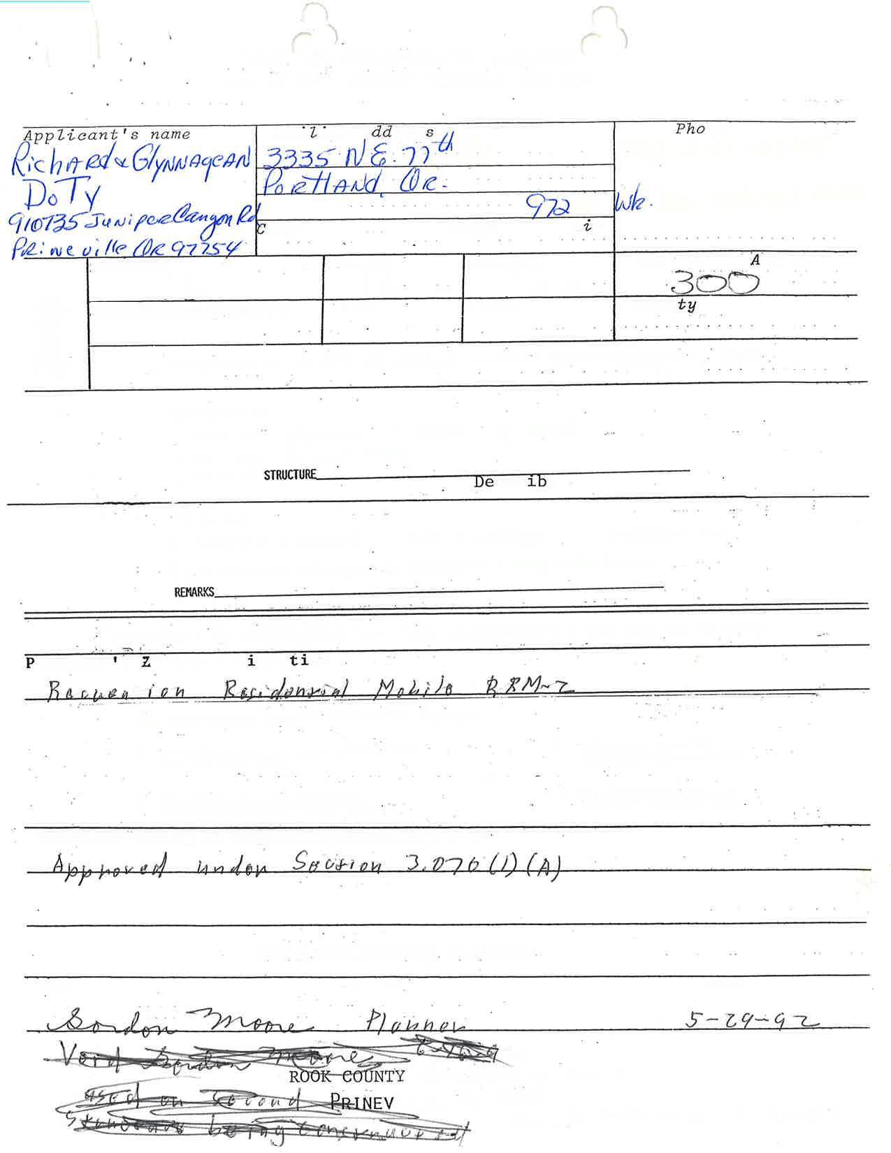
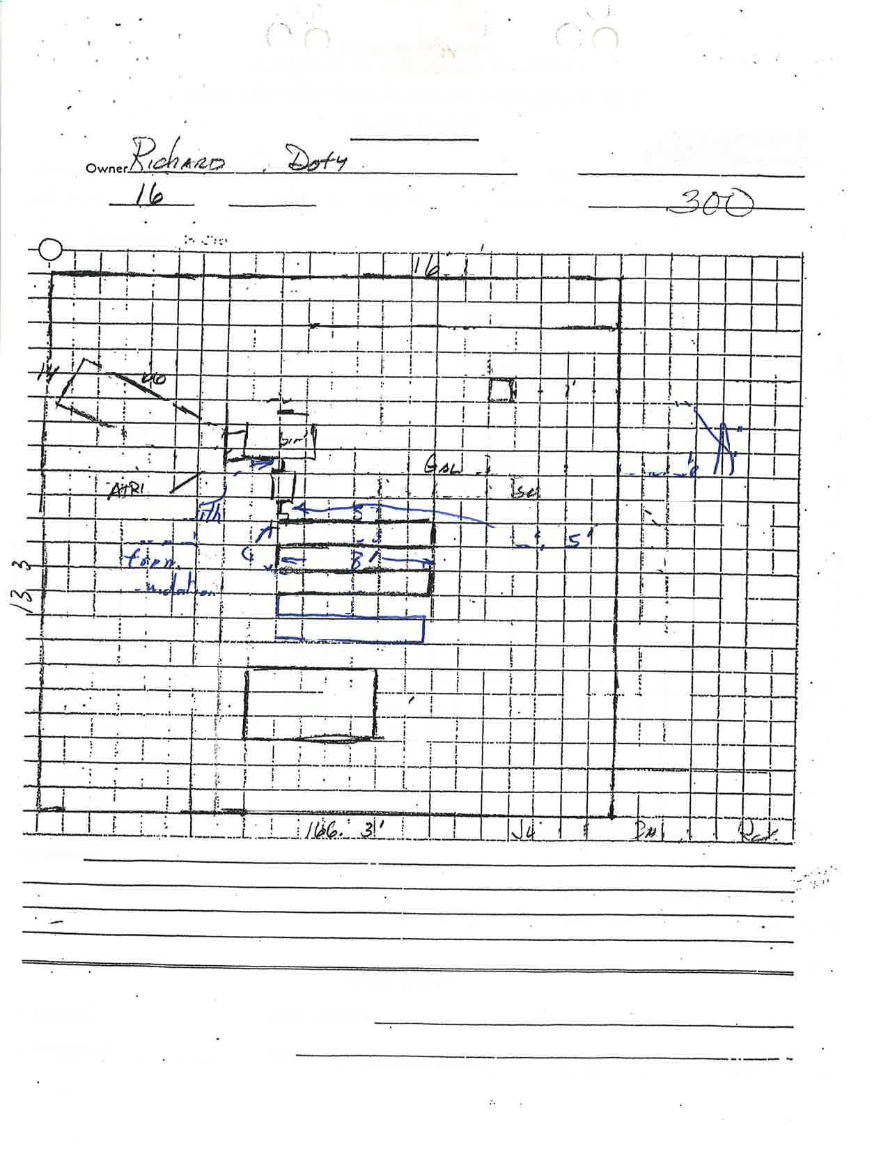
CROOK COI'NTY
BEFORE THE PI.A}INING COMMISSION
IN THE }IATTER OF AI{ APPLICATTON NO. FOR PARTITTONING AI{D VARIA}ICE IN A RECREATION RESIDENTIAI MOBILE ZONE RRM-s
SUMT{ARY:
c-LP-176-99, c-v-91-99
FINAI DECISION
APPLICANT : Crook County Rura.l- Fire Protection District No. 1
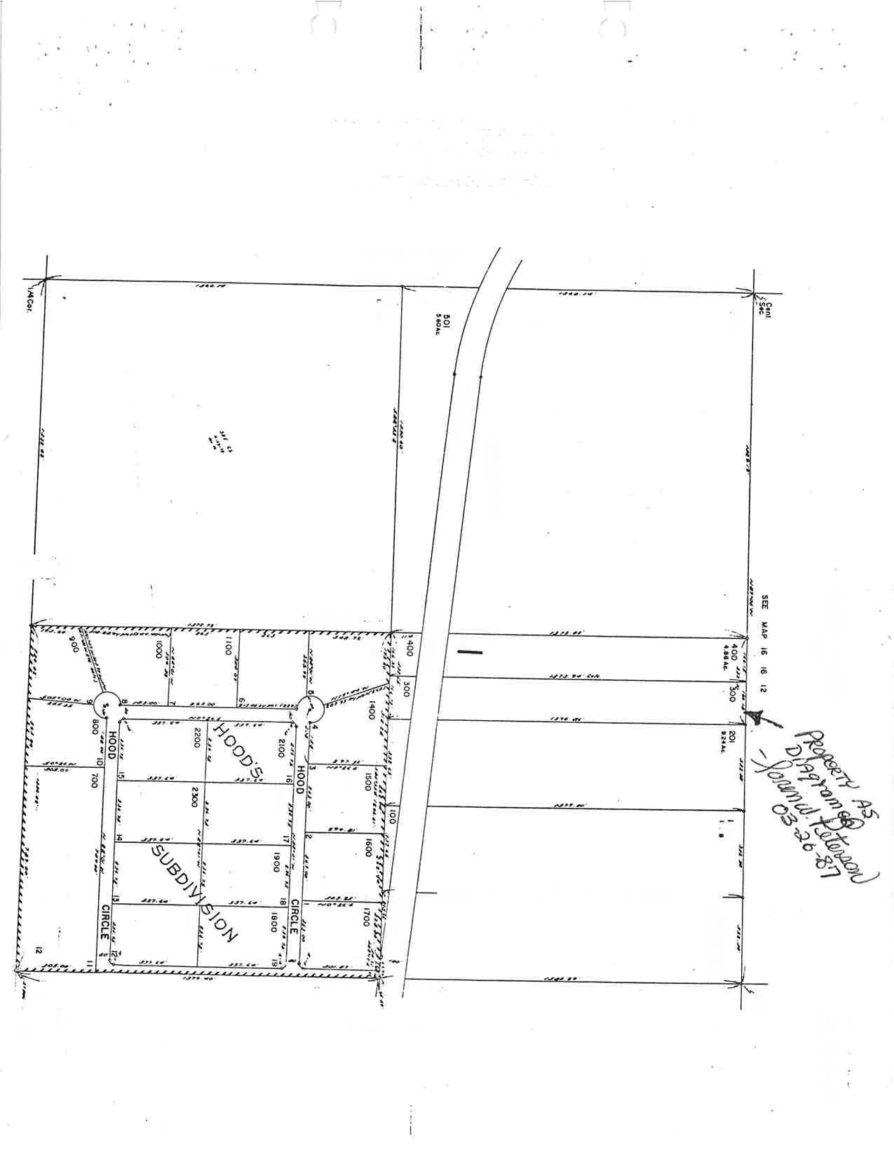
TAX LOT NO.: T 16 S R 1,6 EWM Sec !2 D TL 300, 400
REQUEST: A partitioning to divide a 9.13 acre parcel to two parcels of 1.00 acre and 8.73 acres, and a variance 5.00 acre mlnimum size for a new parcel in a Recreation Residential Mobil-e zone RRM-5.
F]NAL DEC]SION: APPROVED AS REQUESTED
APPRO\IED SUBiIECT TO CONDITIONS x DENIED
NONFARM PARCEL,. TAKE OFE FARM DEFERRAL PARCELS
create from the
CONDITIONS: (1) A final plat is to be submitted wj-thin six months in accordance with Section 5.060 of the Crook County Land Development Ordinance
(2) A11 taxes, fees, and assessments must under ORS 92.095 before the final- plat j-s be paid as required f il-ed.
setbacks for the RRM-5 zone are to be (3) The adhered
(4) any lega11y required to.
The necessary fand use approvals are to be obtained prior to construction.
DATE OF FINAL DECISION: October 13, 1999
E'ILING DEADLINE FOR STBMISSION OF APPEAL: October 25, 1,999
Crook County Rural Fire Protection District No. 1, Decision c-LP-176-99, C-V-91-99
Page 2
THE ABO\IE ENTITLED LIATIER came before the Planning Commission at its regular meetings of and September 22, 1999.
LEGAI CRITERIA
Crook County August 11, 1999,
@Th"propertyj-szonedRecreationResidentia1Mobi1eRRM-
5. Section 3.070 of the Crook County Zoning Ordj-nance contains requirements for this zone. Publ-ic uses and buil-dings necessary to serve the recreation residentlal needs of the area are permitted outright under Section 3.070 (1) (E).
Under Section 3.070 (9) the RRM-5 zone is 5 acres.
minimum size for new parcels in the
Article 7 contains requirements for variances. Under Section 7.020, a variance may be granted only if al-l- of the following circumstances exlst:
( 1 ) Exceptional or extraordinary circumstances apply to the property which do not apply generalJ-y to other properties in the same zone or vicinity, and result from l-ot size or shape, topography, or other circumstances over which the owners of the property sj-nce enactment of the Zoning Ordj-nance have had no control-.
(2) The variance is necessary for preservation of property right of the applicant substantially the as owners of other properties in the same zone or possess. a same vlcinity
(3) The variance would not be materially detrj-mental to the purposes of the Zoning Ordinance, or to property in the same zone or vicinity r or otherwise conflict with the objectives of any County plan or policy.
(4) The variance requested is the minimum variance which would alleviate the hardship.
LAI{D DEVELOPMENT ORDINANCE : Section contains Land Development Ordinance partitionings.
5.030 of the Crook County general requirements for
Section 5.030 of the Land Development
No application for partitioning shall-
Ordlnance states that: be approved unl-ess the
Crook County Rural Fire Protection District No. 1 c-LP-176-99, C-V-91-99
Page 3
following requirements are met: USES.
Decision
(1) Proposal is in compliance with the Comprehensj-ve P1an.
(2\ Proposal is in complJ-ance with the applj-cable zoning.
(3) Each parcel is suited for the use intended or offered.
(4) Proposal is compatible with adjoining and area land
(s ) Alr_ available and peti-tioner. required pubJ-ic services and facil-ities are adequate, or are proposed to be provided by the
(6) Proposal will not have any adverse impacts on adjoining or area land uses, public services and facilities, and natural resource carrying capacities.
(7) An approved water rights division plan has been submitted. (This provision is not reLevant to the present appfications because the property has no water rights)
COMPREHENSIVE PLAI{I : Pages 54-60 of the Crook County Prinevil-le Area Comprehensj-ve Pl-an contain requirements for Recreation areas of the County.
FACTS
BACKGROTIND: The Planning Commission granted conditional use approval for an 1800 square foot personal use boat storage/workshop structure on the property on September 18, 1990 (C-CU-549-90) . The structure has been constructed.
ACREAGE: The property measures 9.13 acres. The proposed parcels are to measure 1.00 acre and 8.73 acres.
CURRENT USE OF THE PROPERTY: Two residences, a storage/workshop located on the proposed 8.73 acre structure, and outbuildings are parcel. The proposed 1.00 acre parcel is vacant.
AREA LAIID USE: A11 lands in the area of the property are zoned Recreation Residential MobiIe RRM-5. The property is directly to the north of Hood's Subdivision, a residential subdivision consisting of approximately 2.00 acre l-ots. Several 1,0-20 acre
Crook County c-LP-176-99, Page 4
Rural Fire Protection District No. 1 c-v-91-99
Decision ,
residential- parcels are l-ocated Larger (20-40 acre) parcels are southwest of the property.
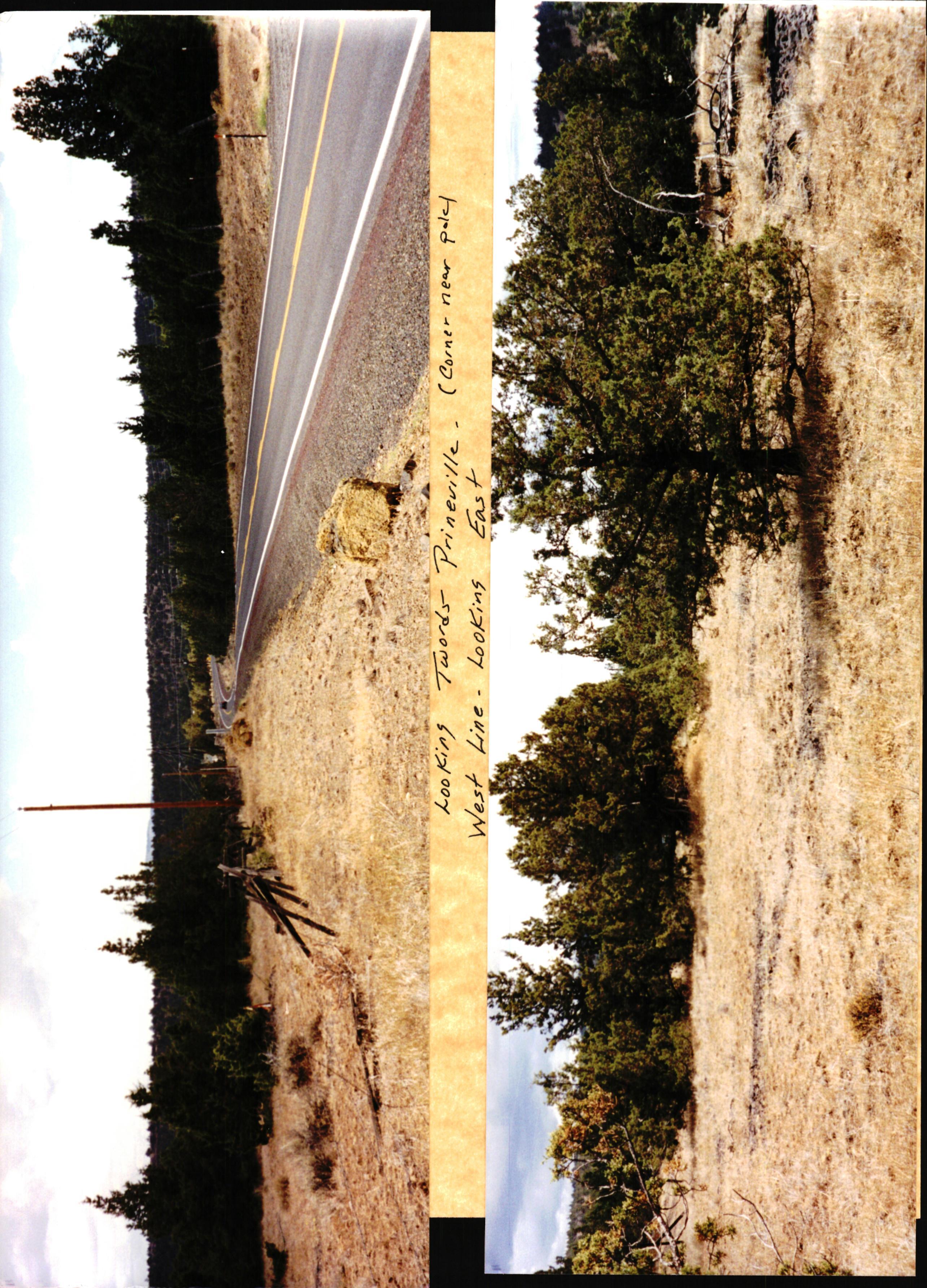
ACCESS: The an existing of Juniper to the east of located to the the property.north, west, and
property is adjacent to Juniper driveway the proposed 8.73 acre Canyon Road. Canyon parcel Road. There is to the north
FARM DEFERRAI: ThC property is not under farm deferraf
IRRIGATION: The property is not irrigated and has no water rights
FLOOD ZONE: The property is in Elood Zone X outside the 500 year flood zone.
WETLAIID: The property is not in a designated wetland area.
UTILITIES: Electricity and telephone service are availabl-e to the property.
WATER: Water is provided by wells on the property.
SEPTIC: There i-s acre parcel. The an existing septic proposed one acre parcel T system on the proposed 8.73 parcel is to be served by a 76 S R L6 EWM Sec 1,2 D TL 501. septic system on adjacent
SETBACKS: .""r *if-1
Setbacks of 20 feet front, 10 feet side, and 20 feet be required for al-1 existing and proposed structures.
TESTIMONY: Three persons testified in support of the proposal.
One stated that the property is within five miles of most of the Juniper Canyon area. He said that four volunteer firefighters live within two mil-es of the property. He sald that the property is the best location for the proposed fire statj-on. He said that provision of fire protection j-n the Juniper Canyon area is critical-, and that the station wil-l- provide backup fire protection for Prineville and Powell- Butte. He said that the property is being donated, and gettlng property for free is an important consideration for the Fire District.
He sald that the proposed station will have 3-4 equipment bays and crew quarters. He said that the site has been approved for a septic system and is large enough for the proposed fire station.
Crook County c-LP-17 6-99 , Page 5
He said tankers tankers
Rura]- Fire Protection District No. 1 c-v-91-99
that a well- on the property to provide is proposed, and that additional water f rom Prinevil]e.
Decision water to fill can be carried by
The Prinevj-l-Ie fire chief testified that the property i-s a good location for the proposed station. He said that the station wil-lbe a good use of the property and will serve the area well.
Another person Fire Board and testified that she is a member of the Powell Butte that they are in favor of the proposal.
Another person said that favor of the proposal. he lives near the property and is in There was no opposj-tion or bipartisan testimony. coNcLusroNs
( 1 ) Exceptional and extraordinary circumstances apply to the propertyr ds the record and testimony received indicate that the property is the most suitable location for a fire station for the Juniper Canyon area and is being offered to the Fire District free of charge.
(2) The proposed varj-ance is necessary to preserve a property right of the applicant, as the record and testimony received indicate that it is necessary to permit a fire station to be built in a suitable .l-ocatj-on without excessive cost, and that provision of a fire statj-on in the Juniper Canyon area is of crit j-cal importance.
(3) The record and testimony received indicate that the variance would not be materially detrimental to the purposes of the Zoning Ordinance, or to property 1n the same zone or vicinity, or otherwlse conflj-ct with the objectives of any County plan or poJ-icy.
(4) The variance reguested is the minimum variance which would alleviate the hardship, ds it is necessary to permit a fire station to be buil-t in a suitab]e l-ocation wi-thout excessi-ve cost.
(5) The record and testimony received indicate that is in compliance with the Comprehensive Pl-an and the zoning.
the proposal applicable
Crook County c-LP-17 6-99 , Page 6
Rural Fire Protection District No. 1 c-v-91-99
Decision
(6) The record and testimony received indicate that the proposed parcels are suited for the uses intended.
(7) The record and is compatible with testimony adj oining received and area indicate that the proposal land uses.
( B ) The record and testlmony recej-ved indicate that all required public servj-ces and f acil-ities are available and adequate.
DECISION
Approval is granted subject to the following CONDITIONS and REQUIREMENTS:
(1) A final- plat is to be submitted within accordance with Secti-on 5.060 of the Crook Development Ordinance.
six months in County Land
(2) A11 taxes, fees, and assessments must under ORS 92.095 before the final- plat is be paid as required filed.
(3) The adhered 1ega1Iy required to. setbacks for the RRM-5 zone are to be
(4) any The necessary land construction. use approvals are to tained prior to CHET P T EN, COMMISSI CHAIRMAN .-2^--l^'*
GORDON MOORE, AICP COMM]SS]ON SECRETARY
NOTICE TO APPLICAIVT
A final plat is to be fil-ed no later unless an extension has been appJ-ied than April L3, 20OO, for prior to that date.
a7*
d L \ \ c 0) E c, U -( \ o, 0< RI $ $r .flt ; Jd \ \ \ \ $ o h d IJ \ \ \ ( u ,f \, -$ )'r $.6),0o .\+S fu,'Fr lnt , rsr* x: 2g ft s \ \ \ ,l \ v rL T ) tr \ $ u h N N \ t \J .\ ni [\ lo N
ieot ra,l q Qt )
il * t\ N
$\ \
S \ \)
o ,v v
I
+,
et t ]r \ Ll
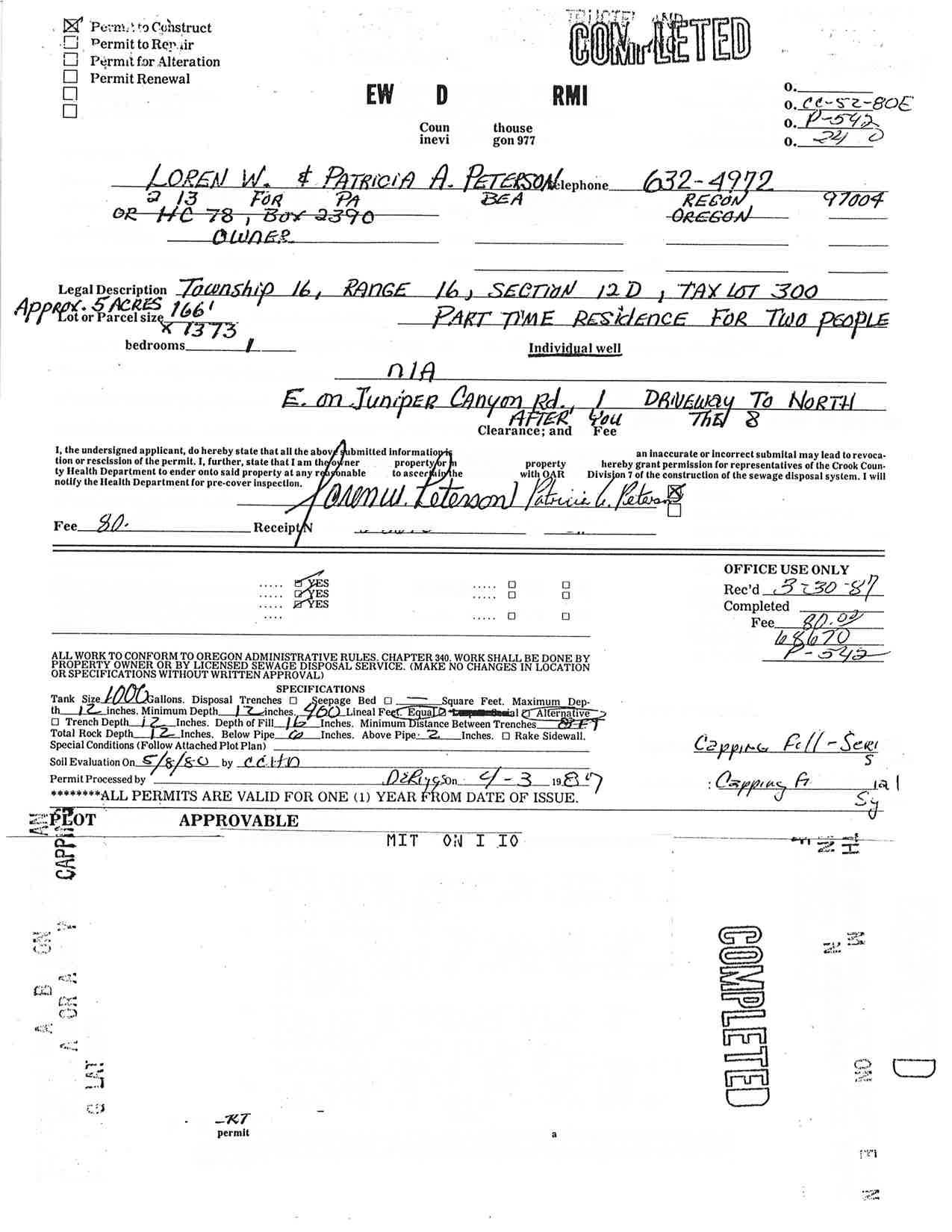
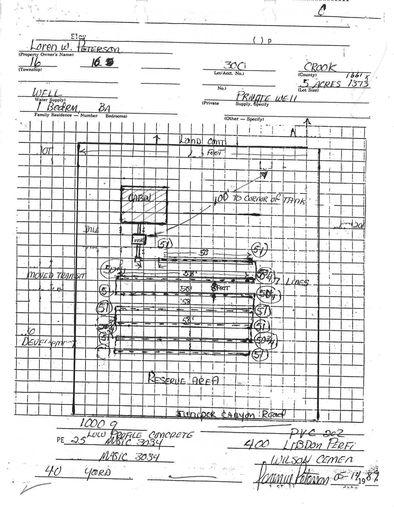
ENVIRONMENTAL HEAIJTH
SEPTEMBER I3, 1999
300 E 3rd Street . prineville, Oregon g7754
Phone (s4L) 447-81ss . EAX (s4tf 447_10s1
CROOK COUNTY RURAL FIRE PROTECTION DIST., #I
5OO N. BELKNAP
PRINEVILLE, OR 97754
Dear Crooli Cou:ity Rural Fire protection Dist., #1, RE: SITE EVALUATION
075-182-gg
t6-t6-t2 TL 300 & 400
I ACRE +
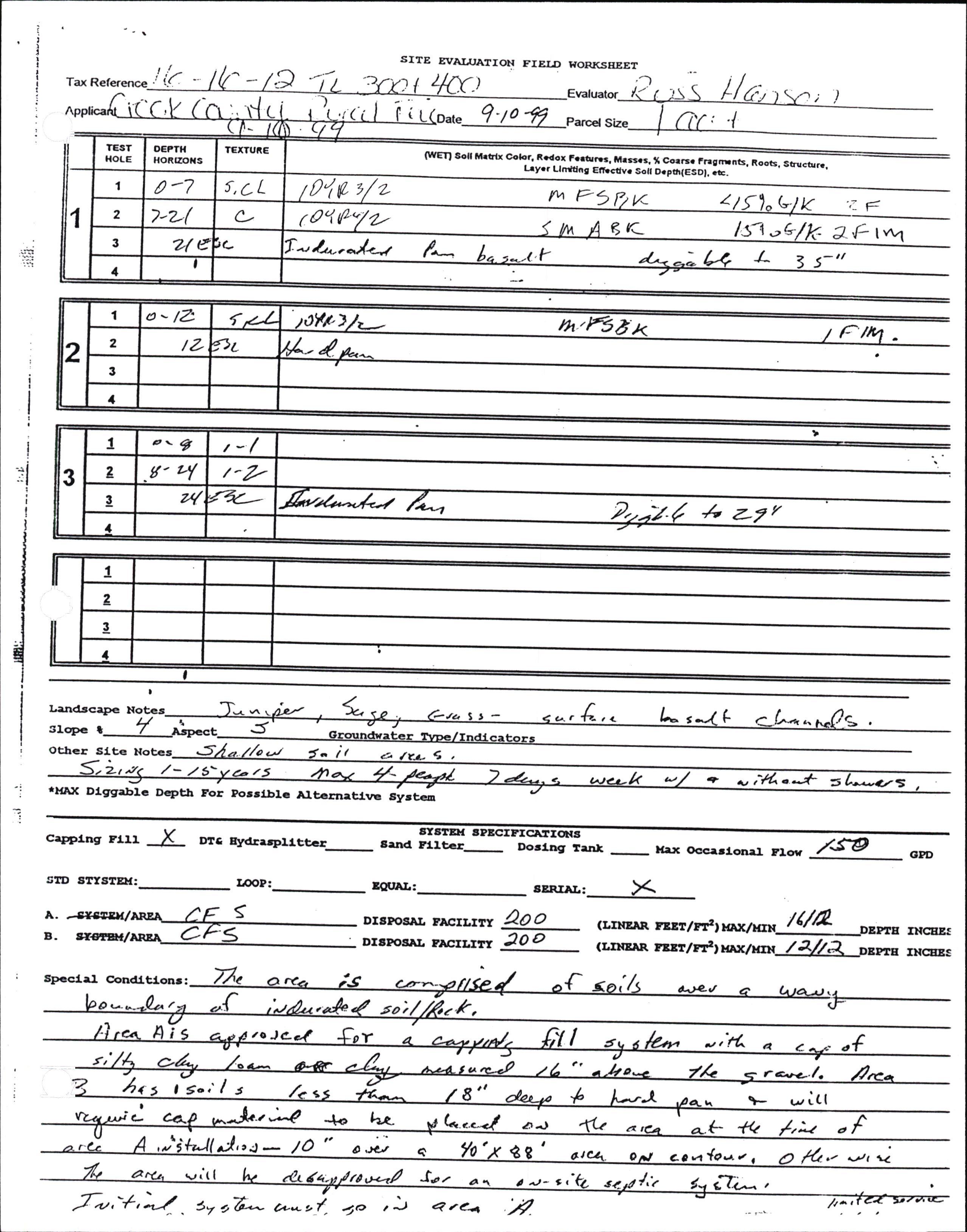
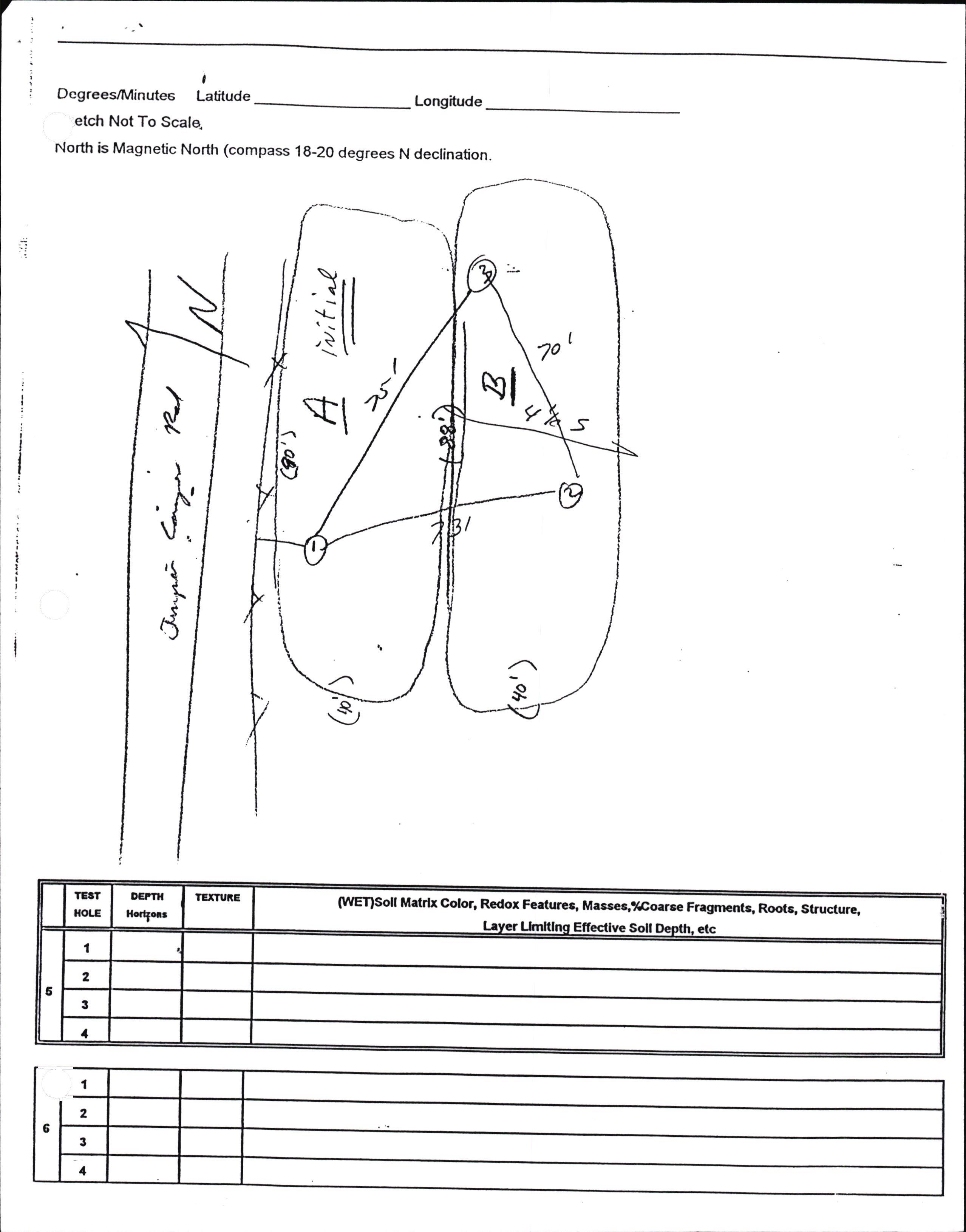
Based on the soil profile in the test holes you provided, the site is approved for an on-site sewage disposal system to serve a 4 person fire station, with kiichen and shtwer. A copy of the Site Evaluation Field worksheet is attached and the system requirements are:
- The site is approved for a capping fill serial on-site system with an average flow of 200 gallons per day.
- 100 lineal feet of drain field line per person of flow for a total of 200 linear feet of drain field line.
- Maximum trench depth is i6", minimum is 12,,.
- The area is comprised of soils over a wavy boundary of indurated soiUrock.
- Area "A" isapproved for a capping fill system with a cap of silty clay loam or clay measured 16,, above the gravel
- Area "B" has soils less than 18" deep to hard pan and will require cap material to be placed on the area at the time of area "A'installation,l0,, over a 40, x gg, area on contour' otherwise this approvalvill be disapproved for an on-site r.fi" system.
- Initial system must go in area..A".
The State of Oregon does not allow capping fill drain fields to be installed after Oct. I'r to June lo without prior approval. Wct or frozen soils will prevent this office from approving capping fills during that time period.
Cover top ofgravel with drain field paper.
Approved area must be protected from buildings or driveway installation.
Install initial and replacement in area
Do not work the soil or install drain soil is wet
Install lines across contour, level end tb ehdir;l
Trench width is24,.. .-J
Install with drop boxes.
Submit a constuction plot with elevations.
Drain field set backs: l0 00 any well.
DRAIN FIELD MUST conditions
f k a D e o ent
++
(i.e. :'P*i9P* *
the natural or the subject or adjacent properties may void this approval (ORS 454'and
of
Crook County Rural Fire Protection Dist., #l Page2
DRAIN FIELD MUST BE INSTALLED
Any alteration of the natural
conditions (i.e. cutting or filling) in the approval area, or further partitioning or subdividing on the subject or adjacent propities may void this approval (ORS 454 and, oAR 340).
- The proposed areas for both initial and replacement systerns are to be protected from vehicular toaffrc, livestock or further development.
- Specifications for the replacement system should the initial system fail are noted on the site evaluation worksheet. Specifications for this system may differ from those for the initial system. The area noted for the repair system is to be kept free from any futgre development or activities that would alter the site conditions.
- The use of the infiltrator (equalizer) drain field system shall be proposed at the time of the septic construction permit application.
- If you use the infiltrator in irrigated land, you will need to contact the manufacturer to see what they require to prevent gopher intrusion in to the interior space at l-t00-2214436.
- Recommend a septic tank with an effluent filter if you are going to have a garbage disposal.
- Infiltrator systems will require observation ports.
Any person other than the property owner must be licensed by the DEQ to install an on-site sewage disposal system. In additibn, a PERMIT must be obtained from this office prior to installation of the system. The following items must be submitted along with a "ornpl.t.d "rrd signed construction permit application form( the necessary forms are en-closed):
LOCATION'S MARKED ON TIIE PLAN.
A LAND USE COMPATIBILITY STATEMENT SIGIYED BY THE CROOK COT]NTY PLANMNG DEPARTMENT.
A PERTVTIT FEE OF'$580.00.IYILL BE CHARGED FOR THE CAPPING FILL SYSTEM.
Ifyou have any questions regarding this report or permit procedures, please feel free to contact this office at (541) 447-BLSS.
Sincerely,
F. HANSON, R.S. Director
,t /.rE. ,.\-^^1, /a^-..-r-. Ytt-.---
,f
ju
(2)
Encl.
tir
Tax .-" I /- -) ;)
-1o -t
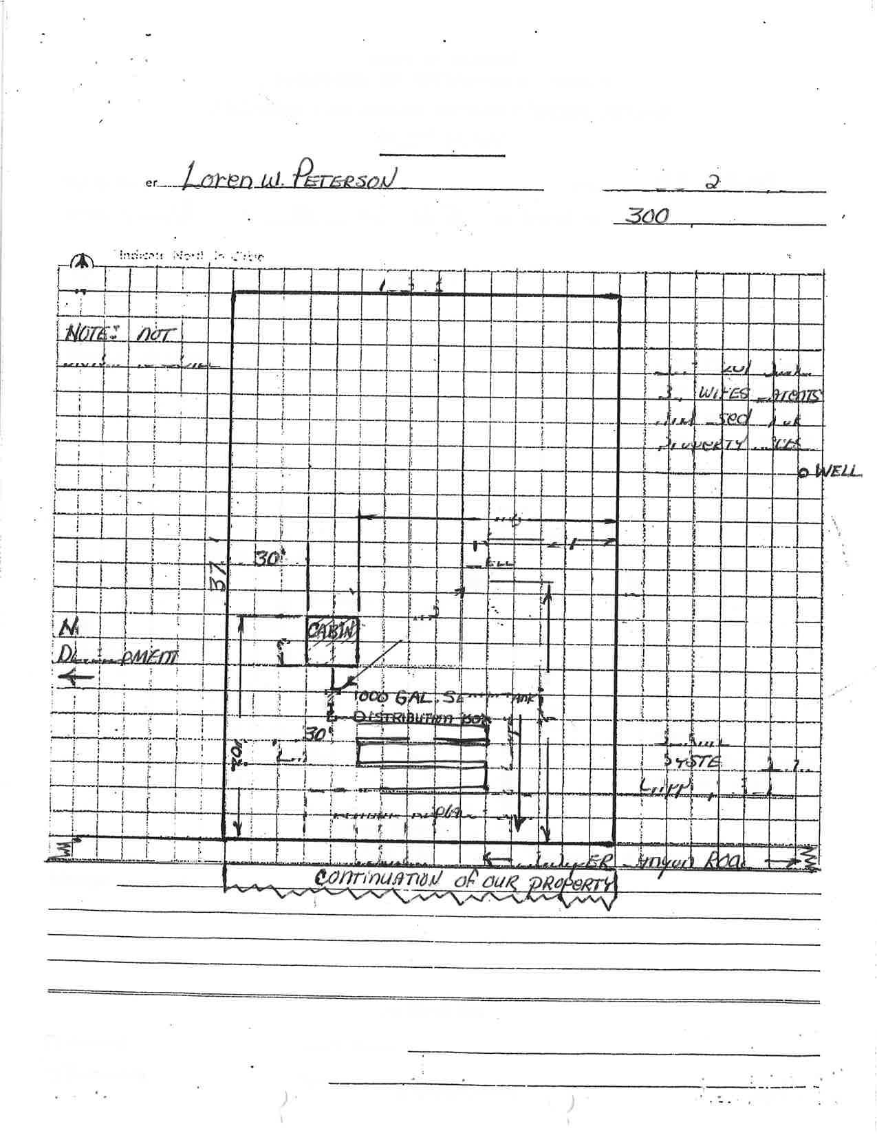
(WETI Solt Mr6x Coloi. i.{ox l.rtmr, Mrs.r. ,( Co.E. lEgrnts. lloots, Stcctrr.. Lry.r Llfiidot Erl.cdy. Solt D.prr!(ESOr, .tc// fu 7t K /. C., l< '.€
(o'l ?/ l(_ l.s-t o J-G tvn ln..a(-l /^- ? L 5- tl ) /J1.2 /: )
.A
-4 Z-7 r E
La.trd.scal,e Z*, ,{- L r
Slol- 5
Other SI.te t
rXAX D1gtlIabl.c Dclrth For porrtb].. Alt rnatl'vr ayrtca
...* = 5
calD,.ngl rrf.f X rxrc Eydn lrl1ttcr gfEtE{ aand Fut'r- Dollng'rer*xer( occ,lon:l Elor /.s@ GPD
sII) STTSTEH: tpoD:_ IOUAL: AER!AL: )(
A. B.
DrsposAL pAcrr.rrr 2o o
Drl,osrL pAcrLrrr 2o o : st,GcJ.a:. CondlCJ'on,
(LrNErR ,rrwtsi:troo<t$N /m-DEpra rNcBEs (LrNErR r:8r/rt', Har( trg;tt-/ el A_oEprE rNcEBs
SITE
S1IALUATION PIEII) WORK.SFPET
C
,o )c I ur'il "{ a .ft I l-g-i I s J a C$- * itt ,4 -tp hl- /J 4) (- +<< .f I o " o're, lo rrJe .- ,Jt a< a .'t t ^t- t. TEST HOLE O€PTH HOREOT{S TEXTURE
0-7
101p 1/ 2 )-z( (r 3 ae 'L 1 1 I 1 o' lz {// 2 /Z
3 2 1 1 o'q Z .s- t-{ /-? E z{. ,{z_- 3 1 L ? !, 1 J--,Y,i . Jy.rd* a-*r/. 4o ,i e.?a ," a oq{ou. i ,I , i I I I I : : : (
'0t
1
f,CL
17t
, Degrees/Minutes Latitude
etch Not To Scalq Longitude
North is Magnetic North (compass 1g-20 degrees N decrination.
-i \ ,\ ?0 )\. t _s } s rI I d 1 2 6 TEST NOLE OE?III Hortc.. TETTUiC Color, Redor Feltureq Massee,l(Coerse Fr.grncnts, R@ta, Structurc, Effectlve etc (MlETlSoll Matrlx 1 2 3 5 3 1 I j I t , I : i i I a ! I I ; I I
\
STAE.F REPORT
DATE July 29, 1-999
APPLICATION NO. : C-LP-L'1 6-99; C-V-97-99
APPLICA}IT: Crook County Rural- Fire Protectj-on District No. 1 c/o Prinevil-Ie Eire Department 500 N BelknapPrinevi.lle OR 97754
PROPERTY tOGLTION: On to the east of Davis
both sides of Road (T L6 S R
Juniper Canyon Road 0.25 mil-e 16 EWM Sec 72 D TL 300, 400)
PROPOSAL: A partitioning to divide a 9.73 acre parcel to create two parcels of l-.00 acre and 8.73 acres, and for a variance from the 5.00 acre minimum size for a new parcel in a Recreation Residential Mobile zone RRM-5.
APPLICATION DATE: July 12, L999
PUBLIC NOTICE: July 22, 1999
PROPERTY OWNER NOTICE: July 16, 1,999
HEARING DATE: August Lt., l-999
FACTS
BACKGROT]ND: The Planning Commission granted conditional use approval for an 1800 square foot personal use boat storage/workshop structure on the property on September 18, 1990 (C-CU-549-90). The structure has been constructed.
ACREAGE: The property measures 9 73 acres. The acres. proposed parcels
are to measure 1.00 acre and 8.73
CITRRENT USE OE THE PROPERTY: Two structure, and outbuildings are parcel. The proposed 1.00 acre
residences, a storage/workshop located on the proposed 8.73 acre parcel is vacant.
AREA I,A}ID USE: AIl lands in the area of the property are zoned Recreation Residential Mobile RRM-5. The property is directly to the north of Hood's Subdivisi-on, a residential subdivj-sion consisting of approximately 2.00 acre lots. Several t0-20 acre residential parcels are located to the east of the property. Larger (20-40 acre) parcels are located to the north, west, and southwest of the property.
Crook County c-LP-176-99, Page 2
ACCESS: The an existing of Juniper
Rural Fire Protection District No. 1 c-v-91-99
property is adjacent to Juniper driveway the proposed 8.73 acre Canyon Road.
Canyon parcel Road. There is to the north
FARM DEFERRAI: The property is not under farm deferral-.
fRRIGATION: The property is not irrigated and has no water rights.
FLOOD ZO
required public services and facilities are adequate, or are proposed to be provided by the
(6) Proposal wj-II not have any adverse impacts on adjoining or area land uses, public services and facilities, and natural resource carrying capacities.
(7) An approved water rights division plan has been submitted. lThis provision js not reTevant to the present appTications because the property has no water rights)
Crook County Rural Fire Protection District No. 1 c-LP-176-99, C-V-91-99
Page 4
COMPREHENSI\IE PI.A}iI : Pages 54-60 Plan contain of the Crook requirements County PrineviLle for Recreation areas Area Comprehensive of the County.
AIIALYSIS
The Rural Eire Protection District proposes to place a fire station on the proposed one acre parcel. This use is permitted outri-ght under Section 3.070 (1) (E) of the Crook County Zoning Ordinance. They are requesting a variance from the mj-ni-mum parcel size of 5 acres in the RRM-S zone.
The Commj-ssion might consj-der whether the application meets the requirements for a variance.
Assistant P1annj-ng Director
9- c "--,O+-,-lLr-- /h--n_n-t
Affiidltt sf lpuhliffttrrr
STATE OF ORE@N, couNTY oF cRoorc ) ) )
t,Jm F. Schaffet' .bci!86'"tduly ryom, dcposc ead s1l tbet I.E th! orler, Aitor, 1nb lisicr. _4!4t8, e!aq{ !!g Erlrger, riacipd A.rt o( tie CEMIBAL OREGONITN. DriBscr or his-loremea of thc CElllfRAL OBEGONIAN, e Ecrsprpcr ol gaa- el circuhtios, as dGdEGd tt OBS UB-010-aEd fS.OA0: priltcd eld gublishcd rt Princvitre, i! thc abreseid
corrrE etrd st tt; e printad cogy ol thrt thr not ice rnicn ir hcrcto .racre4 ses fblisb ed in thc catirc issnr d lrid Ecrsprpcr lor -g-E.9- successivc ad csarccutivc rccks iE tlc lolloring isrucs
Issue dt tD JuIy 22 , 19 9I
Issuc
Issuc Aqlc
Issue Azto
Issue
C.LP. Rerch a24!
Paral
Choot
SEAL KLUDT
ltc fec chrrgcd (br thc abovc gttllcldoa rrr
2
Gen Mgr
Subrcribcd esd sg'o1a !o bc6re 6q rhk 3 0 t h
dzy JuI r, 99
NotrtT {br
l(y Coomissioo 9-17-01 rfclr
8u
W ..n *i c. "fi, ti t', I ! I , t I ) a 0I qr t I s a U I I rl T\ \l -: NI r, \.\ ,\'\ \o\St^\ \\i s ,: \l $* L) !l c i!r N '' / 'mtp .(- 't .' l, | ' s' 'a ,.,. ,a'. I I I I .i , I a I , I ) # ?r'' t. Et ,,1r. a\ I I 1". ,l , I :ti t t rff ri a F' T t ri!r\ '?', ' I I 5 ,| '{ ,t { { s,\ I - 't a Y; t
A a , t \ I $ c, qo tL + q \ \( * ( q \s \ \ 1 I ; .\ \ J+ s o vl t I tt" ., J l, n t ,1. !r.'t ,i
t ,. l, ,. ,F at l.;' ..rt I 1," I H -?,-1, L:, ) v it , 7 1 I -ral-Il 1 ti I I J frI;l t , \( $t a-: d! \) +^i ,s \k b,.J '{ q\ U VN o' c ..-t \o I t t I Itrt\ .J t .r I r r ( s \\ d -[d ,\ .\ SQ e'3 r{x fi I I. a -{ '( I ) r: I rl i I I I :1 't It \ \ \ r .-I J,f u \5 J : ; I a e! -1
a: V :l f II t N \ -Pq N\ \ \ \ ( .t \ \.l tt l, ..-\N .\T\\ ra\ \ 'jQ ** $ \ \, \Ot .i. a l \ s .t tl I T I IT I I f a EI itJ d, .fr ,l t t t $ 1 \ I .J IrI t m U\; '., Q ,t. {i, \ ,.ul# W. ':' il ; .a / ,YEl* . ';ir*1f';.i r # I h, I l,'I a a s ,f I \ .t { ,.: t I E-:, \ \ t f.t-t*r., h,' Ls'ri w. ( il.' ,.J\ f], i: , tu tr t'{t "it .t I :-! I J YT-T ! lr,
l]\ .s' J \v .)i \ tt (\F\ t* \{_ -sn <t s a\ .i' \. a s \ I .t} J aa
I i * tL ,ir: # at f Y $l$ \t P\ rN .a {. sn s ,\ \{ \r Ss \\ t-l t\ $\ .\ .\ n -lr I E JA T I ) / \\ *d .v T a . a ! I I -a. I t 't l','.,-"' {f r{I I I l', -. l.{ ? rrr q J I I i! ( i. F { 1''i 4 I I I! I t ,.L a iq ! !
i a qI --', { tlr \ lt [, r; ,T Y t t F t.. I rt rI fl J .I 7 d 't I i'. , I rl
fr l'' a I 6-.,.. o 1) / ,at r&r { t q
I I I I I 7 [J i. , I I d - I ,! l' TE ffi ,rl J f I q I ,A , I t

I t i 7 \\ rl r'1 ! r a t:
, ..: ill'i 't* IS;l--1 /uE3 I I I I , .,
l,: li ri' t, is I -fi E rj \' I I lr I ]1 aI t \ t t-r
AFFIDAVIT OF MAILING
ss.
I, Vickie S. Smith, being first duly sworn, depose and say t.hat I am the person responsible for depositing all decisions that are required pursuanL to Chapters 197 and 21-5 of the Oregon Revised Statutes (1991) to be mailed by the County of Crook; that the mailed decision was deposited on Oct.ober a4, 1,999 in the United States mai1, proper postage affixed thereon, to the following persons, entities, addresses and on the dates bel-ow described.
Applicant: Application No.
Crook Countv Rural Fire Protection District No. 1
c-LP-]-76-99 & C-V-9]--99
Jurisdiction: Crook Count-w
Person/Entity and address:
Crook Count.y Rural Fire Protection District. #f 500 N. BelknapPrineville, OR 97754
Mr. & Mrs. Walter H. Hines
t1-902 SE Slo Goin Rd. Prineville, OR 97754
Jon ,finnings DLCD
Empire Corporate Park, 203L0 Empire Avenue Bend, OR 9770L
Ron Eber 1175 NE Court Street
Sa1em, OR 973L0
Brian Ferry ODFW 2042 SW Paulina Hwy. Prineville, OR 9'7154
Bill Zelenka PO Box 25
Prineville, OR 97754 Suite B-1
County Assessor
Crook County Courthouse 3OO NE 3'd Street
Prineville, OR 97754
1 2 3 4 5 6 7 8 9 10 11 L2 13 L4 t-5 t6 L7 18 19 20 21, 22 23 24 25 25 27 28
County
STATE OF OREGON,
of Crook

Notary Public for Oregon
My commission expires: /_d_a3
Dave ArmstrongArmstrong Surveying 379 E 2nd Prineville, OR 97754 1 2 3 4 5 6 7 8 9 t_0 11 l2 13 1,4 15 l_5 t7 18 19 ZU 21, 22 23 24 25 26 27 28 Vickie S. Smith , Secretary Subscribed and sworn to before me this 14th day of October, L999.
NoTARYPUBLIc-oREGoN
No 318050 MY COMMISSION EXPIRES JAN. 5, 2OO3
ffi "3,'Jl"#,1[fti" \{tgl,
\rw/ coMMtsstoN
t/ n h/d/ A 7-,?/-7'f '1 t h*r<-ro4- Zax>"t, i -r.rc //>1 4/' /u< arL-+-\ 91rt.n flLc- l/UA" ,/ /b Auvv-*l a-///v-,a 7r &4 /9 t*/4*--. &. f llts i tri Ir -h JUL 2 0 lgss Lr..futrtnrtrrl uErt. ***
Crook County Rura1 Fire Protection Digtrict No. 1
c-LP-L7 6 -99, C-V-91-99
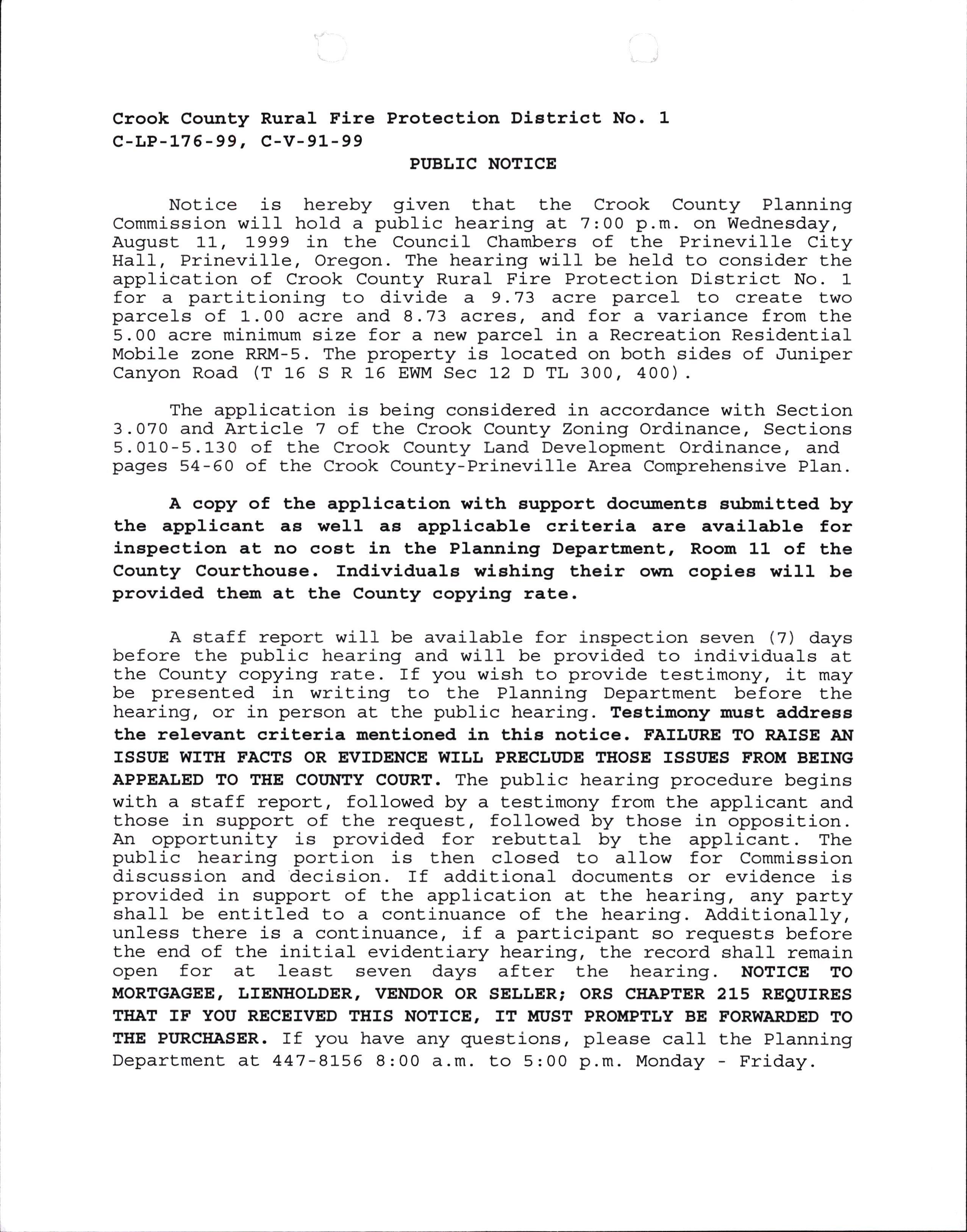
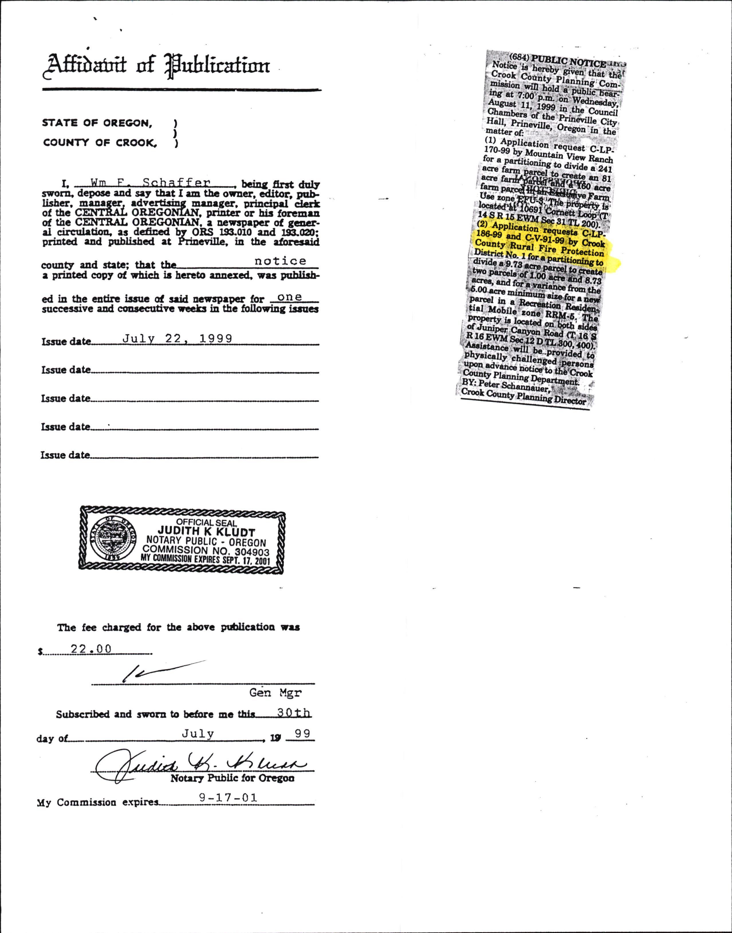
PI'BLIC NOTICE
Notice is hereby given that the Crook County Planning Commission will hold a public hearing at. 7:00 p.m. on Wednesday, August 11, 1999 in the Council Chambers of t.he Prineville City HaI1, Prineville, Oregon. The hearing will be held to consider the application of Crook County Rural Fire Protection District. No. 1 for a partitioning to divide a 9.73 acre parcel to create two parcels of 1.00 acre and 8.13 acres, and for a variance from the 5.00 acre minimum size for a new parcel in a Recreation Resident,ial Mobile zor:.e RRM-5. The property is located on both sides of .funiper Canyon Road (t 15 S R l-5 EWM Sec 12 D TL 300, 400)
The application is being considered in accordance with Section 3.070 and Article 7 of the Crook County Zoning Ordinance, Sections 5.010-5.130 of the Crook County Land Development Ordinance, and pages 54-50 of the Crook County-Prineville Area Comprehensive Plan.
A copy of the application with eupport docunents submitted by the applicant aE weJ.l a6 applicable criteria are available for inepection at no cost in the Planning Department, Room 11 of the County Courthouee. IndividualE wishing their ourn copiea will be provided them at the County copying rate.
A staff report will be available for inspection seven (7) days before the public hearing and will be provided to individuals at the County copying rate. If you wj-sh to provide test.imony, it may be presented in writing to the Planning Depart.ment before the hearing, or in person at the public hearing. Testimony must address the relevant criteria mentioned in this notice. FAILITRE TO RAISE AI{ ISSI'E WITH FACTS OR EVIDENCE WII,L PRECI,I'DE THOSE ISSI'ES FROM BEING APPEALED TO THE COIrlfltY COURT. The public hearing procedure begins with a staff report., followed by a testimony from the applicant and t.hose in support of the request, followed by those in opposition. An opportunity is provided for rebuttal by the applicant. The public hearing portion is then closed to al1ow for Commission discussion and decision. If additional documents or evidence is provided in support of the application at the hearing, dtry party shall be entitled to a continuance of the hearing. Additionally, unless there is a cont.j-nuance, if a participant so requests before the end of the initial evidentiary hearing, the record sha1I remain open for at least seven days after the hearj-ng. NOTICE TO MORTGAGEE, LIENHOIJDER, VENDOR OR SELLER; ORS CIIAPTER 215 REQUIRES THAT IF YOU RECEIVED THIS NOTICE, IT MUST PROMPTLY BE FORWARDED TO THE PITRCHASER. If you have any quest.ions, please ca11 the Planning Department at 447-8155 B:00 a.m. to 5:00 p.m. Monday - Friday.
Applicalt:
Application No-:
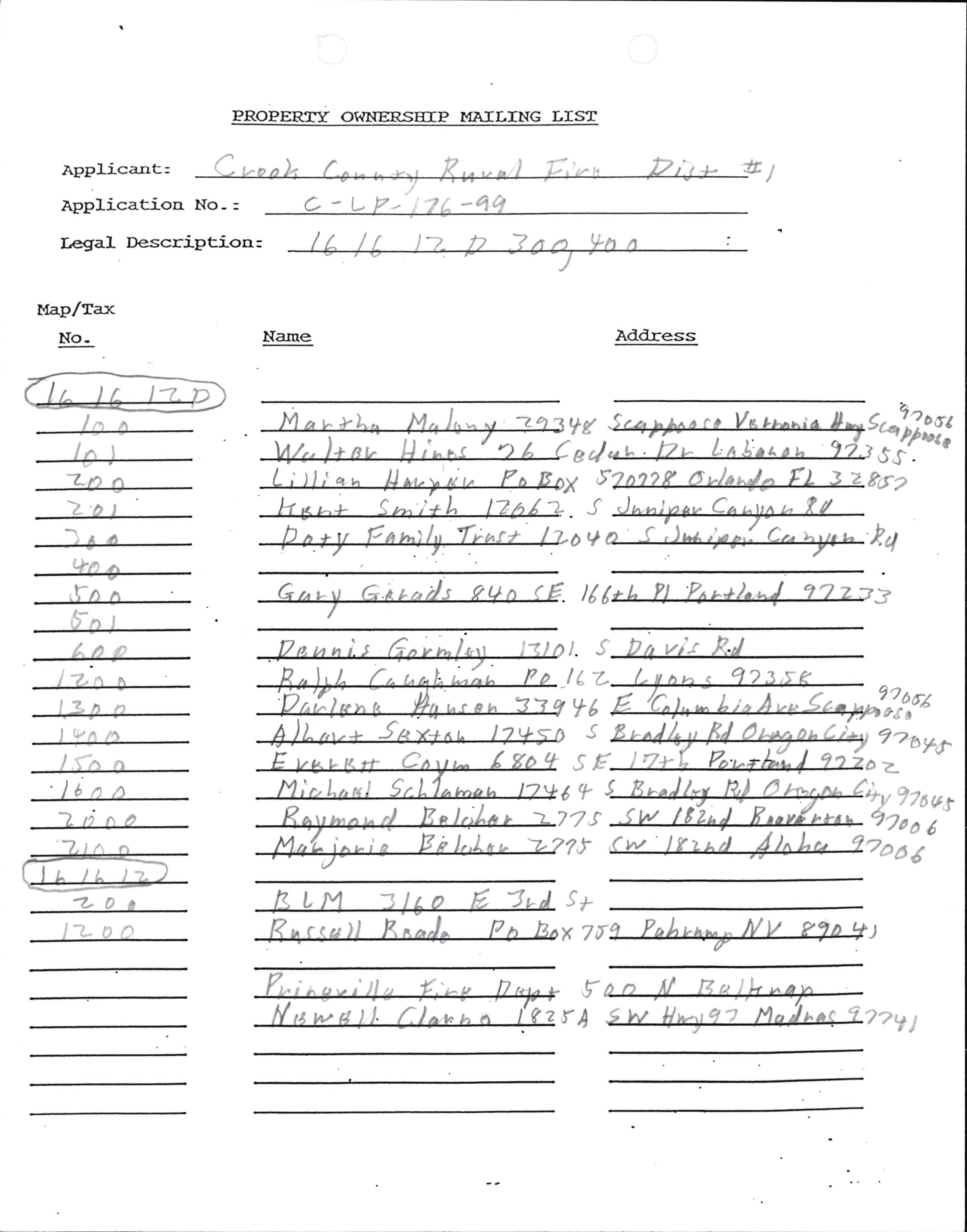
A PROPERTJr OWNER.SEIP MATLTNG LIST
I,egral Description: c ?{ ec/ t / -4
-t
vit
Z 2
Y6 s 7A "r Sy x7f r rA u':r' 7066 9coq ?z-brt o7 4.a n
..'l
(7ou -t
ir Lrul 9r L'|a*at" l?t!5 f '?? .t I ti" ,".rt,/l ?? ? '2 ?"vl + /t /r )=- 17 -7n.t tlnn : J ttt ) -Lr o 2'o t ,t-a Name Address 7- rt ''by'rr. ln> ) _? I F,,i^g-'rl u f,'{ .liobf ly'$wrtJtC'rvna tt(z I
Map./rax Noln bnl Jnn)rn, Ca ula u f / lr. bv n la Gr,>rt G.tto)s ?Uo (E l{ (* ll h "il. "l z't z
Deun i.s Gnv^lo.r- )-E)Dt , Dt
Rl .IL
/,
l{a
Fvgr6rt'CnVt
l"l
COT]NTY OF CROOK
FOR
PARTITIONING AS CONDITIONAL USE
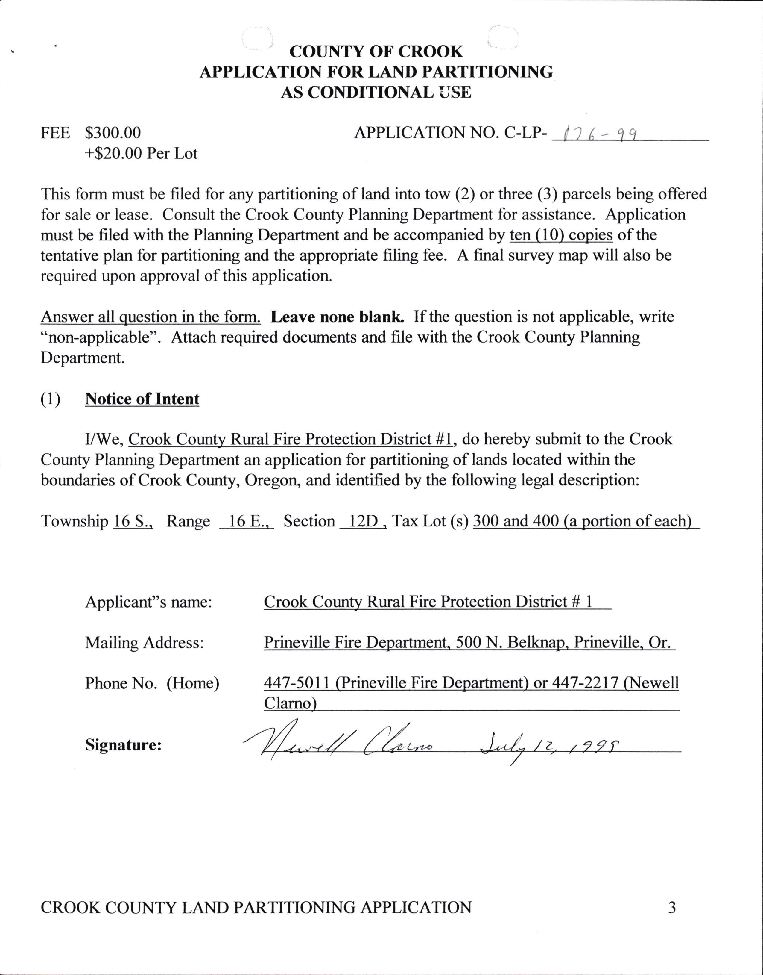
This form must be filed for any partitioning of land into tow (2) or three (3) parcels being offered fbr sale or lease. Consult the Crook County Planning Department for assistance. Application must be filed with the Planning Department and be accompanied by ten (10) copies of the tentative plan for partitioning and the appropriate filing fee. A final survey map will also be required upon approval of this application.
Answer all question in the fonn. Leave none blank If the question is not applicable, write "non-applicable". Attach required documents and file with the Crook County Planning Department.
(l) Notice of Intent
I/We, Crook County Rural Fire Protection District #1, do hereby submit to the Crook County Planning Department an application for partitioning of lands located within the boundaries of Crook County, Oregoq and identified by the following legal description:
Township l6 S.. Range l6 E.. Section l2D . Tax Lot (s) 300 and 400 (a portion of each)
Applicant"s name: Crook CounW Rural Fire Protection Distris!4 1 Mailing Address: Prineville Fire Department. 500 N. Belknap. Prineville. Or Phone No. (Home) 447-501 I (Prineville Fire Department) or 447-2217 (Newell Clarno)
Signature:
I . ci q
APPLICATION
LAI\ID
FEE $300.00 +$20.00 Per Lot APPLICATION NO. C-LP- 0
a J CROOK COUNTY LAND PARTITIONING APPLICATION
(2) General Information
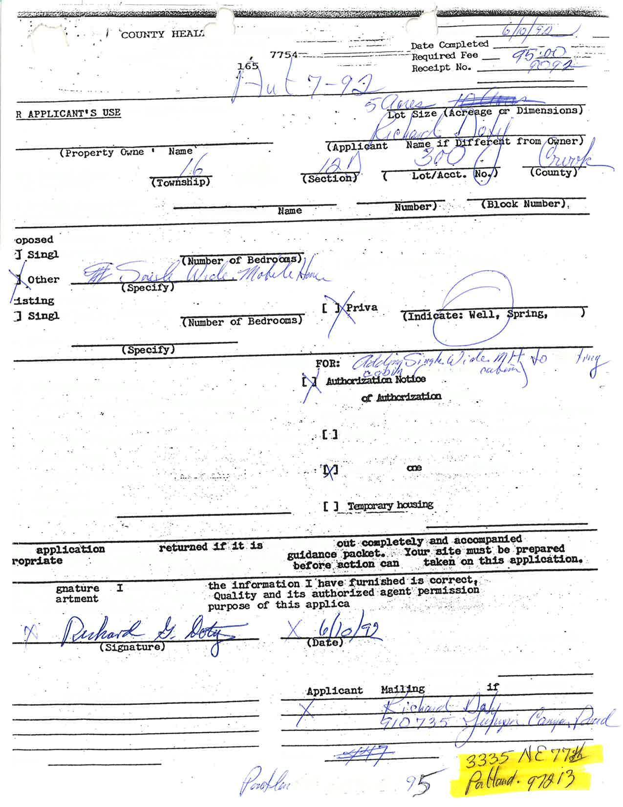
A. Full name of owner of record (If different from applicant): Dot'v Family Trust
Signature (s) :
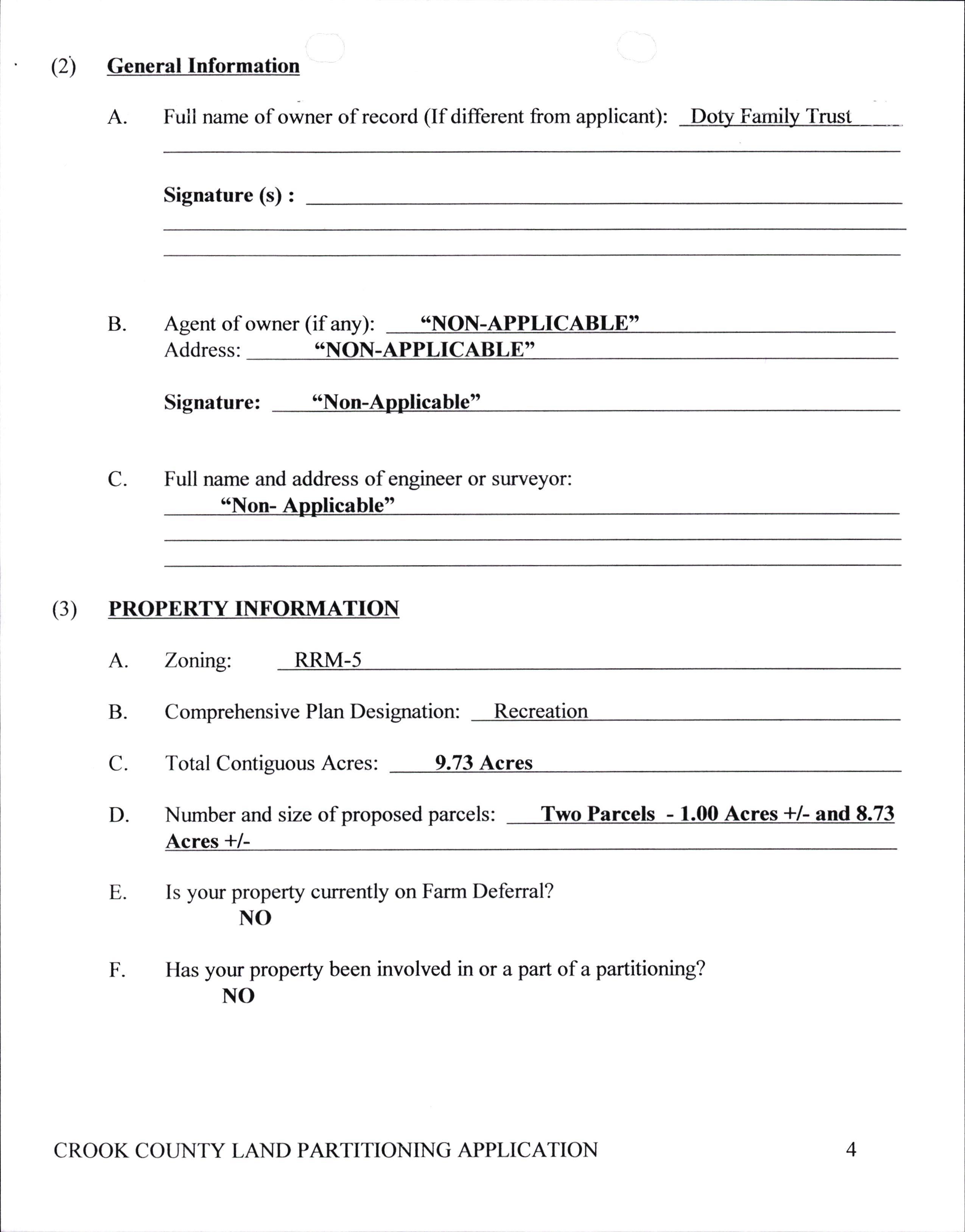
B. Agent of owner (if any): *NON-APPLICABLE' Address: *NON.APPLICABLE'
Signature: "Non-Applicable"
C. Full name and address of engineer or surveyor: ttNon- Aoolicable"
(3) PROPERTY TNFORMATTON
C. D. E. Comprehensive Plan Designation:
Total Contiguous Acres: 9.73
Number and size of proposed parcels: Acres */Two Parcels - I Acres +/- and 8-73
4 CROOK COUNTY LAND PARTITIONING APPLICATION
A. Zonng: RRM-5 B.
Recreation
Acres
F Is your property currently on Farm Defenal? NO Has your property been involved in or a part of a partitioning? NO

(4) Parcel Use Intent
A. For what use or uses are the parcels now used? The oarcel on the side of the road is utilized for a sinsle residence. while the parcel on the south side of the road is non-use.
B The property has been/is under cultivation? NO
C For what use or uses are the parcels intended?
_Agicultural, no dwelling (s)
_Agicultural, farm dwelling (s)
X Residential Homesite (s)
_Commercial Industrial
X Other ( Please describe) The second parcel. the on the south side of the side of the road (l acre) will be used for a "Fire Sub-Station"
(5) Irrigation Water
A. B.
C. The property has irrigation water assigned? NO
If there is irrigation water assigned, you must submit a completed "Water Rights Diversion Plan:.
If property is not in an irrigation district, sigh-offfrom the State Watermaster is required.
(6) Geographic Location and Physical Aspects
A. Geographical location of development: The parcels are located along Juniper Canvon Road. iust North of "Hood's Subdivision"
B. Is it in a Critical Wildlife Area? NO
5 CROOK COUNTY
PARTITIONING
LAND
APPLICATION
C. How many miles by Cot-,"y or State Road from Prineville? rarcels are I atMP8on
D Topography: ( Level, rolling, hilly, rocky, ect.)
Level
E. Drainage: [s land subject to flooding? NO
F. Soils ( as determined by the SCS Office): N/A
(3) Senices and Improvements
A. Water will be supplied by:
Community system
Other (specify)
X Individual Wells
B. Sewage Disposal - will be disposed by:
Septic Tank
X Other (speciff) Tank/Drain Field located on ad
Community Drainfield
6 CROOK COUNTY LAND PARTITIONING APPLICATION
If septic tanks are to be used rur Sewsge disposal, submit an approvar from local Health Department showing that septic tanks maybe used upon the parcel being proposed.
C. Electricity and Telephones:
(l) Utility Company Service District: Central Electric C Inc
(2) Are utilities available to the property? YES
D. Fire Protection:
(l ) What provisions are or will be made available for fire protection? N/A
(2) Name of Fire Department or Fire District, if any: Crook County Rural Fire Protection District #1. Prineville Fire Department
E. Streets and Roads:
(l) Are streets bounding tracts public streets? YES
If not, explain on separate sheet (or on back) how purchasers will have legal access to the track.
(2) Are streets to parcels now dedicated? YES
If not, will they be dedicated? N/A
7 CROOK COUNTY LAND PARTITIONING APPLICATION
(3) Are streets ru the tract now surfaced: YES
lf not, will they be surfaced? YES What type of surface:
Who will pay for the surfacing?
Public Transportation and School Bus: Is it available to the properfy? YES If not, how far?
(8) Explain how your partitioning is in compliance with the Crook County Comprehensive Plan ( be specific): Area is Zoned RRM-5 (Residential, Recreational, Manufactured Home). Partitioning would allow CCRFPD#I to establish a Fire Sub-Station in Juniper Canyon, thus allowing the District to acquire addition Fire Fighting Equipment which would be housed at the Sub-Station. This would decrease response time by approximately %how. This would enhance both the "Safety and Welfare" of the Upper Juniper Canyon Area.
(9)
Explain how your partitioning will have no adverse impact upon the ( be specific): Partitioning would have a favorable impact on the Upper Juniper Canyon Area as it would enhance both "Safety and Welfare" of the area.
A. Adjoining land uses: Parcels to the north of Juniper Canyon are use as residential, while adjoining parcels to the south, "Hoods's Subdivision" are used as either parttime residential or recreational. Parcels to the West are use as small farmsresidential with one parcel, tax lot 501 is Commercial.
Public Services and Facilities: Public roads (Juniper Canyon Road) is the boundary of the parcels. Both power and phone are adjacent to the property.
Natural Resource carrying capacities: Partitioning, which would allow the construction of a "Fire Sub-Station" would enhance the Natural Resources as it would provide better Fire Protection.
F B C 8 CROOK COUNTY LAND PARTITIONING APPLICATION N/A N/A N/A
D
Livability of the <'wor Parcels to the north of Juniper r.,ar[or are use as residential, while adjoining parcels to the sout[ "Hoods's Subdivision" are used as either parttime residential or recreational. Parcels to the West are use as small farmsresidential with one parcel, tax lot 501 is Commercial. Said partitioning would not change the area.
Value of abutting properties: Values range from a low of $5,000 for a two acre undeveloped lot (PLA I and II) to values over $200,000. The average developed property would be around $95,000.
Appropriate development of abutting properties and the surrounding area: The abutting area is developing, there are new homes on lots l0l, 102, and 1300. The surrounding area has two new subdivisions, "Ironwood" and "Airport Park". Prineville Lake Area I and II are being developed.
( l0) What are the sizes of the surrounding properties (orvnerships, not tax lots)? Properties range from 33 acres to 1.82 acres.
(11) What are the predominate soils' classes of the proposed parcels? (Please consult the Prineville Area Soil Survey of the Soil Conservation Service, available at the SCS Office at 350 N. Dunharn, Prineville). N/A
(12) Explain how your partitioning is compatible with farm uses. N/A
( l3) Explain how your partitioning will not interfere seriously with accepted farming practices on adjacent lands devoted to farm use.
Partitioning and construction of a Fire Sub-Station would enhance the farming in the area as it would provide better Fire Protection.
E F 9 CROOK COUNTY LAND PARTITIONING APPLICATION

CROOK COUNTY LAND PARTITIONING APPLICATION l0
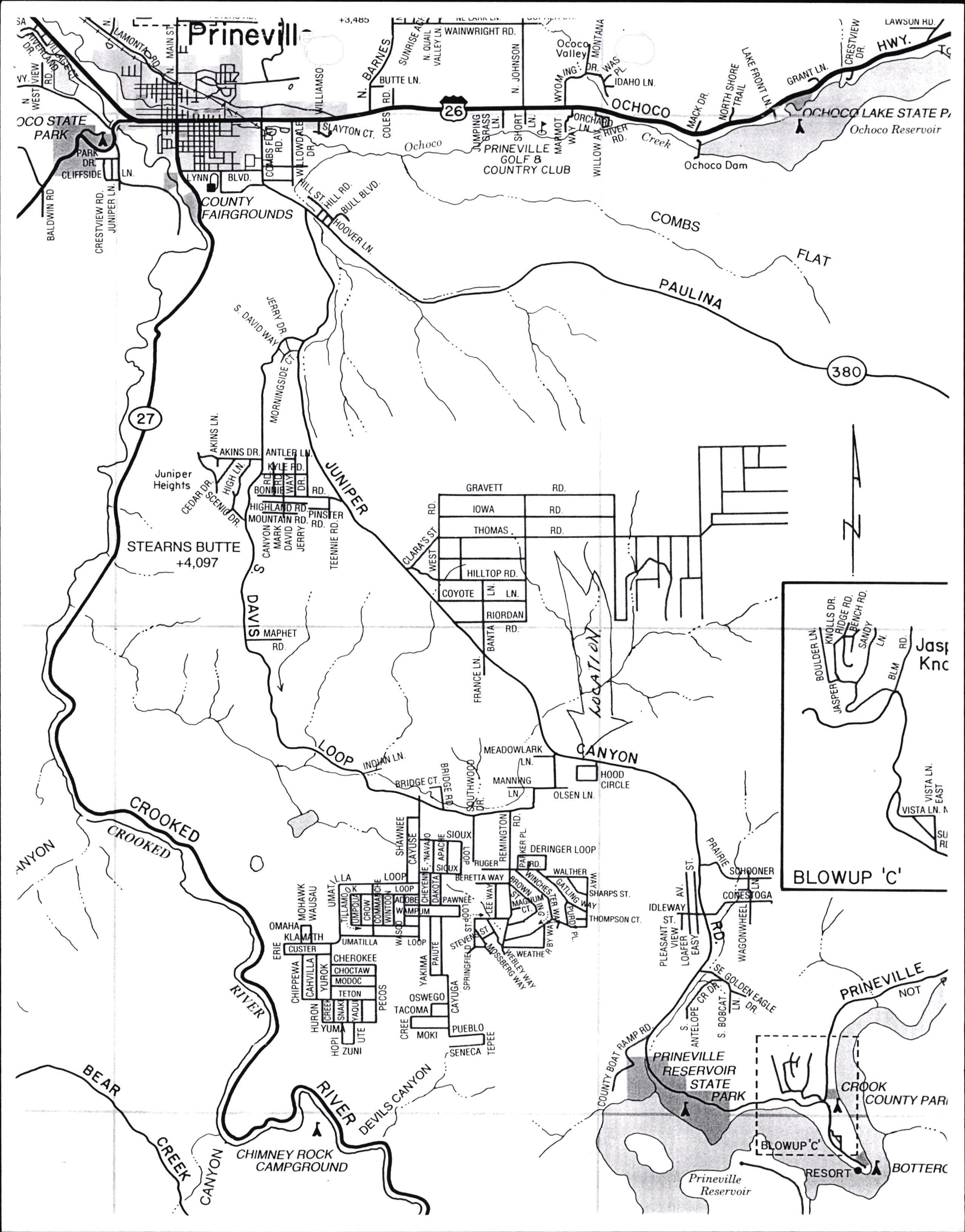
JA )co ,/y z L-tnev +J,455 z. 'r" -' LAWSUN Y STATE P, Ochoco Reseruoir z = =1iY.; o LN, cHoco oe z PR'NEVILLE GOLF 8 COUNTRY CLUE B o i Ochoco Dom YNN i oJ EE =H >l E $s at.' = o q FLqr 2a (t "a I ,Z ou qL./o i \ \\ \ z = OR, Juniper Heighls GRAVETT RD ci d \ STEARNS BUTTE +4,097 E o ea to \ ci E Josl Knc ( N H000 CIRCTE z FF =fi OTSEN LN DERIIIGER LOOP € a I \ .u*> -\= I 8t ) o u BLOWUP ,C. L =i Io< == = ) ST ST. == <qg d o U; z o & = , r I I I I I ZUNI d oCT E E a = C g I = IACOMA F l 5 MoKr "u9^ "Y STATE Reseruoir PARr I ? o CHIMNEY ROCK CAMPGROUND o zo z WAINWRIGHT RO. 6q "-S LN, JZ ai Bq Ochoco ct. JE' 8LVO. Q o ot=E RO, t0wA RD THOMAS R0. I ,,..,.r0, ^o. \ COYOIE 3 r-ru. RIORDAN 0 z z E RD. RO I ) MEADOWLARK uN CT o ez zYo> OE= E ?=3 q CUSIER 5 =o G ) ! "---r,- ".-\.-_:grrr" \ l \
Planning Inquiry
300
NE 3rd St, Rm #12 Prineville,OR 97754 Phone: 541-447-3211 Fax: 541-416-2139 CROOK COUNTY co.crook.or.us
Inspection Summary Report bld@co.crook.or.us
RURAL FIRE PROT DIS #1,
NE BELKNAP ST, PRINEVILLE, OR, 97754
Print Date: 4/15/2024 Page 1 of 1
Permit #: 217-23-000337-NQRY Owner: DOTY FAMILY TRUST, 12040 SE JUNIPER CANYON RD, PRINEVILLE, OR, 97754,CROOK COUNTY
500
IVR # 217090649089 161612D000301 Parcel: 12051 SE JUNIPER CANYON RD PRINEVILLE OR 97754 Address: Inspection Type: Inspection Result: Inspection Date: Inspector: Comments: Inspection in a Floodplain: No Schedule Inspections online at: www.buildingpermits.oregon.gov or by calling: 1-888-299-2821 Use IVR # 217090649089 Schedule using the Oregon ePermitting Inspection App, search “epermitting” in the app store