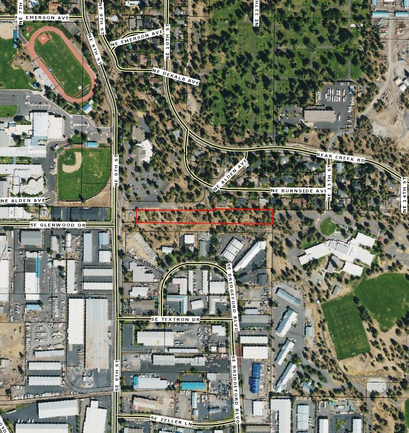
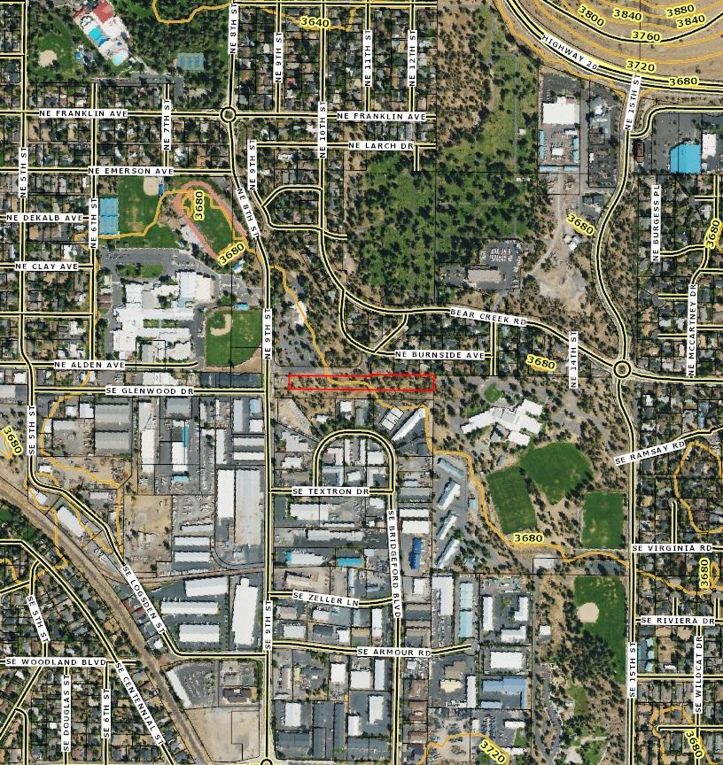
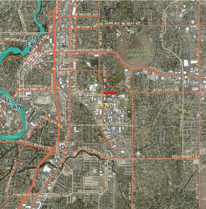
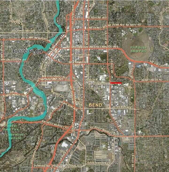
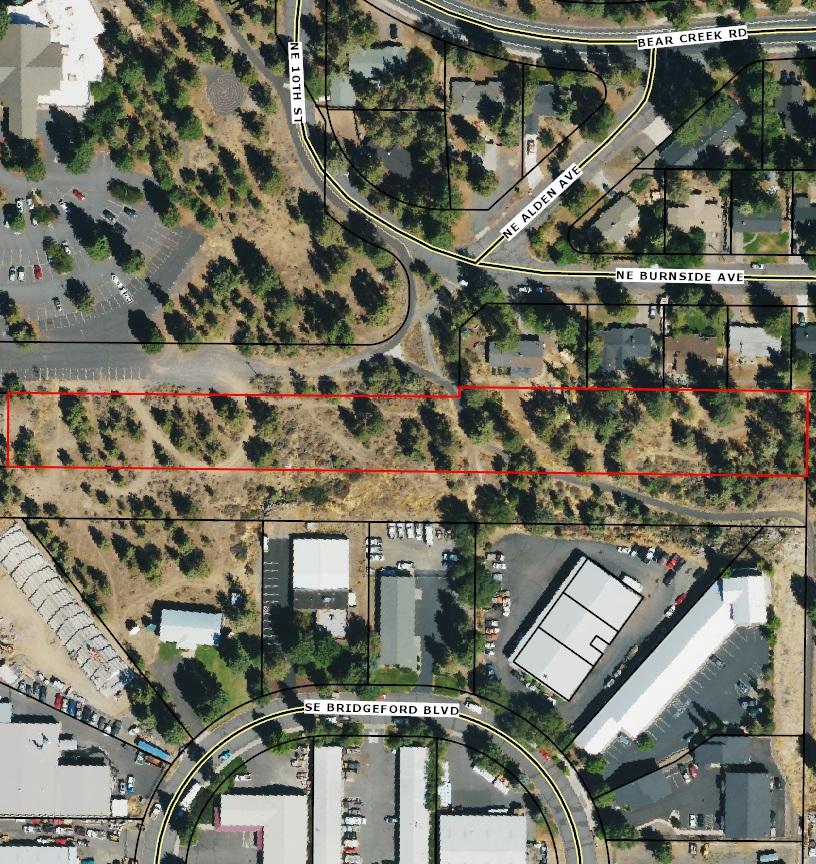
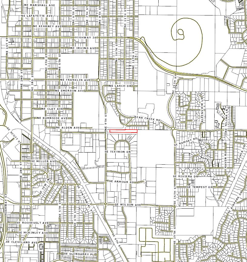
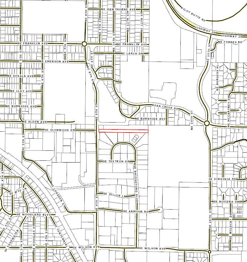
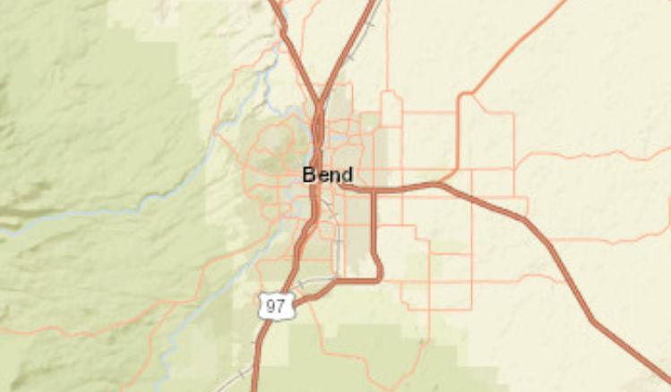
Market Profile
10 SE 9th St, Bend, Oregon, 97702
Rings: 1, 3, 5 mile radii
2020 Households by Tenure and Mortgage Status
Data Note: Households with children include any households with people under age 18, related or not. Multigenerational households are families with 3 or more parent-child relationships. Unmarried partner households are usually classified as nonfamily households unless there is another member of the household related to the householder. Multigenerational and unmarried partner households are reported only to the tract level. Esri estimated block group data, which is used to estimate polygons or non-standard geography.
Source: Esri forecasts for 2024 and 2029. U.S. Census Bureau 2000 and 2010 decennial Census data converted by Esri into 2020 geography. December 05, 2024
Data Note: Consumer spending shows the amount spent on a variety of goods and services by households that reside in the area. Expenditures are shown by broad budget categories that are not mutually exclusive. Consumer spending does not equal business revenue. Total and Average Amount Spent Per Household represent annual figures. The Spending Potential Index represents the amount spent in the area relative to a national average of 100.
Source: Consumer Spending data are derived from the 2019 and 2020 Consumer Expenditure Surveys, Bureau of Labor Statistics. Esri. Source: Esri forecasts for 2024 and 2029. U.S. Census Bureau 2000 and 2010 decennial Census data converted by Esri into 2020 geography. December 05, 2024
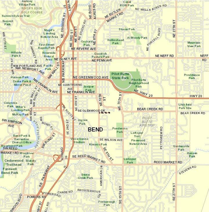
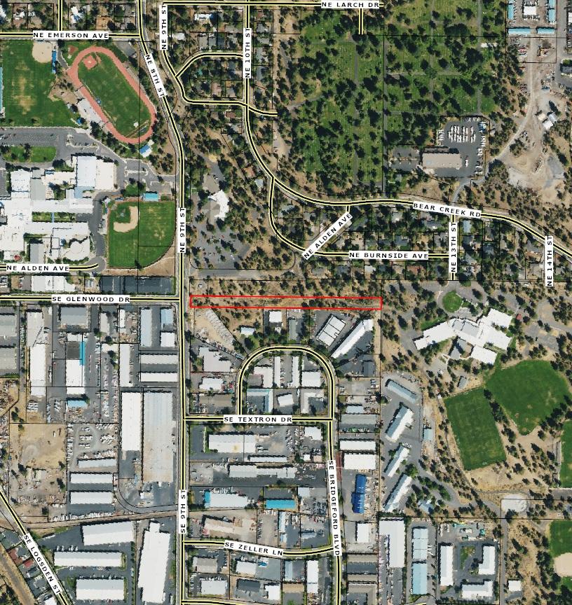
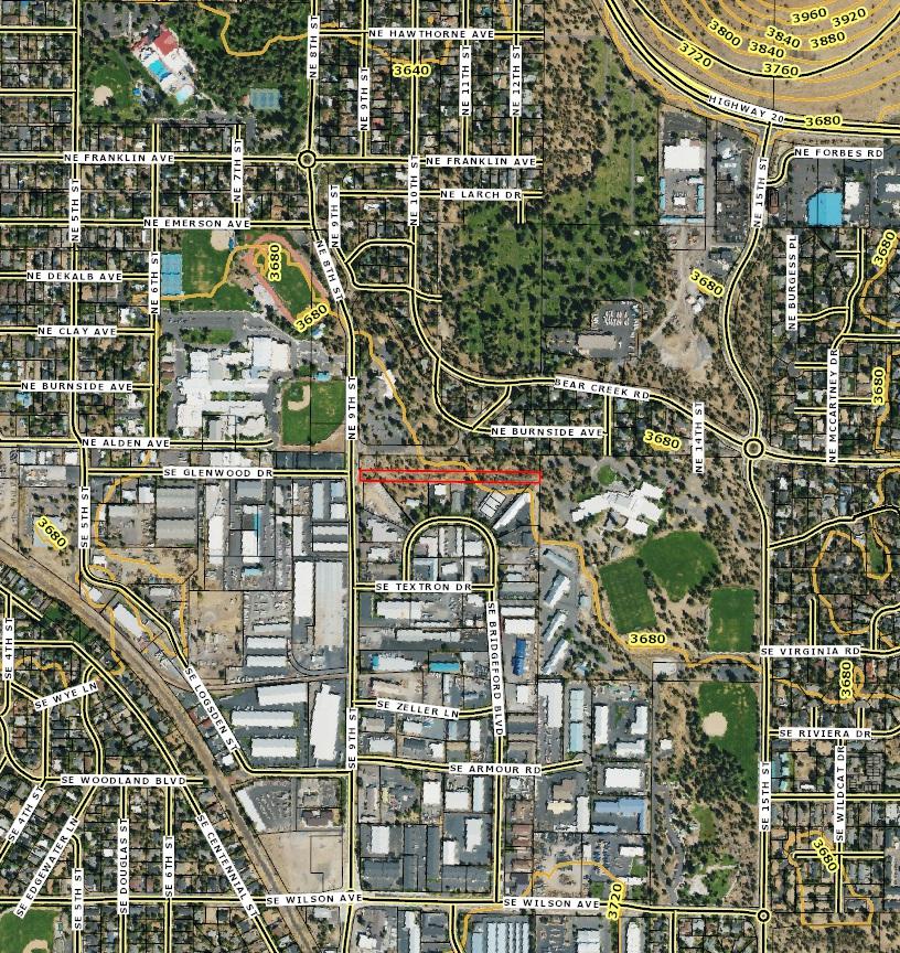
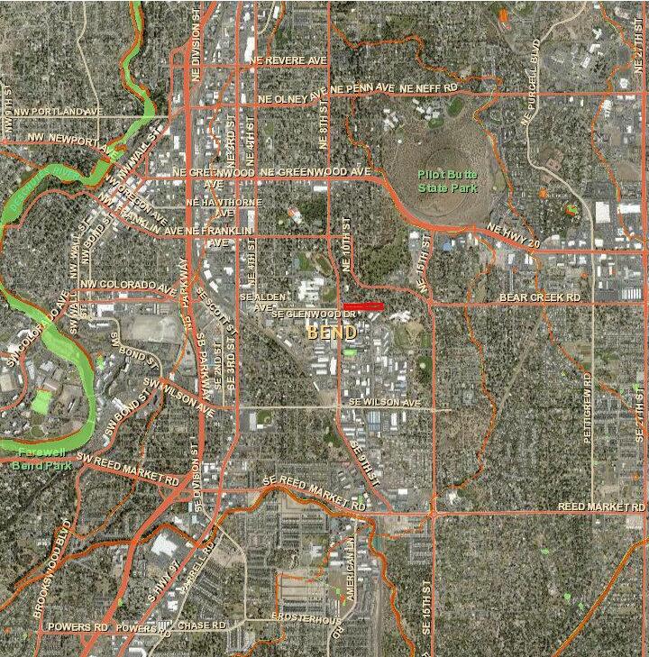
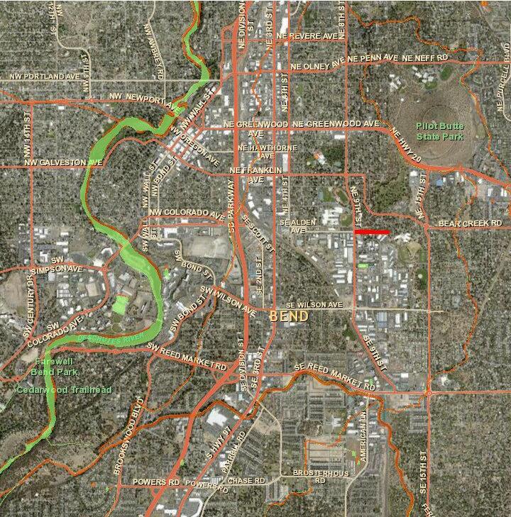
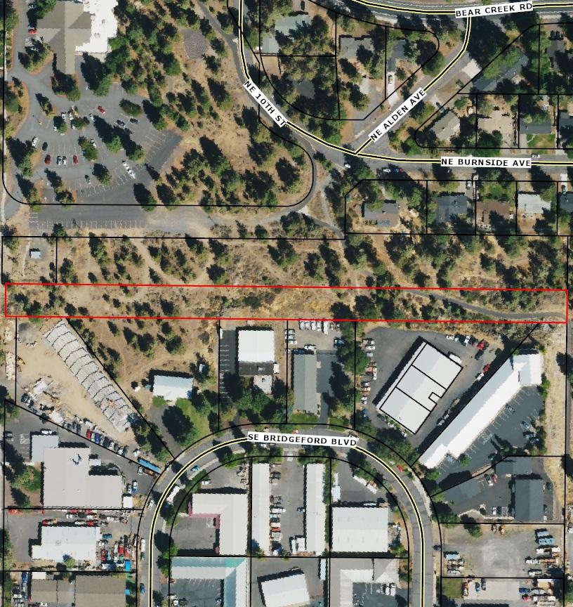
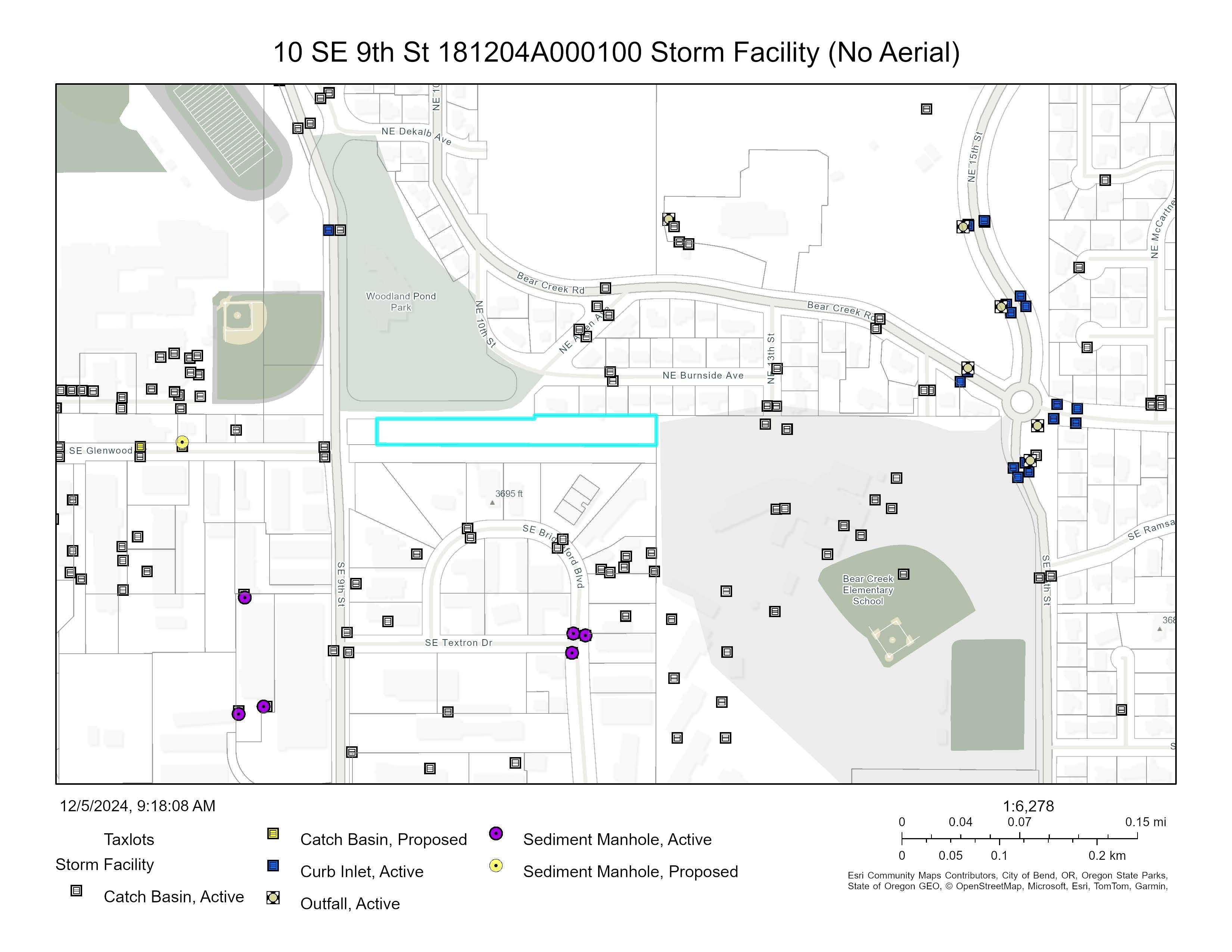
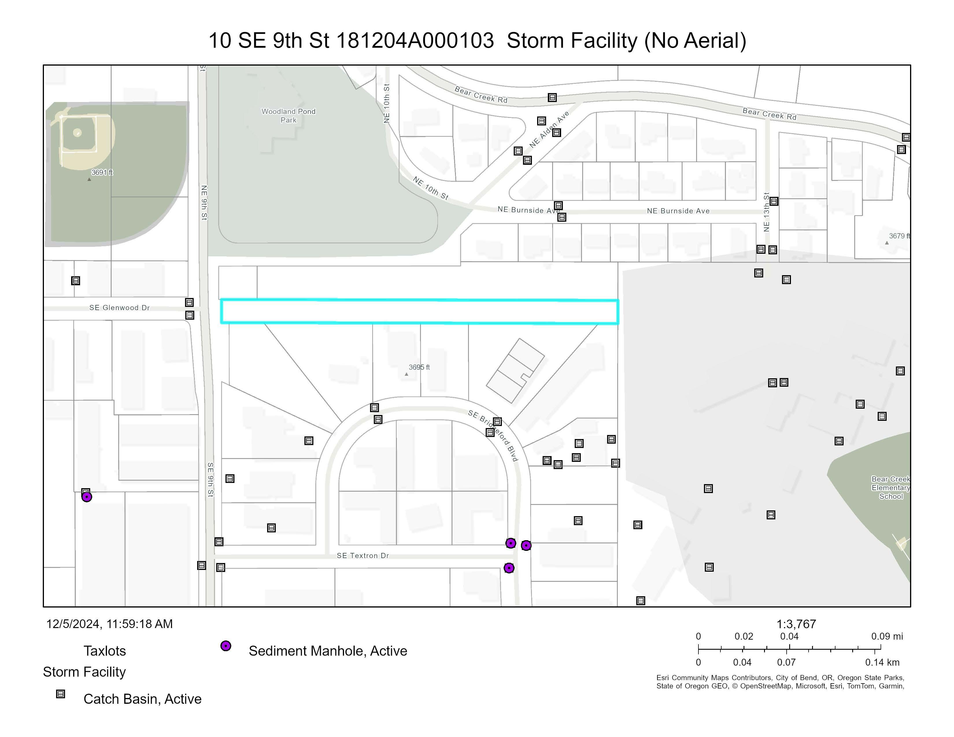
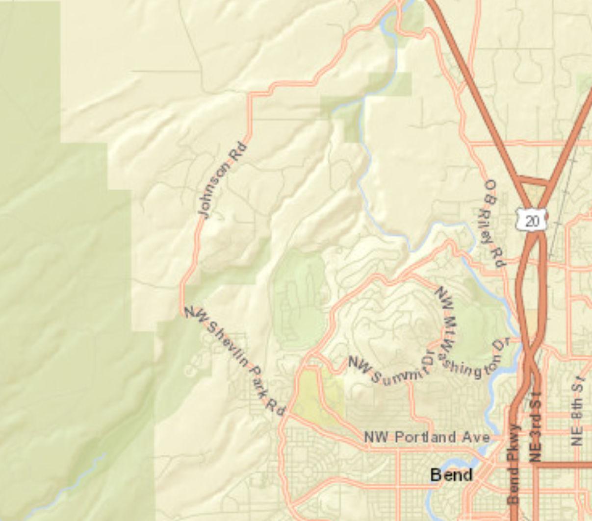
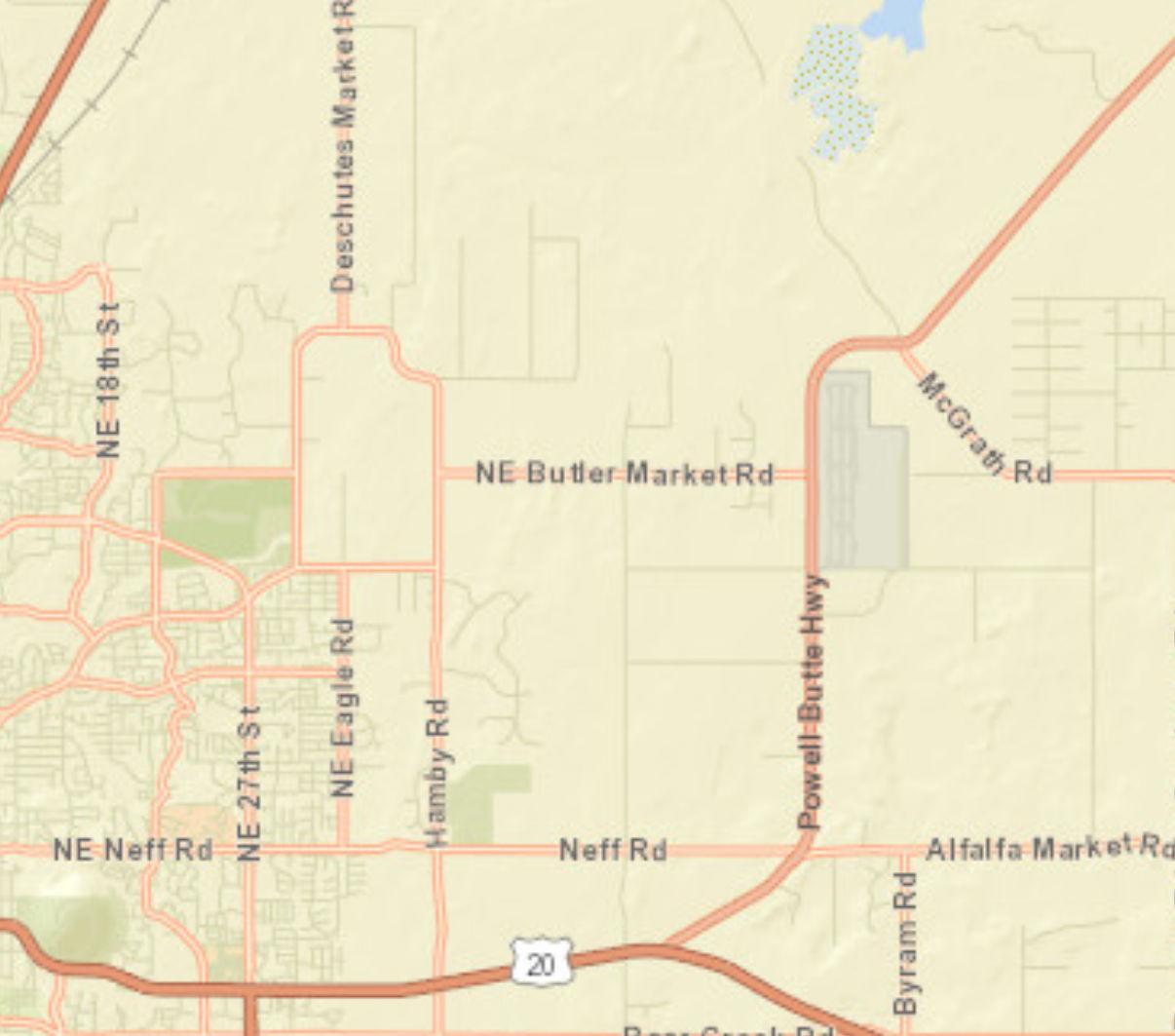
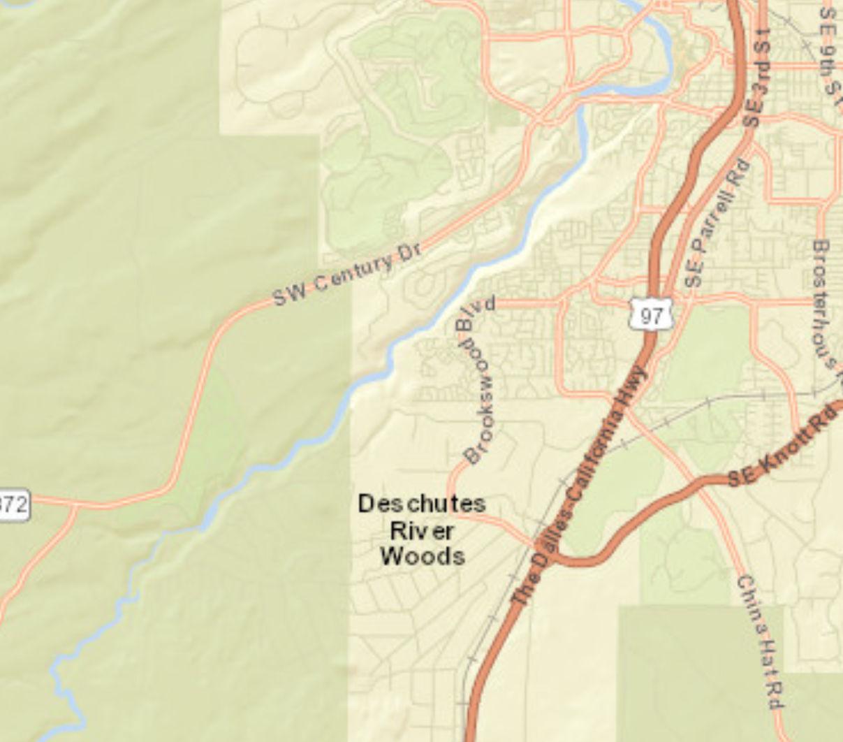
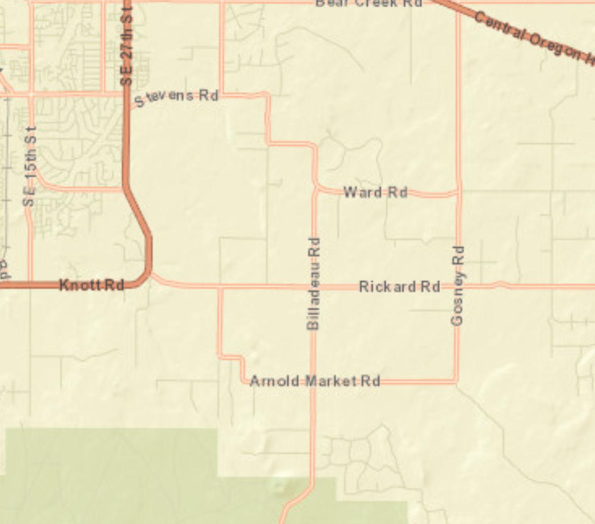
Traffic Count Map
10 SE 9th St, Bend, Oregon, 97702
Prepared by
Rings: 1, 3, 5 mile radii Latitude: 44.05121 Longitude: -121.29051
Source: ©2024 Kalibrate Technologies (Q3 2024).
December 05, 2024
Chapter 2.1RESIDENTIAL DISTRICTS (UAR, RL, RS, RM-10, RM, RH)Revised
https://bend.municipal.codes/BDC/2.1.200
Sections:
2.1.100Purpose, Applicability and Location.
2.1.200Permitted and Conditional Uses. Revised
2.1.300Setbacks.
2.1.400Repealed.
2.1.500Lot Area and Dimensions.
2.1.600Residential Density.
2.1.700Maximum Lot Coverage and Floor Area Ratio.
2.1.800Building Height.
2.1.900Architectural Design Standards.
2.1.950Design Standards (Triplex, Quadplex, Townhome, and Single-Room Occupancy).
2.1.1000Multi-Unit Residential Districts (RM, RH).
2.1.1100Other Design Standards.
2.1.100Purpose, Applicability and Location.
A. Purpose. Residential Districts are intended to promote the livability, stability, safety and improvement of the City of Bend’s neighborhoods based on the following principles:
•Make efficient use of land and public services, and implement the Comprehensive Plan, by providing density standards for housing.
•Accommodate a range of housing needs, including owner-occupied and rental housing.
•Provide for compatible building and site design at an appropriate neighborhood scale which reflects the neighborhood character.
•Reduce reliance on the automobile for neighborhood travel and provide options for walking and bicycling.
•Provide direct and convenient access to schools, parks and neighborhood services.
B. Applicability. This chapter applies to all development in the Urban Area Reserve District (UAR), Low Density Residential District (RL), Standard Density Residential District (RS), Medium-10 Density Residential District (RM-10), Medium Density Residential District (RM), and High Density Residential District (RH). These districts are identified on the City’s official Zoning Map. Properties designated within each district that contain additional standards must
comply with the provisions of the applicable district, except as may be modified by this section. Properties within a designated Historic District must comply with the provisions of BC Chapter 10.20.
Table
2.1.100. Zone District Characteristics
Zone District
Urban Area
Reserve (UAR)
Low Density
Residential (RL)
Standard Density
Residential (RS)
Medium-10 Density
Residential (RM-10)
Medium Density
Residential (RM)
High Density
Residential (RH)
Location and Characteristics
The Urban Area Reserve District is a holding zone for urban development. The maximum residential density for the district is 1 dwelling unit per 10 gross acres.
The Low Density Residential District consists of large urban residential lots that are served with a community water system and DEQ permitted community sewer, private on-site septic systems, or municipal sewer systems. The residential density range in this district is 1.1 to 4.0 dwelling units per gross acre.
The Standard Density Residential District is intended to provide opportunities for a wide variety of residential housing types at the most common residential densities in places where community sewer and water services are available. The residential density range in this district is 4.0 to 7.3 dwelling units per gross acre.
The Medium-10 Density Residential District is intended to provide opportunities for manufactured home park development and a variety of single- and multi-unit residential housing types. The density range in this district is 6.0 to 10.0 dwelling units per gross acre.
The Medium Density Residential District is intended to provide primarily for the development of multi-unit residential in areas where sewer and water service are available. The residential density range in the district is 7.3 to 21.7 units per gross acre and must provide a transitional use area between other Residential Districts and other less restrictive areas.
The High Density Residential District is intended to provide land for primarily high density multi-unit residential in locations close to shopping and services, transportation and public open space and to provide a transitional use area between other Residential Districts and other less restrictive areas. The minimum density of the district is 21.7 units per gross acre and there is no maximum density.
[Ord. NS-2487, 2023; Ord. NS-2423, 2021; Ord. NS-2361, 2020; Ord. NS-2353, 2019; Ord. NS2271, 2016; Ord. NS-2251, 2015; Ord. NS-2016, 2006]
2.1.200Permitted and Conditional Uses. This section was recently amended by Ordinance NS-2500, codified in July 2024.
A. Permitted Uses. The land uses listed in Table 2.1.200 are permitted in the Residential Districts, subject to the provisions of this chapter. Only land uses that are specifically listed in Table 2.1.200, land uses that are incidental and subordinate to a permitted use and land uses that are approved as “similar” to those in Table 2.1.200 may be permitted. The land uses identified with a “C” in Table 2.1.200 require conditional use permit approval prior to development, in accordance with BDC Chapter 4.4, Conditional Use Permits.
B. Determination of Similar Land Use. Similar use determinations must be made in conformance with the procedures in BDC 4.1.1400, Declaratory Ruling.
C. Exceptions. Existing uses and buildings lawfully established under previously effective land use regulations are allowed to continue subject to BDC Chapter 5.2, except as otherwise specified in this section.
1. Existing dwelling units that were lawfully established in their current location are treated as permitted uses in the residential zones unless originally approved through a conditional use permit, in which case they must remain subject to any applicable conditions of approval. Such uses are not subject to BDC Chapter 5.2 unless otherwise nonconforming.
D. Conversions.
1. Duplex. Conversion of an existing single-unit detached dwelling to a duplex is allowed; provided, that the conversion does not increase nonconformance.
2. Triplex and Quadplex. Conversion of an existing single-unit detached dwelling or duplex to a triplex or quadplex is allowed; provided, that the conversion does not increase nonconformance.
Conditional Uses
*Accessory dwelling units (ADUs)
*Manufactured homes on individual lots
*Manufactured home park
care home (5 or fewer residents)
Residential care facility (6 or more residents)
Table 2.1.200 – Permitted and
Family childcare home (16 or fewer children)
*Multi-unit residential (more than 4 units)
Micro-units. See BDC Chapter 3.8.200 N
*Home business (Class A/Class B/Class C)
*Accessory uses and structures
Cottage housing development. See BDC 3.8.500
Cottage cluster development. See BDC 3.8.900
*Public and Institutional
Places of worship
Clubs, lodges, similar uses
*Government offices and facilities (administration, public safety, utilities, and similar uses)
Libraries, museums, community centers, and similar uses
*Utilities (above ground)
care facility (17 or more children)
*Neighborhood Commercial (See 3.6.300(J))
Child care facility (13 or more children)
*Food and beverage services less than 2,000 square feet (with or without alcohol)
Laundromats and dry cleaners
Retail sales and services
Personal services (e.g., barber shops, salons, similar uses)
Repair services, conducted entirely within building; excluding vehicle repair, small engine repair and similar services
Offices and clinics
Mixed-use building
*Miscellaneous Uses
Bed and breakfast inn
Boarding kennel
Destination resorts
Diagnostic testing, counseling, administrative offices, meeting facilities for nonprofit and public community service programs for children and families.
Farm use, agriculture
Office uses lawfully existing prior to the adoption date of the ordinance codified in this code
*Plant nursery
• Existing
• New (limited to 1 acre)
• New (larger than 1 acre)
*Shelters
*Short-term rental
*Small hydroelectric facility
Veterinary clinic
• Small animal (only)
• Large animal
Wireless and broadcast communication facilities See BDC Chapter 3.7
Key to Districts:
UAR = Urban Area Reserve
RS = Standard Density Residential
RL = Low Density Residential
RM = Medium Density Residential
RM-10 = Medium-10 Density Residential RH = High Density Residential
Key to Permitted Uses
P = Permitted, subject to BDC Chapter 4.1, Development Review and Procedures
N = Not Permitted
C = Conditional Use, subject to permit standards in BDC Chapter 4.4.
*Subject to special standards as described in BDC 2.1.900, Architectural Design Standards, and/or BDC Chapter 3.6, Special Standards and Regulations for Certain Uses.
**Permitted as part of a master plan subject to BDC Chapter 4.5
***Neighborhood commercial sites adjacent to a commercial or mixed-use Comprehensive Plan map designation, or the Bend Central District Special Planned District. See BDC 3.6.300(J), Neighborhood Commercial Sites.
Note: Existing Neighborhood Commercial (CN) Zoned properties will remain as mapped recognizing neighborhood commercial properties established prior to the adoption of this code. The development of these sites must conform to the standards outlined in BDC Chapter 3.6, Special Standards and Regulations for Certain Uses, for the uses described above. [Ord. NS2500, 2024; Ord. NS-2487, 2023; Ord. NS-2463, 2023; Ord. NS-2443, 2022; Ord. NS-2423, 2021; Ord. NS-2389, 2020; Ord. NS-2353, 2019; Ord. NS-2303, 2018; Ord. NS-2289, 2017; Ord. NS-2271, 2016; Ord. NS-2264, 2016; Ord. NS-2260, 2016; Ord. NS-2251, 2015; Ord. NS2241, 2015; Ord. NS-2240, 2015; Ord. NS-2158, 2011; Ord. NS-2016, 2006]
2.1.300Setbacks.
A. Purpose. Setbacks provide private outdoor living space, building separation for fire protection/security, building maintenance, and sunlight and air circulation. The setback standards encourage placement of residences close to the street for public safety and neighborhood security.
B. Setback Standards. The following setback standards apply to all structures, except as otherwise provided by this section or specified in this code. See also special setbacks permitted in BDC 3.6.200, Special Standards for Residential Uses, and BDC Chapter 3.8, Development Alternatives.
C. Front Setbacks.
1. RL and UAR Districts. The minimum front setback is 20 feet.
a. Exception. On lots with multiple frontages within a platted land division, the 20-foot front setback must be applied to one of the frontages and the other frontages may be 10 feet; provided, that a garage and/or carport with a street access is set back a minimum of 20 feet.
2. RS, RM-10, RM, and RH Districts. The minimum front setback is 10 feet. Garages and carports with street access must be set back a minimum of 20 feet from the front property line.
3. Where streets with insufficient right-of-way abut the site, special setbacks apply in conformance with BDC 3.4.200(J), Special Setbacks.
D. Rear Setbacks.
1. RL and UAR Districts. The minimum rear setback is 20 feet.
Exception. In the RL Zone on corner lots within a platted subdivision, the minimum rear setback is 10 feet.
2. RS, RM-10, RM and RH Districts. The minimum rear setback is five feet.
Exception: Development in conformance with the provisions of BDC Chapter 3.8, Development Alternatives.
E. Side Setbacks.
1. RL and UAR Districts. The minimum side setback is 10 feet.
2. RS, RM-10, RM and RH Districts. The minimum side setback is five feet.
Exception: Development in conformance with the provisions of BDC Chapter 3.8, Development Alternatives.
Table 2.1.300 – Typical Residential District Setbacks
RS 10 ft., except garages and/or carports must be set back 20 ft. 5 ft.* 5 ft.*
RM-10, RM and RH 10 ft., except garages and/or carports must be set back 20 ft. 5 ft.* 5 ft.*
*When multi-unit residential, single-room occupancies with more than six units or nonresidential uses abut one or more dwelling units in the RL or RS District, the setback abutting the RL or RS District must increase one-half foot for each foot by which the building height exceeds 20 feet. Where a fractional number results, the number may be rounded down to the nearest whole number.
F. Additional Setback Requirements.
1. Garages and Carports.
a. Where the side or rear wall of the garage faces the street, the front setback for the garage side or rear wall must be a minimum of 10 feet from the front property line for RS, RM, RM-10 and RH and 20 feet for RL. The garage must have a window(s) in the side or rear wall facing the street that is a minimum of six square feet.
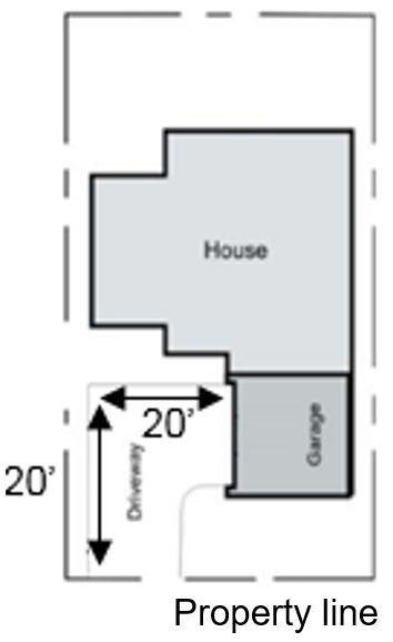
b. Alley Access. Where an existing alley is less than 20 feet in width, the setback abutting the alley must be increased to provide a minimum of 24 feet for maneuvering and backing movements from garages, carports and/or parking areas. As shown in Figure 2.1.300, side entry garages that access an alley must also have a driveway with a minimum length of 20 feet from the garage door to the side property line.
c. Street Access. As shown in Figure 2.1.300, side entry garages that access a street must have a driveway with a minimum length of 20 feet from the front and side property lines.
Figure 2.1.300.
2. Townhomes. Setbacks for lot lines where townhouse units are attached are zero.
3. Clear Vision Areas. All structures must comply with this section, except as necessary to comply with BDC 3.1.500, Clear Vision Areas.
4. Bridges. Bridges that form the driveway or pedestrian access from the abutting street or alley are permitted in the setbacks.
5. Architectural Features. Except as prohibited in subsection (F)(6) of this section, the following architectural features are allowed to encroach into the front, side and rear setbacks by no more than two feet provided a minimum setback of three feet is provided from the property line: eaves, chimneys including fireplace enclosures and chimney chases, bay windows up to eight feet in width, window wells, and similar architectural features.
6. Front Setbacks. The following may encroach into the front setback:
a. RL and UAR. An unenclosed covered or uncovered porch, patio, deck or stoop with a maximum floor height not exceeding 18 inches may be set back a minimum of 10 feet, as long as it does not encroach into a public utility easement. No portion of the structure can encroach closer than 10 feet including the architectural features in subsection (F)(5) of this section.
b. RS, RM, RM-10 and RH. An unenclosed covered or uncovered porch, patio, deck or stoop with a maximum floor height not exceeding 18 inches may be set back a minimum of six feet from the front property line, as long as it does not encroach into a public utility easement. No portion of the structure can encroach closer than six feet to the front property line including the architectural features in subsection (F)(5) of this section.
c. Stairs, ramps and landings that are not roofed or enclosed above or below the steps may be in the front setback when they follow the grade.
7. Side and Rear Setbacks. The following may encroach into the side and rear setback in the UAR, RL, RS, RM, RM-10 and RH:
a. An uncovered porch, patio, deck or stoop located above finished grade with a maximum floor height not exceeding 18 inches must be set back a minimum of 18 inches from the side and rear property lines, as long as it does not encroach into a public utility easement.
b. Uncovered patios at finished grade are exempt from setbacks as long as it does not encroach into a public utility easement.
c. Stairs, ramps and landings that are not roofed or enclosed above or below the steps may be in the side and rear setback when they are at ground level and follow the grade.
G. Prohibited in Setbacks. The following are prohibited, unless stated otherwise, within the following setbacks:
1. Front Setbacks. Satellite dishes greater than 18 inches in diameter, heat pumps and other similar objects.
2. Side and Rear Setbacks. Satellite dishes greater than 18 inches in diameter, heat pumps and other similar objects, unless screened for visual and noise abatement by a solid enclosure two feet higher than the object/use being screened.
3. Balconies. [Ord. NS-2487, 2023; Ord. NS-2463, 2023; Ord. NS-2423, 2021; Ord. NS-2389, 2020; Ord. NS-2353, 2019; Ord. NS-2314, 2018; Ord. NS-2303, 2018; Ord. NS-2289, 2017; Ord. NS-2260, 2016; Ord. NS-2251, 2015; Ord. NS-2082, 2007; Ord. NS-2016, 2006]
2.1.400Building Mass and Scale.
Repealed by Ord. NS-2423.
2.1.500Lot Area and Dimensions.
Lot areas and lot dimension standards for residential uses are listed in Table 2.1.500. For other residential uses listed in Table 2.1.200, the lot area and dimensions are subject to the type of residential structure being occupied. Lot development must be in conformance with BDC 2.1.600, Residential Density. Lot area and dimensions exceptions for affordable housing, see BDC 3.6.200(C).
Table 2.1.500. Lot Areas and Dimensions in the Residential Districts by Housing Type and Zone
Residential Use Zone Minimum Lot Area Minimum Lot Width/Depth Exceptions Single-Unit Detached Dwelling; Manufactured Homes on Lots (See BDC 3.6.200(E)); Residential Care Homes and Facilities (See BDC 3.6.200(J))
UAR 10 acres
Width: 300 ft. min. average lot width with a min. street frontage of 150 ft.
No exceptions permitted
RL 10,000 sq. ft.
RS RM10 4,000 sq. ft.
RM 2,500 sq. ft.
Width: 50 ft. at front property line
Depth: 100 ft.
Width: 40 ft. at front property line
Depth: 50 ft.
Width: 30 ft. at the front property line
Depth: 50 ft.
RH Not applicable Not applicable
Bulb of a cul-de-sac minimum width: 30 ft. min. at the front property line except for townhomes and flag lots
Except for townhomes, corner lots or parcels must be at least five feet more in width than the minimum lot width required in the zone
Lots or parcels existing prior to November 5,
Duplex, Triplex, and Quadplex. See BDC 3.6.200(H)
Single-Room Occupancy
See BDC 3.6.200(O)
RL Duplex: 10,000 sq. ft.
UAR Not applicable Not applicable 2021, that are less than 2,500 square feet in the RH Zone may have a triplex or a quadplex
Triplex: 10,000 sq. ft.
Quadplex: 10,000 sq. ft.
RS
RM10 Duplex: 4,000 sq. ft.
Triplex: 4,000 sq. ft.
Quadplex: 4,000 sq. ft.
RM Duplex: 2,500 sq. ft.
Triplex: 4,000 sq. ft.
Quadplex: 4,000 sq. ft.
RH Duplex: 1,250 sq. ft.
Triplex: 2,500 sq. ft.
Quadplex: 2,500 sq. ft.
Width: 50 ft. at front property line
Depth: 100 ft.
Development alternatives: see BDC Chapter 3.8
Width: 40 ft. at front property line
Depth: 50 ft.
Width: 30 ft. at the front property line
Depth: 50 ft.
UAR Not applicable Not applicable
RL 10,000 sq. ft.
RS
RM10 4,000 sq. ft.
RM 4,000 sq. ft.
Width: 50 ft. at front property line
Depth: 100 ft.
Width: 40 ft. at front property line
Depth: 50 ft.
Townhomes
See BDC 3.6.200(D)
RH 2,500 sq. ft.
Width: 30 ft. at front property line
Depth: 50 ft.
UAR Not applicable Not applicable
RL, RS, RM10, RM Average minimum lot or parcel size: 1,500 sq. ft. for each unit
RH Average minimum lot or parcel size: 1,200 sq. ft. for each unit
Width: 20 ft. at front property
Depth: 50 ft.
Multi-Unit Dwelling (more than 4 units)
UAR Not applicable Not applicable
RL*, RS*, RM10 4,000 sq. ft. for each unit
RM, RH None
Width: 30 ft. at front property line
Depth: 50 ft.
*When permitted as part of a master plan subject to BDC Chapter 4.5, Master Plans.
[Ord. NS-2487, 2023; Ord. NS-2434, 2022; Ord. NS-2423, 2021; Ord. NS-2389, 2020; Ord. NS2361, 2020; Ord. NS-2353, 2019; Ord. NS-2318, 2018; Ord. NS-2314, 2018; Ord. NS-2289, 2017; Ord. NS-2271, 2016; Ord. NS-2113, 2009; Ord. NS-2016, 2006]
2.1.600Residential Density.
A. Residential Density Standard. The following density standards apply to all new development in all of the Residential Districts, except as specified in subsection (B) of this section. The density standards shown in Table 2.1.600 are intended to ensure efficient use of buildable lands and provide for a range of needed housing, in conformance with the Bend Comprehensive Plan.
1. The density standards may be averaged over more than one development phase (i.e., as in a subdivision or Master Planned Development).
Table 2.1.600. Residential Densities
Residential Zone
Minimum Density
Maximum Density
Urban Area Reserve (UAR10) 1 unit/10 gross acres 1 unit/10 gross acres
Low Density Residential (RL) 1.1 units/gross acre 4.0 units/gross acre
Standard Density
Medium Density
Medium Density
B. Exemptions.
(RS) 4.0 units/gross acre 7.3 units/gross acre
(RM-10) 6.0 units/gross acre 10.0 units/gross acre
1. The following are exempt from the density standards in subsection (A) of this section:
a. Residential care homes/facilities.
b. Bed and breakfast inns.
c. Nonresidential uses, including neighborhood commercial uses, public and institutional uses, and miscellaneous uses that do not include a dwelling unit.
d. Buildings that are listed in the Inventory of Historic Sites within the Bend Area Comprehensive Plan Exhibit “A” or buildings designated on the Historic National Landmarks Register.
e. Replacement, renovation, or expansion of existing dwelling unit(s) in any zone provided the number of dwelling units does not change.
f. Development on a vacant lot or parcel consistent with an approved land division, except tracts identified for future phases.
2. The following are exempt from the maximum density standards in subsection (A) of this section:
a. Accessory dwelling units (ADUs).
b. Manufactured home parks within the RS Zone; provided, that the standards of BDC 3.6.200(G) are met.
c. Duplexes, triplexes, quadplexes, townhomes and cottage cluster developments.
d. Multi-unit affordable dwellings. See BDC 3.6.200(C).
3. The following are exempt from the minimum density standards in subsection (A) of this section:
a. Residential infill, as defined in BDC Chapter 1.2.
b. Partitions on properties that are large enough to be divided into four or more lots; provided, that the size of the resulting parcels and siting of dwellings allow future development on these parcels at minimum densities.
C. Density Calculation.
1. Maximum housing densities are calculated as follows:
a. The area subject to maximum housing density is the total site area excluding any land to be developed with or dedicated for neighborhood commercial uses, public and institutional uses, and miscellaneous uses that do not include a dwelling unit.
b. The area for future streets is included in the area subject to maximum housing density.
c. Where existing streets abut the proposed development site, the area of up to 30 feet of the abutting street width multiplied by the site frontage shall be added to the area subject to maximum housing density.
d. Sensitive lands, fire breaks, and canals and their associated easements on the site are included in the area subject to maximum housing density.
e. For purposes of calculating maximum density, fractional units are rounded down to the next whole unit.
f. As an illustrative example, if the total site area is five acres, of which a half-acre is sensitive lands, and another acre will be developed with neighborhood commercial uses, and new streets will be created, the area subject to maximum housing density is four acres (total site area minus one acre of neighborhood commercial uses, but including the sensitive lands). If the maximum allowable density is 7.3 dwelling units per acre, then a maximum number of 29 units is allowed on the site.
2. Minimum housing densities are calculated as follows:
a. The area subject to minimum housing density is the total site area excluding any land to be developed with or dedicated for neighborhood commercial uses, public and institutional uses, and miscellaneous uses that do not include a dwelling unit; sensitive lands; fire breaks; and canals and their associated easements.
b. The area for future streets is included in the area subject to minimum housing density.
c. For purposes of calculating minimum density, fractional units are rounded up to the next whole unit.
d. As an illustrative example, if the total site area is five acres, of which a half-acre is sensitive lands, and another acre will be developed with neighborhood commercial uses, and new streets will be created, the area subject to minimum housing density is three and one-half acres (total
site area minus one acre of neighborhood commercial uses, minus a half-acre of sensitive lands). If the minimum density is 4.0 dwelling units per acre, then a minimum number of 14 units is required on the site.
3. Where a property is within multiple zoning districts, the minimum and maximum number of units is calculated based on the acreage in each Residential Zone that is subject to the density standard as specified above multiplied by the applicable minimum and maximum density standards. Areas with nonresidential zones are excluded from the density calculation.
D. Density Bonus for Affordable Housing. See BDC 3.6.200(C). [Ord. NS-2487, 2023; Ord. NS2434, 2022; Ord. NS-2423, 2021; Ord. NS-2389, 2020; Ord. NS-2318, 2018; Ord. NS-2314, 2018; Ord. NS-2303, 2018; Ord. NS-2271, 2016; Ord. NS-2260, 2016; Ord. NS-2241, 2015; Ord. NS-2016, 2006]
2.1.700Maximum Lot Coverage and Floor Area Ratio.
A. Maximum Lot Coverage and Floor Area Ratio. The following maximum lot coverage and floor area ratio standards apply:
Table 2.1.700. Residential Lot Coverage
Standard Density
Residential (RS), and Medium-10 Density
Residential (RM-10)
Medium Density
Residential (RM)
50% for lots or parcels with single-story dwelling unit(s) and single-story accessory structures and single-story single-room occupancies.
45% for all other lots or parcels.
50% for lots or parcels with single-story single-unit detached dwelling unit(s) and single-story accessory structures.
45% for all other lots or parcels with single-unit detached dwellings and accessory structures and nonresidential uses.
60% for lots or parcels with townhomes, duplexes, triplexes, quadplexes, singleroom occupancies and multi-unit and accessory structures.
1.1 for three-story residential uses and accessory structures.
None for all other uses.
None
High Density Residential (RH)
B. Exceptions.
None None
1. Lot Coverage for Affordable Housing. See BDC 3.6.200(C)
2. Development in conformance with the provisions of BDC Chapter 3.8, Development Alternatives. [Ord. NS-2487, 2023; Ord. NS-2423, 2021; Ord. NS-2314, 2018; Ord. NS-2271, 2016; Ord. NS-2241, 2015; Ord. NS-2016, 2006]
2.1.800Building Height.
The following building height standards are intended to promote land use compatibility and support the principle of neighborhood-scaled design:
A. Standard. The following building heights apply to all development within the Residential District:
1. Buildings within the UAR, RL, RS and RM-10 Districts may be no more than 35 feet in height.
2. Buildings within the RM Zone may be no more than 40 feet in height.
3. Buildings within the RH Districts may be no more than 50 feet in height.
B. Exceptions to Maximum Building Height Standard for Affordable Housing. See BDC 3.6.200(C). [Ord. NS-2423, 2021; Ord. NS-2314, 2018; Ord. NS-2303, 2018; Ord. NS2271, 2016; Ord. NS-2241, 2015; Ord. NS-2082, 2007; Ord. NS-2016, 2006]
2.1.900Architectural Design Standards.
A. Purpose. The architectural standards are intended to provide detailed, human-scale design, while affording flexibility to use a variety of building styles for certain types of residential development.
B. Applicability. This section applies to all of the following types of buildings:
1. Multi-unit residential;
2. Single-room occupancy with more than six units;
3. Public and institutional buildings in Residential Zones;
4. All other types of permitted/conditional nonresidential use buildings listed in Table 2.1.200 when built in a Residential Zone.
a. Exemption. Neighborhood commercial uses listed in Table 2.1.200.
C. Standards. All buildings that are subject to this section shall comply with all of the following standards. The graphics provided with each standard are intended to show examples of how to comply. Other building styles and designs can be used to comply, so long as they are consistent with the text of this section. An architectural feature (i.e., as shown in the graphics) may be used to comply with more than one standard.
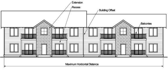
1. Building Form. All buildings shall incorporate design features such as offsets, balconies, projections, window reveals, or similar elements to preclude large expanses of uninterrupted building surfaces, as shown in the figure below. Along the vertical face of a structure, such features shall occur at a minimum of every 40 feet, on each floor, and shall contain at least two of the following features:
a. Recess (e.g., deck, patio, courtyard, entrance or similar feature) that has a minimum depth of six feet;
b. Extension (e.g., floor area, deck, patio, entrance, or similar feature) that projects a minimum of two feet and runs horizontally for a minimum length of four feet; and/or
c. Offsets or breaks in roof elevation of two feet or greater in height.
Figure 2.1.900.A. Building Form (Multi-Unit Dwelling Example)
2. Building Design and Orientation Standards.
a. Design Standards. All building elevations must provide doors, porches, balconies, terraces and/or windows for a minimum of 30 percent of each full and partial building story. A minimum of 40 percent is required for street-facing elevations located within 50 feet of a front lot line. Percent of elevation is measured as the horizontal plane (lineal feet) containing doors, porches, balconies, terraces and/or windows.
b. Orientation Standards. A minimum of one building must have an entrance facing the street or be oriented to a side yard when a direct pedestrian walkway is provided between the building entrance and the street in accordance with the standards in BDC Chapter 3.1, Lot, Parcel and Block Design, Access and Circulation. In this case, at least one entrance shall be provided not more than 30 feet from the closest sidewalk or street.
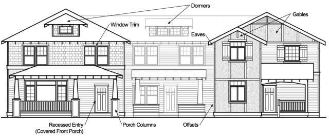
3. Detailed Design. All buildings shall provide detailed design along all elevations which are visible from the street(s) adjacent to the property (i.e., front, rear and sides). There are two options for complying with this requirement.
a. Menu Option (Type I). Detailed design shall be provided by using at least six of the following 12 architectural features on all applicable elevations, as appropriate for the proposed building type and style (may vary features on rear/side/front elevations).
These features shall be reviewed by a Type I application as per BDC 4.1.300:
Dormers
Recessed entries
Cupolas
Eaves (minimum 12-inch projection)
Bay windows
Offsets in the building face or roof by a minimum of 18 inches
Gables
Covered porch entries
Pillars or posts
Window trim (minimum four inches wide)
Balconies
Decorative patterns on the exterior finish using shingles, wainscoting, board and batt.
Figure 2.1.900.B. Examples of Architectural Details
b. Design Review Option (Type II). Detailed design shall be provided by showing compliance with the following design criteria through a Type II application and review per BDC 4.1.400, Type II and Type III Applications.
i. The general size, shape, and scale of the structure(s) are architecturally compatible with the site and with the surrounding neighborhood, unless such compatibility with existing structures does not reflect the long-term purpose or intent of the underlying zoning of the subject site.
ii. If the project includes a large structure or structures (greater than 20,000 square feet), the design shall incorporate changes in direction and divide large masses into varying heights and sizes by breaking up building sections, or by the use of such elements as variable planes, projections, bays, dormers, setbacks, canopies, awnings, parapets, changes in the roofline, materials, color, or textures.
iii. Exterior finish on vertical surfaces shall be primarily of materials such as masonry/wood siding, shingles, or stucco. The use of sheet metal or plywood shall not exceed 50 percent of the wall area. No smooth-faced cinder block construction shall be permitted on front facades. Cinder block construction for side and rear facades shall be permitted by approval as part of this review process. [Ord. NS-2487, 2023; Ord. NS-2423, 2021; Ord. NS-2353, 2019; Ord. NS-2318, 2018; Ord. NS-2271, 2016; Ord. NS-2260, 2016; Ord. NS-2016, 2006]
2.1.950Design Standards (Triplex, Quadplex, Townhome, and Single-Room Occupancy).
A. Applicability. This section’s architectural design standards apply to all of the following types of buildings:
1. Triplex.
2. Quadplex.
3. Townhome.
4. Single-room occupancy with six or fewer units.
For purposes of this section, a “street” also means a tract for mid-block developments and Tcourts.
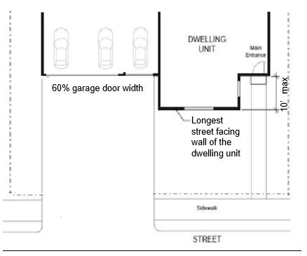
B. Garage Door Standards. The maximum combined garage door width facing the street is 50 percent of the total building width. As shown in Figure 2.1.950.B, the maximum combined garage door width facing the street may be up to 60 percent of the total building width if the front door entrance is within 10 feet of the longest street-facing wall of the dwelling unit.
1. Exemptions to Garage Door Standards.
a. Existing garages legally constructed prior to November 5, 2021.
b. When the side or rear wall of the garage faces the street, provided the standards of BDC 2.1.300(F)(1)(a) are met.
2.1.950.B.
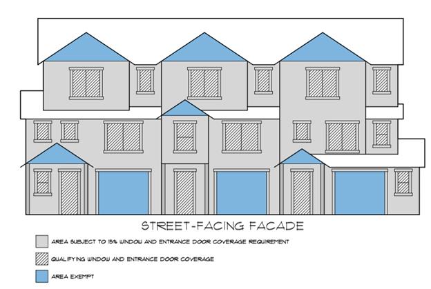
C. Front Door Orientation Standards. See BDC 2.1.1100(E), Front Door Orientation Standards.
D. Windows and Doors. A minimum of 15 percent of the area of all street facing facades must include windows and/or doors. Gabled areas and garage doors (in blue) and roofs (in white) are
Figure
not included in the base wall calculation when determining the minimum 15 percent calculation for windows/door areas.
1. Exemptions to the Windows and Doors Standards.
a. Facades separated from the front lot line by a dwelling unit;
b. Triplexes, quadplexes, townhomes and single-room occupancies created by a conversion of an existing dwelling unit.
[Ord. NS-2487, 2023; Ord. NS-2463, 2023; Ord. NS-2434, 2022; Ord. NS-2423, 2021]
2.1.1000Multi-Unit Residential Districts (RM, RH).
A. Purpose/Intent Statement. The Medium and High Density Residential Districts are intended to provide land for a mix of middle housing, multi-unit dwellings and single-room occupancies in locations that are convenient to service commercial uses and future transit opportunities.
Figure 2.1.950.D.
B. Development Standards for Multi-Unit Developments in the RM and RH Districts. In addition to the site development standards in BDC Chapter 4.2, the following standards apply to multiunit developments of five units or more and single-room occupancies with more than six units, unless otherwise stated:
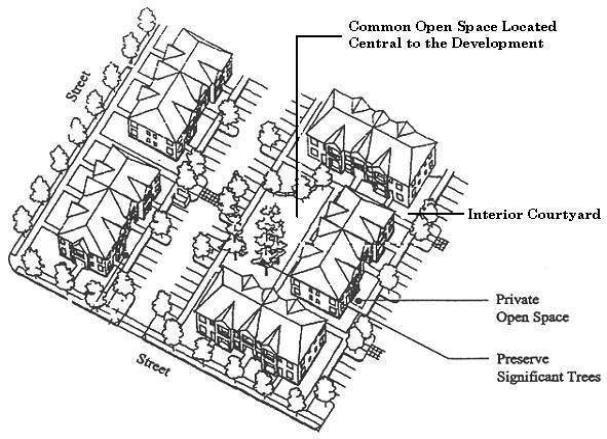
1. Common Open Space (20 Units or More). In addition to the required setback yards, a minimum of 10 percent of the site area must be designated and permanently reserved as usable common open space in all multiple-unit and single-room occupancy developments with 20 units or more, unless a credit in subsection (B)(1)(a) of this section is approved. The site area is defined as the lot or parcel on which the development is planned, after subtracting any required dedication of street right-of-way and other land for public purposes (e.g., public park or school grounds, etc.). Sensitive lands and historic buildings or landmarks open to the public and designated by the Bend Comprehensive Plan may be counted toward meeting the common open space requirements.
a. Credit for Proximity to a Park. A common open space credit of 50 percent may be granted when the development is located within one-quarter mile walking distance of a public park; and there is a direct, accessible, and maintained trail or sidewalk between the development and the park that does not cross an arterial or collector street.
2. Private Open Space. Private open space areas are required for ground-floor and upper-floor units through compliance with all of the following standards:
a. Ground-floor units must have patios or decks at least four feet deep and measuring at least 48 square feet. Ground-floor means the unit’s entrance (front or rear) is within five feet of the finished ground elevation, after grading and landscaping;
b. A minimum of 50 percent of all upper-floor units must have balconies or porches at least four feet deep and measuring at least 48 square feet. Upper-floor means units that are more than five feet above the finished grade, after grading and landscaping; and
c. Ground-floor private open space areas must not be located within 12 feet of trash receptacles.
3. Trash Receptacles. Trash receptacles must not be located within setbacks for property lines shared with single-unit detached and attached dwellings and must be screened on at least three sides with an evergreen hedge or solid fence or wall of not less than six feet in height. Receptacles must be located for easy access by trash pick-up vehicles.
C. Housing Mix Standards in the RM District. In order to ensure a mix of housing types that meets the City’s overall housing needs, in addition to minimum and maximum density standards in BDC 2.1.600, at least 50 percent of the total housing units in residential developments on any property or combination of properties between three acres and 20 acres in the RM District must be middle housing, single-room occupancy and/or multi-unit dwellings. The standards of BDC 4.5.200(E) apply to properties of 20 acres in size and greater.
Figure 2.1.1000.A. Multi-Unit Dwellings (typical site layout)
[Ord. NS-2487, 2023; Ord. NS-2463, 2023; Ord. NS-2423, 2021; Ord. NS-2303, 2018; Ord. NS2271, 2016; Ord. NS-2016, 2006]
2.1.1100Other Design Standards.
A. Development must comply with BDC 3.5.600, On-Site Drainage.
B. Development must comply with BDC 3.5.200, Outdoor Lighting Standards, and 3.5.400, Solar Standards.
C. Garage and carports must be accessed from abutting alleys. See BDC 3.1.200(E), Lot and Parcel Access, and BDC 3.1.400(F), Access Management Requirements.
D. A sink outside of a kitchen or wet bar may be added in compliance with the following:
1. In a garage or accessory structure if the space is not conditioned as defined in BDC Chapter 1.2, Definitions. A garage or accessory structure must not contain a dishwashing machine; a range hood, exhaust vent, or similar equipment; or a stove, range, or oven.
2. In a laundry room. The laundry room may include utility hook-ups for gas or electric laundry appliances. A laundry room must not contain a dishwashing machine; a range hood, or similar equipment; or a stove, range, or oven.
E. Front Door Orientation Standards
1. Applicability. This section applies to the following types of buildings:
a. Single-unit dwellings;
b. Duplex;
c. Triplex;
d. Quadplex;
e. Townhome;
f. Single-room occupancy with six or fewer units.
2. Standards. The following front door orientation standards are required for lots and parcels with frontage onto a street. For purposes of this section, a “street” also means a tract for midblock developments and T-courts. For duplexes, triplexes and quadplexes, this standard is only required to be met for one of the dwelling units. For townhome units, this standard only applies to the interior units. For single room occupancies, this standard is only required to be met for one entrance. The front door entrance must either:
a. Face the street;
b. Be at an angle of up to 45 degrees from the street;
c. Face a common open space that abuts the street and is abutted by dwellings on at least two sides; or
d. Open onto a porch. The porch must be at least 20 square feet in area and have at least one entrance facing the street or have a roof. A covered walkway or breezeway is not a porch.
3. Exemptions to Orientation Standards.
a. Duplexes, triplexes, quadplexes, townhomes and single room occupancy created by a conversion of an existing dwelling unit.
b. Dwelling units located on the flag portion of a flag lot. [Ord. NS-2487, 2023; Ord. NS-2463, 2023; Ord. NS-2462, 2023; Ord. NS-2423, 2021; Ord. NS-2389, 2020; Ord. NS-2314, 2018]
Chapter 2.4INDUSTRIAL ZONING DISTRICTS (IG, IL)
https://bend.municipal.codes/BDC/2.4.800
Sections:
2.4.100Purpose.
2.4.200Applicability and Location.
2.4.300Permitted and Conditional Uses.
2.4.400Setbacks.
2.4.500Lot Coverage.
2.4.600Building Height.
2.4.700Orientation and Architectural Design Standards.
2.4.800Special Development Standards.
2.4.100Purpose.
The Industrial Districts are intended to accommodate a range of light and heavy industrial land uses. They are intended to segregate incompatible industrial developments from other districts, while providing a high-quality environment for businesses and employees. This chapter guides the orderly development of industrial areas based on the following principles:
•Provide for efficient use of land and public facilities and services.
•Provide transportation options for employees and customers.
•Locate business services close to major employment centers.
•Ensure compatibility between industrial uses and nearby commercial and residential areas.
•Provide appropriate design standards to accommodate a range of industrial users, in conformance with the Bend Comprehensive Plan.
•Conserve industrial zoned lands for industrial uses. [Ord. NS-2271, 2016; Ord. NS-2195, 2013; Ord. NS-2016, 2006]
2.4.200Applicability and Location.
This chapter applies to all development in the General Industrial District (IG) and Light Industrial District (IL). The Industrial Districts are identified on the City’s official Zoning Map. The districts serve distinctly different uses as described below.
Zone District
General Industrial
Light Industrial
Location and Characteristics
This zone is intended to provide for the establishment of light and heavier industrial uses essential to the development of a balanced economic base in an industrial environment with a minimum conflict between industrial uses and nonindustrial uses.
This zone is intended to provide for heavier commercial and light industrial uses with easy access to collector and arterial streets.
[Ord. NS-2195, 2013; Ord. NS-2016, 2006]
2.4.300Permitted and Conditional Uses.
A. Permitted and Conditional Uses. The land uses listed in Table 2.4.300 are permitted in each of the applicable districts, subject to the provisions of this chapter. Only land uses that are specifically listed in Table 2.4.300, and land uses that are approved as “similar” to those in Table 2.4.300 through a development approval are allowed.
B. Existing Uses. Office uses within an office building lawfully established within an Industrial Zone under previously effective land use regulations are a permitted use. Expansion or enlargement of 25 percent or less of such office uses or structures that are nonindustrial shall be subject to the provisions of BDC Chapter 4.2, Site Plan Review and Design Review. For expansion or enlargement greater than 25 percent, Conditional Use Permit approval is also required. Conditions of prior approval shall continue to apply unless modified in conformance with BDC 4.1.1325, Modification of Approval.
Table 2.4.300 – Permitted and Conditional Uses
Land Use IG IL
Industrial
Light manufacturing, fabrication and repair (e.g., appliances, electronic equipment, printing, furniture, signs and similar goods) with incidental sales associated with a permitted use.
Heavy manufacturing, assembly, and processing of raw materials and recycling
yards, automobile wrecking yards, and similar uses
and development facilities
processing uses (e.g., dry cleaning, laundry)
and beverage processing and packaging
grow sites and marijuana producing
*Marijuana wholesale
*Marijuana processing of cannabinoid concentrates and cannabinoid products
*Marijuana processing of cannabinoid extracts
Residential
One caretaker unit shall be permitted for each development
Note: Other residential uses are not permitted; however, residences existing prior to the effective date of the ordinance codified in this code may continue subject to the standards in BDC Chapter 5.2, Nonconforming Uses and Developments.
Commercial
Vehicle, equipment and boat repair, rental, storage, service
Industrial service (e.g., cleaning, repair)
Medical and dental laboratories and veterinary clinics
Outdoor commercial uses (e.g., outdoor storage, building and garden supply)
Small-scale personal and professional services
• up to 2,500 square feet of gross floor area (e.g., coffee shop/deli, dry cleaners, barber shops and salons, copy center, banks, and financial institutions and similar uses)*
• No limit to size (child care and similar uses)*
testing, research and development facilities
Public and Institutional
Government facilities where the public is generally not received (e.g., public safety, utilities, school district bus facilities, public works yards, transit and transportation, and similar facilities)
*Utilities (above ground)
Special district facilities (e.g., irrigation district, and similar facilities)
and trade schools
Public park and recreation facility
hub
Miscellaneous Uses
*Shelters N P
*Small hydroelectric facility P P
Wireless and broadcast communication facilities See BDC Chapter 3.7
Key to Districts:
IG = General Industrial District
IL = Light Industrial District
Key to Permitted Uses
P = Permitted
N = Not Permitted
C = Conditional Use
*Special standards in conformance with BDC Chapter 3.6, Special Standards for Certain Uses, and BDC 2.4.800, Special Development Standards.
[Ord. NS-2463, 2023; Ord. NS-2443, 2022; Ord. NS-2303, 2018; Ord. NS-2289, 2017; Ord. NS2264, 2016; Ord. NS-2256, 2015; Ord. NS-2195, 2013; Ord. NS-2158, 2011; Ord. NS-2016, 2006]
2.4.400Setbacks.
Setbacks provide separation between industrial and nonindustrial uses for fire protection/security, building maintenance, sunlight and air circulation, noise buffering, and visual separation. All developments shall meet applicable fire and building code standards, which may require greater setbacks than those listed in this section (e.g., for combustible materials, etc.).
A. Front Yard Setbacks.
1. General Industrial District. The minimum front yard setback is 10 feet.
2. Light Industrial District. The minimum front yard setback is 10 feet.
3. Exceptions.
a. Other special setbacks in conformance with BDC 3.4.200(J), Special Setbacks, may apply.
B. Rear Yard Setbacks. There is no required rear yard setback in the IG or IL Industrial Districts, except when development is abutting a Residential Zone. In this situation, no building or structure shall be constructed less than 20 feet from the Residential District. Portions of buildings or structures that exceed 35 feet in height shall be set back an additional one-half foot for each foot by which the building height exceeds 35 feet.
C. Side Yard Setbacks. There are no required side yard setbacks in the IG or IL Industrial Districts, except when development is abutting a Residential Zone. In this situation, no building
or structure shall be constructed less than 20 feet from the Residential District. Portions of buildings or structures that exceed 35 feet in height shall be set back an additional one-half foot for each foot by which the building height exceeds 35 feet.
Table 2.4.400
Setback
Minimum Front Yard
Minimum Rear Yard* 0 feet / 20 feet (see BDC 2.4.400) 0 feet / 20 feet (see BDC 2.4.400)
Minimum Side Yard*
/ 20 feet (see BDC 2.4.400)
/ 20 feet (see BDC 2.4.400)
*These standards are supplemented by the provisions of this section.
**Subject to the provisions of BDC 2.4.600, Building Height.
[Ord. NS-2195, 2013; Ord. NS-2016, 2006]
2.4.500Lot Coverage.
The maximum allowed lot coverage in the General Industrial and Light Industrial Districts is 80 percent. The maximum allowed lot coverage is computed by calculating the total area covered by buildings including accessory structures, and comparing this figure with the total area of the development site. Compliance with other sections of this code may preclude development of the maximum lot coverage for some land uses. [Ord. NS-2195, 2013; Ord. NS-2016, 2006]
2.4.600Building Height.
The following building height standards are intended to promote land use compatibility and flexibility for industrial development at an appropriate community scale:
A. Base Requirement.
1. Buildings and structures in the General Industrial and Light Industrial Districts shall be no more than 50 feet in height and shall comply with the building setback standards in BDC 2.4.400.
B. Exceptions. The height may be increased over the base height if approved through a Conditional Use Permit when one or more of the following mitigation methods are applied:
•Additional setbacks;
•Stepping down of building elevations;
•Visual buffering, screening; and/or
•Other appropriate measures to provide a height transition between industrial development and adjacent nonindustrial development. [Ord. NS-2195, 2013; Ord. NS-2016, 2006]
2.4.700Orientation and Architectural Design Standards.
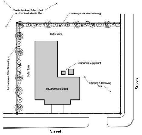
A. Industrial Development Orientation. All industrial developments shall be oriented on the site to minimize off-site adverse impacts of noise, glare, smoke, dust, exhaust, vibration, etc., and protect the privacy of adjacent Nonindustrial Zones to the extent practicable. The following standards apply to all development in the Industrial Districts when abutting nonindustrial zoning districts.
1. Equipment Standard. Mechanical equipment, lights, emissions, shipping/receiving areas, and other components of an industrial use that are outside of an enclosed building shall be located away from abutting Residential Zones, schools, parks and other nonindustrial zoned areas as practicable;
2. Buffering Standard. The City may require a landscape buffer of a specific width, or other visual and/or sound barrier (fence, wall, landscaping, or combination of such measures), to mitigate adverse impacts that cannot be avoided through building orientation standards alone. For additional buffering standards see BDC 2.4.800(C).
Figure 2.4.700 – Industrial Development Orientation
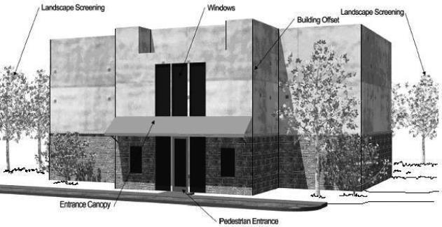
B. Architectural Standards. All developments in the Industrial Districts shall be evaluated during site plan review for conformance with the following standards:
1. Building Mass. Where building elevations are oriented to the street, architectural features such as windows, pedestrian entrances, building offsets, projections, detailing, change in materials or similar features shall be used to break up large building facades and walls that are longer than 75 linear feet. A minimum of 15 percent of the horizontal building facade shall contain a variety of architectural features.
The horizontal building elevation facing an arterial or collector street shall provide a variety of the architectural features described above for a minimum of 30 percent of the horizontal building facade.
Figure 2.4.700.B. Architectural Features (Typical)
Note: Figure above is intended to illustrate typical building design elements, and should not be interpreted as a required architectural style. [Ord. NS-2195, 2013; Ord. NS-2016, 2006]
2.4.800Special Development Standards.
The Industrial Districts accommodate a range of manufacturing, industrial office uses, and small personal service commercial uses.
A. Small-Scale Personal and Professional Services. Small-scale personal and professional services and incidental sales uses as specified in Table 2.4.300 shall comply with the following development standards:
1. Small-scale personal service commercial uses may be allowed when accessory to a primary user of the industrial development (in the case of a large industrial area). No more than 10 percent or 2,500 square feet (whichever is greater) of a permitted or conditionally allowed industrial development may be occupied by an accessory commercial use, unless otherwise approved through a Conditional Use Permit.
2. Primary use, small-scale personal and professional and incidental sale uses may occur as stand-alone businesses when the total gross floor area of each use does not exceed 2,500 square feet. For multiple uses, where the uses share one building, the total building area shall not exceed 5,000 square feet. A single use may occupy 5,000 square feet if approved through a Conditional Use Permit. These nonindustrial use buildings shall comply with the provisions of BDC 2.2.600, Commercial Design Review Standards.
B. Location Standards. Child care centers and other similar uses shall be limited to properties located at the perimeter of the Industrial Districts with frontage on arterial or collector streets, unless they are accessory to a primary permitted use. When these uses occur as a stand-alone building, the provisions of BDC 2.2.600, Commercial Design Review Standards, apply.
C. Buffering. A buffer with a minimum width of 20 feet is required between industrial development and any adjacent Residential Zoning District. The buffer shall provide landscaping to screen the industrial activities, such as parking, service and delivery areas, from the Residential Districts. The buffer shall not contain trash receptacles or be used for the storage of equipment, materials, vehicles, etc.
D. Prohibited Uses. Retail medical marijuana dispensaries and marijuana recreational facilities. [Ord. NS-2256, 2015; Ord. NS-2195, 2013; Ord. NS-2016, 2006]