Authors:
Ibtsam Saeed
Safiya Raheman
Wasila Parvez
Zainab Chaudhry
Mentors:
Dr. Maram Altawil
Canan Çelik
Veronica Garcia Donoso
Javier Prieto
Studio: Integrated Project - III
BRIDGING POLYCENTRIC HUBS ALONG RHINE-ALPINE
1 Collaborate | Co-create | Connect
WiSe 2022 - 2023
A report on Title drafted for Integrated Project- III Studio for M.Sc. Transforming City Regions at RWTH Aachen University.
Winter Semester 2022-23
Collaborate | Co-create | Connect 2 Collaborate | Co-create | Connect
ABSTRACT
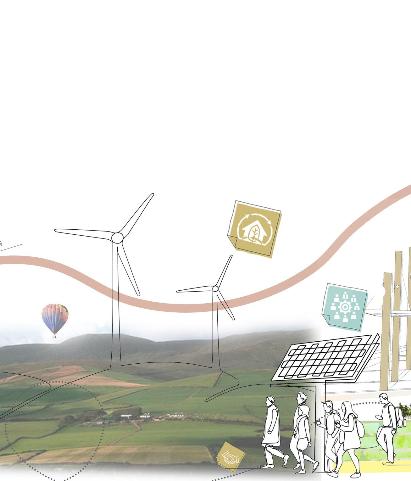
The Corridor Rhine-Alpine is a project to improve rail freight transportation in Europe and to encourage modal shift from road to rail. By filling the missing gaps and introducing the intelligent infrastructure on the train lines and roads we are enhancing the interoperability and reducing the travel time of commuters and connecting smaller towns along the bigger cities. By creating small scale business and innovation districts in these smaller towns we plan to promote small business owners to collaborate with big institutions. By connecting these new small-scale business and innovation districts with Main Central Hubs on either side of the border to create an urban system and collaboration on a national level. By providing areas for energy and productive research landscapes we aim to connect the locals and researchers where they can co-create with the existing. In this way, polycentric development can contribute to reducing regional disparities at all levels. This avoids further excessive economic and demographic concentration within the core areas at EU and national scales and revitalizes less densely settled and economically weaker regions. In the long run, polycentric development contributes to making cities and regions more resilient and diversified, which strengthens the competitiveness of Europe in the global economy.
Collaborate | Co-create | Connect 3 Collaborate | Co-create | Connect
1. About
1.1. Introduction
CONTENTS
1.1.1. Rhine-Alpine Corridor
1.1.2. Aims and Objectives
2. Methodology
2.1. Course of Project
2.2. Research/Design Questions
3. Site Analysis
3.1. Mobility
3.1.1. Railway Network
3.1.2. Road Network
3.1.3. IWW Network
3.1.4. Train Systems
3.2. Energy
3.2.1. Non-Renewable & CO2
3.2.2. Renewable Energy Plants
3.2.3. Electrification Systems
3.3. Economy
3.3.1. GDP
3.3.2. Labor Market Clusters
3.4. Education
3.4.1. University Collaborations
3.5. SWOT
4. Vision
4.1. Polycentric Urban Systems
4.1.1. Focus Areas
4.1.2. Polycentric hubs & Approaches
4.1.3. Stakeholders
5. Design Interventions
5.1. Rhine-Alpine Corridor
5.1.1. Concept Maps
5.1.2. Strategies
5.1.3. Master Plan
5.2. PAMINA
5.2.1. Regional Analysis
5.2.2. Concept Maps
5.2.3. Regional Master Plan
6. Conclusion: Time line
7. References
Collaborate | Co-create | Connect 4 Collaborate | Co-create | Connect
Collaborate | Co-create | Connect 5 Collaborate | Co-create | Connect
ABOUT
CHAPTER - 1
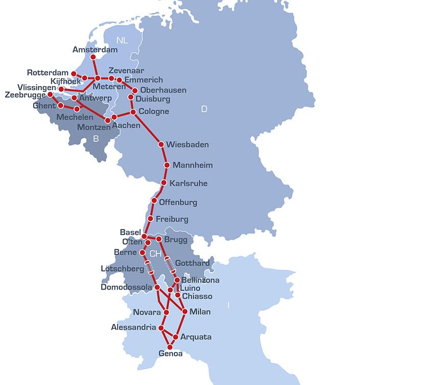
1.1.1. Introduction: Rhine-Alpine Corridor
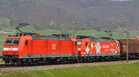
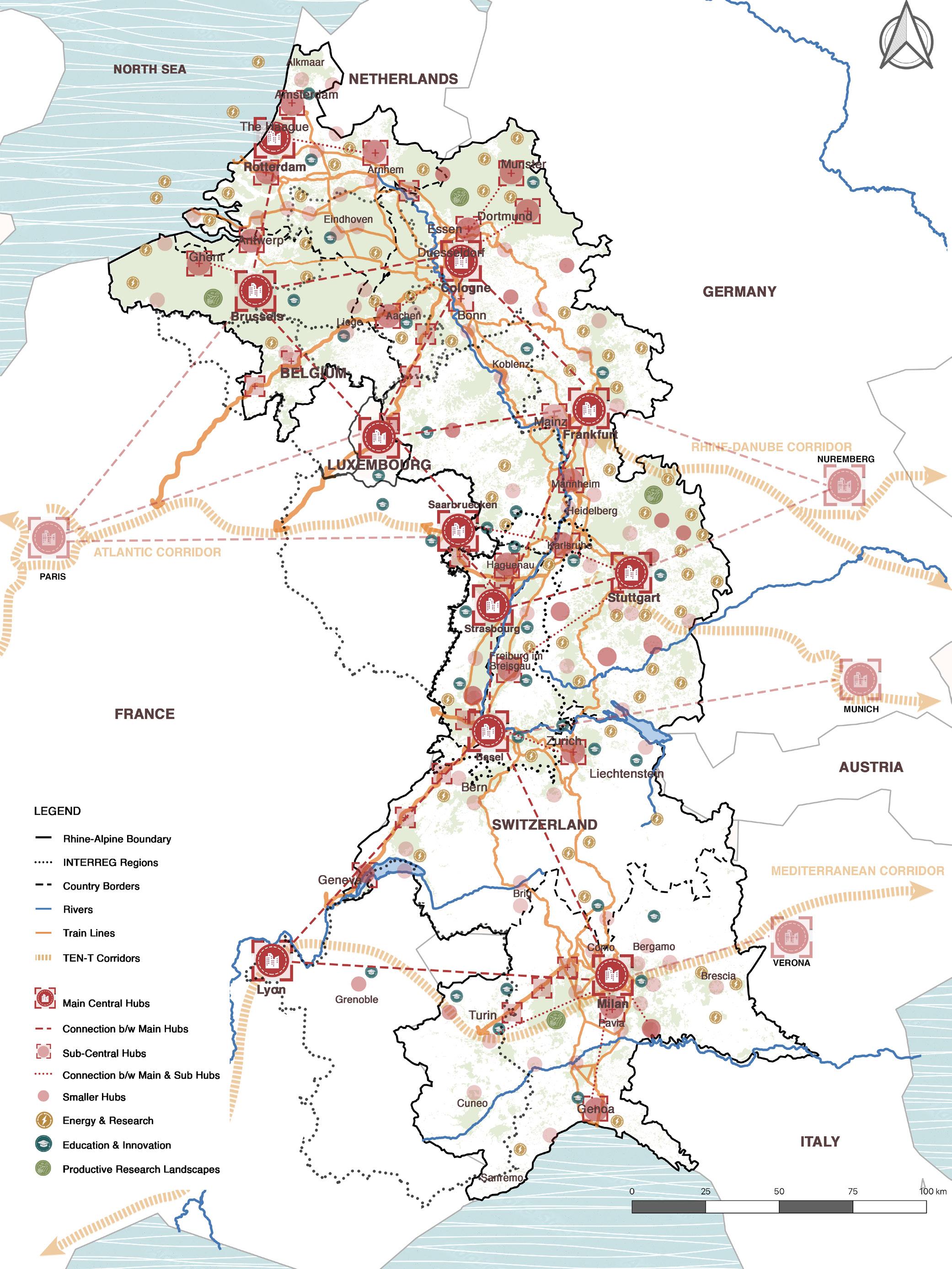
The Corridor Rhine-Alpine is a project to improve rail freight transportation in Europe and to encourage modal shift from road to rail. The Rhine Alpine is located in the “Blue Banana”, the region which is known as the most densely populated and strongest region in Europe. The most significant economic centers are located on the corridor, such as Brussels and Antwerp in Belgium, the Randstad region in the Netherlands, the German Rhine-Ruhr and Rhine-Neckar regions, the Basel and Zürich regions in Switzerland and the Milan and Genova regions in Northern Italy. This multi-modal corridor constitutes one of the busiest freight routes in Europe. It goes over five EU Member States (Belgium, Netherlands, Germany, France, Italy) and Switzerland. There are five more corridors that overlap with the corridor, the North Sea-Baltic, North Sea-Mediterranean, Rhine-Danube, Atlantic, and Mediterranean corridors. The corridor includes all modes of
transport over a total length of about 6,200 km. With about 3,000 km rail is the backbone of the Corridor. Road accounts for about 1,500 km. Inland Waterways (IWW) accounts for about 1,700 km2, including the Rhine River as an important route. The Corridor includes 8 seaports and 22 inland ports, 13 airports, 72 core inter-modal terminals and 13 core urban nodes. To allow for a seamless connectivity throughout Europe until 2030, some critical issues have to be addressed such as rail capacity bottlenecks, road congestion, noise and pollution in urban areas, incomplete ERTMS deployment, reliable and efficient navigability on the Rhine River, upgrades of lock capacity, cross border operations and vast maintenance issues of existing infrastructure.
Collaborate | Co-create | Connect 6 Collaborate | Co-create | Connect
Image Rhine Alpine Corridor EU
1.1.2. Introduction: Aims and Objectives
In 2010, the EU Regulation 913/2010 regarding a European rail network for competitive freight was picked by the European Parliament and the Council and realized on 9 November 2010. The main purpose was to increase rail freight’s attractiveness and efficiency with particular focus on international traffic, so that rail can increase its competitiveness and market share on the European transport market. The main aims of the Rhine Alpine corridor have been laid out as follows:
• Territorial and Structural cohesion: the Core network must ensure accessibility and connectivity of all regions of the EU.
• Transport sustainability: all transport modes must be developed in view of addressing concerns regarding sustainability and economic efficiency.
• Multi-modality: interconnection of transport modes at the nodes and real-time information in the transport chain.
• Increase in the benefits for the users: the European transport network must answer to the mobility and transport needs of its users.
• Road transport: reduction of congestion, interoperability on the network, safety, availability of clean fuels, reduction of emissions etc.
• Efficiency between different networks: the removal of bottlenecks, the increase in capacity of over utilized sections and bridging of missing links within the member states’ territories and between them must be a priority for the European network.
• Railway transport: ERTMS-equipped infrastructure, interoperability of national networks, full electrification, safety, multimodal nodes connected to rail etc.
The creation of a Single European Transport Area should ease the movements of citizens and freight, reduce costs and enhance the sustainability of European transport.
Collaborate | Co-create | Connect 7 Collaborate | Co-create | Connect
Image Rhine Alpine Corridor EU
CHAPTER - 2 METHODOLOGY
Collaborate | Co-create | Connect 8 Collaborate | Co-create | Connect
2.1. Course of Project
The project development was conducted through a series of phases. First phase of any project is to look for inspiration, and our primary source was literature on studies on polycentric urban regions. Cities in polycentric urban regions share ambiguous relations with each other: they are potential partners in strengthening the external profile of their region as whole vis-a-vis other regions. ‘Polycentric urban regions’ (PURs) have become a key concept in regional studies both as an analytical framework to capture empirical realities as well as part of normative visions and goals in regional development policies. Internationally, this was reinforced in the New Urban Agenda by a commitment to ‘support the implementation of integrated, polycentric and balanced territorial development policies and plans, encouraging cooperation and mutual support among different scales of cities and human settlements’ (UN-Habitat, 2016, p. 24).
In the next phase, a site analysis was conducted to highlight the main problems on the Rhine Alpine corridor. The key problems were categorized in accordance with four aspects; Mobility, Energy and Research, Economy, and Education. This categorization was used in line with the concept of polycentric urban systems to formulate design strategies. The concept is enriched through the ideology of Collaborating, Co-creating and Connecting the countries across the Rhine Alpine Corridor. The strategies were developed firstly on the Rhine Alpine scale, and then on the PAMINA region scale. The PAMINA region was selected as the focus area for its obvious potential. Moreover, a stakeholder analysis was conducted to identify the potential partners who would invest in the project. Lastly, a time line was proposed divided into three phases, that projects the estimated duration of strategies categorically.
Collaborate | Co-create | Connect 9 Collaborate | Co-create | Connect
Graphics: Authors.
Collaborate | Co-create | Connect 10 Collaborate | Co-create | Connect
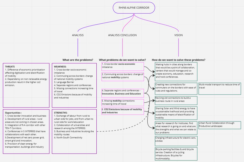
2.2. Research/Design Questions
The research/design questions have been formulated on two scales - Rhine-Alpine and PAMINA.
Rhine-Alpine
Analysis:
What is the need of this project? What problems are there?
Inference of Analysis: What problems do we want to solve? (sorted by the hierarchy of importance)
Vision:
How do we want to solve these problems? How does this situation affect the stakeholders?
PAMINA
Why are we trying to solve these problems in Rhine Alpine specifically for PAMINA region, what makes it special?
How do we implement our solutions in RhineAlpine in PAMINA Region? (strategies are sorted by importance)
Who are the stakeholders here and how does it directly affect them?
Collaborate | Co-create | Connect 11 Collaborate | Co-create | Connect
CHAPTER - 3 SITE ANALYSIS
Collaborate | Co-create | Connect 12 Collaborate | Co-create | Connect
3.1.1. Mobility: Railway Network
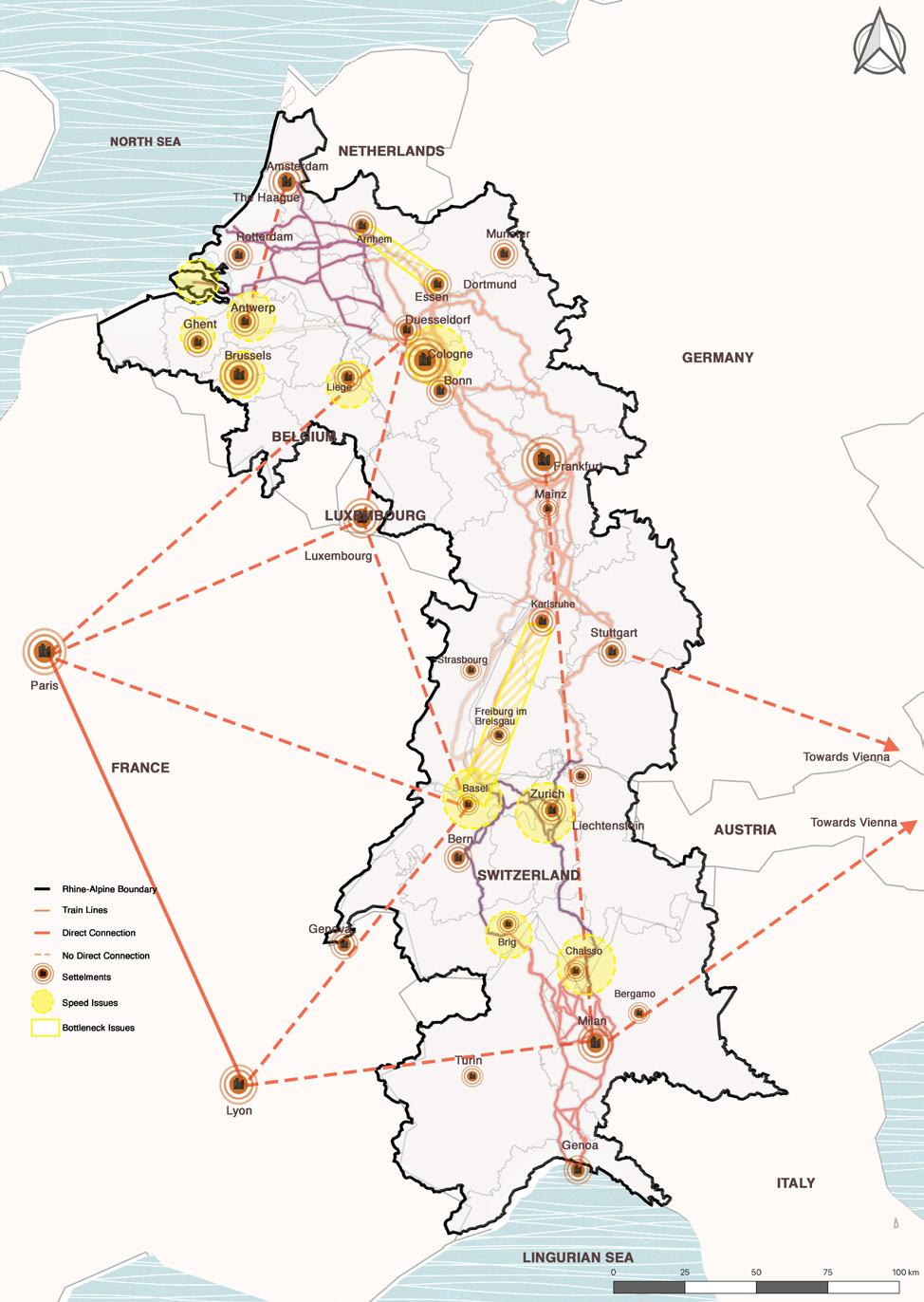
Graphics: Authors. Data: Rapp Trans
3.1.2. Mobility: Road Network
The total railway length along the RhineAlpine corridor is 3000 km and serves as the backbone of the corridor. Germany shares the largest network of railway lines. Total length share of the rail network in the corridor is 49% and almost 24.1% of corridor freight volume is transported via rail. As the railway network has the largest share of the network in the corridor it also has more issues compared to the other networks. Although the railway network is connected from Genoa to Amsterdam it has number of issues which include: Interoperability issues, Capacity and congestion issues, Electrification and upgradation of the train lines and Delays and missing links. Due to these problems, cross border rail travel is a big issue in the entire corridor. The image shows the sections where the rail network has main issues. The line from Basel to Karlsruhe forms the longest section which is under stress due to the issues mentioned above. Therefore the rail network needs extra attention for the smooth functioning of the corridor.
The Road network of Rhine Alpine corridor has a total length of 1,721 Km and almost all of the road network fulfills the standards of TEN-T ( all the sections are categorized as Highways) but there are some sections on the Road network where the traffic congestions and bottlenecks are still the problem. It is also important to note that the total share of the road network in the Rhine-Alpine corridor is almost 34% and the total share of freight transport via road network is 25.1%. These bottlenecks occur mostly near the urban nodes and the bigger cities due to local traffic and mixed transit during the peak hours. The Main reasons for the bottlenecks in the road network are deteriorating conditions of infrastructure and missing links at some parts. The analyzed map shows the choke points on the road network which are suffering due to the bottleneck issues.
Graphics: Authors. Data: Rapp Trans
Collaborate | Co-create | Connect 13 Collaborate | Co-create | Connect
3.1.3. Mobility: IWW Network
The Rhine alpine corridor incorporates the Rhine River as the key inland waterway in Europe.The IWW network of the corridor is very well established which includes 7 major ports and various inland ports. The main ports are located in the North in Netherlands and Belgium like the Ports of Amsterdam, The Hague and Antwerp and in the south there is one main Port in Genoa. The total length share of the IWW network in the corridor is only 25% but almost 58% of the total cross border freight is transported via inland waterways. In the IWW network of the corridor the main issue is the achievement of the minimum Draught of 2.5 meters all year around, apart from that there are some congestion issues in the ports of Rotterdam and Antwerp. Apart from that the sections on the River Nektar and Moselle form bottleneck issues due to the high traffic of large Barges. Other than this all the main ports and inland ports are fully connected to the rail and road network.
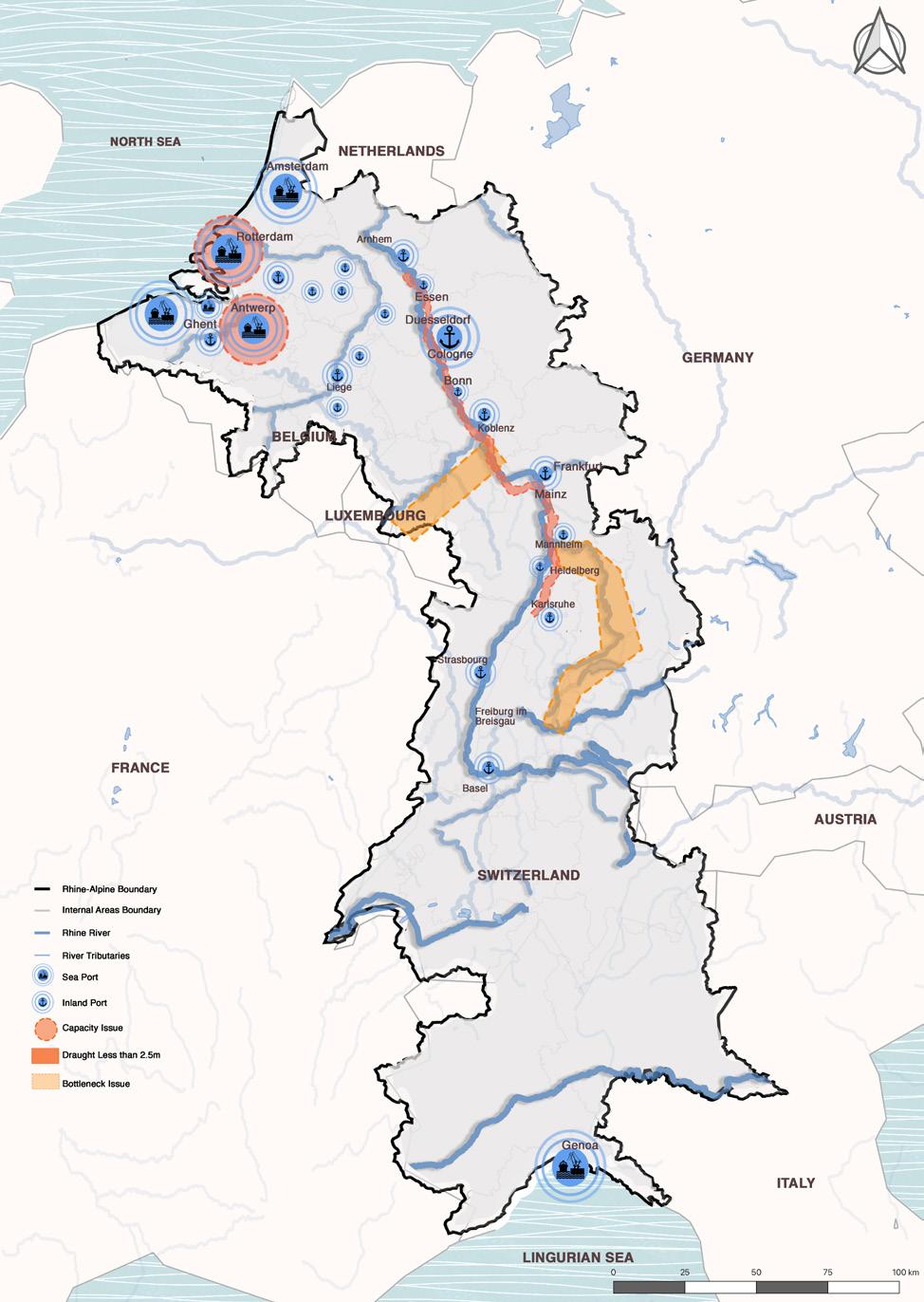
Graphics: Authors. Data: Urbantoolbox.it
3.1.4. Mobility: Train Systems
Train interoperability is a big problem in the entire Rhine Alpine corridor despite it being the most mature corridor of the TEN-T. The main reason for this interoperability issue is the difference in the electrification system and Train Operating systems. Each country has their own standards and systems and due to the availability of these different systems the interoperability is a huge deal. Due to this Border crossing is also affected and it also causes unexpected delays in the travel time. According to Trackopedia the following train control systems are under operation in the countries which are part of the Rhine-Alpine Corridor.
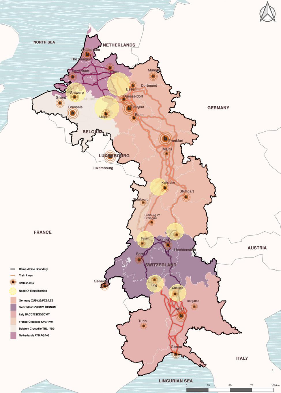
Germany: ZUB122/PZB/LZB
France: Crocodile KVB/TVM
Italy: BACC/BSDD/SCMT
Netherlands: ATB AG/NG
Switzerland: ZUB121 SIGNUM
Belgium: Crocodile TBL 1/2/3
Luxembourg: Crocodile MEMOR II
Graphics: Authors. Data: Trackopedia
Therefore, it is important to have a common system for seamless travel via rail.
Collaborate | Co-create | Connect 14 Collaborate | Co-create | Connect
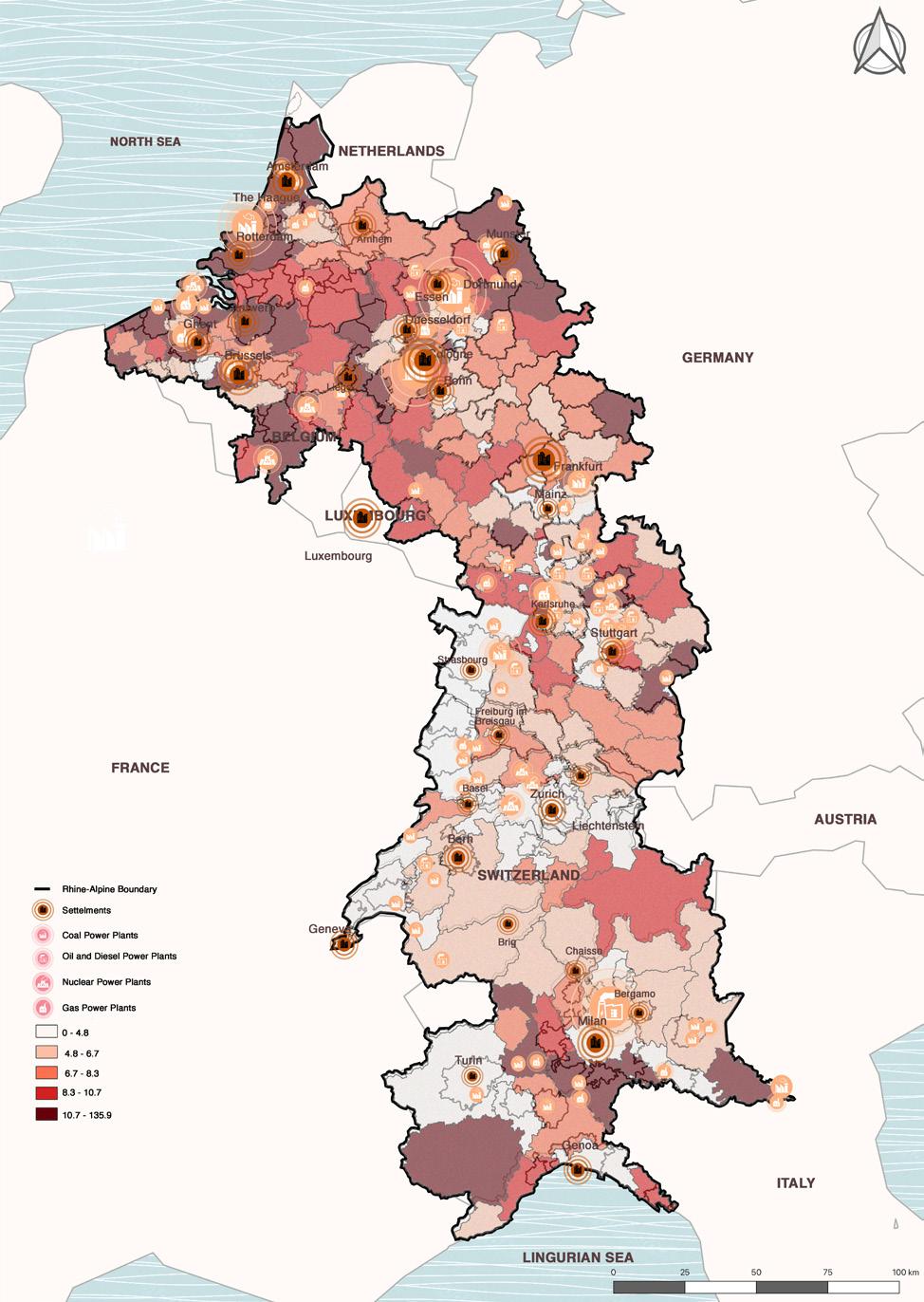
3.2.1. Energy: Non-Renewable & CO2
There are a number of non-renewable energy plants across the Rhine-Alpine corridor. These include the coal power plants, oil and diesel power plants, nuclear power plants and gas power plants. In the map, we observe how regions with more non-renewable energy plants as their source of energy are contributing towards higher levels of CO2 emissions. These regions include cities such as Karlsruhe, Stuttgart on the German border, Brussels and Antwerp on the Belgium border. Regions with less non-renewable energy reliance have lower CO2 emissions, these include cities such as Strasbourg on the French border and Zurich on the Switzerland border.
Graphics: Authors. Data: openghgmap.ne, OSM
3.2.2. Energy: Renewable Energy Plants
There are a number of renewable energy plants across the Rhine-Alpine corridor. These include wind power plants, hydrogen facilities, solar power plants and biomass plants. The map also indicates the regions with the most farmland area. The areas in German and Netherlands have the most amount renewable energy plants, as observed on the map. Areas in Switzerland and Italy show the least amount of renewable energy plants. The overlap of farmlands shows the potential areas which can be used for sustainable means of energy sources and production and research.
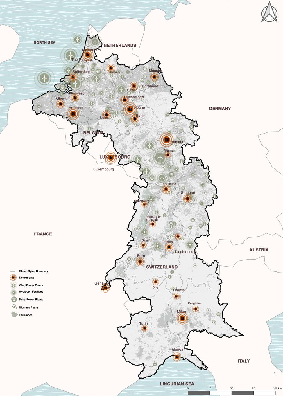
Graphics: Authors. Data: Global Climate Protection Map klimateschutzkarte.de, OSM
Collaborate | Co-create | Connect 15 Collaborate | Co-create | Connect
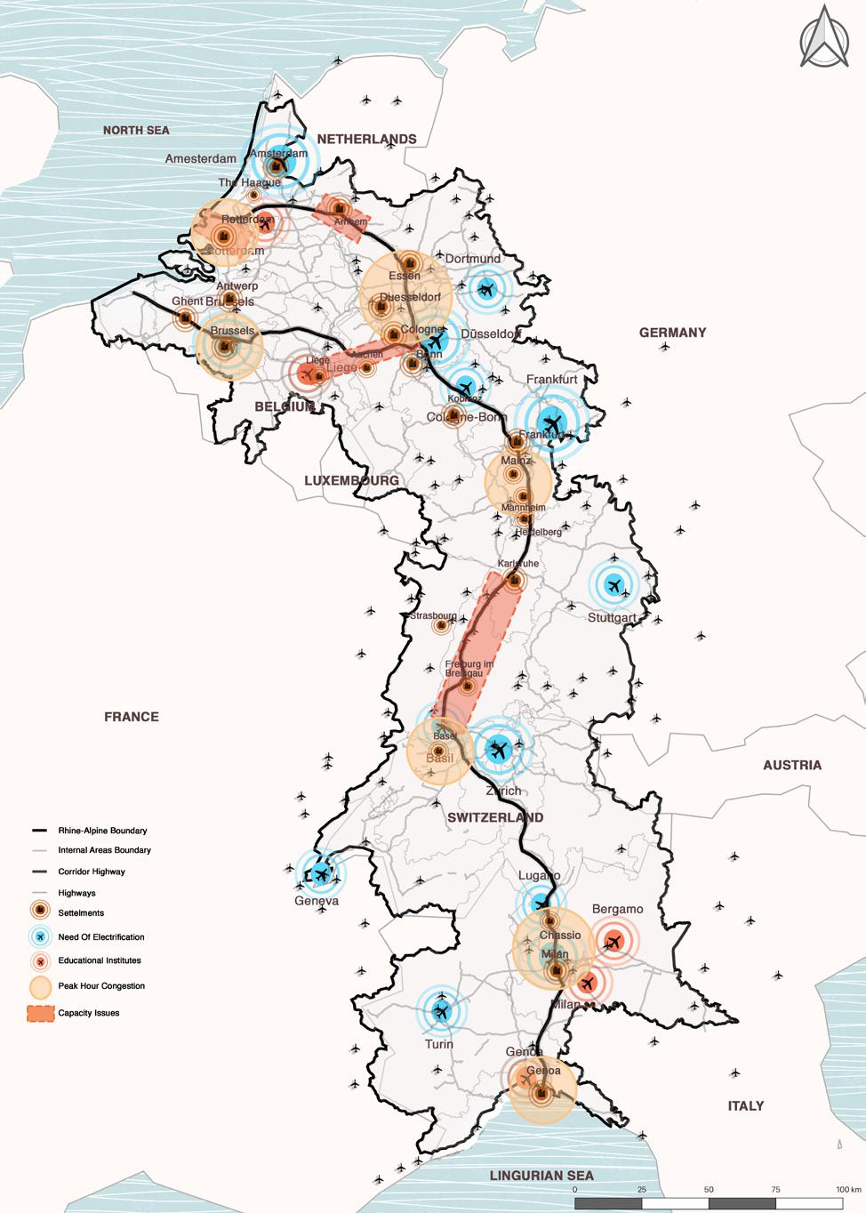
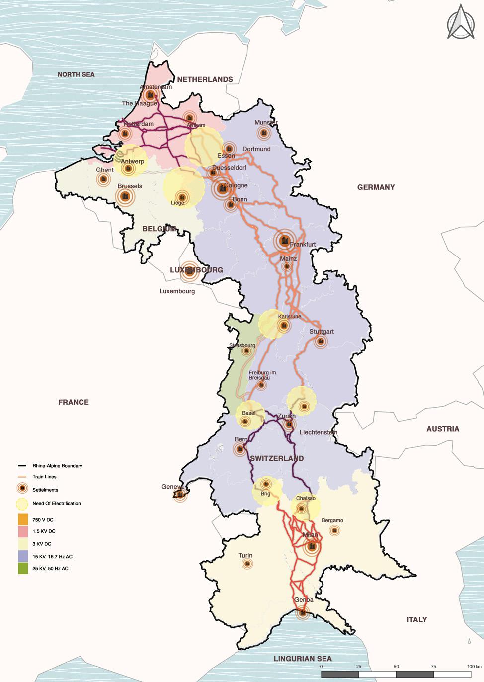
3.2.3. Energy: Electrification Systems
The European Commission has decided to make 2021 the European Year of Rail. The idea is motivated by the goal of a climateneutral European Union (EU) by 2050. As an environmentally friendly transport mode, rail has the opportunity to play a particular role in helping cut transport emissions. Rail accounts for only 2 percent of total EU energy consumption in transport. But so far, the required modal shift to rail has not been achieved, but cross-border rail transport in particular has a great potential in the long run. Apart from using different rail operating systems each country also has different electrification of lines - which is another hurdle in cross border rail crossing.
Germany and switzerland use 15 Kv Ac (kilo volt Alternative current)
Italy uses mixed 3 Kv Dc (Kilo volt Direct current) and 25 Kv Ac
France and Netherlands use 1500 v Dc
Graphics: Authors. Data: Heinrich Boell Stiftung EU
3.3.1. Economy: GDP
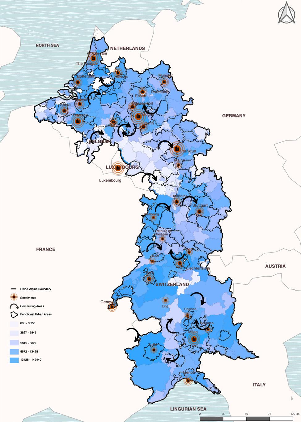
The regions of Rhine-Alpine corridor is counted among the most densely populated region. A Functional Urban Area consists of a densely inhabited city and of a surrounding area (commuting zone) whose labor market is highly integrated with the city (OECD 2012).
Functional urban areas of the Rhine-Alpine region are the key factor of the region’s economic development and population growth. Most of the regions experiencing growth have a high GDP, while regions with a rapid population decline have a lower GDP in comparison. In turn, regions with low income and rapid population change face the most challenging situation.
Graphics: Authors. Data: OECD, Eurostat
Collaborate | Co-create | Connect 16 Collaborate | Co-create | Connect
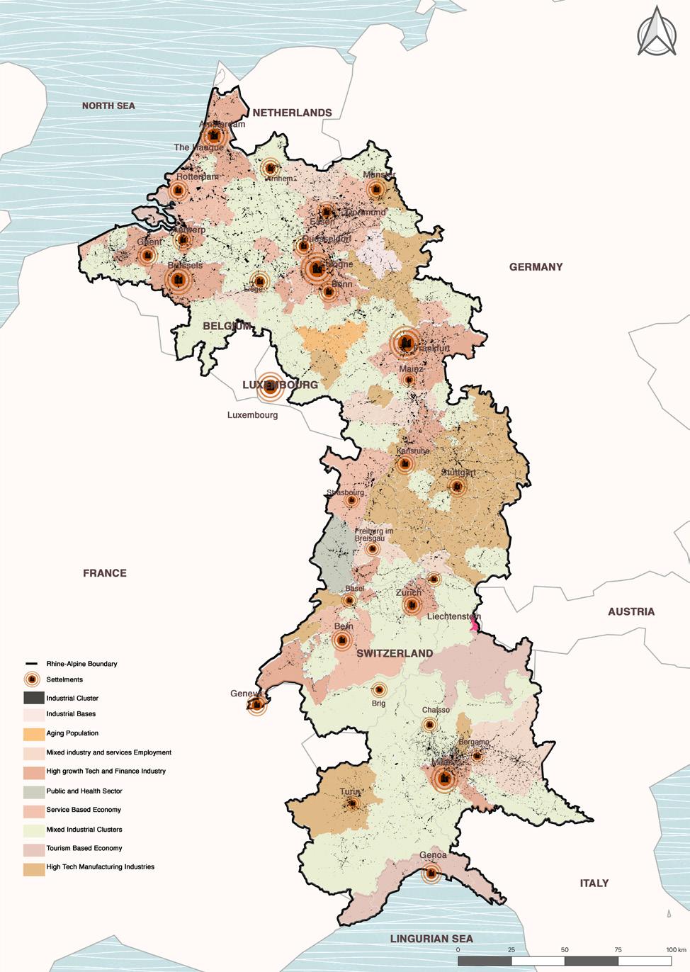
3.3.2. Economy: Labor Market Clusters
The labor market where a person resides has the most significance to them. The local economies vary to the point that they are different within different cities of a country. The map shows locations within each of the resulting clusters share common aspects in industrial bases, aging population, mixed industry and services employment, high growth tech and finance industry, service based economy, mixed industrial clusters, tourism based economy, and high tech manufacturing industries. These clusters are grouped into three assortments: dynamic growth hubs, stable economies and shrinking regions. This in turn visualizes the differences between local economies currently across the Rhine-alpine corridor.
Graphics: Authors. Data: McKinsey & Company
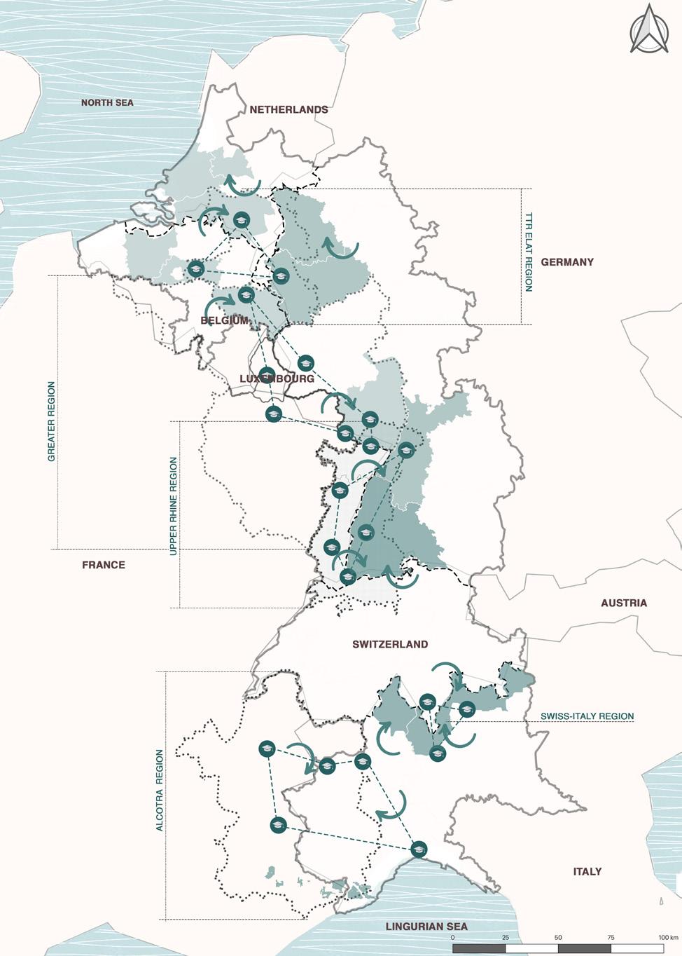
3.4.1. Education: University Collaborations
Graphics: Authors. Data: Mission Operational Transfrontliers
Various INTERREG regions were identified that have conferences and discussions within themselves and also house some of the major EGTCs and Eurodistricts. TTR ELAT Region in the north that includes the cross-border regions of NL, BE and Geraldo-Eindhoven, Leuven and Aachen where various Technological and Educational projects are in discussion and process. Greater Region that includes the cross-border regions of NL, BE, LU and DE. It is a region of major crossborder commuting for work, education and research. Upper-Rhine Region includes the section of the Rhine between Basel in CH and Bingen in DE along with the Alsace region in FR. This region holds its own conferences to delegate responsibilities in different sectors and focus areas like Education and Innovation, Vocational Training, SocioEconomy, Foreign Affairs etc. Alcotra Region covers the Alpine territory between FR and IT. It works on various themes within the region such as Applied Innovation, Better controlled environment, Attractiveness of the Territory, Social Inclusion and European citizenship
Collaborate | Co-create | Connect 17 Collaborate | Co-create | Connect
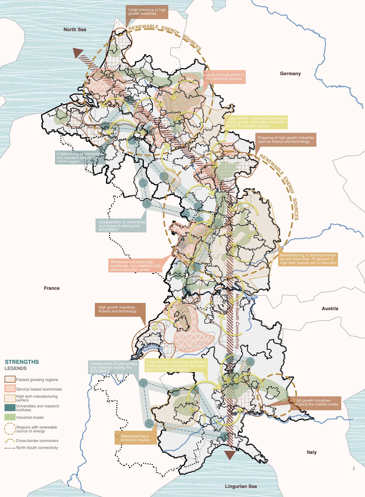
3.5. SWOT: Strengths
The strengths of the Rhine-Alpine corridor are various: there’s a large presence of high growth industries. These include industries of finance and technology. Manufacturing is one of the dominant industries and more than 70 percent of the high tech regions are in Germany. There are a number of educational collaborations going on among different regions such as the TIARA region and INTERREG. The cross border commuting is one of the key strengths of the corridor, which boosts economic growth, integration and
cohesion in EU border regions. The wholesale and retail trade workforces have relatively high tertiary education levels. There’s a share of employment in non-technical services. Moreover, there are a number of renewable energy sources spread across the corridor. There’s an exchange of labor from rural to urban side for jobs, and from urban to rural side for work/education. A number of business and industries lie along the mobility routes. There’s a strong North-South connectivity.
Collaborate | Co-create | Connect 18 Collaborate | Co-create | Connect
Graphics: Authors.
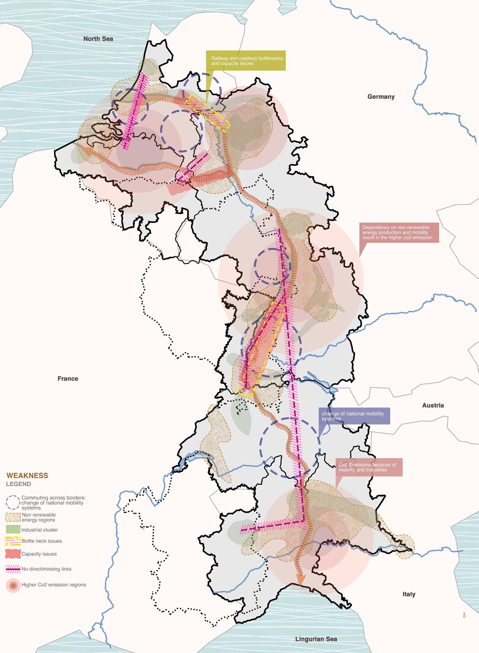
3.5. SWOT: Weaknesses
The weaknesses across the Rhine-Alpine corridor are as follows: There are railway and roadway bottlenecks and capacity issues. The dependency on non renewable energy production and mobility results in the higher CO2 emissions. In regions with high industrial volume, the CO2 emissions cause
environmental havoc. A lack of direct rail links across the corridor are apparent. The missing connections lead to long commuting hours for travelers. The change on national mobility system is another factor that creates hurdles. In addition, there’s a cross border socio-economic imbalance.
Collaborate | Co-create | Connect 19 Collaborate | Co-create | Connect
Graphics: Authors.
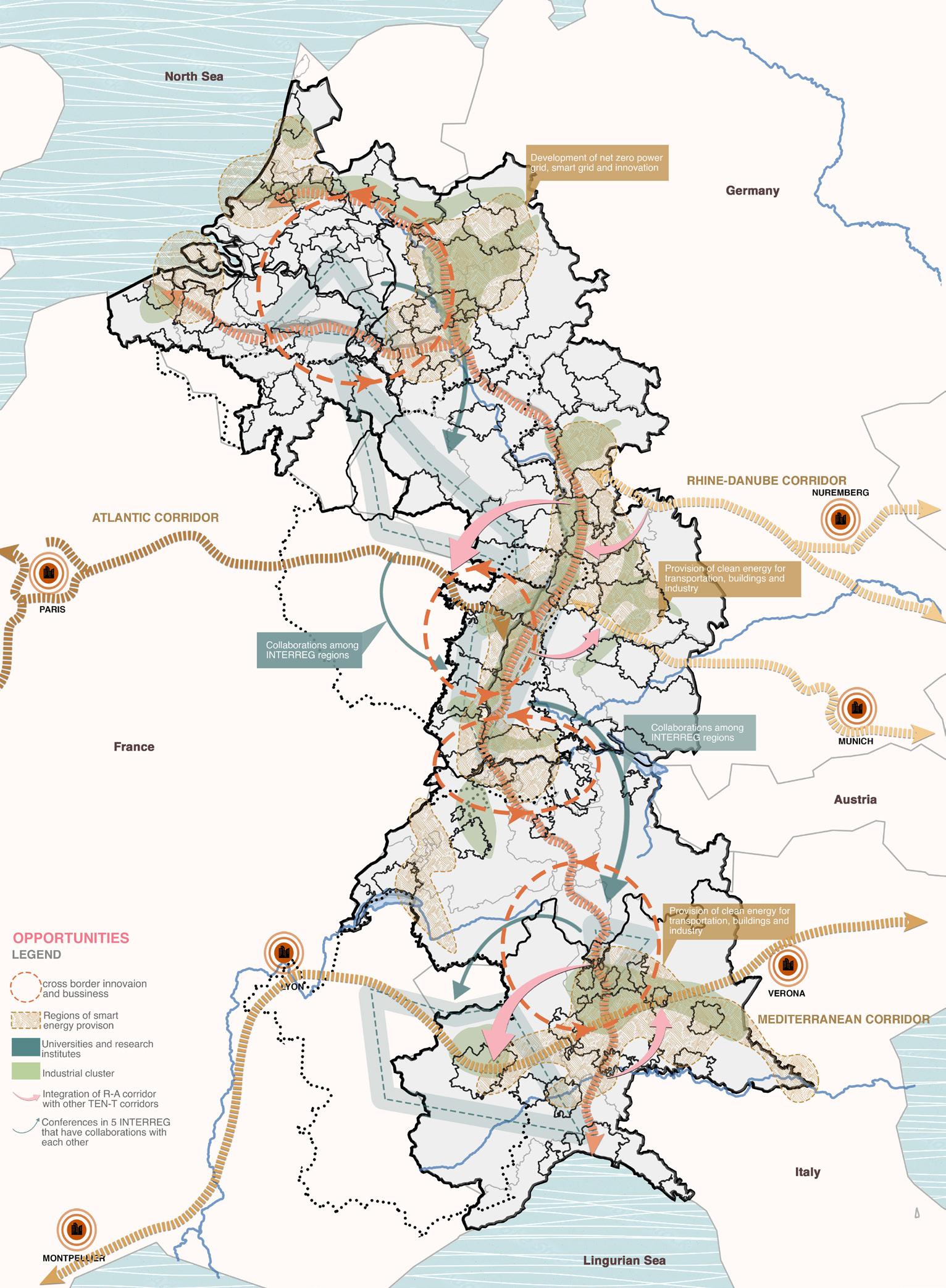
3.5. SWOT: Opportunities
The opportunities across the Rhine-Alpine corridor are various: There are developments of net zero power grid, smart grid and innovation. There are collaborations and conferences between the five INTERREG
among each other. There’s Integration of R-A corridor with other TEN-T Corridors. There’s a provision of clean energy, transportation, buildings and industry.
Collaborate | Co-create | Connect 20 Collaborate | Co-create | Connect
Graphics: Authors.
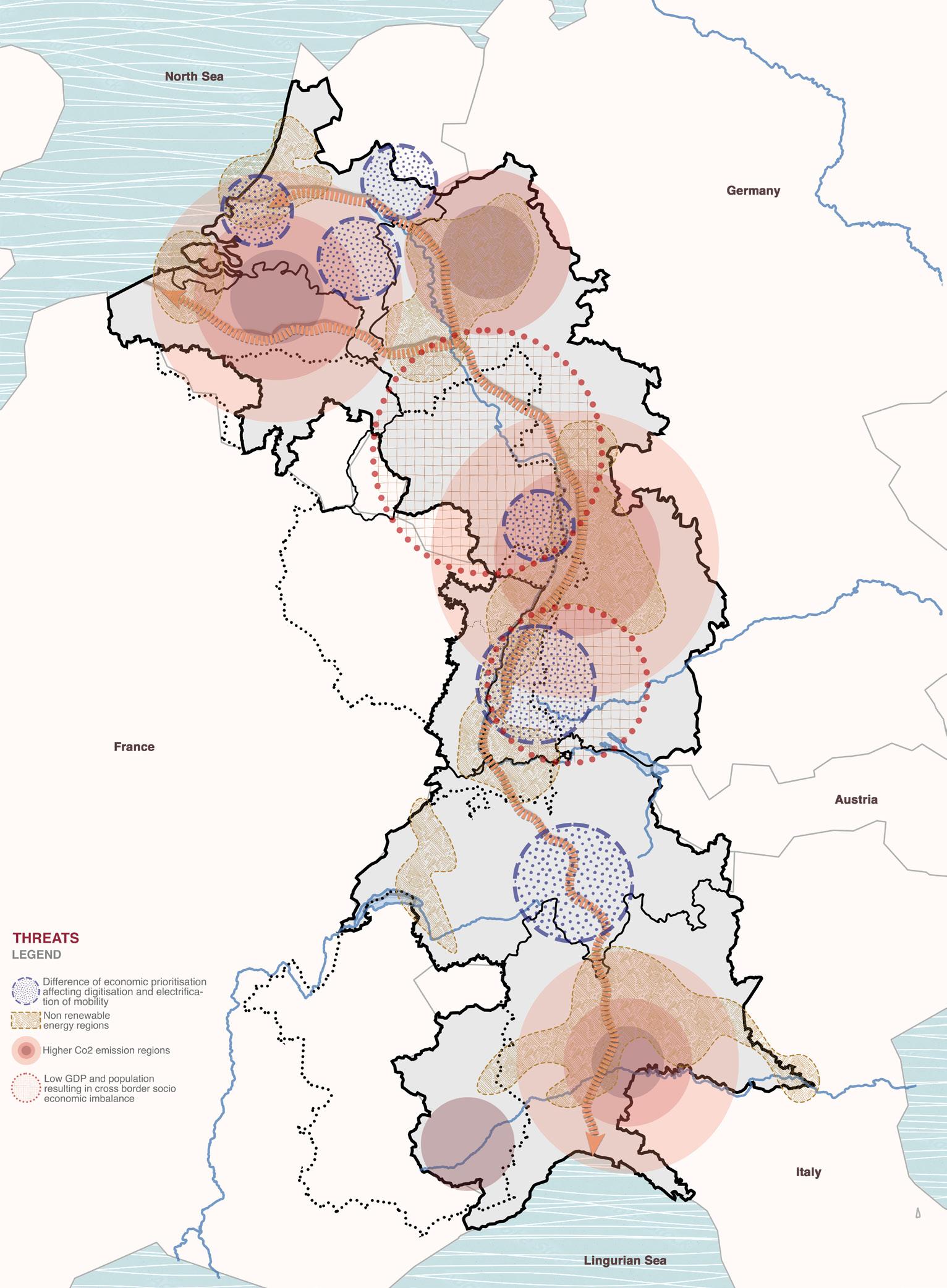
3.5. SWOT: Threats
Graphics: Authors.
There’s a difference of economic priorities affecting digitization and electrification of mobility. The dependency on non-renewable energy sources in various regions results in higher CO2 emissions.
Regions with low GDP and population are the leading cause of cross border socio economic imbalance.
Collaborate | Co-create | Connect 21 Collaborate | Co-create | Connect
CHAPTER - 4 VISION
Collaborate | Co-create | Connect 22 Collaborate | Co-create | Connect
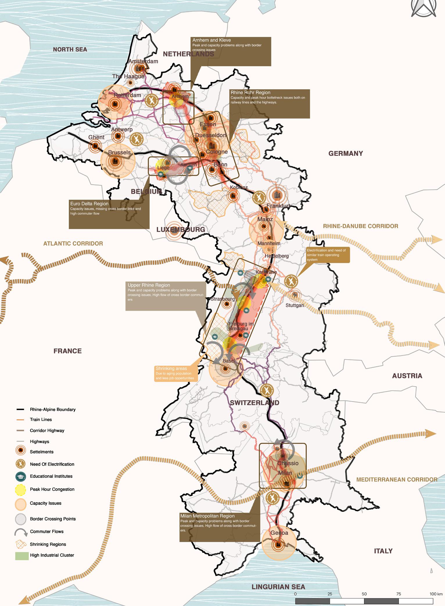
4.1.1. Polycentric Urban Systems: Focus Areas
The analysis showed five focus areas that are the most problematic which are as follows: Arhnem and Kleve show peak and capacity problems with border crossing issues. Rhine Ruhr Region has capacity and peak hour bottleneck issues both o n railway lines and the highways. Euro Delta Region has capacity issues, missing cross border links and high commuter flow. Upper Rhine Region has peak and capacity problems along with border crossing issues and high flow of cross border commuters. There are shrinking areas due to
aging population and less job opportunities. There’s an apparent need for electrification and similar train operating system. Milan Metropolitan Region has peak and capacity problems along with border crossing issues and a high flow of cross border commuters.
Collaborate | Co-create | Connect 23 Collaborate | Co-create | Connect
Graphics: Authors.
4.1.1. Polycentric Urban Systems: Polycentric Hubs & Approaches
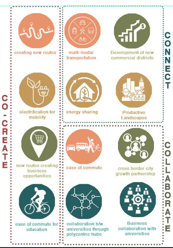
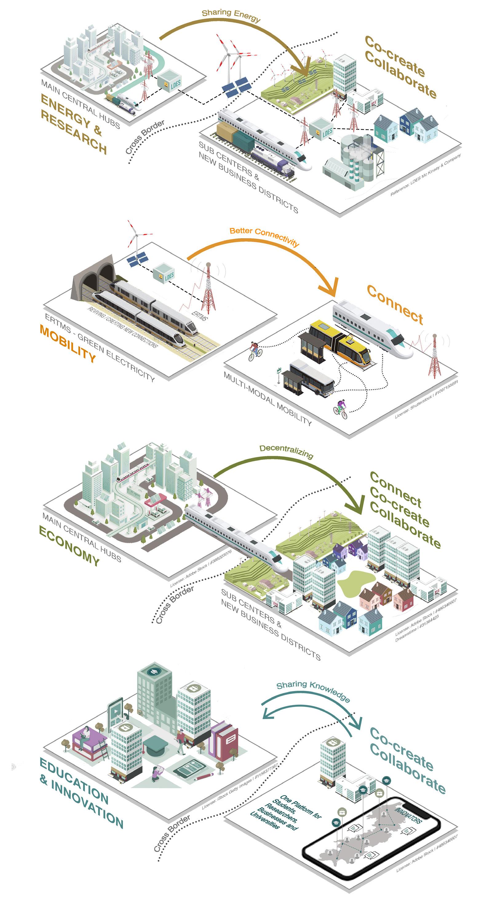
From the inference map, we have concluded four major themes for the focus of our project. These themes are Mobility, Energy and research, economy and education. Polycentric hubs are territorial patterns that encourage more balanced development between regions and more co-operative urban-rural relationships. Critical economic mass is created by combining the efforts of urban centers. Polycentric development is not about cities making massive investments in order to grow bigger. Instead it is about building linkages and joining forces with neighboring cities and towns in order to ensure positive spill-over effects for the development of wider regions. In a nutshell Polycentric hubs are a model where all jobs are located in a finite set of employment center - including Central business District (CBD) scattered throughout
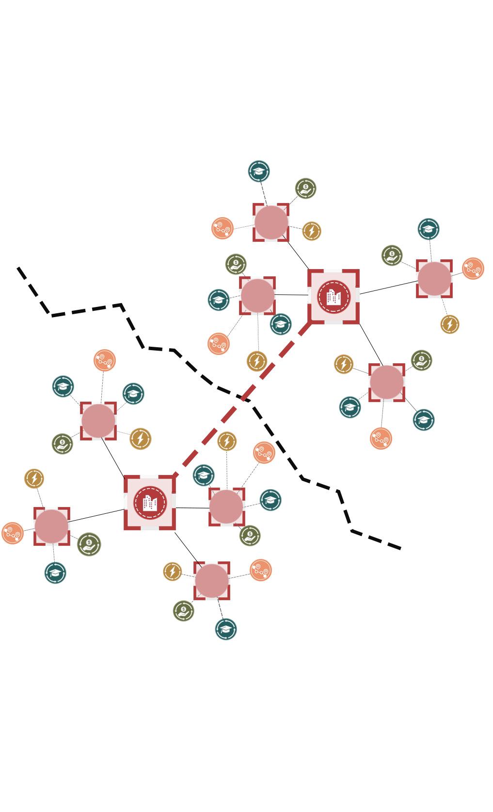
the metropolitan area. In order to achieve this vision we have prepared a thematic approach which includes 3c’s i.e connect, collaborate and co-create within all the focused themes. By connecting Mobility (creating new routes, multi modal transport and ease of commute), energy (electrification for mobility), Economy (Cross border city growth partnership) and education (business collaborations with universities). Collaborating energy sharing and productive landscape with development of new commercial districts. Collaboration between universities through polycentric hubs, business collaboration with universities to develop cross border city growth partnership. Co-creating economy, energy and education by creating business opportunities, ease of commute for education and energy sharing.
Collaborate | Co-create | Connect 24 Collaborate | Co-create | Connect
Graphics: Authors.
4.1.2. Polycentric Urban Systems: Stakeholders
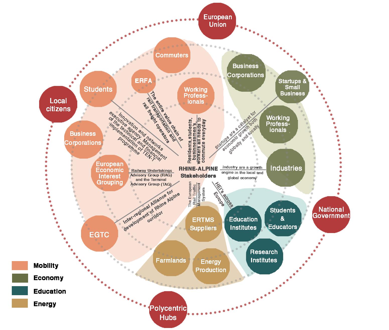
Stakeholders are an integral part of the project. Public-private partnerships play a vital role for the successful outcome of the projects. We have identified several stakeholders in theme focused areas. We have a diversity of stakeholders along the Rhine- Alpine corridor. For mobility we identified several countries: the Ministry of transportation, Railway undertaking advisory groups, Rail transportation and freight operators, Inter regional alliance for development of Rhine Alpine corridor.
For the economy , several Industries along
the corridor, small, medium and large scale business. Business corporations, startups and working professionals. For the energy farmlands, energy production industries, ERTMS (European Rail Traffic Management System) and for the education, students and educators, Education and research institutes are identified potential stakeholders. And the European Union, National government, polycentric hubs and local citizens are the stakeholders responsible for all the categories.
Collaborate | Co-create | Connect 25 Collaborate | Co-create | Connect
Graphics: Authors.
CHAPTER - 5
DESIGN INTERVENTIONS
Collaborate | Co-create | Connect 26 Collaborate | Co-create | Connect
5.1.1. Rhine-Alpine Corridor: Concept Maps - Mobility
The idea firstly is to create and revive new railway lines where we had missing links, these new connections would connect the other European corridors that run along the Rhine-Alpine Corridor.
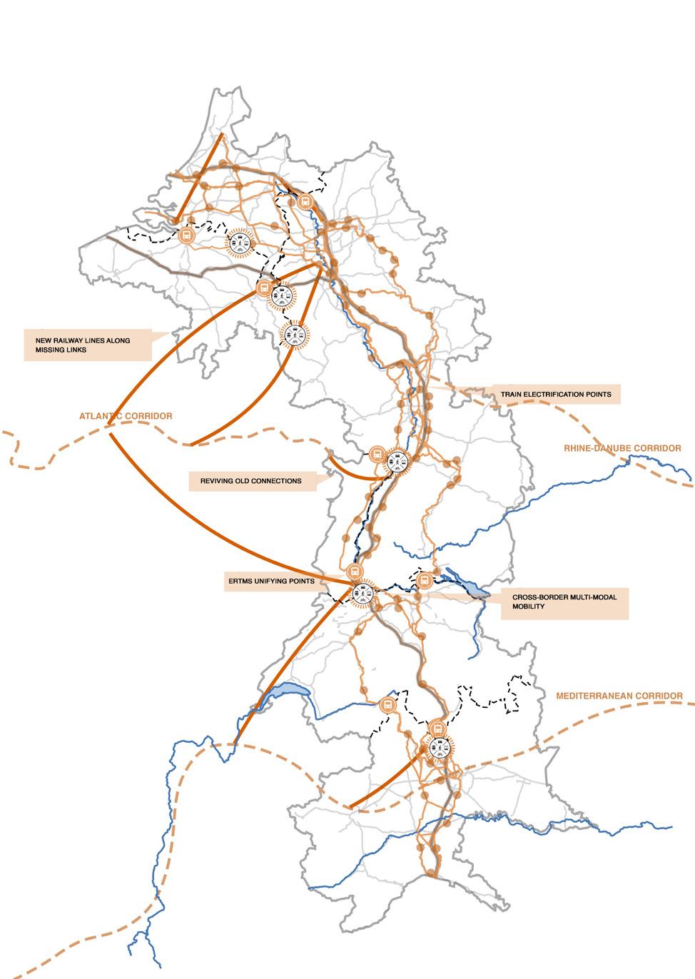
Next we proposed that the entire corridor have one unifying ERTMS Rail management system that would make it easier for countries with different languages and systems to have better and faster communication.
We also proposed cross-border Multi-mobility junctions which would include uniform road widths where necessary to avoid bottlenecks and cycle tracks for ease of commute.
Graphics: Authors.
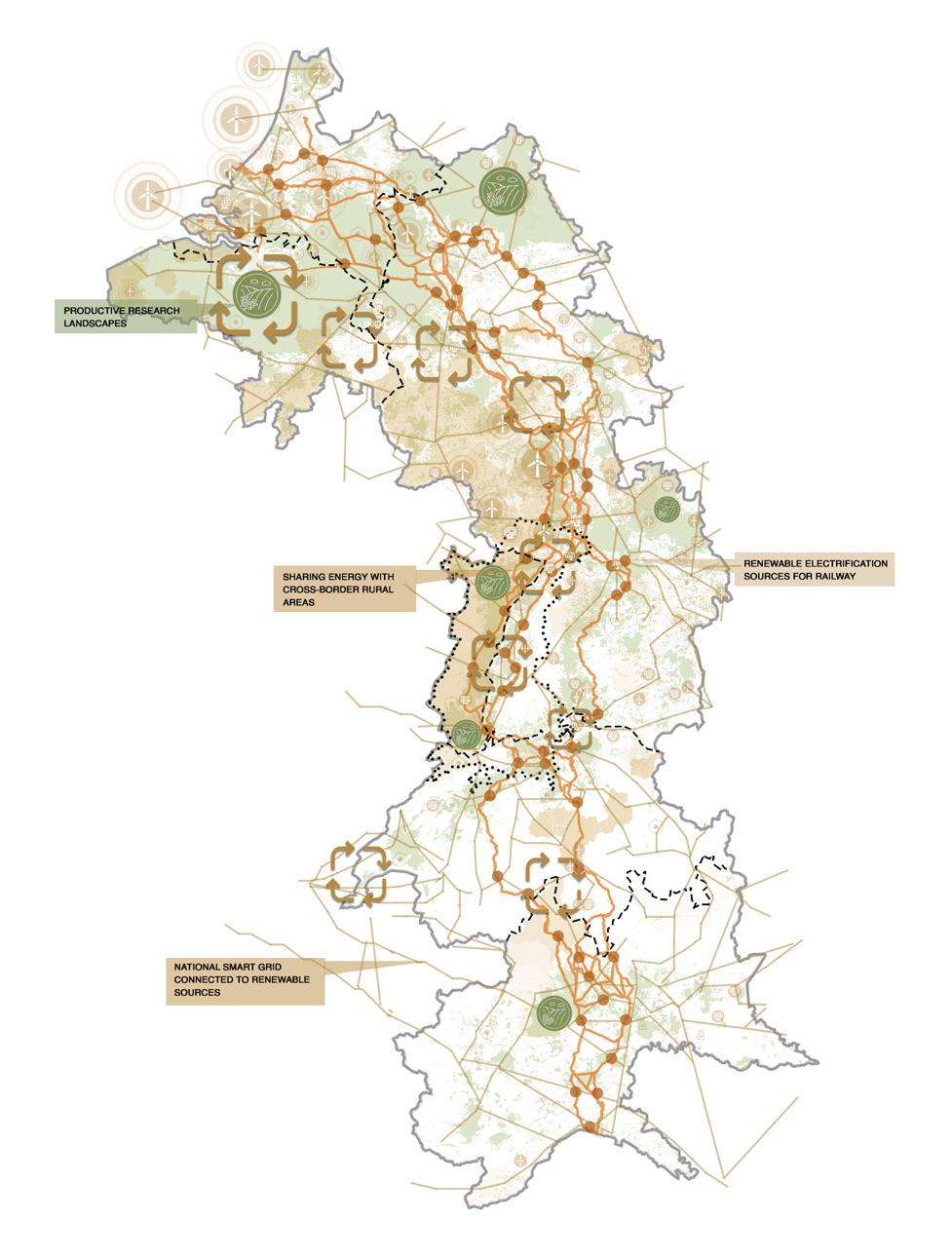
5.1.1. Rhine-Alpine Corridor: Concept Maps - Energy and Research
We propose Renewable electrification sources for transport by laying a smart grid that connects renewable energy power plants.
We propose to have a system of cross-border energy sharing through the smart grid in areas with less number of renewable power plants.
Thirdly we propose productive research landscapes that bring in commuters and uplift the economy.
Graphics: Authors.
Collaborate | Co-create | Connect 27 Collaborate | Co-create | Connect
5.1.1. Rhine-Alpine Corridor: Concept Maps - Economy
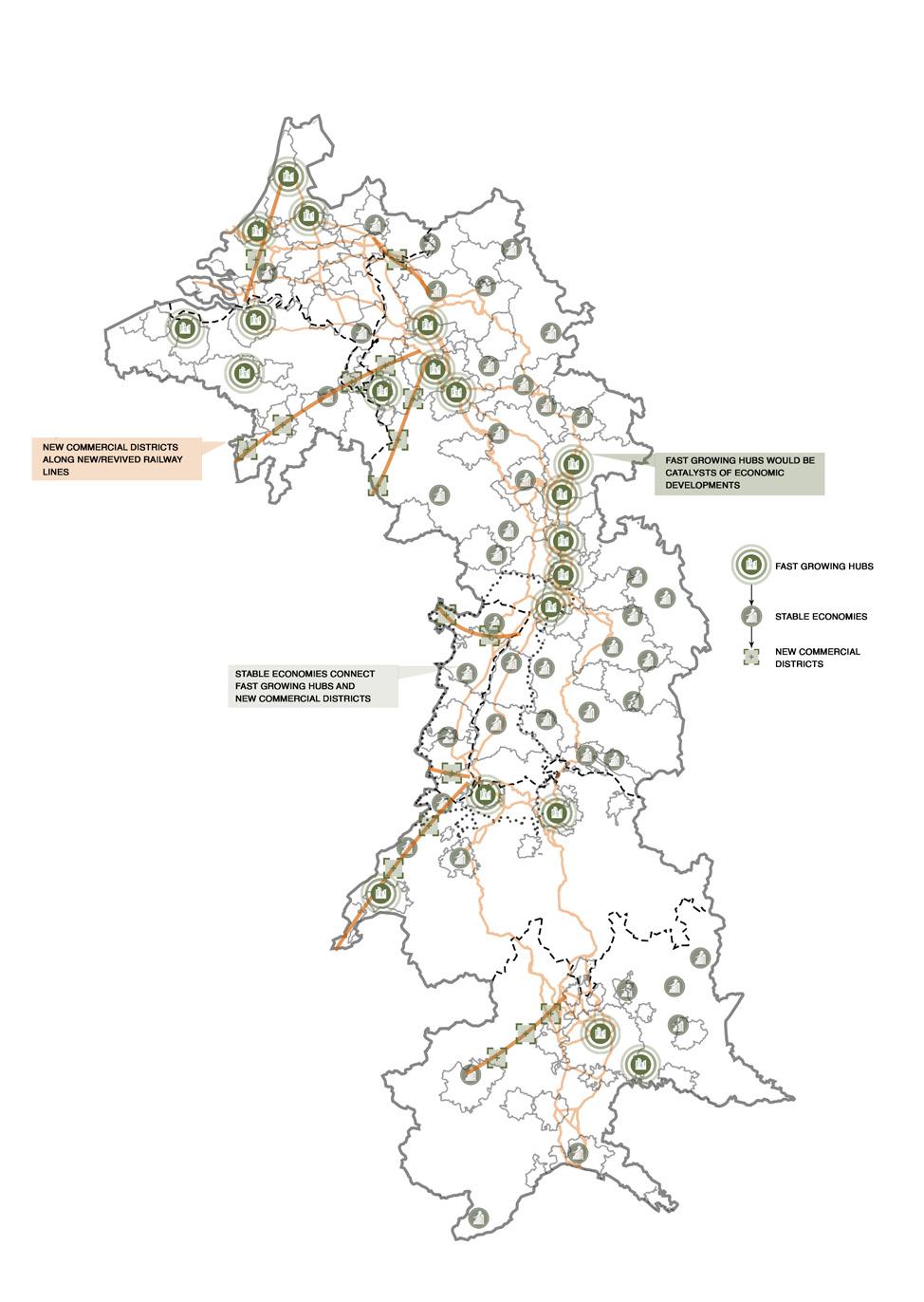
As there are new connections, the rural areas along the train lines are proposed as new commercial districts that would boom in business activities.
From our analysis we identified Fast Growing Hubs and Functional Urban Areas that could be our main centers of approach that would collaborate and support the new commercial districts.
Graphics: Authors.
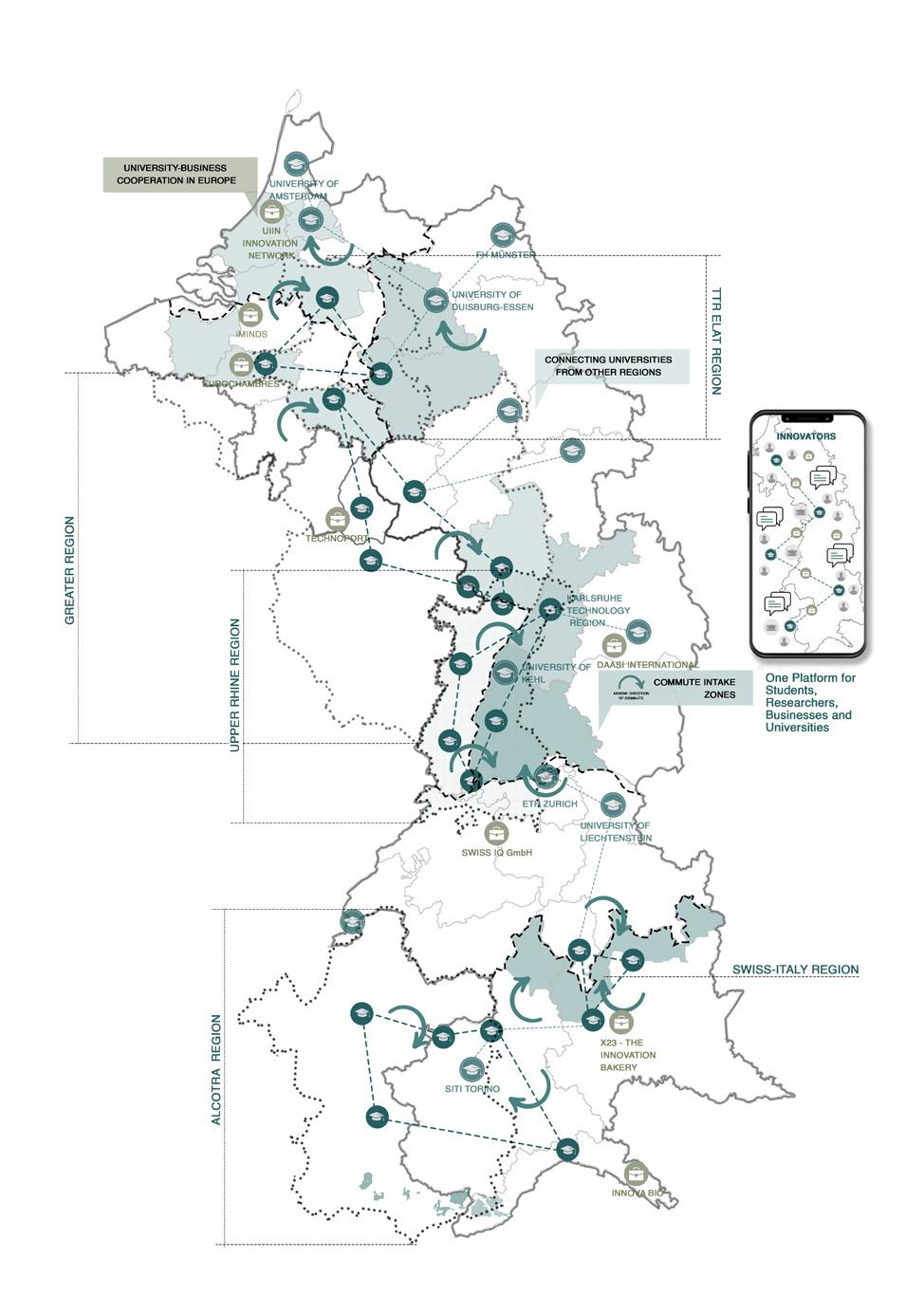
5.1.1. Rhine-Alpine Corridor: Concept Maps - Education
The educational institutions of identified INTERREG regions would be connected with institutions of other regions along the corridor.
A collaboration between UniversitiesBusinesses and Research centers is proposed through an online platform where they can learn and technologically and economically grow together.
Graphics: Authors.
Collaborate | Co-create | Connect 28 Collaborate | Co-create | Connect
5.1.2. Rhine-Alpine Corridor: Strategies
Graphics: Authors.
Collaborate | Co-create | Connect 29 Collaborate | Co-create | Connect
5.1.3. Rhine-Alpine Corridor: Master Plan
Graphics: Authors.
Collaborate | Co-create | Connect 30 Collaborate | Co-create | Connect
The strategies and schemes are translated into a programmatic decentralization under the Main Polycentric Hubs that include Fast Growing Areas defined by MCKinsey and Company and major Functional Urban Areas defined by OECD.
These Major Central Hubs are connected with each other and act as catalysts of our approaches and further connect to the SubCentral Hubs that manage and organize Mobility, Education, Energy and Economy in the various regions as well as supporting
the Shrinking Regions and Non-metropolitan areas coming under them.
This all-in-all creates a decentralization of responsibilities from Major Hubs to Sub Hubs and then to smaller cities. The Major hubs could further connect to Megacities and other fast Growing areas outside of the RhineAlpine Corridor.
5.2.1. PAMINA: Regional Analysis - Mobility
Graphics: Authors.
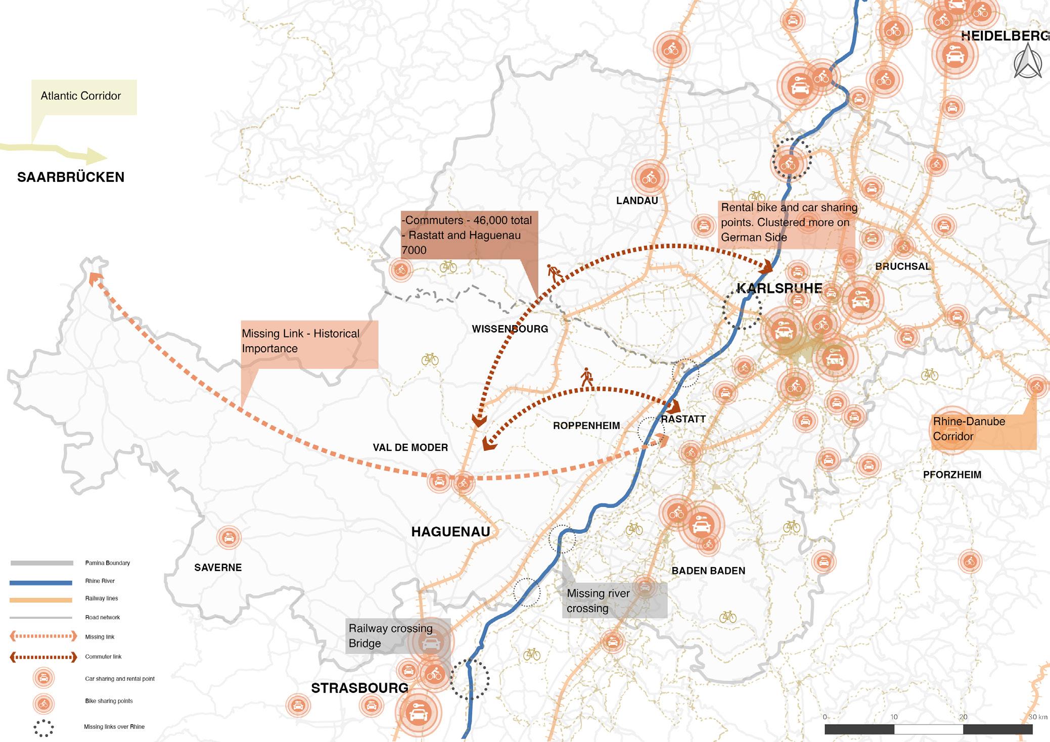
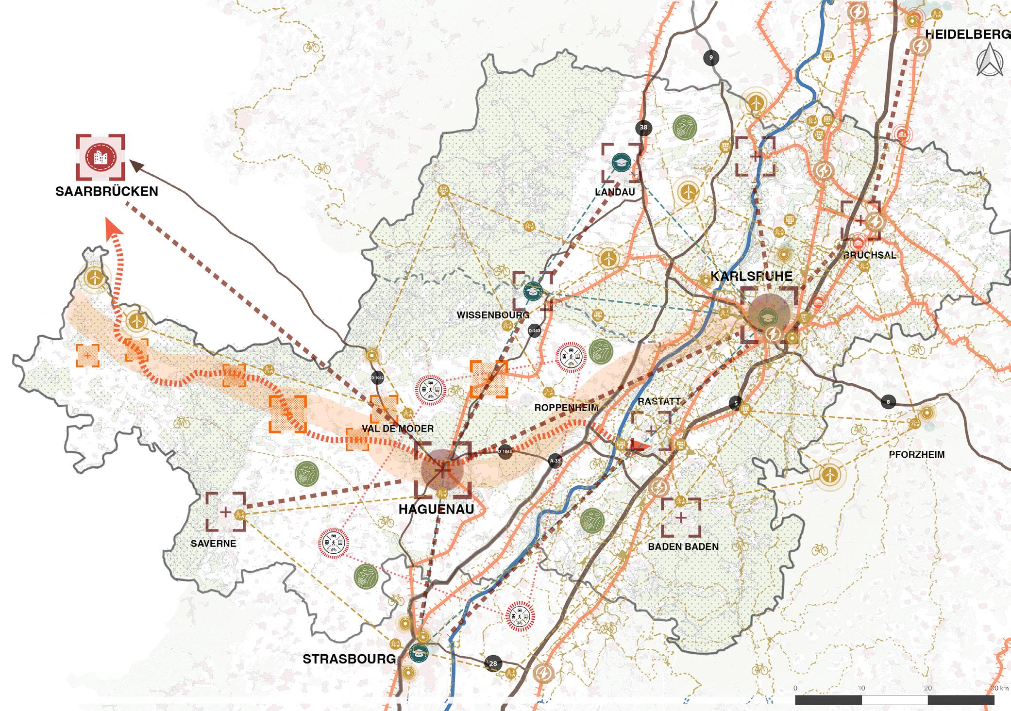
The PAMINA region is home to 46,000 total commuters, and 7000 of these are only between Rastatt and Haguenau. The only direct connections between the French and German side are from road.
There’s a missing historical link that connects the region to the Atlantic corridor. The rental bike and car sharing points are clustered more on the German side.
Collaborate | Co-create | Connect 31 Collaborate | Co-create | Connect
5.2.1.
PAMINA: Regional Analysis - Energy and Research
Graphics: Authors.
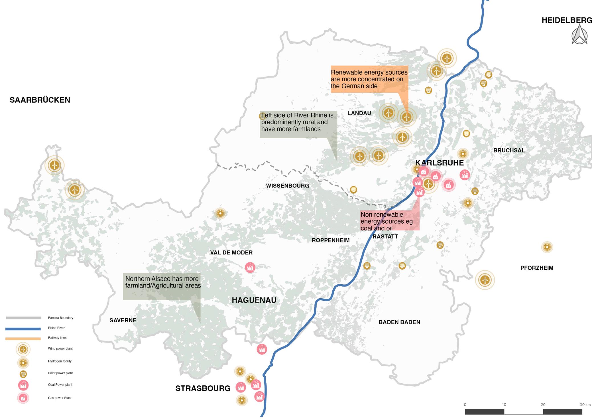
The Northern Alsace has more farmland/ Agricultural areas. The left side of River Rhine is predominantly rural and has more farmlands. The renewable energy sources are more concentrated on the German side.
The non renewable energy sources are mostly located around Karlsruhe and Strasbourg, these are mainly coal and gas.
Collaborate | Co-create | Connect 32 Collaborate | Co-create | Connect
5.2.1. PAMINA: Regional Analysis - Economy & Education
Graphics: Authors.
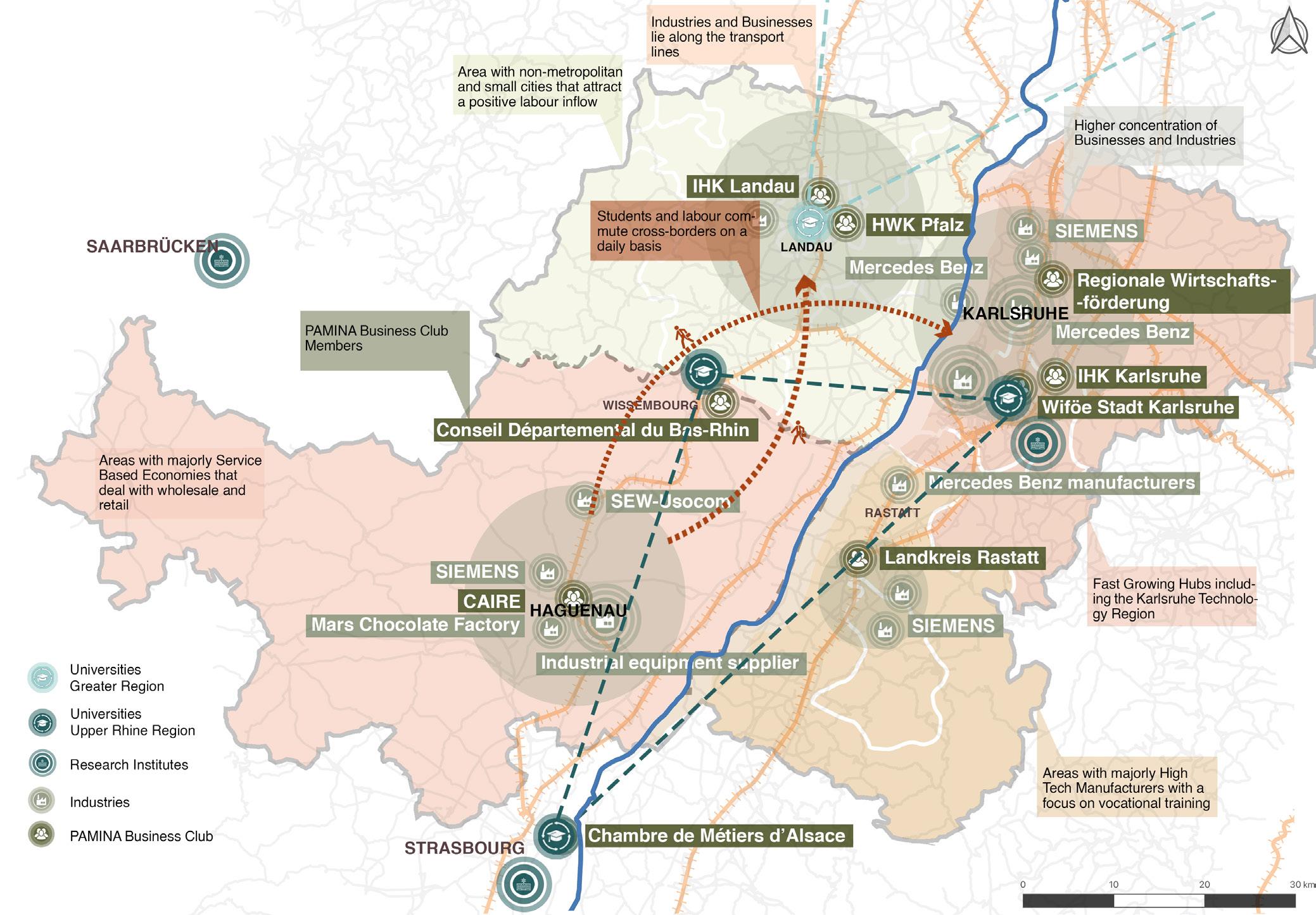
The Karlsruhe Technology region is among the fastest growing hubs. Around the region, there are areas with major High Tech Manufacturers with a focus on vocational training. It has also has the highest concentration of Businesses and Industries. There are non-metropolitan areas and small cities close to Landau that attract a positive labor flow. The Industries and Businesses lie along the transport lines in Landau. Students
and labors commute on a daily basis from the French side to the German. The French side has areas with major Service Based Economies that deal with wholesale and retail. PAMINA region has a cooperation that spreads across in the shape of PAMINA Business club.
Collaborate | Co-create | Connect 33 Collaborate | Co-create | Connect
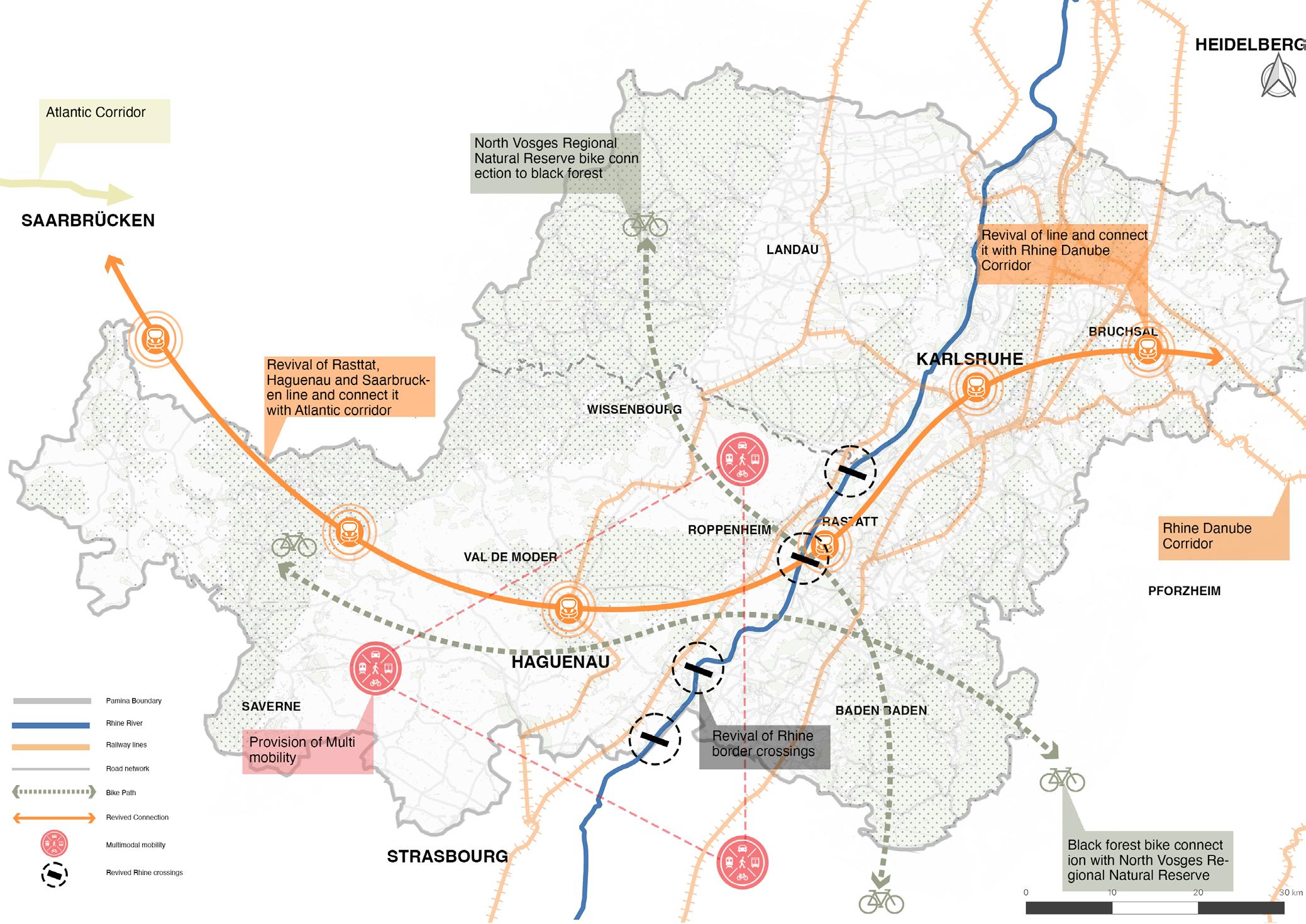
5.2.2. PAMINA: Concept Maps - Mobility
Graphics: Authors.
The strategy is to revive the connection of Rastatt, Haguenau and Saarbrucken line and connect it with the Atlantic corridor. This would connect it to the Rhine Danube corridor in turn as well. The North Vosges Regional
Natural Reserve will be connected to the Black Forrest through bike routes. The missing river crossings are revived through border crossing over the Rhine. The strategy is to enable multi-modality across PAMINA.
Collaborate | Co-create | Connect 34 Collaborate | Co-create | Connect
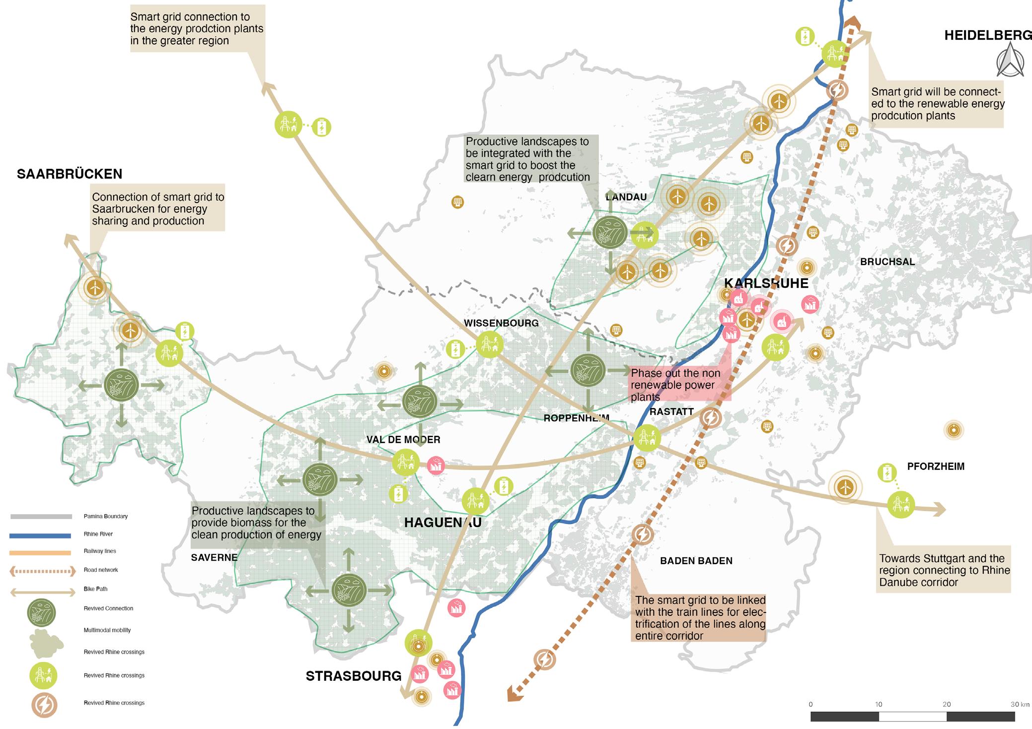
5.2.2. PAMINA: Concept Maps - Energy and Research
Graphics: Authors.
We propose connection of smart grid to Saarbrucken for energy sharing and production. These smart grids will be connected to the energy production plants in the greater region, and on the other side towards Stuttgart and the region connecting to Rhine Danube corridor. Furthermore, the
smart grid will be linked with the train lines for electrification of the lines along entire corridor. We propose to phase out the non-renewable power plants with the means of productive landscapes - these will provide biomass and will be integrated with the smart grid for the clean production of energy.
Collaborate | Co-create | Connect 35 Collaborate | Co-create | Connect
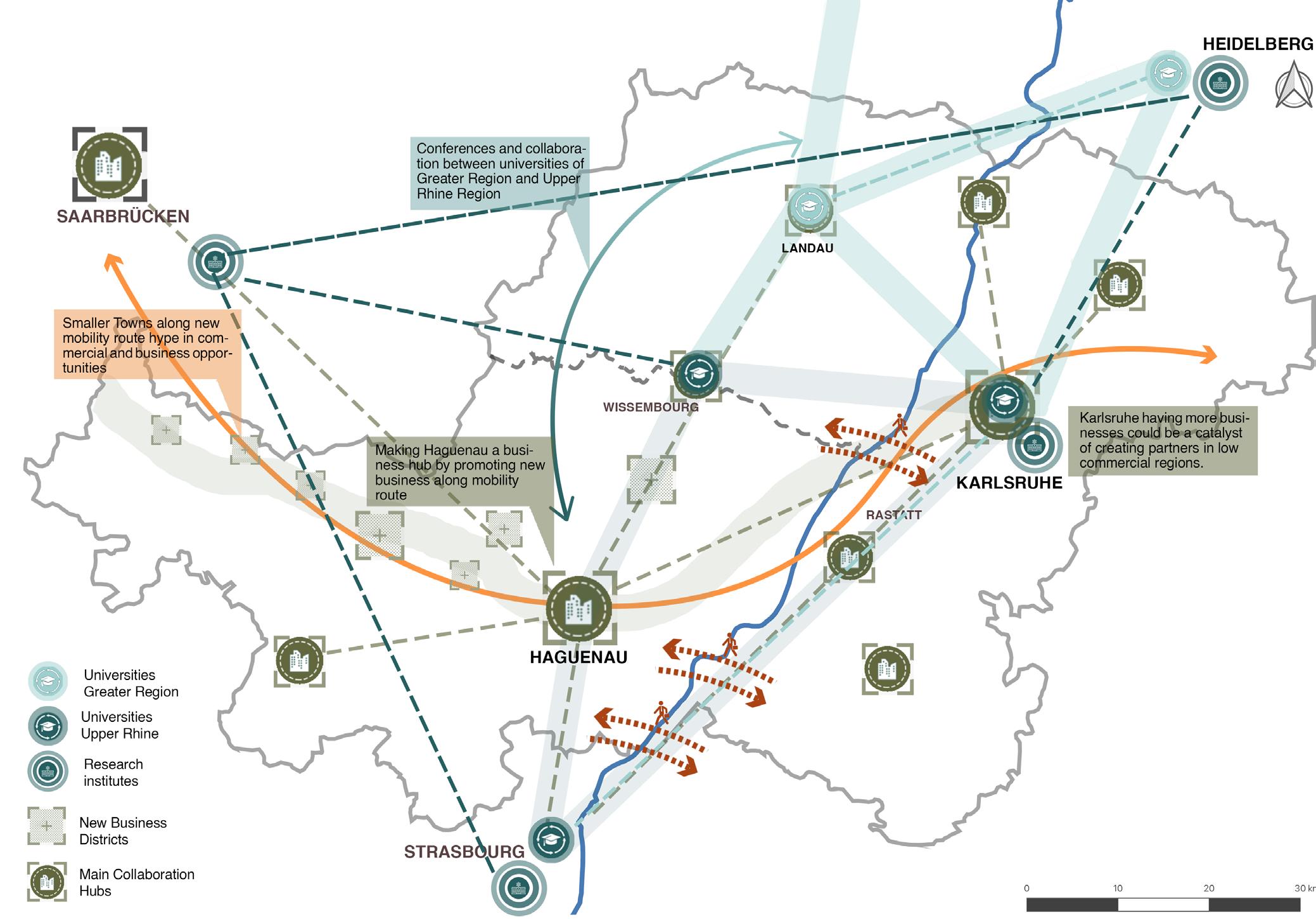
5.2.2. PAMINA: Concept Maps - Economy & Education
Graphics: Authors.
The main strategy is to create cross border collaboration hubs and new business districts in the PAMINA region. There are smaller towns along the new proposed mobility route, which in turn open up commercial and business opportunities. The goal is to make Haguenau a business hub by promoting new businesses along the mobility route.
Since Karlsruhe has the most businesses, it could be a catalyst for creating partners in low commercial regions. The educational strategies would enable conferences and collaborations between universities of Greater Region and Upper Rhine Region.
Collaborate | Co-create | Connect 36 Collaborate | Co-create | Connect
5.2.3. PAMINA: Regional Master Plan
Overall, EuroDistrict PAMINA is one of the key regions in the Rhine-Alpine Corridor due to its Tech region, Educational Institutes and high manufacturing industry. It is also a region with a high commuting flow and cross border activities but on the other hand the region also lags behind than the other parts of the corridor due to various issues which affect the residents of the region on various scales and in various departments for cross border mobility to Socio Economic conditions etc. Therefore it is a region with the high potential and it also provides good opportunities for cross border development and plays an
important part in the overall development and implement of the vision for the Rhine-Alpine Corridor.
The master plan of EuroDistrict PAMINA identifies the problems in detail which play an important part in the entire Corridor and sums up the solutions which are related to the broader vision of the Rhine-Alpine corridor. It addresses the issues related to the Mobility, Socio Economy and Education & Innovation and provides the best possible solutions for the long term development of the region along with the entire Rhine-Alpine Corridor.
Collaborate | Co-create | Connect 37 Collaborate | Co-create | Connect
Graphics: Authors.
CHAPTER - 6 CONCLUSION
Collaborate | Co-create | Connect 38 Collaborate | Co-create | Connect
4.1.1. Polycentric Urban Systems: Focus Areas
Graphics: Authors.
Collaborate | Co-create | Connect 39 Collaborate | Co-create | Connect
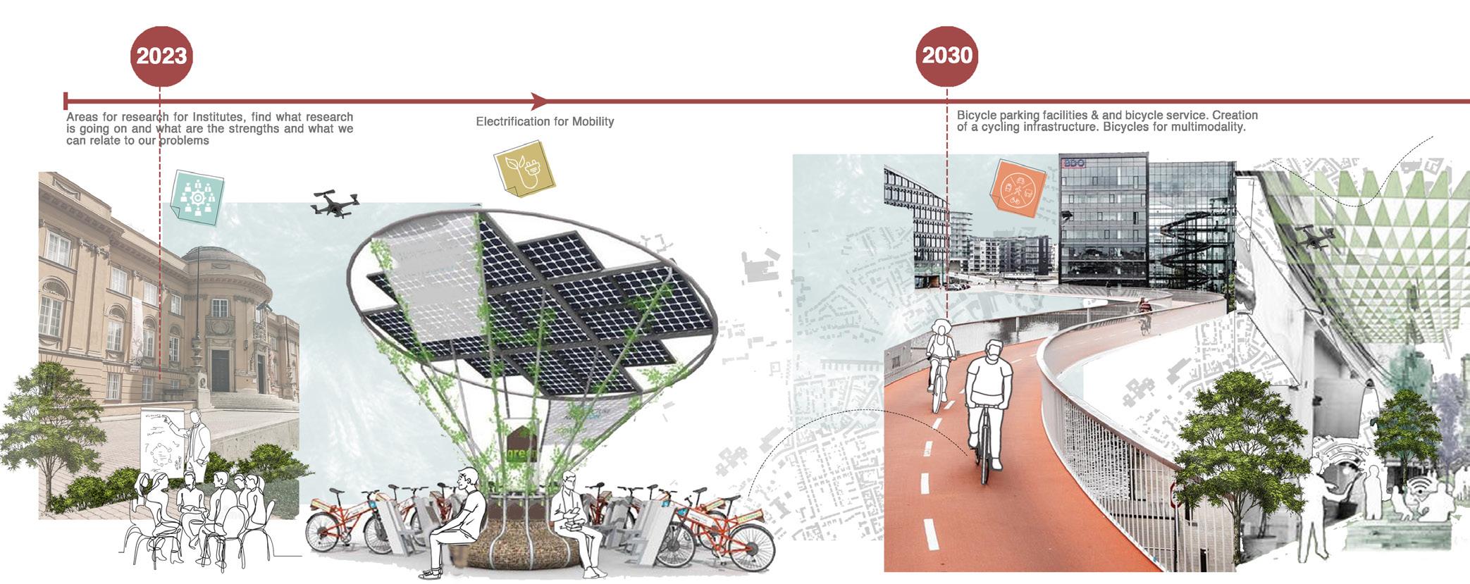
We have prepared a timeline and dedicated short-term, mid-term and long - term goals. Our short term goals include strengthening collaborations between Educational and research institutions and business cooperations, planning conferences and delegations. Providing electrical charging stations for mobility on roads and cycle tracks. This goal aims to be fulfilled by the year 2030.
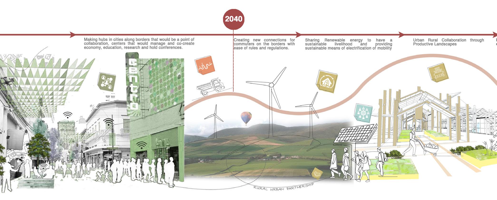
Between 2030-2040, we aim to provide bicycle parking facilities and service. Creation of cycling infrastructure and bicycle as a multimode transportation. Making hubs in cities along the border that would be a point of collaboration, centers that would manage and co-create economy, education, research and hold conferences.
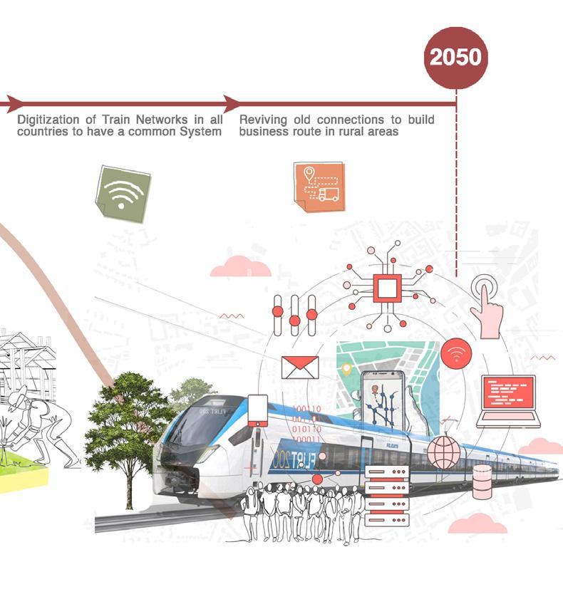
And finally for the year 2050, creating new connections for commuters on the border with ease of rules and regulations.
• Sharing renewable energy to have a sustainable livelihood and providing sustainable means of electrification of mobility through smart grid.
• Urban rural collaborations through productive landscape.
• Digitization of train networks in all countries to have a common system
• Reviving old connections to build business routes in rural areas
To conclude, polycentric development can contribute to reducing regional disparities at all levels. This avoids further excessive economic and demographic concentration within the core areas at EU and national scales and revitalizes less densely settled and economically weaker regions. In the long run, polycentric development contributes to making cities and regions more resilient and diversified, which strengthens the competitiveness of Europe in the global economy.
Collaborate | Co-create | Connect 40 Collaborate | Co-create | Connect
CHAPTER - 7 REFERENCES
Collaborate | Co-create | Connect 41 Collaborate | Co-create | Connect
7. References
1. CEF support to Rhine - Alpine Corrido. (2018) Available at; <https://wayback.archive-it. org/12090/20221204065308/https://ec.europa.eu/inea/sites/default/files/201803_corridor_ report_rhinealpine_withcover.pdf>
2. Comprehensive analysis of the existing cross-border rail transport connections and missing links on the internal EU borders. (2018) Available at; <https://ec.europa.eu/regional_policy/en/ information/publications/reports/2018/comprehensive-analysis-of-the-existing-cross-borderrail-transport-connections-and-missing-links-on-the-internal-eu-borders>
3. Corridor Rhine-Alpine. (2022) Available at; <https://www.corridor-rhine-alpine.eu/home. html>
4. Environmental interactive maps. (2023) Available at; <https://www.eea.europa.eu/data-andmaps/explore-interactive-maps#c0=5&c5=air&b_start=0>
5. Eurodistrict PAMINA. (2023) Available at; < https://www.eurodistrict-pamina.eu/UserFiles/ File/transports-mobilite/dossier-missing-link-english.pdf>
6. Eurodistrict PAMINA. (2023) Available at; <https://www.eurodistrict-pamina.eu/fr/transportsmobilite.html#.Y_v0mR_MJPZ>
7. Eurostat. (2023) Available at; <https://ec.europa.eu/eurostat/cache/RCI/#?vis=nuts2. labourmarket&lang=En>
8. European Urban System: Metropolization and Networking. (2009) Available at; <https:// www.researchgate.net/publication/303495958_EUROPEAN_URBAN_SYSTEM_ METROPOLIZATION_AND_NETWORKING>
9. European OpenGHGMap. (2018) Available at; <https://openghgmap.net/data/>
10. Federal Agency for Cartography and Geodesy (2022). Available at; <https://www.bkg. bund.de/EN/Home/home.html>
11. GridX (2023). Available at; <https://www.gridx.ai/resources/digitalization-in-the-energyindustry>
12. Heidelberg Institute for Geoinformation Technology at Heidelberg University. (2022) Available at; <https://heigit.org/>
13. Knowledge Transfer Upper Rhine. (2023) Available at; < https://ktur.eu/en/offers/ innovation-events/>
14. Long-distance cross-border passenger rail services. (2017) Available at; <https:// op.europa.eu/en/publication-detail/-/publication/34244751-6ea3-11ec-9136-01aa75ed71a1>
Collaborate | Co-create | Connect 42 Collaborate | Co-create | Connect
15. Net-zero power Long duration energy storage for a renewable grid. (2021) Available at; <https://www.mckinsey.com/~/media/mckinsey/business%20functions/sustainability/our%20 insights/net%20zero%20power%20long%20duration%20energy%20storage%20for%20a%20 renewable%20grid/net-zero-power-long-duration-energy-storage-for-a-renewable-grid.pdf>
16. OECD. (2020) Available at; <https://www.oecd.org/cfe/regionaldevelopment functionalurbanareasbycountry.htm>
17. Openrouteservice. (2022) Available at; <https://openrouteservice.org>
18. Plugging in: What electrification can do for industry. (2022) Available at; <https://www. mckinsey.com/industries/electric-power-and-natural-gas/our-insights/plugging-in-whatelectrification-can-do-for-industry>
19. Port, Industrial and Mineral Railways in Germany. (2022) Available at; <https://www.sinfin. net/railways/world/germany/industrie.html>
20. RheinCargo. (2023) Available at; <https://www.rheincargo.com/unternehmen/ nachhaltigkeit>
21. Statistisches Bundesamt (Destatis) (2023). Available at; <https://www.destatis.de/DE/ Service/Statistik-Visualisiert/_inhalt.html>
22. Spotlight Europe. (2019) Available at; <https://www.karlsruhe.de>
23. The Geography of Transport Systems. (2023) Available at; <https://transportgeography. org/contents/chapter2/geography-of-transportation-networks/transport-network-structuralcomponents/>
24. The Upper Rhine Conference. (2023) Available at; <https://www.oberrheinkonferenz.org/ de/services/english.html>
25. Urbantoolbox.it (2023) Available at; < http://www.urbantoolbox.it/project/egtc-rhine-alpinecorridor/>
26. Wojcieschowski, P.W (2022) Rhine Alpine, Fifth work plan of the European Coordinator
Collaborate | Co-create | Connect 43 Collaborate | Co-create | Connect