

V isions
ydro
HISSN 2837-5696
HYDROVISIONS is the official publication of the Groundwater Resources Association of California (GRA). GRA’s mailing address is 808 R Street. Suite 209, Sacramento, CA 95811. Any questions or comments concerning this publication should be directed to the newsletter editor at hydrovisions@grac.org
The Groundwater Resources Association of California is dedicated to resource management that protects and improves groundwater supply and quality through education and technical leadership.
EDITOR
Rodney Fricke hydrovisions@grac.org
EDITORIAL LAYOUT
Smith Moore & Associates
EXECUTIVE OFFICERS
PRESIDENT
Christy Kennedy
Woodard & Curran
Tel: 925-627-4122
VICE PRESIDENT
Erik Cadaret
Yolo County Flood Control & Water Conservation District
Tel: 530-756-5905
SECRETARY
Abhishek Singh
INTERA
Tel: 217-721-0301
TREASURER
Rodney Fricke
GEI Consultants
Tel: 916-407-8539
DIVERSITY, EQUITY AND INCLUSION OFFICER
Annalisa Kihara
State Water Resources Control Board
IMMEDIATE PAST PRESIDENT
R.T. Van Valer
ADMINISTRATIVE DIRECTOR
Amanda Rae Smith
Groundwater Resources Association of California asmith@grac.org
To contact any GRA Officer or Director by email, go to www.grac.org/board-of-directors
DIRECTORS
Jena Acos
Brownstein Hyatt Farber Schreck
Tel: 805-882-1427
Christopher Baker
DWR
Tel: 562-331-4507
Matthew Becker
California State Univ. Long Beach Tel: 562-985-8983
Trelawney Bullis
AC Foods, Central Valley
Tel: 530-205-8387
Dave Ceppos
Public Policy Mediation and Facilitaion
Tel: 916-539-0350
Elie Haddad
Haley & Aldrich
Tel: 408-529-9048
Dr. Hiroko Hort
GSI Environmental, Inc
Marina Deligiannis Stantec
Tel: 916-418-8242
Clayton Sorensen
West Yost Associates
Tel: 925.949.5817
Melissa Turner
MLJ Environmental Tel: 530-756-5200
Savannah Tjaden
Environmental Science Associates
Tel: 208-350-3566
Roohi Toosi
APEX Environmental & Water Resources
Tel: 949-491-3049
John Xiong
Haley & Aldrich, Inc.
Tel: 714-371-1800
The statements and opinions expressed in GRA’s HydroVisions and other publications are those of the authors and/or contributors, and are not necessarily those of the GRA, its Board of Directors, or its members. Further, GRA makes no claims, promises, or guarantees about the absolute accuracy, completeness, or adequacy of the contents of this publication and expressly disclaims liability for errors and omissions in the contents. No warranty of any kind, implied or expressed, or statutory, is given with respect to the contents of this publication or its references to other resources. Reference in this publication to any specific commercial products, processes, or services, or the use of any trade, firm, or corporation name is for the information and convenience of the public, and does not constitute endorsement, recommendation, or favoring by the GRA, its Board of Directors, or its members.
Parting Shot Page 24 6 Basin Characterization in California – How to Access Data, Maps, Conceptual Models, and Numerical Models

a call for creatiVe couraGe on subsidence
At the recent GRA SGMA Implementation and Legislative Summit in May, we had a unique moment that first day in the closing panel that captured both the gravity of our groundwater challenges—and the creative inertia we sometimes face when confronting them. The panel discussion was focused on land subsidence. In our beloved GRA “Reverse Panel” format where the panelists look to the audience to answer hard hitting questions, Aaron Fukada of Tulare Irrigation District spoke about focused recharge as primary solution for managing water levels and therefore subsidence, and asked the audience – about 150 groundwater industry representatives, what solutions they had to offer for the tricky challenge of subsidence. The room was surprisingly quiet. After a moment, one person hesitantly raised their hand and brought up the creative idea of a cross-field solution with injected concrete underground and wondered if that had been considered. There was a ripple of polite but dismissive laughter. And that moment stuck with me. Here we were, a room full of experts deeply committed to solving one of SGMA’s most visible and irreversible undesirable results—and yet when asked for bold, outside-the-box ideas, we were stumped. We chuckled at a potential creative linkage. But what if the real takeaway from that moment isn’t the feasibility of the idea—it’s that we need to get better at inviting, accepting, and nurturing unorthodox thinking.
We Need More Than Models and Monitoring

Subsidence is a stubborn problem. It doesn’t respond quickly to policy change. It lags behind our best data. And once aquifer compaction occurs, it can’t be undone. We know the science. We know the constraints. But incrementalism won’t save us. We need creative audacity. Could microbial geotechnologies reinforce clay layers? Could AI forecast where land will sink next season? Could construction techniques from mining or aerospace help stabilize overburden in critical recharge zones? These aren’t fully formed solutions—but they’re exactly the kind of multidisciplinary leaps we need to explore. And they are at the tips of our fingers when we engage with tools to support expansive thinking outside our normal avenues, but we haven’t stretched that muscle enough as an industry yet. At GRA, we have the community to bridge these divides. We are researchers, regulators, engineers, and communicators. We are optimists and pragmatists. And if ever there was a moment to push boundaries with subsidence, we are rapidly converging on it.
Borrowing Boldness from Other Fields
So, here’s my challenge to you: bring your wildest ideas to the table. No judgment. No scoffing. Let’s normalize the brainstorming that feels a little uncomfortable. Let’s fund pilot projects that may fail—but fail forward. Let’s continue to actively invite perspectives from disciplines we don’t yet understand.
Next year, let’s make sure the question about subsidence sparks not silence—but a flood of ideas. Let’s be the community that dreams as big as the challenges we face.
With appreciation and curiosity,

Christy Kennedy President, Groundwater Resources Association

Hydro Visions
basin cHaracterization in california – How to access data, MaPs, concePtual Models, and nuMerical Models
by Katherine Dlubac1, Benjamin Brezing1, Craig Altare1, Amanda Ott1, Michelle Zhang1, Steven Springhorn1
DWR’s Groundwater Basin Characterization Program (BC Program) builds off of DWR’s historical role in characterizing groundwater basins under California’s Groundwater and provides the latest data, maps, and conceptual models about California’s groundwater basins to help local communities better understand and manage their aquifer systems. As a part of the BC Program, DWR has expanded their efforts to acquire or digitize advanced geologic, hydrogeologic, and geophysical data to develop maps and conceptual models that describe aquifer properties, which support informed groundwater management.
To support map and conceptual model development, the BC Program is collecting and digitizing data through a series of local, regional, and statewide investigations. The data collected for each investigation will depend on local geology, data gaps, and investigation goals and may include infill airborne geophysics, surface-based geophysics, advanced geophysical logging, installing new wells, or reactivating existing wells, etc.
Lithology and geophysical logs are both valuable sources of information about aquifer properties that can be integrated with other existing data to create maps and conceptual models. However, the majority of the lithology and geophysical logs are available only as images and are not digitized (i.e. are not in a machine-readable format). Under the BC Program, lithologic descriptions and geophysical logs are being digitized after confirming an accurate location for each log.
Newly collected data and digitized logging data will be integrated and analyzed to develop state-stewarded maps and conceptual models that describe aquifer recharge potential, subsurface texture, and hydrostratigraphic properties (e.g., extent of important clays, subsidence potential, base of freshwater, and depth to basement). These maps and conceptual models support the implementation of SGMA and the development of local and regional numerical groundwater flow models, like DWR’s California Central Valley Groundwater-Surface Water Simulation Model – Fine Grid (C2VSimFG).
The BC Program publishes all data, maps, and models in a timely manner to ensure water managers have the most upto-date information when making groundwater management decisions. Additionally, the BC Program makes data, maps, and models available to view online through various visualization applications to ensure data access equity and promote transparency in our water management practices.
The following sections outline how to access or view datasets, maps, and conceptual models developed under the BC Program.
The Open Data Portal, SGMA Data Viewer, and California’s Groundwater Live
The primary website for posting and sharing DWR’s datasets is The California Natural Resources Agency (CNRA) Open Data Portal. The sections below highlight where various datasets, maps, and models can be accessed and downloaded.
isions
Many groundwater-related datasets are also available to view on DWR’s SGMA Data Viewer with topics organized under: Current Conditions, Groundwater Levels, Groundwater Storage, Water Quality, Land Subsidence, Interconnected Surface Water, Water Budget, and Basin Characterization. Recent updates to the SGMA Data Viewer aim at improving the user experience and ensuring easy access to data. The sections below highlight datasets that are available to view on the SGMA Data Viewer.
DWR also provides the most relevant and recent groundwater information on California’s Groundwater Live (CalGW Live). CalGW Live includes a series of dashboards which allow users to interact and customize what groundwater data they
would like to view. The user-friendly dashboards are designed to provide a high-level summary of groundwater-related information for a non-technical audience.
Statewide Airborne Electromagnetic Data
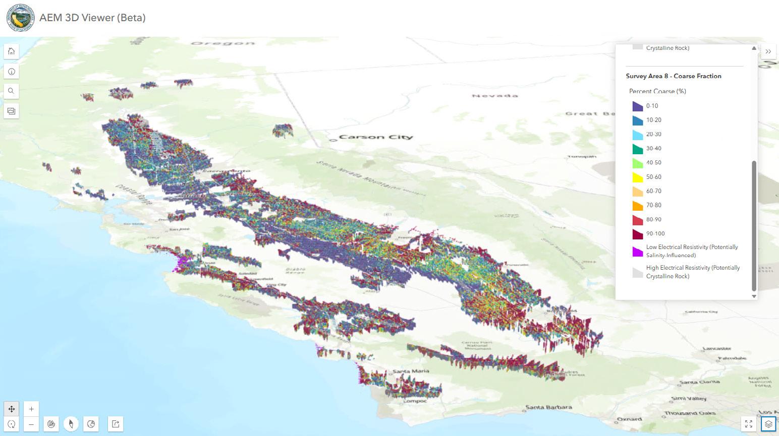
All Statewide AEM Survey Project data are available to download from the CNRA Open Data Portal. To support data access equity, DWR developed the AEM 3D Viewer, a novel, online, GIS-based viewer that allows the public to view and examine the AEM data in a three-dimensional space. The AEM 3D Viewer provides the public with an innovative way to visualize and understand the data collected in their groundwater basins (Figure 1).
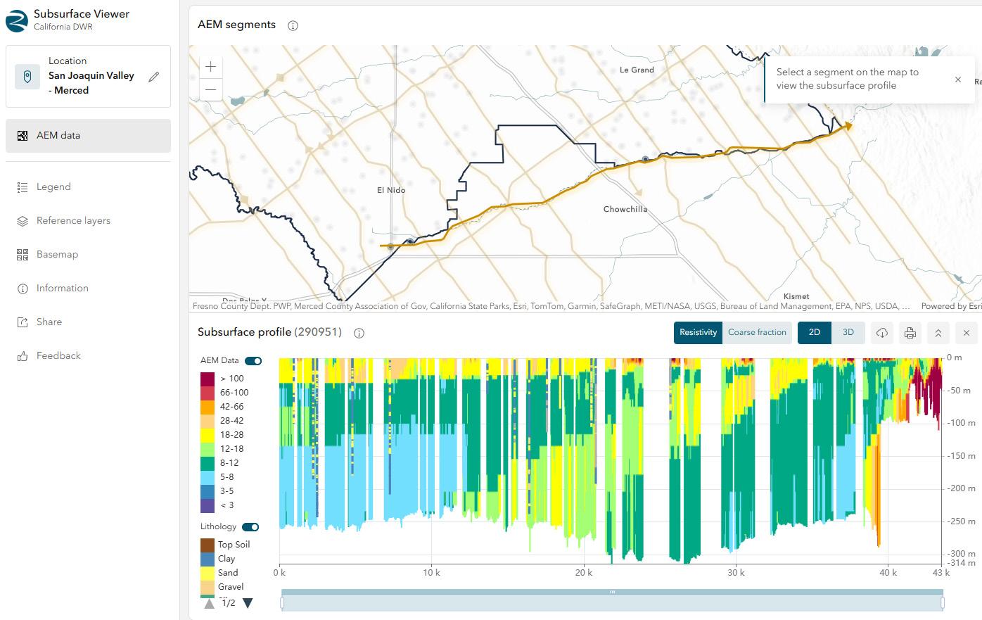
The BC Program has recently developed California’s Groundwater Subsurface Viewer (Figure 2), a new online, GIS-based, visualization tool that allows the user to dynamically view AEM and lithology log data while also allowing the user to view the geographic location on a map.
The Subsurface Viewer will eventually serve as a central hub for accessing and exploring groundwater-related data in California. These visualization tools enable both the public and technical users to interact with the data in a 3D space, providing a more immersive and informative experience.
article continues on next page
Figure 1: AEM 3D Viewer showing the AEM derived percent coarse grained material as fence diagrams.
The SGMA Data Viewer shows the following AEM datasets under the Basin Characterization tab:
• AEM Surficial Groundwater Recharge Map: the AEMderived average percent coarse-grained material from the surface to 50 feet deep.
• AEM Texture Model: depth slices of AEM-derived percent coarse grain material.
• Statewide AEM Surveys Profile Images: images showing electrical resistivity and percent coarse-grained material along AEM survey flight lines.
Digitized Lithology and Geophysical Logs
Groundwater well lithology logs from well completion reports (WCRs) are submitted to DWR through the Online System of Well Completion Reports (OSWCR) and the WCRs can be viewed through the Well Completion Report Map Application and the SGMA Data Viewer and all data are available to download from the CNRA Open Data Portal.
Oil and gas geophysical logs are submitted to the California Geologic Survey’s California Geologic Energy Management Division (CalGEM) through WellSTAR and well locations and information can be viewed through Well Finder. Geophysical well log data (raster data) are available by request.
A selection of lithology and geophysical logging data shared by locals or downloaded from OSWCR and WellSTAR were quality controlled for location and digitized to support BC Program efforts. The lithology logs were digitized to provide depth intervals with lithologic descriptions in Comma Separated Value (or CSV) format and geophysical logs were digitized to provide depth and geophysical log value in Log ASCII Standard (or LAS) format. All digitized data can be downloaded from the CNRA Open Data Portal Basin Characterization Page under Digitized Lithology and Geophysical Logs.
The SGMA Data Viewer shows the locations for the following lithology and geophysical log information under the Basin Characterization tab:
the
derived percent coarse-grained material as profiles along with lithology logs.
• Well Completion Reports: WCRs submitted to DWR under Water Code Section 13752.
• Other Lithology Logs: lithology logs that were accurately located and digitized as a part of the Statewide AEM Surveys.
• Electrical Resistivity Logs: electrical resistivity logs that were accurately located and digitized as a part of the Statewide AEM Surveys.
Efforts are underway to import digitized information back into the original database (e.g. OSWCR or WellStar).
Maps and Conceptual Models
All maps and conceptual models developed under the BC Program are made available through the CNRA Open Data Portal. Maps and conceptual models, as well as underlying datasets, are organized by local, regional, or statewide investigation area. As maps and models are updated, versioning is controlled by adding the year and incrementing numbers (e.g. v2025.1, v2025.2), so that the most recent map or model will have the highest year and number.
The SGMA Data Viewer Basin Characterization tab is a one-stop shop for several BC Program maps and underlying datasets. The SGMA Data Viewer shows the following local and regional investigation maps and models under the Basin Characterization tab:
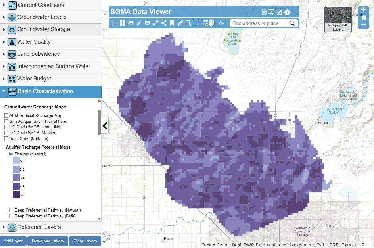
• Aquifer Recharge Potential Maps: locations with relatively higher potential for manager aquifer recharge defined through the Aquifer Recharge Potential mapping process (shown in Figure 3).
• Madera and North Kings Local Investigation Texture Model: depth slices of percent coarse grain material from AEM data combined with lithology log data developed using Data2Texture.
Figure 2: Subsurface Viewer showing
AEM

Numerical Model - C2VSimFG
Datasets, maps, and conceptual models developed through the BC Program can be used to develop or refine numerical groundwater flow models (e.g., DWR’s C2VSimFG).
C2VSimFG simulates the movement of water through the linked land surface, groundwater, and surface water flow systems of California’s Central Valley.
On June 6, 2025, DWR released C2VSimFG Version 1.5, which includes updated monthly historical data for stream inflows, surface water diversions, precipitation, evapotranspiration, land use, and crop water demands.
C2VSimFG Version 1.5 is a major update to Version 1.01, which was released in April 2021, and the model package and accompanying report are available to download from the CNRA Open Data Portal
1 California Department of Water Resources (DWR)
Figure 3: SGMA Data Viewer showing an Aquifer Recharge Potential Map for the Madera and North Kings Local Investigation.
“Join Team GRA,” is an invitation. It’s about showing up and recognizing that progress happens when we work across roles, sectors, and perspectives.
Groundwater management is a team effort—one that requires technical skill, openmindedness, and a healthy dose of creativity. When it comes to sustainable groundwater management, we’re all on the same team!


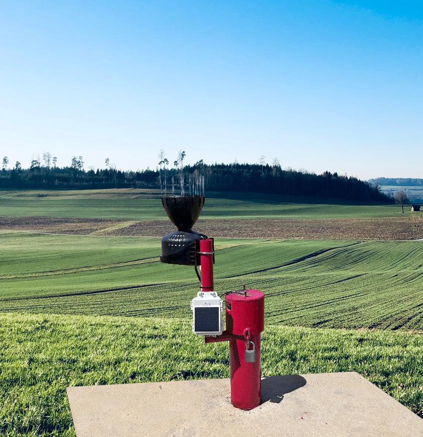
Real-time, reliable monitoring
HOBO MicroRX Station, an easy-to-deploy, lowcost cellular monitoring solution that provides you with precise water level, microclimate and soil conditions data so you can optimize water usage, save money, and maximize yield.
y Access data from anywhere, at any time, via LI-COR Cloud, our innovative cloud software platform
y Get real-time text/email alarm notification so you can react quickly to extreme environmental conditions and leak detections
y Optimize irrigation by using evapotranspiration data and soil moisture monitoring to water only when needed
y Measure water diversions in accordance with Senate Bill 88 SCAN TO LEARN MORE

Hydro Visions

Pfas MeasureMent usinG non-tarGet analysis and susPect screeninG
by John Stults, CDM Smith, Bellevue WA; Stefanie Shea, Woodard & Curran, Andover, MA; Azita Assadi, AECOM, Orange, CA; and Meeta Pannu, Orange County Water District, Anaheim, CA
Introduction
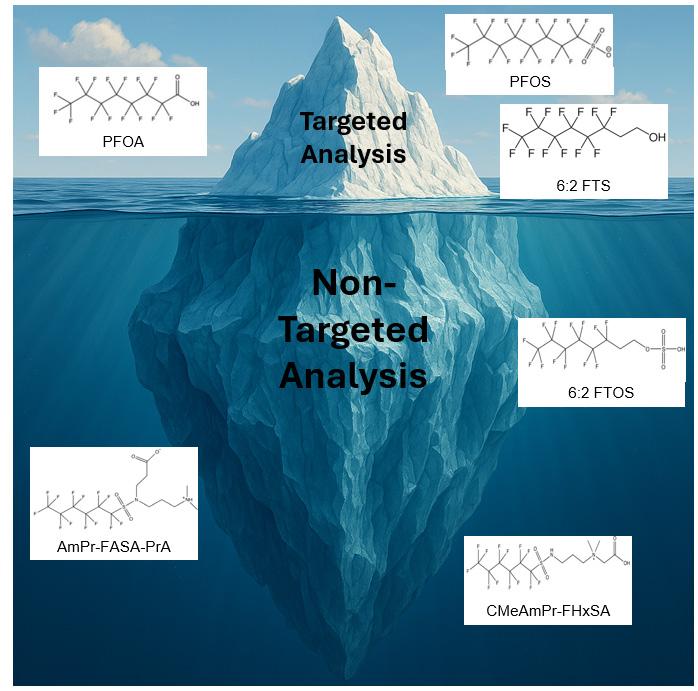
Non-Targeted Analysis (NTA) is an advanced analytical approach to detect and identify unknown or unexpected PFAS compounds in environmental samples.1 Practitioners are usually familiar with targeted analysis, which only measures a predefined list of per- and polyfluoroalkyl substances (PFAS) compounds (e.g., PFOA, PFOS) matched to reference concentrations of laboratory standard compounds and respective internal standards associated with the standard compounds. Conversely, NTA uses highresolution mass spectrometry (HRMS) to screen for a broad array of fluorinated substances, even those that are not yet well-characterized or regulated. NTA can identify several previously unmonitored short-chain, ultra-short-chain PFAS, ethers, as well as cationic/zwitterionic PFAS not typically on target analyte lists.2,3 By combining NTA with targeted analysis, the practitioner gets a much more complete picture of PFAS contamination at the site as conceptually demonstrated in Figure 1. The figure uses an iceberg metaphor to illustrate that targeted PFAS analysis detects only a small portion of compounds, while NTA reveals many more “missing” PFAS hidden below the surface.
NTA is a discovery-based approach that identifies a wide range of unknown organic compounds without prior knowledge of what might be present in water, air, soil, or sediment samples, including both known and novel PFAS. The HRMS analytical method uses advanced algorithms and computational tools to provide semi-quantitative results.4 NTA is most useful in gathering occurrence data on unrelated samples (i.e., different sources).5 Because reference
compounds are not available, a dedicated analyst is required to review the spectral data for each sample to determine what analytes are likely present and the confidence in their presence.
NTA can be broken into two sub-approaches: suspect screening (SS) and true NTA. SS, as part of the broader NTA scope and framework, is a more focused approach that identifies suspected compounds from a predefined library of chemical suspects for which analytical standards do not exist. If offers identification of potential matches and, in
Figure 1: Graphical illustration of the “missing” PFAS (below the surface) mass not captured by target analysis. Target analytes refer to those typically found on EPA 533 or 1633A or common targeted expanded analyte lists.
isions

some cases, semi-quantification based on signal response.4,6 SS is predominantly the non-targeted approach that is commercially available and is used most frequently for PFAS sample analysis. It helps to look for suspected PFAS—ones that might be present in a sample, based on knowledge of their industrial use or chemical structure, but aren’t commonly included in routine targeted testing. SS focusses on specific chemicals with known or predicted molecular formulae and exact masses.4,6 This method is less laborintensive as compared to true NTA, where there is no known molecular structure to look for. Currently, only a select few analytical laboratories (e.g. Battelle, Eurofins, Babcock, and various university labs) offer NTA and SS analysis services. How are NTA and SS Performed
To perform NTA for PFAS, the process begins with a full scan HRMS run, which detects all ionized compounds across a wide mass range. This scan produces thousands of peaks, each representing a potential compound of interest. However, many of these peaks represent background noise, so the peaks must be filtered to identify the true compounds of interest. Each peak is characterized by its accurate mass, retention time, and signal intensity, which are all used to distinguish the real compounds from the noise.
Next, the pared down list of features undergoes SS, where the accurate mass of each feature is compared to a database or library of known PFAS. Features with masses that match the database entries are retained for further evaluation.
Next, the isotopic distribution of each feature is compared to the theoretical isotopic pattern for the proposed molecular formula. A close match increases the confidence in identifying the feature as a compound of interest.
Last, the fragmentation data (MS/MS spectra) of the feature are evaluated via a comparison to a library of spectral fragments. When a sample is analyzed by mass spectrometry, the compounds can be broken into smaller. These fragments can act almost like a fingerprint to help identify the original structure of the compound of interest. If the fragmentation pattern matches a compound in the library, there is higher confidence that the compound in the sample matches one of the non-target compounds of interest. In contrast to SS, true
NTA does not use the databases and libraries of potential compounds. Instead, the molecular formulas and structures of the unknown compounds are postulated using accurate mass, isotopic patterns, and fragmentation spectra.
The use of NTA and SS methods in the legal context of PFAS forensic investigations remains limited, primarily due to the need for further validation and standardization to ensure reliability and acceptance in court. Early applications of NTA and SS show promise in identifying unique “indicator compounds” for forensic identification of a contaminant source(s). Indicator compounds are highly unique PFAS associated with a specific source.
Measurement of PFAS using NTA
When NTA is complete, the compounds identified will have varied levels of identification confidence. For example, if multiple compounds from the same homologous series (i.e., they share the same functional head group but differ in the number of fluorinated carbon atoms) are found in a sample, it increases confidence that those compounds have been correctly identified. One of the challenges in using NTA is communicating confidence in the compounds identified. Guidance documents have been developed to provide a framework for consistently communicating the certainty in non-target identifications, including one from Charbonnet et al. which is PFAS-specific.1 If using NTA, it is recommended that one follows one of these guidance documents to provide additional interpretation to the results.7
article continues on next page
Conclusions
NTA and SS provide value by identifying unique PFAS of interest, supported by a full suite of structural information. This approach is important as targeted methods like EPA 533 and 1633 potentially miss a large amount of organofluorine mass due to the practical considerations around developing suites of thousands of target analytes. The information from NTA and SS has potential use in forensic source tracking and source zone characterization, but these applications are largely unvalidated for current field assessments. NTA and SS analyses are expensive and subjective with interpretation that can not only vary between analytical laboratories but between analysts at a laboratory. It is best to proceed with a cautious approach when using NTA and SS analysis until clearer guidance is established by regulatory agencies or consensus groups. Collaboration between researchers, regulators, and practitioners is essential to refine these tools and expand their utility in PFAS source investigations.
References
(1) Charbonnet, J. A.; McDonough, C. A.; Xiao, F.; Schwichtenberg, T.; Cao, D.; Kaserzon, S.; Thomas, K. V.; Dewapriya, P.; Place, B. J.; Schymanski, E. L.; Field, J. A.; Helbling, D. E.; Higgins, C. P. Communicating Confidence of Per- and Polyfluoroalkyl Substance Identification via High-Resolution Mass Spectrometry. Environ. Sci. Technol. Lett. 2022, 9 (6), 473–481. https://doi.org/10.1021/ acs.estlett.2c00206.
(2) Smith, S. J.; Lauria, M.; Higgins, C. P.; Pennell, K. D.; Blotevogel, J.; Arp, H. P. H. The Need to Include a Fluorine Mass Balance in the Development of Effective Technologies for PFAS Destruction. Environ. Sci. Technol. 2024, 58 (6), 2587–2590. https://doi.org/10.1021/acs. est.3c10617.
(3) Houtz, E. F.; Sedlak, D. L. Oxidative Conversion as a Means of Detecting Precursors to Perfluoroalkyl Acids in Urban Runoff. Environ. Sci. Technol. 2012, 46 (17), 9342–9349. https://doi.org/10.1021/es302274g.
(4) García, R. A.; Chiaia-Hernández, A. C.; Lara-Martin, P. A.; Loos, M.; Hollender, J.; Oetjen, K.; Higgins, C. P.; Field, J. A. Suspect Screening of Hydrocarbon Surfactants in Afffs and Afff-Contaminated Groundwater by High-Resolution Mass Spectrometry. Environmental Science and Technology 2019, 53 (14), 8068–8077. https:// doi.org/10.1021/acs.est.9b01895.
(5) Benotti, M. J.; Fernandez, L. A.; Peaslee, G. F.; Douglas, G. S.; Uhler, A. D.; Emsbo-Mattingly, S. A Forensic Approach for Distinguishing PFAS Materials. Environmental Forensics 2020, 21 (3–4), 319–333. https://doi.org/10.108 0/15275922.2020.1771631.
(6) Benjamin Place. Suspect List of Possible Per- and Polyfluoroalkyl Substances (PFAS), 2021, 3 files, 1.09 MB. https://doi.org/10.18434/MDS2-2387.
(7) Hollender, J.; Schymanski, E. L.; Ahrens, L.; Alygizakis, N.; Béen, F.; Bijlsma, L.; Brunner, A. M.; Celma, A.; Fildier, A.; Fu, Q.; Gago-Ferrero, P.; Gil-Solsona, R.; Haglund, P.; Hansen, M.; Kaserzon, S.; Kruve, A.; Lamoree, M.; Margoum, C.; Meijer, J.; Merel, S.; Rauert, C.; Rostkowski, P.; Samanipour, S.; Schulze, B.; Schulze, T.; Singh, R. R.; Slobodnik, J.; Steininger-Mairinger, T.; Thomaidis, N. S.; Togola, A.; Vorkamp, K.; Vulliet, E.; Zhu, L.; Krauss, M. NORMAN Guidance on Suspect and Non-Target Screening in Environmental Monitoring. Environ Sci Eur 2023, 35 (1), 75. https://doi.org/10.1186/s12302-023-00779-4.

Æ
Æ
Æ
Æ
Hydro Visions
ManaGed aquifer recHarGe considerations for cV-salts
by Kjia Rivers, Senior Policy Advocate, Community Water Center
Approximately 85% of Californians depend on groundwater for some portion of their water needs1, including drinking and irrigation waters. This condition is especially true in the Central Valley and on the Central Coast where communities depend on shallow domestic wells that are threatened by dropping groundwater levels and increasing water quality contamination. In partnership, Community Water Center (CWC) works alongside directly impacted communities which face contaminated water or no running water at all. CWC advocates with communities to develop recommendations to enhance policies and programs to protect drinking water.
California made the historic move to protect drinking water by passing the Human Right to Water in 2012 –which declares that everyone has the right to safe, clean, and affordable drinking water. The State then passed the Sustainable Groundwater Management Act (SGMA) in 2014 – moving the Human Right to Water forward by protecting groundwater for everyone. Under SGMA, groundwater sustainability agencies (GSAs) are required to balance water budgets, prevent undesirable results, and consider all beneficial users and uses.
Many GSAs are looking to implement managed aquifer recharge (MAR) projects to increase groundwater quantity and to potentially dilute contaminated groundwater. Although MAR can provide potential benefits, MAR projects can push contaminants found in the soil into the groundwater and mobilize contaminant plumes towards sources of drinking water further endangering drinking water quality.
GSAs are not the only agencies who plan to use MAR to meet groundwater sustainability. Under the Central Valley Salinity Alternatives for Long-Term Sustainability (CV-SALTS) Program, Management Zones may use MAR to meet the Program’s objectives of addressing nitrate contamination, which include restoring groundwater basins and ensuring safe drinking water supply.
While MAR projects can mitigate high nitrate concentrations in the Central Valley through dilution, without caution, MAR projects can also worsen groundwater quality. Because of this potential, it is important that Management Zones use best practices when developing and coordinating on recharge projects in order to protect drinking water quality from further degradation and to promote basin restoration.
1. Management Zones must prioritize nitrate reductions.
To best restore our groundwater basins, we need to protect our existing groundwater proactively and ensure that communities have safe drinking water. Nitrate has persisted in our environment for decades. Even if growers stop contributing to nitrate contamination today, it will take decades to see reductions in nitrate contamination. Specifically, “Traditional pump and treat and in-place approaches to remediation, common for localized industrial contamination plumes, would cost billions of dollars over many decades to remove nitrate from groundwater in the Tulare Lake Basin and Salinas Valley.”2 Because of this high cost and timeframe, it is crucial that Management Zones prioritize nitrate discharge reductions now in order to make real progress towards basin restoration
2. Management Zones must conduct mapping to ensure recharge projects do not further degrade groundwater quality.
isions
It is crucial that Management Zones implement the best practices as they implement MAR projects and coordinate with other local agencies on MAR projects in order to successfully meet the objectives of CV-SALTS. For example, Management Zones should conduct mapping to best understand where MAR may worsen or improve nitrate contamination in order to further progress towards basin restoration. Management Zones should identify nearby land uses to prevent further exacerbating nitrate contamination by conducting MAR. Some crops and agricultural practices, such as dairies, present a high risk of loading nitrate in the soil which can then be flushed into the groundwater. Because of this high risk, local agencies should prohibit recharge on dairy lands, especially near communities.
3. Management Zones must conduct monitoring to track changes in contamination.
Groundwater quality monitoring is essential for Management Zones to meet CV-SALTS objectives – especially as they implement and coordinate on MAR. It is important to understand if MAR projects are diluting or increasing nitrate concentrations especially around communities. If monitoring wells do not already exist near a recharge site, Management Zones should establish monitoring wells at recharge sites to have access to real time monitoring data.3
4. Management Zones must ensure recharge projects feature drinking water mitigation strategies.
Management Zones should use monitoring to identify where communities no longer have a safe drinking water supply and then ensure they are meeting the CV-SALTS requirement to provide nitrate impacted communities with safe drinking water. Monitoring can be used as a tool to identify if drinking water mitigation is needed in scenarios where MAR projects increase nitrate contamination. If recharge projects increase nitrate contamination in communities’ drinking water sources, Management Zones should deploy bottled water to impacted communities in the short term, continue monitoring, and determine the long-term solution(s) to address the contamination.4
References:
1 California Department of Water Resources statement dated October 7, 2024. https://water.ca.gov/News/News-Releases/2024/ Oct-24/DWR-Releases-Groundwater-Conditions-Update-Highlighting-First-Decade-of-SGMA#:~:text=Nearly%2085%20percent%20of%20Californians,of%20 sight%2C%20beneath%20our%20feet.
2 UC Agriculture and Natural Resources, Addressing Nitrate in California’s Drinking Water With a Focus on Tulare Lake Basin and Salinas Valley Groundwater, pg. 5. Available at: https://ucanr.edu/sites/default/ files/2012-03/138956.pdf
3 Community Water Center et. al, Managed Aquifer Recharge Policy Recommendations, pg. 4. Available at: https://static1.squarespace.com/static/5e83c5f78f0db40cb837cfb5/t/680679d0f8aa923d2b35c07e/174525 4866690/ Recharge_Policy_04.14.25.pdf
4 Community Water Center et. al, Managed Aquifer Recharge Policy Recommendations, pg. 5. Available at: https://static1.squarespace.com/static/5e83c5f78f0db40cb837cfb5/t/680679d0f8aa923d2b35c07e/174525 4866690/ Recharge_Policy_04.14.25.pdf
Hydro Visions

Hello froM tHe dei coMMittee and welcoMe to our new coluMn!
by the GRA DEI Committee
Since 2020, GRA’s Diversity, Equity & Inclusion (DEI) Committee has worked to ensure that all voices have a seat at the table in California’s groundwater conversations. Our mission is to advance DEI within GRA and the broader water community by evaluating current practices, improving representation, and creating inclusive strategies for events, outreach, and leadership.
We are excited to launch this new column, a space to share stories and uplift diverse perspectives that shape the groundwater landscape in California.
Our Purpose and Progress:
In forming our committee, we asked: Who is represented in the water industry? Whose voices are not being heard? These questions continue to guide our work.
Each year, the DEI Committee leads efforts to:
• Support community access to the Western Groundwater Congress (WGC), GRA’s annual meeting, by coordinating scholarship fundraising, selection, and distribution.
• Collaborate across GRA branches and events to ensure diverse representation among speakers and participants.
• Uplift voices from across California by featuring community stories and reflections at our monthly meetings and through this column.
How the DEI Committee started:
To understand where we are going, it is important to reflect on how this work began. Part of the original DEI task force, John McHugh, shares the following reflection on the formation of the DEI Committee and our early milestones:
“The DEI task force was born after the tumultuous summer of 2020 (George Floyd’s murder and subsequent protests). Abigail Madrone, John McHugh, Steve Phillips and Sarah Erck were the original DEI task force, later elevated into a committee by the Board on August 14, 2020. In the early days, the committee discussed how to integrate DEI into GRA. We also shared online and printed resources (e.g., White Fragility). GRA kicked off the 2021 Western Groundwater Congress, with a panel discussion Making Ripples That Lead to Waves - Initiating Diversity, Equity, and Inclusion Programs in the Water Industry. The panel chairs, Abigail Madrone and Lyndsey Bloxom, were at the forefront of GRA’s DEI leadership at the time. Lyndsy was the WGC Chair and in 2022 the Board of Directors made her GRA’s first DEI Officer.
GRA was taking steps to raise awareness, be inclusive and consistent with its vision, “Sustainable Groundwater for All”.”
A Look Back at January 2025:
Earlier this year, the DEI Committee participated in GRA 101, a webcast series designed to introduce members to different GRA committees and initiatives. We shared our committee’s charter, discussed our goals, and invited others to get involved. You can view the recorded webcast on GRA’s website or reach out to us to learn more.
isions

What is Coming in 2025:
In future issues of HydroVisions, we’ll be sharing:
• Interviews with professionals, community members, and leaders working in DEI spaces in the water sector.
• Reflections and stories from WGC scholarship recipients.
• Reflections and stories from DEI Committee Members.
Join Us
Would you like to be part of this effort?
We are always looking for new voices and new ideas. Email staff@grac.org to join our committee, share a story, or suggest a topic for this column. Whether you are a student, professional, or someone passionate about water access, we welcome you.
Thank You for reading!
The DEI Committee of the Groundwater Resources Association of California

With offices in Sacramento, Oakland, Monterey, San Luis Obispo, and Pasadena, we specialize in:
more information, visit our website or contact:


Hydro Visions

HiGHliGHts froM tHe 2024 conteMPorary
Groundwater issues council worksHoP
by
Abhishek Singh, INTERA; Erik Cadaret, Yolo County Flood Control & Water Conservation District; Thomas Harter, UC Davis; Vicki Kretsinger, Luhdorff & Scalmanini; Tim Parker, Parker Groundwater; Dave M. Ceppos, DMC Public Policy Mediation and Facilitation
Since 2011, GRA’s Contemporary Groundwater Issues Council (CGIC) has united California’s top groundwater experts to tackle key policy, technical, and regulatory challenges. The CGIC offers a transparent forum to guide the Groundwater Resources Association (GRA) in supporting groundwater stakeholders through events and education. The 14th CGIC workshop, held October 25, 2024, at UC Davis, marked SGMA’s 10th anniversary. Titled “SGMA and the Burden of Legacy,” the CGIC examined managing legacy and ongoing groundwater issues, focusing on quality and land subsidence challenges. The workshop emphasized cross-agency coordination and practical strategies to address past, present, and future groundwater concerns statewide.
Workshop participants included over 45 leaders from State agencies, water districts, water management entities, groundwater sustainability agencies, non-profit organizations (NGO), academia, research laboratories, consulting firms from across the state, and several GRA Board and Executive Members. The full-day workshop was split into two sessions: a moderated panel followed by a roundtable discussion during the morning, and breakout sessions focusing on key topics and themes during the afternoon. The morning panel, moderated by GRA Board Director, Dave Ceppos (DMC, Public Policy Mediation and Facilitation), included diverse perspectives from State and local agencies – Mr. Paul Gosselin, (Deputy Director, Sustainable Groundwater Management, California Department of Water Resources), Ms. Natalie Stork (Director, Office of Sustainable Groundwater Management, State Water Resources Control Board), Mr. Patrick Pulupa,
(Executive Officer, California Regional Water Quality Control Board – Central Valley Region), Ms. Stephanie Anagnoson (Director of Water and Natural Resources, Madera County), Ms. Tess Dunham (Attorney, Kahn, Soares & Conway), and Mr. Aaron Fukuda (General Manager, Tulare Irrigation District & Mid-Kaweah GSA). The panel highlighted how past land use and water management have led to longstanding groundwater challenges (e.g., nitrate pollution, land subsidence). The panelists emphasized the need for forwardthinking innovation and stewardship with coordination across multiple jurisdictions. Key issues include data gaps, high monitoring costs, governance fragmentation, and legacy inequities. SGMA offers a path forward but requires better coordination, funding, and education. Stopping groundwater level decline is critical. By 2065, success depends on better monitoring and management datasets and tools, coordination across GSAs and subbasins, equitable water allocations, land repurposing, and shared responsibility across agriculture, communities, and government for a sustainable and just water future.
The afternoon consisted of two breakout groups, one each for Water Quality and Land Subsidence. The Water Quality group emphasized urgent action on nitrate contamination in disadvantaged communities despite funding challenges, stressing affordability, coordination among agencies, and linking SGMA with water quality management. Immediate solutions, better data, and addressing emerging contaminants are needed, while Managed Aquifer Recharge is explored cautiously due to metal mobilization concerns. The Land Subsidence group focused on minimizing subsidence through local and regional management, improved monitoring, demand management, and recharge strategies. Clearer state roles, historic data improvements, and regional coordination groups are required to address residual subsidence and
isions

infrastructure impacts, promoting collaboration among agencies, growers, and experts.
The workshop ended with a call for unified efforts across state, regional, and local agencies to address the ongoing challenges associated with groundwater quality and subsidence. GRA can play a key role by providing education, policy leadership, and a platform for innovation. Strategic recommendations for GRA were to facilitate cross-agency dialogue on nitrate and salinity management; promote best practices in monitoring and data transparency; support mitigation strategies and public education on water quality; coordinate outreach around new DWR BMPs on subsidence; and advocate for long-term funding strategies, including water-related general funds.
As CGIC continues its role as a “think tank” for groundwater in California, this workshop reinforced the need to balance urgency with foresight, ensuring groundwater management addresses both immediate public health risks and long-term sustainability.

Hydro Visions

GeoH2oMysteryPix
by Chris Bonds - DWR, Sacramento Branch Member at Large
GeoH2OMysteryPix is a fun addition to HydroVisions that started in Fall 2022, so over 2-1/2 years now. The idea is simple; I provide one or more photograph(s) and two questions, along with a hint, and HydroVisions’ readers email in their guesses.
In a future issue of HydroVisions, I will share the answer(s) along with some brief background/historical information about the photos and acknowledge the first person(s) to email me the correct answer(s).
GRA looks forward to your continued participation in GeoH2OMysteryPix.
SPRING 2025 ANSWERS
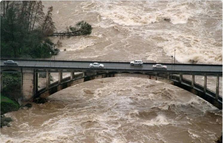
What is this? Where is it Located?
Hint: A significant event during Water Year 1997 in northern California.
Congratulations to Trevor Pontifex, PG, Hydrogeologist, Montgomery & Associates for providing the following correct response to the Spring 2025 GeoH2OMysteryPix Questions:
“That’s Rainbow Bridge in Folsom, where the American River enters Lake Natoma.”
Background/History: The above Sacramento Bee photograph shows the American River raging under the Rainbow Bridge in Folsom on January 2, 1997. As the calendar turned from 1996 to 1997, a series of intense “pineapple express”-style storms walloped Northern California, setting rain records at the time in communities from Shasta down to Fresno. These intense storms are now commonly referred to as Atmospheric Rivers or ARs (Figure 1).
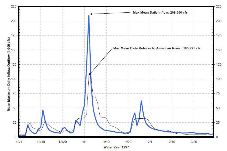
The Sierra Nevada received up to 30 inches of rain, with temperatures above freezing up to 9,000 feet - which caused rapid runoff and widespread flooding. Figures 2 and 3 show the remarkable hydrographs of daily storage and precipitation and inflow into Folsom Lake and outflow to Lake Natoma (and the American River) in Water Year 1997.
In the end, the deadly flooding devastated Northern and Central California with over 300 square miles of flooding and forced 48 of 58 counties to be declared disaster areas with more than a billion dollars in economic loss. Floodwater impacted over 23,000 homes and 2,000 businesses.
isions


References:
DWR 2017. Bulletin 69-97: High Water in California.
DWR 2021. 1997 New Year’s Floods in NorCal. A Photo Essay: https://storymaps.arcgis.com/ stories/d22efa91bc034895bcf3f0bafec177f8
USGS 1999. Floods in Northern California. Fact Sheet FS-073-99
SUMMER 2025 QUESTIONS
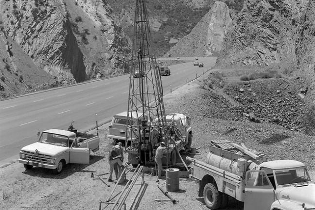

What is this? Where is it Located?
Hint: A world-class sedimentary basin in southern CA within which there lies a significant water storage facility named after a unique nearby geographic feature.
Think you know What this is and Where it is Located? Email your guesses to Chris Bonds at goldbondwater@gmail.com
Figure 1. Diagram of an Atmospheric River directed towards Northern and Central California. NOAA.
Figure 2. Daily Storage in Folsom Lake and Daily Precipitation at Blue Canyon
Figure 3. Mean Daily Inflow into Folsom Lake and Outflow to Lake Natoma (American River).
Hydro Visions

PartinG sHot
by John Karachewski, PhD
Southward view across the Klamath River watershed, Siskiyou Mountains, and Mount Shasta (background upper left and below clouds) near the California-Oregon border.
The headwaters of the Klamath River are in the Cascade Range of southern Oregon. The river flows southwesterly through the Siskiyou Mountains to the Pacific Ocean south of Crescent City, California. The watershed encompasses 12,000 square miles and the river is approximately 263 miles in length.
The Siskiyou Mountains are the northernmost and largest subrange of the Klamath Mountains. Although the Siskiyou Mountains are generally lower in elevation, their steep topography and proximity to the Pacific Ocean, results in significant precipitation, including wintertime snow on the peaks. Western canyons can receive over 100 inches of rain in stormy winters and are densely forested, while eastern areas are more arid. The varied topography and climate contribute to high biodiversity and endemic species.
The Klamath River salmon runs were once the third largest on the West Coast but have fallen to just eight percent of their historic numbers. Chinook and coho salmon, steelhead and coastal cutthroat trout, green and white sturgeon, and Pacific lamprey all rely on a healthy Klamath River. The river has been home to indigenous people for thousands of years and tribes including the Yurok, Karuk, Hoopa, Shasta, and Klamath rely on, and care for, the river today.
The Ashland Pluton is composed primarily of granite, granodiorite, and diorite. The pluton intruded into the accreted terranes of the western Paleozoic and Triassic belt approximately 161 million years ago during the Jurassic Period.
Photographed near the summit of the Mount Ashland Ski Area, Oregon by John A. Karachewski, PhD, on May 26, 2025. Mount Ashland (7,532 feet) is the tallest mountain in Oregon, west of the Cascade Range. This area is located about 6 miles north of the OregonCalifornia border. Mount Ashland offers outdoor recreation ranging from summertime hiking and biking to skiing, snowboarding, and snow shoeing in the winter. The approximate GPS coordinates of the photograph are 42.080694° and -122.717139°.




compliance with smart solutions that adapt to the


YOUR PARTNER IN WATER TRADING
evolving groundwater management landscape.

AGILE WELL REGISTRATION


TRANSPARENT WATER ACCOUNTING
SHAREABLE WATER ACCOUNT ACCESS
ADMINISTRATIVE TOOLS


t H ank y ou to o ur c ontributors
Craig Altare, PG, is a Supervising Engineering Geologist and leads the Modeling and Tools Support Section, which develops and maintains the fine-grid version of the California Central Valley Groundwater-Surface Water Simulation Model (C2VSimFG) and supports implementation of the Sustainable Groundwater Management Act through the development of technical guidance for Groundwater Sustainability Agencies. Craig holds degrees in geology from Virginia Tech and hydrology from New Mexico Tech.
Azita Assadi, P.Geo. is a technical committee member at the GRAC. She is a Hydrogeologist with over 20 years of consulting experience in water resources and soil/groundwater management in the US, Canada, and internationally. She is currently working as a Environmental Project Manager/Geologist at AECOM in the field of subsurface investigation and water resources management.
Ben Brezing, PE, is a Supervising Water Resources Engineer and leads the Data Support Section that maintains the Online System for Well Completion Reports (OSWCR), the California Statewide Groundwater Elevation Monitoring (CASGEM) application, the SGMA Monitoring Network Module, SGMA Data Viewer, California's Groundwater Live, and SGMO’s datasets on California Natural Resources Agency’s Open Data Portal. Ben holds a master’s degree in Geophysics from the University of Hamburg, Germany.
Chris Bonds is a Senior Engineering Geologist (Specialist) with the California Department of Water Resources (DWR) in Sacramento. Since 2001, he has been involved in a variety of statewide projects including groundwater exploration, management, monitoring, modeling, policy, research, and water transfers. Chris has over 31 years of professional work experience in the private and public sectors in California, Hawaii, and Alaska and is a Professional Geologist and Certified Hydrogeologist. He received two Geology degrees from California State Universities. Chris has been a member of GRAC since 2010, a Sacramento Branch Officer since 2017, and has presented at numerous GRAC events since 2004.
Erik Cadaret is an Associate Geologist with West Yost Associates and joined the GRA Board of Directors in 2021. Erik’s role with West Yost is to support various groundwater technical projects for clients within the state of California, management of a GSA in northern California, and support business development efforts to engage new clients. What Erik loves the most about his job is the interpersonal interaction with clients to help find creative solutions to meet their needs. Erik loves being a part of GRA because it provides an outlet to collaborate with some of the greatest minds in groundwater. Erik also loves to geek out on techy, innovative ideas that may significantly benefit the water industry in achieving sustainable groundwater for all.
Dave M. Ceppos, DMC Public Policy Mediation and Facilitation, is the Program Manager for stakeholder and mediation efforts on numerous water quality efforts including several Total Maximum Daily Load cases, Irrigated Lands Regulatory Programs, and nutrient management programs. Similarly he is the facilitator and governance adviser to the Delta Regional Monitoring Program.
Dr. Katherine Dlubac, PG, is a Senior Engineering Geologist and the Project Manager for the Statewide Airborne Electromagnetic (AEM) Surveys and the Basin Characterization Program. In this role, Katherine defines project tasks and oversees all project work, including data collection and analyses, and the development of tools, maps, and models. Katherine engages in coordination with local, state, and federal agencies and ensures timely data publication and visualization. Katherine supports the implementation of the SGMA and contributes to DWR’s California Water Plan and California’s Groundwater Bulletin 118 publications. Katherine holds degrees in Geophysics from Stanford University with a focus on using geophysical data to characterize groundwater aquifers.
Thomas Harter holds the Nora S. Gustavsson Endowed Professorship for Groundwater Resources in Agriculture at the University of California, Davis, leading a unique research and outreach program on sustainability of groundwater resources in agriculture.
John Karachewski, PhD, retired recently from the California-EPA in Berkeley after serving as geologist for many years in the Geological Support Branch of the Permitting & Corrective Action Division for Hazardous Waste Management. John has conducted geology and environmental projects from Colorado to Alaska to Midway Island and throughout California. He leads numerous geology field trips for the Field Institute and also enjoys teaching at Diablo Valley College. John enjoys photographing landscapes during the magic light of sunrise and sunset. Since 2009, John has written quarterly photo essays for Hydrovisions.
Christy Swindling Kennedy, PE, PG, CHG, is a hydrogeologist, water resources engineer, and strategy lead for Woodard & Curran. She has served in numerous roles such as engineering, operations, people leadership, and was the CMO for RMC Water
& Environment. She has over 20 years in the consulting engineering business focused on water management and resiliency. With her technical background in hydrogeology and water resources engineering coupled with her business development expertise, she serves as an advisor to a water industry-focused accelerator and two venture funds.
Vicki Kretsinger, President at Luhdorff & Scalmanini. Vicki has more than 30 years of experience in regional groundwater resource management and quality assessments, including groundwater supply sufficiency and availability assessments, design of monitoring networks and programs, long-term groundwater quality monitoring and protection programs for twelve agricultural coalitions in the Central Valley, and groundwater technical assistance to the Central Valley Salinity Coalition since 2009.
Amanda Ott, P.E., is a Senior Water Resources Engineer with the Data Support Section. She has a master’s degree in civil engineering with a focus on Water Resources from UC Davis. She has been with SGMO since 2019 and works mainly on data access and technical support for projects like Basin Characterization, California’s Groundwater Update Bulletin 118, the SGMA Data Viewer, and California’s Groundwater Live website.
Manmeet “Meeta” Pannu, PhD, is a Senior Scientist in the Research and Development (R&D) Department of Orange County Water District (OCWD) at Anaheim, CA. Meeta is currently completing research at OCWD related to PFAS. These projects include evaluation of GAC, IX, and alternative adsorbents to remove PFAS from groundwater during wellhead treatment and managed aquifer recharge via in situ adsorption and alternative methods to measure total PFAS in water samples.
Timothy Parker, PG, CHg with Ramboll and lead reviewer for AEM Project, Tim is a Principal with Parker Groundwater in Sacramento, where his current practice focuses on strategic water resources planning and policy consulting, groundwater management planning and program implementation, and groundwater resources development.
Kjia Rivers (she/her), Senior Policy Advocate At CWC, Kjia Rivers works on drought, nitrate, and climate change related drinking water issues. Originally from San Diego, Kjia attended the University of California, Santa Barbara to obtain her Bachelor of Arts in Environmental Studies and Political Science. During her time at UCSB, she learned about environmental justice issues and how vulnerable communities are often left out of the policy making process.
Stefanie Shea, Ph.D., is a Technical Manager at Woodard and Curran. Her work is primarily focused on PFAS fate and transport in the environment as well as PFAS remediation and other environmental contaminants.
Dr. Abhishek Singh is a Principal Engineer with more than 20 years of experience and is President of INTERA’s Water Resources & Supply Line of Business (LoB), where he leads and manages operations, business development, strategic planning for the lob across the United States. He has authored several technical publications and journal articles on groundwater modeling and calibration, stochastic optimization techniques, uncertainty and risk analysis, climate change, and emerging contaminants. Dr. Singh is also the chair of the GRA technical committee and serves on the GRA board of directors.
Steven Springhorn, PG, is a Supervising Engineering Geologist and leads the Technical Assistance Section. With nearly two decades of experience at DWR, Steven leads technical assistance and aquifer characterization efforts to support the implementation of SGMA and oversees activities related to California’s Groundwater Bulletin 118, the state’s official compendium of groundwater information. His expertise spans groundwater monitoring, management, and data publication, with a strong focus on integrating technical and policy solutions for long-term water sustainability. Throughout his career, Steven has worked across multiple DWR offices, contributing to strategic planning, oversight, and assistance programs that advance sustainable groundwater management.
John Stults, Ph.D., is an Environmental Engineer with CDM Smith located in Bellevue Research & Testing Laboratory. He completed his PhD research at Colorado School of Mines, studying the transport mechanisms of PFAS in the vadose zone. He specializes in PFAS transport and treatment assessments, numerical modelling, and scalable data analytics.
Michelle Zhang is a Water Resources Engineer in the Data Support Section. She provides support to data visualization of Statewide Airborne Electromagnetic Survey and Basin Characterization Program data as well as to the Online System for Well Completion Reports and California’s Groundwater Live. Michelle holds degrees in civil engineering from Columbia University and sustainable water engineering from UCLA.

CORPORATE SPONSORS
EVENT SPONSORS


Roscoe Moss Company

