DRAFT

9.13 Development in the Vicinity of Heritage Items and Heritage Conservation Areas 62
9.13.1 Development in the Vicinity of Heritage Items 62
9.13.2 Development in the Vicinity of Heritage Conservation Areas 62

9.13 Development in the Vicinity of Heritage Items and Heritage Conservation Areas 62
9.13.1 Development in the Vicinity of Heritage Items 62
9.13.2 Development in the Vicinity of Heritage Conservation Areas 62
This Part of the DCP applies to Aboriginal cultural heritage, historical archaeology, listed heritage items, heritage conservation areas, and places in the vicinity of heritage items and heritage conservation areas.
Heritage includes places and objects that have a sense of living history and that offer physical links that connect the community to earlier generations and their way of life.
The Darug and GuriNgai peoples were the original inhabitants of Hornsby Shire. Significant remnants of Aboriginal culture remain as evidence of their occupation.
Guidelines addressing design, streetscapes, siting, garages, carports, fences, gates, and landscaping assist conserve the heritage significance of the natural and built environment and ensure new development is sympathetic with identified heritage values. These guidelines are not intended to prevent development but rather ensure that change takes place in a way that does not detract from the significance of cultural heritage places.
9.1.1
This part aims to provide direction and guidance for the development of heritage items and properties located withinheritageconservationareasandwithinthevicinity of heritage items and places in Hornsby Shire.
The heritage controls have the following overarching aims and objectives:
a. To retain and conserve the environmental heritage of Hornsby Shire, including places of Aboriginal cultural heritage, heritage items, archaeological sites, and heritage conservation areas.
b. To ensure the heritage significance, fabric, and setting of heritage items and heritage conservation areas are conserved.
c. To ensure development in the vicinity of heritage items and heritage conservation areas respects the heritage item or place.
9.1.2
This part applies to any development that is:
a place of known or potential Aboriginal cultural heritage
a heritage item or archaeological site listed under Schedule 5 of the Hornsby Local Environmental Plan 2013
located within a heritage conservation area
in the vicinity of a heritage item or heritage conservation area
9.1.3
NSW Legislation
Guiding Heritage Documents
Key documents to assist with compliance, managing cultural heritage places, and assessing heritage significance in NSW include:
HeritageCompliancePolicy(2024) (Department of Climate Change, Energy, and the Environment)
Assessing Heritage Significance: Guidelines for AssessingPlacesandObjectsagainsttheHeritage Council of NSW Criteria (2023) (Department of Planning and Environment)
In NSW, items of heritage significance and archaeological remains (referred to as ‘relics’) are afforded statutory protection under the following legislation:
the HeritageAct1977(NSW) (the Heritage Act)
theNationalParksandWildlifeAct1974(NSW)(the NPWS Act)
the EnvironmentalPlanningandAssessmentAct 1979(NSW) (the EPA Act)
TheBurraCharter:TheAustraliaICOMOSCharter forPlacesofCulturalSignificance(2013)
Design Guide for Heritage (2023) (Department of Planning and Environment)
Connecting with Country Framework (2024) (Department of Planning and Environment)
DesigninContext(2005) (NSW Heritage Office)
BetterPlaced–DesignGuideforHeritage (2019) (Heritage Council of NSW)
HLEP 2013
Clause 5.10—Heritage Conservation of the HLEP provides the objectives and requirements for the management of heritage items and archaeological sites in the LGA, including the ability for Council to request a heritage management document for proposed developments involving heritage items and places. The HLEP 2013 contains a list of environmental heritage items referred to as Schedule 5.
Note:
To view Schedule 5 of the HLEP 2013 refer to: https://legislation.nsw.gov.au/view/html/inforce/current/epi2013-0569#sch.5
HDCP 2024
This partofthe HDCPshouldbe read inconjunction with the other relevant parts of the HDCP. Where there is inconsistency between the provisions in Chapter 9 and in other parts of the HDCP, the provisions in Chapter 9 should prevail.
Hornsby Shire contains the following types of heritage items and places of significance:
Aboriginal heritage items and places of Aboriginal cultural heritage
Archaeological heritage items
Built heritage items, including houses, residential flat buildings, shops, churches, schools, monuments, commercial buildings, civic buildings etc
Landscape heritage items, including natural landscapes, cultural landscapes, gardens, parks, trees, cemeteries, and memorials
Heritage Conservation Areas
Note:
For further information about the types of heritage and definition of heritage in Hornsby, refer to Council’s website: www.hornsby.nsw.gov.au/property/build/heritage
Detailed information about the submission requirements for heritage management documents can be found on Council’s website.
Work to State significant heritage items may be integrated development requiring an approval under Section 60 of the Heritage Act.
Heritage Management Documents
A heritage management document is a report that identifies the heritage significance of a place and assesses the impact a proposed development would have on that significance.
A heritage management document is required to be submitted with a Development Application for works to:
a heritage item,
Note:
The information required will depend on the heritage significance of the property, the contribution of the property to a heritage conservation area (if relevant), and the nature and scope of the development proposed.
Heritage Impact Statements
Development applications for heritage items and properties located within heritage conservation areas require a Heritage Impact Statement (HIS) or Statement of Heritage Impact (SOHI). The HIS should follow the “Guidelines for preparing a statement of heritage impact” published by the NSW Department of Planning and, at a minimum, address:
on land adjacent to a heritage item, or
in the vicinity of a heritage item, or
within a heritage conservation area
Council may require any of the following heritage management documents:
Heritage Impact Statement (HIS)
Heritage Landscape Plan
Schedule of Conservation Works (SoCW)
Conservation Management Plan (CMP)
Schedule of materials, colours, and finishes
Curtilage Study
theidentifiedheritagesignificanceoftheplace(use heritage manual criteria and state heritage inventory datasheet),
an overview of the historical development of the site,
the effects of the proposal on the significance of the place and its setting, and
the heritage requirements of the HLEP and HDCP.
Notes:
For further information about the DA submission requirements for heritage items and places, refer to: https://www.hornsby.nsw.gov.au/__data/assets/pdf_file/0020/ 271190/DA-Submission-Guideline-2013.pdf
For further information, refer to the Department of Planning and Environment website: https://www.environment.nsw.gov.au/
Detailed guidelines on preparing Heritage Impact Statements can be found at: https://www.environment.nsw.gov.au//media/OEH/Corporate-Site/Documents/Heritage/guidelinesfor-preparing-a-statement-of-heritage-impact-230201.pdf
A Heritage Landscape Plan may be required if the property has significance for its landscape values, including private gardens. A qualified consultant should be engaged to prepare the Heritage Landscape Plan.
Development Applications for a heritage item that is in need of repair, conservation or maintenance works to the significant fabric of the item should be accompanied by a Schedule of Conservation Works (SoCW). The SoCW should be prepared by an experienced heritage consultant.
Conservation Management Plans (CMPs) are required for changes to State significant heritage items or large heritage sites such as schools and churches. A CMP is not usually required for a locally listed heritage item unless substantial redevelopment is proposed. A CMP
should be prepared by a qualified heritage consultant in accordance with published guidelines.
Heritage Asset Action Plan
Heritage AssetAction Plans (HAAPs) may be required to provide guidance for the management and maintenance of a heritage item and conservation approach when significant change or development affecting an item is proposed.
Note:
For furtherinformationon Heritage Asset Action Plans, referto theStatementofBestPracticeforHeritageAssetActionPlans: https://www.environment.nsw.gov.au//media/OEH/Corporate-Site/Documents/Heritage/statementof-best-practice-heritage-asset-action-plans-2021.pdf
Schedule of Materials, Colours, and Finishes
Development Applications for works to a heritage item or property within a heritage conservation area require a schedule of materials and details of the colour scheme and finishes.
Curtilage Study
For development applications that propose subdivision, a curtilage study should be provided and an assessment of the impacts of the proposal on the curtilage of the heritage item or heritage conservation area.
Some minor works or maintenance may be able to be undertaken to a heritage-listed property or a property located within a heritage conservation area without development consent. However, written advice from Council confirming an exemption must be obtained prior to any works commencing.
General
a. Pursuant to Clause 5.10(3) of the HLEP, development consent may not be required for work to a heritage item or heritage conservation area if Council is satisfied the proposed development:
c. For the purposes of Clause 5.10(3) of the HLEP, the followingminormaintenanceworksmaynotrequire consent:
resealing/treating timber
replacing broken windows
re-hanging doors or gates
replacing or establishing gutters and downpipes
re-pointing brickwork
restoring posts or fence posts
repairing stonework and plasterwork
underpinning and damp proofing
is of a minor nature, or is for the maintenance of the heritage item, archaeological site, or a building, work, relic, tree or place within a heritage conservation area; and
would not adversely affect the significance of the heritage item, archaeological site or heritage conservation area.
b. Written advice has been received from Council prior to commencement of works.
replacing plumbing and wiring
general maintenance of heritage gardens (pruning or replanting original species)
d. Replacing external materials such as roofs, verandah balustrades, exterior cladding or front fences with like materials. However, details of such works must be submitted to Council, seeking confirmation in writing that development consent is not required.
e. Repainting surfaces other than items on the State Heritage Register may not require development consent. Colours must be in keeping with the heritage significance or style of the property or heritage conservation area.
Notes:
Replacing original materials with modern materials which are not ofa similar style, type,colour, andprofile is not minor work and will require development consent.
Painting previously unpainted surfaces requires development consent from Council.
A request for advice on whether works to a heritage item or within a heritage conservation area can be carried out without development consent can be submitted through Council's Online Services Portal. There is no fee for requesting heritage exemption advice.
The submission of comprehensive information with the request will assist in Council’s assessment of your proposal. At a minimum, a statement describing the proposed works and photographs should be supplied. Other information such as plans, schedule of colours, materials, construction details, and tree location should be supplied if relevant to the proposed works.
Notes:
To access Council’s Online Services Portal, refer to: HSC Online Services Portal (infor.com)
Some minor developments are permissible on heritage items and within heritage conservation areas as exempt development under the provisions of State Environmental Planning Policy (Exempt and Complying Development Codes) 2008, including access ramps, air-conditioning units, pathways and paving, playground equipment, and rainwater tanks. For further information, refer to: www.planning.nsw.gov.au.
Clause 5.10(10)—Conservation Incentives of the HLEP outlines circumstances where a development may be approved for a change of use to a purpose that would otherwise not be permissible where it facilitates conservation of the heritage item or place.
A CMP should accompany any application under Clause 5.10(10) and should address:
how the conservation of the heritage item is facilitated by the proposed new use
that the proposed development does not adversely affect the significance of the heritage item or amenity of the surrounding area
a staging plan indicating when secondary or nonheritage works are to be undertaken
An economic assessment that demonstrates the costs involved in the conservation of the heritage site are such thatthe proposed use is necessary on heritage grounds
A Schedule of Conservation Works
Applicants should obtain heritage advice before preparing a Development Application for properties to which this part applies. Resources are available through Council’s website and Heritage NSW.
Applicants are advised to refer to:
Council’s Website
Further information to assist in understanding if a property is heritage listed or located in an HCA, when approvals are required, and where to find additional information.
‘Heritage in Hornsby Brochures’
Heritage Inventory Sheets for Heritage Items and HCAs – available through the State Heritage Inventory Database.
Council Staff
Council’s Heritage Planners are available to provide advice about the heritage significance and DA requirements for heritage items and conservation areas. Early consultation with Council through a PreLodgementApplicationmayassisttoensurethesmooth processing and assessment of an application.
Hornsby Local Studies – Researching the History of Your Property
Hornsby Local Studies, within Hornsby Library, has a wealth of resources that can assist research the history of a heritage place, including books, reports, local newspapers, pamphlets, files, aerial photos, maps, and street directories. The Local Studies team can help you learn more about the history of your property.
Heritage NSW Publications
Heritage NSW, which sits within the NSW Department of Planning and Environment, has a wide range of heritage publications available to download.
Notes:
For further information, refer to the following links to Council and Heritage NSW websites:
Heritage | Hornsby Shire Council (nsw.gov.au)
Hornsby Local Studies: Research the history of your house | Hornsby Shire Council (nsw.gov.au)
State HeritageInventory|NSWEnvironmentandHeritage
Publications | NSW Environment and Heritage
Character refers to the combination of the individual characteristics or qualities of a neighbourhood, precinct or street.
Compatibleusemeansausewhichrespectsthecultural significance of a place. Such a use involves changes which are substantially reversible, or changes which require no or minimal impact on cultural significance.
Conservationmeans all the processes of looking after a place to retain its cultural significance. It includes maintenance and may, according to circumstance, include preservation, restoration, reconstruction, and adaptationand will commonly be a combination of more than one of these.
Contextmeans the physical, social, cultural, economic, environmental, and geographic circumstances that form the setting for a place or buildings. This includes views to and from thesite.
Cultural significance means aesthetic, historic, scientific, social or spiritual value for past, present or future generations. Cultural significance is embodied in the place itself, its fabric, setting, use, associations, meanings, records, related places, and related objects.
Curtilagemeans the area of land (including land covered by water) surrounding an item, area, or place of heritage significance, which is essential for retaining and interpreting its heritage significance.
Disturbedlandmeans land that has been the subject of a human activity that has changed the land’s surface, being changes that remain clear and observable.
Fabric means all the physical material of the place, including elements, fixtures, contents, and objects.
Infill development means a new building in an established heritage context. It may be adjacent to a heritage building, within a conservation area, or in a heritage site or precinct.
Place means a geographically defined area. It may include elements, objects, spaces, and views. Place may have tangible and intangible dimensions.
Restoration means returning the existing fabric of a placeto a known earlier state by removing accretions or by reassembling existing components without the introduction of new material.
Reconstruction means returning a place as nearly as possible to a known earlier state and is distinguished from restoration by the introduction of materials (new or old) into the fabric
Intactnessrefers to the degree of original elements, or elements from a significant period of development, which demonstrates the heritage significance of the building or group of buildings.
Interpretationmeans the ways ofpresenting the cultural significanceof a place to the users and the community. The need to interpret heritage significance maydrive the design of new elements and the layout or planning of the place.
Maintenancemeans the continuous protective care of the fabric, contents, and settingof a place, and is to be distinguished from repair. Repair involves restorationor reconstruction,and it should be treated accordingly.
Setting means the immediate and extended environment of a heritage place that is part of or contributes to its cultural significance and distinctive character. This may include views to and from the heritage place. The listing boundary of curtilage of a heritage place does not always include the whole of its setting.
Note:
The above definitions have been adapted from The Burra Charter:TheAustraliaICOMOSCharterforPlacesofCultural Significance(2013).
Aboriginal heritage includes places and landscapes that relate to Aboriginal culture and history. These can be ancient, but they are not just things of the past. For Aboriginal people, these places and landscapes can continue to hold meaning; meaning that is embedded in the land and held in the hearts and minds of people today. Aboriginal heritage can and should be considered important by the wider community, but Aboriginal people are the only ones who can determine the cultural significance of this heritage, and the significance they give to particular places can change over time. For this reason, it is essential to actively involve Aboriginal people in the protection and management of their heritage places.
Aboriginal cultural heritage in NSW is protected under the National Parks and Wildlife Act 1974 (NPW Act).
All known Aboriginal objects and sites are recorded in the Heritage NSW Aboriginal Heritage Information ManagementSystem (AHIMS).TheAHIMSistheonline register of notified Aboriginal objects and declared Aboriginal places in NSW.
Aboriginal heritage sites and archaeological relics can occur in a range of places, including private property. In Hornsby Shire, Aboriginal sites include:
Engravings on sandstone ridges
Rock shelters on the valley slopes containing cave paintings, drawing sites, and archaeological deposits
Open campsites and grinding grooves on valley floors
Shell middens along tidal waterways
Scarred trees
Note:
Aboriginal sites may exist on land that has not been recorded on AHIMS. Council may request submission of a due diligence assessment based on the location or nature of the existing landform. Cross
The Due Diligence Code of Practice for the Protection of Aboriginal Objects in NSW sets out a process to determine whether an Aboriginal object will be harmed by a proposed activity, and whether further assessment and applications are needed. The Code sets out the steps which applicants need to take to:
identify whether or not Aboriginal objects are, or are likely to be, present in an area
determine whether or not their activities are likely to harm Aboriginal objects (if present)
A due diligence process involves the following checks:
Check the HLEP Schedule 5 and HLEP heritage mapping.
Check for the presence of landforms that would indicate the likely presence of Aboriginal objects, following the Heritage NSW Due Diligence Code of Practice for the protection of Aboriginal objects in New South Wales.
Check the AHIMS database for sites within 200m of the development site.
Where the AHIMS basic search does not identify any registered sites or declared Aboriginal heritage places, and where priorsubstantial disturbance has taken place, no further assessment is required.
Where the AHIMS basic search identifies a registered site or declared Aboriginal place, further assessment will be required.
Where the AHIMS basic search does not identify a registered site or declared Aboriginal place, but the site has not been subject to prior substantial disturbance, further assessment is required.
a. Aboriginal cultural heritage values, objects, tangible sites or features, and intangible spiritual and cultural values are fully and effectively addressed in the development assessment process and afforded appropriate protection or management consistent with legislative requirements.
b. Design and development solutions are appropriate for areas having known or potential Aboriginal cultural heritage values.
c. Development protects Aboriginal sites by minimising the likelihood of disturbance.
Prescriptive Measures
a. An assessment of Aboriginal heritage should accompany any development application on lands that contain culturally modified trees or recorded Aboriginal objects.
b. For work to land that has notbeendisturbedand is:
within 200 metres of waterways;
located within a sand dune system;
located on a ridge top, ridge line or headland;
located within 200 metres below or above a cliff face; or
within 20 metres of or in a cave, rock shelter or a cave mouth.
c. An assessment of Aboriginal heritage should be prepared in accordance with published bestpractice guidelines. This should include an Aboriginal Heritage and Information Management System certificatefor property that contains listed objects/ sites.
d. Works, including landscaping and associated elements, should be located away from sites and potential sites containing archaeological relics.
e. The depth and extent of excavation should be minimised where land contains, or is likely to contain, archaeological remains or relics.
Notes:
Depending on the outcomes of the preliminary due diligence assessment, additional reporting requirements may apply.
An Aboriginal Cultural Heritage Assessment Report (ACHAR) is a detailed investigation and impact assessment in line with the Guide to Investigating, AssessingandReportingonAboriginalCulturalHeritage inNSW(Office of Environment and Heritage, 2011).
Ifthe ACHAR determinestheproposalwillharmaknown Aboriginal object or Aboriginal place, an Aboriginal Heritage Impact Permit (AHIP) will be required under the NPW Act. This is separate to development consent. It is the applicant’s responsibility to obtain the permit from the relevant NSW Government authority, separate to the development assessment process.
For further information and to obtain a certificate from the Aboriginal Heritage and Information Management System (AHIMS) database, refer to the Department of Planning and Environment website: www.environment.nsw.gov.au
For more information on the AHIMS and Aboriginal cultural heritage in NSW, contact Heritage NSW: https://www.environment.nsw.gov.au/topics/heritage/aboutheritage/aboriginal-cultural-heritage
For an understanding of the definitions of ‘Aboriginal object’ and ‘Aboriginal place’ in NSW, refer to the National Parks and Wildlife Act 1974 (the NPW Act): https://legislation.nsw.gov.au/view/html/inforce/current/act1974-080
For an understanding of the definition of Aboriginal Cultural Heritage in NSW, refer to the Heritage NSW website: https://www.heritage.nsw.gov.au/about-ourheritage/aboriginal-cultural-heritage
Examples of disturbed land may include ploughing, construction of rural infrastructure (such as dams and fences), construction of roads, trails, and tracks, clearing vegetation, construction of buildings and the erection of other structures, construction or installation of utilities, and other similar services.
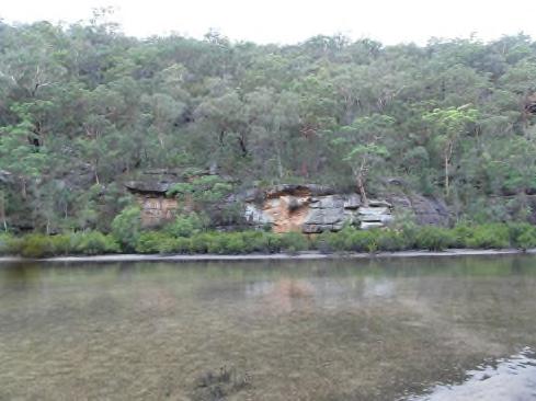
Figure 9.2-a: Example of a land feature that could indicate the likely presence of Aboriginal objects (E).
For further information on best practice guidelines, refer to:
Guide to Investigating, Assessing and Reporting on AboriginalCulturalHeritageinNSW(2011)
Due Diligence Code of Practice for the Protection of AboriginalObjectsinNSW(2010) by the Department of Planning and Environment, available at www.environment.nsw.gov.au
In NSW, historical archaeology refers to the archaeological (physical) record following British colonisation in 1788. Sites and places defined as historical archaeological items are classed differently from those listed as landscape or built heritage in that they usually comprise archaeological remains (deposits, artefacts, objects, or material evidence) principally present underground (often not visible on the ground surface). It is important to note there can be overlap between categories.
Known and potential archaeological relics in NSW are protected under the Heritage Act 1977 (NSW). Archaeological sites within Hornsby Shire are also protected under Clause 5.10 of the HLEP.
9.1 Introduction
9.2 Aboriginal Cultural Heritage
9.4 Heritage Items
9.5 Landscape Heritage
Desired Outcomes
a. Historical archaeological places (or potential archaeological sites) are appropriately identified, managed, conserved, and interpreted.
b. Development is based on an understanding of the site's heritage significance, including its archaeological significance and any remaining relics above or below the ground.
d. Mitigation measures should be appropriate to the level of heritage significance of the assessed site.
Notes:
To determine if a property is listed as an archaeological site, refer to Schedule 5 of the HLEP.
TheArchaeologicalAssessmentshouldbeobtainedearlyinthe development planning process to allow for any archaeological constraints or requirements to be factored into the project design.
Prescriptive Measures
a. An Archaeological Assessment should be supplied with a development application for any site identified as having archaeological potential.
b. The ArchaeologicalAssessment should be prepared in accordance with the guidelines of the Heritage Council of NSW by a suitably qualified heritage consultant.
c. In general, the principle of avoiding archaeological impacts should be applied to places of known archaeological significance.
Where a proposed development may impact a known or potential archaeological site, excavation permits may be required before works can proceed.
For further information on the historical archaeology of Hornsby Shire, refer to Council’s website: https://www.hornsby.nsw.gov.au/property/build/heritage/theheritage-of-hornsby-shire/historical-archaeology
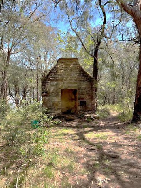
Figure 9.3-a: Example of a known archaeological site that would require an excavation permit prior to undertaking works (E).
This section provides objectives and controls for heritage places listed as individual or group heritage items within Schedule 5 of the HLEP 2013.
In general terms, new work to heritage items (excluding conservation work) should be located in areas that are not original or have been altered. The key objective is to retain elements that contribute to the significance of the item.
Alterations and additions are usually acceptable if they retain the significant form, scale, fabric, original details, and setting of the heritage item. Additions should not alter the scale of the original building when viewed from the public domain.
Note:
The controls for heritage items adopt a “whole of building” approach because heritage significance applies to the whole property, not just the front façade of a building or a particular element of a site.
Tolerance for change is a method used to guide change to avoid adverse impacts on heritage significance. It is based on an understanding of the significant attributes of a place, which may be embodied in its fabric, form, use or location, and how tolerant the attributes are to change without impacting the heritage significance.
Desired Outcomes
The major historical architectural and building types in Hornsby Shire are:
Colonial Georgian (1788 – 1850)
Victorian (1850 – 1900)
Federation & Arts and Crafts (1901 – 1925)
Inter-War (1925 – 1940)
Post-War (1940 – 1960)
Mid-Century (1950 – 1980)
Note:
For further information about common architectural styles, refer to the National Trust website: https://www.nationaltrust.org.au/wpcontent/uploads/2016/07/Australia-housing-Styles.pdf
a. Any change to a heritage item is based on an understanding of the significance of the item and ensures retention of the item’s heritage significant attributes.
b. Development that facilitates reasonable change to heritage items, particularly to meet contemporary amenity or safety standards, without unreasonably impacting heritage significance.
c. Alterations and additions that are sympathetic to significant attributes and complement the heritage item in terms of bulk, scale, form, setbacks, and materials.
Prescriptive Measures
a. Change to heritage items should retain the significance of the item and attributes that contribute to the significance, including form, fabric, use, and setting.
b. Change to heritage items should ensure that views oftheheritageitemanditssignificanceareretained.
Desired Outcomes
a. Heritage items are retained and conserved.
b. Significant fabric and features of heritage items are retained and conserved.
Prescriptive Measures
a. Heritage items should not be demolished. Costs associated with renovating or poor condition are not sufficient justification for demolition of an item.
b. Partial demolition of heritage items may be considered when the part of the building to be demolished is not original fabric or does not contribute to its significance.
c. Elements that contribute to the significance and setting of a heritage item should be retained. This includes original fabric, verandahs, balconies, interior elements, gardens, trees, and early outbuildings and where relevant.
Note:
The significance of a built heritage item is almost always embodied in its original fabric, its built form, walls, floors, roof, windows, doors, interior layout, spaces, garages, outbuildings, and features.
The original or historic use of a heritage-listed place is usually embodied in its significance. However, the use of heritage items may be changed when there is no viable option for its continued historic use.
Desired Outcomes
a. Heritage items are used for their original purpose unless no longer viable.
b. New uses are compatible with the heritage significance of the place.
c. New uses facilitate the ongoing viability of heritage items without adversely impacting heritage significance.
Prescriptive Measures
a. Historic uses of heritage items should be retained unless no longer viable.
b. New uses should be compatible with the heritage significance of the items.
c. New uses should facilitate the retention of the heritage significance of the building, including its original form, fabric, and setting.
d. Alterations to the original fabric to facilitate the new use should be minimised.
Desired Outcomes
a. Heritage items are retained on their original allotments where possible.
b. Subdivision maintains significant curtilages and settingofheritageitems,includingviewsandvistas, and enable the interpretation of original boundaries.
c. Subdivision supports the ongoing use and heritage significance of the heritage item.
Prescriptive Measures
a. Heritage items should be retained on their original allotment (or remaining curtilage) where possible.
e. The original and historic uses of the heritage item and its history should be interpreted through interpretive devices.
f. Original signs should be retained in their original place.
g. Impacts from the introduction of new services and BuildingCodeofAustralia(BCA) compliance should be minimised.
b. Adequate area around the heritage item should be retained to facilitate its ongoing use or allow for flexible adaptive reuse in a manner compatible with its history and heritage significance.
c. Subdivision should minimise impact on the visual setting of the heritage item. The lot containing the heritage item should have sufficient area to provide a visual setting that is proportional to the size and design of the building.
d. Changes affecting significant gardens should be avoided.
e. Impacts from associated development (such as driveways or hard stand areas) on the heritage significance and setting of the heritage item should be minimised.
f. Traditional relationships between the heritage item and street, such as presentation of the heritage item, should be retained.
g. Subdivisionlayoutshouldenablehistoricboundaries to be interpreted. This may be achieved by the location of internal subdivision lines along historic fence lines or similar.
Notes:
The original allotment of a heritage item is usually embodied in its significance. It provides the historic setting that contributes to an understanding and appreciation of the place.
Applications for subdivision of a heritage item will require a curtilage analysis with particular emphasis on the potential impact on garden and landscape settings.
Desired Outcome
a. Excavation on heritage-listed properties does not adversely impact the significance of the heritage item, including fabric and setting.
Prescriptive Measures
a. Excavation directly beneath heritage items is generally not supported.
b. If excavation directly beneath or within 1m of the heritage item is proposed, the application should be supported by a structural engineer’s statement confirmingtheheritageitemisabletowithstandthe works without loss of integrity.
c. Excavation should not alter the external scale and form of the heritage item.
d. Excavation for additions should be kept away from the original walls and foundations.
Desired Outcomes
a. Alterations and additions do not involve the removal of original fabric of a heritage item.
b. Alterations and additions are sited such that they do not alter the presentation of the heritage item from the public domain.
c. New works and changes are located away from areas that are intact or highly significant.
Prescriptive Measures
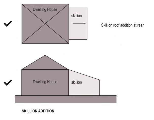
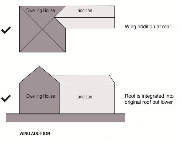
a. Additions should be located at the rear of a heritage item, away from the principal elevations and significant features of the heritage item.
Figure9.4-a:Sensitivelocatedalterationsandadditionssmaller in scale and located to the rear (E).
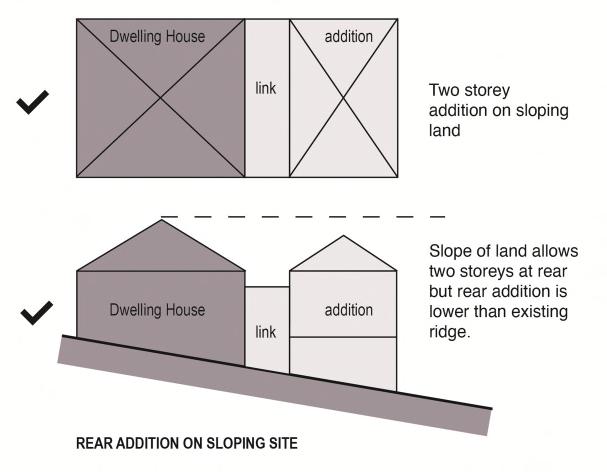
b. Additions should be smaller in scale and located behind and below the original roof ridge so that they do not alter the scale of the original building.
c. Where additions to the side of buildings are proposed, the addition should be set back as far as possible from the front building line.
d. Development on corner sites should address the corner and retain the original built form as it turns the corner. Additions should be located in the secondary street, at the rear of the original building.
e. Generous setbacks should be provided between new and old where appropriate.
9.4-b: Appropriate additions (I).
9.4-c: Inappropriate additions (I).
Desired Outcome
a. Works to heritage items retain and complement the significance of the item in terms of scale, form, and setbacks.
b. Alterations and additions complement the significance of the item in terms of the number of storeys.
Prescriptive Measures
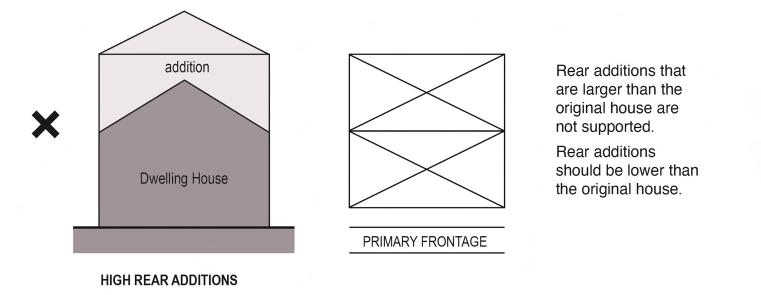
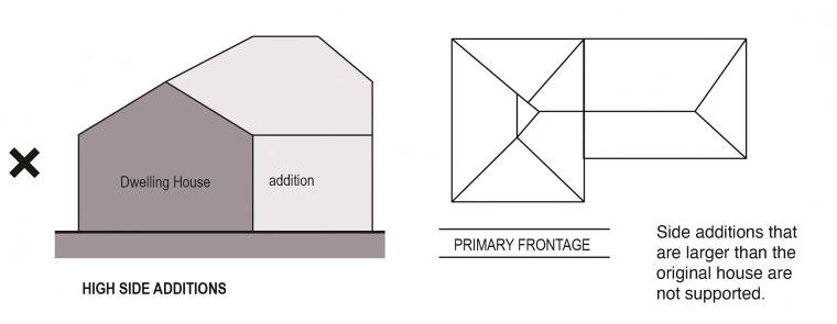
a. Alterationsandadditionsshouldnotaltertheoriginal scale or form of heritage items and should be smaller in scale and length than the existing building.
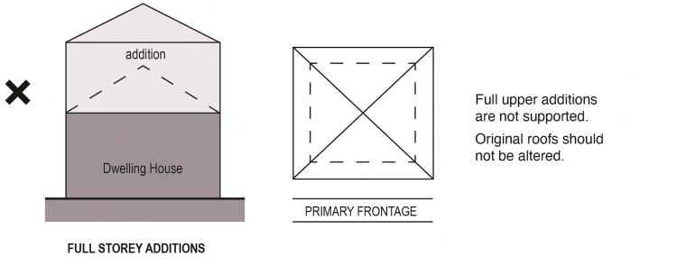
b. Large second-storey additions should be avoided. Upper-level additions should be included within the existing roof space as part of an attic-style addition.
c. Additional storeys directly above heritage items are generally not supported. The original scale and roof form of heritage-listed buildings should be retained.
d. Additions to single-storey heritage items should be single-storey and located at the rear of the existing building.
e. New roofs and building mass should not project above the height of the original building or change the building’s scale.
f. Extensions, alterations, and additions should not visually dominate or compete with the original scale of the existing buildings to which they are added.
Desired Outcomes
a. Significant internal fabric and features of heritage items are conserved.
b. Change to the original layout of heritage items is minimal.
d. Services may be upgraded but should not impact significant interior fabric.
e. Original materials, finishes, and details should be retained, and their repair using traditional techniques is encouraged.
f. The reinstatement of missing elements and details, where known, and the removal of past unsympathetic changes, is encouraged.
Desired Outcomes
Prescriptive Measures
a. Development should retain significant interior elements (for example, wall nibs, decorative ceilings, picture rails, architraves, feature tiling or features such as fireplaces).
b. Significant and original internal layouts should be retained, particularly reception rooms and entry halls. New work should be located away from intact original spaces and features.
c. Kitchens and bathrooms can generally be updated, but structural changes should be avoided.
a. Exterior details and finishes of heritage-listed buildings are conserved and maintained.
b. Missing external features are appropriately reinstated.
Prescriptive Measures
a. Original architectural detailing and features, such as barge boards, finials, trims, decorative fretwork, window awnings, chimneys, and verandahs, should be retained and conserved.
b. New detailing to the original building should complement the character of the heritage item in terms of style, material, and detail.
c. New windows inserted into the existing fabric of a heritage building should be ofa size, proportion, and type compatible with the building’s architectural style/period.
d. Existing incompatible/intrusive elements (e.g., nonoriginal aluminium windows and doors, aluminium or vinyl cladding) in street elevations and prominent locations should be replaced with traditional materials when alterations and additions are proposed.
e. Significant building facades (such as shop fronts) should be retained and conserved.
9.4.10
Desired Outcome
a. Alterations and additions to heritage items retain and complement the significance of the item in terms of architectural style.
Prescriptive Measures
a. Additions should have a design and materiality that complements the architectural style/period of the heritage item.
b. Additions may have a contemporary architectural style that distinguishes them from the original building, provided they are located at the rear, not visiblefromthepublicdomain,andtheform,details, and materiality do not detract from the heritage item.
c. Decorative features and elements should only be added to buildings if there is historical evidence for features on the building.
d. Extensive blank or unarticulated walls are discouraged. Articulation should be achieved through the use of a variety of materials or design elements such as soldier/string courses, windows, timber inserts, colours or the like.
Desired Outcome
a. Works to heritage items retain and complement the significance of the item in terms of external colours, materials, and finishes.
Prescriptive Measures
a. Original wall cladding should be retained and conserved, including face brickwork.
b. Paintwork should not be applied to original face brickwork, stonework, exposed bricks on chimneys, terracotta chimneypots, tessellated or glazed tiling, slate verandah edging and steps, or any other unpainted surfaces.
c. Face brickwork that is already painted or rendered should be restored, where possible, to its original un-painted state.
d. For brickwork that was originally rendered, cement render should be complementary to, and consistent with, the architectural style of the item.
match the heritage item but should be compatible with the original materials, textures, and details of the item.
Notes:
Single-colour solutions are generally not appropriate for heritage items. Two or more paint colours should be used to highlight windows and other features in keeping with the architectural style and period of the building.
Dark colours, such as black and grey, should not be used on heritage items unless supported by historical evidence.
Desired
e. Modifications to face brick dwellings should use the original style of bricks, window heads, mortar joints, and other building details.
f. For weatherboard buildings, new weatherboards should have a traditional width and profile to match the original weatherboards.
g. When proposing to repaint the external fabric of a heritage item, reinstatement of traditional colour schemes is encouraged. Evidence of original schemes may be determined by scraping back paint from areas that are not subject to intense weathering.
h. The materials, textures, and colours of alterations and additions to a heritage item need not exactly
a. Original roofs, including roof forms, detailing, materials, and significant features, are conserved.
Prescriptive Measures
a. Changes to the form of original roofs of heritage items are generally not supported. Original and traditional roof forms and materials should be retained.
b. Roof additions should generally be located at the rear of an existing building and should be lower than the main roof.
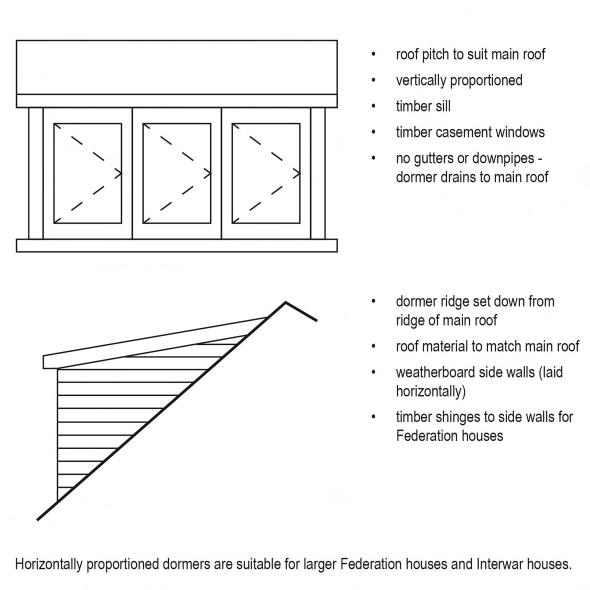
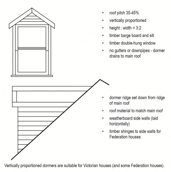
c. Dormers in the frontroof plane ofheritage items are generally notsupported. Dormers should be located at the side or rear and should be of traditional vertical proportions with either gable or hipped roof forms. Where not visible from the street, a wider dormer form may be considered.
d. Dormer windows should be positioned below the main roof ridge.
e. The original roofing material of a heritage item should only be replaced where justified due to deterioration, and only if new roofing matches original materials.
f. Roof elements such as skylights should not be located in original roofs where visible from the public domain.
9.4-d: Appropriate dormer location and scale (I).
Desired Outcome
a. The integrity of original verandahs and balconies, including their open form, detailing, materials, and significant features, is maintained.
Prescriptive Measures
a. Verandahs and balconies on the front and sides of a heritage item should not be infilled.
b. Existing verandah or balcony infills should be removed when alterations and additions are proposed.
c. Original decorative detailing of front verandahs should be retained and conserved or reinstated if missing.
Desired Outcomes
a. Significant garages that contribute to the significance of heritage items are conserved.
b. Garages and carports are designed as secondary structures and do not dominate or impact the significant form or setting of heritage items.
c. Garages and carports complement the significance of heritage items in terms of form, materials, and details.
d. New driveways are minimised and do not impact the setting of heritage items.
Prescriptive Measures
a. Where it is physically possible, new car parking should be consistent with the historic placement of parking structures on the site.
b. Where original and early garages, coach houses, and stables survive, they should be retained and conserved.
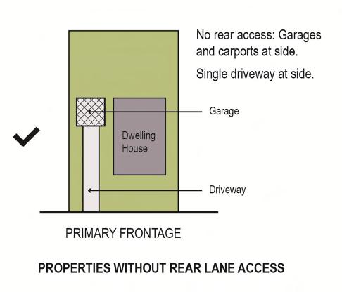
f. Garages and carports located adjacent to the primary building may be considered if they are set back behind the front building alignment as far as possible.
g. Suitably landscaped uncovered car parking hardstand areas forward of the building alignment may be considered if they retain and complement the garden setting.
h. Free-standing garages and carports should have pitched roofs, or a skillion roof when the garage or carport attached to the side of a dwelling.
i. Carports should be designed as open structures.
c. New parking areas, garages, and driveways should be designed so they do not dominate the principal elevations or detract from the curtilage or setting of the heritage item.
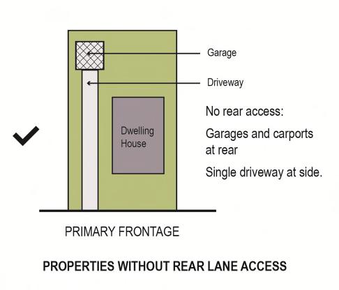
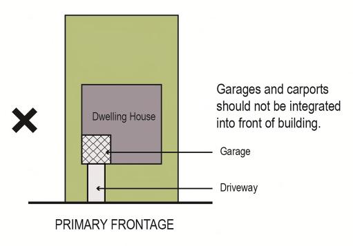
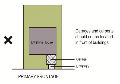
d. Garages and carports should not be constructed forward of the building alignment of a built heritage item. Garages and carports should be located at the rear of the property and separately articulated from the dwelling.
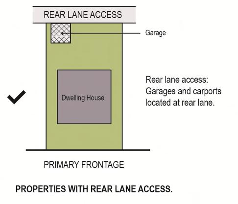
e. Where a property has access to a rear lane, vehicle accommodation should be located adjacent to the laneway with vehicle access from the lane.
j. Multiple driveways and double width vehicle entries should be avoided and extent of paved area to the street should be minimised unless it is consistent with the historic character of the property.
k. Finishes to new or refurbished driveways should matchoriginaldrivewayfinishesorbeappropriate to the architectural style of the heritage item.
l. Where original concrete wheel strips exist, they should be retained with grass in between.
m. Changes to driveway entries should be avoided where street trees, significant garden layouts, mature plantings, or rock outcrops would be affected.
n. Original garage doors should be retained and conserved, where possible. Where replacement doors are proposed for original or early garage structures, they should be similar in colour, materials, and detail to the original.
o. New carport and structures should reflect the existing and original materials and features of dwellings, such as windows, doors, and string coursing.
p. Lofts and attics above garages are not supported unless it can be demonstrated that it will not impact the heritage significance of the item, including views and setting.
Desired Outcomes
a. Original and significant fences and gates are maintained.
b. New fencing to heritage items complements the heritage significance and architectural style of the item.
Prescriptive Measures
a. Original fences should be retained and conserved, where possible.
b. Modifications to the front fence of heritage items should be designed and constructed to reflect the materials, historic style, and heritage significance of the item.
c. Where fences have been changed, they should be reconstructed based on their original design. If the original design is not able to be identified, the fence should be built to the architectural style of the building.
d. New fences should be avoided where fences were not originally constructed.
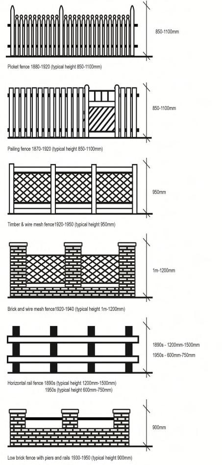
e. Traditional materials for new orexisting frontfences may include timber, iron, brick, and stone. Nontraditional fencing materials such as Colorbond and plastic should be avoided.
f. The location of gates should be retained where they form part of a traditional garden layout.
g. High solid fences and gates should be avoided unless on a major road with significant traffic volumes. In these instances:
fences should be a maximum height of 1.8m
piers should be a maximum height of 2m,
fences should incorporate appropriate articulation.
h. For corner sites, the style and height of the front fence should continuearound both street frontages.
Notes:
Council may require the fence to be set back 600mm from the front property boundary to allow hedge planting to soften the appearance in the streetscape.
Roads with significant traffic volumes include Pacific Highway (south of Edgeworth David Avenue); Pennant Hills Road; BeecroftRoad; Castle Hill Road;Boundary Road;and NewLine Road.
Historical photographs can assist with identifying original fences. The Hornsby Shire Local Studies Library resources are a valuable source of historical records.
This section applies to the management of gardens, trees and landscapes associated with a heritage listed building. When a property contains a garden, tree or otherlandscapeelementthatis heritagelisted inits own right, the controls in this section and Section 9.5 both apply.
Desired Outcomes
a. The garden and landscape setting of heritage items and significant historic garden layouts and plantings are conserved.
b. New gardens complement the significance of heritage items.
Prescriptive Measures
a. Garden elements that are original to the building or contribute to its significance and setting, including trees, structures, rock outcrops, plantings, and garden layouts, should be retained.
b. New garden elements, including plant species, should be designed based on an understanding of the significance of the heritage item and to complement the period and style of the item.
c. Additions and carparking structures should be located to avoid impact on significant trees and gardens.
d. Mature trees should not be removed unless diseased or dangerous.
e. Mature trees that are approved for removal should be replaced with a tree in the same or similar location that will mature to a similar height and canopy.
Notes:
Examples of historic garden elements and structures can include, but are not limited to, tennis courts, croquet lawns, grottos, ferneries, garden terracing, lawn edgings, etc.
Desired Outcome
a. Swimming pools, fencing, and equipment do not impact the heritage significance of the item, including fabric, setting, and views.
Prescriptive Measures
a. Swimming pools shouldbe located atthe rearofthe property, where they will not impact the setting of the heritage item when viewed from the public domain.
b. Swimming pools should not require the removal of landscape elements that contribute to the significance and setting of a heritage item.
Theuseoftraditionallandscapingmaterialssuchassandstone, brick, and gravel are encouraged.
c. Pool fences and equipment should be located to ensure they do not impact significant fabric and settings of heritage items.
Roofscapes of heritage items are highly significant to their character, including their form, fabric, setting, and views. Installation of service elements should be sensitivelylocated and designed to avoid impacts on the item.
Desired Outcome
a. Skylights, solar panels, and services on sites with heritage items do not impact the heritage significance of the item, including form, fabric, setting, and views.
Prescriptive Measures
a. Elements such as solar panels, hot water heaters, ventilators, antennae, skylights, solar tubes, air conditioning units and the like should be placed where they do not impact original fabric and located to minimise visibility from the street.
b. Solar panels and hot water heaters may be considered where visible from the primary street, if visibility has been minimised and justification has been provided that there is no suitable alternative location.
c. If visible from the street, services should match the roof colour and be laid flush with the roof.
Desired Outcomes
a. The integrity of outbuildings of heritage items is retained and conserved.
b. New outbuildings on sites with heritage items do not impact the significance of the item, including fabric, setting, and views.
Prescriptive Measures
a. Original and early outbuildings and garden structures of heritage items should be retained and conserved.
b. New garden structures or outbuildings, including gazebos, sheds, stores, and cabanas, should be located at the rear of the heritage item where not visible from the street.
c. The scale of any outbuilding or structure should be subservient to the main house; colours and materials should match the house.
9.4.20
Interpretation should be incorporated into any major redevelopment of a heritage item. This applies particularlytoplacesthatareaccessibletothepublicand where a heritage item is to be integrated into a new development.
Note:
The Heritage Interpretation Plan should be prepared by a suitably qualified and experienced heritage interpretation specialist. Implementation of the heritage interpretation devices will be imposed by Council as a condition of consent.
HeritageInterpretationPlansshouldbepreparedinaccordance with ‘Interpreting Heritage Places and Items’ guidelines published by Heritage NSW. Refer to: https://www.environment.nsw.gov.au/research-andpublications/publications-search/interpreting-heritage-placesand-items-guidelines
Desired Outcome
Desired Outcome
a. The heritage significance and original fabric of heritage items are retained when works are proposed for compliance with current building, safety, and access standards.
Prescriptive Measures
a. Proposed fire, access, and BCA upgrades should be accompanied by a heritage impact statement explaining the impact of the works on the original fabric.
a. Heritage significance of items is interpreted within new development that involves publicly accessible spaces or where a heritage item is to be integrated into a new development.
Prescriptive Measures
a. Development Applications for publicly accessible heritage items or where a heritage item is to be integrated into a new development should be accompanied by a Heritage Interpretation Plan.
b. Heritage interpretation is to be provided where large-scale works are proposed to a heritage item.
b. Fire, access, and safety upgrades are to retain the significance of the heritage item.
c. Impact to the original fabric should be avoided where possible, and the original fabric should be protected.
d. Alternative solutions to achieve compliance should be considered to avoid impact on the original fabric.
Note:
Heritage items may not always comply with current building and access standards and safety codes. When significant upgrade work is needed, development consent is required.
Desired Outcome
a. Secondarydwellingsonsiteswithheritageitemsdo not impact the heritage significance of the item, including fabric, setting, and views.
Prescriptive Measures
a. Secondary dwellings should not impact the heritage significance of the item, including fabric, setting, and views.
b. Secondary dwellings should not be attached to heritage listed buildings. Detached secondary dwellings should maximise the setback between the two dwellings.
c. Secondary dwellings should be located at the rear and not visible from the public domain.
d. Secondarydwellingsshouldbedesignedwithabulk and scale that is subservient to the original building, and with a form, materials, and details that complement the original building.
e. Additional driveways to secondary dwellings should be avoided.
Desired Outcomes
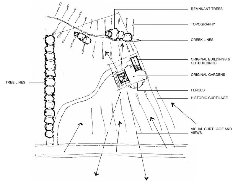
a. Development protects the physical and visual setting of rural heritage items.
b. New dwellings, alterations or additions to rural heritage sites support modern living arrangements whilst retaining the significance of heritage-listed buildings.
Prescriptive Measures
a. New development should be located to minimise adverse impacts on the historic and visual curtilage of the heritage item.
b. The setting of the heritage item should be maintained through the design, siting, and landscaping of new elements.
c. Alterations and additions to small heritage-listed cottages should be in the form of pavilion-type extensions.
d. The design of a development that is on or adjoins, a rural heritage item should respect:
the historic subdivision pattern associated with the item.
topographic features such as tree lines, fences or creeks that form natural lines of division.
stands of vegetation (natural bush or regenerated areas) that could be impacted by development.
view corridors to or from the heritage item.
building scale adjoining the item.
e. Building materials, new fencing, and new landscaping should be consistent with the significance and character of the heritage item.
f. Screening measures that may be needed if the new development is much larger in scale than the heritage item.
g. Developmentthatinvolvesanewdwellingonarural heritage site should provide for conservation works to the heritage item and its setting. A Conservation Management Plan or Heritage Asset Action Plan may be required depending on the scale of the site and scope of works.
The following additional controls apply to heritage-listed commercial buildings.
Desired Outcomes
a. Development retains the significance of heritagelisted commercial buildings, including original shopfronts.
b. New development complements the heritage significance and architectural character of heritagelisted commercial buildings.
c. Signage is consistent with the significance of the heritage item and minimises and complements, rather than dominates, the architectural characteristics of the building.
Prescriptive Measures
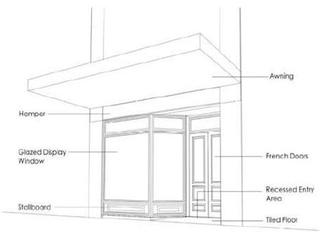
a. Original elements and features, including features above awning level, should be retained.
b. Replacement shopfronts, where original shopfronts have been altered, should be based on historic information and/or interpretation of period details.
c. New work should respect the form, scale, and detailing of the existing building and streetscape features, including the parapet line.
d. Infilling of original verandahs should be avoided.
e. Colour schemes for repainting should be based on historical evidence or period colour charts.
f. Signs should be located on parts of the building that have traditionally been used for signs or advertising. Above awning signs should be avoided except where part of the original design. Projecting signs above awnings should be avoided. Signs should be located in the following preferred locations:
under awning
awning fascia
i. The lettering of signs on heritage items should complement the architectural style of the building. Suitable lettering styles may involve shaded letters, the mixing of sizes and styles of letters, and ornamental scrolls relevant to the period of the building.
j. Where works are proposed to heritage items, Council encourages and may require a detailed fabric survey for significant heritage items to identify original significant fabric and internal elements that should be retained and conserved.
Notes:
a transom sign above the door or shopfront (top hamper)
inside the display window
below the window sill
flush wall signs
g. Signs on shop windows should not exceed 25% of the total area of the shop front glazing.
h. Colours of signs should be based on historical research and appropriate for the heritage item. Generally, neutral, ormutedcolours areappropriate, e.g., maroon, dark green, terracotta, brown, charcoal, etc, highlighted with creams, ochres, pinks, and earth tones.
Hornsby Shire's commercial heritage items are predominantly from the Federation period and include a grouping along Peats Ferry Road in the west precinct of the town centre. Other heritage-listed commercial buildings are at Waitara, Beecroft, and Brooklyn.
While some shopfronts have been altered, most of Hornsby Shire’s commercial heritage retains period detailing above awning level. Important considerations for future proposals are sympathetic signs, colour schemes, and façade treatments.
This section provides desired outcomes and prescriptive measures for cultural and natural landscape heritage items listed under Schedule 5 of the HLEP 2013. It also includes controls for significant gardens and landscapes associated with built heritage items and a clear crossreference to any controls that apply across both sections.
Landscape heritage in Hornsby Shire includes the following types of landscapes:
designed landscapes – cultural gardens, bushland gardens, landscape structures, parklands, cultural street trees, and memorials.
organically evolved landscapes – bushland, natural street trees, individual or groups of trees
associativelandscapes–memorials,school,church, and institutional grounds, viewscapes, scenic landscapes, and windbreaks
natural landscapes – bushland, geological formations, natural features, and natural sites
The cultural values of landscapes, as with all types of heritage items, can relate to their aesthetic, archaeological, historical, scientific, social, or architectural values, any or all of which may co-exist in the one place.
Whenapropertyislistedbothforthebuildingonthe site and its garden, tree or landscape element, this section, and the controls in Section 9.4.16 apply.
Note:
For definitions of the types of landscapes, refer to: https://www.hornsby.nsw.gov.au/property/build/heritage/theheritage-of-hornsby-shire/landscape-heritage
Tolerance for change is a method used to guide change to avoid adverse impacts on heritage significance. It is based on an understanding of the significant attributes of a place, which may be embodied in its fabric, form, use or location, and how tolerant the attributes are to change without impacting the heritage significance.
Desired Outcome
Cross References to Other Sections
9.4.2 Demolition
9.4.4 Subdivision
9.4.6 Siting
9.4.14 Carparking and Driveways
9.4.15 Fencing and Gates
9.4.16 Gardens, Trees and Landscaping
9.4.23 Secondary Dwellings
a. Any change to a heritage landscape is based on an understanding of the significance of the landscape and ensures the retention of its heritage-significant attributes, such as form, fabric, use, and setting.
b. Change to heritage landscapes is limited to areas thathave already been changed ordo not contribute to the significance of the landscape.
Prescriptive Measures
c. Change to landscape heritage items should retain the significance of the item and all attributes that contribute to the significance, including form, fabric, use, and setting.
d. Change to landscape heritage items should be basedonanunderstandingofthesignificanceofthe heritage item and its significant attributes.
Desired Outcomes
a. Retention of original and significant cultural and natural landscapes and landscape features within new development, including views and vistas.
b. Retention of landscape features and elements that contribute to the significanceand setting ofheritage items and heritage conservation areas.
c. New development complements and enhances significant landscapes and landscape features, including those that contribute to the setting of heritage items and heritage conservation areas.
d. Subdivision retains significant landscapes and landscape elements within their original curtilage and setting.
Prescriptive Measures
a. Significant landscapes and the elements that contribute to them should be retained and conserved.
b. New planting in significant gardens should involve plant species based on original plantings.
c. Trees and plant species that have reached the end oftheirlifeorneedtoberemovedforsafetyreasons should be replaced by the same species.
d. Changes to heritage landscapes should be based on an understanding of the heritage significance of the landscape and the contribution of the individual elements.
e. Driveways to heritage landscapes should utilise existing access points where possible. New driveways should be avoided, and new access points should be minimised and single width only.
f. Change should be limited to areas where change has already occurred or where there is little or no significance.
Desired Outcomes
a. Subdivision retains significant landscapes and their setting within one allotment.
b. Subdivision avoids impacts on natural landscapes and landscape elements and their setting.
c. Subdivision retains views of significant landscapes from the public domain.
Prescriptive Measures
a. Subdivision of a property that is listed as a landscape heritage item should ensure that the heritage significance of the landscape is retained, including all significant landscape elements and setting.
Desired Outcomes
a. Original and significant fences and gates are maintained.
b. New fencing to heritage items complements the heritage significance and architectural style of the item.
Prescriptive Measures
a. Original fences should be retained and conserved, where possible.
b. Subdivision of a property that is listed as a landscape heritage item should ensure that all landscape elements that contribute to the significance of the item are retained on one lot to protect the significance of the item and preventloss of significance to rear garden elements, including tree canopies.
b. Where fences have been changed, they should be reconstructed based on their original design. If the original design is not able to be identified, the fence should be built to the style of the associated landscape.
c. New fences should be avoided where fences were not originally constructed.
d. Traditional materials for new orexisting frontfences may include timber, iron, brick, and stone. Nontraditional fencing materials such as Colorbond and plastic should be avoided.
e. The location of gates should be retained where they form part of a traditional garden layout.
Desired Outcome
a. Secondary dwellings on sites with landscape heritage items do not impact the heritage significance ofthe itemand the landscape elements that contribute to the significance.
Prescriptive Measures
a. Secondary dwellings should not impact the heritage significance of the landscape, including setting and views.
b. Secondary dwellings should be located at the rear and not visible in public domain views.
This section provides desired outcomes and prescriptive measures for places located within heritage conservation areas as listed within Schedule 5 of the HLEP2013.Thesecontrolsrelatetodevelopmentwithin heritage conservation areas. Council encourages new development ofa high design standard thatrespects the significance of the area.
This section provides general controls that apply to all Heritage Conservation Areas in Hornsby Shire, with detailed additional controls where appropriate for specific Heritage Conservation Areas (within the Character Statements) provided in Sections 9.7–9.12.
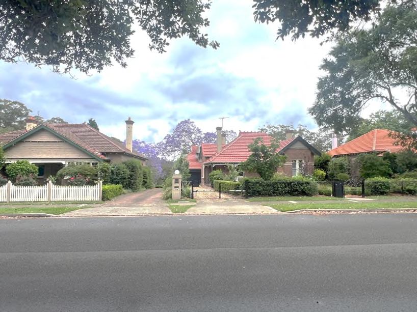
The particular characteristics that make each Heritage Conservation Area significant are described in the Character Statements in Sections 9.7–9.12. For most areas, this includes the history of subdivision, main building periods and associated architectural styles, and consistency of buildings in terms of form, height, setbacks, materials, landscape, trees, and streetscape elements.
Developmentin Heritage Conservation Areas is required to respect the significant characteristics of the area. The controls place emphasis on how changes appear from public spaces, and ‘fit in’ in relation to the predominant built form, style, and landscape character of the area. Cross
What is a Heritage Conservation Area?
Heritage conservation areas have the ability to demonstrate the course and pattern of historical development in alocal area.Heritage conservationareas may be specific areas such as suburbs, particular subdivision patterns, streetscapes, built heritage, or designed areas and precincts that are recognised by a community for their distinctive historic character. They often provide evidence of a particular historical period of development and/or a distinct architectural style and generally have a high proportion of original buildings.
Heritage conservation areas are protected because they exemplify a cohesive sense of place and character that is valued by the community for historic, aesthetic, social and/or scientific values. The characteristics of an area may be rare or representative. Often, an area’s significance is associated with the underlying land subdivision layout and street pattern. The subdivision arrangement establishes and expresses specific relationships between topography, landforms, landscape features, vegetation, streets, individual building allotments, and built form. In many instances in heritage conservation areas, there is a consistent and harmonious visual arrangement in the use of materials, built form, and scale, evidenced by the particular period of historic development.
Buildings within the Hornsby Shire Heritage Conservation Areas contain characteristic elements and non-characteristic elements.
Characteristic elements reflect the key heritage values of the heritage conservation area but do not meet the threshold for individual heritage listing. Characteristic elements within a heritage conservation area can include buildings, landscape features, trees, fences, curbs and gutters, natural landforms, and other built features.
Non-characteristic elements do not display the key heritage values that reflect the significance of a heritage conservation area to varying degrees.
Tolerance for change is a method used to guide change to avoid adverse impacts on the heritage significance of anarea.Itisbasedonanunderstandingofthesignificant attributes of an area, which may be embodied in its fabric, form, use or setting, and how tolerant the attributes are to change without impacting the heritage significance.
Desired Outcome
d. Change within a heritage conservation area is based on an understanding of the area's significance and retains its heritage significant attributes, including form, fabric, use, and setting.
e. Development that meets contemporary amenity or safety standards without unreasonably impacting heritage significance.
f. Developmentthat is sympathetic to the streetscape character of the heritage conservation area in terms of bulk, scale, form, setbacks, style, and materials.
Prescriptive Measures
a. Change to heritage conservation areas should retain the attributes that contribute to the significance of the item, including form, fabric, use, and setting. This is usually those elements that can be seen from the public domain, such as scale, form, setbacks, architectural character, landscape setting, and original features.
b. Development within heritage conservation areas should be based on an understanding of the significance of the area and its significant attributes.
Buildings that contribute to the significance and character of a heritage conservation area should be retained.
Desired Outcomes
justification for the demolition of characteristic buildings.
b. Demolition of characteristic buildings that are not intact should be avoided, characteristic detailing should be reinstated, and changes reversed.
c. Non-characteristic buildings and later additions to characteristic buildings may be demolished and replaced with buildings or elements that complement the character and significance of the heritage conservation area.
a. Characteristic buildings are not demolished to maintain the integrity, character, and significance of the heritage conservation area.
b. Original houses from Victorian, Federation, InterWar, and Post-War periods within heritage conservation areas are retained and conserved.
c. Uncharacteristic buildings are replaced by buildings that make a positive contribution to the heritage conservation area.
Prescriptive Measures
a. Characteristic buildings should be retained. Poor condition and lack of maintenance are not
Subdivision patterns are often significant to heritage conservation areas. The design and layout of land subdivisions evidence specific responses to the underlying landform, topography, trends in planning,and suburban living. Each of these characteristics, to varying degrees, contributes to the overall coherence of the historic urban area, including the arrangements and relationships between the streetscape, building allotments, and built form and scale.
a. Minimise allotment subdivision to retain the pattern andarrangementof theoriginalspatiallayoutoflots.
Prescriptive Measures
a. Lot boundary changes are generally not supported where the development pattern or early subdivision isintegraltotheheritagesignificanceoftheheritage conservation area.
b. Subdivision should conserve the important characteristics of the subdivision pattern, allotment layout and width, streetscape character, natural landform, bush setting, landscape features, and other notable features of the significant period of development.
c. Subdivision should allow for the ongoing interpretation of the original subdivision through the siting of built form and landscape design.
d. A single driveway is preferred for joint right-of-way access to battle-axe allotments.
Each heritage conservation area has important views and vistas that form part of its significance, historic character, and aesthetic qualities. The public enjoyment of views to, and from, important landmarks, historic buildings, or along important historic streets should be
considered when proposing development within a heritage conservation area. Refer to the Character Statement for each Heritage Conservation Area for the list of important views and vistas (Sections 9.7–9.12).
Desired Outcome
a. Public domain views, including views and vistas along historic streetscapes and to and from characteristic heritage elements, should be retained.
Prescriptive Measures
a. Development should maintain public views or vistas, including views along historic streetscapes and views to and from characteristic heritage elements.
b. New development should include appropriate setbacks, siting, and scale to ensure that important views and vistas are retained.
Desired Outcome
a. Development within heritage conservation areas retain and complementthe characterof the heritage conservation area in terms of scale, form, architectural style, detailing, and materials.
b. The characteristic scale, form, and character of streetscapes in heritage conservation areas is retained.
Prescriptive Measures
a. New development should retain the significance and streetscape character of the heritage conservation area, as defined in the Character Statement for each HCA or precinct (Sections 9.7–9.12).
b. New development should preserve significant aspects of the heritage conservation area, such as scale, roofscape, building form, setbacks, external materials, details, bulk, window placement and openings, verandahs, and landscape elements.
e. Ancillary structures such as swimming pools, tennis courts, and sheds should be located in rear yards where they are not visible from the street.
Figure 9.6-a: Take clues from traditional fences in the heritage conservation area (E).
Desired Outcome
a. Development within heritage conservation areas retain and complementthe characterof the heritage conservation area in terms of scale, form, architectural style, detailing, and materials.
Prescriptive Measures
a. Where proposed new development will be visible from the street, it should respectfully respond to and complement the architectural style of characteristic development within the heritage conservation area, as defined in the relevant Character Statement (Sections 9.7–9.12) and demonstrated on characteristic buildings.
b. Contemporary-styled development that is not consistent with the historic character of the area shouldonlybeusedinareasthatarenotvisiblefrom the street.
c. Originaldecorativefeaturesandelementsshouldbe replaced where missing.
c. New development should be designed and located to have minimal visibility from the street, such as behind the front building line.
d. Ensurefrontgardensare partofthestreetscapeand appropriate to the character of the heritage conservation area. Use traditionally designed gardens that enhance the appearance of historic houses and the streetscape.
d. Significant changes to front elevations should be avoided where the existing building retains detailing characteristic of the heritage conservation area.
Desired Outcome
a. Development is sited such that they are not visible from the street.
Prescriptive Measures
a. New development should be located so they have minimal visibility from the street.
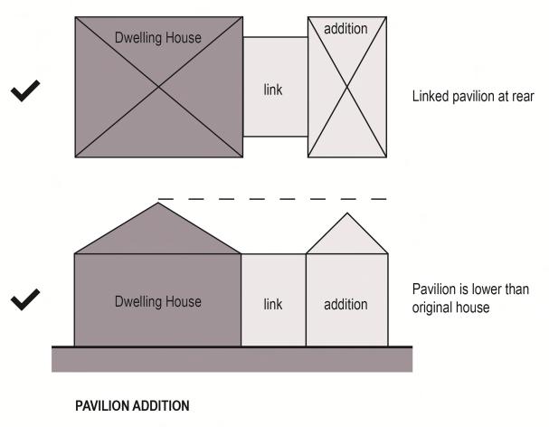
b. New development should be located at the rear of dwellings. Pavilion additions are encouraged. A contemporary or contrasting form may be used where such additions are notvisible from the street.
c. Where development to the side of buildings (attached or detached) is proposed, it should be set back as far as possible from the existing front building line.
d. Development on corner sites should address the corner and retain the original built form as it turns the corner. Additions should be located in the secondary street, at the rear of the original building.
e. New development should be submissive in scale to the original building and clearly identifiable as new work whilst using a design and materiality that complements the character of the host building and the heritage conservation area.
f. Separation should be provided between new and old work by using a glazed section to link the new addition to the existing building and/or using shadow lines and gaps to articulate the distinction between old and new.
Desired Outcome
a. Development within heritage conservation areas retains and complements the character of the heritage conservation area in terms of scale and form.
d. Upper-level additions may be included within the existing roof space as part of an attic-style addition. Dormersandskylightsshouldbelocatedontheside or rear roof plane.
Note:
Refer to diagrams for appropriate additions (Figure 9.4-b) and inappropriate additions (Figure 9.4-c) in Section 9.4.
Desired Outcome
Prescriptive Measures
a. New development should not alter the original scale or form of characteristic buildings.
b. New development to non-characteristic buildings should be consistent with the scale and form of nearby characteristic buildings.
c. Where possible, additional floor space should be located at the rear to retain the original scale and form of the building.
a. The integrity of buildings that reflect the character of the heritage conservation area are conserved, including original roof forms, detailing, materials, and significant features.
Prescriptive Measures
a. Original and traditional roof forms and materials should be retained. Alterations to original roofs should complement the style, form, and pitch of the original roof or be consistent with characteristic buildings.
b. Roof additions should generally be confined to the rear of an existing building and should be lower than the main existing roof.
c. Dormers to the side of existing roofs should be of traditional vertical proportions with either gable or hipped roof forms. Where not visible from the street, a wider dormer form may be considered.
d. Where dormers are visible from the street, they should be positioned below the main roof ridge and designedwiththeproportion,size,anddetailsofthe style of the host building.
e. Balcony dormers should not be visible from the street.
f. Original chimneys should be retained unless they are proven to be structurally unsound, in which case they should be reconstructed in the original detail and design.
g. New roofing should be consistent with existing materials.
h. The re-roofing of the main body of the house should use materials that match the original materials.
Note:
Refer to diagrams for appropriate dormer windows (Figure 9.4d) in Section 9.4.
Desired Outcome
a. The integrity of buildings that reflect the character of the heritage conservation area is maintained, including original roof forms, detailing, materials, and significant features.
Prescriptive Measures
a. Original architectural detailing and features to street elevations, such as barge boards, finials, trims, decorative fretwork, window awnings, and front verandahs, should be retained and conserved.
b. New detailing should be complementary to the character of characteristic buildings within the heritage conservation area in terms of style, material, and detail.
c. Where new doors, windows, and verandahs are visible from the street or prominent location, they should be of similar proportion, size, location, and detailing to the original elements. Original door and window openings should be retained and repaired. If original doors or windows have been lost, they should be replaced with one of similar size, type, and material for the age and style of the building.
d. New windows to be inserted into the existing fabric of a heritage building should be of a size, proportion, and type that is compatible with the building’s architectural style/period.
e. Existing incompatible/intrusive elements (e.g., nonoriginal aluminium windows and doors, aluminium or vinyl cladding) in street elevations and prominent locations should be replaced with traditional materials when alterations and additions are proposed.
b. Paintwork should not be applied to any original brickwork, stonework, exposed bricks on chimneys, terracotta chimneypots, tessellated or glazed tiling, slate verandah edging and steps, or any other unpainted surfaces.
c. Face brickwork that is already painted or rendered should be restored, where possible, to its original un-painted state.
d. For brickwork that was originally rendered, use cement render that is complementary to and consistent with the architectural style and colour schemes.Forbrickworkorrenderthatwasoriginally painted, repainting should be undertaken in the same manner as the original colour of the building.
Desired Outcomes
a. The integrity of buildings that reflect the character of the heritage conservation area is maintained, including original roof forms, detailing, materials, and significant features.
Prescriptive Measures
a. Original wall cladding should be retained and conserved, including face brickwork. Modifications to face brick dwellings should use the original style of bricks, window heads, mortar joints, and other building details.
e. For weatherboard buildings, new weatherboards should have a traditional width and profile to match the original weatherboards.
f. New materials should reflect the historic character of the heritage conservation area, where visible from the street.
g. For new development, new materials may include steel windows, render, painted finishes, and tiled roofing where they do not impact the streetscape character.
h. External colour schemes should be in keeping with the original character of the heritage building, where possible, based on physical or documentary evidence in keeping with the architectural style and period of the building.
i. Two or more paint colours should be used to highlight windows and other features in keeping with the architectural style and period of the building.
j. Dark colours, such as black and grey, are generally not suitable in heritage conservation areas unless there is historic evidence of their use.
Desired Outcome
a. The integrity of buildings that reflect the character of the heritage conservation area is maintained, including original verandah and balcony roof forms, detailing, materials, and significant features.
Prescriptive Measures
a. Verandahs and balconies on the front and sides of characteristic or non-characteristic buildings should not be infilled.
b. Existing verandah or balcony infills should be removed when alterations and additions are proposed.
c. Original decorative detailing of front verandahs shouldberetainedorreinstatedifmissing,basedon documentary evidence.
Desired Outcome
a. Garages and carports are designed as secondary structures and do not dominate or impact the significant streetscape of heritage conservation areas.
b. Driveways are minimised and do not impact the significant character of heritage conservation areas.
Prescriptive Measures
a. Garages and carports should not be constructed forward of the building alignment of a building within a heritage conservation area. Garages and carports should be located at the rear of the property and separately articulated from the dwelling.
b. Where a property has access to a rear lane, vehicle accommodation should be located adjacent to the laneway with vehicle access from the lane.
c. Garages and carports located adjacent to the primary building may be considered if they are set back behind the front building alignment as far as possible.
d. Suitably landscaped uncovered car parking hardstand areas may be considered forward of the building alignment unless this involves the removal of original fabric of the dwelling or garden setting.
e. Free-standing garages and carports should have pitched roofs. A skillion roof may be used when attached to the side of a dwelling.
j. Driveways constructed as two-wheel strips should be retained.
k. Changes to driveway entries should be avoided where street trees, significant garden layouts, mature plantings, or rock outcrops would be affected.
Note:
Refer to diagrams of appropriate (Figure 9.4-e) and inappropriate (Figure 9.4-f) locations of garages and driveways in Section 9.4.
f. Lofts and attics above garages are not supported.
g. Carports should be designed as open structures.
h. Multiple driveways and double-width vehicle entries should be avoided and extent of paved area to the street should be minimised unless it is consistent with the historic character of the property or heritage conservation area.
i. New driveways could be constructed of brick edging and paving, bitumen or asphalt, gravel, grass-crete or as two-wheel strips where characteristic of the heritage conservation area.
Desired Outcome
a. Fencing complements the significance of the heritage conservation area and the streetscape character.
Prescriptive Measures
a. Original fences should be retained and conserved, where possible.
b. Modifications to the front fence of properties within a heritage conservation area should be designed and constructed to reflect the materials, historic style, and heritage significance of the building.
c. Where fences have been changed, they should be reconstructed based on their original design. If the original design is not able to be identified, the fence should be built to the architectural style of the building.
b. New fences should be avoided where fences were not originally constructed.
c. For corner sites, the style and height of the front fence should continuearound both street frontages.
d. New fences, pedestrian gates, and vehicular gates should be sympathetic in colour, material, height, and design to the streetscape character and characteristic fences and should not detract from the heritage significance of the locality.
e. Traditional materials for new orexisting frontfences may include timber, iron, brick, and stone. Nontraditional fencing materials such as Colorbond or plastic should be avoided.
f. Fences in heritage conservation areas should be no higher than 1.2 m in height unless there is evidence that the original heritage fencing was higher.
g. The location of gates should be retained where they form part of a traditional garden layout.
f. High solid fences and gates should be avoided unless on a major road with significant traffic volumes. In these instances:
fences should be a maximum height of 1.8m.
piers should be a maximum height of 2m, and where the fence is to be broken, a maximum of 3m apart.
fences should incorporate appropriate articulation.
Note:
Refer to diagrams of appropriate fences and gates (Figure 9.4h) in Section 9.4.
Historical photographs can assist with identifying original fences. The Hornsby Shire Local Studies Library resources are a valuable source of historical records.
Desired Outcome
a. The garden and landscape character of the heritage conservation area and significant historic garden layouts and plantings is maintained and conserved.
Prescriptive Measures
a. Retain original surviving garden elements, such as gates, paths, edging tiles, brick kerbing, etc.
b. Original or early garden layouts and plantings that contribute to the significance of the heritage conservation area should not be altered.
c. Do not overplant gardens or plant high hedges such that they block views of a characteristic building from the street.
d. Development should not impact significant trees and landscaping that contribute to the heritage conservation area or historic properties.
e. Original and significant landscape features that contribute to the setting and significance of heritage conservation areas should be retained.
Roofscapes of conservation areas are highly significant to their cohesive character, including their form, fabric, setting, and views. Installation of service elements should be sensitively located and designed to avoid impacts on the conservation area.
Desired Outcome
a. Skylights, solar panels, and services on sites with heritage items do not impact the heritage significance of the conservation area, including form, fabric, setting, and views.
Prescriptive Measures
f. New planting should involve plant species that are based on original plantings or be characteristic of the heritage conservation area.
g. Trees and plant species that have reached the end oftheirlifeorneedtoberemovedforsafetyreasons should be replaced by the same species.
a. Elements such as solar panels, hot water heaters, ventilators, antennae, skylights, solar tubes, air conditioning units and the like should be placed where they do not impact original fabric and located to minimise visibility from the street.
b. Solar panels and hot water heaters may be considered where visible from the primary street, if visibility has been minimised and justification has been provided that there is no suitable alternative location.
c. If visible from the street, services should sympathetically complement the building roof and the character of the building.
Figure 9.6-b: Design new work to complement front setbacks, materials and colours, landscaping and garden treatments (E).
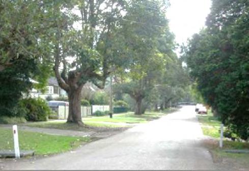
The following additional controls apply to infill development within a heritage conservation area.
Infill development includes the construction of a new building on a property within a heritage conservation area, which may come about by subdivision or replacement of a non-characteristic building.
Desired Outcome
a. Contemporary design is sympathetic to the character of the heritage conservation area, particularly in terms of bulk, scale, height, form or materials.
Prescriptive Measures
a. The design of new infill buildings in heritage conservation areas should be guided by the guideline documents ‘Design in Context’ by NSW Heritage Office (2005) and ‘Better Placed – Design Guide for Heritage’ by the Heritage Council of NSW (2019).
b. The design of new and replacement buildings should sympathetically respond to the scale, form, siting, roofs, materials, colours, and detailing of surrounding characteristic elements, particularly where there is a general consistency in the building scale within the streetscape and heritage conservation area.
c. The setback of new buildings to the street should maintain the established historically significant pattern of setbacks in the streetscape.
d. New buildings should be sited to reinforce the rhythm and spacing of buildings in the heritage conservation area.
e. The bulk and scale of new development should be consistent with the key historic elements of the heritageconservationareaandrespondto thescale, form, and typology of surrounding characteristic development. If characteristic development is single-storey, new buildings should also be singlestorey.
h. On corner sites, the new building should be designed to address the street corner and respond to the form, scale, and articulation of historical corner buildings within the heritage conservation area.
i. Uncharacteristic or faux period elements and features should be avoided.
Desired Outcome
a. Senior housing developments contribute positively to the area’s heritage significance and character.
Prescriptive Measures
a. Any proposed demolition for seniors housing development should be comprehensively justified per Sections 9.4.2 and 9.6.2.
b. Garages, carports, and resident carparking spaces should not be visible from the public domain.
c. The landscaped front and side setbacks visible from the public domain should not be divided into or form part of private open space.
d. Communal open space in the landscaped front setbacks or public domain visible side setbacks should be open and not fenced, walled, or hard screened. Plantings can be used to establish boundaries and achieve privacy.
f. Infill development should align with the height of existing adjoining development that is characteristic of the conservation area.
g. Within groups of buildings such as rows of shops, infill building and façade design should respond to the scale, materials, and massing of heritage items byaligningeavelines,cornicesandparapets,façade articulation, proportion and/or rhythm of existing elements, and use complementary colours, materials, and finishes.
The following section provides background information and additional development controls specific to the Beecroft-Cheltenham Heritage Conservation Area. The controls in this section are in addition to the general controls for all heritage conservation areas found in Section 9.6. The Beecroft-Cheltenham Heritage Conservation Area Comprises five precincts, each with a distinct collective nature of characteristics that make up the heritage conservation area’s value and significance.
Development in each precinct should have regard for both the general controls and the specific controls below. Where there is conflict between sections, the specific controls will prevail.
The Beecroft-Cheltenham Heritage Conservation Area is significant as an example of a government subdivision thatwas used tofund the development of a railway line. The area developed from 1893 as a township due to its proximity to Beecroft Station.
The Heritage Conservation Area demonstrates a multi-layered history of suburban subdivision, resubdivision, and development from the initial boom period of the Victorian crown land subdivision of 1887 to the 1960s and less noticeably to the present day.
The area contains a fine collection of buildings from the Victorian, Federation, Arts and Crafts, InterWar, and Post-War eras. There have been comparatively few demolitions to interrupt the “development diary”, resulting in generally intact early residential fabric and streetscapes.
The Beecroft Heritage Town Centre has historic value as the main connection between Beecroft Station and the suburbs to the west. It contains an important public reserve and community buildings, including the Beecroft School of Arts and the Beecroft War Memorial, that collectively represent the aspiration of a growing suburb. The continuing focusintheBeecroftvillageforday-to-dayactivities and community interaction, together with the community buildings,clubs,and activities,show an enduring sense of community cohesiveness.
While the overall historic streetscape character in Beecroft North and the Northern Triangle has been eroded by late twentieth-century and contemporary infill development, the undulating topography, road network, subdivision pattern, building siting and orientation which respond to the landform, building setbacks, garden setting of the dwellings, and the remnant bushland features such as landforms and landscaping all contribute to the aesthetic significance of the place.
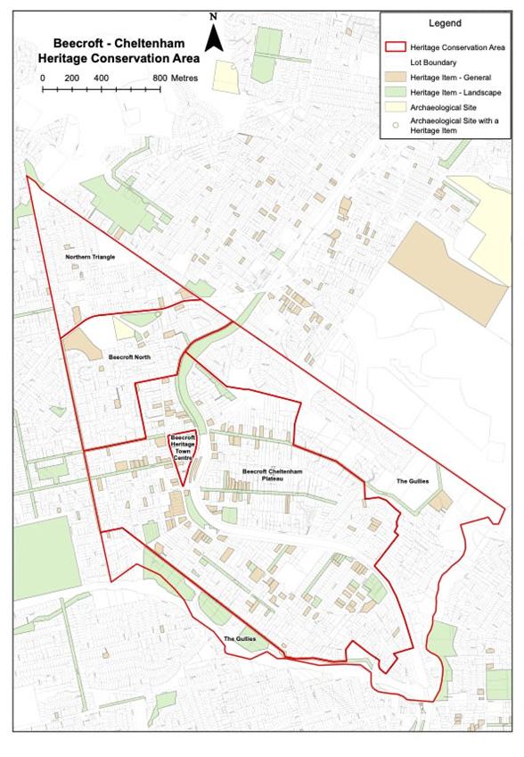
Summary History
The Beecroft Heritage Town Centre lies wholly within Sections 5 and 6 of the ‘Beecroft Platform’ subdivision sale, which dates from 9 July 1887.
Conveniently located at Beecroft Station, this precinct developed to service the growing residential population in Beecroft and Cheltenham. By the turn of the century, there was a flourishing shopping area, including a butcher, grocer, estate agent, haberdashery, bakehouse, shoe repairer, and chemist. The retail area adjoining Beecroft Station continued to develop in the Pre-War period to include two greengrocers, a dentist, and two motor garages.
In 1904, Section 6 of the Beecroft Platform subdivision was substantially re-subdivided, and 14 allotments were advertised for auction sale in Hannah Street, Railway Crescent, and Beecroft Road, forming retail and residential sites.
ThelocalshoppingcentreflourishedintheInter-Warand Post-War periods. New shops and retail services were built throughout the precinct, including, in 1961, the Beecroft Village Arcade, with its own carpark, along the northern side ofHannah Street. New subdivisions in The Gullies Precinct in the 1960s increased the residential population and impacted retail development at Beecroft Heritage Town Centre. There were clothing stores, an antiques shop, arts and music stores, grocery and food stores, and retailers such as banks, chemists, a drycleaner, hairdressers, and health services.
A new shopping centre, the Module complex, was built in 1972, complete with its own carpark. The Beecroft Village Arcade was expanded at about the same time.
The most recent wave of development was in 2017 and comprised the construction of Beecroft Place, a medium-density mixed-use development on the corner of Hannah Street and Beecroft Road. It included 27 retailers (including Woolworths) with 130 apartments above.
The Beecroft Heritage Town Centre extends on either side of the railway line and Beecroft Road. The plateau incorporates the early boundaries of the Field of Mars Common subdivision.
The earliest development occurred near Beecroft Station from 1898, comprising Victorian villas with modest and large domestic gardens that have become characteristic of the area’s streetscape.
The main building styles found in the precinct include Victorian, Federation, Inter-War, Post-War, and infill development from later periods.
Buildings are predominantly single-storey in scale.
Stone foundations, face brick with rendered detailing of small areas, and terracotta or slate tiled roofs are typical.
Mature trees, including remnant forest trees, combine to create a landscaped character. The gardens and private domain plantings contribute to this character.
The Beecroft Heritage Town Centre is Beecroft’s historic commercial centre.
The precinct is within the land of the first Crown subdivision and retains the subdivision pattern.
The precinct is the commercial heart of Beecroft, developed as a result of its proximity to the railway station in the late 1890s and early 1900s to serve the growing local population.
The Beecroft School of Arts, Fire Station, and Village Green create a strong gateway to the precinct.
Some remnant historic residences and shops from the Federation to the Inter-War period have been retained, but their integrity has largely been compromised by unsympathetic additions and removal of characteristic features.
The precinct consists of late twentieth-century and contemporary commercial and mixed-use multistorey development, which has introduced contemporary forms and materials and compromised the historic architectural quality of the streetscape, including the building orientations, small lot sizes, and low scale.
The northern portion of the precinct is the ‘residential area’, while the southern portion, including sites on both sides of Hannah Street, is the ‘commercial area’ of the precinct. This is reflected in the LEP zoning, height, and floor space ratio controls for the two areas.
a. The historic streetscape character within the Beecroft Heritage Town Centre is conserved.
b. The contribution of the heritage items and characteristic buildings to the heritage streetscape is conserved.
c. Modifications to buildings are of an appropriate design that does not adversely impact the significance or character of the precinct.
d. New development is in keeping with the historic elements of the desired future streetscape character and does not adversely impact on the significance or character of the heritage town centre.
e. A historic streetscape character with a consistent pedestrian scale street wall, awning height, and parapet line is retained.
f. The streetscape is activated with a diverse range of commercial and cultural activities compatible with the significance of the heritage town centre.
g. The historic building alignment along Wongala Crescent, Hannah Street, and Beecroft Road is interpreted through consistent setbacks within the commercial area.
h. Carpark entries and basement carparks are located and designed to not dominate or impact the streetscape character of the heritage town centre.
Prescriptive Measures
Table 9.7-a: Additional Prescriptive Measures – Beecroft Heritage Town Centre Provisions
Element Additional Prescriptive Measures
Architectural Style Significant changes to front elevations should be avoided where a heritage item or a contributory building retains detailing characteristic of the heritage town centre.
New development should be well articulated and reference the proportions, fenestration pattern, and vertical rhythm ofheritageitemsorcontributorybuildings.
Element Additional Prescriptive Measures
pedestrian scale within the historic streetscape.
New development should reflect the historic patternofsetbacks and contribute to the character of the streetscape.
Infill buildings should be sympathetically designed to respond to the bulk, scale, height,form,proportions,and materials of the heritage town centre.
Security and services Security to shopfronts should complement the architectural style/period of the town centre, such as the use of collapsible lattice gates.
Carparking and driveways
Siting New development should be sited to reflect the historic subdivision pattern, historic pattern of setbacks, and street orientation.
Corner sites should be designed to address the street corner and respond to the form, scale, and character of historical corner buildings in the precinct.
Scale and form Retain the predominant pattern, scale and form of one or two storey development at the street frontage, to maintain the
Shopfronts
Intrusive elements on shopfronts such as roller shutters and air conditioning units should be removed and re-installed where they are not visible from the streetscape.
Basement carparks, garages, and loading docks should not be located adjacent to a heritage item or contributory building.
Driveways should be avoided along Hannah Street.
Vehicular entrances and vehicular infrastructure (i.e., boom gates, ticketing machines, etc) should be set back 6m behind the front street boundary, or the front façade of a heritage item or contributory building.
Roller doors to basement carparks should not be visible from the street.
Original shopfronts should be retained.
Non-original shopfronts should be replaced with new shopfronts that respect the historic character.
New shopfronts should be designed with suspended, traditional steel box-section awnings over footpaths.
Continuous, original, and early awnings should be retained.
Non-original awnings should be removed and replaced with awnings designed to interpret and respect the historic character of the precinct.
Shopfronts shouldnot becovered bysolid roller doors or security screens.
Signs
Signs should be located on parts of the building that have traditionally been used for signs or advertising areas.
Above awning signs should be avoided, except where part of the original design.
Signs on shop windows should not exceed 25% of the total area of the shop front glazing.
Summary History
This precinct lies within the boundaries of the Field of Mars Common. Subdivision of the area commenced in the 1880s, with the first sale of allotments at ‘Beecroft Platform’ taking place on 9 July 1887. This subdivision comprised 20 allotments in Sections 1 to 8 bound by the railway line to the east, Kirkham Street in the south, Castle Howard Road and Hull Road to the west, and Malton Street to the north.
Approximately 70% of the land was taken up at the first sale of the Field of Mars Common, and houses first appeared in the area in 1887. By 1891, there were at least 48 occupied houses in the area, including Victorian villas, small cottages, and orchard cottages.
Development of the area initially centred on the railway platform at Beecroft. Housing spread southwards from Beecroft from 1898 when Cheltenham Railway Station was established following community pressure led by local resident William Chorley. Home building and population in the Plateau area increased from the late 1890s and peaked in the Federation period before World War I.
The original large allotments and villa properties were progressively subdivided, and Federation cottages proliferated in the area. Some of the re-subdivisions in this period include Beecroft-Cheltenham in 1906, Ramona Estate (1911), Wandeen Estate (1913), Herring Estate (1914), Springfield Estate (1913), and Eaton Park (1915).
Building covenants informed the quality/value, maintained one house per lot, and stipulated building in brick or stone with Marseilles tile roofs set in manicured garden settings.
There was a burst of Inter-War and Post-War residential development on the plateauarea mirroring development trends and architectural typologies across the Sydney region more broadly. The precinct features layers of suburban subdivision, re-subdivision, and development from the original Victorian period of Crown land subdivision of the Field of Mars Common to the 1960s and through to the present day.
modest and large domestic gardens that have become characteristic of the area’s streetscape.
The main building styles found in the precinct include Victorian, Federation, Inter-War, Post-War, and infill development from later periods.
Buildings are predominantly single-storey in scale.
Stone foundations, face brick with rendered detailing of small areas, and terracotta or slate tiled roofs are typical.
Mature trees, including remnant forest trees, combine to create a landscaped character. The gardens and private domain plantings contribute to this character.
The Beecroft–Cheltenham Plateau has a high level of integrity that has not been significantly impacted by recent development.
Desired Outcome
a. Modifications to buildings within the Beecroft/Cheltenham Plateau Precinct are of an appropriate design that does not adversely impact the significance or character of the precinct.
Prescriptive Measures
Table 9.7-b: Additional Prescriptive Measures – BeecroftCheltenham Plateau Precinct Provisions
Element Additional Prescriptive Measures
Demolition Buildings from the Victorian, Federation, Edwardian, Inter-War, and Post-War periods should be retained.
Subdivision Minimise subdivision where possible to retain the pattern from the original Victorian period of Crown land subdivision of the Field of Mars Common.
Streetscape character
The predominantly single-storey scale should be retained.
Articulation should break up building mass using elements such as bay windows and verandahs.
Hipped and gabled roofs should be used.
Scale The predominantly single-storey scale should be retained.
Materials and finishes
Character Statement
TheBeecroft/CheltenhamPlateauPrecinctextends oneithersideofthe railwaylineandBeecroftRoad. The plateau incorporates the early boundaries of the Field of Mars Common subdivision.
The earliest development occurred near Beecroft Station from 1898, comprising Victorian villas with
Garages and carports
Clean facedbrick should be used for walls. Terracotta tiles or slate should be used for roofs.
Render, shingles, and timber joinery should be used for small areas or feature elements.
Stone or other treatments should be used to distinguish base or foundation level.
Garages and carports should have pitched roofs.
Summary History
The Beecroft North Precinct lies within the Field ofMars Common. Subdivision in the precinct took place in the 1880s, with the western portion comprising Crown allotments advertised for sale by auction in August 1887 and the northeastern sector in December 1893.
These two subdivisions of the Field of Mars Common comprised larger allotments than those created in the BeecroftVillagesubdivision.Atotalof115portionswere advertised for sale on 27 August 1887, ranging in size from ½ an acre to over 4 acres. Similar-sized allotments were offered for sale in the December 1893 auctions.
Large parts of this precinct remained undeveloped until the Post-War period. A feature of the precinct until the 1960s was substantial pockets of remnant bushland.
Landholdings in the area were subdivided in the 1960s, conforming to the undulating topography and preserving some of the remnant bushland.
The most recent development continues the general pattern of re-subdivision and architectural development of substantial late twentieth-century brick contemporary houses characteristic of Sydney’s northwestern suburbs.
Character Statement
The topography of the Beecroft North Precinct is precipitous.
The predominant subdivision pattern and development responded to the topography and is largely from the mid-twentieth century.
The precinct is characterised by detached lowscale housing on large blocks with formal gardens, mature trees, and low front fences.
The precinct has a mix of housing from the mid to late twentieth century and early twenty-first century. Some earlier Federation bungalows are scattered throughout the precinct, and some properties have undergone subdivision.
a. New development within the Beecroft North Precinct retains the significance and historic character of the precinct.
Prescriptive Measures
Table 9.7-c: Additional Prescriptive Measures – Beecroft North Precinct Provisions
Element Additional Prescriptive Measures
Demolition Buildings from the Victorian, Federation, Edwardian, Inter-War, and Post-War periods should be retained.
Subdivision Minimise allotment subdivision to retain the pattern from the original land subdivision.
Streetscape character
Materials and finishes
The predominantly single-storey scale should be retained.
Retain detached low-scale housing on large blocks with formal gardens and mature trees and fronted by low fences.
New development should step down sloping sites to complement the natural topography of the site and the surrounding environment.
Articulation should break up building mass using elements such as bay windows and verandahs.
Hipped and gabled roofs should be used.
Face brick, rendered masonry or weatherboard should be used for walls.
Terracotta tiles should be used for roofs.
Summary History
This precinct lies within the Field of Mars Common. Lying on the steep slopes of Devlins Creek and Byles Creek catchment areas east and west of the main Beecroft-Cheltenham Plateau, these areas were subdividedintolargerportionsandadvertisedforauction sale as part of several subdivisions, principally in August 1887, March 1888, and June 1891. The land in this area was not considered suitable for farming or orchards, nor was it attractive for residential development, given the difficult terrain.
Development in Beecroft and Cheltenham tended to conform to the ridge lines until as late as the 1960s, so the land in this area remained largely undeveloped until this time.
New release allotments at Cheltenham in late 1958 boasted a ‘beautiful bushland setting…5 minutes station’ with ’55ft frontages’. Ten yearslater, ¼ acre lots featuring a ‘glorious bushland setting with magnificent views’ were promoted for sale at Cheltenham Heights by Hooker-Rex Pty Ltd. The Cheltenham Gardens Estate offered eight large blocks in a ‘peaceful bushland setting’ off Day Road between Day Road and Cheltenham Road in 1969, with some level blocks and others ‘sloping and offering interesting scope to the modern architect’.i
The Gullies Precinct area, previously unattractive to buyers,becameadesirablesettinginwhichtobuild.The ‘Late Twentieth Century Sydney Regional’ school of architecture favoured building on rugged, natural, steeply sloping sites and retaining natural bushland around houses. Master Builders such as Pettit + Sevitt and Lynton Constructions Pty Ltd built exhibition homes in this area. There was also a Hooker Rex estate with a Master Builders Group 4 homes centre featuring nostalgic and contemporary designs by Haines, Maxwell, Maas, and Hooker.
This area is defined by steep topography and retained native bushland and is characterised by significant mature trees and dense tree canopy.
The road network and subdivision pattern are a result of the steep topography of the place, with roads following prominent ridgelines in the area.
Development is largely from the mid-twentieth century onwards. The houses are generally sited back from the road due to the steep topography. Some more recent subdivision has occurred, limiting visibility from the street due to the topography and tree canopy.
The housing is a mix of mid to late twentiethcentury and early twenty-first-century, with some prominent architect-designed Sydney School style dwellings present in the area.
The orientation and siting of the dwellings within theirallotment is notconsistentacross the precinct and generally responds to the lot’s topography. The dwellings are set amidst formal gardens and considerable plantings.
a. New development within The Gullies Precinct retains the significance and historic character of the precinct.
Prescriptive Measures
Table 9.7-e: Additional Prescriptive Measures – The Gullies Precinct Provisions
Element
Demolition
Subdivision
Streetscape character
Additional Prescriptive Measures
Buildings designed by Sydney School architects should not be demolished.
Minimise subdivision where possible to retain the original land subdivision pattern.
Retain the remnant bushland and mature trees thatcontributetodensetreecanopy.
Summary History
The Northern Triangle Precinct lies within the Field of Mars Common. The area was advertised for sale by auction in March 1888 and December 1893.
The area was sparsely developed following the subdivision and was largely occupied by farms, dairies, and orchards. It remained substantially rural until the 1960s.
The initial residential subdivision in the precinct comprised land fronting Killaloe Avenue and Victoria, Loftus, and Pennant Hills Roads in the 1920s. The transition from farming to suburban allotments and the successive waves of development throughout the area continued throughout the 1950s and 1960s.
The precinct has undergone a ‘new wave’ of housing development from the late twentieth century to the present. This wave has been characterised by the ‘knockdown and rebuild’ of houses on many blocks throughout the area and occasional townhouse developments and battle-axe blocks.
Character Statement
The precinct is characterised by mid to late twentieth-century and contemporary infill development comprising detached houses set within formal gardens with well-established trees on private property and public domain.
The precinct exhibits some consistency in low-scale residential development, setbacks, building siting, orientation, materiality, large lot sizes, garden setting, and native and cultural plantings.
The undulating landscape has an irregular subdivision pattern with varying lot sizes.
Large Federation houses are located along Pennant Hills Road and Boundary Road and at the southern end towards Chapman Avenue.
a. New development within The Northern Triangle Precinct retains the significance and historic character of the precinct.
Prescriptive Measures
Table 9.7-d: Additional Prescriptive Measures – The Northern Triangle Provisions
Element Additional Prescriptive Measures
Demolition Buildings from the Victorian, Federation, and Edwardian periods should be retained.
Subdivision
The remnant forest canopy is important to the area’s character.
Streetscape character
Minimise subdivision where possible to retain the original land subdivision pattern of the Field of Mars Common.
Retain detached low-scale housing on large blocks with formal gardens and mature trees.
Retain the bushland setting, including the remnant bushland and mature trees that contribute to dense tree canopy.
Materials and finishes Materials and finishes should synthesise with the general built character of the precinct.
The following section provides background information and additional development controls specific to the Hornsby West Side Heritage Conservation Area. The controls in this section are in addition to the general controls for all heritage conservation areas found in Section 9.6.
The Hornsby West Side Heritage Conservation Area comprisesthreeprecincts,eachwithadistinctcollective nature of characteristics that make up the heritage conservation area’s value and significance.
Development in each precinct should have regard for both the general controls and the specific controls below. Where there is conflict between sections, the specific controls will prevail.
Cross References to Other Sections Control
9.1 Introduction
9.4 Heritage Items
9.5 Landscape Heritage
9.6 Heritage Conservation Areas – General
Peats Ferry Road Precinct is significant for its association with the development of Hornsby Shire as a railway town and its role within the old town centre. The area is historically and socially significant as an extant example of the earliest commercial precinct in Hornsby Shire. It contains a fine collection of Federation and Inter-War period commercial and civic buildings.
Mount Errington Precinct demonstrates the historic development of Hornsby Shire, with surviving evidence of early development. Houses and gardens from the Federation and Inter-War periods and the landscape contribute to quality streetscapes. The dramatic setting contributes to a high level of aesthetic significance, with bush encircling the area on three sides providing a green backdrop that is reinforced by the dominant tree canopy of remnant and regeneration forest.
Pretoria Parade Precinct is an example of an early nineteenth-century subdivision form that has a consistent pattern of modest single-storey houses.
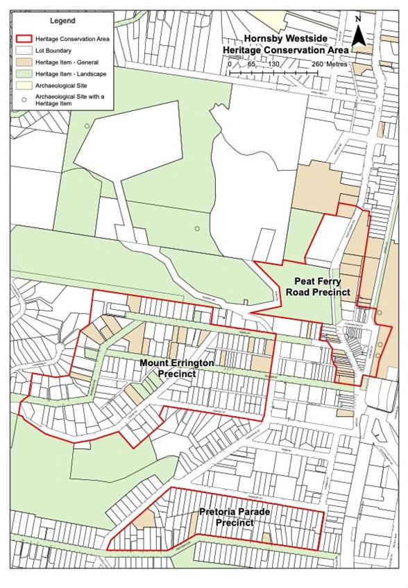
Otherwise known as Hornsby Heritage Town Centre.
Summary History
Around1840,GeorgePeat,ashipchandler,commenced a ferry crossing between either side of the Hawkesbury River, where he was granted land.
Peats Ferry Road was constructed between 1847 and 1852 to facilitate an alternative route to the north. The new road connected the ferry wharf with Pearce's Corner. The government adopted this track as an official route and improved it for traffic in 1848 when it supplanted the Great North Road as the direct road link from Sydney to the north. Between 1925 and 1930, the Main Roads Board constructed Peats Ferry Road as a new sealed road from Hookham's Corner at Hornsby to Peats Ferry.
The western side of the railway station had developed by this time as a business centre at Hornsby Railway Junction. Shops and businesses provided a range of services for the township and the surrounding rural districtwestofHornsby Shire across the Galston Gorge. This was the principal transport hub for farmers and orchardists in that district.
In the 1890s, Hornsby Shire became a busy goods yard and transport centre servicing the orchardists transporting fruit from farms in the Dural district, a trip shortened by the construction of the Galston Gorge Road and bridge.
Subdivisions anticipated this growing need for shops and services, and owners/developers advertised allotments for business sites and premises to serve the community in and around Peats Ferry Road. For instance, in June 1926, nine lots were offered for sale ‘right in the heart of the town and close to the railway station’.ii
Land to the west of the railway line along Peats Ferry Road north of Coronation Street assumed a civic administrative character from the Federation period when the Police Station (1909), Post Office (1911), Council Chambers (1915), and Court House (1926) were built, all on Peats Ferry Road.
The area has been subject to some contemporary infill developments that have impacted the historic streetscape character.
Desired Outcomes
a. The historic streetscape character within the Peats Ferry Road Precinct is conserved.
b. The contribution of the heritage items, contributory buildings, and historic laneways to the heritage streetscape are conserved.
c. Shopfronts and the character and historic fabric of second-storey facades above shopfronts are retained and conserved.
d. New development demonstrates design excellence and retains the significance and character of the Peats Ferry Road Precinct.
e. A historic streetscape character with a consistent street wall, awning height, and parapet line within the commercial core is retained.
f. To ensure that new development retains and complements the character of the precinct in terms of siting, scale, form, architectural detailing, and materiality.
g. To interpret the historic streetscapes in accordance with the Hornsby Shire Interpretation Strategy through materiality, signage, and public art.
Prescriptive Measures
Table 9.8-a: Additional Prescriptive Measures – Peats Ferry Road Precinct Provisions
Element
Demolition Retain all Federation shops and civic buildings.
Architectural Style
Character Statement
The precinct is characterised by Federation and Inter-War shopfronts and civic buildings, such as the Police Station and the Council Chambers.
The precinct comprises three main areas: the ‘commercial core’, the ‘commercial area’, and the ‘civic, education, and community area’. Each area consists of varying uses within the precinct.
Scale and form
Significant changes to front elevations should be avoided where a heritage item or a contributory building retains detailing characteristic of the heritage town centre.
New development should be well articulated and reference the proportions, fenestration pattern, vertical rhythm, and datums of heritage items or contributory buildings.
Retain the predominant pattern, scale, and form of two-storey development at the street frontage to maintain the pedestrian scale within the historic streetscape. New development should reflect the historic pattern of setbacks and contribute to the character of the streetscape.
Infill buildings should be sympathetically designed to respond to the bulk, scale, height, form, proportions, and materials of the heritage town centre.
Details and original features
Originalarchitecturaldetailingandfeatures to street elevations, such as finials, trims, windows,balconies,andawningsaretobe retained and conserved.
Modified or infilled balconies on contributory buildings should be reinstated.
New developments above heritage items and contributory buildings should not include largeopeningsandareasofglazing for windows and glazed balustrades.
Windows and balconies in new development should respond to the pattern and arrangement of openings on heritage items or contributory buildings within the Precinct.
Existing incompatible/intrusive elements (e.g., non-original aluminium windows and doors, aluminium or vinyl cladding) in street elevations and prominent locations must be replaced with traditional materials when alterations and additions are proposed.
Services Elements such as solar hot water heaters, ventilators, antennae, solar tubes, air conditioning units and the like should, where possible, be placed in locations where visibility from the street is minimised, such as placing services on roof planes that do not face a roadway or street frontage.
Upgrade or replacement of existing services (e.g., air conditioning units, roller shutters, and meter boxes) located on frontelevationsofcontributorybuildingsor heritage items should not be visible from the public domain.
Shopfronts Original shopfronts and other significant elements of original façades (e.g., windows, balconies, and detailing) should be retained.
Continuous, original, and early awnings should be retained. Non-original awnings should be removed and replaced with awnings designed to interpret and respect the historic character of the Precinct.
Glazing to new commercial shopfronts should respect and interpret the historic character of the commercial core or commercial area.
Shopfronts must not be covered by solid roller doors or security screens.
Signs
Fences and gates
Signs should be located on parts of the building that have traditionally been used for signs or advertising areas.
Above awning signs should be avoided, except where part of the original design.
Signsonshopwindowsshouldnotexceed 25% of the total area of the shop front glazing.
Non-originalshopfrontsshouldbereplaced with new shopfronts that respect and interpret the historic character of the Precinct.
Where commercial lots have been amalgamated, shopfronts should retain the historic streetscape pattern of individual shopfronts.
New shopfronts should be designed with suspended, traditional steel box-section awnings over footpaths.
Carparking and driveways
Fencingandgatesshouldbeavoidedalong Peats Ferry Road and Coronation Street within the commercial area and commercial core.
Fencing and gates are permitted along Station Street.
Basement carparks, garages, and loading docks should not be located adjacent to a heritage item or contributory building.
Vehicular access to the commercial area andcommercialcore shouldbe fromarear laneway, where possible.
Future vehicular access to the commercial core should utilise the existing laneway on Station Street.
Vehicular entrances and vehicular infrastructure (i.e., boom gates, ticketing machines, etc) should be set back 3m behind the front street boundary, or the front façade of a heritage item or contributory building.
Roller doors to garages and basement carparks should not be visible from the street.
Laneways
Public domain
The existing laneways should be retained. Through-site links should not be introduced between a group or pair of heritage items or contributory buildings.
New development should include public domain enhancement, including retaining and activating laneways, soft landscaping, and high-quality palette of materials reflecting the historic character of the Precinct.
Summary History
Part of the present Mount Errington Precinct was subdivided in 1886 by Burns, Smith, and Withers at Hornsby Junction. This included land in Dural Street, William Street, Ashley Street, and Frederick Street. A decade later, on 12 December 1896, 0.5 to 0.75-acre allotments were offered for auction sale at Mount Errington, Hornsby Junction, west of the 1886 subdivision. Allotments fronted Lisgar Road, Rosemead Road, William Street, Dural Road, and Ashley Street.
The following year (1897), Anne Roberts, the wife of Oscar Garibaldi Roberts, purchased 1.5 acres of land at the corner of Rosemead Road and Dural Street and erected a large house called ‘Mount Errington’. Roberts was the co-owner of Fairfax and Roberts Jewellers of Sydney. Roberts subdivided the property in October 1913. By this date, there were several houses dotted throughout the area and following the 1913 subdivision, Federation and Inter-War homes were erected on these new 23 lots.
Character Statement
The topography of the area is steep, and properties along Dural Street and Lisgar Road are located on steep slopes.
The underlying historic subdivision arrangement and pattern are evidenced.
The landform and mature street plantings contribute to the setting.
Dwellings generally retain their landscape setting, including gardens and plantings.
The dominant building typology that characterises the precinct dates from the Federation and InterWar periods.
Contemporary residential developments have compromised the character of the HCA. Nonetheless, generally, these dwellings have retained the prevalent subdivision pattern of the precinct, overall historic character, and garden setting.
a. To ensure new development, including alterations and additions, to buildings within the Mount Errington Precinct retains the significance and historic character of the precinct.
Prescriptive Measures
Table 9.8-b: Additional Prescriptive Measures – Mount Errington Precinct Provisions
Element
Additional Prescriptive Measures
Demolition Retain original houses from the Victorian, Federation, and Inter-War periods.
Subdivision Retain detached low-scale housing on large blocks with formal gardens and mature trees.
Scale and form Retain the dominant single-storey scale and character of the precinct.
Front setbacks should be determined from adjoining buildings constructed prior to the 1960s.
Gardens and landscaping
Retainthebushlandsettingincludingmature plantings and existing significant gardens.
New developments should not adversely affect the visual appreciation of the natural topography.
New development along Dural Street and Lisgar Road should complement the natural topography of the site and the surrounding environment.
Materials and finishes Face brick (red and brown colours) and weatherboards should be used for walls.
Rock faced stone should be used for basement walls or foundations.
Renderingorpaintingofbrickwork,ortimber joinerycanbeusedforsmallareasorfeature elements. Lighter colours can be used as highlights to emphasise particular parts of the building. Deeper colours may be used as trim.
Terracotta tiles or slate with ridge and ornamental end cappings should be used for roofs. If corrugated metal is used for small ancillary areas, lighter colours of silver or green should be selected.
Fences and gates
Newfencesvisiblefromthestreetshouldbe primarily constructed of timber, unless historic documentation indicates alternative original materials were once used.
Summary History
Following the construction of the North Shore and Northern railway lines to Hornsby Junction, developers/speculators Burns, Smith, and Withers subdivided land west of the Northern Line in 1903 into blocks of one acre and upwards. Pretoria Parade was described in the sales advertisement as a ‘direct road (formed and metalled) from the station—only a few minutes’ walk'. The auction attracted about 500 people, but only about half a dozen blocks were sold, and ‘lots on the good level ground did not reach the desired reserve price’.iii
Further sales took place in the Mount Pretoria Estate over the following years. Portions of the estate were advertised for sale as late as August 1924. In the intervening period, owners commenced re-subdivision of their land, such as the Reddy Estate in April 1910, comprising31allotmentsalongthenorthsideofPretoria Parade and the south side of Nursery Street. WJ Black was responsible for at least two separate subdivisions of parts of the Mount Pretoria Estate fronting the south side of Pretoria Road.
Some of the larger blocks have been re-subdivided into battle-axe blocks in the last half-century. There has also been some contemporary infill development.
Character Statement
Pretoria Parade runs along the ridgeline, with the landform falling away to the north and south. Both sides of Pretoria Parade consistoflow-scale singlestorey detached Federation or Inter-War bungalows located on narrow lots with a regular subdivision pattern, with some modern infill development.
The Federation and Inter-War bungalows comprise forms and features typical of the period, including tiled pitched roofs with chimneys, projecting gables to the primary façade with timber bargeboards, front verandahs with timber joinery, and timber-framed windows. They are set within small gardens and have a consistent building alignment parallel to the street and front and side setbacks.
intactness. Some battle-axe subdivisions have occurred along Pretoria Parade.
Desired Outcome
a. To ensure that modifications to buildings within the Pretoria Parade Precinct are of an appropriate design that does not adversely impact the significance or character of the precinct.
Prescriptive Measures
Table9.8-c: Additional Prescriptive Measures– Pretoria Parade Precinct Provisions
Element Additional Prescriptive Measures
Demolition Buildings from theFederation and Inter-War periods should not be demolished.
Subdivision Altering the existing subdivision pattern through subdivision, amalgamation or boundary adjustments should be avoided, unless the resulting development reflects theestablishedcharacterofsingledetached dwellings on separate allotments.
Retain historic estates that represent the early pattern of development.
Battle-axe subdivisions should be avoided along the precinct.
Scale and form
Retain the dominant single-storey scale and character of the Precinct.
New development, alterations, and additions should be consistent with the existinguniformfrontandsidesetbacksand building alignment.
Architectural Style
New development, alterations, and additions could include architectural features including pitched roofs and open verandahs.
The streetscape is generally cohesive due to the uniform subdivision pattern and the buildings’ setbacks, alignment, low scale, architectural form and features, and garden setting. While some characteristic dwellings have undergone modifications, and the streetscape consists of some unsympathetic late twentieth-century and contemporary dwellings, the overall streetscape shows good levels of consistency, integrity, and
The following section provides background information and additional development controls specific to The Crescent, Pennant Hills Heritage Conservation Area. The controls in this section are in addition to the general controls for all heritage conservation areas found in Section 9.6. Development in this area should have regard for both the general controls and the specific controls below. Where there is conflict between sections, the specific controls will prevail.
station, was advertised for auction sale by the Intercolonial Investment Land & Building Company. The CumberlandArgusandFruitgrowersAdvocatereported on 21 October 1905 that ‘there was a large and satisfactory attendance at the sale…[and] pretty well all the frontage lots were disposed of, and the prices realised generally were very satisfactory, ranging from £1 to £3 15s per foot’.iv
Pennant Hills was not listed in the SandsDirectoryuntil after 1910. However, there was very little development in the estate at this time. By 1915, there were eight houses listed in The Crescent, two in Britannia Street and four in Hampden Road. The level of developmenton the Blackacre Estate is shown in the 1930 and 1943 aerial photographs. More intensive development across the subdivision took place in the Post-War era, particularly on Hampden Road, outside the curtilage of the present HCA. Some of the large allotments were progressively subdivided, and battle-axe allotments formed along the eastern end of Britannia Street and Hampden Road and Cladden Close formed in the 1970s.
The Crescent HCA is located on part of 640 acres granted to George Henry Thorn on 15 April 1840. Part of the land grant was later acquired by Hannah and William Aiken and converted into an orchard known as Hillside.
InAugust1890,HannahAiken,thewifeofWilliamAiken of Pennant Hills, orchardist, conveyed 41 acres 3 roods of land at Pennant Hills to John Taylor Linger of the City of Sydney, Barrister-at-Law for the sum of £2353/7/4 (NSW Land Registry Services, OST Deed Bk 443 No 309).
Linger transferred the land in 1905 to The Intercolonial Investment Land and Building Company Limited (NSW Land Registry Services, CT Vol 992 Fol 181). That company subdivided the land as Deposited Plan 4592.
Linger promptly converted the land to Torrens title, which was subject to the right of Hannah Aiken and family to occupy the dwelling and other buildings on the land for six months from 11 August 1890 and the right to remove the buildings from land inthat time and to use the present orchard located on the land and harvest the fruit from the trees on the land for a period of five years.
On 14 October 1905, the Blackacre Estate, comprising large allotments fronting The Crescent, Hampden Road, Britannia Street, and Railway Streetopposite the railway
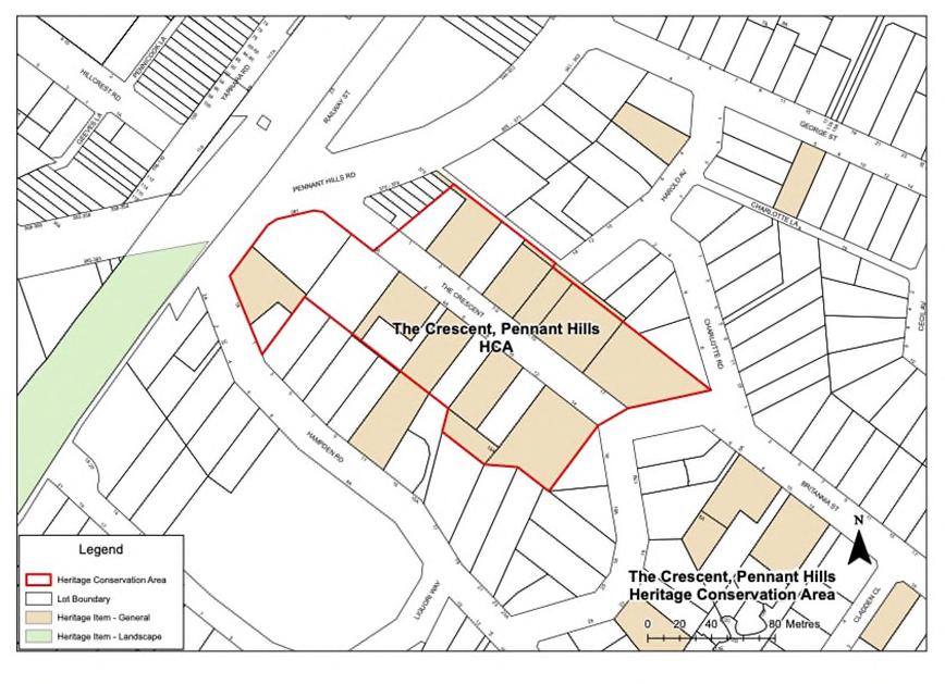
The Crescent Heritage Conservation Area is a very good example of a Federation subdivision with substantial, high-quality period homes, including Barncleuth (1909).
Character Statement
The physical context includes the landform, landscaping, and setting of the dwellings within formal gardens.
The landform rises gently from Pennant Hills Road before falling away sharply to the southeast and west at Britannia Street. The Crescent follows the slope with a high and low side.
The Crescent Heritage Conservation Area remains highly intact. Its substantial Federation houses form an intact and high-quality streetscape.
The areas to the east of the heritage conservation area comprise some good examples of Federation and Inter-War dwellings; however, the overall historic streetscape character has been compromised by a large number of Post-War, late twentieth-century, and contemporary dwellings.
Fences are typically low and constructed in stone, brick, and timber.
Garages on infill sites have been built to the street boundary.
Desired Outcome
a. Modifications to buildings within The Crescent Heritage Conservation Area are of an appropriate design that does not adversely impact the significance or character of the area.
Prescriptive Measures
Table 9.9-a: Additional Prescriptive Measures – The Crescent, Pennant Hills HCA Provisions
Element Additional Prescriptive Measures
Demolition Buildings from the pre-1940 period should be retained.
Streetscape character Retain detached low-scale housing on large blocks with formal garden settings.
Retain and conserve Federation and InterWar dwellings to preserve the historic streetscape.
Minimise garages, carports, and structures built to the street boundary.
Development should be single-storey.
Articulation should be used to break up building mass through the use of elements such as bay windows, entry gables, and front verandahs.
Materials and finishes New buildings should use materials that complement the traditional materials in the heritage conservation area.
Face brick, rendered masonry, and weatherboards are preferred.
Terracotta tiles or slate should be used for roofs.
Original roof materials should be replaced with traditional materials only, preferably the original material associated with the building.
Subdivision The existing subdivision pattern should be retained.
The following section provides background information and additional development controls specific to the Wahroonga Heritage Conservation Area. The controls in this section are in addition to the general controls for all heritage conservation areas found in Section 9.6. Development in this area should have regard for both the general controls and the specific controls below. Where there is conflict between sections, the specific controls will prevail.
The Wahroonga HCA occupies part of the land granted to John Terry Hughes in 1842. Subdivision, known as the Pearce’s Corner Township Estate, occurred in the late nineteenth century following the opening of the North Shore railway line. The land within the HCA was developed during the Federation and Post-War periods.
Pearce’s Corner Township Estate was advertised for auction sale on 15 October 1887, comprising 97 allotments in three sections fronting Lane Cove Road (present Pacific Highway), Isis Street, and Government Road (now Ingram Road). The sale was promoted by the National Building Land & Investment Co Limited. The DailyTelegraph reported that ‘a number of lots in the Pearce’s Corner Township [were sold] at prices ranging from 22s to £2 1s per foot’.v
Sales of unsold lots took place periodically over the next two decades, including in May 1893 and October 1900.
The remaining unsold allotments in Pearce’s Corner Township Estate were advertised for auction sale on 29 October 1910, with 50 choice residential and villa sites fronting Lane Cove Road, Peats Ferry Road, Ingram Street, and Isis Streetbetween the railway line and Lane Cove Road. On this occasion, various allotments were sold at prices ranging from £1 10s to 12/6 per foot frontage.
By 1915, there were 15 houses on the south side and 17 on the north side of Isis Street. It is likely there was a similar number of houses on Ingram Street, as well as development on Lane Cove Road and Peats Ferry Road, as recorded in the Sands Directory. The 1930 aerial survey shows residential development on the majority of allotments in the Pearce’s Corner Township Estate.
The south-eastern portion of the subdivision was resumed in the 1980s for the construction of the Pacific Motorway.
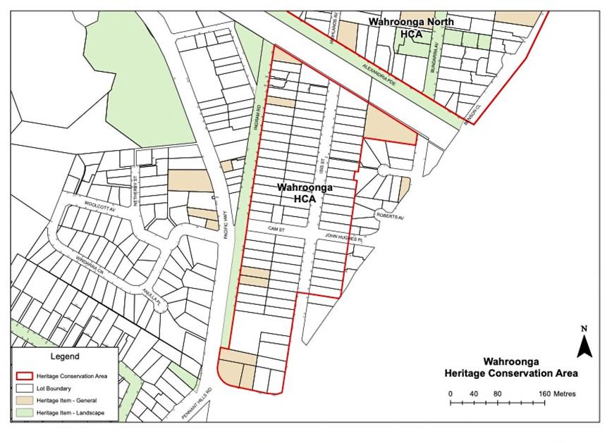
The Wahroonga Heritage Conservation Area is an example of a late nineteenth-century subdivision with a consistent built form of modest single storey houses. The area is closely associated with the construction of the North Shore railway line and Pearce’s Corner settlement.
Character Statement
The landform is relatively level, with slight falls to the east. The Pacific Highway and Ingram Street create strong boundaries to the west and south edges. The cutting to the railway line and M1 motorway are physical barriers to the north and southeast.
Buildings are typically single-storey with hipped and gabled roofs and verandahs to the street.
There are some two-storey Federation Arts and Crafts and Inter-War apartment buildings.
Timber weatherboard houses are contained within the area, especially along Isis Street, and strongly define the built character of the precinct.
The front gardens are well-planted and often have no fencing. Where fences occur, they are typically low and constructed of timber (some pickets), brick, timber posts and wire, brick and metal rail, and stone.
The area has a regular subdivision pattern that features similar-sized lots with consistent front setbacks. Some larger lots occur along the Pacific Highway. Changes and lot amalgamations have occurred to the underlying lot pattern associated with infill development.
Grass swales/verges along Isis Street and mature street planting of varying heights are prominent streetscape elements.
Common and characteristic building materials are weatherboard, fibro, brick, and roughcast render. Roofs are typically corrugated metal or terracotta tiles.
a. Modifications to buildings within the Wahroonga Heritage Conservation Area are of an appropriate design that does not adversely impact the significance or character of the area.
Prescriptive Measures
Table 9.10-a: Additional Prescriptive Measures – Wahroonga HCA Provisions
Element
Additional Prescriptive Measures
Demolition Buildings from the Federation, Edwardian, and Inter-War periods should be retained.
Subdivision Amalgamation and battle-axe subdivision should be avoided.
Scale and Form New work should continue the pattern of detached cottages with low pitched roofs and verandahs to the street.
The dominant single-storey scale and character should be retained.
New development and alterations and additions should be consistent with the uniform pattern of detached cottages with low-pitched roofs and verandahs to the street.
New developments should not adversely affect the visual appreciation of the natural topography.
Changes to the natural landform should be avoided.
Materials and finishes Weatherboard, brick or roughcast render should be used for walls.
Terracotta tiles and corrugated metal should be used for roofs.
New buildings should use materials that complement the traditional materials in the heritage conservation area.
Fences and gates Front fences should be low and constructed of timber (some pickets), brick, timber posts and wire, brick and metal rail, or stone.
Garages and carports Garages should be located behind the main building line and be designed with asymmetrical massing.
Driveways Concrete strip driveways should be used rather than full paved surface.
The following section provides background information and additional development controls specific to the Wahroonga North Heritage Conservation Area. The controls in this section are in addition to the general controls for all heritage conservation areas found in Section 9.6.
The Wahroonga North Heritage Conservation Area comprises two precincts, each with a distinct collective nature of characteristics that make up the heritage conservation area’s value and significance.
Development in each precinct should have regard for both the general controls and the specific controls below. Where there is conflict between sections, the specific controls will prevail.
9.6
The Wahroonga North HCA is associated with the subdivisions of the following estates:
Bundarra Estate, 1892, 1893, and 1895
Bundarra Estate (Ingalara portion), 1913
Wahroonga Heights Estate, 1926
Highlands Estate, 1933
Hordern Estate, 1938
Neringla Estate, 1950
While sales had been advertised in the area from the 1890s (Bundarra Estate), the focus of subdivisions and development was to the south and west of the area between the railway line and the Lane Cove Road (now Pacific Highway), around the developing Wahroonga Village.
Highlands at 9 Highlands Avenue is one of the earliest remaining houses in the area. It was built in 1892–93 for Alfred Hordern and his wife. A portion of the Highlands Estate was resumed in 1923 for the Waitara Public School, but the main subdivision of this estate took place in 1933. The 1938 subdivision of the Hordern Estate resulted in land for sale in Myra Street between
Oleander Road and Alexandria Parade, plus lots fronting the new Highlands Avenue.
The last major subdivision in this precinct was the Neringla Estate in 1950. In total, 17 allotments fronting Woonona, Fern, and Bundarra Avenues (including the brick residence Neringla on lots 1 and 2) were offered for auction sale on 30 June in this ‘exclusive residential area’.ii
There was some overlap in the area as part of the Bundarra Estate did not sell, so the area was subsequently re-subdivided. The area to the east of Woonona Avenue was part of a larger land holding and was not part of the subdivision pattern of the other areas.
The Wahroonga North Heritage Conservation Area is closely associated with the opening of the North Shore Railway line in the 1890s. It includes land in the early estates of the locality, Bundarra Estate (1892) and its subsequent Federation development. It also includes the Pre-War and Inter-War subdivisions of the Bundarra (Ingalara) Estate (1913), Wahroonga Heights Estate (1926), and the two divisions of the Highlands Estate (1933 and 1938) that led to the Inter-War and Post-War development of the area.
The area is strongly associated with significant local persons, including the Hordern Family and particularly the family matriarch, Caroline Hordern, and the Hordern Family Estate, which centred on their mansion, ‘Highlands House.’
The area is aesthetically distinctive, with a strong collection of Federation residential buildings. This includes ‘Highlands House’ (1892), ‘Neringla’ (1895), and ‘Cherrygarth’ (1897). The overlay of Inter-War and Post-War houses is unified and made complementary by the landscaped setting.
TheareaisimportantasareferencesiteforHornsby Shire, particularly in relation to the early development of the area. The area has the potential to reveal its pre-Victorian development and use through research.
The area demonstrates the post-1892 residential development of the area, exhibiting built and landscape qualities that are becoming rare within Hornsby Shire and which are endangered by continuing unsympathetic development.
Character Statement: Southern Precinct
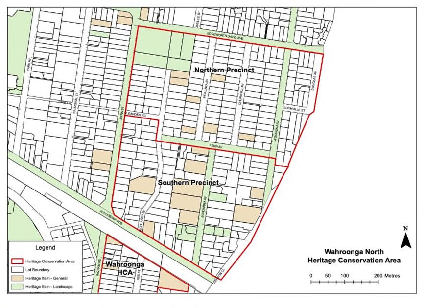
Character Statement: Northern Precinct
The Northern Precinct is fairly intact. The dwellings are typically small, single-storey buildings in garden settings.
The original subdivision pattern of narrow lots has been largely retained. It is characterised by InterWar and Post-War single-storey houses on narrow lots formed in the early suburban subdivisions. This pattern contributes to the streetscape quality.
The landform slopes down from the central plateau area around Highlands Avenue and Fern Avenue.
The housing stock around the south boundaries of the Precinct has been compromised by unsympathetic additions and alterations. Despite thedetractingdevelopmentalongbothsidesofFern Avenue, the tree canopies and streetscape contribute to the characteristic streetscape of Wahroonga North Heritage Conservation Area.
Character Statement: Southern Precinct
The dominant building types include Federation and Inter-War houses situated on substantial landscapedlots.Thehousingstockaroundthenorth boundary of the Southern Precinct has been compromised by unsympathetic additions and alterations.
The tree canopy, wider lot frontages, generous setbacks, low fencing, and irregular road layout are important elements of the area’s character.
a. Modifications to buildings within the Wahroonga North Heritage Conservation Area are of an appropriate design that does not adversely impact the significance or character of the area.
Prescriptive Measures
Table 9.11-a: Additional Prescriptive Measures – Wahroonga North HCA Provisions
Element Additional Prescriptive Measures
Demolition Buildings from the Victorian, Federation, Inter-War, and Post-War periods should be retained.
Subdivision Altering the existing subdivision pattern through subdivision or boundary adjustments should be avoided, unless the resulting development reflects the established character of single detached dwellings on separate allotments.
Retain historic estates that represent the early pattern of development.
Scale and form New development and alterations and additions should maintain the dominant single-storey character wherever it is characteristic in the HCA.
New developments should not adversely affect the visual appreciation of the natural topography.
Development should retain large enough gardens in front and rear yards to include medium to large trees.
Extensive cut and fill or retaining walls that visually disrupt the natural landform or streetscape character should be avoided.
Windows New openings on the facades of contributory buildings should be avoided.
Windows should be vertically proportioned or broken up into vertically proportioned components.
Materials and finishes
Use of mottled, specked, or light-coloured brickwork should be avoided.
Element
Fences and gates
Garages and driveways
Additional Prescriptive Measures
New front fences should be of a traditional low height of between 900mm and 1200mm, and 750mm where appropriate.
Traditionaltimber fencing shouldbeusedfor side fences. Side fences should be lower in height within the front garden to match the height of the front fence.
Fences that contain metal railings and brick pillars should be avoided.
Garages should be separately articulated from the dwelling.
Driveways constructed as paved wheel strips with turf between should be retained.
Traditional materials,suchasterracotta tiles, should be used for roofs.
New buildings should use materials that complement the traditional materials in the heritage conservation area.
Uncharacteristicorfauxperiodelementsand features should not be added to infill development.
Original roof materials should be replaced with traditional materials only, preferably the original material associated with the building.
Driveways and driveway crossings should be single car width.
Changes to driveways should be avoided wherestreettreesor matureplantingscould be affected.
Side setbacks should allow for a single landscapeddrivewayononesideandaccess and planting on the other.
The following section provides background information and additional development controls specific to the BarkerCollegeHeritageConservationArea.Thecontrols in this section are in addition to the general controls for all heritage conservation areas found in Section 9.6. Development in this area should have regard for both the general controls and the specific controls below. Where there is conflict between sections, the specific controls will prevail.
9.6
Barker College was established at Kurrajong in 1890 by Anglican clergyman Rev Henry Plume, who named it after Bishop Frederic Barker, the second Anglican Bishop of Sydney.
The school moved from Kurrajong Heights to Hornsby Shire in 1896. In 1895, architect Howard Joseland accepted the tender of Frank Lee to erect a school and residence on the subject land in Hornsby/Waitara for Rev Henry Plume (1851–1930). The land was formally transferred to Plume in February 1897, though the school buildings were ready in time for students in February the previous year.
Ownership of the school was transferred to trustees in 1923 and was formalised in 1940 on land title documents as ‘College of Barker College’.
Development in the surrounding area largely took place during the Federation and Inter-War periods. Clarke Road and Unwin Road were formed in 1895. The Avenue was formed in 1909. Marillian Avenue was formed in the Post-War era.
The school curtilage remained largely unchanged until the late 1940s. The Post-War era saw an unheralded expansionofBarkerCollegeintotheadjoiningresidential area, especially from the 1960s and 1970s when the school began its transition towards coeducation. Around 2011, the school acquired several allotments on Clarke Road and Unwin Road south of the main campus and erected the Preparatory School, OSH Club, and Plume
Store and converted existing dwellings to school uses. The school purchased ‘Clarendon’, 27–31 Clarke Road, Waitara in 1988. Barker has also progressively acquired a contiguous group of dwellings along the south side of ClarkeRoadbetweenUnwinRoadandMarillianAvenue. Some of the houses were demolished for the construction of the early learning centre and its parking areas.
Barker College Heritage Conservation Area is significant as a long-established educational institution in Hornsby Shire. The college grounds have developed over time with a character achieved through consistent scale, use of materials, architectural style, and landscaping.
The area demonstrates its own history through its character, range of buildings, and landscape features. It is appreciated by a community of past and present students, teachers, and others associated with the college.
The area contributes to the local townscape through its buildings, gardens, and prominent trees.
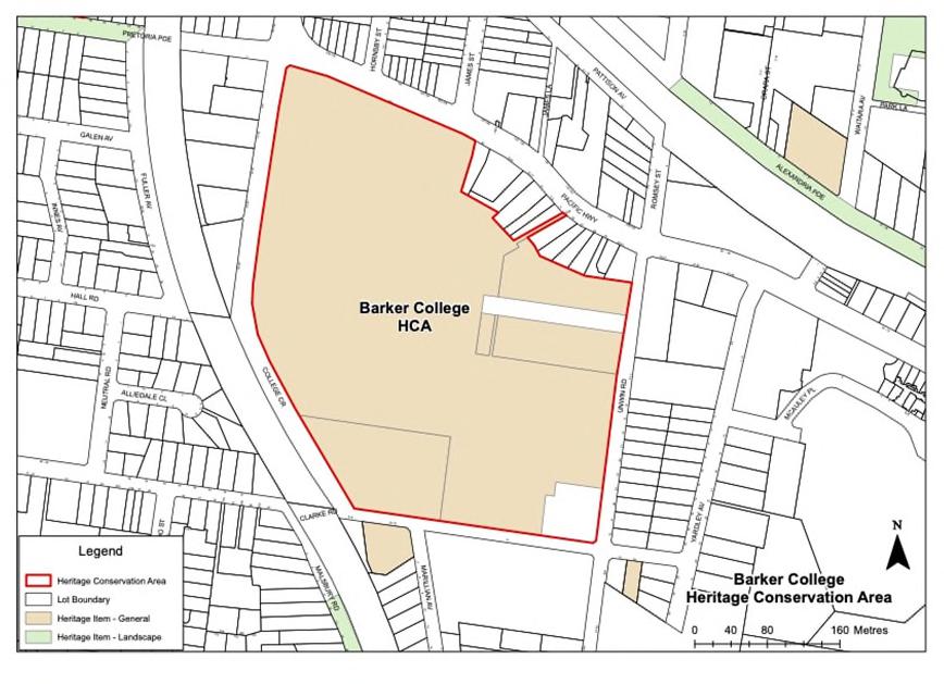
Character Statement
A group of buildings constructed between 1896 and the 1950s, consistent in low scale, traditional form, and materials,setwithin formal landscaped gardens and designed by prominent architects.
Contemporary buildings have not significantly impacted the significant buildings on site; their form and settings remain readily discernible.
Landscape features such as the formal gardens, early gates, and War Memorial Oval within the campus contribute to the setting.
Buildings along Clarke and Unwin Roads include dwellings dating from the Federation to the PostWar period, which represent residential growth between the Federation and the early Post-War period in Hornsby and Waitara.
Desired Outcome
a. Modifications to buildings within the Barker College Heritage Conservation Area are of an appropriate design that does not adversely impact the significance or character of the area
Prescriptive Measures
Table 9.11-a: Additional Prescriptive Measures – Barker College HCA Provisions
Element
Additional Prescriptive Measures
Demolition Buildings ranked as high significance should be retained. Investigate options to retain buildings ranked as moderate significance.
Subdivision The predominant building scale of twostoreys should be retained. Major views withintheschoolprecinct alongthe school streets and across the grounds from north to south and from east to west should be retained.
Materials and finishes Colours, materials, and finishes should synthesise with the general built character of the area.
These controls apply to land that is adjoining, in the visual catchment of, or across the road from a heritage item or a heritage conservation area.
Cross References to Other Sections
9.6
9.13.1 Development in the Vicinity of Heritage Items
Desired Outcomes
a. New work located in the vicinity of heritage items is sympathetic to the heritage significance of the item and its setting.
b. Development near heritage items retains and enhances public domain views to the item.
Prescriptive Measures
a. Developmentin the vicinity ofheritage items should be designed and sited so that the setting and visual curtilage of the heritage item is retained.
b. Space should be provided around the heritage item to allow for its interpretation. Original or significant landscape features that are associated with the heritage item and which contribute to its setting should be retained.
c. Developmentin the vicinity ofheritage items should complement the orientation, setback, form, and scale of the heritage item, and should not detract from the heritage significance ofthe item. The scale of new work should not be significantly larger than the scale of the heritage item.
d. Developmentin the vicinity ofheritage items should not obstruct but should enhance significant or historic public domain views to and from the heritage item.
e. Developmentin the vicinity ofheritage items should include landscape details that complement and do not detract from the setting of the heritage item.
f. The materials used for development in the vicinity of heritage items should respond to the character of the item.
Desired Outcomes
a. To ensure that new work located in the vicinity of heritage conservation areas is sympathetic to the heritage significance of the heritage conservation area and its setting.
a. Developmentin the vicinityofheritage conservation areas should respect the significant setting and visual curtilage of the area.
b. Developmentin the vicinityofheritage conservation areas should not obstruct but should enhance significant or historic public domain views to and from the area.
c. Developmentin the vicinityofheritage conservation areas is to respond to the scale, orientation, and setback of contributory buildings in the area.
d. For development in higher zones that adjoin low scale heritage conservation areas, the scale of the built form should transition down towards the heritage conservation area.
e. The form of new development in the vicinity of heritage conservation areas should visually respect the area through sympathetic interpretation.
f. The materials and details used for development in the vicinity of heritage conservation areas should complement the character of the area, including facade materials, fenestration, and fencing.
g. Development Applications for multi-unit housing adjacent to HCAs should include a construction impact report that demonstrates that the construction process will not detrimentally or indirectly adversely impact places in the HCA during construction or over time.
Notes:
The setting of a heritage item or heritage conservation area often extends beyond current property boundaries and can be influenced by historic subdivision patterns, topography, vegetation,andviewstoandfromtheheritageitemorheritage conservation area.
Itisimportanttounderstandtherelationshipofaheritageitem, or heritage conservation area, to adjoining land. Relevant factors include:
Is the site within the historic property boundaries of the heritage item?
Could development on thesite affectviews to or from the heritage item or heritage conservation area?
Coulddevelopmentonthesitechangethevisualbackdrop of the heritage item or heritage conservation area?
Is the heritage item or heritage conservation area physically separated from the development site by a road, gully or escarpment, creek or similar?
Are there any trees or remnant features on the development site that may have had an association with the heritage item?
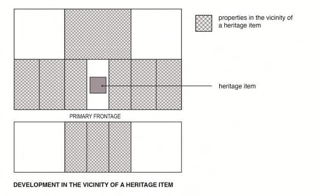
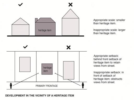
i 'Advertising', SydneyMorningHerald, 4 October 1969, p 45, State Library of NSW, Sydney Morning Herald 1955-1995.
ii ‘Advertising’, ConstructionandLocalGovernmentJournal, 2 June 1926, p 9, Trove, National Library of Australia, viewed 8 July 2022 <https://nla.gov.au/nla.news-article109640277>
iii 'Advertising', DailyTelegraph, 7 November 1903, p 7, Trove, National Library of Australia, viewed 7 July 2022 <http://nla.gov.au/nla.news-article237584102>
iv ‘Pennant Hills’, CumberlandArgusandFruitgrowersAdvocate, 21 October 1905, p 11, Trove, National Library of Australia, viewed 12 July 2022 <https://nla.gov.au/nla.news-article86175970>
v ‘Advertising’, DailyTelegraph, 17 October 1887, p 7, Trove, National Library of Australia, viewed 8 July 2022 <http://nla.gov.au/nla.news-article236767906>.