Adopted 20 October 2021
DOCUMENT CONTROL
Wimmera River Waterway Management Plan Dimboola 2019 2
Approved / Adopted By Council Date
1
Wimmera River Stakeholders Advisory Group (WRSAG) – agreed to seek Council endorsement to exhibit plan for public comment 06/02/2019 1 Council approved V1 draft for public exhibition 22/03/2019 Public comments closed 28/05/2019 2 V2 for discussion at W RSAG meeting 12/07/2019 3 V3 for discussion at WRSAG meeting 17/09/2019 4 For discussion at 17/09/19 WRSAG meeting 20/01/2020 5 Re-numbered, appendix revised, Marine Safety comments considered, preferred heights reviewed following installation of new gauges
05/02/2020 Adoption of plan to be considered by Council
25/02/2020 5 Page 5-Added information about Transport Safety Victoria’s role.
Background
Recreational water facilities contributes in excess of $1.55M in economic benefit to the businesses of the Hindmarsh Shire annually. It is estimated that the section of the Wimmera River located within Dimboola area contributes approximately $577k of economic benefit to the Hindmarsh region alone (Wimmera Southern Mallee SocioEconomic Value of Recreational Water, 2019)
The Wimmera River also has significant heritage, cultural and environmental value.
Purpose
To ensure the Wimmera River within the Dimboola locality is appropriately managed for the benefit of the environment, community, recreational users, traditional and abutting landowners.
Scope
This plan applies to the section of the Wimmera River located between Lochiel (where the river meets the A8) and Horseshoe Bend.
Objective
This plan aims to:
• ensure the Wimmera River, is enjoyed by the local community and visitors alike;
• ensure the cultural heritage of the Wimmera River is respected and protected;
• protect and enhance the environmental value and health of the river;
• identify key stakeholders;
• ensure the sustainable use of the river and environment; and
• ensure key stakeholders are consulted in any decision making with relation to the development and/or use of the river (and immediate surrounds)
Stakeholders
• Barengi Gadjin Land Council
• Wimmera Catchment Management Authority
• Hindmarsh Shire Council
• Department of Environment, Land, Water and Planning
• Parks Victoria
• Grampians Wimmera Mallee Water
• Environmental Protection Authority
• License holders of stock and domestic water rights
• Dimboola Historical Society
• Dimboola Boat & Ski Club
• Dimboola Rowing Club
• Dimboola Angling Club
• Dragon Boat Club (in recess 2019)
• Local community
• Tourists
• Wimmera River Stakeholders Advisory Group
• Transport Safety Victoria is the safety regulator for bus and maritime safety across Victoria.
Public Land & Managing Authorities with respect to the Heritage Rivers Act 1992
The Heritage Rivers Act 1992 defines managing authorities as:
"managing authority" means a person or organisation responsible for the management of public land in a heritage river area or natural catchment area, whether or not that responsibility is exercised alone or together with any other person or authority;
The Heritage Rivers Act 1992 defines public land as:
(a) unalienated land of the Crown including land permanently or temporarily reserved under section 4 of the Crown Land (Reserves) Act 1978 and State forest, within the meaning of the Forests Act 1958, and parks within the meaning of the National Parks Act 1975; or
(b) land vested in any public authority (other than a municipality or an Authority under the Water Act 1989), to the extent that the land vested in the Authority is within a sewerage district listed in Column 3 of Schedule 12 to that Act; or
(c) land vested in the Melbourne and Metropolitan Board of Works; or
(d) any other land declared to be public land by the Governor in Council under the Land Conservation Act 1970;
The Heritage Rivers Act 1992 prescribes the powers and duties of ‘managing authorities’ as -
• (1) A managing authority of a heritage river area must, in so far as it is consistent with the authority's duty to manage the area responsibly
• (a) take all reasonable steps to ensure that the significant nature conservation, recreation, scenic or cultural heritage attributes of the area are protected; and
• (b) subject to paragraph (a), take all reasonable steps to provide opportunities for other recreational activities, landscape appreciation and education within the area; and
• (c) take all reasonable steps to ensure that that part of the river which is in the area is maintained without further interference with its free flowing state except as otherwise provided in this Act.
• (2) A managing authority of a natural catchment area must, in so far as it is consistent with the authority's duty to manage the area responsibly, take all reasonable steps to ensure that the area is maintained in an essentially natural condition.
• (3) A managing authority has the power to do everything that is necessary or convenient for it to do to give effect to this Act.
Roles and Responsibilities
Barengi Gadjin Land Council
Barengi Gadjin Land Council (BGLC) is the trustee for the Native Title rights and interests of the Wotjobaluk, Jaadwa, Jadawadjali, Wergaia and Jupagulk (WJJWJ or collectively Wotjobaluk) Peoples, for the land area known as Determination Area A, which includes the Wimmera River.
In addition to holding Native Title of the river, the Wotjobaluk Peoples maintain close connection to the Wimmera River (Barringgi Gadyin) ‘the life blood’ of their Peoples. As such, the BGLC should be consulted with any proposed works or impacts on the river.
In addition, there are some legal requirements to engage with BGLC, to facilitate active involvement of Wotjobaluk peoples, described within the (Native Title) Co-Operative Management Agreement.
BGLC is also a Registered Aboriginal Party (RAP) appointed under the Aboriginal Heritage Act 2006 with decision-making responsibility for protecting Aboriginal Cultural Heritage.
Wimmera
Catchment Management Authority
Wimmera CMA is directly accountable under the Water Act 1989 for licensing works on waterways and planning referrals on floodplains. The Authority also provides advice and information on other waterway management related issues. Wimmera CMA, through strategic planning and on-ground implementation, integrates waterway management works programs and environmental water delivery into a regional waterways to maximise their effectiveness and benefit. A new gauge board was installed in 2019 to better gauge actual river heights. A Calendar of Events and preferred river heights has been prepared (see Appendix 4). The Wimmera CMA recommend that events that require a higher weir pool level, where possible, should be scheduled for winter/spring where there is a higher chance of the level being achievable.
Hindmarsh Shire Council
Hindmarsh Shire Council (HSC) is the declared waterway manager for the Wimmera River within the Hindmarsh Shire, as appointed by the Minister for Ports under the Marine Safety Act 2010 (Vic) (MSA).
Waterway managers have powers and functions under the MSA relating to the safe operation of vessels in the waters under their control.
They are also responsible for maintaining navigational aids and controlling the navigation of vessels, and this is usually accomplished through the introduction of waterway rules.
An additional function is the monitoring of the waterway and, where required, carrying out educational and compliance activities and engaging with user groups to ensure identified safety issues are addressed.
HSC also own, operate and maintain various infrastructure along the river including but not limited to:
• Boat ramps
• Fishing pontoons
• Boat pontoons
• Weirs
• Bridges
Department of Environment, Land, Water and Planning
The Department of Environment, Land, Water and Planning (DELWP) comprises Victoria’s planning, local government, environment, energy, suburban development, forests, emergency management, climate change and water functions with an aim to strengthen connections between the environment, community, industry and economy. DELWP have shared responsibilities in land management and ensuring a healthy, resilient and biodiverse environment.
Parks Victoria
Parks Victoria manage Victoria’s diverse parks system comprising 4.1 million hectares, or 18 per cent of the State. Parks Victoria manages this estate in partnership with Traditional Owners, Government and non-government organisations, park neighbours, friends’ groups and the broader community. Parks Victoria, aim to inspire the community to conserve and enjoy Victoria’s unique natural and cultural heritage. Together, care for Country and promotion of the value of our parks and waterways for the benefit of all Victorians and their visitors is achieved.
In the Wimmera, Parks Victoria manages over 300 parks and reserves totalling some 200,000 Hectares. Parks Victoria’s management responsibilities include the Wimmera River Heritage Area Park; the river corridor downstream of Polkemmet bridge through the Little Desert National Park, Lake Hindmarsh and Lake Albacutya to Wirrengren Plain in Wyperfeld National Park. Parks Victoria’s management responsibility is for the bank above the water level through to the edge of the Crown land reserve, not the water or the river bed and banks. Following a native title settlement determination in 2005 the Wimmera Heritage River Area has been co-managed by Barengi Gadgin Land Council in partnership with Parks Victoria. Parks Victoria supports the Wimmera Catchment Management Authority’s planning and delivery of environmental water in the Wimmera River, particularly where it influences the Wimmera River Heritage Area and intersects with the Little Desert NP, West Wail Flora and Fauna Reserve and Lake Hindmarsh Lake Reserve.
Grampians Wimmera Mallee Water
1. The rights for landholders to access domestic & Stock water from the Wimmera River exist under the Water Act 1989 and cannot be influenced by this plan.
2. All surface water licences located along the Dimboola Weir Pool are unregulated with no guarantee of commitment in regards to water quality, quantity or availability. They are an opportunistic licence.
3. This plan will have no impact on licences issued or right provided under the Water Act 1989.
Environmental Protection Authority
Environment Protection Authority Victoria regulates the environment and is an authority on the things that impact on our environment.
License holders of stock and domestic water rights
Stock and domestic rights are defined in Section 8 of the Water Act 1989 Local license holders have a preference of the river level to be no lower than 100.1 for as long as possible throughout the warmer and drier months of the year.
Dimboola Historical Society
Established in 1968, the Dimboola and District Historical Society aims to:
• Collect, record and preserve items of historical interest pertaining to Dimboola and District;
• assist other concurring individuals and organisations in the preservation of the community's history; and
• foster and encourage community interest and pride in their district's history.
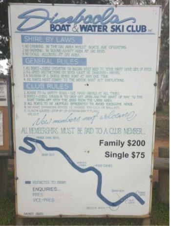
Dimboola Boat & Water Ski Club Inc
Operating from facilities at Picnic Bend, the Dimboola Boat & Ski Club, are a sporting association comprising members for boating and water skiing activities. The club is responsible for the development and maintenance of a ski friendly policy.
Membership of the club includes representatives of Dimboola in slalom and barefoot water skiing on a national level.
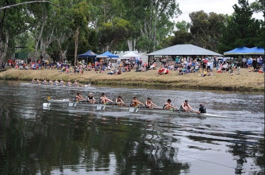
Dimboola Rowing Club
The purpose of the Dimboola Rowing Club is to promote the sport of rowing (and other forms of athletic endeavour). The club is a community driven, not for profit club which aims to facilitate access to the sport of rowing. The club officials and coaches are volunteers and aims to provide a positive sporting environment for the benefit of all members
The clubhouse is located in the Dimboola Recreation Reserve on the eastern side of the Wimmera River. There is a boat landing area directly in front of the club house.
Training Area
The general training area extends from the Wimmera Street Bridge to Picnic Bend (just short of the ski area) and on limited occasions from the Wimmera Street Bridge to Horseshoe Bend. (Rowing camps/long distance training/closure of selected river areas for other river user events).
Competition course areas
The club has two designated competition areas. The first area is where the annual club regatta is held from the Lloyd Street Boat ramp to the Wimmera Street Bridge which includes the start marshalling area and landing areas The second area is the
annual Head of the Wimmera regatta which is held from Rocky Bend to the Wimmera Street Bridge over 6.2 km in distance.
Both these competition courses require a large number of volunteer labour hours to set up and dismantle prior to and after each event.
Dimboola Angling Club
The angling season is year round with the Dimboola Angling Club hosting a number of competitions throughout the year in including the Dimboola Fishing Classic held mid to late November.
Local community
All members of the community have rights to access and enjoy the Wimmera River.
Tourists
Tourism plays a significant role in the economic sustainability and prosperity of the Wimmera Region including the township of Dimboola and beyond. The Wimmera Southern Mallee Socio-Economic Value of Recreational Water report commissioned by the Wimmera Catchment Authority, estimates that the Wimmera River within the Dimboola area attracts approximately 2,800 overnight visitors, 6,400 active day users and approximately 13,600 passive day users per annum, generating in excess of $330,000 in local expenditure
This plan recognises the importance of tourism to the Wimmera Region and aims to provide for active and passive recreational pursuits for various groups.
Wimmera River Stakeholders Advisory Group
The Wimmera River Advisory Group was established in 2017 and comprises a membership of:
• Councillor of Hindmarsh Shire Council
• Wimmera Catchment Management Authority
• Dimboola Boat and Water Ski Club Inc.
• Dimboola Rowing Club
• Landowners who hold Stock and Domestic Water licenses
• Dimboola Angling Club
• Dimboola & District Historical Society
• Hindmarsh Landcare
Guests from the following organisations are invited to meetings as required:
• Barengi Gadjin Land Council
• Parks Victoria
• Transport Safety Victoria
• Environment Protection Authority
Transport Safety Victoria
Transport Safety Victoria (TSV) is the independent regulator for bus, rail and maritime safety across Victoria. Maritime Safety Victoria (MSV) is a branch of TSV and is responsible for administering maritime legislation and providing knowledge, education, support and direction to vessel operators and port and waterway managers.
The Minister for Ports has appointed Hindmarsh Shire as the waterway manager for the Wimmera River within the Shire of Hindmarsh. MSV assists waterway managers to carry out their functions and provides advice and assistance in addressing waterway safety issues, making waterway rules and managing on water events.
Definition of Vessels
ISO 8666:2016 establishes definitions of main dimensions and related data and of mass specifications and loading conditions. It applies to small craft having a length of the hull (LH) of up to 24 m.
In summary, this is the complete length of the boat, but excludes outboard motors and any other type of equipment that can be detached without the use of tools.
Permitted Activities
Fishing
Fishing is permitted from the river banks and from boats.
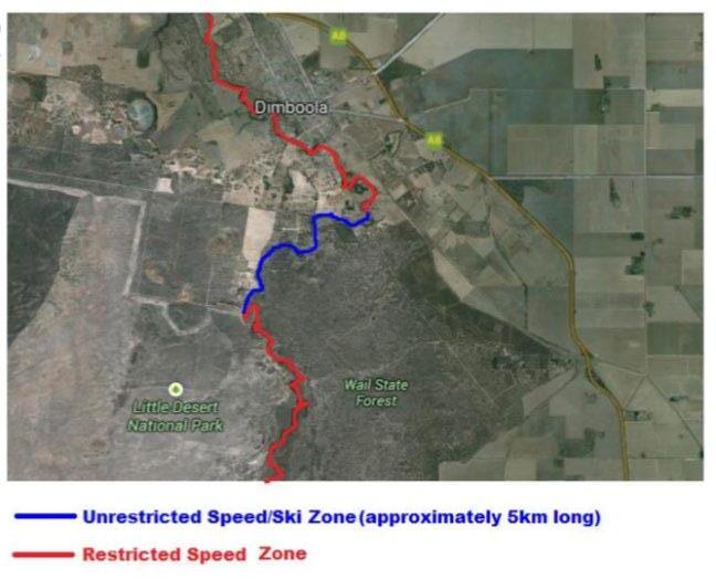
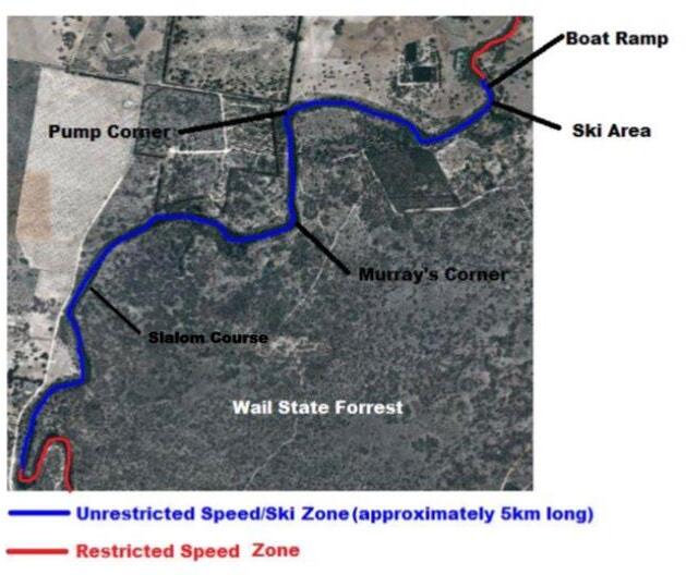
Skiing
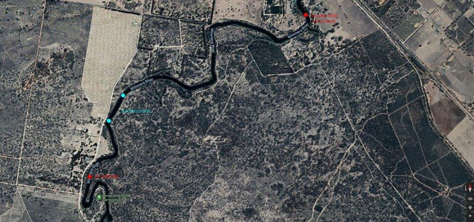
Skiing is permitted along approximately 5km of the river as marked below in the area occupied by the Dimboola Boat and Ski Club, where there are no speed restrictions and vessels are permitted to travel at speeds exceeding 5 knots within 50 metres of the waters’ edge (all vessels must not exceed 5 knots within 50 metres of another vessel or a bather). Boats are restricted to a speed limit of 5 knots per hour outside of the designated ski zone illustrated in blue below.
There are no restrictions on the Dimboola section of the river on the type of vessel that can use the waterway whether powered or unpowered.
Skiing is permitted in restricted areas on a case by case basis for special events.
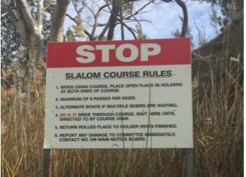
The Dimboola Boat & Ski Club is responsible for developing and maintaining a ski friendly policy incorporating permitted times of skiing, permitted boat types, boat ramp operations (etiquette), boat etiquette, hand signalling, flag procures for slalom course, river inspections for obstacles and hazards, inspections of devices such as buoys and markers.
Note: While the Dimboola Boat & Ski Club may be able to exercise a ‘ski friendly’ policy, there are no official and legally enforceable rules that establish times for skiing, boat types, hand signalling and flag procedures for the slalom course.
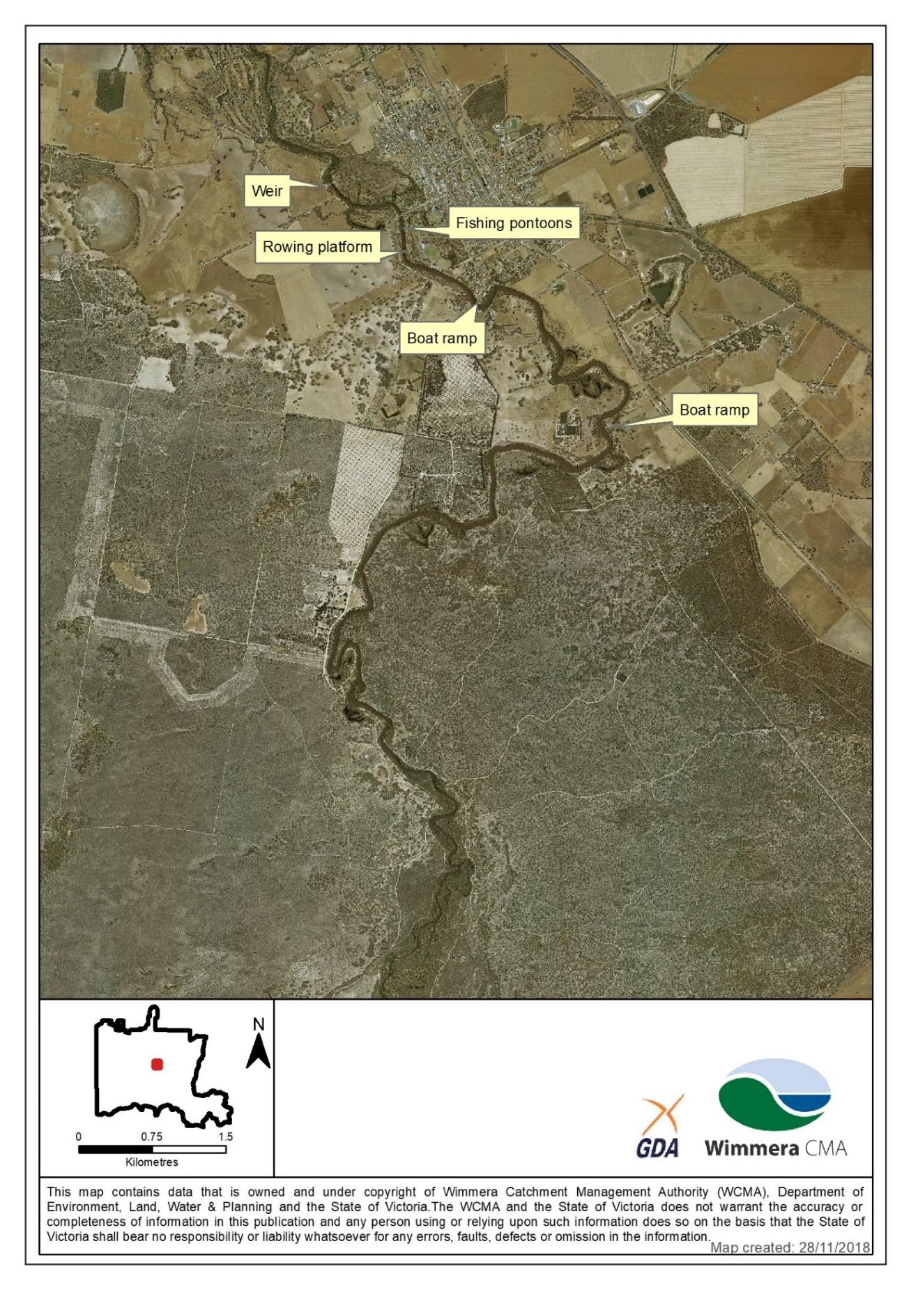
The image below illustrates the location of the boat ramp, Dimboola Boat and Ski Club facility and slalom course. (See Appendix 2 also).
Restricted Activities
Duck Hunting
The Wildlife (Game) Regulations 2012 prescribe the annual duck hunting season opening on the third Saturday in March and closing on the second Monday in June, each year. However, under the Wildlife Act 1975, the Minister can vary the hunting arrangements.
Duck hunting is not be permitted within the designated ski zones, and in areas where events are being held.
The Game Management Authority, Parks Victoria and the Department of Environment, Land, Water and Planning identify areas where duck hunting is prohibited and also enforce relevant hunting and firearms laws across Victoria.
Hindmarsh Shire Council notes that there may be exemptions to duck hunting regulations permitted to Native Title holders (under the Native Title Act) at the discretion of the relevant Minister.
River Height Management
The height of the river (within the scope area), is managed by a weir. The weir is owned and operated by Hindmarsh Shire Council, with height adjustments being made in consultation with a number of stakeholders for various purposes.
Refilling of the weir pool should only be undertaken using unregulated inflows and runoff. Environmental water releases should not be used without prior consultation and approval from Wimmera CMA.
When refilling the weir pool a portion of the inflows should be allowed to pass downstream of the weir to ensure the health of the overall river.
Flood Mitigation
The Dimboola Weir plays a key role in reducing flood risks for the township of Dimboola. As such, any requests to adjust the height of the weir from the State Emergency Services and/or other responsibility authorities for the purpose of flood mitigation will be adhered to. The Hindmarsh Shire Council Municipal Flood Response Plan provides guidance weir operations for various flow events.
Environmental River Height Management
The Wimmera Catchment Management Authority (WCMA) will advise of preferred heights for environmental purposes from time to time. The heights as recommended by the WCMA will take priority over all other height preferences, apart from floodplain management. A new depth gauge board was installed in 2019 to assist with managing river heights based on the Australian Height Datum (AHD). Regulated environmental water releases will be also passed through the Dimboola weir pool on the advice from Wimmera CMA.
Flows reaching the Dimboola Weir Pool can be from a several sources:
Unregulated flows that occur due to high rainfall, typically during winter/spring leading to large volumes of runoff from tributaries entering the Wimmera River.
Regulated environmental flows which are flows released from water storages (Taylor’s Lake, Lake Lonsdale, Lake Wartook) to maintain and improve the environmental conditions of the Wimmera River and other waterways.
Passing flows which are a proportion of natural flows that reach Lake Lonsdale or Huddleston’s Weir and are allowed to keep flowing rather than be kept in a storage for allocation.
Given unregulated flows happen during wet conditions, their passage through weir pools does not require management beyond considerations around infrastructure and flood management. Information from the river flow gauging network is critical for understanding the magnitude of flows and what (if any) operational changes to the Dimboola Weir are required.
http://www.bom.gov.au/cgi-bin/wrap_fwo.pl?IDV60148.html
Regulated environmental and passing flows may require more direct management given they have been explicitly provided to the Wimmera River for environmental
outcomes. This is particularly important during drought conditions. Management of the weir might involve setting the weir gates at the water level during periods of no flow so when environmental flows reach the weir pool, they can continue downstream without raising the weir pool water level. On other occasions, filling the weir pool with environmental will be desirable given its value as a refuge pool for fish etc.
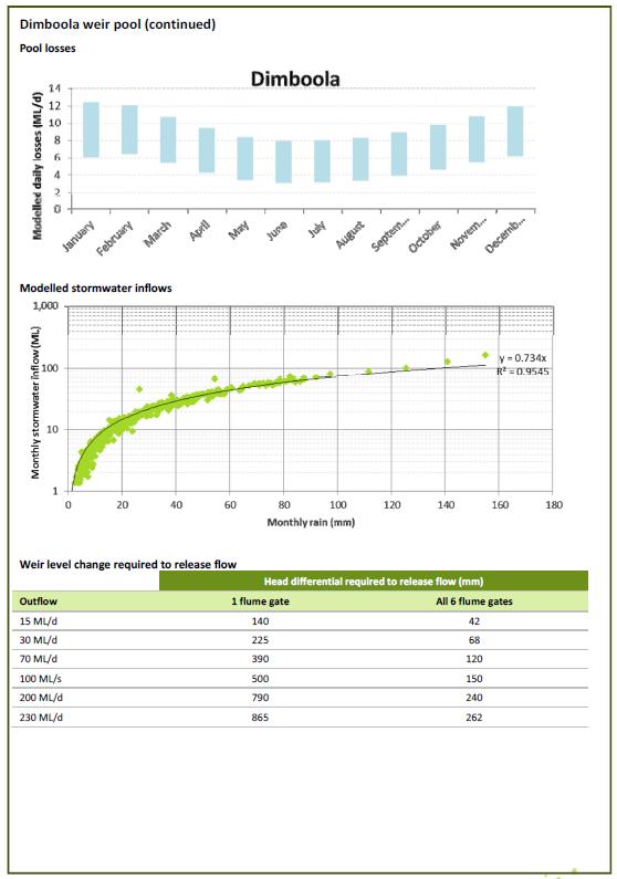
Given the objective to vary water levels over the course of a year to reduce erosion risks and protect its values, releasing water from the weir pool to achieve environmental objectives (e.g. creating a temporary ‘pulse’ of water downstream to disperse saline water and inundate higher parts of the river bank) could warrant a subsequent ‘repayment’ of environmental water later on in the year. Losses from seepage and evaporation and gains from stormwater contributions also need to be considered.
Flexibility in water level and environmental water management is critical given the range of scenarios that take place. This requires regular communication between Wimmera CMA and Hindmarsh Shire staff to ensure a shared understanding of planned flows and objectives, weir pool conditions and weir management considerations.
Management of environmental flows in and through Wimmera Weir Pools (Alluvium Consulting, 2014) is a very comprehensive report developed in consultation with stakeholders and provided recommendations for management of environment water in and through weir pools. These recommendations inform actions by Wimmera CMA and Hindmarsh Shire to pass flows through the weir pool.
The report also considered other objectives such as minimising algal blooms, maintaining weir pool ecology (native fish and vegetation), enhancing social amenity and limiting operational complexity and weir pool bank erosion.
Key conclusions are as follows:
It recommended that weir pool ecology is maintained by:
• Allowing water levels to fluctuate seasonally;
• Limiting water depth variations to approx. 50 cm over 6 months;
• Controlling rates of inundation and drawdown to 1-2cm per day to prevent slumping; and
• Analysis of weir pool characteristics (depth, volume etc.) indicates that most of the time flow is insufficient (<400 ML/d) to provide the necessary turbulence to prevent blue green algal blooms.
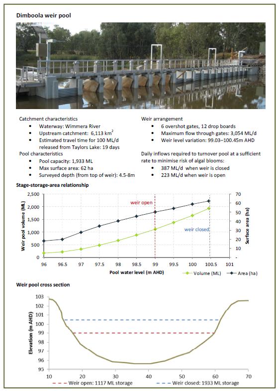
Useful facts and figures on the Dimboola Weir Pool from the Alluvium (2014) report follow:
Ski Season – Variable
The use of the river is “self-regulating” with regard to water skiing. With the exception of a small number of enthusiasts, the ski season is usually determined by ambient and water temperature. Typically, after February the number of users decrease by half as
the month before and so on. At the end of April each year, the use of the waterway by skiers is reduced to very low numbers.
For the benefit of the river and banks, the Dimboola Boat & Water Ski Club prefer to see a rise and fall of between 99.8 to 100.3 throughout the ski season. A height of 100.3 is preferred for competitions / titles, as this provides a ‘wide’ river.
Angling Season – Year round
The angling season for the Wimmera River is year round with the Dimboola Angling Club hosting a number of competitions throughout the year.
During mid-late November each year the Dimboola Fishing Classic is held raising funds for Allambi Elderly Peoples Home in Dimboola. The Club prefers a height of 100.3 for the Fishing Classic and a gradual rise and fall at others times to create natural habitat for fish to breed.
Rowing Regatta – Early to mid-November annually
The Dimboola Rowing Club host the annual Dimboola Rowing Regatta. The preferred height for this event is 100.3 with a gradual drop to 99.8 over the summer period. Levels below 99.8 may create risks to the floating pontoon.
The Dimboola Rowing club currently conducts two rowing Regatta’s. The first being the annual club regatta conducted on the Saturday and the second being the Head of the Wimmera on the Sunday.
The Dimboola Rowing Club conducts both regattas during the month of November to accommodate volunteers from agricultural pursuits, take advantage of the seasonal river height and to avoid potential event cancellation due to strict heat policies enforced by Rowing Victoria.
License holders of stock and domestic water rights
Local license holders advise a preference of the river level to be no lower than 100.1 for as long as possible throughout the warmer and drier months of the year.
Other
While every attempt will be made to meet the preferred river heights in this Plan, the weir pool level will be adjusted by Hindmarsh Shire Council, in consultation where appropriate, with the Wimmera CMA to ensure the long term health of the river.
The preferred river heights listed in Appendix 4 of this Plan may not always be possible as they are dependent on river flows and rainfall. When the desired heights are not achievable with unregulated inflows, Hindmarh Shire Council will consult with Wimmera CMA and relevant stakeholders to look at options to raise the weir pool.
Requests to adjust the weir pool height for other purposes such as the passage of environmental flows, specific events or rehabilitation programs will be considered in consultation with the relevant stakeholders.
Access Points
There are a number of access points along the river for a number of activities.
The appropriate land manager under their land management responsibilities can control access to the waterway.
Gazetted Waterway Rules
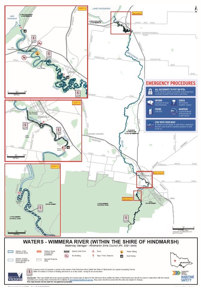
Schedule 68 of the Vessel Operating and Zoning Rules (VOZR) apply to the waters of the Wimmera River within the Shire of Hindmarsh.
All waterway rules are made by the Director, Transport Safety, under section 184 of the Marine Safety Act 2010 (Vic), and can be made at the request of port management bodies, local port managers and waterway managers for waters under their control.
The purposes for which these rules can be made are: (i) regulating or prohibiting the operation of any or class of vessels; (ii) regulating the use of waters by bathers and others, where that use affects any boating activity; and (iii) regulating the charts, appliances and other equipment that must be carried on vessels.
Gazetted waterway rules are the only standing laws. Relevant rules that apply to the Wimmera River within the Shire of Hindmarsh include Schedule 68 of the Vessel Operating and Zoning Rules, which are approved by Maritime Safety Victoria under Part 5.1 of the Marine Safety Act 2010 (Vic) and preceding legislation.
Rules under Schedule 68 are as below:
68.1. Excluded speed limit for the purposes of Clause 3(a).
Those waters of the Wimmera River within the Shire of Hindmarsh which are not otherwise specified as a five (5) knot speed restriction zone are not subject to the requirements of Clause 3(a) of this notice.
68.2. Five (5) knot speed restriction zones for the purposes of Clause 7.
Those waters of the Wimmera River that are -
(a) between -
(i) a line between two skiing signs on opposite banks of the river approximately 140 metres downstream of the old road bridge at Jeparit; and
(ii) a line between two chequered marker signs on opposite banks of the river on the southern prolongation of the eastern boundary of Crown Allotment 7, Parish of Jeparit;
(b) between –
(i) the weir wall at Jeparit, and
(ii) downstream to a line between two chequered marker signs on opposite banks of the river at the old railway bridge at Jeparit;
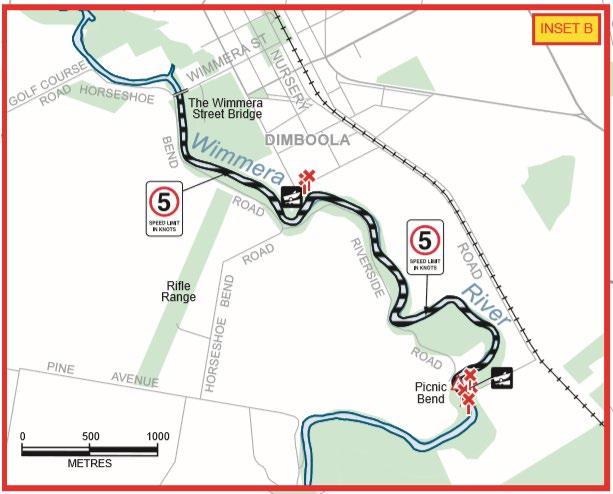
(c) between the Wimmera Street Bridge, Dimboola, and a line between two chequered marker signs on opposite banks of the river on the south-western
prolongation of the north-western boundary of Crown Allotment 71, Parish of Dimboola;
(d) between two chequered marker signs on opposite banks of the river of the easterly prolongation of the northern boundary of Crown Allotment 1, Parish of Pomponderoo, and two chequered marker signs on opposite banks of the river on the easterly prolongation of the southern boundary of Crown Allotment 1, Parish of Pomponderoo;
are subject to a speed restriction of five (5) knots.
68.3. Areas where vessels are prohibited for the purposes of Clause 9
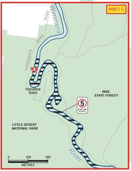
Those waters of the Wimmera River from the weir wall at Jeparit and extending upstream approximately 140 metres to two “Vessels prohibited” signs on opposite banks of the river are, prohibited to vessels.
68.4. Exclusive use and Special Purpose Area for the purpose of Clause 13
Those waters of the Wimmera River between:
(a) a line between two skiing signs on opposite banks of the river approximately 140 metres downstream of the old road bridge at Jeparit; and
(b) a line marked by red buoys between two “Vessels prohibited” signs on opposite banks of the river approximately 140 metres upstream of the weir wall at Jeparit;
are set aside for the exclusive use of vessels engaged in water skiing.
Wimmera River Stakeholders Advisory Group (WRSAG) rules
Swimming
Swimming is prohibited in gazetted ski areas during Water Skiing hours.
Boating Rules
Unless otherwise permitted by Hindmarsh Shire Council, boating hours are limited to 8.30am to 8.00pm for the months November through to April and 8.30am to 5.30pm for the months September through to October.
All boat drivers must be licensed and comply with the Marine Act including being equipped with relevant safety equipment.
All inboard power boats must be fitted with approved silencers with full flow cooling water running through them.
All boats towing skiers must have an observer 12 years of age or older.
Boats must keep to the Right Hand side of the river.
Boats must not follow in the wake of a boat towing a skier.
Hand signals must be given to indicate a fallen skier in the water, and must be acknowledged by any approaching boats to indicate that they are aware of the fallen skier.
Releasing of trick skiers is to be done only by the observer (Not the driver).
Boats must be removed from the river for refuelling.
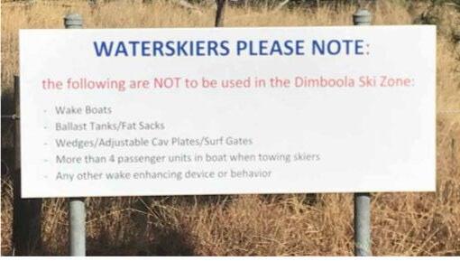
No inflatable objects are to be towed.
The use of artificial wedges and fat sacks to create oversizes wakes is prohibited.
Wake enhanced boats are prohibited.
Environmental Management
Monitoring of River Health
The Wimmera CMA undertake basic water quality monitoring across the catchment including at sites at picnic bend and at the Dimboola weir on a monthly basis. The program monitors turbidity, oxygen levels, pH etc.
Hindmarsh Shire Council can also perform water quality tests if requested
Revegetation Programs
Wimmera CMA will continue to assist the community in implementing revegetation programs that improve waterway health and are in line with the Wimmera Waterway Strategy.
Noise
Refer EPA guidelines – see link below.
https://ref.epa.vic.gov.au/business-and-industry/guidelines/noise-guidance
Note: any activity that impacts the bed of the River could trigger a Future Act, under the Native Title Act, and will require engagement with BGLC.
Enforcement
There a number of authorities who have enforcement powers.
Waterway Managers can have Transport Safety Officers appointed by TSV under the Transport (Safety Schemes Compliance and Enforcement) Act 2014 to enforce the Marine Safety Act 2010 and Marine Safety Regulation 2012 on their waterways (waterway rules, licencing, registration, safety equipment etc.).
While Maritime Safety Victoria (MSV) is the primary agency responsible for enforcing marine safety legislation in Victoria, Transport Safety Officers are appointed to enforce this legislation and assist MSV in its functions in order to promote responsible and safe boating behaviour.
Victoria Police and Fisheries Victoria Officers can also enforce the requirements of the Marine Safety Act 2010 and Marine Safety Regulations 2012.
The Game Management Authority in conjunction with the Department of Environment, Land, Water and Planning, Parks Victoria and Victoria Police enforce relevant hunting and firearms laws across Victoria.
Fisheries Victoria’s responsibilities include aquaculture, recreational and commercial fisheries management and licensing and have enforcement powers with regard to illegal fishing activity.
Parks Victoria has authority under state legislation to enforce park regulations under numerous acts including the National Parks Act 1975, the Crown Land Reserves Act 1978, the Wildlife Act 1975, the Forests Act 1958 and the Country Fire Authority Act 1958.
BGLC & Aboriginal Victoria (Dept Premier & Cabinet) enforce (Aboriginal) heritage management and protection under the Aboriginal Heritage Act 2006.
Related Legislation
• Marine Safety Act, 2010
• Marine Safety Regulations, 2012
• Transport (Safety Schemes Compliance and Enforcement) Act 2014
• Environmental Protection Act, 1970
• Hindmarsh Municipal Local Law no.2
• Heritage Rivers Act, 1992
• Wildlife (Game) Regulations, 2012
• Native Title Act 1993 (Fed)
• Traditional Owner Settlement Act 2010
• Water Act 1989
Related Documents
Wimmera Waterway Strategy, Wimmera Catchment Management Authority
Growing What is Good Country Plan, Barengi Gadjin Land Council
Hindmarsh Shire Council Municipal Flood Response Plan
References
Wimmera Southern Mallee Socio-Economic Value of Recreational Water
www.delwp.vic.gov.au
www.transportsafety.vic.gov.au
www.hindmarsh.vic.gov.au