Hindmarsh Shire Council

Nhill Aerodrome Master Plan Update 2019
Hindmarsh Shire Council Report
Janette Fritsch
Acting Director Infrastructure Services PO Box 250 92 Nelson Street Nhill VIC 3418
To70 Aviation Australia Pty Ltd
Suite 19, 70 Racecourse Rd North Melbourne VIC 3051
Email: info@to70.au
Authors: Rob Morris, Leonard Aguero
DOCUMENT CONTROL
NhillAerodromeMasterPlan Version Number
Responsible Officer
Glossary of Terms
Airport Master Plan
A strategic document produced by the airport owner / operator, setting the direction for development of the airport over a period of time, usually between 10 – 20 years
Airport Reporting Officer (ARO) Person working for, or on behalf of, the airport operator who ensures that the airfield meets the standards required by regulators (CASA, Airservices, EPA, etc)
GNSS Global Navigation Satellite System, the standard generic term for satellite-based navigation systems such as GPS & GLONASS
IFR Instrument Flight Rules, a flight classification where aircraft are flown and navigated using avionic instruments instead of visual reference
MOS 139
NDB
Non-Precision Approach
NOTAM
Manual of Standards – 139 Aerodromes, produced by CASA, is the set of standards that the aerodrome must meet to comply with the airfield classification
Non-Directional Beacon, radio-based navigation aid (now decommissioned at Nhill)
A runway approach to Nhill Aerodrome using flight instruments when the aerodrome cannot be seen above a certain altitude. Nhill Aerodrome does not have the facilities to support Precision Approaches which allow for worse conditions.
Notice To Airmen – Messaging format used to communicate information about flight conditions (i.e. temporary closures, obstacles, bird flocks, etc)
OLS Obstacle Limitation Surface – virtual surface around an aerodrome to provide safe approaches and visibility
Registered Aerodrome
RNAV
Aerodrome classification provided by CASA
aRea Navigation – method of instrument-based navigation where the aircraft can fly within a network of navigation aids rather than flying from beacon to beacon (e.g. GNSS)
RPT Regular Public Transport, aviation industry terminology for a scheduled passenger service
Safeguarding Term describing the rules and processes in place to ensure that airports function safely and effectively in conjunction with surrounding communities, covering topics such as aircraft noise, building encroachment and windshear
VFR Visual Flight Rules, a flight classification where aircraft are flown and navigated by visual reference
VOR
VHF Omnidirectional Range, radio based navigational aid (now decommissioned at Nhill)
Introduction
Hindmarsh Shire Council (Council) are the owner and operator of Nhill Aerodrome and in August 2018 sought to review and update the Nhill Aerodrome Master Plan to outline the strategic direction for the aerodrome in the medium to long term.
Council and the Nhill Aviation Heritage Centre (NAHC) have worked together to deliver a wonderful facility at the site, capturing the historical significance of Nhill Aerodrome as an important part of Australia’s rich aviation past; featuring aircraft and other memorabilia. In 2019, Nhill Aerodrome will be celebrating its Centenary with a fly-in and Airshow.
The vision for Nhill Aerodrome is to:
Provide small regional aerodrome facilities for local residents and emergency services while continuing to preserve the historical authenticity and character of the locale to attract visitors to a unique Australian aviation heritage site.
The advantages and opportunities for Nhill Aerodrome are:
• Support from Council and the local community and minimal objection to the continuing operation of the aerodrome.
• The heritage centre and building assets at the site, such as the original buildings, aeradio station and decommissioned navigational equipment, all of which would be on interest to enthusiasts.
• Modern facilities for air ambulance and fire-fighting services.
• An area of the aerodrome has been set aside for recreational vehicles and camping.
Key recommendations of the Master Plan are:
Leverage the historical significance of the aerodrome, liaise with Heritage Victoria and Visitvictoria to increase the profile of the aerodrome. This could be especially relevant for the 2019 Armistice Centenary commemoration.
Ensure that the Aerodrome Manual is updated to comply with upcoming changes to CASA MOS 139, in order to continue as a Registered Aerodrome.
Prepare a development overlay based on the footprint of airport OLS to ensure that developments with potential airspace impacts are identified.
Establish separate precincts at the aerodrome for different activities, the Master Plan update outlines concept plans for an Emergency Services Hub (ESH), Proposed Hangar Area (PHA) for private and commercial interests and the Ahrens Hangar Expansion (AHE) and Heritage Area (HA) for continued restoration of the historical site.
Nhill Aerodrome is located 2.5km northwest of the township of Nhill, close to the Western Highway and is owned and operated by the Hindmarsh Shire (Council). The aerodrome was the official aerodrome in country Victoria established in 1923, with the current aerodrome established in 1937-1938 with the building of an Aeradio station for navigation and a refuelling station for flights between Melbourne and Adelaide.
The aerodrome has two runways, one sealed (09/27 1,000m) and one grass (18/36 1,102m), providing for emergency services, as well as receiving visiting businesspeople, politicians, aviation tourists and private aviators. Nhill Aerodrome serves the town of Nhill, as well as the local Wimmera and Mallee regions.
1.1 Purpose and Objectives of the Master Plan
The Nhill Aerodrome Master Plan Update 2018 is the key strategic document which provides a basis for all activities and decision of the Council in relation to the development of the aerodrome. It communicates Council’s long-term future planning intentions and describes future development opportunities. The Master Plan also needs to reflect consultation with the local community and airport users, as well as environmental and regulatory obligations.
A previous Master Plan was developed in 2012 by Kevin Joy Architects and has not been updated since its initial publication. The Nhill Aerodrome Master Plan Update 2018 aims to revise the previous Master Plan, encompassing a 10-year planning horizon, covering existing aerodrome facilities and future planned aerodrome facilities. The Council has specified for the Master Plan to reflect the current usage of the Aerodrome and provide guidance by highlighting objectives such as promoting the aerodrome in its relationship to the region, provide for aviation based recreational pursuits, explore tourism opportunities and encourage light aviation based commercial activity.
Through reference to the previous Master Plan, feedback from Council and in consultation with key stakeholders a strategic vision has been outlined to provide broad guidance and direction for the future development of Nhill Aerodrome.
The strategic plan for Nhill Aerodrome has been shaped by three drivers:
- Preserving the heritage value of the Aerodrome and enhancing the site as a visitor destination,
- Providing service for general aviation in the region, such as training and support for private and recreational pilots,
- Supporting emergency services in the region.
The Nhill Master Plan 2018 has relied upon internal Council resources, external expertise, as well as extensive stakeholder consultations. The final goal to develop a shared vision and future direction for the aerodrome was the driver for this approach.
A review of the previous Master Plan, key strategic documents and studies was completed to understand the background and current situation of the aerodrome. The project team used the Regional Airport Master Planning Guideline developed by the Australian Airports Association’s (AAA) as the framework for the Preparation of the Nhill Master Plan 2018 in a six-stage process:
Stage 1 –Project Inception
Stage 2 –Background Review & Stakeholder Consultation
Stage 3 –Future Direction
Stage 4 –Strategy Development Document
Stage 5 –Draft Master Plan
Stage 6 –Final Master Plan
Figure 2- Master Plan Development Stages
The Master Plan is a comprehensive document that provides a framework for future planning of Nhill Aerodrome and is structured into the following sections:
Table 1 - Master Plan structure and contents
Section
Executive Summary
1 Overview
2 Master Plan context
3 Current situation
4 Critical airport planning parameters
5 Aerodrome Land Use and Development Plan
6 Implementation plan
Description
• Brief description
• Definition of objective and purpose of Master Plan
• Methodology
• Background of the aerodrome
• Historical and social economic context of the aerodrome
• Regulatory and policy context
• Review of previous/current Master Plan
• Description of current airport site, facilities, activities
• Estimation of future traffic growth
• Description of future aerodrome requirements and considerations
• Key land use precincts
• Definition of a 10-year land use plan
• Overview of the 10-year aerodrome development including facilities, ground transport, environmental, heritage and safeguarding plans
• Project implementation roadmap with trigger points
This section sets out the context for the Master Plan including the regulatory and policy environment that applies to the aerodrome.
Nhill is a regional town in western Victoria, with 2,184 residents (ABS 2016 Census) and since 2011 has experienced an aging population, which is a common trend for many regional areas. Nhill has garnered media interest due to its program to settle and integrate Karen migrants from Burma into the local community, which increased population numbers and benefitted the local economy. The major industry in the Shire is agriculture (livestock and cropping) and most of the workforce are employed in this industry. Other significant employers in the township of Nhill are the hospital and Council
Nhill Aerodrome is a regional aerodrome serving the town of Nhill and surrounding area, located in Hindmarsh Shire and approximately halfway between Melbourne and Adelaide on the Western Highway. The aerodrome is currently owned by Hindmarsh Shire Council, with the Nhill Aviation Heritage Centre and Nhill Aeroclub as tenants.
The aerodrome’s history can be traced back to 1919 when a de Havilland DH6 landed at Nhill Racecourse in 1919 and the building of an Aeradio station in 1938. An RAAF training base was established in 1941 and operated during the Second World War until 1946, training young pilots and predominantly using the Avro Anson. After the war, the aerodrome continued operations for pilot training, charter flights, air ambulance visits and as a refuelling point for light aircraft on Melbourne-Adelaide flights, and more recently as a destination for private aviators and aviation tourism with the establishment of the NAHC which has begun the restoration of an Avro Anson for display.
Horsham and Warracknabeal airports (60 and 69 kilometres away) are the closest airports to Nhill, with Horsham being the closest regional airport as an airport with RPT capabilities.
Nhill Aerodrome provides support to the tourism industry of Nhill, mainly through the NAHC which supports and runs occasional events such as the Nhill Airshow, as well as running a museum displaying the history of aviation in Nhill and the display historical aircraft such as a partially restored Avro Anson aeroplane and a fully restored and operational Tiger Moth aeroplane.
Other than the tourism benefits that the aerodrome brings, it provides an important role in accommodating and supporting the following activities and services:
• Emergency services (includes use by CFA Aviation Units)
• Charter services
• Recreational aviation businesses
• Private recreational aviation and aircraft storage
• Pilot training (provided by the Nhill Aero Club)
As a remote airport, Nhill Aerodrome provides an important role to providing and sustaining the regional economy and various social benefits such as a link to regional emergency services, commercial and recreational facilities and facilitating social connections.
2.1.1 Civil Aviation Safety Authority (CASA)
CASA is the authority responsible for the implementation and enforcement of safety regulations for civil aviation operations in Australia. Their authority is derived under the Civil Aviation Act 1988 and promulgated through Civil Aviation Safety Regulations 1988 (CASRs). CASA has powers to protect operational airspace or to curtail aircraft operations if they believe safety is compromised.
CASR Part 139 prescribes the requirements for aerodromes used in air transport operations. The Manual of Standards (MOS) Part 139 Aerodromes is made pursuant to CASR Part 139 and sets out the detailed standards and operating procedures for aerodromes used in air transport. The manual provides the rules, mandatory standards, procedures, and guidance information relating to the planning, design, and operation of Airports.
CASA conducts periodic inspections (surveillances) to ensure airport and aircraft operators meet their responsibilities under MOS 139. Aspects of aerodrome safety relevant to Nhill include;
• Aerodrome operation and maintenance
• Protection and use of runways, taxiways, and other movement areas
• Protection of airfield airspace
• Hazard and wildlife control
• Administration
The MOS 139 is currently under review to ensure that it aligns with current regulatory policy (including ICAO), industry developments and technology changes
Nhill Aerodrome is a registered aerodrome (R026) meaning it must meet the following requirements:
• A trained Aerodrome Reporting Officer (ARO) employed to carry out aerodrome safety functions
• Published aerodrome details and NOTAMS in the En-Route Supplement Australia (ERSA)
• OLS obstacle monitoring.
• If RPT or charter operations with more than 9 passenger seats are introduced an Aerodrome Safety Inspection is required.
2.1.2 Airservices Australia (Airservices)
Airservices has responsibility for the management of airspace and air traffic, and to provide Australia’s network of aviation users with facilities for aircraft navigation, communication and surveillance.
Local governments are encouraged to seek advice from Airservices on any development that has the potential to impact an aviation facility’s sensitive areas such as landing and navigational areas.
Airservices are also responsible for the operations and maintenance of navigational aids at airports.
2.1.3 Environment Protection and Biodiversity Conservation Act 1999 (Commonwealth) (EBPC Act)
The EBPC Act provides a legal framework to protect and manage nationally and internationally significant flora, fauna ecological communities and heritage places.
2.1.4
The aerodrome is subject to planning policies and controls under the Planning and Environment Act 1987, which sets out broad objectives for planning in Victoria, and key planning procedures and systems. The Act establishes the following:
• The planning scheme system, which sets out how land may be used and developed
• Victoria Planning Provisions that set out the template for the construction and layout of planning schemes
• The procedures for preparing and amending the Victoria Planning Provisions and planning schemes
• The procedures for settling disputes, enforcing compliance with planning schemes and, and other administrative procedures
2.1.5
The Environmental Protection Act aims to protect the environment in the state of Victoria through a legal framework. It applies to noise emissions, air, water and land in Victoria, the sea along the Victorian coast and the discharge of waste to the Murray River. The Act covers the following environmental issues:
• Pollution of air, land and water
• Waste
• Litter
• Noise
• Motor vehicles
• Hazardous chemicals
• Environmental audits
2.1.6
As a Council owned asset, the aerodrome is subject to the requirements of the Local Government Act 1989. This applies to the sale, lease, transfer exchange and use of land. Council must operate in accordance with the Local Government Act.
2.2 Policy context
This section details the relevant policies that influences the future use and development of Nhill Aerodrome. It is important to ensure that the Master Plan is consistent with the existing planning policies, strategic objectives and guidelines.
2.2.1 National Airports Safeguarding Framework (NASF)
The NASF is a national land use planning framework that aims to:
• Improve community amenity by minimising aircraft noise-sensitive developments near airports; and
• Improve safety outcomes by ensuring recognition of aviation safety requirements in land use planning decisions.
NASF was developed by the National Airports Safeguarding Advisory Group (NASAG), comprising Commonwealth, State and Territory Government planning and transport officials, the Australian Government Department of Defence, the Civil Aviation Safety Authority, Airservices Australia, and the Australian Local Government Association.
NASF was convened by Commonwealth, State and Territory Ministers at the Standing Council on Transport and Infrastructure (SCOTI) meeting on 18 May 2012. The agreement represents a collective commitment from Governments to ensure that an appropriate balance is maintained between the social, economic and environmental needs of the community and the effective use of airport sites. The Framework applies at all airports in Australia and affects planning and development around airports, including development activity that might penetrate operational airspace and/or affect navigational procedures for aircraft. Pursuant to the SCOTI agreement, it is the responsibility of each jurisdiction to implement the Framework into their respective planning systems.
NASF is comprised of a set of seven principles and seven guidelines. The NASF principles are:
• Principle 1: The safety, efficiency and operational integrity of airports should be protected by all governments, recognising their economic, defence and social significance
• Principle 2: Airports, governments and local communities should share responsibility to ensure that airport planning is integrated with local and regional planning
• Principle 3: Governments at all levels should align land use planning and building requirements in the vicinity of airports
• Principle 4: Land use planning processes should balance and protect both airport/aviation operations and community safety and amenity expectations
• Principle 5: Governments will protect operational airspace around airports in the interests of both aviation and community safety
• Principle 6: Strategic and statutory planning frameworks should address aircraft noise by applying a comprehensive suite of noise measures
• Principle 7: Airports should work with governments to provide comprehensive and understandable information to local communities on their operations concerning noise impacts and airspace requirements.
The seven guidelines are:
• Guideline A: Measures for Managing Impacts of Aircraft Noise
• Guideline B: Managing the Risk of Building Generated Windshear and Turbulence at Airports
• Guideline C: Managing the Risk of Wildlife Strikes in the Vicinity of Airports
• Guideline D: Managing the Risk of Wind Turbine Farms as Physical Obstacles to Air Navigation
• Guideline E: Managing the Risk of Distractions to Pilots from Lighting in the Vicinity of Airports
• Guideline F: Managing the Risk of Intrusions into the Protected Airspace of Airports
• Guideline G: Protecting Aviation Facilities – Communication, Navigation and Surveillance (approved Nov. 2016)
Additional guidelines relating to Public Safety Zones and helicopter operations are proposed to be released by NASAG in the near future.
Copies of the full set of current guidelines can be found on the Department of Infrastructure and Regional Development’s website at the following address: www.infrastructure.gov.au/aviation/environmental/airport_safeguarding/nasf/
2.2.2
The State Planning Policy Framework (SPPF) aims to ensure that appropriate land use and development policies and practices are implemented in the planning objectives in Victoria, ensuring a balance between community benefits, in terms of environmental, social and economic aspects, and a sustainable development.
The following SPPF policies apply to airport use and development:
Clause 18.04-2 Planning for Airports
In order to reinforce and protect the economic and infrastructure value in Victoria, this clause includes the following strategies:
• Protecting airports from incompatible land-uses.
• Ensuring that in the planning of airports, land-use decisions are integrated, appropriate land-use buffers are in place and provision is made for associated businesses that service airports.
• Ensuring the planning of airports identifies and encourages activities that complement the role of the airport and enables the operator to effectively develop the airport to be efficient and functional and contributes to the aviation needs of the State.
Clause 18.04-3 Planning for airfields
This clause reinforces the role of airfields as key centres of the State’s economic and transport infrastructure. In order to facilitate the siting and extension of airfields and restrict incompatible land use and development in their proximity, this clause includes the following key approaches:
• Avoid the construction of new airfield in areas that could have a greater long-term value for other purposes.
• Integrate the location planning, nearby existing and potential development and the ground transportation system within the airfield operations.
• Avoid that existing and potential development prejudice the safety or efficiency of the airfield operations.
• Regulations take into negative effects from aircraft operations (such as aircraft noise) on the land in the proximity of the airfields.
• Avoid that existing and potential development prejudice any future extension or development of an airfield in accordance with an approved strategy or master plan.
The publication of the previous Nhill Aerodrome Master Plan in 2012 detailed a long-term planning strategy for the aerodrome.
The high priority development initiatives outlined in the 2012 Master Plan included the following:
- A. Provide new entry and orientation signage adjoining the airport entry road at Aerodrome Road. Signage to include reference to:
o Nhill Aviation Heritage Centre
o Restored Avro Anson.
o Nhill Ambulance Patient transfer Station.
o Former Nhill RAAF base including historic Bellman aircraft hangar.
o Nhill Aero Club.
- C. Where sufficient building remains exist install a small sign in front of the building that provides a building number or code that relates to the Nhill World War Two RAAF Base brochure and associated map.
- H. Proposed Nhill Aviation Heritage Centre to Include the following buildings:
o 30.0 x 25.0 metre sized aircraft hangar to house an Avro Anson aircraft.
o Hangar to include an elevated viewing platform.
o Building entry, reception area to provide a building link between the existing fight centre and the proposed Heritage Centre.
- P. Aeradio station building and grounds to be restored.
- T. Proposed aerodrome storage shed.
- X. Proposed aircraft related light Industry
3 - Previous Master Plan
From the 24 recommendations of the previous Master Plan as referenced in Appendix A and shown in
Figure 3 and 4, five of them have been completed:
- F. New 5000 litre above ground aircraft Av-Gas fuel tank with 'Smart*' fuel management system / cash, cheque & direct debit only
- G. Proposed Ambulance Transfer Station to provide protected ambulance patient transfer from ambulances to aircraft. Vehicle access to Transfer Station is by an internal road to the east and south of the Bellman Hangar.
- I. Existing Flight Office to be restored to provide a functional building that can be used in association with the aircraft hangar and associated facilities.
- N. Proposed 1200mm high (nom.) fence to separate visitors to the Nhill Aviation Heritage Centre from the airport operations area.
- Z. Proposed camping areas for self-contained vehicles (2,700m sq.) subject to survey of RAAF building remnants including the former latrine, salvage shed, canteen & base theatre.
While two are long-term, of lower priority and still ongoing:
- D. Manage regenerating vegetation (Including native vegetation) throughout the former RAAF Base to ensure the preservation of the original historic assets including roads, paths, drains, buildings etc.
o Lobby relevant Local, State and Federal Government agencies to ensure suitable finding is available to preserve the Bellman Hangar and the Flight Office, as the most intact remaining elements of the RAAF base.
- W. Proposed indigenous plantation (nominal width 9.0 metres) to screen adjoining duck growing shed.
Many short-term recommendations have been defined as low priority after the formation of the Master Plan and require action:
- B. Install street signs on corners of the original streets to provide a permanent reminder of the layout of the former Nhill RAAF base.
- E. Demolish obsolete galvanised iron fuel store.
- J. Proposed carpark associated with the Nhill Aviation Heritage Centre.
- Q. Proposed air park including residences with attached private hangars with direct taxiway access from the runway.
- R. Proposed taxi-way and private plane parking at airpark.
- S. Proposed land purchase to allow an extension to the length of the main runway.
- U. Proposed aerodrome caretaker’s residence
- V. Proposed leasehold for commercial use (i.e. possible solar energy generation).
- W. Proposed indigenous plantation to screen adjoining duck growing shed.
There is also one very low priority recommendation:
- Y – Future sealing of north-south runway.
The recommendations that have not been completed require revision for inclusion in the 2018 Master Plan to better represent the current needs of the Aerodrome.
The 2018 Master Plan has considered the previous document in developing an updated land use strategy, tailored to current conditions, stakeholder feedback and future requirements.
The following section provides information regarding the existing situation, including site conditions at the aerodrome and surrounding land context.
3.1 Ownership and management
Nhill Aerodrome is owned and operated by the Council. Via lease arrangements, the aerodrome currently accommodates the Nhill Aero Club, the NAHC which operate the Ahrens Hanger and recreational flyers that operate at the aerodrome and utilise the facilities.
3.2 Site description
Nhill Aerodrome is located along Aerodrome Rd and Propodollah Rd, 2.5km northwest of Nhill and the Western Highway.
The aerodrome is equipped with two runways, one sealed (RWY 09/27 1,000m) and one grass (RWY 18/36 1,102m), providing support for emergency services, general aviation and pilot training.
3.3 Surrounding land
The aerodrome is classified under private rural farming land or farming zone (FZ). Directly south of the aerodrome is the Western Hwy as shown in Figure 6. Due to its proximity to the town centre of Nhill, other zones in the surrounding area are related to public use.
3.4 Existing activities
This section describes the current aviation related and non-related aviation activities at Nhill Aerodrome, including any events and festivals.
3.4.1 Aviation activities
Aviation activity at the aerodrome consists of flights from local light, recreational and historical aircraft owners, Air Ambulance Victoria and CFA aviation units, and occasional charter flights. There is also pilot training undertaken at the Aerodrome by the Wimmera Aero Club.
Tourism attracts a number of people to the aerodrome, through fly-ins and air shows such as the Nhill Air Show and the Wheels for Wirraway event held in March 2018, and a planned Centenary Fly-In event in 2019.
3.4.2 Non-aviation activities
As Nhill Aerodrome was a former RAAF training base during World War II, there are various activities related to the heritage of the Aerodrome that is run by NAHC.
A heritage walk has been created that outlines the layout of the former RAAF base and highlights original historic assets like the Bellman Hanger.
The NAHC runs a display, showcasing the history of aviation in Nhill and displays historical aircraft in the Ahrens Hanger such as a partially restored Avro Anson aeroplane and a fully restored and operating Tiger Moth aeroplane.
An area of the aerodrome site has been set aside for camping vehicles and a camping waste disposal has been installed. The site is operated on an honour system and is currently considered a beneficial activity by Council, NAHC and visitors.
3.4.3 Summary of aerodrome activities
In summary current activities at the aerodrome include the following:
• Emergency services
• Charter services
• Aviation businesses (agricultural spraying, joy flights, fuel)
• Private recreational aviation and aircraft storage
• Pilot training
• General aviation
• Heritage tours and displays
The current facilities at Nhill Aerodrome include the following:
1. 1,000m sealed runway (09/27) Code 2B classification
2. 1,102m grass runway (18/36) Code 2A classification
3. Aeradio station building (Civil Aviation)
4. ‘Burn-out’ pad (to be decommissioned)
5. 12.0 x 9.0 metre size colourbond shed (Freeman Aerial Services)
6. Waste water storage (Freeman Aerial Services)
7. 3.9 x 3.8 metre size concrete pad
8. Flight Office (Disused)
9. Former fuel storage shed
10. Bellman Hanger
11. Aircraft tie-down cable
12. Wind indicator
13. Signal square
14. Weather station
15. General location of former Nhill WW2 RAAF Base
16. Water bore
17. Av-Gas Fuel Tank
18. Ambulance transfer station
19. Ahrens Hangar (NAHC)
20. VOR Site (decommissioned)
3.5.1 Runway specifications
The aerodrome has two runways comprising of a main runway and a secondary runway. The characteristics of each runway are detailed in Table 2.
Table 2- Existing Runway Characteristics
Pavement Type
Pavement Surfacing
Take-off Run Available (TORA)
Accelerate-Stop Distance Available (ASDA)
Landing Distance Available
– 1000
Pavement Classification Number (PCN) Unrated
The runway strip for RWY 09/27 is 90m wide, consistent with a Code 2B classification while RWY 18/36 is also 90m but is classified as a Code 2A.
3.5.2 Taxiways
Two taxiways, one sealed taxiway near Bellman Hanger heading south and linking the apron/apron taxiway onto RWY 09/27, the other an unsealed grass taxiway heading north from the apron/apron taxiway and rounding left onto RWY 18/36.
3.5.3 Apron / apron taxiway
Nhill does not have a dedicated apron for aircraft parking, instead using the apron taxiway that encompasses the two hangers and the grass field west of the apron. The width of the apron / apron taxiway is sufficient to accommodate Code B aircraft between the two taxiways from north to south and the two runways.
The current pavement strength of the apron / apron taxiway is unrated.
3.5.4 Aircraft parking
There are two hangers, the first is Bellman Hanger which is a historic building traced back to World War II which was mainly used to hold the Avro Anson the NAHC was restoring and for recreational aircraft for the Nhill Aero Club. The Ahrens Hanger built recently in 2014 as the new home of the Avro Anson as well as other historical aircraft such as the Tiger Moth.
There are several grass tie-down areas near the southern taxiway and the grass area west of the apron has been used as aircraft parking during busy events.
3.5.5 Aero Club building
The Nhill Aero Club occupy a building approximately the size of 21m x 7m, west of Bellman Hanger. The Nhill Aero Club is affiliated with the Wimmera Aero Club, which was formed at Nhill Aerodrome in 1946 and has around 20 members. It remains active, owning a PA-28 Piper Warrior for pilot training and private hire and keeps aircraft in the Bellman Hanger, which is located next to the Nhill Aero Club building.
3.5.6 Car parking area
There is a car parking area in front of Ahrens Hanger with a capacity of 10 cars.
3.5.7 Aircraft fuelling facility
The aircraft fuelling facility is located in between the two hangers, off a line marking for taxiing on the apron. A recently built Av-Gas fuel tank with a ‘Smart’ fuel management system is used, with a galvanised iron fuel store nearby but is obsolete.
3.5.8 Navigation aids & Lighting
There are non-precision RNAV(GNSS) approaches for RWY 09 and RWY 27, as well as an Illuminated Wind Indicator.
The following aerodrome lighting is available:
• RWY 09/27 Low Intensity Runway Lights (Pilot Activated)
• RWY 18/36 Portable or Temporary Lights
• Taxiway Blue Edge Lights
3.6 Ground transport access
The only road access to the aerodrome is from Aerodrome Rd which leads to Ahrens Hanger and NAHC car park and an access road to the Ambulance Transfer Station and storage shed. However, this access road is not sealed along its entire length. It was noted that the aerodrome should have appropriate signage at the aerodrome entrance and signage within the aerodrome to highlight the former RAAF base.
3.7
Bore water, sewerage, electricity, and telecommunication services are currently available at the aerodrome site. The aerodrome has access to the National Broadband Network (NBN) through the Sky Muster satellite service.
3.8.1
A query using the EPBC Act Protected Matters online reporting tool has identified four protected ecological communities and various endangered species close to the aerodrome site, highlighted in Table 3. However, no protected species or areas have been identified on the aerodrome site. There was a recommendation in the previous Master Plan regarding the clearing of vegetation including native vegetation throughout the former RAAF base. However, a flora survey of the vegetation in the aerodrome area has yet to be done. There have been around 500 trees planted as management of vegetation throughout the former RAAF base and it is recommended this management is continued, with more trees planned for planting. There is also an ongoing task of an indigenous plantation to screen an adjoining duck growing shed, this may be ongoing for several years.
Table 3 - Endangered habitats and species occurring in the area
Listed Threatened Ecological Communities
Name
Buloke Woodlands of the Riverina and Murray-Darling
Depression Bioregions Endangered May occur
Grey Box (Eucalyptus microcarpa) Grassy Woodlands and Derived Native Grasslands of South-eastern
Australia
Natural Grasslands of the Murray Valley Plains
White Box-Yellow Box-Blakely's Red Gum Grassy
Woodland and Derived Native Grassland
Listed Threatened Species – Critically Endangered
Endangered
Critically Endangered
Critically Endangered
Australasian Bittern (Calidris ferruginea) May occur
Curlew Sandpiper (Lathamus discolour) May occur
Eastern Curlew, Far Eastern Curlew (Numenius madagascariensis) May occur
Plains-wanderer (Pedionomus torquatus)
Golden Sun Moth (Synemon plana)
Likely to occur
Likely to occur
Likely to occur
Likely to occur
Known to occur
Wimmera Rice-flower (Pimelea spinescens subsp. Pubiflora) May occur
The aerodrome is subject to some wildlife hazard risks. There is a bird hazard that exists for the aerodrome specified in the En Route Supplement Australia (ERSA) report for Nhill Aerodrome.
3.9 Heritage values
There is a heritage listing for the Aerodrome, listed as Nhill RAAF Airport as a Vic War Heritage Inventory. However, there is no recorded information about the listing and it is proposed that Heritage Victoria is contacted so that the listing can be populated. The aerodrome also consists of historically significant buildings such as the Bellman Hanger, Flight Office and the Nhill Aero Club building, with plans for a memorial or heritage walk showcasing the former RAAF base layout.
The Aeradio station is the oldest building that is part of the aerodrome and is one of the most historically significant. Restoration and maintenance are ongoing and should be continued, but it is recommended to contact Heritage Victoria for heritage planning for the site.
A search using the Aboriginal Cultural Heritage Register and Information Systems (ACHRIS) for Victoria did not identify any known sites within the aerodrome boundary however the search did identify an area of cultural sensitivity which may warrant further investigation.
3.10 Stakeholder consultation
3.10.1
Key stakeholders
The Master Plan team contacted the following stakeholders as part of the consultation process:
Table 3 - Stakeholders engaged
Organisation
A & P Vintage Machinery Committee
Nhill Aero Club
Apex
Business Nhill
CFA
Nhill & District Sporting Club
Nhill Ambulance Auxiliary
Nhill Aviation Heritage Centre Incorporated
Nhill Lions Club
Nhill Town Committee
Rotary Club
RSL
West Wimmera Health Service
3.11 Consultation process
The stakeholder consultation process consisted of the following steps:
• Interviews or feedback from the listed stakeholders
• A workshop session with both aerodrome stakeholders and Council
The stakeholder consultation process was initiated at the beginning of Master Plan development with oneon-one interviews between consultants and aerodrome stakeholders listed in Table 5. Interviews were conducted face-to-face or via phone calls, if not available. The interviews involved gathering background information on stakeholder activities at the aerodrome, including an overview of future plans and requirements, concerns and general feedback.
This section provides an analysis of the aerodrome against relevant airport planning parameters to help guide the Master Plan and achieve the strategic vision and objectives for Nhill Aerodrome.
4.1
Traffic levels at Nhill Aerodrome are light, although aviation related events such as the Airshow and fly-in days can attract more than 50 aircraft. Additionally, emergency services activities during an operation can result in multiple movements per day in a bushfire scenario. For the planning timeframe associated with this Master Plan update (10 years) a realistic forecast traffic level would be 2,500 movements per annum in the absence of more accurate data.
4.2 Aerodrome Reference Code system
Australia has adopted the International Civil Aviation Organisation (ICAO) methodology using a code system known as the Aerodrome Reference Code (ARC) in the Manual of Standards (MOS) 139 –Aerodromes. The ARC specifies the standards for individual aerodrome facilities which are suitable for use by aircraft within a range of performances and sizes.
The ARC is based on the characteristics of an aircraft rather than the aerodrome facility. Once the critical aircraft (or design aircraft) is determined, aerodrome facilities are designed, and maintained, to meet those characteristics. Currently, the main runway (RWY 09/27) at Nhill Aerodrome is capable of accommodating Code 2B aircraft. The secondary runway is capable of accommodating Code 2A aircraft.
Table 4 - Aerodrome Reference Code (MOS 139- Aerodromes)
4.3 Pavement strength
Currently the runway pavement strength at Nhill Aerodrome is unrated. As per the FAC entry for Nhill Aerodrome in AIP ERSA the maximum size of aircraft that can use either runway without an exemption from CASA is 5,700kg MTOW with a tyre pressure no higher than 345kPa (50 PSI).
4.4 Runway End Safety Area (RESA)
The RESA at Nhill Aerodrome is 60m long and 60m wide and commence at either end of RWY 09/27. As the Aerodrome does not run RPT services, this follows the minimum standard for RESA though this may change with a proposed lengthening of the runway.
4.5 Navigation Systems
Nhill had previously used NDB and VOR radio based navigational aids, but as air navigation practices and regulations in Australia move towards satellite-based technologies in Australia, many NDB and VOR installations have become decommissioned by Airservices.
Both systems while decommissioned, are considered of value by the Council and the Aerodrome and should not be removed. The VOR Building is south of the Aerodrome while the NDB Building is off-site around 1km north of the Aerodrome. Further discussion with Airservices is recommended to determine if either of these buildings can remain.
Currently RNAV (GNSS) non-precision approaches are available for RWY 09 and RWY 27.
The Land Use and Development Plan aims to provide a long-term direction for aerodromes future development and address the identified issues. This plan focuses on the key areas such as limited hangar availability and space, expansion of the NAHC facility and support for emergency services operations.
This section outlines the land use plan for Nhill Aerodrome, focusing on the Master Plan’s land use precincts and general use guidelines. To assist Council in planning future use and development of the aerodrome site, a Land Use Precincts Plan has been prepared. This plan forms the basis of the Master Plan for the future use and development of the site. The proposed Land Use Precincts Plan can be found in Figure 8.
The Land Use Plan has been developed with specific focus on leveraging the potential economic and social benefits that the tourism and general aviation industry will provide to the aerodrome. Each precinct has a different purpose and characteristic, which are described in the following sections. This Master Plan identifies the following precincts:
• Aherns Hanger Extension
• Emergency Services Hub
• Historical Airbase Area
• Proposed Hangers Area
• Northern Taxiway Sealing/Southern Taxiway Repair
5.1.1 Aherns Hanger Expansion (AHE)
This precinct shows a planned expansion of the Aherns Hanger, allowing the NAHC to expand their display of historical aircraft. A nominal size for the extension has been listed as 25 by 19 meters, which requires further consideration of the usable space in the area.
5.1.2 Emergency Services Hub (ESH)
This Emergency Services Hub is a proposed area for the Aerodrome, that adds onto the Ambulance Transfer Station built recently as an area to better assist emergency services in performing their required tasks. In this hub there are four recently built large water tanks used mainly by the CFA, the Ambulance Transfer Station to assist paramedics and the air ambulance, a designated Emergency Services Staging Area to allow for preparation and an Aircraft Staging Area for emergency service aircraft to load.
5.1.3
The Historical Airbase Area is a precinct which encompasses the history of Nhill Aerodrome through the Heritage Walk and the former RAAF Base, as well as campgrounds for RV’s and people visiting. There is a proposed new entrance which will highlight the historical significance of the Aerodrome, while the Heritage Walk will go through significant historical information related to the RAAF Base with signage placed throughout the walk. This precinct has the potential to be a Heritage Listed Area by Heritage Victoria.
5.1.4
The Proposed Hangers Area is a precinct that covers the proposed use of land north of the Aherns Hanger for private use with Proposed Hangers and includes all required infrastructure to allow operation for the hangers, such as a Sealed Apron. The potential to clear an area south of the proposed hangers for more space has been highlighted, as well as utility lines that would have to be connected to these new facilities. Based on an aerodrome classification of Code 2B, the proposed PHA could accommodate between six and ten hangars for single aircraft (between 15m and 24m wingspan), or less if a commercial aviation service (i.e. fabrication, avionics) sought to develop larger premises.
5.1.5 Northern Taxiway Sealing (NT)/Southern Taxiway Repair (ST)
These two precincts relate to the two taxiways of the Aerodrome and the different development plans for each. The Northern Taxiway is unsealed and connects to runway 18/36, as it is adjacent to the hangers it would require sealing to accommodate for the hangers and allow for easier access to runway 18/36.
The Southern Taxiway which leads to runway 09/27 is sealed and is the main connection to the primary runway. It has accrued damage due to drainage issues and the movement of aircraft across it onto the grass.
5.1.6 General Land Use Guidelines
Use and development of the aerodrome land and surrounding land should comply with the following general guidelines:
• Future use and development must comply with this Master Plan and be compatible with ongoing aerodrome operations.
• Reservation of aerodrome land for its designated use in accordance with the Land Use Precincts Plan.
• Development in any individual precinct should be undertaken in accordance with a detailed precinct development plan.
• Ensure that appropriate utility services are provided for new development.
• Ensure that industrial activities do not produce air emissions that are likely to impact on aviation activities.
• Ensure that surrounding lighting does not affect aerodrome operations.
• Ensure that buildings do not exceed the heights specified in the Obstacle Limitation Surfaces (OLS) chart that will affect flight paths or aerodrome operations.
• Ensure that neighbouring land uses are not sensitive to aircraft noise (residential use should be carefully considered).
• Ensure that land uses, and landscaping do not attract wildlife that could be a hazard to aircraft operations.
• Ensure that convenient, safe, and efficient vehicle access is provided within and to the site.
• Any future industrial development on the aerodrome must consider impacts on the amenity of the surrounding area, particularly nearby dwellings.
This section sets out the future facility development plan for Nhill Aerodrome. The plans provided are concept only and will require further detailed design. Planning and construction for all developments should be in accordance with CASA Regulations in MOS 139.
5.2.1
The primary runway (09/27) is a 1000m long, 18m wide sealed runway that is able to accommodate most Code 2B aircraft. The runway strip is 90m wide which complies with CASA requirements for 18m wide nonprecision Code 2B runway.
An extension of the length of the primary runway (09/27) by 175m, can be considered through the purchase of land to extend the runway in an easterly direction. The purchase of 5.69 hectares and boundary re-alignment can be expected to be a medium to long-term task with low priority as it goes through Hindmarsh Shire planning approval. Future aircraft traffic and developments may require the priority of this to increase, dependant on any changes to the expected traffic forecasts on the primary runway.
The secondary runway (18/36) is a 1102m long, 18m wide unsealed grass runway that is able to accommodate most Code 2A aircraft. The runway strip is 90m wide which complies with CASA requirements for a 18m wide non-precision Code 2A runway.
The future sealing of the north-south runway (RWY 18/36) is a recommendation from the last Master Plan, this activity is of a very low priority and can be considered in the long-term as an option, if future traffic forecasts change.
5.2.2
Nhill does not have a dedicated apron for aircraft parking, instead using the apron taxiway that encompasses the two hangers and the grass field west of the apron where the tie-down locations are. The width of the apron / apron taxiway is sufficient to accommodate Code B aircraft between the two taxiways from north to south of the apron and the two runways.
5.2.3
There are two taxiways, one sealed taxiway near Bellman Hanger heading south and linking the apron/apron taxiway onto RWY 09/27, the other an unsealed grass taxiway heading north from the apron/apron taxiway and rounding left onto RWY 18/36.
The sealed taxiway leading towards RWY 09/27 has recently shown some degradation associated with drainage, coupled with the narrow taxiway at the end and the taxiing of aircraft parked closer to the end of the taxiway has caused some damage to the terrain near the edge of the taxiway strip. Repair of the taxiway would be required to ensure the taxiway remains suitable for operation.
The unsealed taxiway leading towards RWY 18/36 is recommended to be sealed adjacent to the apron if a private hanger is built near it, as there will be an increase in the use of the taxiway by private aircraft and would be advised to prevent damage to the existing unpaved taxiway and possibly aircraft due to stone strikes. In accordance with MOS 139 -Aerodromes, section 6.3.12 the sealed taxiway strip would be
6.3.12
The width of the taxiway strip along the length of the taxiway on each side of the centreline of the taxiway must not be less than the following:
a) if the taxiway’s code letter is F — 51 m;
b) if the taxiway’s code letter is E — 43.5 m;
c) if the taxiway’s code letter is D — 37 m;
d) if the taxiway’s code letter is C — 26 m;
e) if the taxiway’s code letter is B — 20 m;
f) if the taxiway’s code letter is A — 15.5 m.
CASA Manual of Standards: MOS 139
required to meet the following requirements: Code A (15.5m), Code B (20m).
5.2.4
The current fuelling facility has been upgraded by the recently installed Av-Gas fuel tank with a swipe card option. This is suitable for the current operations of the Aerodrome. The obsolete galvanised iron fuel store is to be demolished, but this is pending other developments such as the construction of a large storage shed.
5.2.5
A second hanger was built recently (Aherns Hanger) for the NAHC which allowed for the housing of the Avro Anson being restored. This also freed up space for the Bellman Hanger, used by the Nhill Aero Club for their aircraft parking but also is part of the heritage of the former RAAF Base.
A proposed area for aircraft related businesses is desirable, following the proposal for a hanger received on the 15th November 2017, as shown in Appendix G and the layout highlighted in the Proposed Hangers Area. This may be used for a local flight school, which will be confirmed in the future. The location of the hanger in the northern part of the Aerodrome is close to the existing ‘burn-out’ pad that is recommended to be removed, the process beginning with the lease of the pad to be no longer taken by other parties.
It is also planned that the Aherns Hanger include an elevated viewing platform and a link to the existing flight office. This recommendation also relates to general space requirements revisions which involve a proposed seating area, landscaping and an extension to the Aherns Hanger. With the newly proposed hanger north of the Ahern Hanger, there are possible conflicts which would restrict this activity. The largest space requirement is the Aherns Hanger extension with an extension of 25 x 19m, and further investigation concerning the agricultural services lease is required before making a final decision on expansion plans.
There are several grass tie-down areas near the southern taxiway and the grass area west of the apron has been used as aircraft parking during busy events. The previous Master Plan recommended a precinct for an airpark adjacent to the Aeradio facility. Although this plan is not under active consideration, we recommended assessing the option of an airpark as part of any long term development initiative for this area of the site.
The existing storage shed for airport equipment, such as gable markers, cones and ground symbols, requires replacement and relocation. It is planned for a new storage facility to be constructed for this operational equipment and additionally the emergency lighting trailer.
The current access to the aerodrome is from Aerodrome Rd which leads to the NAHC and Ahrens Hanger car park. A new entrance and signage to include references to important features of the Aerodrome such as the NAHC, the Aero Club, the Nhill Ambulance Transfer Station, the former RAAF base and the restored Avro Anson has been proposed.
Some planning work for this activity is underway and Council are working with the aerodrome users to finalise costs and designs as presented in Figure 12 and Appendix H The new entrance and signage would provide better exposure and highlight the significance of the Aerodrome and its heritage. Council has received a grant for the construction of the airport entrance.
The unsealed access road to the Ambulance Transfer Station has been added to the Council asset register and is to be added to future capital works programs for consideration by Council including an option to seal the road from the entrance to the Emergency Services Hub allowing for safer and better transport for emergency services and easier access to the Bellman Hanger.
Signage on the corners of the original streets of the layout of the former RAAF base is recommended as a future development, to provide further information in the Heritage Area of the Aerodrome and coincides with extra signage for the Heritage Walk. This is not a high priority but can provide extra clarification to the heritage of the Aerodrome.
5.3.1 Car parking area
With the current low capacity carpark at the Aherns Hanger, a proposed overflow carpark associated to the NAHC can be considered for future development once the current carpark’s capacity becomes unsatisfactory.
5.4 Environmental and Heritage Management Plan
As noted in Section 3.8, there are no known environmental protections over the aerodrome site. However, Council is committed to meeting the obligations under the EPBC Act and State legislation and reducing any adverse environmental impacts of aerodrome activities to a minimum.
The recommendation of the Master Plan is to conduct a Flora and Fauna Assessment prior to any major development works.
There are heritage protections applicable to the aerodrome site, which has been a focus for the aerodrome and the NAHC. The Flight Office has sourced funding from relevant Government agencies to assist in its preservation of original historic assets, it is recommended that Bellman Hanger and Nhill Aero Club buildings also go through this process to help with restoration. It has been identified that the roof, spouting and ceiling of the Aero Club Rooms is in urgent need of repair or replacement and Bellman Hangar needs improved lighting and additional power supply points.
In order to preserve the unique heritage value of the site it is recommended that NAHC, NAMPAC and Council agree upon a formal process of consultation pertaining to the removal, relocation or alteration of any historical artefacts at the aerodrome.
As noted in Section 3.7, the current utility services for the aerodrome is satisfactory and there is access to all essential services. But with a proposed hanger area extending north of the aerodrome, a check of utility access for this new facility shows that utility services will have to be extended to the hangers to ensure it can function properly. As shown in Figure 13, the utility view shows the current utility infrastructure taken from the previous Master Plan and the required extension to the proposed new hangers.
5.6.1
As outlined in Section 2.2.1, the National Airports Safeguarding Framework (NASF) is a national land use planning framework that aims to:
• Improve community amenity by minimising aircraft noise-sensitive developments near airports; and
• Improve safety outcomes by ensuring aviation safety requirements are recognised in land use planning decisions.
The assessment of all land use and development proposals around Nhill Aerodrome should consider the NASF guidelines. This principle should be reflected in the Nhill MSS. The key issue in relation to airport protection is to ensure that the use and development of land surrounding the airport does not prejudice the ongoing operation of the airport. The two most important safeguarding requirements for smaller regional airports such as Nhill Aerodrome involve ensuring that:
• development proposals near the airport and under flight paths do not conflict with the airport’s airspace protection surfaces; and
• changes of land use near the airport and under flight paths are not for land uses that may be sensitive to aircraft noise (e.g. residential land uses) as defined by the applicable aircraft noise contours
These two critical safeguarding matters, as they relate to Nhill Aerodrome, are discussed below.
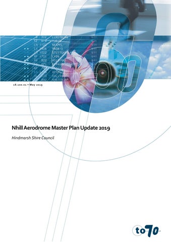
5.6.2 Airspace protection surfaces
An Obstacle Limitation Surface (OLS) has been designed for Nhill Aerodrome which defines a set of invisible surfaces above the ground around the aerodrome. The OLS generally consist of various invisible surface components with specific characteristics depending on the runway configuration. The airspace above these surfaces forms the aerodrome’s protected airspace. The OLS is designed to provide protection for aircraft flying into or out of the aerodrome when the pilot is flying by sight.
The CASA Manual of Standards Part 139 - Aerodromes defines Obstacle Limitation Surfaces (OLS) as:
“A series of planes associated with each runway at an aerodrome that defines the desirable limits to which objects may project into the airspace around the aerodrome so that aircraft operations at the aerodrome may be conducted safely.”

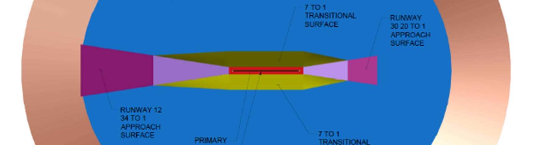

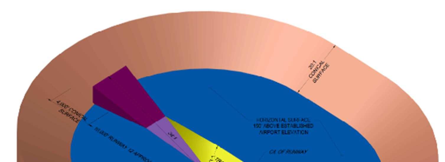
Airspace protection surfaces are critical for aerodrome safeguarding purposes, in relation to both onaerodrome and off-aerodrome development. Within the aerodrome site, airspace protection surfaces are particularly relevant for the development of landside facilities and will influence the location and height of future development on the site. Limiting the height of development close to runway(s) is critical. Future development areas on the aerodrome, particularly close to the runways, should have a maximum building height restriction applied, as per the aerodromes OLS plan, to ensure that buildings and other structures do not intrude into the applicable airspace surfaces.
The current Nhill Aerodrome OLS plan is shown in Appendix F: Obstacle Limitation Surface
5.6.3
There are currently no planning controls in place that manage applications or construction of developments near the aerodrome that may cause future issues.
A planning overlay should be available covering the land area underneath the surfaces of the OLS and non-precision approaches that ensures buildings are not constructed that penetrate these surfaces and present a danger to aircraft. For example, in regional areas it is not uncommon for mobile phone and broadband towers to cause issues for unwary airport operators
Conversely, some controls are also required to prevent the development of buildings that are sensitive to aircraft noise in areas where they could be regularly overflown. Although this is not an issue with the current level of traffic some framework should be considered in the medium term.
This Master Plan provides Council with a strategic direction and guidelines for future development of Nhill Aerodrome. It is a strategic document that aims to assist Council in planning for the next 20 years. Implementation of this plan will require a number of actions to be undertaken.
This section provides a summary of recommendations for the key issues highlighted throughout the report. Table 5 sets out the recommendations and actions, associated key trigger points and indicative timings arising from this Master Plan. The nominated period is indicative only and may change depending on a range of financial, operational, user group and community needs and demands. In addition to normal project procurement processes, some actions may require associated enabling activities such as lease renegotiations and potentially, the relocation of existing land uses / buildings.
The timings are defined as:
• Immediate term: 0-12 months
• Short term: 1-5 years
• Medium term: 5-10 years
• Long term: 10+ years
Table 5 – Master Plan recommendations No.
1 5.2.5 Hangers and airport parking Planning for hangars for private use and aircraft related businesses, including determination of existing agricultural services lease.
2 5.2.5 Hangers and airport parking Space requirements revision related to NAHC: - Seating area
- Landscaping - Aherns Hanger Extension
- Elevated viewing platform - Link to the existing flight office
3 5.3 Ground Transport Plan New entrance and signage
4 5.6.3 Planning policies & Controls
Ensure local planning controls are in place to prevent inappropriate development close to the airport
5 5.2.3 Taxiways Repair of the southern taxiway
Short/ Medium Term
6 5.2.3 Taxiways Seal and widen northern taxiway
7 5.2.2 Apron (Apron parallel taxiway) Sealed apron to accompany new hanger
8 5.2.5 Hangers and airport parking End leasing of existing ‘burn-out’ pad and removal
11 5.2.5 Hangars and airport parking Construct a new storage facility for airport related equipment
12 3.9 Heritage values Aeradio station restoration and heritage planning
5.2.5 Hangers and
with hangers and taxiway to connect to RWY 18/36, near the Aeradio Building
3.9 Heritage values Contact Heritage Victoria for population of the heritage listing.
22 3.8.1 Biodiversity Indigenous plantation to screen an adjoining duck growing shed
23 5.2.1 Runways Future sealing of the north-south runway (RWY 18/36)
6.2
Table 6 - Implementation Plan
Action
Master Plan / Strategic
Commence Community Engagement
Release of Final Masterplan
Master Plan review
Planning
Planning policies and controls
Infrastructure
Emergency Services Hub (ESH)
Private Hangar Area (PHA)
Ahern Hangar
Council approval to release the Draft Master Plan for community comment
Council adoption of the Master Plan
Adoption of the Master Plan 2019
Funding availability and agreement with Emergency Services representatives
Funding availability and planning approval, subject to demand
PHA planning stage, funding availability and demand.
2019 onwards
2020 onwards
2021 onwards
Economic Development Strategy 2015-2020, Hindmarsh Shire Council April 2015
Nhill Community Precinct Plan, Hindmarsh Shire Council September 2016
Nhill Aerodrome Master Plan, Kevin Joy Architects January 2012
VicPlan, Victorian State Government Department of Environment, Land, Water and Planning
A. Provide new entry and orientation signage adjoining the airport entry road at Aerodrome Road. Signage to include reference to:
a. Nhill Aviation Heritage Centre
b. Restored Avro Anson.
c. Nhill Ambulance Patient transfer Station.
d. Former Nhill RAAF base including historic Bellman aircraft hangar.
e. Nhill Aero Club.
B. Install street signs on corners of the original streets to provide a permanent reminder of the layout of the former Nhill RAAF base. Signs to include street names (if relevant / available) and a list of the building types that were located along the street. Refer to Sign detail.
C. Where sufficient building remains exist install a small sign in front of the building that provides a building number or code that relates to the Nhill World War Two RAAF Base brochure and associated map.
D. Manage regenerating vegetation (Including native vegetation) throughout the former RAAF Base to ensure the preservation of the original historic assets including roads, paths, drains, buildings etc. Lobby relevant Local, State and Federal Government agencies to ensure suitable finding is available to preserve the Bellman Hangar and the Flight Office, as the most intact remaining elements of the RAAF base.
E. Demolish obsolete galvanised iron fuel store.
F. New 5000 litre above ground aircraft Av-Gas fuel tank with 'Smart*' fuel management system / swipe card fuel option (for possible later installation).
G. Proposed Ambulance Transfer Station to provide protected ambulance patient transfer from ambulances to aircraft. Vehicle access to Transfer Station is by an internal road to the east and south of the Bellman Hangar.
H. Proposed Nhill Aviation Heritage Centre to Include the following buildings:
a. 30.0 x 25.0 metre sized aircraft hangar to house an Avro Anson aircraft.
b. Hangar to include an elevated viewing platform.
c. Building entry, reception area to provide a building Iink between the existing fight centre and the proposed Heritage Centre.
I. Existing Flight Office to be restored to provide a functional building that can be used in association with the aircraft hangar and associated facilities.
J. Proposed carpark associated with the Nhill Aviation Heritage Centre.
K. Proposed entry pavement from carpark to Heritage Centre including paved outdoor seating area.
L. Proposed low maintenance / low water use / low fire hazard landscaping associated with the entry to the Heritage Centre
M. Proposed future extension of Nhill Aviation Heritage Centre hangar with a door opening to the north.
N. Proposed 1200mm high (nom.) fence to separate visitors to the Nhill Aviation Heritage Centre from the airport operations area. Chain and bollards complete.
O. Proposed long-vehicle parking (i.e. caravans / coaches). Upgrade existing RAAF road to a sufficient standard to allow year-round use for large vehicles (including emergency vehicles) to provide a one-way internal loop road within the site.
P. Aeradio station building and grounds to be restored
Q. Proposed air park including residences with attached private hangars (hangar dimensions shown are 15 x 12 metres) with direct taxiway access from the runway.
R. Proposed taxi-way and private plane parking at airpark.
S. Proposed land purchase to allow an extension to the length of the main runway. Length of proposed runway extension as shown is 175 metres.
T. Proposed aerodrome storage shed. Nominal shed size shown is 10.0x12.0 metres with direct access from taxi-way and Ambulance Transfer Station access road.
U. Proposed aerodrome caretaker’s residence (Indicative footprint).
V. Proposed leasehold for commercial use (i.e. possible solar energy generation).
W. Proposed indigenous plantation (nominal width 9.0 metres) to screen adjoining duck growing shed.
X. Proposed aircraft related light Industry - with direct access to the taxiway on the western side and truck access on the eastern side of the shed.
Y. Future sealing of north-south runway.
Z. Proposed camping areas for self-contained vehicles (2,700m sq.) subject to survey of RAAF building remnants including the former latrine, salvage shed, canteen & base theatre.


36 TAKE OFF END