KARURA PARTICIPATORY FOREST MANAGEMENT PLAN
This Karura Participatory Forest Management Plan is hereby approved. The plan may be amended as the need arises through mutual agreement of both parties. Its implementation will be guided by the Forest Management Agreement signed between the Kenya Forest Service and the Friends of Karura Community Forest Association and will be based on approved annual work plans.

DEDICATION
This management plan is dedicated to the late Professor Wangari Maathai, Nobel Peace Prize laureate and founder of the Green Belt Movement. Professor Maathai is internationally recognized for her persistent struggle for democracy, human rights and environmental conservation. In the 1990s, Professor Maathai challenged a planned settlement in Karura Forest Reserve, risking jail and bodily harm to preserve the forest for generations to come. If not for Professor Maathai's vindication and bravery, the trees and their ecosystem would not be there.
"I have invested 20 years of my life in this campaign for the environment and I'm still only scratching the surface. I am confident of winning. Nobody will build anything [in the forest] as long as we live. We cannot dignify theft."
Prof. Wangari Maathai, rededicating herself to the fight to save Karura Forest, Nairobi, 2001

“When the land-grabbing happened, there was just one Wangari and a few others who were willing to risk their lives to stop the illegal developers, and Karura today is the result. I tell you if this happens in the future, it must be the voice of all Kenyans that rises in protest. And if you don't protest, you do a great disservice to your children and their children's children.”
Prof. Wangari Maathai, on her last visit to Karura Forest, March 2011
Planning Committee
FOREWORD
Karura Forest Reserve is situated in the outskirts of Kenya's capital city, Nairobi. This remarkable geographical location gives the forest a unique role in Nairobi and Kenya as an urban recreational conservation forest. The dense population surrounding the forest, including two informal settlements and several more affluent areas, has led to high demand for forest resources. These demands include ecotourism and recreation, fuelwood, water, and beekeeping. The Forest Conservation and Management Act, 2016 and the KFS Strategic Plan have ushered in a new era in forest management in Kenya, with a dispensation that allows the involvement of adjacent communities in forest management. This follows a similar shift in legislative change in other East African countries, such as Tanzania and Uganda. Contrary to past practice where management was centralised, many countries around the world have embraced a participatory approach to the management of forests, and the practice is now widely accepted as a sustainable way of managing natural resources.
A key requirement of the new legislation is that all forests will henceforth be managed in accordance with a management plan. In the Participatory Forest Management context, stakeholders are expected to prepare a Karura Participatory Forest Management Plan (KPFMP) to guide the process of managing the resources of the forest. To achieve this, the legislation has provided for the formation and registration of Community Forest Associations (CFAs). In Karura, this led to the formation of Friends of Karura CFA (FKFCFA). In order to prepare the participatory plan, a planning team was formed with its members drawn from all key stakeholders. Kenya Forest Service (KFS), FKFCFA and the Nairobi Conservancy Forest Conservation Committee (NCFCC) collaborated to prepare the first and second management plans for Karura forest as they have also done to draft this third management plan
It is hoped that by its adoption, sustainable management of the Karura Forest Reserve will continue to be realized. The FKFCFA Board wishes, together with the KFS, to celebrate the tremendous strides that have been made in conserving Karura Forest, providing a sterling example of successful participatory forest conservation and management. We look forward to even more cooperation and growth under the joint management plan with KFS in the years to come guided by our vision which is to make Karura Forest Reserve a world-class example of a sustainably managed and conserved, safe and secure natural forest.

ACKNOWLEDGEMENTS
The development of this Karura Participatory Forest Management Plan has been a combined effort of different stakeholders which included the Kenya Forest Service (KFS), the community, and Friends of Karura Community Forest Association (FKFCFA)


Special mention goes to KFS staff led by Dr. Elizabeth Wambugu, the Head of Forest Management Planning, whose office provided the guidelines for revising management plan and also for organizing and improving the initial drafts. The LPRC would also wish to acknowledge the efforts of Mr. Francis Kariuki, Head of Nairobi Conservancy, Mr. Anthony Kinyanjui, Ecosystem Conservator Nairobi and Mr. Paul Musembi, the Forest Station Manager Karura for their invaluable advice throughout the plan preparation process.
The Local Plan Revising Committee (LPRC) would like to show its appreciation to the members of FKFCFA for their contribution, particularly Mrs. Cristina Boelcke, Mrs. Chantal Mariotte and Dr Harvey Croze from the FKFCFA, for their invaluable inputs and the sacrifice of their time and efforts to make the production of this plan a success.
Since it would be difficult to mention each and every stakeholder who in one way or the other took part in this noble work, all their efforts are highly appreciated and acknowledged.
EXECUTIVE SUMMARY
The forest covers an area of 1041.3ha and is comprised of two blocks namely Karura (including Mazingira) and Sigiria. The Karura Participatory Forest Management Plan (KPFMP) will be implemented over five years. Karura is an urban forest that caters for a wide clientele whose demands range from subsistence needs to recreation and aesthetics, for the poor and affluent respectively.
The vision of the KPFMP is to ”keep Karura Forest safe and secure, and a world-class example of sustainable forest management and conservation”.
The goal of the KPFMP is to achieve and sustain a conserved Karura Forest through stakeholder's participation for provision of ecosystem goods and services for the city residents and beyond.
The overall objective of the KPFMP is to have Karura Forest managed and sustainably conserved for provision of recreational and ecosystem goods and services to Nairobi residents and beyond.
The KPFMP will be the framework to moderate the participation of stakeholders, besides ensuring that the implementation leads to the sustainable management of the forest. To achieve these, the forest has been divided into four zones namely natural forest, wetlands, plantations and developed areas, each of which is put under a different management regime.
The threats and constraints to the conservation of the forest include:
1) Pressure from developers to claim land for building due to the prime location of Karura Forest.
2) Forest fires during dry periods.
3) Invasive plants like Lantana camara and other invasive weeds which grow vigorously, compromising the re-establishment and growth of indigenous plants and trees.
The specific management objectives that will guide the implementation of the KPFMP are:
1) To rehabilitate degraded parts of Karura Forest to a healthy, productive indigenous closedcanopy forest as well as ensuring the achievement of sustainable management in order to enhance forest habitat for indigenous wildlife species, conserve biodiversity, and protect water resources.
2) To keep the forest safe and secure for the enjoyment of all through the continual protection of the forest from any high impact development other than forestry activities and, ensuring ecotourism proposals are in the best interest of the forest.
3) To contribute to the improvement of the livelihood of local communities adjacent to the forest.
4) To make Karura an accessible conservation forest readily available to all for purposes of low-impact, sustainable eco-tourism.
5) To promote environmental education, and research in forestry.
6) To have in place the necessary infrastructure, vehicles machinery and equipment.
7) To provide optimum human resources for implementing the management plan.
The KPFMP further provides for monitoring and evaluation of the planned activities and its revision.
LIST OF ACRONYMS/ABBREVIATIONS
AFEW African Fund for Endangered Wildlife
BIEA British Institute in Eastern Africa
BP British Petroleum
CBOs Community Based Organizations
CFA Community Forest Association
CID Criminal Investigation Department
CSR Corporate Social Responsibility
ESRI-EA Environmental Systems Research Institute – East Africa
FCC Forest Conservation Committee
FKFCFA Friends of Karura Community Forest Association
FMA Forest Management Agreement
ICIPE International Centre of Insect Physiology and Ecology
ICRAF International Centre for Research in Agroforestry/World Agroforestry Centre
IUCN International Union for Conservation of Nature
JMC Joint Management Committee
KEFRI Kenya Forestry Research Institute
KFEET Karura Forest Environmental Educational Trust
KFS Kenya Forest Service
KPMG Klynveld Peat Marwick Goerdeler
L.N. Legal Notice
M&E Monitoring and Evaluation
NBEs Nature-Based Enterprises
NMK National Museums of Kenya
Proc. Proclamation
KPFMP Karura Participatory Forest Management Plan
RA Residents’ Association
SUB-COMP Sub Compartment
TBP Tropical Biodiversity Project
UN United Nations
UNEP United Nations Environment Programme
UNON United Nations Office, Nairobi
UTM Universal Transvers Mercator
APPENDICES
APPENDIX 1: LIST OF PARTICIPANTS IN STAKEHOLDERS’ MEETINGS
APPENDIX 2: SMALL-MEDIUM MAMMALS FOUND IN KARURA FOREST
APPENDIX 3: INDIGENOUS TREES IN KARURA FOREST
APPENDIX 4: KENYA FOREST SERVICE (KFS) AND FRIENDS OF KARURA FOREST (FKFCFA)STAKEHOLDER ENGAGEMENT POLICY FOR TREE PLANTING IN KARURA FOREST
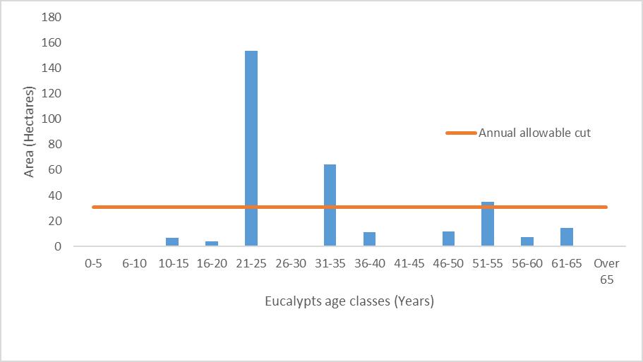
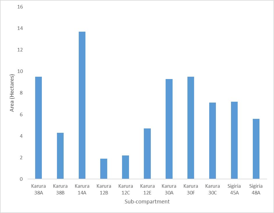
APPENDIX 5: PROPOSED FELLING PLAN FOR KARURA FOREST PLANTATIONS
APPENDIX 6: INSTITUTIONAL ARRANGEMENTS FOR PLAN IMPLEMENTATION
LIST OF FIGURES
Figure 1: Karura Forest geographical location map 7
Figure 2: Karura Forest seasonality of rainfall __________________________________________ 9
Figure 3: Karura Forest annual rainfall since 1996 _______________________________________ 10
Figure 4: Ecotourism sites in Karura Forest 15
Figure 5: Annual visits to Karura Forest since 2010 ______________________________________ 19
Figure 6: Karura Forest Zonation map 36
Figure 7: Clearing and replanting targets map, 2021-2026 ________________________________ 40
Figure 8: Gross annual income to Karura Forest 2019-2019 50
LIST OF PLATES
Plate 1: Karura River above the main waterfall 12
Plate 2: A cave in the forest: the main Mau-mau Cave 32
Plate 3: The Karura River waterfall 33
Plate 4: Signage at Junction 5 33
Plate 5: The Meditation Area near Ruaka Picnic Site 33
Plate 6: Wangari’s Grove _______________ 33
Plate 7: Waterfall on Ruaka River: aeration in action 34
Plate 8: Two zone types: indigenous forest and over-mature exotic plantation________________ 36
Plate 9: Strategic clearing of invasives and plant of indigenous species ______________________ 38
Plate 10: Karura Forest Tree and Shrub Nurseries 40
Plate 11 & 12: Participants at Stakeholders’ Meeting, 21 February 2020 ______________Appendix 1
LIST OF TABLES
Table 1: Meetings of the JMC and the FKFCFA board ________________________________ 2
Table 2: Status of the implementation of the previous plan _______________________________ 5
Table 3: History of alteration of boundaries of Karura Forest Reserve 8
Table 4: distribution and status of Karura forest areas ___________________________________ 8
Table 5: Karura Forest Area Statement as of 2019 13
Table 6: Ecotourism sites in Karura Forest 14
Table 7: infrastructure in Karura Forest 16
Table 8: KFS staff component in Karura Forest 16
Table 9: JMC through FKFCFA staff component 16
Table 10: FKF Board and the Joint Management Committee 18
Table 11: Stakeholders' roles and responsibilities 21
Table 12: Zonation criteria (2020-2024) 36
Table 13: Summary of management actions for Rehabilitation and Management Programme 39
Table 14: Areas to be cleared of invasives and exotic plantation, replanted with indigenous _____ 40
Table 15: Summary of management actions for Forest Protection and Security Programme 41
Table 16: Summary of management actions for the Community & Outreach Programme _______ 43
Table 17: Summary of management actions for the Ecotourism Programme ________________ 44
Table 18: Summary of management actions for Environmental Education, and Research Programme 46
Table 19: Summary of management actions for the Infrastructure & equipment programme 47
Table 20: Summary of management actions for the Human Resources Programme 48
Table 21 Karura Forest Station revenue collection 2015/16–2020/21 49
Table 22: Revenues from Gates, picnics, and other events 49
Table 23: Revenue protections 2021-2025 50
Table 24: Summary of negative impacts and mitigation measures of planned activities 52
Table 25: Monitoring indicators 53
1. INTRODUCTION
This is the management plan for Karura Forest covering an area of 1,041.3 Ha. The forest comprises two blocks, namely Karura and Sigiria. The forest comprises of both natural forest and exotic plantations and is an urban recreational conservation forest in the capital city of Nairobi.
1.1. JUSTIFICATION
According to section 47 of the Forest Conservation and Management of Act 2016, all forests must be managed under a management plan. For the last 10 years, Karura Forest Reserve has been very successfully managed according to its first two participatory forest management plans. Previously the Forest Department, the predecessor of KFS, was responsible for all management actions and was not obliged to consult with other stakeholders. This was because there was no legal provision to allow for the active involvement and participation of stakeholders in forest management. It is during this period (in the 90s) that attempts were made to excise vast areas of the forest due to lack of stakeholder participation.
Karura Forest Reserve is a prime example of well-designed and successfully implemented participatory forest management plans. The first two participatory forest management plans have indicated that the management of the forest should be driven towards the achievement of a defined long-term vision for the forest, and the management decisions should not be made based on current considerations or influenced by factors other than the long-term sustainability of the resource. The current plan duration is from 2016 to 2020 and hence necessitates revision to also include the current aspirations of KFS, FKFCFA and other stakeholders as well take in consideration of contemporary issues.
1.2. APPROACH TO PLAN DEVELOPMENT
A consultation process was undertaken in the development of the third management plan, with key stakeholders contributing to its final form. The approach followed to develop this plan aimed at ensuring the sustainability of the forest by designing activities geared towards the achievement of defined objectives in the short-term and the planned future.
FKFCFA kicked off the consultative process with a retreat held in Naivasha from Feb 6 to 8 2019, the KPFMP being a major item on the agenda. All representatives of the community took part in this extensive discussion and had an opportunity to express their community’s views and make their suggestions on all aspects of the plan.
Following this exercise, the Joint Management Committee (JMC) set up a drafting committee composed of two KFS and three FKFCFA staff. The drafting committee held five face-to-face meetings and had several dozen digital exchanges throughout the process. Consultations with the KFS management plans department were held on three occasions for guidance as the plan was being drafted. Progress was discussed and consultations held at 11 meetings of the JMC and 3 FKFCFA Board meetings (Table 1).
Table 1: Meetings of the JMC and the FKFCFA board where the KPFMP was discussed

A combined JMC and FKFCFA Board meeting was held on 5 February 2020.
A stakeholder meeting with the communities from Huruma, Githogoro and Deep Sea was held on 7 February 2020.
The full stakeholder meeting was held on 25 February 2020. The draft KPMFP was thoroughly reviewed, and all agreed amendments included in the final text (Appendix 1).
1.3. TITLE AND DURATION OF THE PLAN
The plan shall be referred to as Karura Forest Participatory Forest Management Plan (KFPMFP). This plan covers five years starting from 26 April 2021 to 25 April 2026.
1.4. IMPLEMENTATION OF THE PLAN
The KPFMP shall be implemented by the KFS and FKFCFA guided by a Forest Management Agreement. All activities in the forest must be approved by the KFS & FKFCFA Joint Management Committee. Any development or project outside this plan must be approved by the Chief Conservator of Forests.
1.4.1. FUNDING FOR THE PLAN
The funding of the KPFMP will come from accrued revenue, KFS, FKFCFA, and development partner support.
1.4.2. AMENDMENTS AND REVISION OF THE PLAN
The monitoring and evaluation process which will be carried out throughout the plan. This will show whether amendments or revisions are needed as the plan is being implemented.
1.5.
STATUS OF IMPLEMENTATION OF THE PREVIOUS PLAN
To date, a wide number of stakeholders have worked with KFS and FKFCFA in the forest. They have committed themselves to the goals and vision outlined in this third management plan. The achievements of the previous plan are as follows: Natural forest management programme
• 143 ha of degraded plantation and indigenous sites in the forest have been cleared of invasive species and planted with suitable indigenous species.
• To supplement the Karura KFS nursery, a new nursery for indigenous trees and shrubs was established by the CFA to supply a wide variety of species sourced mostly from the forest to the regeneration program. All seedlings planted in the forest come from the nursery to ensure good quality and suitability.
• 49.6 ha of old eucalyptus stands have been felled and planted with indigenous species in the Northern part of the forest.
• New, innovative practices have been designed and used to get rid of eucalyptus stumps in cleared areas such as the monthly cutting back of young coppices.
Participatory forest management programme
• The Forest Management Agreement between KFS and FKFCFA was renewed.
• Cooperation between KFS and FKFCFA has been enhanced with the Forest Station Manager and his staff moving into Karura Forest House, the new office block shared by KFS and FKFCFA staff.
• The KFS & FKFCFA joint management committee meets every month to review activities, issues and take appropriate decisions including on financial matters.
• Relations with the FCC were strengthened with an official visit of the FCC to Karura on 23 February 2019.
• FKFCFA enjoys widespread support due to its good governance and has been able to mobilise funds to implement various projects in the forest.
• Due to this outstanding success, the partnership between KFS and FKFCFA as a model for other CFAs throughout the country who make knowledge visits.
• Workshops with other CFAs in the Conservancy were held including one as part of the FKFCFA 10th anniversary activities
• Nairobi CFAs have a representative on the FCC.
Forest safety and security programme
• 152 illegal title deeds have been recommended by the Land Commission to be revoked Two Court cases are on-going involving others.
• There have been no serious security incidents in the forest since it has been open to the public. Sufficient funds were raised to fully secure the forest with a 15 km electric fence and patrols by 55 FKFCFA Scouts and 11 KFS Rangers.
• The fence is monitored and maintained daily, entry/exit points manned permanently by gate clerks, scouts, and Rangers.
• the risk of fire in the forest has been minimized through the systematic clearing of Lantana camara and Mauritius thorn. Lighting fires and smoking are strictly forbidden in the forest. Training of all staff in firefighting is carried out regularly.
Local communities’ livelihood programme
• All surrounding communities both affluent and less affluent are represented on the FKFCFA board.
• The Joint KFS & FKFCFA committee where all decisions are made ensures all voices can be heard.
• The local communities have benefited considerably from the new management regime. The forest is no longer a place of danger for them but a source of many opportunities.
• The Joint Committee through FKFCFA employs 101 permanent staff, most of them from the surrounding informal settlements. All forestry contract work done in the forest is given out to women's and other groups from those villages. This amounted to KES 1,200,000 per month on average spent on contracts or casual labour.
• A bursary program has been set up by FKFCFA to support children of the community with secondary school fees. Over 100 candidates have benefited so far.
Environmental education, ecotourism and research programme
• The list of bird species has grown from 113 to 220 according to Nature Kenya which organizes regular bird-watching visits.
• Indigenous orchids which had disappeared from the forest through poaching and were reintroduced with help from the Kenya Orchids Society have been thriving and spreading in the forest.
• Nine motion-activated day and night cameras continue to reveal animal species never recorded before in the forest and shed knowledge on their abundance. These include stripped jackal, palm civet and clawless otters.
• The abundance of wildlife, in general, has increased significantly in the absence of poaching. Animals have become much less shy of people and are easily seen adding value to visits to the forest. (See the list of medium to large mammal species in Appendix 2)
• The Colobus monkey project continues to be very successful as their population has reached 184 individuals from 142 introduced in 2014. The project has been showcased at international primatology meetings, increasing Karura’s visibility globally.
• Two pairs of African crowned eagles have returned and have successfully nested and fledged chicks in the forest testifying to the recovering health of the ecosystem
• A study of the carbon-storing capacity of the forest has been carried out by an ICRAF sponsored student showed that the carbon-storing capacity of Karura averages at 37.62t/ha.
• A guidebook of Karura describing the history and biodiversity of the forest has been published by FKFCFA in 2019 entitled Karura Forest – A Visitors’ Guide
• Some Karura-based educational tools have been designed for school visits.
• Due to the vast improvement in security and infrastructure, the number of visitors to the forest has grown significantly over the last ten years and has reached an average of nearly 40,000 a month from practically none in 2009. Karura is now the No 3 attraction to visit in Nairobi according to Trip advisor and it has been awarded a “Certificate of Excellence” for five years running. The vast majority of visitors are Kenyans showing that there is real national ownership of Karura forest which has been dubbed "the people's forest". People come in large numbers to walk, jog, cycle or just enjoy being in a natural setting.
• Karura now has five picnic sites, Amani, KFEET, Ruaka, Sigiria and Karura Gardens (Figure 4).
• Forest rules have been developed and clearly displayed at all entry points to regulate visitors' behaviour in the forest.
• An attractive website has been designed and is regularly updated and populated with interesting articles. The Facebook page Friends of Karura Forest is also very active and has attracted so far over 23,000 page-likes.
• The Joint Committee and Karura Forest Environmental Education Trust (KFEET) have jointly employed an education officer who takes school parties and special interest groups on educational tours of the forest. Thousands of school children visit the forest every year and get a chance to learn about forests and the environment thanks to a teaching program targeting different age groups.
• FKFCFA has set up a sponsored visit project for underprivileged schools and orphanages, providing them with transport and lunch so that their pupils have a chance to visit the forest.
• A 1.6 km circuit for physically challenged visitors, the Matembezi Trail, has been built in Sigiria.
Infrastructure and equipment
• A 700m2, state of the art office block has been built to house KFS Karura station and FKFCFA staff
• Over 50 km of track and trails are being maintained.
• Nine bridges have been built and five culverts installed and maintained.
• Signage is being renewed and maintained throughout the whole network of tracks including 5 circuits of different lengths.
• The map of the forest has been updated four times to guide visitors.
• Monkey-proof litter bins and 150 benches have been put at various places along the tracks.
• 70 picnic tables at the various picnic areas installed and maintained.
• Entry gates, washroom and storage facilities have been improved at Gate-A on Limuru road, Gate-C on Kiambu Road, and Gate-F on Thigiri Lane.
• Bio-digesters recycling plants have been installed at the office block/Karura Forest House, Limuru Road Gate-A, Amani picnic site, Gate-F, and KFEET.
Table 2: Status of the implementation of the previous plan No. Management programme Activities Plan
1 Rehabilitation and management programme Revert ageing plantation into natural forest 15 ha per year 143 ha regenerated Nursery created producing sufficient seedlings
2 Participatory forest management programme Joint implementation of KPFMP and management of the forest
meetings and consultations Monthly meetings of JMC 7 fields visits and workshops held with other CFA’s
3 Forest safety and security programme Secure the forest land Keep the forest secure Acquire title deed for the forest Security incidents extremely rare 152 illegal title deeds revoked Success in 1 land grabbing court case
4 Local communities livelihoods programme Contribute to the needs of the community Create jobs and IGA’s 85 permanent jobs created 1,000 man/day per month worth of contract work
Invasive species, logging ban availability of seedlings of suitable species
Other CFA’s stages of development
Slowness of procedure to acquire a title deed for the forest
Need for full transparency in awarding contracts
5
6
7
1.6. LESSONS LEARNED
1.6.1. Forest regeneration
Planting should exclusively take place during the long and short rainy seasons. A wide variety of suitable indigenous species needs to be available in sufficient numbers at the FKFCFA nursery.
1.6.2. Local communities
The awarding of contract work should be done in a fully transparent manner to ensure the relationship with the community remains good.
Social projects benefiting the community such as the FKFCFA bursary fund should be continued as they ensure ownership of the forest by the community.
2. DESCRIPTION OF KARURA FOREST RESERVE
2.1.
GEOGRAPHICAL LOCATION
Karura Forest Reserve is situated in the northern part of Nairobi Municipality. Its boundaries fall within a rectangle having a northwest corner at UTM 37M 254354m E 9864755m S and a southeast corner at 262196m E 9861072m S. It forms part of the Nairobi River basin. See Figure 1.
The Forest comprises three sections separated by the Limuru and Kiambu Roads.
The western section (known as Sigiria) is delineated by a cut and beaconed line along its boundary with the residential area of New Muthaiga to the west, the residential areas of Gigiri/Rosslyn to the north (along the Thigiri River, a tributary of the Getathuru River), Limuru Road to the east and the Getathuru River to the south.
The middle section is bound by a cut and beaconed line along Limuru Road, the residential area of Muthaiga North and Runda to the west, Rui-Ruaka River, Huruma village, a road, and residential estates to the north, Kiambu Road to the east, and Getathuru River to the south.
The eastern section (Mazingira) is bound by the Kiambu Road to its west, Thika Road to the east, and Muthaiga Golf Club to the south (to which it yields an extension).

2.2. LEGAL AND ADMINISTRATIVE STATUS
Karura Forest Reserve was gazetted in 1932 through Proclamation No. 44. The Forest became a Central Government Forest Reserve in 1964, through Legal Notice 174. Since its establishment in 1932, the forest has been affected by 5 excisions totalling approx. 114Ha as shown in Table 2.
Table 3: History of alteration of boundaries of Karura Forest Reserve Year Proclamation / Legal Notice Action
(Source - KFS Survey Unit)
Over the years, gazetted forestland in Karura has been allocated or leased to national and international public institutions.
Administrative status
The forest is divided into two blocks comprised of five beats jointly managed by KFS and FKFCFA under the Joint Management Committee (JMC). There used to be three outposts. Only one remains at Limuru Gate-A while the other two were abandoned. These are the one in Sigiria due to old age and the other next to BP Shell Club due to insecurity (Table 4).
The forest reserve has a Forest Station Manager under the Ecosystem Conservator Nairobi, within Nairobi Conservancy. The Forest Station Manager and the FKFCFA Operations Manager oversee daily activities of their respective staffs under the guidance of the JMC.
Table 4: Distribution and status of of Karura Forest areas
Block Area (Ha) Remarks Outposts and status
Karura & Eastern Salient (Mazingira)
Sigiria
797.3 This is the largest block and houses the KFS Headquarters No longer exist except at Limuru gate
244.0 Features a large marshland. Well protected by the adjacent residential areas. No longer exist
Total 1,041.3
2.3. Biophysical Description
2.3.1. Topography
The topography of Karura is gently rolling, occasioned by shallow valleys. Drainage is generally in the southerly and eastern direction. Susceptible depressions in the Western Section of Karura called Sigiria forest hold small local swamps which are threatened by eucalyptus trees. The highest point is in the northwest at 1,710m at Sigiria gate and the lowest in the southwest at 1,640m at Old Kiambu gate.
2.3.2. Climate
The climate of Karura Forest is driven by the East African bi-modal rainfall regime, characterized by two rainy seasons: March to May and October to December. The months of July and August are cold, cloudy, and dry; September to October is a temperate and dry period. January and February are typically hot and relatively dry months.

The average annual rainfall at Karura Forest was recorded over the past two decades as 1,012 mm with a maximum of 1,770 mm and a minimum of 576 mm (Fig. 2). Long-term rainfall record analysis indicates a significant trend of increasing rainfall over the past 75 years, from an annual average of ca. 800 mm over the five decades from 1945 to just over 1,000mm for the last two decades.

3: Annual rainfall totals in Karura Forest from 1996 to 2019.
Temperatures remain relatively equitable varying diurnally and with the rainy seasons between 140 and 270 C in the hot, dry seasons, and between 80 and 220.C in the cool, rainy seasons. The forest is noticeably cooler than surrounding areas throughout the year.
2.3.3. Geology
The Karura Forest lies over tertiary volcanic rocks. Volcanic tuffs with intercalated flows of basaltic lava are the common forms. Both types are occasionally exposed in the deeper river valleys, and the tuffs yield the common grey building stone of the Nairobi district. Occasionally "Chimneys" of lava are found exposed on the tops and rides of ridges as in both the Western section and Middle section of Karura.
2.3.4. Soils
The area has suffered very little tectonic or other disturbances since tertiary times, and thus the parent rocks have been weathered to great depths and giving very even soil profiles. Under natural forest the resulting soil is very deep, riddling brown clayey loam with slow but free profile drainage. Such forest floor soils become very sticky when wet but dry very quickly and tend to shrink and crack. The upper few inches of soil are usually stained dark brown with incorporated humus, but no deep litter layer develops.
Under grassland in freely drained areas, the soil is very similar to that under forest stands, but in the low-lying areas, a different soil is found. These low-lying areas are intermittently waterlogged, and the water table fluctuates greatly, and a small amount of fine soil material is usually carried in from neighbouring higher ground. Under such conditions, the soil is usually very heavy, dark grey clay, often stained black with un-decomposed humus, so-called "black cotton soils". At varying depths below this clay layer, from 2" to 3ft. below the surface,
red-brown laterite is found. It is a re-cementation product, rich in iron compounds, associated with swampy areas having a shifting water table.
Laterite, locally known as ‘murram' is useful gravel for road maintenance. Another form of ‘murram' is partially decomposed parent rock and may be found at the foot of nearly all soil profiles where the rock is sufficiently near the surface for it to be excavated. This form of ‘murram' is also popular for road surfacing but is less satisfactory than laterite. Generally, Karura Forest soils are eminently suited to tree growth, with assisted drainage in the case of swampy sites.
2.3.5.
Hydrology and Drainage
Water resource availability
Karura Forest is well-positioned for water availability as it has five rivers which flow throughout the year (not seasonally). During the rainy season, flooding happens occasionally in low lying areas. Regrettably, these rivers are heavily polluted.
Five tributaries of Nairobi River pass through Karura Forest Reserve (see Fig. 1). These are:
• The Ruaka River which separates Karura River and the Runda Residential area.
• The Karura River with traverses through the forest.
• The Getathuru River which borders the Forest along its Southern edge with Muthaiga Residential area.
• The Thigiri River (a tributary of Getathuru River) which borders the Eastern section of Karura Forest.
• The Mathare River which borders the forest on the Eastern side of Sigiria.
• Karura also has one permanent pond, two permanent wetland areas and six seasonal ones.
• There are five waterfalls in the forest, of which two are accessible to visitors
The Nairobi City Council also supplies water, for which a monthly charge is paid. The rehabilitated old borehole at Amani Gardens also provides water which irrigates the picnic grounds during the dry season.
Preliminary analyses have shown that the rivers are highly polluted with coliform bacteria, presumably from poor sewage treatment in the surrounding neighbourhoods: titers from sample points as the streams enter the forest were >2,500 cfu. There is some evidence that the streams enjoy some reduction of the bacterial load as they pass through the forest, but the journey is not long enough to result in a significant reduction.
Water utilization and demand
The main KFS indigenous tree nursery uses water from the Karura River and the Nairobi City Council. The small KFS tree nursery uses water from the Nairobi City Council. The tree biotechnology nursery has its own borehole to ensure a pure water source. The FKFCFA nursery uses water from the Amani borehole. The policy for tree planting is now to always plant during the rainy season.
Groundwater is recharged naturally by rain and by rivers. Recharge may be impeded somewhat by human activities including paving, development, or logging. These activities can result in loss of topsoil resulting in reduced water infiltration, enhanced surface runoff and reduction in recharge. Use of groundwater, especially for irrigation, may also lower the water
table. Groundwater recharge is an important process for sustainable groundwater management since the volume-rate abstracted in the long term should be less than or equal to the volume-rate that is recharged.
Therefore, enrichment planting with bamboo and other species is necessary. Wetlands must also be conserved for biodiversity.

2.4.
BIODIVERSITY DESCRIPTION
2.4.1. Flora
Forest plantations remaining after the past ten years’ clearing and replanting currently cover 353.5 ha and comprise species such as Araucaria cunninghamii, Eucalyptus saligna, Eucalyptus globulus, Cuppressus torulosa and Cuppressus lusitanica.
Almost all the plantations in the forest have passed their economic rotation age and are therefore succumbing to age-related mortality. The Eucalyptus spp. range from 38-93 years, Araucaria cunninghamii (44-56 years), Cuppressus torulosa(34-56 years).
Indigenous forest covers 383 Ha (of which 212 is original upland sclerophyllous forest and the rest are areas restocked or replanted with indigenous (after clearing of plantations and invasive shrubs) and are comprised of species such as Olea europeae var. africana, Croton megalocarpus, Warburgia ugandensis (Muthiga), Brachyleana huillensis (Muhugu), Uvaridendron anisatum, Markhamia lutea, Teclea nobilis, Juniperus procera (Cedar), Craebean brownii, Newtonia buchananii, Salvadora persica, Ficus thonningii, Trichilia emetica, Calondendrum capense and Dombeya goetzenii. Appendix 3 shows a list of Karura’s most prominent indigenous species, some of which are endemic or rare.
The area of the forest is further subdivided as shown in Table 6. The "Other" category also covers all the area occupied by buildings, tree nurseries and other facilities.
Table 5: Karura Forest Area Statement as of 2021 based on various survey and mapping exercises, and registering of clearing and planting exercises over the past ten years (in hectares).
1Includes the KFS HQ enclave, the Tree Biotechnology Project, the KFS nursery.
2 Includes allocated and leased areas, e.g., Muthaiga Golf Club, DCID headquarters, NSIS.
• The main Karura block and the Mazingira (Eastern Salient) block sum to 786.5 ha. Reported areas are not cadastral but indicative from various sources such as old paper maps, ground surveys with GPS instruments and delineations on Google Earth satellite coverages.
• Indigenous Forest comprises the original forest components such as the pristine Karura River valley and central portions of the forest that were logged over for large trees in the early 20th century
• Cleared Plantation Restored with Indigenous comprises areas cleared of Lantana camara shrubs and exotic plantation trees and replanted with indigenous species by FKFCFA and KFS.
• Plantation Restored with Indigenous broadly describes areas that have been cleared of Lantana camara shrubs allowing existing indigenous wildlings to survive, assisted with enrichment re-planting. A number of exotic emergent trees remain.
• Degraded Indigenous Restored refers to areas of Degraded Indigenous that have been cleared of Lantana camara and Mauritius Thorn shrubs and the remaining indigenous trees and shrubs allowed to thrive, in some cases with enrichment planting.
• Exotic Plantation Remaining comprises areas of Eucalyptus, Araucaria and Cypress stands that were planted on clear-felled areas between 1912 and 1990 and that have not yet been cleared and replanted with indigenous species.
Additionally, there are many shrubs which have wide local medicinal uses Strychnos henningsii (Muteta), Erythrococca bonge∆nsis (Muharangware), Vangueria madagascariensis (Mubiro), Rhamnusprinoides (Mukarakinga), Caesalpiniavolkensii (Mubuthi), Solanum spp. (Mutongu), Eleodendronbuchananii (Mutanga) and Rhusnatalensis (Muthigio).
The riparian belts along rivers Getathuro and Ruaka are partly covered by Arudinariaalpina, the Kenya native bamboo species. The exotic giant bamboo Dendrocalamusgiganteus is mainly found growing within the area of the tree nursery along Karura River where it was introduced in the past. Additionally, there are three wetlands which occupy 10.5Ha. These serve as important habitats for birds and therefore are ideal areas for bird watchers.
2.4.2. Fauna
The motion-activated camera traps have shown that the forest hosts around 22 different varieties of mammals . These include Harvey's duikers, suni, bushbucks, bushpigs, genets, civets, bushbabies, porcupines, sykes monkeys, squirrels, hares, epauletted-bat, giant pouched rats, white-tailed mongoose, clawless otters, side-striped jackals (see Appendix 2). Colobus guereza kikuyense (Colobus monkey) have been translocated to the forest from rapidly disappearing habitats in the Mount Kipipiri area.
Reptiles include rock pythons, and various other snake and lizard species.
2.4.3. Avifauna
Some 220 bird species have been observed in Karura Forest. They include African crowned eagle, Ayres Hawk-eagle, crows, owls, sparrows, doves, weavers, Hartlaub's Turaco and Narina Trogon.
2.5. OTHER RESOURCES
2.5.1. Non-wood resources
Karura being a recreational conservation forest, only non-consumptive activities are permitted.
There is limited honey production by the surrounding community.
Seeds and wildlings are collected in the forest by the KFS and the FKFCFA nursery sustainably.
2.5.2. Ecotourism
The forest features a 15-metre waterfall, caves that are considered sacred by many and have historic value because of their use during the days of the Mau Mau. An archaeological survey of the caves carried out by NMK has revealed stone tools and other artefacts dated 4 500 years old and others estimated at between 50 and 300 000 years old, the middle stone age period. There are also marshlands which attract birdlife, a wide diversity of indigenous trees, Lilly Lake, Amani Garden, beautiful nature trails and Wangari Maathai corner. This is the place where Professor Wangari Maathai (Nobel Peace Prize winner) was attacked for standing up to the developers hoping to grab the area of land to the north of the Karura River. See Fig. 4, following page. Other ecotourism amenities include four picnic sites and two eateries (Table 7).
Table 6: Ecotourism sites in Karura Forest
Walking, jogging
Horseback riding
km of trails

2.5.3. Infrastructure and Equipment
Supporting infrastructure is spread out throughout the forest such as washroom facilities and bridges. There are 4 gates with gate house, water, electricity and internet open to the public and two service gates. There is a state-of-the-art office block at Limuru gate housing KFS Karura station and FKFCFA staff.
Table 7: Infrastructure in Karura forest
The station manager has a double-cab 4x4 pick up, two motorbikes and a tractor, trailer and bowser. FKFCFA fields a 4x4 pickup and seven motorcycles to be used in the forest.
2.5.4. Human resources
At present 30 people are employed by KFS at the forest station, namely: One Forest Station Manager, one Assistant Station Manager, 11 Rangers, and 15 casuals.
Table 8: KFS staff component in Karura forest
The Joint Management Committee through FKFCFA employs 101 persons as scouts, clerks, tree-carers, administrative staff, and many casual workers for clearing and planting in the forest.
Table 9: JMC through FKFCFA staff component in Karura Forest
2.6. HISTORY OF KARURA FOREST RESERVE
2.6.1. Pre-gazettement
During the pre-colonial period, Karura Forest is believed to have been “claimed” by various Gikuyu families. The forest was surrendered to the British Government at the time of colonization allegedly on condition that it remained forest land.
2.6.2.
Post-gazettement
Karura Forest was gazetted in 1932 and was one of the earliest forests in Kenya to be recognised as a Reserve.
The first experimental plantations in Karura were made in 1906. At that time various species of Eucalyptus and some Cypress were tried. In the initial stages, the Forest was comprised principally of a natural forest of Brachylaena huillensis (Muhugu), Croton megalocarpus and Warburgia ugandensis (Muthiga). Up to 1935, it was fashionable to plant a certain proportion of indigenous species, either pure or in mixture with Eucalyptus. However, when Eucalyptus was found to grow extremely fast, the natural forest was reduced over the years and replanted with this species. Eucalyptus provided fuel wood at a rotation age of twelve (12) years whilst it was estimated that the natural forest would require seventy years to reach an equivalent girth and volume. This wood was used to provide fuel wood for the railways, poles to carry electrical wires, and for the construction industry.
With time and based on the ever-pressing demands for fuel from the adjacent and fastgrowing metropolis of Nairobi, Eucalyptus became the principal species planted almost to the exclusion of all others. Another species Araucaria cunninghamii was established, made good progress and proved a possible alternative to Eucalyptus for planting in Karura, but its fuelwood rotation of fifty (50) years was too long in comparison.
Demand for fuel and construction material in Nairobi from 1950 - 1970 increased with a growing African and Asian population despite the existence of other forms of fuel such as electricity and paraffin.
The plantations in Karura were established through the ‘shamba’ (farm) or Taungya system. Kenya's shamba system has been generally defined as a form of forestry, where farmers are encouraged to cultivate primary crops (maize, cabbages, potatoes, beans, and carrots) on previously clear-cut public forest land on the condition that they replant trees. Since the mid20th century, Kenya adopted this system to establish tree plantations using cheap or free labour, to meet the demand for timber and wood products.
2.7. CFA FORMATION PROCESS AND STATUS
Friends of Karura Community Forest Association (FKFCFA) was registered in October 2009 and designated by KFS as the CFA for Karura Forest Reserve. Its categories of members consist of individual, families, corporates, and people bordering the forest who have a registered neighbourhood association. Such associations are invited to designate a representative member who may take a seat on the FKFCFA board.
FKFCFA has a constitution that specifies how the association is to be run and is registered by the Registrar of Societies under Cap 108. FKFCFA has a board of 18 members composed of the Chairperson, two vice-Chairpersons, Secretary, Treasurer, Assistant Treasurer and three committee members elected at the AGM (Table 10). The others are ex-officio representatives chosen by each neighbourhood association. Mji ya Huruma has two representatives on the board on account of being a major stakeholder.
Table 10: Seats occupied on FKFCFA Board and the Joint Management Committee FKFCFA had 1,400 members as of the end of 2020. However, through the membership of neighbourhood associations, FKFCFA represents many thousands of forest stakeholders.
The CFA has a Forest Management Agreement with KFS under which the Forest Reserve is jointly managed. All decisions taken by the Joint Management Committee concerning the Forest Reserve must be in line with the KPFMP and are taken jointly by both parties. Both parties must sign off on any disbursement from the joint account which receives all income accrued from entrance fees and events.
3. SOCIO-ECONOMIC SITUATION
3.1. SOCIO-ECONOMICS
Karura Forest is surrounded by communities of very different socio-economic status, with differing users’ rights and opportunities (see Fig. 1).
The communities include:
• Muthaiga residential area
• New Muthaiga residential area
• Gigiri residential area
• Ridgeways residential area
• Runda residential area
• Wispers residential area
• Peponi residential area
• Spring Valley residential area
• Deep Sea informal settlement in the Westlands area
• Huruma and Githogoro informal settlements, to the North of the forest.
Huruma and Githogoro informal settlement have ten registered groups which benefit from the Karura Forest through their involvement in forest rehabilitation. Members of this settlement have also been allowed to keep beehives in the forest.
All the above community groups are represented on the FKFCFA board.
Karura over the years has become very popular with the public as a recreational venue, especially those living near the forest. The number of visits has grown from zero in 2009 to an average of nearly 40,000 a month in 2020 (see Fig. 5). WTP has not been a problem as visitors have seen many improvements over the years including security being maintained at a very high level. However, entrance fees have been kept unchanged during the decade to ensure affordability for the majority. The increase in the cost of living has been offset by the increase in the number of visitors and parking fees introduced in 2017 which only affect the higher income visitors.
Visitors come to the forest mainly for health and relaxation. They walk, run, ride bikes, or just enjoy the fresh air. According to reactions on social media (the FKFCFA Facebook page has >25,000 followers), the forest main attraction is that it is a natural, safe, clean, and serene environment in which to exercise. Visitors find the forest has a calming and relaxing effect and help improve health and wellbeing. Therefore, the policy as embedded in this plan is to keep the forest as natural as possible with only very low footprint activities allowed.
Informal settlement dwellers mostly do casual work in the forest and elsewhere, some are small scale traders, artisans, bodaboda (motorbike taxi) operators or small-scale livestock keepers. Karura is a major employer for those communities and has contributed significantly to livelihood improvement by offering on average 15,000 person days of casual work per year.

Firewood collection is allowed under supervision once a week in non-indigenous plantation areas. On average between 30 and 50 women collect one head load per visit.
3.2. STAKEHOLDER ANALYSIS
There are various stakeholders with an interest in the forest. Their impact on forest management and conservation has been significant thanks to the efforts made to involve them in participatory forest management activities.
3.2.1. Range of Stakeholders
Karura Forest Reserve stakeholders are numerous and broad range. They include:
• Kenya Forest Service.
• Private and business Sector.
• Communities and residents Associations.
• Donors – donations have been received from a wide range of organizations and individuals with an independent interest in preserving the forest.
• Non-governmental organizations.
The integration of stakeholders promotes:
• A sense of ownership of the forest.
• Sustainable and long-term management of the forest.
• Strengthening social security, protection of traditional user rights and access to forest resources.
• Communal risk adjustment strategies.
• Complementary rather than competitive activities in forest management.
3.2.2. Roles and Responsibilities of Stakeholders
Since 2010, Karura Forest Reserve has been co-managed by KFS and the Friends of Karura Community Forest Association (FKFCFA) by a Joint Management Committee under the aegis of the FMA. The FKFCFA has been registered since 2009 in line with provisions of the Forests Act 2005 and the Societies Act. FKFCFA provides a platform that facilitates collaboration with key stakeholders. It has a joint management agreement with the KFS to manage the Karura Forest sustainably for the benefit of local and wider communities and ensure that Karura Forest is protected for future generations. Currently, it includes representation from all surrounding communities (both more and less affluent). During the five years of this third management plan, KFS and FKFCFA aim to encourage current stakeholders to be involved further in the execution of the management plan and to seek additional stakeholders.
The only stakeholders negatively affected by the new participatory management mode of the forest have been those holding or claiming fraudulent land titles for land in the forest. The fight in the courts against illegal land-grabbing has been relentless and largely successful. However, vigilance remains the order of the day. The community who could access the forest and its resources freely before the forest was fenced realized very early on the accrued benefits in terms of enhanced security and most importantly massive job creation among other social benefits in their favour due to the new paradigm for the forest.
STAKEHOLDER ROLES AND RESPONSIBILITIES
GOVERNMENT MINISTRIES, DEPARTMENTS AND AGENCIES
Ministry of Environment and Forestry
Kenya Forest Service
• Enacting policies and programmes aimed at improving, maintaining, protecting, conserving and managing the richness of Kenya’s natural resources including water, forestry, wildlife and environment.
• In addition, it will tasked with the responsibility of ensuring that Kenyans have good access to clean, safe, adequate and reliable water supply.
• Forest administration
• Tree planting
• Protection of the forest
• Revenue collection from forest based industries in Karura forest
• Tree planting
• Enforces forest laws and regulations
• Licensing and regulation of exploitation of forest products
• Clear felled areas re-forestation and rehabilitation of degraded areas
• Maintenance of plantation forests
• Collaboration with stakeholders on ecosystem management
• Forest fires prevention and suppression
National Land Commission
Survey of Kenya
• To manage public land on behalf of the national and county governments;
• To recommend a national land policy to the national government;
• To advise the national government on a comprehensive programme for the registration of title in land throughout Kenya;
• To conduct research related to land and the use of natural resources, and make recommendations to appropriate authorities;
• To initiate investigations, on its own initiative .or on a complaint, into present or historical land injustices, and recommend appropriate redress;
• To encourage the application of traditional dispute resolution mechanisms in land conflicts;
• To assess tax on land and premiums on immovable property in any area designated by law; and
• To monitor and have oversight responsibilities over land use planning throughout the country.
• Establishing and maintaining a national geodetic control network that covers the whole country to facilitate other surveys and research.
• To produce and maintain plans of property boundaries in support of land registration and to ensure guarantee and security of land tenure.
• To produce and continuously update national topographical basic maps for the whole country at various scales for development planning and for production of other maps. Other functions are;
• To inspect and maintain national and international boundaries.
High
High
High
• To prepare and publish the National Atlas of Kenya, as a documentation of National Heritage and promotion of Nation’s identity. Medium
Ministry of Lands and Physical Planning
National Government Administration Office
• Administration and Support Services. Overall policy direction and co-ordination of the Ministry’s functions
• Physical Planning. Provision of advisory and National Physical Planning services, general principles on land planning and coordination of planning by counties in terms of policies, standards and guidelines and technical assistance and capacity building for counties on Physical Planning matters
• Land Adjudication and Settlement. Ascertainment of land rights and interests, land consolidation and adjudication, Acquisition of agriculturally viable land for settlement of poor landless Kenyans, management of the Agricultural Settlement Fund, management of Group Ranches as well as Arbitration of Land disputes.
• Surveys. The official Government agency for land surveying and mapping. Its responsibilities include production, maintenance and distribution of accurate geographical data in form of various types of both analogue and digital maps in full range of scales.
• Land Administration. Administration and management of private land, control and regulation of land use and property in respect of all categories of land and maintenance of land records.
• Land Valuation. Valuation of land and assets for stamp duty, Government leasing including foreign missions, asset valuation, rating and development of National Land Value Index.
• Land Registration. Registration of land transactions and other legal documents and determination of land and boundary disputes in collaboration with Surveys Department. Medium
• Help community in advice and security
• Help in education to the community in forest conservation Provision of enabling political goodwill
• Implementation of the Water Act
• protect catchment and riverine areas
• Development, control, conserve and regulation of water resources
• Assessment and Monitoring of water resources (quality and levels)
• Conservation and protection of water catchment through collaboration with other stakeholders
Kenya Forestry Research Institute (KEFRI)
• Undertake research issues on trees, forest diseases, tree breeding, species trials and their documentation and dissemination
• Technical orders development in conjunction with KFS
• Supplying certified seeds to KFS, stakeholders and community members
Low
Low Water Resources Authority (WRA)
High
National Museums of Kenya (NMK)
National Environment Management Authority
• Karura Forest conservation, education programmes preparation and presentation through films, video shows and documentaries
• Provide reference material on the Karura forest ecosystem
• Conduct research on the past use of cultural sites within Karura Forest
• Plant identification through the preparation of herbariums
• Responsible for the management of the environment, and environmental policy
Medium
Medium
Kenya Wildlife Service
• Management of wildlife High Institute of Primate Research
Kenya Tourism Board
• Management of primates High
• Promotion of tourism in Kenya
• Provision of enabling goodwill
Medium Nairobi City County Government
• Provision of licenses, way leaves, water etc
INTERNATIONAL ORGANIZATIONS
UNON, UNEP, UNDP, World Agro forestry Centre, ICIPE
AFEW, Oshwal Community, Sukuma Twende, Drews Foundation, BIEA, Friends of City Park, Nature Kenya, Green Belt Movement, Seismology
Residents’ association for Muthaiga, Gigiri, New Muthaiga, Peponi, Runda, Whispers, Huruma Vision, Huruma New Dawn, Huruma Mushroom, Karuma, Deep Sea community
• Funding and capacity building
CIVIL SOCIETY (NGOS AND CBOS)
• Afforestation and rehabilitation
• Funding of CFA activities
Various Kenya-based corporations
AFEW(K), APA Insurance, Barclays Bank, Davis &Shirtliff,East African Breweries Foundation, Safaricom, Airtel, G4S Kenya, George Drew Foundation, H Young & Co (EA), KPMG, Kul Graphics, Pelican Signs, Postel Directories (Kenya), Samsung Electronics EA, Sukuma Twende Trust, Access Kenya, Tree Biotechnology Trust
Medium
Low
High
FKFCFA
• Partnership with KFS in co-managing the forest through the FMA.
• Stakeholders in Forest management (e.g. forest regeneration, forest development and maintenance, infrastructure building and maintenance, education, research, community patrols, monitoring)
• Establish income-generating activities (IGA)/projects e.g. beekeeping to reduce over-dependence on the forest resources
• Liaise with key conservation agencies through memoranda of understanding (MoU)
• Ecotourism ventures establishment
• Indigenous conservation technologies/ knowledge dissemination to the present generation
• Cooperation in fire prevention and suppression activities
• Undertake conservation-related activities
PRIVATE SECTOR
CSR donations to forest works and improvements
Funding afforestation rehabilitation and other activities
High
Medium
Low
4. PLANNING CONSIDERATIONS
Forest conservation in Kenya has faced many challenges over the last three decades that have been linked to weakness in policy and market failures. However, the Forest Conservation and Management Act 2016 focuses on forest development, conservation, participatory management in Kenya and responsiveness to stakeholder needs and priorities, thus fostering a positive attitude towards forest conservation. The new legislation promotes environmental sustainability through public participation, cooperation, and a more sustainable forest management approach.
The Forest Conservation and Management Act (2016) is to provide continuous guidance to all Kenyans on the sustainable management of forests. This involves taking cognizance of other existing policies relating to land and land use, tenure, agriculture, energy, environment, mining, wildlife, and water. The need for greater cooperation and linkage among resource owners, users, and resource planners, is recognized and recent policy incorporates forestrelated values of the people of Kenya, as well as international concerns. Indigenous forest management, farm forestry, industrial forest development, dry land forestry, forest health and protection, private sector involvement and PFM are all seen as key components of forest management. The policy recognizes the benefits arising from the involvement of local communities and other stakeholders in forest management. Poverty reduction is identified as a goal with the forestry sector in the mainstream of economic recovery strategies. Most importantly, the policy emphasizes the importance of forests for water and biodiversity conservation and addresses cost and benefit-sharing.
4.1. RELEVANT POLICIES AND LEGAL FRAMEWORK
Policies and legislation governing the management of forests and protected areas have been taken into consideration in the development of this plan and the same will be enforced during the implementation stage to ensure the forest resources are properly managed and conserved.
The legislation and policies are briefly discussed hereunder.
4.1.1. The Constitution of Kenya
Chapter 5 of the Constitution of Kenya deals with Land and Environment, it clearly defines citizens’ rights to a Clean and Healthy Environment. It stipulates the obligation of the Kenyan Government concerning the environment and natural resources, where forests and biodiversity are the key natural resources. The constitution clearly states that the Government must ensure the public participates in the management, protection and conservation of the environment and natural resources. The constitution recognizes and protects all forests in Kenya as a national resource.
4.1.2.
Forest Policy
The Forest Policy provides a framework for improved forest governance, resource allocation, partnerships and collaboration with the state and non-state actors to enable the sector to contribute to meet the country’s growth and poverty alleviation goals within a sustainable environment. The National and County governments must play their part in providing an enabling environment, effective extension service, forestry research and allocation of funds to the sector. Meaningful participation of stakeholders will continue to be sought through
regular consultation and discussions, to attain the most efficient, sustainable, and equitable use of forest resources. The main features of the draft policy framework for forest conservation and sustainable management related to Karura KPFMP include:
• The mainstreaming of forest conservation and management into national land-use systems.
• The devolution of community forest conservation and management, implementation of national forest policies and strategies, deepening of community participation in forest management by the strengthening of community forestry associations.
• The preparation of a national strategy to increase and maintain forest and tree cover to at least 10% of the total land area and for the rehabilitation and restoration of degraded forest ecosystems, and the establishment of a national forest resource monitoring system.
• The adoption of an ecosystem approach for the management of forests, and recognition of customary rights and user rights to support sustainable forest management and conservation.
4.1.3. Forest Conservation and Management Act 2016
Forest Conservation and Management Act was enacted in 2016 to give effect to Article 69 of the Constitution regarding forest resources; to provide for the development and sustainable management, including conservation and rational utilization of all forest resources for the socio-economic development of the country and connected purposes. The Act has entrenched management plans as mandatory in the new legislation in forest management, and the involvement of other relevant stakeholders in preparing the plan is inevitable under a PFM arrangement. The Act repealed the Forests Act 2005 and has attempted to define various forest management terminologies more clearly. For the first time it has defined a forest as land which is declared or registered as a forest, or woody land which is declared or registered as a forest, or woody vegetation growing close to an area of over 0.5 of hectares including a forest in the process of establishment, woodlands, thickets. The “community” is clearly defined group of users of forest land identified based on ethnicity, culture or similar community of interests as provided under Article 63 of the Constitution. A “forest management plan” is defined as a written document establishing direction and goals for the management, conservation, and utilization of a specific forest land area. A community forest association registered under this section may apply to the Service for permission to participate in the conservation and management of a public forest. Section 49 (1) describes the obligations of a CFA which include: protect, conserve and manage the forest or part of the forest in accordance with an approved forest management agreement entered into with the Service and the provisions of the management plan for the forest.
4.1.4. Environmental Management and Co-ordination Act (EMCA) of 2015
The Environmental Management and Coordination (Amendment) Act of 2015, embraces all environmental management issues in the country. The Act has been a great boost in addressing the environmental concerns geared towards safeguarding against environmental degradation within and outside protected areas.
The Act provides the legal framework for the implementation of NEAP, which gives due regard to ensuring that people live in a healthy environment. It also emphasizes maximum
participation by stakeholders in the development and implementation of policies, plans and processes for the management of the environment. The impact of this Act ensures good practice in the implementation of activities and where proposed activities are deemed to have negative impacts on the environment, then an Environmental Impact Assessment (EIA) should be undertaken to provide environment management plan (EMP) to mitigate the anticipated negative impacts.
4.1.5. The National Environment Action Plan (NEAP)
This is a policy document drawn in 1994, on the protection and management of the national environment and natural resources on a long-term basis whose proposals include:
• Review of land use legislation and planning to increase productivity,
• Reduce land use conflict
• Protection of the water catchments and fragile ecosystems.
• Biodiversity conservation in forest areas
Its impact in this plan will be to ensure that the proposed activities do not adversely affect the integrity of the ecosystem and where such activities are deemed injurious to the forest reserve then EMCA regulations should apply.
4.1.6. Water Act, 2016
The Water Act lays out a mechanism for the development of a national water resources management strategy, for the protection, management, use, development, conservation and control of water resources and water sources. The strategy devolves the authority over the conservation of water catchment areas to local stakeholders to manage them in collaboration with Water Resource Authority (WRA) and Water resource users’ associations (WRUAs) established under the Act.
The Act mandates the minister responsible for water resources to ensure that water catchment areas are protected. The Minister is also mandated to declare such areas as water catchment areas. Several rivers dissect Karura Forest whose flow will be enhanced by its protection and rehabilitation.
4.1.7. The Wildlife Conservation and Management Act, 2013
The Wildlife Conservation and Management Act, 2013 mandates the Kenya Wildlife Service (KWS) to manage and conserve wildlife within and outside protected areas and to support community initiatives towards wildlife conservation. It also mandates KWS to play an advisory role and provide flexible regulations that enable the generation of optimum returns from wildlife through non-consumptive uses.
There are no large wildlife species in the Karura Forest Reserve and therefore there are no human-wildlife conflicts that are associated with the presence of large such as elephants, large carnivores etc. There is, nevertheless, a large wildlife presence in Karura Forest Reserve, including an increasing colobus monkey population.
The relative sizes and variations of the larger mammal populations are well-known thanks to the use of nine motion-activated camera traps, but the exact size is yet to be established. There is need therefore to undertake a study detailing the wildlife in the forest.
4.1.8. National Energy Policy and Energy Act, 2019
The policy ensures that the relevant ministries, NGOs, and other organizations address environmental problems associated with the supply and use of energy (charcoal, fuel wood and other forms of energy). The broad objective of the energy policy is to ensure adequate, quality, cost-effective and affordable supply of energy to meet development needs while protecting and conserving the environment.
Other policies and Government drives that relate to Energy Act touches on Firewood, Charcoal, biomass, Biogas, Co-generation using Bagasse, improved stoves and use of briquettes. Utilization of solar energy, wind, biodiesel, geothermal, hydropower and small hydro’s fall under this Act.
4.1.9. The Societies Act Cap 108, (Revised in 2009)
Societies in Kenya are registered under this Act. The function of the Registrar of Societies provided for under the Act is to maintain a public register and to receive documents that Societies are obliged to file. These are principally applications for registration, incorporation, changes to the registered office, alterations to the registered rules/constitution and the annual financial/KRA returns statements among others. The Registrar has powers of inspection to ascertain that Societies are complying with the Act, but these do not extend to intervening in internal matters within a Society. FKFCFA is encouraged to maintain compliance with the requirements of this Act as it is a pre-requisite before entering into a Forest Management Agreement (FMA) with KFS.
4.1.10. Tourism Act 2012
This Act concerns the development, management, marketing and regulation of a sustainable tourist industry in Kenya. It provides for the control of tourist activities through licensing and registration. It requires the Minister to formulate and publish in the Gazette a national tourism strategy at least once every five years and provides for the establishment of various institutions including: the Tourism Regulatory Authority, the Tourism Protection Service and the Kenya Tourism Board.
4.2. LINKS TO MULTILATERAL AND ENVIRONMENTAL AGREEMENTS
4.2.1. The Convention on International Trade in Endangered Species of Flora and Fauna (CITES)
This Convention regulates international trade in wild plants and animals that are at risk of extinction because of trade. The convention seeks to control trade not only in live species but also in dead specimen and their derivatives. CITES identifies the species that it protects and classifies them into three categories, those that are currently at risk of extinction, those that probably may be at the risk of extinction if the trade in them is unregulated and finally those that member states have listed since they are under-managed and require the cooperation of other states to succeed.
Kenya ratified the Convention in 1978 and it has been domesticated in the Wildlife Conservation and Management Act. Karura Forest is home to a threatened subspecies of Colobus monkeys and Prunus africana which is under presidential protection against exploitation.
4.2.2. United Nations Framework Convention on Climate Change (UNFCCC)
The objective of this convention is to establish methods to minimize global warming and in particular the emission of greenhouse gases. The UNFCCC requires that all parties stabilize greenhouse gases concentrations in the atmosphere at a level that would prevent dangerous anthropogenic interference with the climate system within a timeframe sufficient to allow ecosystems to adapt naturally to climate change, to ensure that food production is not threatened and to enable economic development to proceed sustainably. The management plan addresses this convention through rehabilitation of degraded areas, which will serve as important carbon sinks to minimize greenhouse gases in the atmosphere.
4.2.3. Kyoto Protocol to UNFCCC, 1997
The Kyoto Protocol required signatories to reduce their greenhouse gas emission levels to 5% below 1990 levels by the year 2012. Kenya falls under Non-Annex I for developing countries that have no green-house gas emission reduction obligations but may participate in the Clean Development Mechanism. Kenya is already engaged in the sale of carbon credits and as recent research has shown that Karura Forest is a significant carbon sink in the Nairobi areas, the CFA in Karura could benefit in this trade.
4.2.4. Sustainable Development Goals (SDGs)
Sustainable Development Goals (SDGs) are intended to be universal in the sense of embodying a universally shared common global vision of progress towards a safe, just and sustainable space for all human beings to thrive on the planet. This plan addresses the following SDGs:
Goal 1. End poverty in all its forms everywhere.
Goal 7. Ensure access to affordable, sustainable, and reliable modern energy services for all.
Goal 13. Take urgent action to combat climate change and its impacts.
Goal 15. Protect, restore and promote sustainable use of terrestrial ecosystems, sustainably manage forest, combat desertification, halt and reverse land degradation and halt biodiversity loss.
Forests cover 30 per cent of the Earth’s surface and in addition to providing food security and shelter, forests are key to combating climate change, protecting biodiversity and the homes of the indigenous population.
4.2.5. African Convention on the Conservation of Nature and Natural Resources
The convention came into force in 1969. It reaffirms the importance of natural resources both renewable and non-renewable, particularly soil, water, flora and fauna. The objective is to facilitate sustainable use of these resources. It emphasizes preventive and precautionary measures to conserve and preserve these natural resources.
This Convention is relevant to Karura Forest, which in its capacity as a conservation forest, is managed to conserve nature and natural forest resources within its boundaries.
4.2.6. East African Forest Policy and Strategy
In 2018, East African countries started developing a harmonized forest policy and strategy to increase forest cover and contain drought. The Intergovernmental Authority on Development (IGAD) countries who met in Nairobi said the initiative was aimed at improved contributions of forests resources to national economies for poverty reduction, environmental sustainability and development of the IGAD member states. "The initiative would contribute to the increment of forest cover to help contain drought that has been a major problem in the Horn of Africa. The regional bloc was mandated with the responsibility of managing drought and desertification but over a period of time, changed to sustainable development but drought continued to worsen productivity in the region. The solution was to develop a harmonized forest policy and strategy to help increase forest cover to improve rainfall pattern, increase food security, address water problem and help address climate change. Once the forest policy and strategy become effective, it would help address issues on socioeconomic benefits of the forestry sector.
4.2.7. Africa Agenda 2030
The 2030 Agenda is based on the concept of global partnership, supported by a comprehensive approach to the mobilisation of all means of implementation, and is complemented by the Addis Ababa Action Agenda which is an integral part.
The 2030 Agenda itself consists of 4 sections:
i. A political Declaration
ii. A set of 17 sustainable Development Goals and 169 targets
iii. Means of Implementation
iv. A framework for follow up and review of the Agenda.
The scale, ambition and approach of the Agenda are unprecedented. One key feature is that the SDGs are global in nature and universally applicable, taking into account national realities, capacities and levels of development and specific challenges. All countries have a shared responsibility to achieve the SDGs, and all have a meaningful role to play locally, nationally as well as on the global scale. In addition, the 2030 Agenda integrates in a balanced manner the three dimensions of sustainable development – economic, social and environmental. The 2030 Agenda is also indivisible, in a sense that it must be implemented as a whole, in an integrated rather than a fragmented manner, recognizing that the different goals and targets are closely interlinked. Moreover, in order to ensure progress and long-term accountability, the 2030 Agenda includes a strong follow-up and review mechanism which will allow all partners to assess the impact of their actions. At global level, this is overseen by the Highlevel Political Forum on Sustainable Development, which meets at UN Headquarters every year to track progress
4.2.8. Convention on Global Biodiversity
This Convention aims to conserve biological diversity, sustainable use of its components, and the fair and equitable sharing of the benefits arising out of the utilization of genetic resources. Kenya ratified the convention on 26 July 1994. The country has undertaken activities that are consistent with the goals of the Convention, and has developed a national strategy for the conservation of biological diversity and established a system for protecting endangered species both in the protected and dispersal areas.
4.2.9.
UN strategic plan for forests 2017-2030
The agreement on the first-ever UN Strategic Plan for Forests was forged at a special session of the UN Forum on Forests held in January 2017 and provides an ambitious vision for global forests in 2030. The plan was adopted by the UN Economic and Social Council on 20 April 2017, and was subsequently adopted by the UN General Assembly on 27 April 2017.
• The Strategic Plan features a set of six Global Forest Goals and 26 associated targets to be reached by 2030, which are voluntary and universal.
• It includes a target to increase forest area by 3% worldwide by 2030, signifying an increase of 120 million hectares, an area over twice the size of France.
• It builds on the vision of the 2030 Agenda and recognizes that real change requires decisive, collective action, within and beyond the UN System.
4.3. LINKS TO NATIONAL PLANNING PROCESS
This plan recognizes other planning processes from local to national level that may affect how the plan is implemented.
4.3.1.
Vision 2030
This is the country’s development blueprint that aims at making Kenya a newly industrialized middle-income country providing high-quality life for all its citizens. Vision 2030 clearly recognizes the role of well-managed, natural forests in attaining its set targets: Karura, as a conservation forest, is contributing to these targets, the management of invasive species and providing a clean and healthy environment for Nairobi urban community is a case in point.
Some of the Flagship Projects for the Environmentare:
• The water catchment management initiative- Rehabilitating the water towers.
• The Wildlife Corridors and Migratory Routes Initiative- reclaiming all wildlife corridors and migratory routes.
• The Land Cover and Land Use Mapping Initiative – Comprehensive mapping of all land use pattern in Kenya
• A clean and healthy environment for every citizen.
• Sustainable utilization of natural resources
• Increase forest cover to 4% by 2012 and up to 10% by 2030
• Control of invasive species to restore degraded areas
4.3.2.
The National Forest Programme (2016-2030)
The National Forest Programme (NFP) is a strategic national framework to guide forest sector development in Kenya. The NFP takes over from the Kenya Forest Master Plan ( KPFMP, 1994). Chapter 5, Section 5.7 of the NFP addresses forestry in a devolved system, taking cognizance of the shared responsibility of the National and County governments in meeting the national target of 10% forest cover. The NFP outlines several strategies under eight (8) clusters for forestry development in Kenya. One of the strategies under the Natural Forest management and conservation cluster is to, “Promote participatory forest management through CFAs and other natural Resource-based community organizations”. Community participation is also captured in the strategy, “Improve Community and special interest
groups’ participation in decision making in the forest sector dissemination networks” under the Forest Governance Cluster.
4.3.3. KFS Strategic Plan (2018-2022)
It recognizes the community and other stakeholders’ participation in forest management. It links poverty with forest degradation and proposes mobilization, awareness creation and participation in forest management to address the same.
The plan aims at empowering the community through the formation of Community Forest Associations and the development of participatory forest management plans. The strategic plan supports livelihood improvement activities such as IGA’s in the forest and adjacent area.
4.4. RATIONALE FOR MANAGEMENT PLANNING
4.4.1. Importance for the general public
Karura Forest receives a wide range of visitors daily whose interests are variable, some of which include:
• To provide an opportunity to educate the general public on the importance of forests.
• To contribute to the mitigation of climate change.
• To serve as a venue for recreation.
• To provide seedlings.
• To provide training in environmental and natural resource management.
4.4.2. Employment
Initially, before 2010, the forest station had only KFS a skeleton staff and little equipment. At present 26 people are employed by the forest station, namely: one forester; one assistant forester;12 rangers, and 12 casuals.
The Joint Management Committee presently employs through FKFCFA 99 persons as scouts, clerks, tree-carers, administrative staff, and many casual workers for clearing and planting in the forest.
Many employment opportunities have been created particularly for the inhabitants of Huruma, Githogoro and Deep Sea informal settlements.
4.4.3.
Watershed conservation
The forest contributes on average 10 million cubic meters of rainfall per year to recharging the rivers that run through it and the aquifers below. It is proposed to boost this by planting bamboo and other water conservation vegetation along the five rivers.
4.4.4. Biodiversity reservoir
Karura Forest hosts a wide diversity of fauna and flora species. Further protection of these species will be provided once a full biodiversity inventory has been completed as part of the present plan
4.4.5. Historical and Cultural importance
There are three caves in Karura Forest which were used by the Mau-Mau during the uprising for independence. These caves have also in the past served as venues for spiritual nourishment for many people from different parts of the country.

4.4.6. Source of Forest Products
• Wood products
The plantations are mostly passed their economic rotation age and will be replaced with indigenous species. The plantations are a source of wood products like timber, poles, withies, and fuel wood.
Brachylaena huillensis (Muhugu) has been used historically for wood carving sold to tourists. This valuable indigenous tree species is now only found thinly scattered within the forest.
• Non-wood forest products
At present, the Forest caters for the supply of small businesses such as beekeeping.
4.4.7. Tourism and recreation opportunities for Kenyans
Karura now hosts an average of nearly 40,000 visitors a month (see Fig. 5) and has become the No. 2 attraction visited area in Nairobi according to Trip Advisor.
During this plan period, only listed ecotourism activities in the plan will be implemented.
However, as Karura Forest is a small forest, surrounded by hotels, there will be no new tourism-related permanent or high impact structures in the forest including campsites.


4.4.8. Research and Education Centre
The forest offers many research and education opportunities for various institutions such as NMK, universities and other organisations including KEFRI in the form of:
• Internships
• Attachments
• Case studies
• Karura Education tours
• Hosting exchange visits.
There is a need to provide visitors to the forest with an opportunity to learn the importance of forests and the significant role they play in their everyday lives.
The Karura Forest Environment Education Centre (KFEET) was established in 2010 within the former Shell-BP Sports Club premises to promote environmental education, provide a centre for learning about forest ecosystems, whilst retaining low-impact sports and recreation facilities to generate revenue in support of Karura. The trust founder members are Kenya Shell limited (now Vivo Energy Kenya), the Kenya Forest Service, the Green Belt Movement, Friends of Karura Community Forest Association and the Oshwal Education and Relief Board.
Within the five-year term of the KPFMP, KFEET will be further developed to provide opportunities for visitors to learn about Kenya’s forests as well as other forests around the world. The centre will draw from information and expertise from close neighbours, such as UNEP and ICRAF, national/international universities and government agencies.
4.4.9. Environmental services (including carbon sinks, soil conservation)
• Carbon sink
One-third of greenhouse gases build up in the atmosphere is estimated to result from changes in land use. Afforestation and conservation of forests can significantly contribute to mitigating climate change. Nairobi once had a reputation as a healthy place to live and was known as ‘The Green City in the Sun’. However, the increasing carbon emissions in Nairobi are attributed to the ever-growing and intense industrial activity and use of automobiles. Therefore, Karura Forest has a vital role to play in mitigating those negative impacts. Landuse change and forestry activities during the plan period will focus essentially on the development and regeneration of the indigenous forest. There is also scope for partnering in one of the carbon financing schemes.
• Soil and Water Conservation
The forest is able to retain the amount of rainfall falling over it through infiltration, only gradually releasing it to the streams flowing through the forest. It is also useful in recharging underground water streams. These actions contribute towards minimizing soil erosion and this protects the habitat for wildlife.

4.4.10. Threats and constraints to forest conservation
The main anthropogenic threats in Karura forest are from unsettled court cases on forest land that could lead to potential conversion of forests to other land uses or uncontrolled developments incompatible with the status of Karura as a conservation forest.
On the biological side, the main threats are invasive species that crowd out and compromise the recovery of indigenous species, river pollution from effluents from the surrounding neighbourhoods, and soil erosion from loss of vegetative cover attendant to uncontrolled peri-urban development.
In addition to the threats identified, the conservation of Karura Forest faces the following challenges:
• The high number of visitors, particularly on weekends or during major events.
• Need for a slow pace of replacement of plantations with indigenous species in a recreational conservation forest.
• The logging ban of November 2018 prevents conversion of plantations to indigenous.
• Inadequate funding in relation to major infrastructure development aspects in the forest.
4.4.11. Vision, purpose, and main objective of the plan
Vision: To make Karura Forest a secure and safe, world-class sustainably managed urban conservation area
Purpose:
Karura Forest Reserve to be a protected natural forest ecosystems to sustainably provide ecosystem goods and services through enhanced stakeholders’ participation leading to improved quality of life for all.
Objective:
To achieve and sustain a conservation Forest through stakeholders’ participation for provision of ecosystem goods and services for the residents of Nairobi and beyond
4.5. FOREST MANAGEMENT AND UTILIZATION ZONATION
The forest is divided into two blocks, Sigiria and Karura. Sigiria is mainly comprised of plantations. The Karura block has the biggest area of natural forest although it also has plantations.
The Forest Reserve has been zoned using the multiple-use classification criteria, which considers the application of the primary use along with secondary uses of the zoned areas. The main zones identified are:
• Indigenous forest area
• Wetlands and riparian areas
• Exotic plantations
• Developed areas
Table 12: Zonation criteria (2021-2026)
Zone
Indigenous forest area -Water catchment -Wildlife habitat -Protection of biodiversity
Swamps/ marshlands/ riparian areas
Recreation areas Ecotourism values
Exotic plantations Area under senescent eucalyptus and wattle plantations
Developed areas Areas under residential and non-residential buildings, tree nurseries etc.
Conservation of biodiversity and wildlife habitat -Conservation area Research and education
Conservation of the wetlands -Conservation of the area
- Research and bird watching
Conservation of amenity areas featuring aesthetic values -Minimum impact ecotourism
Production of poles, timber Convert them into indigenous forest at a rate of 15 ha per year
-Area to continue serving the same purpose
-Generation of revenue Maintain existing areas sustainably

Figure 6: Karura cover type zones (Source Karura Forest sheet 1:10,000 updated by FKFCFA with Google Earth 2019 Digital Globe coverages and ground-truth GPS delineations of managed parcels)
Plate 8: Two zones. Left, indigenous riverine forest in the Karura River valley. Right, an over-mature Araucaria plantation near Junction 12

5. MANAGEMENT PROGRAMMES
This is the third participatory forest management plan ( KPFMP) for Karura Forest Reserve. Following the successful implementation of the previous KPFMPs (2010-2015, 2016-2020), the overall objective of the third plan is to continue to manage and conserve Karura Forest sustainably for provision of goods and services to Nairobi residents in accord with the 2021 Forest Management Agreement.
For the purposes of this plan, activities shall be restricted to the area specified and delineated in the 26 April 2021 Forest Management Agreement (FMA)
The specific management objectives that will guide the implementation of the plan are:
1) To rehabilitate degraded parts of Karura Forest to a healthy, productive indigenous closedcanopy forest and ensure the achievement of sustainable management in order to enhance forest habitat for indigenous wildlife species, conserve biodiversity, and protect water resources.
2) To keep the forest safe and secure for the enjoyment of all. This would entail the protection of the forest from any high impact development other than forestry activities and, ensure ecotourism proposals would be in the best interest of the forest.
3) To contribute to the improvement of the livelihood of the local communities.
4) To promote low impact ecotourism
5) To promote environmental education and research in forestry.
6) To have in place the necessary infrastructure, vehicles, machinery, and equipment.
7) To provide for optimum human resources for implementing the management plan.
Implementation of the plan will be guided by the above management objectives for which strategies and actions are proposed hereunder.
5.1. NATURAL FOREST MANAGEMENT PROGRAMME
5.1.1. Programme purpose
A fully-functioning, well-protected natural forest ecosystem to meet the environmental and recreational needs of the residents of Nairobi and beyond
5.1.2. Background
Exotic plantations remaining occupy 353 ha, and original or recovered indigenous forest covers 511 Ha of the area managed under the FMA (see Table 6) . During the first and second KPFMPs, many corporate Institutions and other stakeholders teamed up with KFS and FKFCFA in rehabilitation activities and 215 ha were cleared of invasive species and replanted. The current areas that require to be rehabilitated are as shown on Figure 7.
The critical water catchment areas will be protected, and the riparian areas will be rehabilitated with bamboo and other water-friendly species.
Key elements and a compartment-based strategy for proposed felling plant for the Eucaluptus plantations is presented in Appendix 5.

Plate 9: Strategic clearing of invasive species requires coordinated work by community members from all walks of life. Clockwise, from upper left: Mji ya Huruma groups replanting in Wangari’s Corner; another group clearing invasive Lantana camara between Junctions 12 and 12a; one year’s regrown after clearing and replanting along Wangari Maathai Track between Junction 30 and 41a; corporate-sponsored tree-planting event near River Café
5.1.3. Management issues
• Due to the logging ban in place since 2018, no logging activities could take place to replace the plantations.
• Removal of Lantana camara and Caesalpinia decapetala (Mauritius thorn) is difficult due to the thorns along the stems, the difficulty in removing all the roots and the easy germination of the seeds, requiring frequent weeding until the ground is covered with grass.
• Managing the fast regrowth of invasive species
• There is a need to carry out planting operations during the rainy season. However, some corporate partners insist on planting at the wrong time. •
5.1.4. Management Objectives
• To rehabilitate degraded 75 ha of Karura Forest to a healthy and productive closedcanopy forest while ensuring sustainable management.
• To enhance ecosystem resilience in providing ecosystem services.
Table 13: Summary of management actions for the Natural Forest Management Programme
Objective: To rehabilitate degraded 75 ha of Karura Forest to a healthy and productive closed-canopy forest
Revert aged plantation into natural forest, priority to areas under wattle
the compartment registers on areas reverted to indigenous
the map showing the status of each plantation stand
Implement the established set of rules for planting trees in the forest as indicated in Appendix 4
Revise stakeholder engagement guidelines to include appropriate timing for planting
Clear areas invaded by Lantana camara, Caesalpinia decapetala and other invasive spp and replant with indigenous species suitable for Karura incl. bamboo along watercourses
Promote alternative sources of energy to reduce dependence on firewood collection from the forest
Provide employment to women’s and other groups from the neighbouring community to carry rehabilitation work
Train staff in tree tending
Raise
tree seedlings

Figure. 7. Clearing and replanting targets, 2021-26. Zonation as in Fig. 6 legend. Purple areas indicate the KFS management compartments, totalling ca. 75 ha, proposed to be cleared of old Eucalyptus plantations and replanted with indigenous tree species between 2020 and 2024 inclusive (see Table 8).
Area Size Year
38A 9.5 2021
38B 4.3 2022
14A 13.7 2022
12B 1.9 2023
12C 2.2 2023
12E 4.7 2024
30F 9.3 2024
30A 9.5 2025
30C 7.1 2025
45A 7.2 2025
48A 5.6 2026
TOTAL 75
Table 14. Shows the approximate areas (in ha) of the proposed management areas proposed to be cleared of old Eucalyptus plantations and re-planted with indigenous tree and shrub between 2021 and 2026 inclusive (see Fig. 5).
Plate 10 Karura Forest Tree Nurseries. Above, KFS nursery at KFS Headquarters. Below, FKFCFA indigenous tree and shrub nursery near River Café.

5.2. FOREST SECURITY AND SAFETY PROGRAMME
5.2.1. Programme purpose
A secure and safe Karura Forest to provide ecosystem services and enjoyment for all.
5.2.2. Background
There is a need to re-establish the boundary to ensure that all beacons are present. Karura forest has no title deed but was established through a legal notice.
5.2.3. Management issues
• Cancellation of title deeds illegally issued in the forest is difficult due to bureaucratic nature of the process and political interference.
• Fire breaks are difficult to maintain due among others to aggressive growth of invasive species
• Motorised access to the Mazingira Block is limited.
• Funding for maintenance of electric fence and its river crossings
• Physical and spatial constraints of main entry points.
• Availability of staff during peak visiting times to patrol, secure, and ensure proper management of entry points
5.2.4. Management Objective
To keep the forest secure and safe
Table 15: Summary of management actions for Forest Protection and Security Programme
Objective: To keep the forest safe and secure for the enjoyment of all
Work with the National Land Commission for the revocation of illegal titles
Work with the Nat. Land Commission to obtain a title deed for the forest
Partner with National Police Service (NPS) to promote conservation of Mazingira block
the electric fence and its 12 river crossings
management of entry points through e.g. automation
Patrol all parts of the forest by the forest Rangers and community scouts
Rangers
5.3. COMMUNITY AND OUTREACH PROGRAMME
5.3.1. Programme purpose
To nurture an engaged and supportive constituency amongst the forest adjacent communities to ensure a sustainable future of the forest and to replicate and promulgate a workable and adaptable model for participatory forest management by CFAs throughout Kenya.
5.3.2. Background
The Karura Forest Reserve has for over a decade been piloting the CFA concept. Its success has come about through a structured and collegiate working relationship between KFS and FKF, a sound system of financial management, harnessing stakeholder participation and expertise, and active outreach to the public through social media and community participation. This model could be useful to other CFAs striving to practice participatory forest management.
Currently, KFS & FKFCFA are working to serve the needs of the communities residing around the forest. Some communities benefit by getting employment, contract and casual work for tree planting, maintenance of tracks, clearing of invasive species, and collection of firewood and also bee keeping in the forest, whereas other communities use the forest for recreation.
5.3.3. Management issues
• CFAs facing lack of information and experience in practicing participatory forest management
• Meet the high expectations of the surrounding communities
• High poverty incidences among some communities
• High demand for a recreation area for some communities
5.3.4. Objectives
• To sustainably meet the needs of targeted adjacent forest communities
• To mentor other CFAs aspiring to practice participatory forest management
Table 16: Summary of management actions for the Community & Outreach Programme
Objective: To sustainably meet the needs of the forest adjacent communities
Support forest based, ecosystem friendly, income generating activities for target communities
Prioritize target communities in current and future recruitment of staff
Give priority to youth and women groups from community when awarding appropriate contracts
employment through the development of low impact recreational activities
Expand the bursary program to benefit more needy children of adjacent communities
Objective: Mentoring other CFAs aspiring to practice participatory
workshops with other CFAs
field visits to and from other CFAs
5.4. ECOTOURISM PROGRAMME
5.4.1. Programme purpose
To make Karura an accessible conservation forest readily available to all for purposes of lowimpact, sustainable eco-tourism
5.4.2. Background
Karura Forest has evolved from a no-go place of danger in 2009 to a much-loved public amenity with nearly 40,000 visits a month, mainly by Kenyans. The demand for ecotourism is commensurate with the rapid growth of Kenya’s major urban centre, Nairobi. Particularly during the time of Covid-19 restrictions, Karura’s value to the people of Kenya as a refuge and
place of re-creation is inestimable and must be managed carefully in order not to compromise the forest’s capacity for providing ecosystem services as well as respite. Ecotourism guiding programmes have been successfully trialled.
5.4.3. Management issues
• High expectations of the surrounding communities
• Balancing amenities with sustainable forest ecosystem conservation
• Managing high numbers of visitors during peak times.
• Physical limitation of visitor access points into forest including parking
• The need to reduce pressure on Karura by helping and encouraging other Nairobi periurban forests to become safe and secure attractors of public utilisation
5.4.4. Management objective
To manage the large number of visitors to Karura, providing them with a unique visiting experience, whilst safeguarding the forest ecosystem in as natural a state as possible.
Table 17: Summary of management actions for the Ecotourism Programme ACTION UNIT 5 YEAR TARGETS MEANS OF VERIFICATI ON TIME FRAME (YEARS) RESPONS-IBLE ORGANISATION(S)
Objective: To manage the large number of visitors to Karura whilst safeguarding the forest ecosystem
Promote low or no impact, ecosystem-friendly ecotourism activities and amenities in the forest, like walking, running, biking.
Assorted Various Reports, photos, social media
Maintain & further develop existing picnic areas Assorted Various Photos, reports
FKFCFA Provide additional playgrounds for children
establishment of a Karura Forest Visitor Centre
a MapApp for Karura
Organise regular scheduled, educational theme walks in the forest aiming in particular at the lucrative tourist market
Develop & maintain the forest infrastructure to a high international standard
Assorted Various Reports, photos
& FKFCFA
5.5. ENVIRONMENTAL EDUCATION AND RESEARCH PROGRAMME
5.5.1. Programme purpose
To make Karura an accessible conservation forest readily available to all for purposes of education and research
5.5.2. Background
Considerable research work has already been conducted in Karura Forest by various organizations which include NMK, various local and international universities and research institutions. Preliminary educational awareness programmes have been launched successfully.
5.5.3. Management issues
• Insufficient visibility of Karura as an opportunity for environmental education
• Insufficient scientific knowledge base about the forest ecosystem
5.5.4.
5.5.5. Management objective
To make Karura a rich source of education and research opportunities for all.
Objective: To promote environmental education and research in forestry Environmental Education
Promote school-visit programmes to the forest e.g. through subsidized payments
Develop knowledge products about the natural history of the forest to be displayed in relevant locations like posters, documentaries
Enhance linkages with universities and research institutions to encourage research work in the forest e.g. through internships
Promote the use of Karura based educational tools Assorted Variou
Report,
Establish the education centre
Carry out Eco-Tour programme of on-demand educational theme walks
Undertake biodiversity surveys of eg.Plants, reptiles, butterflies and birds in Karura
Initiate analyses of 8-years’data from FKFCFA camera trap (KaruraKam) concerning Karura’s wildlife species
Continue 7-yr data stream from Colobus monitoring;
Establish baseline data of mammal population dynamics from ad hoc mortality observations, KaruraKam
Implement a weather station (rainfall, temperature, barometric pressure, etc.) for Karura
Update the official Karura Map with topography and new features
Update the ESRI M-App to be in concordance with above
photos, media comments
Research
5 Reports, sci. papers, PR materials
Reports, sci. papers, PR materials
KWS, NMK, SACK
SACK
SACK
SACK
ESRIEA
ESRIEA
5.6. INFRASTRUCTURE AND EQUIPMENT PROGRAMME
5.6.1. Programme purpose
Karura forest to have a sound infrastructure and reliable equipment to serve the wide range of community needs
5.6.2. Background
Karura forest is unique not only in its location (so close to the centre of Nairobi) but also for other reasons such as its scenic sites, examples of good tree management and kilometres of attractive walks. The forest is already producing substantial revenue from visitors and events in the forest. The movement of visitors in the forest requires a good, well-maintained network of tracks and trails and accompanying infrastructure (See Figure 4 on page 15).
5.6.3. Management issues
• To have an adequate and well-maintained infrastructure to cope with the high number of monthly visits to the forest.
• To leverage adequate funding to improve housing for KFS security staff
5.6.4. Management objective
To provide, improve, and maintain appropriate infrastructure and equipment.
Table 19: Summary of management actions for the Infrastructure and Equipment Programme
Objective: To have in place the necessary infrastructure and equipment MAINTENANCE
Maintain the office block and gates Assort ed Various Report, photos, x
Maintain vehicles and equipment Assort ed Various Reports x
HOUSING
12 housing units for 12 rangers assigned to Karura Forest
funding to move the rangers’ village from inside the forest to HQ
a toilet for physically challenged at Sigiria
flush washrooms at Ruaka Picnic Site
TOILETS
& FKFCFA
& FKFCFA
Construct showers at Amani, Sharks, Sigiria
Maintain forest roads and tracks
Improve the main forest road from the Limuru road to KFEET
Install metal railings along the waterfall trail
Construct a footbridge over the Limuru road to link the main block and Sigiria
Renew signage as necessary
GATES
Open new gate with all facilities on the Peponi side of the forest
Rebuild the gatehouse at Gate A (Limuru road) and Gate-C at Kiambu Road
TRACKS AND TRAILS
FKFCFA through outsourcing
FKFCFA
5.7. HUMAN RESOURCES PROGRAMME
5.7.1. Programme purpose
To provide a dedicated and competent staff to support efficient and effective plan implementation.
5.7.2. Background
The current staff at Karura station is listed Tables 9 and 10 of section 2.5.4 above. It is expected that with the implementation of this plan, more job opportunities for the local communities will be created and equally the strength of KFS staff will be raised to an optimal level to meet the challenges.
5.7.3. Management objective
To develop a cadre of dedicated and competent staff
Table 20: Summary of management actions for the Human Resources Programme
Objective: To provide for optimum human resources for implementing the management plan
Provide regular training programs for all staff including forest security and protection, customer relations and communication, firefighting, first aid, etc.
Recruit staff as and when needed