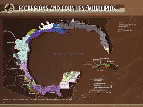
ECOREGIONS AND COUNTIES/MUNICIPIOS Mississippi Alabama Louisiana
*Please See Ecoregions Unit on pages 19–20 for Map Legend
Georgia
Coastal Belt
Texas
Coahuila
Florida
Nuevo León
GULF OF MEXICO Mayabeque La Habana Matanzas Artemisa Pinar del Río
Tamaulipas
San Luis Potosí Yucatán
Hidalgo
Quintana Roo
International Boundaries
Tlaxcala Puebla
Veracruz
Oaxaca
Tabasco
State/Province Borders
Campeche
Chiapas
Sources: U.S. Census/TIGER (2010); INEGI (2010); ONE (2010); ESRI (2008); NationalAtlas.gov (2004); TNC (2009)
N
Counties/Municipios Boundaries
0
200
400 Km
Sources: U.S. Census/TIGER, 2010; INEGI, 2010; El Sistema de la Oficina Nacional de Estadísticas (ONE), 2010; NationalAtlas.gov, 2004; The Nature Conservancy, 2009; ESRI, 2008; USGS, ESRI, TANA, AND, 2009;
43


