

A WISH FOR A WASTE FREE WORLD... A PROTOTYPE FOR A ZERO-WASTE NEIGHBOURHOOD
Introduction:
This project has several scales to it, therefore this technology report has been separated into sections, based on which scale is being addressed. Most of the proposal will be at building-scale, however as this project addresses wider issues and the proposal is for a Zero-Waste Neighbourhood, it is important to find understand the wider context and the strategies applied at neighbourhood scale. Therefore the report is divided into these sections:
1. Executive Summary - an overview of the proposal
2. System Change - creating a Zero-Waste Neighbourhood strategy
3. Neighbourhood scale - applying the neighbourhood strategy to Barton-le-Clay
4. Site Scale - the selected site containing the new Village Hub and a Zero-Waste Housing scheme.
5. Village Hub - centred around waste. A brief section discussing its retrofit strategy.
6. Zero-Waste Housing - a more detailed investigation into whether a zero-waste house is possible. Proposing an alternative model to the current housing developments whilst also applying it specifically to the site in Barton-leClay.


SITE SCALE


EXECUTIVE SUMMARY: THE ISSUE
Society currently lives in a culture of take, make, and throw away. For a more sustainable and resilient future, we need to mimic nature and remove waste from the system – a true circular economy. This is not just about the circularity of resources, but is centred on changing people’s mindsets and behaviours.
This proposal primarily focuses on reducing these key forms of waste generated in the UK:
• Household waste (investigated on the right)
• Waste from the construction industry
VISIBLE WASTE AUDIT; ONE WEEK
Not including food waste (goes to compost)
WASTE IN THE HOME; BOTH VISIBLE & HIDDEN
THE PROBLEM
These waste streams not only include physical waste but also hidden waste, such as energy wasted or pollutants.


Construction, demolition and excavation (CD&E; including dredging) generated around three fifths (62%) of total UK waste in 2018.
Food packaging
crazy house prices, poor renting options, social renting stigmatised, etc...
piles of waste, pollution, etc..
SOME STATISTICS
EXECUTIVE SUMMARY: NEIGHBOURHOOD SCALE
A Zero-Waste Neighbourhood is a proposal applied at neighbourhood scale, as this offers the most impact and opportunity for success. The strategies for a Zero Waste Neighbourhood have to be applied site specifically, so neighbourhoods were grouped into different typologies, ranging between rural and urban. This is discussed in more detail in the System Change section of this report.
The typology of neighbourhood was selected which had the most potential for change:
• Semi-rural/suburban
• Car-centric and commuter
• Expansion in motion (housing developments)
BARTON-LE-CLAY
Barton-le-Clay was chosen as the example neighbourhood where the proposal could be applied.
Features:
• A suburban/semi-rural large village, 20 mins drive north of Luton, making it in both Luton's and London's commuter belts.
• Its large enough to have some infrastructure and a high street.
• A very car-centric village even though it has an active high street.
• Heavily owner occupied and has a large housing development of 500 homes on its way, objected by local residents.
• Currently in the process of writing their neighbourhood plan - by implementing zerowaste as their overarching neighbourhood strategy, they can reduce waste & reap the benefits whilst also creating climate resilience (& people resilience eg stopping people moving away).
The neighbourhood proposal is discussed within the 'Neighbourhood Scale' section of this report.

map

Proposed neighbourhood map of Barton-le-Clay: SITE
The chosen site for detailed design was Bartonle-Clay's existing Village Hall and surrounding buildings and allotments. This is explained in detail in the 'Site' section of this report. There are two main parts to the proposal:
1. THE VILLAGE HUB
Expanding the location of the village hall into a village hub, centring around 'waste'. The site includes:
• Waste center
• Workshops
• Food Hall
• Market
• Allotments, for community growing and educating people on a sustainable way of life.
•
2. ZERO-WASTE HOUSING
The other part of the site contains new housing built with a waste-free building strategy, that also lets residents live waste free. This includes:
• Zero-Waste House: Built as terraces, they aim to produce no waste either in construction or in use. This is investigated in detail in the Zero Waste Housing section of the report. Design features include a sunspace for growing food and passive solar gain, as well as storage systems instead of bins.
• The Common House: Part of living sustainably is sharing resources, which also boots community. This house contains many shared spaces including: a shared kitchen & living space, a gym, a workshop, a laundry room, a cinema room, bathrooms, and finally bedrooms so visitors have a place to stay, reducing the need for residents of the housing scheme to have spare bedrooms.
• Shared external spaces, including allotments, wildflower meadows, ponds, play areas, bike shelters and gathering spaces, all to enhance community and quality of life.
The overall site is discussed within the 'Site Scale' section of this report.

ZERO-WASTE HOUSING
EXECUTIVE SUMMARY: THE VILLAGE HUB
The Village Hub includes:
WASTE CENTRE
Focusing on resource exchange, where 'waste' from local residents gets collected, sorted, stored and resold or traded. This becomes the new hear of the community.
WORKSHOPS
Where material from the waste centre as well as other local waste or natural materials gets creatively reused. The workshops aim to give people activities to do and learn new skills, as well as teaching how to live sustainability.
FOOD HALL
A new and expanded Village Hall, centred around local food and community. These closely located to the allotments to give a farm-to-fork connection.
MARKET
To support local businesses boosting the local economy, whilst encouraging a more sustainable, healthy and local buying of produce.
ALLOTMENTS
For community growing and educating people on a sustainable way of life.
THE SCHEME
The terrace is designed to incorporate a common house in each scheme, providing shared resources such as utility rooms for laundry and tool sheds, while fostering a sense of community. This reduces resources and impact per dwelling. Various other features are included within the scheme, such as:
Carpool
So residents don't have to own their own car, and reducing journeys by car.
Shared growing space
As well as individual space for growing outside their homes, there are communal allotments, encouraging self sufficiency, connected with nature, and community.
Play areas, for both adults and children. Including landscaping features that children like to play on, as well as specific playground items.
Diverse surrounding habitats including SUDs. Adding diversity not only increases the resiliency of the land but improves the health & happiness of residents.
DENSITY
The terraces are relatively short in keeping with the site and density of the suburban typology, yet offering more communal outside space. Applying this model to more urban densities would allow for longer terraces.
Typical density of suburban housing = 35-50dph Barton-le-clay = between 20-30dph.
Zero-Waste Housing scheme = ~30pdh
The Zero-Waste Housing model applied site specifically to the chosen site within Barton-le-Clay

EXECUTIVE SUMMARY: ZERO-WASTE HOUSING
THE TERRACE MODEL
Mainstream construction is wasteful and energy-intensive, not just in their construction but also when buildings are in operation. This terrace model has been developed to provide an alternative, whilst keeping some of the qualities that people ensure & fitting with the general UK vernacular.
Though in this report the housing model has been applied site-specifically, the idea is that it can be used and adapted across the UK.
Design considerations include:
• Healthy home (natural materials / no VOCs).
• Maximise passive systems.
• Minimise energy loss through building fabric.
• Maximise efficiency of services & systems.
• Construction process with minimal waste.
• Storage solution instead of bins
• Encouraging sharing of resources (through cohousing / community resource options)
FEATURES:
Loft conversion potential

Small axonometric of the terrace as one dwelling, but can be adapted to two dwellings in the future.
Balcony
• Allow south-facing outside space for upstairs dwelling.
• Prevents overheating of sunspace
South-facing growing garden:
• Increase self-sufficiency
• Understanding of where food comes from
• Health & wellbeing benefits
Sunspace
• Increase self-sufficiency
• Can grow more food that requires a different environment to outside
• Thermal mass and passive solar gain enable some natural heating within the home
• Inside-outside space that encourages more outside living & connection to nature
TYPOLOGY 1: One dwelling per terrace.
Resident type:
• Young couple looking to expand their family.
• Larger multigenerational families.
Housing requirements: Potential to stay in the house for a long time with maximum adaptability, including adaptable rooms, loft conversion potential, and lots of storage.
• A key part that makes a terrace house so adaptable is the option to extend both horizontally and vertically. The loft can be used as storage, or it can be converted for either an expanding family, or for when the house is split into two.
Resource storage system
• Instead of bins, resources no longer wanted can be stored in an easy environment that incentivises residents and so the resources can be reused at the Village Hub.

Kitchen/Living
• Kitchen next to sunspace with sliding windows for farm-to-fork connection.
• Open plan for fluidity and openness between spaces and adaptability - walls can be added if needed.
• Ground floor ensures a through-flow between outside to inside to outside again.
TYPOLOGY 2/3: Two dwellings per terrace.
Resident type:
• Older person looking to downsize (ground floor) AND
• Young person/ couple looking to move out from home
Housing requirements: Part M requirements on the ground floor including bedroom. Upstairs still needs outdoor space & potential for expansion.


THE FIVE PRINCIPLES OF A WASTE-FREE WORLD
fundamentals A
In order to transform our current way of living to one that is waste-free, there are five key principles we need to follow:
1. RESPONSIBILITY for our actions
We need to accept our responsibility of the destruction of our environment & our __ for climate change, before we can begin to change.
2. RESPECT for people and planet
Without respect, we will consistently believe humans are above all else - and certain humans are above others. This lack of respect and overpowering greed is causing the destruction of the environment but also other issues (eg colonialism). These issues are all connected. We need to hold all humans as equals & the planet too.
3. REIMAGINE our society
Currently our capitalist society puts profit before people, valuing individuality over community and consumerism at its centre. This means people don't share resources & constantly buy cheap, leading to increasing use of resources. To create a less individualistic society, a society around a sharing & circular economy to prevent destruction of the planet, we need to re-imagine something better. Without belief, it doesn't happen.
4. REGENERATE our environment
We are already well on our way to the total destruction of our environment. We need to restore & regenerate our environment so the planet can heal & we can live harmoniously with it.
5. RETHINK our economy
Behaviour change is the key to transformation. An expansion of the reduce-reuse-recycle, everyone must go through a 9-step process to reduce our consumption & decrease our use of resources.
1. refuse what we don't need
2. reduce what we do need
3. re-use what we have
4. repair
5. rethink
6. regift
7. recycle
8. rot
9. recover the rest to extend its life to give it new life


An earlier development of the steps required for rethinking our economy.
ZERO-WASTE NEIGHBOURHOOD fundamentals A
The neighbourhood scale is the most impactful because a zero-waste holistic strategy needs to be localised enough to interact with people & communities to enact behaviour change, whilst working with larger systems to create transformation at scale. This can be applied anywhere, though it will be demonstrated later in this report how these strategies have been applied site-specifically. Strategies at this scale include:
1. LOCAL FOOD TRADE NETWORK
Localising food produce with renerative agricultural practices boost local economies and reduces food waste and packaging waste. Food waste accounted for nearly 50% of CO2e generated from solid waste treatment in 2016 (Kaza et al., 2018).
2. RESILIENCE WITH COMMUNITY OWNERSHIP
Resilience leads to less impact from disasters, therefore creating less waste and need for replacement resources. Community ownership gives power to local communities who know their own environments best & ownership ensures they are likely to care for them.
3. SPECIES-RICH ENVIRONMENTS
Regenerating our environment and increasing biodiversity, this creates resilience against climate or biodiversity related disasters.
4. ZERO-WASTE HOUSING
New building strategy, particularly for any new housing. Current housing production is extremely wasteful and this provides an alternative, both during the design/construction process and after.
5. NEW VILLAGE HUB AROUND ‘WASTE’
Overlooked benefits of exchange - resources, education, etc. Expanding on the current typology of the village hall, creating a village hub that centers 'waste' through resource exchange, knowledge sharing, and creative re-use of materials.
6. LOCAL SYSTEMS & SERVICES
Decentralised, local systems means creates resiliance against disasters that affect the economy, plus they also require less energy used in transport. It also has benefits for the local community.
7. WALKABLE NEIGHBOURHOODS
Putting humans first before cars. Includes green infrastructure such as cycling networks and public transport. Also includes car-sharing.
8. ZERO-WASTE INCENTIVES & A SHARING ECONOMY
Unfortunately transformation cannot happen without the help from zero-waste incentives that help to create change. This will lead us towards a circular, sharing economy that reduces the amount of resources we need.


LOCAL FOOD TRADE NETWORK
RESILIANCE WITH COMMUNITY OWNERSHIP
SPECIES-RICH ENVIRONMENTS
ZERO-WASTE HOUSING

NEW VILLAGE HUB AROUND ‘WASTE’ LOCAL SYSTEMS & SERVICES WALKABLE NEIGHBOURHOODS
ZERO-WASTE INCENTIVES & POLICY
fundamentals A
Neighbourhood scale is the most impactful to work at, but it must fit within a wider initiative of zero-waste incentives and initiatives to create transformational, wide-scale change.
MACRO - UK-WIDE
UK-wide initiatives and incentives enforce rules that can help with change on a wider-scale, only if there is also work being done in communities.
MACRO/MESO - LOCAL PLAN
Local plans are important for incentivising change by creating regional strategies, especially for the circular economy through resource and material strategies that are more efficient on a wider scale. For example,
Local Plans are also responsible for most planning problems, including building homes, public services, commercial buildings and associated infrastructure (The importance of having a Local Plan, 2021). Therefore the ZeroWaste Neighbourhood holistic strategy must be integrated at this level to have a wider vision and connect with UK-wide strategies.
However, this scale with councils having too much power and not enough in the hands of communities, plays a part in the reason housing is unfit for purpose, non-integrated and all looks the same.
MESO - NEIGHBOURHOOD PLAN
Therefore, the most power should be given to the Neighbourhood Plan to enact change. Neighbourhoods plans are written with a 50/50 mix of people from the local council and local residents. This gives ownership and power to the local community, who will also know what's best for the area. This ensures strategies are applied site specifically and homes built are fit for purpose and integrated into the community.


A neighbourhood plan can only exist within a Local Plan (The importance of having a Local Plan, 2021).
The key focus of this proposal - creating a Zero-Waste Neighbourhood strategy,
MESO/ MACRO
MACRO
MESO
A ZERO-WASTE LENS ON POLICY, FRAMEWORKS & STANDARDS
environmental assessment A
Using a zero-waste umbrella, which are the best frameworks, benchmarks and tools to use to encompass a holistic zero-waste strategy? The ones chosen to analyse are the most relevant to encompass a holistic zero-waste strategy, Some are very broad in scope, some are more technical, and some apply to only specific buildings. The ones highlighted are the ones that best fit into a holistic zero-waste strategy, though none directly address the benefit of looking through a zero-waste lens to encompass & address all issues & targets.
NOTE: any kind of certification cannot fully codify the soul of a space or neighbourhood.
CONSIDERATIONS:
• Many frameworks & standards partially & indirectly influence waste streams, eg by increasing the durability of buildings, but none address the issue head-on and therefore prevent a transformative response to the issue(s?).
• There are lots of targets, but most don't even mention the necessary behaviour change that is at the heart of changing wasteful habits.


FRAMEWORK DESCRIPTION
Building Regulations Approved Documents
National Design Guide
• Guidance on how to meet the building regulations, which are legal requirements to ensure the safety of human lives.
Many categories related to building works (eg fire, structure, ventilation, overheating, access, stairs)
• Beginning to address wasted heat and energy through increased U-values.
• Waste requirements for water and sewage although extremely traditional in nature.
• Many documents address longevity & durability of buildings, aiming to increase their lifespan (less materials used).
• Difficult to build on green-belt land, which is good for maintaining our natural environment & reducing sprawl, indirectly meaning less waste.
• No real requirements for waste. This could be particularly transformative if they addressed construction waste or circular systems for water/excretion/energy generation. Legal requirements for all buildings. Both
Central Bedfordshire Local Plan
(Central Bedfordshire Council, 2021)
• Guidance only, no legal requirements.
• Released by the government to demonstrate how to achieve welldesigned places
• To help Local Authorities achieve high quality design, and also prepare their own design guides.
• 10 characteristics for well-designed places.
• Councils are required by law to produce a Local Plan, which are supposed to be reviewed and updated every 5 years.
• The key challenge this Plan addresses is establishing "where these unmet housing needs can be accommodated sustainably, whilst also meeting our own objectively assessed housing need"
(Central Bedfordshire Council, 2021, p.17)
Context, Identity, Built Form, Movement, Nature, Public Spaces, Uses, Homes & Buildings, Resources, Lifespan
• Section dedicated to conserving natural resources including land, water, energy, materials
• Recognises the impact other factors have on reducing energy (eg active travel / infrastructure)
• Considers water management, using the water instead of directing it away as 'waste'. Includes SUDs which will reduces flood risk, increases durability of buildings (reducing materials required over time).
• Considers high quality green spaces including food production, which can begin to encourage resource sharing.
• Barely mentions circular economy and materials
• No mention of community and human benefits of resource sharing & community recycling.
• As a government issued design guide, it fails to introduce zero-waste concepts to a UK-wide audience, which could be transformative. Can be used at any scale, but works well at larger scale as it considers neighbourhood energy schemes & infrastructure. Not specific but no mention of retrofit or its benefits.
Six main themes: Local character, Environment, Transport, Jobs & Business, Growth & Infrastructure, Homes.
• The only site-specific document, collecting, analysing and applying local data. This gives a key snapshot into what the area has and requires. When applying any framework, one should first refer to this document to ensure any improvements are applied appropriately.
• Instead of having a fragmented approach to each site or neighbourhood, a Local Plan gives a holistic approach across the entirety of a city or borough. A neighbourhood plan can then be written that works together with the Local Plan. Without a Local Plan communities can struggle to make their voices heard in planning decisions that affect their areas.
• Recognises & addresses the importance of working at larger-scale, including creating high quality neighbourhoods that don't just focus on new developments, but also green infrastructure, community, education etc.
• A holistic overview with detailed planning which helps to ensure projects are worthwhile and resilient.
• The consultation process for a Local Plan gives communities a voice, ensuring happier & healthier and therefore more resilient communities.
• Works to protect green-belt land and mitigate against climate change (the outcome of this is arguable).
• Working at a Local Authority scale, this would be the most effective document to apply zero-waste incentives and systems that are best run at this scale (e.g. a circular waste strategy with refuse & recycling centers, a circular materials strategy, etc...).
• Centered around planning and growth, so lacks any strategy for existing buildings such as retrofitting the existing housing stock or specific targets for using our existing buildings first.
• Missed opportunity to mention the wasteful construction process new-build developments create, and a implement a circular strategy that could reduce waste and also transform local industry.
Is written at scale. Focuses on new-build, no plan for retrofit (no plan UKwide)
10 characteristics of a well-designed place (Ministry of Housing, Communities & Local Government, 2021)
Front page of Central Bedfordshire Local Plan 2015-2035 (Central Bedfordshire Council, 2021)
A ZERO-WASTE LENS ON POLICY, FRAMEWORKS & STANDARDS
environmental assessment A
FRAMEWORK DESCRIPTION
UN Sustainability Goals
• A worldwide, general "blueprint for peace and prosperity for people and the planet, now and into the future" (UN Department of Economic and Social Affairs, no date)
CATEGORIES / FEATURES?
17 goals addressing all aspects of life.
One Planet Living
Living Community Challenge (LCC)
• A broad, holistic framework set-up to align with the UN sustainability goals, that works directly with different groups of people.
• Sectors include One Planet for: local governments, companies & NGOs, community groups, networks, and young leaders.
• A comprehensive holistic framework for master-planning for communities, a scaled-up version of the Living Building Challenge (LBC).
• About creating regenerative projects, more than just mitigating the negative impacts that come with building.
• Different pathways to certification, including wholly certified, Petal certified (only 3 categories), and a Zero Energy Community certification.
• One of the only certifications that focus on specifically the community.
Health and happiness, Equity and local economy, Culture and community, Land and nature, Sustainable water, Local and sustainable food, Materials and products, Travel and transport, Zero waste, Zero carbon energy
Place, Water, Energy, Health & Happiness. Materials, Equity, Beauty
TO WASTE/ CIRCULAR
• Goal 12 - ensure sustainable consumption & production patternsdirectly considers waste & circular economy.
• Goal 11 - sustainable cities & communities - considers importance of waste management, as well as community planning & infrastructure, incentivising less private ownership and
• Addresses zero-waste, including recognising the problem from consumerism.
• Recognises indirect waste streams and takes a holistic approach to remedying eg infrastructure such as low-carbon transport and encouraging active travel.
• The policies are very broad without specific metrics, unless measured per GDP which is country-scale rather than local scale.
• Does not directly incentivise local scale which has a massive impact on waste as well as the other goals.
Only at very large scales ie. countrywide N/A
One Planet Development (OPD)
• A progressive planning policy to provide a sustainable way for people to live & work on their own land, adopted by the Welsh government.
• Quantified by an ecological footprint, showing how much of the Earth's resources are being consumed.
Structured as a management plan
Elements within: Land based activity, Land management, Energy & Water, Waste, Buildings, Community Impact, Transport and Ecological Footprint Analysis
• Recognises that the ideal scale for solutions may differ & therefore allows 'scale-jumping' to accommodate communities of varying sizes to operate in a cooperative state eg. sharing infrastructure for maximum efficiency
• Focus on materials including responsible & local sourcing, as well as offsetting embodied carbon through responsible means.
• Net-positive waste imperative within materials reducing waste at all stages - design, construction, operation and end-of-life.
• Shared infrastructure is common.
• Projects must integrate opportunities for agriculture, meaning more localised food production & less waste from packaging.
• By encouraging public/active transport, it reduces the need for individually owned cars, meaning less waste & pollution.
• Though it says energy & water must be dealt with within the project, dealing with these at a larger scale is allowed (called 'scale-jumping'), making the standard more UK suitable.
• Requires community initiatives which encourage shared ownership, reducing waste
• Resilience strategies mean environments will last longer, reducing waste & need for resources.
• Includes maximum sizes for homes & buildings, reducing resources needed for construction.
• Recognises the limitations of achieving the ideal, particularly in attitudes (competition/privatisation/consumer/etc.) For example, with materials, the market needing honest information sharing instead of manufacturers hiding their 'trade secrets' for competitive advantage.
• Dedicated section on waste, minimising then assimilating all waste on site through recycling, re-use and composting.
• Considers timber grown on site for fuel or a construction material as a positive impact, meaning potentially minimised carbon due to transport.
• About living sustainably, not just sustainable buildings, which will creating behaviour changes much more effective at reducing waste.
• Buildings must be low carbon, with zero-carbon analysis looking at both embodied and in-use, meaning reduced material resources & less energy wasted
• Must produce >30% food on site, meaning local food production & less packaging. This is incentivised by a moderate cash-income that must happen once project is established.
• Use of low-carbon transport
• Must recycling & compost organic material, reducing waste.
• No specific targets, making it harder to commit to any outcomes. Set up for any scale. N/A
• Too focused on community-scale, not always addressing the benefits for larger-scale where applicable:
• Scale-jumping is not extensive enough for UK-based projects (much smaller country with more networks & higher densities, meaning more potential in shared networks). For example - projects must process their own waste but scale-jumping does not apply here. Waste is almost always managed by councils.
• Only considers construction waste, does not consider waste from occupants (& behaviour)
• Uncertain imperatives in regard to expanding existing settlements into agricultural land allowed.
• Only been done in America, and very few precedents at that. Furthermore the program is no longer taking registrations, suggesting it was unsuccessful to implement - potentially too difficult & requires large organisation eg from governments)
The original Living Building Challenge is for single sites only, however the newer Living Community Challenge was created exactly for this purpose. The standard follows the New Urbanism Transect model for rural to urban categorisation, making it beneficial for different sized communities.
Lacking mention
• Almost all waste must be assimilated on site, which is harder to control on large, community scale sites that have constant visitors.
• Refers only to rural developments of different sizes, suburban or urban landscapes are not considered.
Scalable - scale can range from single homes to co-operative communities to larger settlements. Only for rural housing. No specific consideration to retrofit.
A ZERO-WASTE LENS ON POLICY, FRAMEWORKS & STANDARDS
environmental assessment A
FRAMEWORK DESCRIPTION
Passivhaus / Enerphit
• A rigorous standard for energy, comfort & building quality, focusing on decreasing operational carbon.
• Passivhaus is the standard for new builds. Enerphit is the standard for retrofit, recognising the difficulties associated with retrofitting so the requirements are not as strict (eg U-values).
• To achieve certification, the project must be signed off by an independent accredited Passivhaus Certifier.
LETI Climate Emergency Design Guide / Retrofit Guide
• Comprehensive yet holistic guide to reducing the carbon emissions of buildings, one guide for new buildings and one for retrofit.
• Has a step-by-step plan with specific targets to reach
CATEGORIES / FEATURES?
Five main principles - thermal insulation, windows, ventilation heat recovery, airtightness and absence of thermal bridges (Passivhaus Institut, no date). TOOL: PHPP
New buildings: 5 key areas
= Operational energy, embodied carbon, the future of heat, demand response and data disclosure. Four key building archetypes with targets for each.
• Robust on-site verification meaning high-quality construction, lowering the performance gap & increasing the lifespan of the building.
• Decreases the operational carbon of the building by maximising efficiency of services through eg thick insulation. This means less energy is wasted.
Active House (Active House, 2020)
• Focuses on the user & a beneficial indoor environment.
• All criteria has both quantitative and qualitative (softer) aspects. The qualitative aspects require you to put an argument forward explaining how you meet that requirement.
• The quantitative data has four levels 1-4, with 1 the most stringent.
Three primary principles - comfort, energy, environment
• Addresses waste from energy and materials through the lens of carbon emissions, looking at both embodied carbon (materials focus) and operational carbon (energy focus).
• Recognises different abilities/requirements of different typologiese.g. small scale vs. large scale housing
• Recognises benefits of neighbourhood-scale such as with energy generation e.g. district heat networks.
• One of the only documents to directly point out the importance of behaviour change, with suggestions on how to tackle this within buildings.
• Stresses the importance of monitoring and data collection.
• Addresses different types of retrofit, including recognising some of the difficulties older houses propose, allowing them more flexible targets.
• Directly addresses occupant behaviour for correct building management & general education, which directly correlates to the longevity of buildings & a healthier indoor environment.
• Addresses the parts of living that can't be quantified, which plays a large part in humans and the way they live - i.e. behaviour - the key to transforming to a zero-waste lifestyle.
• Requires a yearly performance check of the building and systems - this ensures everything is working and therefore increasing the durability of the building.
• Currently no specifics in relation to physical waste, which would be easy to implement into the on-site verification process.
• Lack of recognition to embodied carbon - materials are unspecified. meaning lineareconomy materials such as petrochemical insulation can be used. requiring more energy and releasing carbon & other harmful gases, and at end-of-life creates physical waste as they cannot be recycled.
Each building requires certification.
WELL
• Focused exclusively on occupant health & well-being. Each feature is either performance-based or descriptive. Certification comes from the submission of documentation and an on-site audit, resulting in an award between Silver, Gold or Platinum. Air, Water, Nourishment, Light, Fitness, Comfort, Mind
The WELL and BREEAM have an alignment, making it easier to conform to both.
• Considers quality of water & food as well as responsible food production.
• Considers pollution from materials & construction in air category.
• Materials used are more likely to be natural & non-toxic ie. less polluting.
• Occupants in this environment are likely to be happier, leading to more ownership & care for the environment, indirectly leading to less waste.
• Extensive focus on air & comfort means buildings should be designed well, making them last longer, decreasing waste of materials.
• No specific targets for wider scale options, such as neighbourhood energy generation, even if it considers it within the document.
• Retrofit targets address existing homes only.
• On a building by building basis, does not look at the wider scale.
• Does not directly address refuse (physical waste) from construction or those living in it.
Yes - but targets are applied to each building.
• No consideration to the potential of wider scale - such as district heat networks for diversion of waste energy instead of energy generation. Each building requires certification.
Both (a different standard for each).
BREEAM
• Most established & recognised method in the UK. Has a suite of validation/ certification systems covering a range of projects.
• Ratings start from unclassified (<30%), to excellent (>85%) or outstanding (>90%).
• The certificate & rating is awarded in a post-construction assessment.
• Categories are weighted based on their environmental impact, with a minimum score for each to achieve certification.
Many standards including: new construction, refurbishment & fit-out, in-use, communities. and infrastructure. General criteria: Energy, Land use & ecology, Water, Health & wellbeing, Pollution, Transport, Materials, Waste, Management, (& Innovation).
• The only in-use standard with a categories addressing waste - physical & non-physical/unwanted (pollution).
• Considers efficient building services & plumbing systems, reducing waste in energy, water and materials for constructing these services.
• By encouraging public/active transport, it reduces the need for individually owned cars, meaning less waste & pollution.
• Considers renewable energy, reducing waste in the unwanted senseie reducing unwanted gases in our atmosphere.
• BREEAM Communities requires alignment with strategic plans set out by local authorities, making it very suitable for neighbourhood-scale strategies in the UK.
• BREEAM Communities credits can be used for building level assessment.
• Recognises importance of community management & control over facilities.
• No consideration of energy-use and very little on construction, structure or materials.
• Does not consider the wider human/ environmental impact of using unnatural materials
• Targeted at commercial buildings.
• Only considered individual buildings, waste systems work best if considered holistically at a larger scale.
• Higher capital cost for building to reach the required standard. This is not useful for community-run projects.
• Potentially overly complicated, particularly all the different standards for different types of project. BREEAM advisors required.
• By trying to make the process less complicated, BREEAM Communities have moved away from assessment criteria based on regional & national policy.
• Set up for single structures, not at masterplan scale.
• Only suitable for residential if multifamily with a shared structure.
Targets for both (but retrofit for homes only).
New-builds only.
• A community pilot is in development. Can be applied to both new and existing buildings and interiors.
Yes, BREEAM Communities credits can be used for building level assessment too.
Yes but different standards for each.
ZERO-WASTE NEIGHBOURHOOD FRAMEWORK
environmental assessment B&C
KEY DRIVER OVERVIEW & CONSIDERATIONS CATEGORIES TARGETS -
NEIGHBOURHOOD SCALE
DESIGN WITH THE ENVIRONMENT

Working with the environment first is key to producing sensitive buildings that remain low-impact on the environment. It will also produce site-sensitive designs that fit well with the surroundings.
• Retrofit first, then low-quality brownfield / greenfield land
• Biodiversity net-gain (more if on greenfield land)
• Design with the environment: work with terrains, enhancing passive systems, prevent surface run-off
Land-use & biodiversity
Opportunities integrated for agriculture appropriate to scale/density of the community (using the Floor Area Ratio (FAR) as basis for calculation)
Energy (use & generation)
Water
105% of community’s energy needs must be supplied by Community-generated renewable energy on a net annual basis, including all energy for water & waste conveyance. [can be scaled] LCC
100% community's water needs supplied by natural closed loop water systems and/or recycling used community water.
Flood risk assessment & commitment to recommendations by advisory bodies.
BREEAM Communities
Resilience & Adaptation
A CIRCULAR MATERIAL-LED APPROACH

Working with the technical and biological cycles, whilst also boosting local economies & decentralised systems, improving resilience.
Materials
• Reclaimed materials from site where possible (eg any excavation)
• Natural materials prioritised
• Responsibly sourced, second-hand
• On site / local materials & products
• No petrochemical unless necessary & reusable (eg services)
• Circular services eg water
Materials & resources
Community must create a Material Conservation Management Plan to minimise waste across all projects' lifespans - through the design, construction, operation and endof-life stages.
Community must divert wasted materials:
• >99% for metal, paper/ cardboard, soil & biomass
• >95% rigid foam, carpet & insulation
• >90% all others
Diversify land use with at least part in ownership by the community. Own target.
Ecological assessment & strategy by qualified specialist.
Heating & hot water generation is fossil-fuel-free
0% impervious parking surfaces.
All stormwater & water discharge (grey/black) must be treated and managed at community scale unless more efficient at larger scale.
Adapted from LCC
All sensitive infrastructures are out of the flood plain.
The targets outlined will be examined in greater detail in this report.
SITE/BUILDING SCALE
Projects must be built on greyfield or brownfield land. Building on greenfield sites is allowed if:
• existing low-quality greenfield land
• improving the quality of the greenfield land
• project permanently conserves 2x amount land on/adjacent to community, and improving the quality of the existing land Adapted from LCC.
Maximise renewable energy generation on site where more beneficial than district network, without sacrificing key spaces for people & animals.
Adapted from LBC.
Reduce demand by increasing passive systems
Own target.
Water saving & recycling strategies (eg grey water used)
Active House
Community must develop an implementation plan to ensure all community facilities, common infrastructure and landscapes must follow LBC imperatives I10-13.
LCC
Dedicated infrastructure for the collection of recyclables & compostable food scraps throughout the community.
0% construction waste to landfill
Resilience & Adaptation (supporting local businesses)
Food composting compulsory & must be reused within the community.
A local materials strategy & a regional materials strategy. Own target.
Create less reliance on mechanical systems & reduce energy demand by increasing passive systems. Own target.
Minimise surface water runoff & control stormwater runoffrainwater prevented entering sewage systems. Active House
70% by weight of building can be reused, recycled or backfilled at its end of life. European Directive on construction & demolition waste, taken from Active House.
Building finishes must come from regional or local materials. At least part must come from within neighbourhood boundary. Own target.
is
Each building provides recycling & composting infrastructure for occupancy.
Yearly performance check of building & systems.
Decentralised power grid founded on renewable energy.
Ensure each development
resilient to known & predicted impacts of climate change (e.g. flood risk). BREEAM Communities
Local energy storage. LCC
75% materials must be sourced from the UK LBC
90% of building cannot be made from red-list materials.
>10% biodiversity net gain. Natural England
In new homes, must provide space & the infrastructure required to produce >30% food on-site. Adapted from OPD.
Active House
ZERO-WASTE NEIGHBOURHOOD FRAMEWORK
environmental assessment B&C
KEY DRIVER OVERVIEW & CONSIDERATIONS CATEGORIES TARGETS
-
NEIGHBOURHOOD SCALE
DESIGN FOR THE FUTURE Buildings should be built to last ~200 years (Dark Matter Labs, 2023)

Adaptability & education for futureproofing is key! Understanding of the environment and buildings leading to behaviour change & increasing their durability.
• Design for deconstruction, recovery and reuse
• Design to adequate quality (eg Passivhaus accreditation)
• Healthy buildings (eg active house / WELL standard..)
• Design for adaptability & future changes of use or spaces
Developments:
• Ground floor in homes built to Part M to allow for future adaptations
Construction & end-of-life
Health & happiness
Quality Control Checks done on-site throughout the construction process, to ensure the building is built as designed. Passivhaus
Ensure essential facilities are provided within a reasonable and safe walking distance from majority of homes.
Adapted from BREEAM Communities
Resilience & Adaptation
MAXIMISE EFFICIENCY & MINIMISE WASTE

A mix between reducing demand and maximising use of resources. To minimise waste this usually requires neighbourhood scale planning. To maximise efficiency this is generally applied per building.
• Minimise requirement & maximise efficiency through insulation
• Maximise passive energy (less need for ‘products’ e.g. PV panels)
• High-quality services
• Common grid (600x600mm) for easy availability of products
• Any ‘waste’ to be responsibly returned to resource streams
• Built in waste systems / wasteprevention features
Developments:
• Design housing to be terraced unless good reason
• Smaller spaces mean less materials; utilise outside & shared spaces instead.
& end-of-life
Interpretive signage that teaches visitors and occupants about the Community and its environmental goals and features.
LCC
An educational website & brochure that shares information about the design and operation of the Community.
LCC
District heat networks must be set-up for both new-build and retrofitted homes in order to use previously wasted heat from non-domestic buildings. Own target.
Operations and maintenance manuals for all Community infrastructure. LCC
Allow for future growth in services.
BREEAM Communities
Training of building users.
Active House
Retrofit plan for all homes in neighbourhood, and all 'waste' materials (e.g. single-glazed windows) collected & re-used in new-builds and/or community projects.
Own target.
Embodied carbon impact from construction of neighbourhood infrastructure & community facilities must be off-set within the project boundary (can include surplus energy generated), keeping benefits within the neighbourhood. LCC
Assessment of any existing buildings and infrastructure is carried out to determine what can be refurbished, reused, recycled or maintained and those of significant value.
BREEAM Communities
The targets outlined will be examined in greater detail in this report.
SITE/BUILDING SCALE
On-site control focused on proving that the energy solutions and products meet the designed level.
Active House
In housing developments different tenures are distributed & integrated with each other to reduce the impact of housing type/tenure on social division.
BREEAM Communities
Provide a comfortable outdoor environment through the control of climatic conditions on a micro scale e.g. protection from sun/wind/rain. BREEAM Communities
Design ground floors in homes to Part M to allow for future adaptations. Own target & Approved Doc M
Use of smart meters & provide visual energy display device to raise awareness and make users responsible for their energy consumption.
LETI
Space heating demand:
New-builds = 15 kWh/m2/yr
TOOL: Design PH/PHVP
U-values:
New-builds = <0.15 W/(m2K)
Retrofit EWI = <0.15 W/(m2K)
Retrofit IWI = < 0.35 W/(m2K) Passivhaus/EnerpHit
Neighbourhood net-zero strategy (shared carbon within the neighbourhood boundary). Own target.
Justification for demolition of any existing buildings/ infrastructure.
BREEAM Communities
Domestic embodied carbon <300kgCO2/m2 LETI (best practice 2030)
TOOL: Manual life-cycle analysis with EPDs and ICE database
Design to Approved Docs particularly Doc B for fire safety. Approved Doc B
Continous monitoring & reported data with real-world energy performance evaluation. LETI and Active House
Limit peak heat loss for heating to 10W/m2 (including ventilation). LETI
Thermal bridges taken into account when calculating U-values. Passivhaus
Reduce energy consumption to <35 kWh/m2.yr. (Energy use intensity in GIA, excluding renewable energy contribution). Active House, adapted.
MVHR to minimise heat loss in winter months. Units should have a heat recovery efficiency of ≥ 75%.
Adapted from Passivhaus.
All new-builds are net-zero-carbon. LETI
Thermal bridging minimised & evaluated during the construction process. Active House, adapted.
ZERO-WASTE NEIGHBOURHOOD FRAMEWORK
environmental assessment B&C
KEY DRIVER OVERVIEW & CONSIDERATIONS CATEGORIES TARGETS -
NEIGHBOURHOOD SCALE
CELEBRATE PEOPLE, CELEBRATE LOCAL

In order to prevent these 'copy & paste' developments, that not only look the same wherever you are but are car-centric and profit driven, you must put people & local heritage (to celebrate local culture and history) as a key driver. This includes:
• Infrastructure first, development second
• Human-scale people-powered infrastructure, group travel over individual
• Always keep & celebrate as much of existing as possible
• Design with flexible spaces that allows for adaptability
• Include exposed local materials to celebrate place/heritage
• Allow users to understand the buildings they're living in
• Design with connection to outdoors (visibility)
• Design for ownership
Developments:
• Design infrastructure first
• Design co-housing - housing to include communal spaces with shared facilities & opportunities (eg workshops, community kitchen etc)
• Regional design, materials & finishes strategy to celebrate local vernacular & keep visual interest
& transport
Walkway network comprised of enhanced pedestrian routes.
Public bike storage distributed across community, enough for 15% of occupants.
The provision of sufficient and frequent human-nature interactions, throughout the Community to connect the majority of occupants with nature directly.
LCC
Equal access to community services & amenities, infrastructure, public realm, fresh air, sunlight, natural waterways and nature.
LBC
Resilience & adaptation
Any improvements should first refer to the council's Local Plan, to ensure improvements are applied appropriately. Own target.
Scope of any proposed development is informed by reviewing current demographic profiles & future trends of local area.
BREEAM Communities
Any plans require acceptance & engagement by community.
LCC
Actively protect buildings & sites that have historical significance.
LCC
At least one public transit route within the community, running between 7am-7pm minimum.
The targets outlined will be examined in greater detail in this report.
SITE/BUILDING SCALE
Reduce impact of any new development upon the existing transport infrastructure. BREEAM Communities
A bicycle network that provides separation from vehicles.
The project must be designed to human-scale rather than carscale.
Have an active neighbourhood watch and community program that has a mandate to look out for resident well-being and safety.
LCC
Encourage social interaction by creating comfortable and vibrant spaces in the public realm.
BREEAM Communties
The Community must help create a more JUST, equitable society through the transparent disclosure of the business practices
LCC
Community must include initiatives:
• local food program
• car & bike sharing program
• transit information center
• community tool sharing
• community book library
• art & recreation programs
• community 'hub' for information sharing & community meetings
LCC
Maintain local character
Central Bedfordshire Local Plan, 2021
Daylight factor of 2.1 in >70% of the occupied space / Illuminance of 300 lux in dwellings in >70% of the occupied space
Active House (level 1)
TOOL: Velux
Support circadian and psychological health through indoor daylight exposure and outdoor views.
WELL
Building allows for individual control manually, including momentarily (eg. opening windows or thermastat adjustments)
Active House
Providing an indoor climate that is both easy for occupants to control and encourages responsible environmental behaviour.
Active House
Reduce single occupancy vehicle trips.
Sufficient operable windows to provide natural ventilation for at least 6 months every year.
LBC
Community spaces designed to the BS8300 standard for inclusive design.
BS8300 Accessibility & Inclusivity
Prioritise breathable building construction with natural materials for a healthier indoor environment. Own target.
Customisable homes to increase feelings of ownership, increasing care & therefore durability of buildings.
CONSIDERATIONS:
• Some targets are better applied at neighbourhood scale, for example energy generation or water, which reduces the amount of infrastructure or resources required. Then some strategies are better applied site by site, such as reducing energy demand or daylighting targets.
• Specific metrics are better applied site by site. It is harder to quantify at a community scale.
UK'S CLIMATE & CLIMATE CHANGE
Climate change is already affecting our environment & biodiversity. With humans, this impacts our water, food, shelter , health & lives. There are various predictions - the highest increase of global warming will lead to the most catastrophic effects.
Predictions for the best and worst case scenarios are modelled as Representative Concentration Pathways (RCP):
• RCP 2.6 = global temperature increase above preindustrial levels to 1.5°C
• RCP 5.8 = global temperature increase above preindustrial levels to 4°C
2024 is the first year to reach the 1.5°C above preindustrial levels (Poynting, 2024). If we continue as normal (RCP 8.5), in the UK we will see:
• Winters are between 1 and 4.5°C warmer
• Winters are up to 30% wetter
• Summers are between 1 and 6°C warmer
• Summers are up to 60% drier, depending on the region
• Hot summer days are between 4 and 7°C warmer (Lowe et al., 2018)
In summary, general UK Characteristics of climate change:
• Warmer and wetter winters
• Hotter and drier summers
• More frequent and intense weather extremes (Met Office, no date)
SUMMARY OF CONSIDERATIONS
In summary, any proposal needs to mitigate against climate change by reducing emissions and combating against these predicted weather changes through clever design. By designing for resiliency, the effects of climate change can have less impact on the land, animals and people.
Designing for resiliency on a wider scale includes:
• Regenerative & resilient farming
• Regional material practices
• Multiple means of local electricity production
• Buildings should be adapted and designed to cope with new conditions (overheating, flood risk, droughts, etc)
• SUDs schemes in urban settings
“By 2050, heatwaves like in 2018 will happen every other year” (Met Office, no date)

RCP2.6 the positive scenario..

SPECIFIC IMPACTS & DESIGN CONSIDERATIONS
Hotter and drier summers

RCP8.5 the negative scenario..

Create resiliency by local production of necessary resources e.g. local food or energy production
Heatwaves Droughts Warmer and wetter winters
Increased rainfall, both frequency & intensity
Risk of flooding
More frequent and intense weather extremes (Met Office, no date)
Risk to health & life (particularly the elderly)
Damage to environment: buildings, plants, animals, land, food, clean water, transport

Mitigations
Widespread SUDs scheme to mitigate against surface run-off & flooding
Create inside/outside spaces & outdoor shelters so spaces can be used in rain or extreme heat
Low-impact low-carbon materials that can help regulate temperature and reduce emissions
Harvest water for use in buildings & in the case of droughts
RESIDENT ANALYSIS OF NEIGHBOURHOOD TYPOLOGY
fundamentals B
By aiming to create a Zero-Waste Neighbourhood strategy that could be applied across the UK, it needs to encompass general trends across the UK and address all types of people. However in order to apply this site specifically and address areas with different issues, neighbourhoods should be broken down into typologies, based off how urban or rural they are:
• Rural
• Semi-rural, commuter or suburban
• Urban Adapted from LCC's Living Transect Categories (International Living Future Institute, no date).
This design proposal and report focuses on the semi-rural, commuter or suburban neighbourhood, which is often slightly secular and would benefit from local community improvements.
A general analysis with suggestions have been carried out for this type of neighbourhood, looking at unmet needs and types of people, through all stages of life, speculating what particular needs and addressing particular issues a semi-rural neighbourhood has. This is to ensure switching to a Zero Waste Neighbourhood is successful and actually improves peoples lives.
For the semi-rural, commuter or suburban neighbourhoods:
General trends:
• Unaffordable housing.
• A lack of jobs, local services and community infrastructure.
• Car-centric rather than people-centric, including lacking sufficient affordable and sustainable means of travel.
(CRPE, 2023) (Clelland, 2023) (Tickle, 2016)
Resulting in:
• Rising poverty
• Social isolation
• People moving away from their local communities into more urban areas
• Lack of sustainable options
Housing is a key issue and particularly important in today's economy where homes have become a commodity rather than a right.
UK TRENDS IN UNMET NEEDS AT DIFFERENT STAGES OF LIFE:
NOTE: This is a very generalised view that does not include those who fit into the general brackets as dictated by the Census. It can be assumed that those who don't fall within the brackets often have high unmet needs as they often get left out of analysis & trends.
Scope of any proposed development is informed by reviewing current demographic profiles & future trends of local area.
Communities
These neighbourhoods are often better setup for families. It can be easier for parents to find community through the local school & connect with other parents.
TREND OF UNMET NEED
Considering their specific need rather than their parents need.
Less money spent on childcare. This unmet need increases as a single adult compared to living as a couple.
Only one earner in the family makes housing more unaffordable, and smaller homes can be harder to find.
Minimum 2 earners. Larger households which might still be unaffordable but are often easier to find in these types of neighbourhood.
Looking to downsize / find suitable accomodation.
families
generation TYPE OF RESIDENT
off housing composition types from the Census 2011)
DESIGN CONSIDERATIONS:

Affordable housing: particularly the younger generation looking to move out of their parents house or start a family, and the older generation looking to downsize:
Young adult:
• wants to move out their parents house
• typical trend of moving to a city as nothing to do in their own town
Young couple:

Increasing community & activities to do in the neighbourhood
Increase local production providing jobs & better, cheaper resources. These issues need to be addressed whilst also designing for a zero-waste way of life.

• wants own home but can't get on the property ladder
• looking for a smaller home as their first home
• no children yet but potential plans to
Families
• well established, only possible for those with money
Older generation
• looking to downsize
Young people in non-urban areas can often be lacking local entertainment, jobs or friends who live close by.
BREEAM

CURRENT CLIMATE - BARTON-LE-CLAY
environment A
Barton-le-Clay is situated just north of Luton. Woburn is the nearest Met Office weather station with recorded averages.
Altitudes: meters above sea level
Barton-le-Clay: 87m
Woborn 89m
Central Bedfordshire: 89 m
UK average: 162m (TessaDEM, no date) (WorldData.info, no date)
The Barton-le-Clay area has similar averages of temperature and hours of sunshine to the UK average. However, it has much less rain and wind that the UK average, which is likely due to being inland.
TEMPERATURE & RAINFALL
Recorded Averages (Met Office, no date)

DESIGN CONSIDERATIONS
Temperature & rainfall:
Bigger range of temps in summer
• • Consistent rainfall throughout the year
• Lowest amount of rainfall in spring
Sunshine & wind:
• UK average levels of wind in hottest months of the year
• Higher than average levels of sunshine yearround
SUNSHINE & WIND
Recorded Averages (Met Office, no date)

• Night cooling in summer will be effectivecombine with thermal mass.
• Occupant numbers will be highest in summerneed to consider cooling measures both outside & in (greenery cooling effect).
• Potential to harvest rainfall & good for crops.
• Collect rainwater over winter to use in spring & summer for any potential shortages.
• Harness wind for natural cooling via cross ventilation (not enough wind for large-scale wind generation)
• Harness solar energy via PVs, though use other methods for resiliency, particularly in winter.

The Northern end of the Chiltern Hills - seen in the Sharpenhoe Clappers and the Barton Hills, block some of the larger-scale winds to Bartonle-Clay. However, since there is a bit of distance between the hills and the town, it still remains partially exposed, especially the Northern side.

Barton-le-clay UK average
Barton-le-clay UK average
EXISTING: CHARACTERISTICS, AND LOCAL DESTINATIONS
environment A
Barton-le-Clay sits within a low-lying clay vale - a flat, open, agricultural landscape - with a nature reserve of grassland to the south. It is dominated by intensive arable cropping.
Characteristics:
• Mostly flat, open landscape
• Expansive views across the vale to the prominent hill landscapes
• Land use predominantly defined by intensive arable cropping in medium to large arable fields (see farming page).
• Many hedgerows have been removed, which are marked by surviving hedgerow trees.
HISTORY & FARMING
Barton-le-Clay has historically been surrounded by farmland for over 1000 years. Barton-le-Clay today is still majority farmland, however new methods of farming and machinery has meant many hedgerows & remaining natural landscapes have been removed to make way for larger fields for intensive monoculture farming.
Monoculture farming already decrease soil health, leaving crops vulnerable to pests & diseases, and susceptible to floods & droughts, This will drastically increase with climate change, washing away any nutrients left in the soil and potentially destroying our food supply.
Barton-on-the-Clay in 1086:
• 12 ploughlands (equivalent to roughly 1440 acres)
• 3.0 lord’s lands
• meadow 6 ploughs (half the size of the ploughlands?)
• woodland 200 pigs (unknown size) (Open Domesday, 1086)
The Parish of Barton in 1908:
A total of 2,318 acres, divided into:
• ~1550 acres of arable land
• ~730 acres permanent grass
• 25 acres covered with woods and plantations (Page, 1908)
DESIGN CONSIDERATIONS
The primary land use within the Barton-le-Clay neighbourhood boundary should remain as farmland, as it shows to be successful as well as has historical significance.
• Flat land with clay soils makes it good for farming.
• Historically surrounded by farmland, so keeping it keeps its cultural and historical significance.
• Move away from the destructive practice of monoculture farming to regenerative ones, using smaller sized fields and polyculture farming. This will add resiliency.
• Land back initiative giving land back into community hands, creates resiliency and boost the local economy.

Barton Hills Nature Reserve
Sharpenhoe Clappers School
Hexton - pub - chalk pit Allotments
Olde Watermill Shopping Village St. Nicholas Church
Searchlight Field (old RAF base)
EXISTING: KEY HABITATS & SPECIES
environment A&B
ARABLE / FARMLAND
Key Animal Species:
• Birds, including skylark, corn bunting, lapwing, mistle thrush, fieldfare, redwing, reed bunting, song thrush and mallard
• Bats, including common pipstrelle, myotis, brown long-eared and barbastelle
• Badgers & hedgehog
HEDGEROWS
Key Plant Species:
• Native hedge plants including blackthorn, hawthorn and field maple (will support more animal species than non-native plants).
• Older hedgerows often contain a large amount of plant litter and dead wood, which can house many invertebrates, attracting other species as predator.
Key animal species:
• Birds eg. small numbers of dunnock (Prunella modularis), yellowhammer (Emberiza citrinella) and linnet (Linaria cannabina).
• Bats, badgers & hedgehogs.
(Environmental Dimension Partnership Ltd, 2021) (Hedgelink, no date)
WATER COURSE (BARTON BROOK)
Key animal species
• Otters & water voles
(Environmental Dimension Partnership Ltd, 2021)
DESIGN CONSIDERATIONS
• Keep protecting nature reserve, which includes rare species. Try to recover endangered species.
•
• Retain and expand natural habitats to increase biodiversity and add resiliency.
• • Retain all existing hedgerows, not just speciesrich hedgerows or ancient hedgerows, because wildlife is spread across all hedgerows.
• Increase amount of hedgerows & shrub with native planting
BARTON HILLS NNR
CHALK GRASSLAND & BEECH WOODLAND
The Barton Hills NNR, is part of a chalk escarpment, and has been designated as an Site of Special Scientific Interest (SSSI), as a "fine example of downland and woodland in the north Chilterns" (Woodland Trust, no date). The habitat consists of lowland chalk grassland and ancient beech woodland, with wild flowers in the summer.
Key Plant Species:
• Rare flowers, including the Pasque flower, greater pignut and field fleawort
• Range of characteristic chalk grassland plants such as wild thyme, horseshoe vetch, marjoram, scabious and rockrose, and lots of orchids in the summer
• Large leaved lime trees
• The scarce plant herb paris
Key Animal Species:
• Butterflies, including the chalkhill blue, marbled white, dark green fritillary and grizzled skipper
• Mammals including stoats, weasels and hares
(Chilterns AONB, no date)
(Woodland Trust, no date) (Natural England, 2020)
Hedgerow benefits:
• Provide vital resources & habitats for many animals, including insects, mammals and birds.
• Act as wildlife corridors to connect different habitats, particularly important for isolated ones.
• Help to prevent soil loss & reduce pollution.
• Can regulate water supply & reduce flooding.
• Provide shelter from the sun, wind and rain for crops, farm animals and people.
(Hedgelink, no date)

Barton Hills Nature Reserve
Sharpenhoe Clappers
Hexton
EXISTING: FARMLAND/CROPS
environment A
Much of the land surrounding Barton-le-Clay town is arable farmland, with many vast fields of monoculture crops where hedgerows have been removed.
"The alluvium deposits have a significant impact upon the landscape, creating some of the most agriculturally-rich land within the county. The soil is a Brown Earth which supports a wide range of cereal crops and grasses" (LUC, 2016).
In 1908, it was recorded that Barton-le-Clay produced wheat, oats, barley, beans and peas. Therefore, looking at the current crop-cover map, it can be seen that this has largely stayed the same for over 100 years and probably much longer.Therefore the farmland is part of the neighbourhood's heritage.
KEY CROPS TODAY:
• Barley
• Wheat
• Grass, likely for animal grazing.
UK-WIDE CROP LANDSCAPE
(Department for Environment Food & Rural Affairs, 2023) and (Department for Environment, Food and Rural Affair et al., 2021).
In 2020:
• Of 71% of the UK’s land used for agricultural production, 72% was grassland and 26% cropland.
• "The high proportion of grassland primarily reflects the unsuitability of much of the UK’s land for growing crops, and the relative suitability of those areas for grazing." - This refers to monoculture crop farming at large scale.
• UK exports part of the food it could be eating and some is also wasted.
• "Growing cereal crops to feed animals uses 40% of the UK’s entire arable land areaaround 2 million hectares - and consumes half of our annual wheat harvest, the nation’s most important staple crop." (3Keel, 2022).
DESIGN CONSIDERATIONS
• Eating less meat means less land needs to be used as food for animals, and this gives opportunity for this land to be restored or given back to communities for local food growing. There would need to be assurance this land would not be developed.
• The UK has arable land and therefore food will likely always be exported to other countries (or from one region to another due to some parts of the UK not being so arable). However there can be a push towards local food produce with a certain % required to be sold locally. Furthermore regional strategies can be setup to trade produce & resources.
• Historically Barton-le-clay has been farmland successfully so this will remain, however certain parts can be restored to species-rich original habitats such as woodland and chalk grassland, with increased hedgerows & trees to aid movement of animals.
How UK farming will change with climate change;
• Growing season to expand, some crops easier to grow & some new crops can be grown
• Less predictability - more extreme events eg floods & droughts, meaning farmers can’t plan & crops are susceptible to being wiped outpotential food shortage
• Droughts disrupting the growing season
• Some crops no longer able to grow

Key barley wheat oats field beans other grass
EXISTING: GREEN & BLUE INFRASTRUCTURE
environment A
Barton-le-Clay is a very car-centric neighbourhood, however has reasonably good green infrastructure:
PEDESTRIAN AND BICYCLE PROVISION
There are a significant amount of footpaths, both outside and inside the urban area. However the routes in built-up areas are not particularly desirable, and could be improved to encourage them to be used.
There is zero adequate cycling provision. This would be particularly beneficial around the high street to encourage quick journeys taken by bicycle.
PUBLIC TRANSPORT
Barton-le-Clay is reasonably well connected for a village, with several bus routes to surrounding areas including Luton (bustimes.org, no date). However with no railway route, these can take a considerable amount of time and census data shows that most people still prefer to drive, with over half of the households owning 2 or more cars (Central Bedfordshire Council, 2011).
BLUE INFRASTRUCTURE
There is minimal blue infrastructure, partly due to there being minimal waterways. A few roadside ditches are present, however it is lacking potential particularly as large parts of the urban area are paved or have very short grass - a lack of resiliency against future heavy rain events.
DESIGN CONSIDERATIONS:
• Introduce traffic measures to slow down cars & prevent locals driving, particularly on the high street where increased pedestrian footfall is desired.
• Adding blue infrastructure, mainly a widespread SUDs scheme to prevent future surface run-off and flooding.
• Planting and sensitive lighting systems could be integrated to make footpaths more desirable.
• Cycling provision including bike shelters and nonpedestrian cycle routes should be added - can be combined with traffic measures.


SURROUNDING AREAS

There are many country walks around Bartonle-Clay, with various terrain and conditions, particularly depending on the weather.


IN TOWN FOOTPATHS

There are many routes between houses due to the cul-de-sac quality of many of the existing homes & developments. However, these are very narrow and poorly lit.


GENERAL OBSERVATIONS

Pavements to the side of the road can be quite wide, however they are often bumpy. Roads are wide and a lot is paved, meaning lots of surface run-off. Footpaths often stop randomly, and there are few good crossings for busy roads or junctions where the cars go pretty fast.

EXISTING: GROUND CONDITIONS
Barton-le-Clay is “situated on a strong clay soil with clay and chalk subsoil” (Central Bedfordshire Counci, 2009, page 2)
BEDROCK & SUPERFICIAL DEPOSTS
Mudstone bedrock at the North and Western Sides of Barton-le-Clay, with chalk bedrock to the South and East. Both are sedimentary bedrocks...
There are also superficial deposits of alluviam/ head, which have a mix of clay, sand, silt and gravel. There are also superficial deposits of a sand and gravel mix.
"the alluvium deposits have a significant impact upon the landscape, creating some of the most agriculturally-rich land within the county."
BORE HOLE DATA
marked with
The bore hole data suggests the switch from clay to chalk subsoil is further south than the maps suggest.
MY OWN ANALYSIS / BEING ON SITE
However ‘Barton-le-Clay’, used to be ‘Barton-onthe-Clay, suggesting there’s lots of clay underfoot. When walking around site I was able to pick up clay in various places, and I could see waterlogging at lower-levels, meaning water couldn’t drain. This proves there is a lot of clay is in the area. This also means making natural ponds is easier.
DESIGN CONSIDERATIONS:
• Use the local resources, particularly the clay, as this is a very good building material and holds cultural value (it's part of Barton-le-Clay's name), but use it without being too invasive!
• High clay soils may result in easier flooding, even though the neighbourhoods risk of flooding is classed 'very low' (HM Government, no date).
• To make the neighbourhood resilient for future generations, there should be a widespread SUDs scheme. This is especially to protect from future more frequent & heavier rainfalls due to climate change.


PROPOSED environment B&C
Landmarks as part of the zero-waste neighbourhood strategy:
1 .MODERNISED INDUSTRIAL CENTRE
Barton-le-clay's existing industrial estate has the potential to turn into a new working hub, with enhanced landscaping, walking/cycling infrastructure and work-near-home opportunities. It will also house the neighbourhood's data centre and heat district network infrastructure, taking the waste heat produced in these buildings to heat local homes.
2. REJUVENATED HIGH-STREET FOLLOWING ZERO-WASTE STRATEGY
Helping local businesses get on board is a key part of transforming to a zero-waste neighbourhood. Now residents shopping will no longer be given single-use options, and shopping bags made at the village hub get reused within the community, cycling between businesses and residents.
3. COMMUNITY FARM
About understanding where your food comes from. Local farmers unite with residents on a community farm. Here, locals can have a day out, like picking pumpkins, and take part in food growing, learning where food comes from - encouraging selfsufficiency and community. The food grown here is specifically just for locals, sold in the supermarket turned cooperative. The allotments with the village hub are a smaller-scale, more urban version of this.
4. SUPERMARKET TURNED COOPERATIVE FOR LOCAL PRODUCE
Access to local fresh food and support local. Originally a Co-Op Supermarket and situated in the middle of the village, this is well positioned to have local food everyday. Turned into a large zero-waste cooperative shop, setup with a local food trade network. Fresh food from the community farm is sold here, as well as goods from local farmers, supporting local businesses.
5. NEW VILLAGE HUB CENTRED AROUND WASTE
Discussed in more detail further in the report.
6. ZERO-WASTE HOUSING
Proposing an alternative to current housing developments, discussed in more detail further in the report.


Barton-le-clay first Neighbourhood Planin the works
CURRENT TRAJECTORY ALTERNATIVE TRAJECTORY
INCLUSION OF A ZERO-WASTE OVERARCHING STRATEGY
2025
Barton-le-clay first Neighbourhood Planpublished
2028
Expected completion of 500-home development
Show-homes created to demonstrate waste-free new-build & retrofit.
The construction industry generates 62% of the UK's waste (Qualisflow, 2023)
Local Authority: ~2550 homes built per annum to meet housing need (Central Bedfordshire Council, 2021)
Zero-waste initiatives introduced for residents & businesses.
Telephone Exchange set-up as temporary Waste Centre.
2025
Creation of Barton-le-clay CLT, 50% parish & 50% elected individuals
Landback initiatives started: returning land to commons for use by community. Community farm set-up.
2032
New development completion after testing & success of zerowaste building strategy.
Active travel project: incentives & introduction of rental schemes for bikes & cars.
Zero-waste Housing built on-site as a prototype for larger-scale development. Show-homes included.
Shift towards local produce & local food trade network set-up.
Telephone Exchange retrofitted to become Workshops. Village Hall retrofitted, becomes permanent Waste Centre.
Surgery demolished. Food Hall built using demolition waste & excavated earth, to become new village hall.
KAMIKATSU (ZERO WASTE TOWN) TIMELINE until 1997 1998-2002 2003 - 2016 2017 onwards
(‘ZERO WASTE TOWN Kamikatsu', 2021)
With minimised waste: prevents ~12,000 tonnes per annum.
Life as normal - incineration Transition away from incinerators Promotion of recycling and reuse Era of reduction and cooperation in industry
Opening of zero-waste shops and academy 2008-2016 Introduced services including rental schemes & rules on sorting waste
2020
Zero waste centre complete 1998
Closure of the local incineration plant 2000 Amendment to the Waste Management and Public Cleansing Act, to end incineration 2003 First zero-waste declaration by Japanese local government 2017 Zero-waste certification 2005-2007
ENERGY GENERATION & HEATING
5TH GEN. DISTRICT HEAT NETWORK
District Heat Networks supply heat to buildings from a central source, through a network of underground pipes that carry hot water (Ecuity Consulting LLP, no date). They play an important role in getting the UK to net-zero.
A 5th generation Network is very important for a zero-waste neighbourhood. It uses an 'ambient loop' network, controlled at lower temperatures between 8°C and 25°C (LETI, 2020). This increases the efficiency of the system and also allows for the redistribution of a wider range of lower grade heat sources, such as solar or industrial waste heat (ibid.).It allows for simultaneous cooling, heat rejection and heat supply (LETI, 2020, p.75)
Every building requires its own water-based heat pump, which adjust the temperature of the water to the temperature required for the building, whether heating or cooling.
The system is very durable and can allow for future expansion, so the project can be done in several steps. It can work with both retrofitted homes as well as new-builds. To prevent issues with control and monopolisation, the heat district must be developed within a non-profit setting, ideally shared between government and community ownership.
COMMUNITY ENERGY GENERATION
An off-grid energy generation system (producing a 'mini-grid' including storage i.e. batteries) is not an efficient way of using resources (need added infrastructure) and would likely not be any cheaper.
Therefore community-owned, neighbourhood energy generation is proposed, connecting to the grid. This will use the grid as the battery, and community shares in the electrical system will allow for payback, which in turn will make the electricity cheaper.
Renewable energy generation per household is discussed later in this report.


INITIAL SITE PROGRAMME? DEVELOPMENT?
This site is divided into two main areas as explained in the Overview section:
1. Village Hub
2. Zero Waste Housing
AIMS OF SITE:
• Incentivise residents to drop off their waste.
• Put waste at the forefront - no 'out of sight, out of mind' mentality.
• Transform waste from a dirty word to a precious resource.
• Create joy around resource exchange or sharing.
• Teach residents how to live sustainably.
• Increase community & connection to nature.
• Celebrate local.
INITIAL DESIGN CONSIDERATIONS:
Researched earlier in this report.
Environmental:
• Retrofit existing buildings.
• Use thermal mass for passive solar gain in winter and night-time cooling in summer.
• Indoor-outdoor spaces for buffer zones.
• PVs in sunniest parts of site, use roofs.
• Site SUDs strategy & water harvesting
• Increase biodiveristy and types of habitat.
Social
• Retrofit existing buildings, expand Village Hall.
• Add indoor-outdoor spaces.
• Workshops & classes.
• Various outdoor activities.
• Comfortable & healthy internal environments.
• Gathering spaces for events, including large communal meals.


INITIAL SPACE-PLAN
This helped to divide the space into three main zones, which helped to fit with the three buildings (one to be de-constructed and rebuilt).
SCHEDULE OF ACCOMMODATION
1. VILLAGE HUB
CONSIDERATIONS
Entrance & exhibition space Educating & encouraging behaviour change (rethink)
Toilets
Sorting hall Responsibility of waste streams from households
Data mostly collected from Floor Space Factors in Approved Document B (HM Government, 2022), unless otherwise specified.
people. Mix of standing areas and exhibition space. Main entrance for the Village Hub. Sorting Hall directly across from entrance.
WORKSHOPS
Swap shop Trade before buy (reduce/regift)
Second-hand or local shop Supporting local businesses Cafe Eat/drink & chat
Sunspace/shopping street
Entrance / multifunctional room
Workshop 1 -
8 people. South-facing sunspace gives comfortable semi-outside seating in winter.
SCHEDULE OF ACCOMMODATION
SCHEDULE OF ACCOMMODATION
2. ZERO-WASTE HOUSING
Consisting of:
• 18 terraced houses (number dictated by solar gain & other environmental features)
• Common house with suitable provision
• Suitable landscaping & external spaces provision e.g. play areas, communal allotments, etc. The design of the terraced house is addressed in more detail in the 'Zero-Waste House' Section.
Terraced house (1 or 2 dwellings). Data collected from the London Design Guide (London Development Agency, 2010), which also follows the Lifetimes Homes Criteria.
Growing garden (southfacing)
Sunspace / greenhouse (south-facing)
Back garden (north-facing)
Self-sufficiency Connection to nature
Designed to give best growing conditions & also encourage conversations with neighbours.
7 dining spaces. Includes growing space and extra dining space. Buffer between external & internal, protected from weather but outside thermal envelope.
Larger due to less sun & to give some privacy to the bedrooms, however still open to the street with a low wall. Kitchen / dining*
dwelling Large enough for comfortable living for up to 7 people. Open-plan but allows for wall to be built to separate spaces
Part M bedroom / additional living space (ground floor)
Part M/family bathroom (ground floor)
Designing for the future
least ___
____
if functioning as bedroom. Adaptable second living space that could be an office space or become a bedroom.
Adaptable into fully functioning Part M bathroom.
Calculated using size of current bins for households with extra space as using sorting trays/storage bins instead.

PREDICTED OCCUPATION PATTERNS OF THE SPACES
fundamentals B
Key spaces are Generally regular across the seasons, but probably less outdoors in winter. Summer will likely be the busiest as more events happen.
WASTE CENTRE
The Waste Centre will attract the most people at the weekends, as residents use the site as their destination for the day, to do their chores, learn new skills and have fun with their community.
WORKSHOPS
Having memberships & permanent spaces for local people will increase the site use in the weekdays, as well as provide the site with some income. High levels of services will be required here due to working with and processing different kinds of materials.
FOOD HALL
This building will switch between very empty and very busy. Heating should be turned off when building is not being used, and rooms should be controlled separately to stop the whole building heating up when not all rooms are in use. Measures against overheating should be taken as well as extra external doors for when the building is very busy. The sunspace will have less security features than the rest of the building as this will be more frequently accessed by people from the allotments.
HOUSING
Residents living on site means the site will never remain empty, which gives better security to the site, though the housing sits separate. Noise levels from events in the Village Hub should be considered for residents, ensuring music and activity does not continue too late.
EVENTS
Large-scale community events such as a summer solstice festival will take place on-site. Adequate provision must be accounted for, including external toilets and resource collection spots (instead of bins). There must be clear and protected paths to enusre the extra footfall does not impact the
REGULARITY OF VISITORS:
Most people coming to the site will be local residents, coming regularly to drop their waste off and use the facilities. Residents remain on-site, so they are everyday visitors. Then irregular visits will be mostly taken by visiting family & friends, though there might also be some tourists.
TYPES OF DAY
Site traffic can be low in the week, but otherwise the site will be busy. Large events taking place needs to be considered so the site can meet adequate provision.
See 'Types of Day' for key.

How to increase site activity in the
• Rent out spaces during the week, as the existing village hall does.
• Membership to workshops & desk spaces means selfemployed or trade-workers can work here during the week.
• Only one reception open in the weekdays (Waste Centre)
KEY ACTIVITIES ON SITE
This timetable offers a snapshot of some of the activities taking place on site. This doesn't account for external spaces, or the residents who will just be coming on-site without taking part in a specific activity, such as dropping off their waste.
These activities are about boosting community as well as teaching people to become zero-waste, learn new skills and care for the environment.
/ half-term
EXISTING
VILLAGE HALL TIMETABLE


DEVELOPMENT: Making the site a destination for chores, fun and learning.
Festival: Harvest season
Festival: Harvest season
Festival: Harvest season
Party Workshop: Fermenting foods Repair cafe
Workshop: natural materials
Exhibition: Local artist creates with waste plastic
Course: working with waste materials
Course: Self-sufficiency in food
EXISTING SITE
environment A
The chosen site is located at the bottom of Bartonle-Clay's high street. A disused telephone exchange is next door to the entrance to a car park, surgery and existing Village Hall.
The existing buildings shaped the plan, as it would be wasteful to demolish unless it was absolutely necessary.

Telephone Exchange
• repurpose - no longer needed

Surgery
• surgery to be expanded elsewhere
• building not fit for use, deconstruct and rebuild on same site


• keep & expand for added population

• keep some & also expand elsewhere into landback initiatives giving ownership of local land to the community.
Numbers correspond to the habitats listed on the next page.

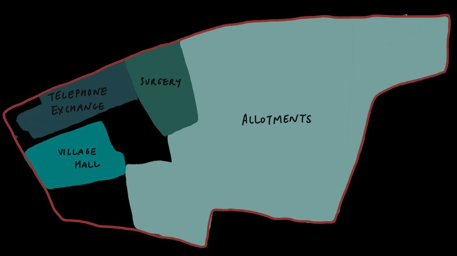

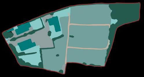
EXISTING : ECOLOGY & HABITATS
environment A&B
HABITAT PICTURE OF HABITAT ON SITE
Arable / allotments

Grassland - ranging in quality from low to medium.


DESCRIPTION? LOCATION ECOLOGICAL/ HUMAN IMPORTANCE?
The largest habitat currently on site, from the south-east side taking up just under half of the total site.
High human value.
Bottom field & around surgery has lush grassland, though still only one specie. Around telephone exchange, poor dried out grass. Other grass on borders of allotments paths/edges.
Potentially untouched woodland to north-west of site.
Some species rich, some poor (remove/improve poor quality, maintain high quality & add more)
Low ecological value & low/medium human value. In general grassland may be used in summer for picnics or sunbathing, but due to the location this is likely not the case.
KEY PLANT/ANIMAL SPECIES?
(species in bold are conservation species) DESIGN CONSIDERATION
Birds, including Skylark, Corn Bunting, Lapwing, Mistle Thrush, Fieldfare, Redwing, Reed bunting, Song Thrush and Mallard. Bats, including common Pipstrelle, Myotis, Brown Long-eared and Barbastelle.
Badger
Hedgehog
(Environmental Dimension Partnership Ltd, 2021)
Keep some allotments on site, however due to neighbourhood strategy of the local food trade network, there will be many more small-scale food growing spaces available, making less site-specific need for allotments. However they hold high historical & cultural value to both site & brief, so will be integrated into other human interventions on site.
Butterflies, bees & other insects. Retain a little single specie grassland for human value, otherwise create a higher value habitat, such as turning grassland into species-rich wildflower meadow, providing flowers from spring through to autumn.
High ecological value & medium human value. Badger Hedgehog
Many other small mammals, insects, birds, etc.
High ecological value. Birds eg. small numbers of Dunnock (Prunella Modularis), Yellowhammer (Emberiza Citrinella) and Linnet (Linaria cannabina). May breed on-site in association with the boundary hedgerows. Badger Hedgehog
(Environmental Dimension Partnership Ltd, 2021)
Retain & extend woodland, preventing anymore than small amounts of footfall. Allow a certain amount of footfall by day for human value & to prevent it potentially becoming a dumping ground.
Extend & maintain hedgerows. No species-rich hedgerow can be removed, if removig part of species-poor hedgerow, create species-rich hedgerow in another location on site. Make sure hedgerows span across site so wildlife are able to move just as easily as humans.


on the western edge of the site, to the north.
Rabbits & other small mammals
Badger
Broad-leaf Woodland
Hedgerow
Scattered Mature Trees
Scattered across site, some older than others.
ecological value. Birds Squirrels Insects
Mature trees must not be touched, with bird & bat boxes added.
EXISTING : MICRO-CLIMATE / SITE ANALYSIS
environment A
DESIGN CONSIDERATIONS:
SUN & SHADOW
Site south facing with small amounts of shadow, mostly from buildings and lines of trees. Add more trees to protect from strong summer sun, and maximise inside-outside spaces to the south with passive solar gain.
WIND
Existing and near-boundary trees act as windbreak, protecting site from harsh winds. Enhance and make use of cross ventilation.
CONTOURS
Site mostly flat, raising slightly to the north. Enhance views from sunspace to the south and use wildlife ponds to maximise SUDs.
ENTRANCES
Make use of existing entrances, with the northwest entrance more public and southern entrance more private, as the high-street is following Hexton Road north.
ANIMAL MOVEMENT
Movement of animals mostly kept to hedges and trees, so prioritise their travel paths with enhancement of hedgerows and other species-rich habitats. Retain existing woodland.
HUMAN MOVEMENT
Keep movement of vehicles to the boundary and enhance pedestrian routes, whilst keeping them partially separate to animals. This is particularly relevant on the weekend with increased pedestrian footfall.
CLIMATE CHANGE
Mitigations must be included for climate change as discussed in the System Change section, including:
• Deal with increased rainfall and extreme weather by adding overflow ponds and SUDs across site.
• Mitigate against overheating by harnessing cross ventilation & night cooling with thermal mass.


CONTOURS


ENTRANCES


SUN & SHADOW
WIND
LANDSCAPE DESIGN STRATEGY - OVERVIEW
environment C
>10% biodiversity net gain. Natural England
Ensure each development is resilient to known & predicted impacts of climate change (e.g. flood risk).
The provision of sufficient and frequent humannature interactions, throughout the Community to connect the majority of occupants with nature directly. LCC
Key
The project must be designed to human-scale rather than car-scale. LCC
Hard surface (Asphalt)
Permeable surfaces (Woodchip, Permeable paving)
Low-density planting (Grass, wildflower meadow, Allotments, Green roof)
High-density planting (Dense shrub, hedgerows, trees, woodland)
Retention ponds
Water course
Solar panels


Timber decking (Terrace, walkway)
Semi-translucent roof from collected waste polycarbonate

BREEAM Communities
HABITAT & SPECIES ENHANCEMENT
environment C, services B
HABITAT ENHANCEMENT & KEY PLANTING:
• Enhancement of existing hedgerows via gap planting with a species-rich mix of suitable native species, including blackthorn, hawthorn and field maple (Hedgelink, no date).
• New native tree and shrub planting with inclusion of flowering and fruiting species:
Alder (catkins provide an early source of nectar and pollen)
Blackthorn (flowers are an early springtime source of nectar and pollen for bees)
Wild cherry (important food for mammals and birds)
Crab apple (important food for mammals and birds)
(Woodland Trust, 2021)
• Creation of species-rich wildflower/meadow grassland which provides flowers through spring, summer and autumn.
• Bird boxes (house sparrow terraces, swift ‘nest bricks’ and swallow ‘cups’) and bat boxes across site, integrated/erected onto buildings, mature trees & in woodland
• Natural hibernaculum/log piles associated with retained vegetation, to enhance opportunities for hedgehog, reptiles and amphibians.
PROTECTION DURING CONSTRUCTION
• Careful consideration during construction to protect certain habitats and species.
• Any removal of habitat should take place in the winter months to avoid breeding season (eg skylark - ground nesting)
(Environmental Dimension Partnership Ltd, 2021)
Key
Hard surface (Asphalt)
Permeable surfaces (Woodchip, Permeable paving)
Low-density planting (Grass, wildflower meadow, Allotments, Green roof)
High-density planting (Dense shrub, hedgerows, trees, woodland)
Retention ponds
Water course
Solar panels
Timber decking (Terrace, walkway)
Semi-translucent roof from collected waste polycarbonate

EXTERNAL LIGHTING - WILDLIFE SENSITIVE SCHEME
Mitigation = minimise light spill
SUSTAINABLE DRAINAGE (SUDS)
Mitigation = flooding, drought. Creating resilience.
• Provide new opportunities for biodiversity through the provision of aquatic habitats in addition to flood. attenuation.
Explained in more detail in the Water Strategy.

• Low-level lighting directed away from habitats and pointing downwards. Increase shielding with hoods/covers.
• Minimise lighting at night and at dusk/dawn, allowing 'dark zones' for bats and other wildlife to retain/create linear foraging habitats and roosts.
• Lighting to have a warm white output (2700K or less) with directional capacity such as LED and with no UV component.
(Environmental Dimension Partnership Ltd, 2021)

WATER STRATEGY
To mitigate against the effects of climate change, many interventions have been added including a widespread SUDs scheme to prevent surface run-off and flash flooding in the event of heavy rainfall. This also prevents rainwater getting into the sewage system and utilising it instead.
CONNECTING TO MAINS
Part of the site is already connected to mains due to its existing buildings. This will be extended to include the housing scheme, and will include fresh water supply as well as grey and black water collection. Community water management including treatment is more efficient than per site as it uses less resources.
However, efforts on site must be made to reduce water usage, recycle water and prevent storm water getting into the sewage system.
COMPOST TOILETS
Reducing water use and also reliance on water, by having water-free compost toilets around the site. These are composted on-site in the compost areas and used on the non-edible plants (due to unknown contaminants), via different methods of composting - cold, warm and hot. However, external access and depth requirements mean not all toilets can be composting ones.
MINIMISE HARD SURFACES
Hard surfaces are minimised and permeable paving is used where it is required (see landscape design overview).
SEDUM ROOFS
Reduces surface runoff without overloading materials needed for an extensive roof. Can collect water and utlise it in the building.
OVERFLOW & RUNNEL
Allotments require a lot of water. By slowing down the amount of rainwater through green roofs and adding storage points for rainwater collection and storage, this combines an intensive strategy with low-impact interventions that don't require digging deep into the ground to add pipes.

Area of non-permeability:
The only non-permeable area on the site is the existing asphalt. To mitigate surface runoff, additional SuDS measures have been implemented. including the removal of a section of asphalt to create a detention basin. This not only addresses environmental concerns but also offers social benefits, transforming a plain car park into a more visually appealing space.
Clay soils on site:
The soil's high clay content results in poor drainage. To mitigate small-scale flooding, the site’s topography has been modified with the creation of two retention ponds. The excavated earth has been repurposed for use in the construction strategy
WATER-SAVING APPLIANCES
Water-saving taps are specified across the whole site. These are single-lever mixed taps fitted with Perlator, that mix air with the water, distributing the water flow which in affect reduces it (Block and Bokalders, 2010). A single tap instead of two is quicker to adjust to the right temperature. Adding in an automatic stop will reduce water consumption considerably.
Existing water taps from site that cannot be used due to this specification, can be redistributed across the neighbourhood where regulating water usage will have less of an impact - for example in homes where it is considered undesirable.
Toilets are required to be low-flush and urinals waterless. Existing toilets can be fitted with low-flushing devices so they don't have to be replaced.
Sinks will be plumbed in to connect to toilets so the same water is used multiple times, and with other sinks the grey water will be collected and used for irrigation (with only natural soaps will be used to ensure no harmful chemicals are present).
SERVICES STRATEGY
DISTRICT HEAT NETWORK
As discussed at neighbourhood scale, a district heat network is setup to create a more efficient system whilst retrofitting and including new homes. This will reduce reliance on fossil fuel systems and individual boilers, reducing consumption and minimising waste.
This requires two (flow and return) pipes to be fitted. The water will be heated to ambient temperatures, by waste heat from Barton-leClay's Industrial Centre, supplemented by ground source heat pumps. It will travel in the flow pipe between 20-30°C. Every building will have its own water source heat pump to heat the water to the required temperature.
By specifying a 5th generation heat network like ecotgrid, the network can also be used for cooling (E.ON, no date).
ELECTRICITY SUBSTATION
There is an existing substation by the workshops, which will be used for the whole site.
PIPE TRENCHES
Existing pipe trenches are used to minimise impact and resource use, extending the trench to reach the zero-waste housing scheme.
The pipe trench should follow pathways making it easier to access when servicing them, and reduces damage to the surrounding habitats.
This has been mapped, trying to balance minimising impact to habitats and minimising distances to reduce the amount of new piping.
PIPE TRENCH MAP
District heat networks must be set-up for both new-build and retrofitted homes in order to use previously wasted heat from non-domestic buildings. Own target.

DUCTING PIPE CONSIDERATIONS
Ducting pipes are colour coded so they are easily identifiable which reduces damage and minimises risk to those involved in the work
The water pipes for the heating network must be colour differently to ensure no confusion with water pipes (blue) or electricity pipes (red), which will also be situated at similar depths.
Recommended depths for different cables under pavements (Peace, 2024).

FIRE ACCESS
internal environment I
REQUIREMENTS
• ≥3.1m wide road for Fire Engine access
• Adequate turning points and circles (see below)
• 45 meters from the back of the fire engine to the furthest point of the furthest home.
(HM Government, 2022)
refuse truck turning circles
EXAMPLE TURNING POINTS

Non-asphalt pathways need to have a hard surface to ensure the fire engine can drive down it safely. Therefore along non-asphalt routes permeable pave stones are specified instead of a softer surface like wood-chip. Route with permeable paving (Western Interlock, no date).
Fire access here is not long enough to reach the furthest points of the housing. As an alternative, the pedestrian pathways either side of the common house are widened to allow for adequate fire access.


THE VILLAGE HUB
RETROFIT STRATEGY
construction A, internal environment A
PARTIAL RETROFIT STRATEGY:
A retrofit strategy for the two existing structures that are still fit for purpose - the existing village hall (waste centre) and telephone exchange (workshops) - to prevent construction waste. An internal retrofit strategy is employed to retain the local vernacular & celebrate the site.
A balance is employed between maximising the efficiency of the building whilst minimising waste of existing materials. Due to the renewable energy strategy - both on-site generation & neighbourhood generation, here keeping existing materials in-place is prioritised.
FABRIC EFFICIENCY
• Retrofitting internally to retain exterior aesthetic of existing buildings, need to consider moisture build-up & interstitial condensation so using less stringent EnerPHit requirements for U-values.
• With a materials-first approach, particularly the waste-center with 'waste' materials collected

WORKSHOPS