Healthy rivers and clean water are critical to Montana’s outdoor recreation and agricultural industries, fish and wildlife populations, and unmatched way of life.
The made-in-Montana, Montana Headwaters Legacy Act (MHLA) is new Wild and Scenic River legislation designed to protect Montana’s river legacy. Senator Jon Tester first introduced this legislation in the United States Senate in November 2020. The Montana Headwaters Legacy Act is composed of iconic streams that flow through public lands in the Greater Yellowstone Ecosystem and Smith River System. The streams in those regions are tributaries of the iconic Yellowstone and mighty Missouri Rivers. The current legislation includes segments of 20 streams totaling 383 river miles, representing less than 0.25% of Montana’s 177,000 miles of streams. When passed into law, this legislation will nearly double the number of Wild and Scenic River miles in Montana.
Montanans for Healthy Rivers (MHR) was formed in 2010 to keep Montana’s rivers clean and free-flowing for future generations. We are a broad-based coalition of Montana businesses, conservation organizations, angling and hunting groups, watershed groups, and riverside landowners who know that clean water and free-flowing rivers are important to our economy and way of life. Given the threats that our rivers face from climate change, future dams, energy development, floodplain development, mining and potential interstate water diversion schemes, we feel that now is the time to protect the streams that Montanans value the most.
Over the past decade, MHR has conducted extensive outreach with a broad cross section of Montanans to understand their river conservation concerns and provide literacy about the national Wild and Scenic Rivers Act. We have hosted 15 formal public river forums, five business roundtables, more than 25 targeted group presentations and nearly 50 public events. Annual gatherings like the Wild Rivers Film Tour have proven to be successful mediums to educate the public about new Wild and Scenic River protection opportunities in the region. Our outreach events have taken place in Billings, Big Sky, Big Timber, Bozeman, Butte, Columbia Falls, Condon, East Rosebud Lake, Roscoe, Emigrant, Ennis, Gardiner, Helena, Kalispell, Livingston, Missoula, Ovando, Red Lodge, Rock Creek, Seeley Lake, West Glacier and Whitefish. In addition, we spent a summer conducting targeted outreach at Fishing Access Sites within the proposed designation segments of the Gallatin and Yellowstone Rivers, as well as knocking on residential and commercial private landowner doors along these rivers. We have engaged hundreds of business owners from international companies like Sibanye Stillwater Mining to resorts like the Yellowstone Club and Big Sky Resort to energy utilities like Northwestern Energy to brick and mortar local shops.
We have also met with agricultural producers in places like the Gallatin Valley, Gardiner Basin, Boulder Valley, Madison Valley, Paradise Valley, and Stillwater Valley.
To date, the Montana Headwaters Legacy Act has received over 3,000 official endorsements, including more than 1,300 businesses, the chambers of commerce in Big Sky, Gardiner, and Red Lodge, and trade groups such as Montana Outfitters and Guides Association (representing 200 outfitters and guides), Fishing Outfitters Association of Montana (representing 700 outfitters and guides), Business for Montana Outdoors (representing 140 businesses across 20 industries), the Professional Wilderness Outfitters Association, and the Rural and Agricultural Council of America. We are also proud to have the support of all 11 Tribes of the Rocky Mountain Tribal Leaders Council, the Carbon County Commission, Gallatin County Commission, Madison County Commission, Madison Valley Ranchlands Group, Park County Commission, Mayors from Bozeman and Red Lodge, and the Montana Fish, Wildlife and Parks Commission. Furthermore, a recent statewide public opinion poll conducted in 2023 found that 85% of Montanans support the Montana Headwaters Legacy Act. A complete list of our supporters can be found on our website at healthyriversmt.org.
The bi-partisan led effort to pass the East Rosebud Wild and Scenic Rivers Act in 2018 proved that river conservation unites Montanans. Now we have a Montana born and bred Wild and Scenic Rivers bill to protect the next generation of streams that Montanans cherish.
AN ACKNOWLEDGMENT OF PEOPLE & RIVERS
Since long before the arrival of Euro-Americans and the beginning of the Western conservation movement, Montana’s rivers have been stewarded by Indigenous people who view these waters as sacred. The Indigenous way of caring for land and water acknowledges their life-giving energy, is centered within a paradigm of reciprocity, and uses Traditional Ecological Knowledge to keep the ecosystem in balance. The rivers within the Montana Headwaters Legacy Act run through the homelands of the Apsáalooke/Crow, Niitsitapi/ Blackfeet, Tukudeka/Sheepeater Shoshone, and other Indigenous peoples who are keepers of this knowledge and retain deep connections to these remarkable rivers.
The forced removal of Indigenous people in the 19th Century, the loss of Indigenous land stewardship practices and Indigenous place names that resulted, and the continued exclusion of Native voices from public lands management are realities we must acknowledge and confront. Recognizing and honoring Indigenous communities, values, beliefs, and practices are vital steps in honoring and restoring the cultural and ecological integrity of our rivers.
WILD AND SCENIC RIVERS ACT OVERVIEW
Congress passed the Wild and Scenic Rivers Act (WSRA) in 1968 at the height of the modern dam-building era in order to ensure that the construction of new dams on rivers is balanced with the protection of select free-flowing rivers that possess nationally significant values. This landmark law is the highest form of protection for rivers in the United States. The Wild and Scenic Rivers Act of 1968 (Public Law 90-542) in Section 1(b) expresses congressional policy for America’s rivers as follows:
“ItisherebydeclaredtobethepolicyoftheUnited States that certain selected rivers of the Nation which, with their immediate environments possess outstandingly remarkable scenic, recreational, geologic, fish and wildlife, historic, cultural,orothersimilarvalues,shallbepreservedin free-flowingcondition, and that they and their immediate environmentsshallbeprotectedforthe benefit and enjoyment of present and future generations.”
Wildlife biologists, John and Frank Craighead, came up with the idea for the Act while fighting the proposed Spruce Park Dam on the Middle Fork of the Flathead River in the 1950s in northwest Montana. These days the WSRA is often applied to headwaters streams that represent most of the best remaining clean, cold and connected rivers that remain in the U.S. The Wild and Scenic Rivers Act protects rivers in the following major ways:
• Protectsandenhancesariver’s“outstandinglyremarkable values” (ORVs) that can include fish, wildlife, recreation, cultural attributes, scenery, geology, or other regionallysignificant values.
• Protects existing uses of the river including recreational activities such as fishing and boating
• Protects a river’s free-flowing character and prohibits federally-licensed dams and other harmful water projects
• Establishes a 1/4-mile corridor on both sides of the river representing the zone of management focus
• Requires the creation of a comprehensive river management plan developed through a public process that addresses resource protection, land development, facilities and public use
• Can often help leverage federal funding for Improved recreation access and restoration projects
To be eligible for designation under the Wild and Scenic RiversAct,arivermustbefree-flowingandcontainatleastone outstandingly remarkable value. Free-flowing means “existing or flowing in a natural condition without impoundment, diversion, straightening, rip-rapping, or other modification of the water.”
To be considered as outstandingly remarkable, a river-related value must be a unique, rare, or exemplary feature that is significant at a comparative regional or national scale. While the spectrum of resources that may be considered is broad, all values should be directly river related.
CLASSIFICATION: Rivers are classified as wild, scenic, or recreational.
• WILD Those rivers or sections of rivers that are free of impoundments and generally inaccessible except by trail, with watersheds or shorelines essentially primitive and waters unpolluted. These represent vestiges of primitive America.
• SCENIC — Those rivers or sections of rivers that are free of impoundments, with shorelines or watersheds still largely primitive and shorelines largely undeveloped, but accessible in places by roads.
• RECREATIONAL Thoseriversorsectionsofriversthatare readily accessible by road or railroad, that may have some development along their shorelines, and that may have undergone some impoundment or diversion in the past.
Regardless of classification, each river in the National System is administered with the goal of protecting and enhancing the values that caused it to be designated. Designation neither prohibits development nor gives the federal government control over private property. Recreation, forestry practices, and other uses may also continue.
TheNationalWildandScenicRiversSystemcurrentlyincludes 226 river segments comprising 13,413 miles of river. That translates into approximately 0.25% of the river miles in the United States. Montana currently ranks 7th in the nation with a total of 388 Wild and Scenic river miles on five river segments: East Rosebud Creek, the Upper Missouri River and the three forks of the Flathead River. This amounts to about 0.2% of the river miles in Montana. Comparatively, Idaho has 22 Wild and Scenic Rivers covering 891 river miles, Wyoming has 14 Wild and Scenic Rivers covering 434 river miles, and Oregon has 68 Wild and Scenic Rivers covering 1,917 river miles.
The Montana Headwaters Legacy Act is an important step to protect pristine rivers across Montana and to build awareness about the critical role these tributaries play in powering our economy and outdoor heritage. We envision future legislation to address other new Wild and Scenic River designations in places like Montana’s Crown of the Continent, too.
MONTANA HEADWATERS LEGACY
Cabin Creek & Middle Fork Cabin Creek
Cabin Creek and the Middle Fork Cabin Creek flow out of the heart of the Cabin Creek Wildlife and Recreation Management Area below the Skyline Ridge, just east of the Madison Range. Their waters feed the Madison River below Hebgen Dam. These two streams carve through rugged canyons in the lower reaches and open meadows near the headwaters. Cabin Creek and Middle Fork Cabin Creek are best known for a successful native westslope cutthroat trout project completed to preserve their genetic purity from hybridization and competition with non-native rainbow trout that occasionally migrated upstream from the mainstem of the Madison River.
CABIN CREEK AND ITS TRIBUTARIES ARE HOME TO ONE OF THE LARGEST CONSERVATION POPULATIONS OF WESTSLOPE CUTTHROAT TROUT REMAINING IN THE GREATER YELLOWSTONE ECOSYSTEM. THE ABUNDANT FISH AND WILDLIFE FOUND IN CABIN CREEK AND THE SURROUNDING AREA ILLUSTRATE THE IMPORTANCE OF PROTECTING OUR HEADWATER STREAMS NOT ONLY FOR THE SERVICES THEY PROVIDE, BUT THE RARE AND UNIQUE ORGANISMS THEY SUPPORT.
— Mike Duncan, Montana Fish Wildlife & Parks
7.8 MILES
5.1 MILES
of the Cabin Creek proposed for Wild and Scenic designation
of the Middle Fork Cabin Creek proposed for Wild and Scenic designation
CLASSIFICATION:
(a)approximately 7.3 miles from the headwaters of Cabin Creek downstream to the fish barrier as wild
(b)approximately 0.5 miles from the fish barrier on Cabin Creek downstream to the confluence with the Madison River as recreational
(c)approximately 5.1 miles from the headwaters of Middle Fork Cabin Creek downstream to the confluence with Cabin Creek as wild
CHARLES DRIMAL
Cabin Creek & Middle Fork Cabin Creek
Gallatin River
The Gallatin River from the Yellowstone National Park boundary down to Spanish Creek is one of the most popular and easily accessible river reaches in Montana. Montanans and visitors alike cherish the Gallatin Canyon for its scenic limestone cliffs, abundant wildlife including the ever-present bighorn sheep near Big Sky, excellent trout fishing and challenging whitewater. Rafters and kayakers test their paddling skills in the class IV rapids of the Mad Mile, home to the notorious House Rock. Much of the Robert Redford film, A River Runs Through It, was shot in the Gallatin Canyon due to the river’s crystalline waters and scenic beauty.
OUR RIVERS ARE THE MOST WONDERFUL PART OF GALLATIN COUNTY. CLEAN WATERS AND VIBRANT RIVERS ARE THE VERY FOUNDATION OF OUR COMMUNITIES’ HEALTH AND ECONOMIC VITALITY. THAT’S WHY I WHOLEHEARTEDLY SUPPORT THIS BILL.
— Scott MacFarlane,
of the Gallatin River proposed for Wild and Scenic designation
CLASSIFICATION:
(a) approxiamately 39.3 miles from the Yellowstone National Park boundary downstream to the confluence of Spanish Creek as recreational 39.3 MILES
Chairman, Gallatin County Commission
SCOTT BOSSE
Gallatin River
Hyalite Creek
Hyalite Creek is characterized by the numerous waterfalls that drop sharply from its alpine source, Hyalite Lake. Steep, rugged, and wild, the waterway pours down from the mountains, carving its way through the north slope of the Gallatin Range. The creek feeds Hyalite Reservoir, the lifeblood of the Bozeman community, and a popular trail along the creek’s extent gives hikers, runners and mountain bikers a front-row seat to this spectacular scenery.
HYALITE CREEK NOT ONLY IS A PRIMARY SOURCE OF BOZEMAN’S DRINKING WATER, BUT IT IS ALSO ONE OF MONTANA’S MOST POPULAR DESTINATIONS FOR HIKERS, ANGLERS AND CROSS-COUNTRY SKIERS. AS SOMEONE WHO KNOWS AND LOVES HYALITE CREEK, I’D BE THRILLED TO SEE IT PERMANENTLY PROTECTED.
— Terry Cunningham, Bozeman City Commission
6.3 MILES
of Hyalite Creek proposed for Wild and Scenic designation
CLASSIFICATION:
from the source in the Gallatin Range downstream to Hyalite Reservoir as scenic
Hyalite Creek
Lower Madison River
While the Upper Madison River is internationally renowned by anglers, the Lower Madison River through Beartrap Canyon is less well known but equally cherished for its spectacular scenery, great trout fishing and boundless recreational opportunities including rafting, kayaking, hiking and camping. Upper Beartrap Canyon in the Lee Metcalf Wilderness Area features class IV-V rapids including the Kitchen Sink, reputed to be the most challenging commercially run whitewater rapid in the state. Downstream of Beartrap Canyon, the gradient of the river flattens out between Warm Springs and Black’s Ford, attracting a wide variety of river users including anglers, campers, rock climbers and inner-tubers during the summer months.
BEARTRAP CANYON IS A UNIQUELY MONTANA EXPERIENCE. FORTY FIVE MINUTES FROM MY HOUSE AND I’M IMMERSED IN A TRUE RIVER WILDERNESS WITH WHITEWATER, WILDLIFE, AND STUNNING SCENERY. MY THREE-YEAR-OLD DAUGHTER HAS WALKED THE BANKS AND SPLASHED IN THE EDDIES; THIS SUMMER SHE’LL BE BIG ENOUGH TO HIKE IN AND FLOAT DOWNSTREAM OF THE KITCHEN SINK. I WANT THE MADISON TO REMAIN AS PRISTINE FOR HER AS IT IS FOR ME. WILD AND SCENIC PROTECTS THE IMPORTANT PLACES FOR HER FUTURE. I DON’T KNOW OF MANY MORE IMPORTANT THAN BEARTRAP.
— Chris Ennis, 2004 Olympic Paddler and Bozeman resident
14.9 MILES
proposed for Wild and Scenic designation
CLASSIFICATION:
(a) approximately 7.5-mile segment from 800 feet downstream of Madison Dam Powerhouse downstream to the Lee Metcalf Wilderness boundary as wild
(b) approximately 7.4 miles from Lee Metcalf Wilderness Area boundary to the BLM boundary at the Black’s Ford Fishing Access Site as recreational
SCOTT BOSSE
Lower Madison River
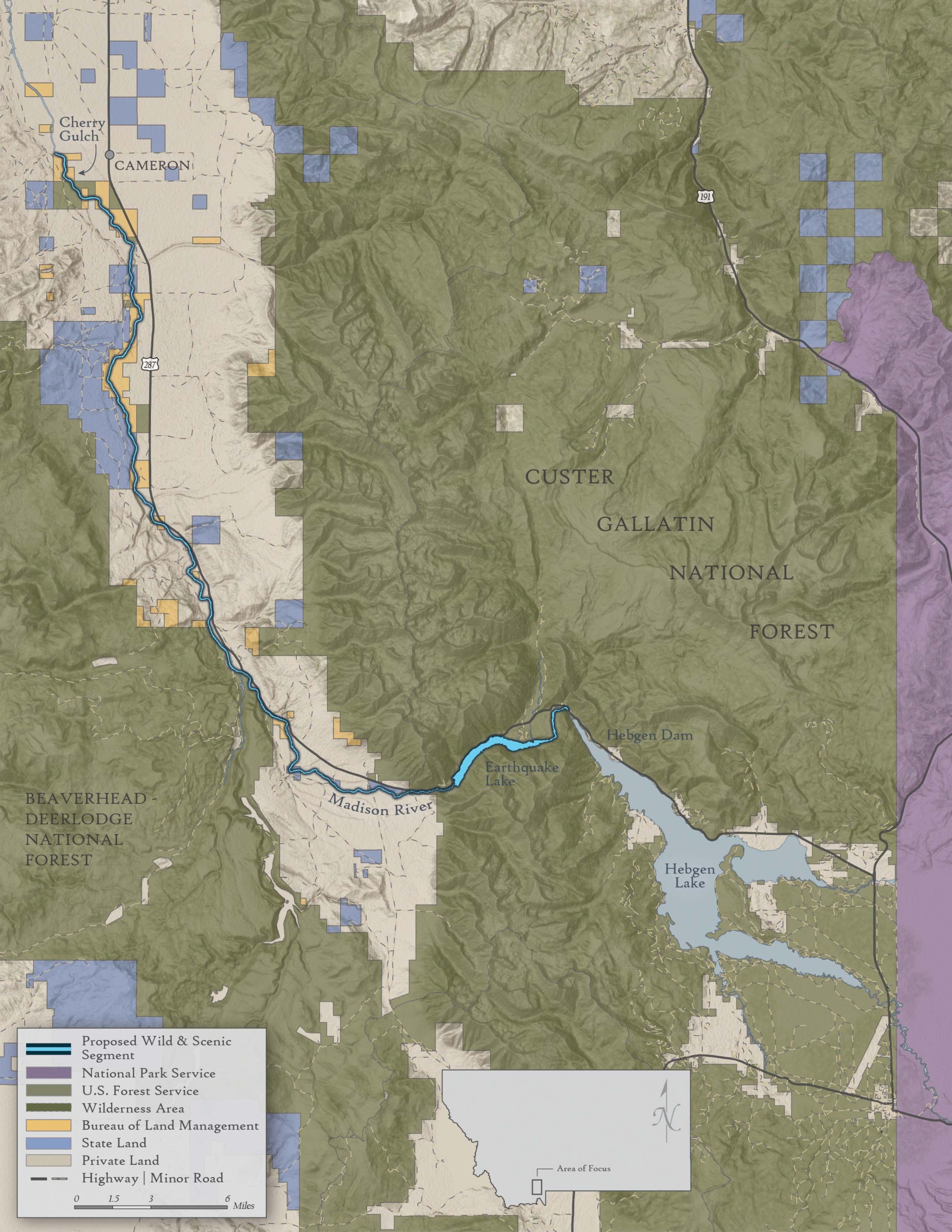
Upper Madison River
The Upper Madison is a river of many personalities. Between Hebgen Dam and Quake Lake, it flows through a stunning canyon where mountain goats are often spotted on the surrounding cliffs. Below Quake Lake, the river cascades down through the rubble of a massive landslide that was triggered by the 1959 earthquake. At Raynold’s Pass, the river becomes the infamous 50-mile riffle on which trout anglers from around the world congregate. The public-access site at Three Dollar Bridge is one of the most revered fishing shrines on the planet. The middle of the Madison Valley offers critical habitat for large elk herds, pronghorn, and grizzly bears. The landscape has a long history of Blackfeet Tribal occupancy going back millenia.
41.5 MILES
miles of the Upper Madison River proposed for Wild and Scenic designation
I FIRST GOT TO KNOW THE UPPER MADISON WHEN MY DAD TOOK ME FISHING THERE AS A 4-YEAR-OLD KID. I PLACED THREE DOLLAR BILLS INTO THE SMALL WOODEN BOX AT THREE DOLLAR BRIDGE, HOISTED UP BY MY DAD. I KNEW IT WAS A SPECIAL PLACE THEN, AND MY LOVE FOR IT HAS ONLY GROWN STRONGER AS I’VE GOTTEN OLDER. AS A LANDOWNER ALONG THE RIVER FOR THE PAST 22 YEARS, I SUPPORT IT BEING DESIGNATED AS WILD AND SCENIC BECAUSE I WANT TO SEE IT STAY THE WAY IT IS – CLEAN, BEAUTIFUL AND RICH WITH WILDLIFE.
— Roger Lang, Madison River landowner
THE SUN RANCH IS FORTUNATE TO BE SITUATED ON THE BANKS OF THE MADISON RIVER. ALONGSIDE OUR NEIGHBORS, WE SHARE AN ABUNDANT LOVE FOR THE ICONIC MADISON RIVER AND THE IRREPLACEABLE LANDSCAPE IT DEFINES. THE RIVER IS A WORKHORSE FOR LOCAL AGRICULTURAL IRRIGATION AND A BOOMING OUTDOOR RECREATION ECONOMY. THE RIVER SUPPORTS A STUNNING ARRAY OF WILDLIFE FROM MIGRATING ELK TO ANTELOPE, DEER AND UNIQUE WATERFOWL LIKE THE TRUMPETER SWAN. WE ARE GRATEFUL THAT THE MONTANA HEADWATERS LEGACY ACT WILL HELP CONSERVE THE HERITAGE OF THIS PLACE.
— Charles Goodyear, Sun Ranch, Madison River
CLASSIFICATION:
approximately 41.5-mile segment from the confluence of the Madison river and Cabin Creek downstream of Hebgen Dam to approximately one mile north of Cherry Creek Gulch on BLM lands near Cameron, Montana as recreational
SCOTT BOSSE
Upper Madison River
Smith River
The most beloved river of its size in Montana, the Smith flows through a spectacular 59-mile-long canyon between Camp Baker and Eden Bridge. Each winter, thousands of Montanans enter a lottery—the only one of its kind in the state—with the hope of being drawn for the chance to float the river the following spring. The proposed Wild and Scenic reach features 1,000-foothigh limestone canyon walls, excellent fishing for brown and rainbow trout, numerous Native American pictograph sites, and some of the best remote riverside camping anywhere in the United States. The river is threatened by a proposed underground copper mine at the headwaters of Sheep Creek, one of its major tributaries.
OUR FAMILY HAS OWNED OUR RANCH OVERLOOKING THE SMITH RIVER FOR FORTY YEARS. FOR US, THERE IS NO MORE BEAUTIFUL PLACE ON EARTH. THIS IS WHERE WE GATHER AS A FAMILY, WORK ON THE LAND, HUNT AND FISH, AND TEACH OUR CHILDREN THE IMPORTANCE OF THE RIVER AND THE NATURAL WORLD. WE WOULD LOVE NOTHING MORE THAN TO SEE THE SMITH PROTECTED AS A WILD AND SCENIC RIVER.
— Guido Rahr, Smith River landowner
24.1 MILES
of the Smith River proposed for Wild and Scenic designation
CLASSIFICATION: from confluence of Tenderfoot Creek downstream to the confluence of Deep Creek as scenic
SCOTT BOSSE
Smith River
Taylor Creek
Also known as the Taylor Fork, this scenic tributary of the Gallatin River is known for its stunning views of the east front of the Madison Range and abundant wildlife, including a large population of resident grizzly bears and thousands of elk that migrate through the valley on their way from Yellowstone National Park to the Madison Valley. The Taylor Fork drainage was once comprised of checkerboard lands that were highly vulnerable to development, but the Gallatin II Land Exchange in 1998 consolidated all but a few pieces into public ownership.
OUR FAMILY HAS BEEN PRIVILEGED TO LIVE IN AND ENJOY THE TAYLOR FORK DRAINAGE FOR FOUR GENERATIONS. THE VALLEY OFFERS UNIQUE RECREATING OPPORTUNITIES FOR THE RAPIDLY EXPANDING BOZEMAN AREA/BIG SKY POPULATIONS AND FOR VISITORS TO NEARBY YELLOWSTONE NATIONAL PARK. THE ADDITIONAL PROTECTIONS AFFORDED THIS NATURAL TREASURE BY THE WSR LEGISLATION ARE ESSENTIAL TO ITS PRESERVATION FOR FUTURE GENERATIONS.
— Sandy Alexander, Taylor Creek landowner
17.6 MILES
proposed for Wild and Scenic designation
CLASSIFICATION:
(a) 3 miles from source to the Lee Metcalf Wilderness Area boundary as wild
(b) 14.6 miles from Lee Metcalf Wilderness Area boundary to Gallatin River confluence as recreational
SCOTT BOSSE
Taylor Creek
Tenderfoot Creek
The most pristine tributary of the Smith River, Tenderfoot Creek originates in the Little Belt Mountains and cascades 3,250 feet in elevation through dense pine forests filled with elk, moose, mule deer, black bear and wolves. It is a prime destination for anglers due to its gin-clear water and abundant rainbow and brown trout. Tenderfoot Creek is one of the few tributaries in the Smith River system that still harbors a resident population of native westslope cutthroat trout. While most of Tenderfoot Creek flows across the Helena – Lewis and Clark National Forest, 8,220 acres of privately-owned creekside lands were added to the public domain in 2018 using funds from the Land and Water Conservation Fund (LWCF).
THE TENDERFOOT IS A GREAT BACKCOUNTRY TROUT FISHERY. IT IS ONE OF MY FAVORITE PLACES TO BACKPACK WITH A TENKARA ROD. THE RIVER’S PRISTINE QUALITIES AND ROADLESS SURROUNDINGS IN THE LITTLE BELT MOUNTAINS MAKE IT A PERFECT CANDIDATE FOR WILD AND SCENIC RIVER DESIGNATION.
— Steve Platt, Avid sportsman, Helena MT
21.5 MILES
of Tenderfoot Creek proposed for Wild and Scenic designation
CLASSIFICATION:
from the confluence with Iron Mines Creek downstream to the confluence with the Smith River as scenic
SCOTT BOSSE
Tenderfoot Creek
Bear Creek
Flowing from 10,000-foot peaks in the Absaroka-Beartooth Wilderness, Bear Creek is situated amongst important wildlife habitat. Bear Creek contains mule deer and elk migration routes that extend from Yellowstone National Park immediately to the south, down to lower-elevation private lands to the northwest. Scientists have documented wolverine using the habitat and it is considered high-value core grizzly bear habitat. Several outfitters and guides use the trail system for hunting, backpacking and camping within the Custer Gallatin National Forest.
MY FATHER MOVED MY FAMILY TO THE BANKS OF THE YELLOWSTONE RIVER IN 1953 TO START A FLY FISHING SHOP AND GUIDING BUSINESS ON ONE OF AMERICA’S LAST, ICONIC FREE-FLOWING RIVERS. IN A VERY REAL SENSE THE FISH ARE OUR BUSINESS PARTNERS, WATER QUALITY IS A KEY FACTOR IN THEIR AND OUR HEALTH. OVER THE DECADES WE HAVE SEEN MANY ILL-JUDGED SCHEMES INCLUDING DAMS, MINING PROJECTS, GEO-THERMAL DEVELOPMENT, AND HYDRO POWER DIVERSIONS PROPOSED AND ARE HAPPY TO SEE THE MONTANA HEADWATERS LEGACY ACT OFFER PERMANENT PROTECTIONS FOR THE UPPER YELLOWSTONE RIVER AND BEAR CREEK.
— Richard Parks, Parks Fly Shop
8.9 MILES
of Bear Creek proposed for Wild and Scenic designation
CLASSIFICATION:
(a) approximately 1.6-mile segment from the source downstream to the AbsarokaBeartooth Wilderness boundary as wild
(b) approximately 7.3-mile segment from the AbsarokaBeartooth Wilderness boundary to the confluence with the Yellowstone River as recreational
JIM HEPBURN
Bear Creek
Boulder River
Originating deep within the Absaroka-Beartooth Wilderness, the Boulder River is cherished for its beautiful scenery, under-theradar trout fishing and excellent riverside camping. The Natural Bridge at the lower end of the public lands reach is a sight to behold during spring runoff when the river thunders over a 105-foot-high limestone amphitheater. During lower-flow periods, the river disappears into a hole in the rock and pours out of a cave lower on the cliff. The remarkable values for the Boulder, as determined by the Forest Service include recreational, scenic, geological and historic.
OUR FAMILY SPENDS SUMMERS AT OUR RANCH BY THE CONFLUENCE OF THE WEST BOULDER AND BOULDER RIVERS. IT’S HUGELY IMPORTANT TO US THAT THE HEADWATERS OF THESE TWO ICONIC RIVERS BE PROTECTED. THIS ENSURES THAT THE FISH AND THE WILDLIFE WILL CONTINUE TO FLOURISH, AND THE WATER OF THESE PRECIOUS RIVERS REMAINS CLEAN AND FREE FLOWING IN PERPETUITY.
— Nan Newton & Dave Grusin, McLeod, MT
33.4
MILES
of the Boulder River proposed for Wild and Scenic designation
CLASSIFICATION:
(a) approximately 3-mile segment from the source in the Absaroka-Beartooth Wilderness downstream to the Wilderness boundary as wild
(b) approximately 30.4-mile segment from the AbsarokaBeartooth Wilderness boundary downstream to the Custer Gallatin National Forest boundary downstream of Natural Bridge Falls as recreational
SCOTT BOSSE
Boulder River
West Boulder River
The largest wild tributary to the Boulder River, the West Boulder River originates deep in the Absaroka-Beartooth Wilderness Area. For those who are willing to hike into the Wilderness, rewards await in the form of gorgeous views, excellent trout fishing and outstanding backcountry camping. The glassy meadow section of the river tests the skills of even the most accomplished fly anglers, while the whitewater section immediately downstream is prized by packrafters in search of solitude and adventure. Wildlife including elk, deer and grizzly bears are common along the public-lands reach of the West Boulder, and rare native Yellowstone cutthroat trout inhabit its frigid, crystal clear waters.
I HAVE LIVED IN THE UPPER YELLOWSTONE BASIN FOR A VERY LONG TIME, MOST OF IT ALONG THE WEST BOULDER, A RIVER SMALL ENOUGH THAT EARLY MAPS CALL IT A “CREEK”. ORIGINATING IN THE WILDERNESS FROM SO MANY SEEPS AND TRICKLES THAT FEW UNDERSTAND ITS ORIGINS, IT IS THE MOST BEAUTIFUL, PRISTINE FREESTONE RIVER I HAVE EVER SEEN. IT EMPHATICALLY DESERVES PROTECTION UNDER THE WILD AND SCENIC ACT.
— Tom McGuane, Author and Angler, McLeod, MT
14.5 MILES
of the West Boulder River proposed for Wild and Scenic designation
CLASSIFICATION: from the source to the Absaroka-Beartooth Wilderness Area boundary as wild
West Boulder River
Clarks Fork of the Yellowstone
Paralleling the Beartooth Scenic Byway, the Clarks Fork of the Yellowstone, from its confluence with the Broadwater River downstream to the Wyoming border, is an extremely, visually stunning landscape. At the Clarks Fork Trailhead and Picnic Area, boulders and outcrops form a scenic waterfall across the entire channel that provide contrast to the view of Montana’s iconic Granite Peak in the distance. Further downstream, breathtaking cascades create juxtaposition to towering volcanic spires of Index and Pilot Peaks in the Absaroka Range directly to the south. These waters that originate in Montana flow down into an existing Wild and Scenic River segment of the Clarks Fork of the Yellowstone in Wyoming where world class paddlers challenge their skills in the Box Canyon.
PROTECTING THE MONTANA HEADWATERS OF THIS RIVER AS WILD AND SCENIC WILL HELP ENSURE THAT NEW GENERATIONS OF PADDLERS CONTINUE TO EXPERIENCE THE WILDNESS AND MAJESTY OF THIS LANDSCAPE INTO THE FUTURE.
—Dave
2.6 MILES
miles of the Clarks Fork of the Yellowstone proposed for Wild and Scenic River designation
CLASSIFICATION:
(a) approximately 0.7-mile segment from Broadwater River downstream to the Absaroka-Beartooth Wilderness boundary, to be administered by the Secretary of Agriculture as a scenic
(b) approximately 1.9-mile segment from Absaroka-Beartooth Wilderness boundary downstream to the Montana-Wyoming State line, to be administered by the Secretary of Agriculture as a wild
Zinn, owner and founder of Wave Train Kayak Team
Clarks Fork of the Yellowstone
Hellroaring Creek
Hellroaring Creek carves a rugged canyon down low with fast moving, turbulent waters that ultimately flow into the Yellowstone River in Yellowstone National Park. Up high, the watershed opens up to a broad valley and views of the high alpine peaks of the Absaroka Range within the Absaroka-Beartooth Wilderness. Hellroaring Creek contains a pure native Yellowstone cutthroat trout population and hosts two mule deer migration routes. It also contains high-value core grizzly bear habitat and is the eastern edge of occupied wolverine habitat. While much of the Absaroka-Beartooth Wilderness is high-elevation, rocky plateau country, places like Hellroaring Creek and Slough Creek offer important low-elevation habitat for wildlife and clean, cold water native fish need to complete their life cycles.
HELLROARING AND SLOUGH CREEKS FLOW THROUGH IMPORTANT LOW-ELEVATION HABITATS IN A WILDERNESS AREA THAT IS MOSTLY HIGH ALTITUDE SUBALPINE AND ALPINE TERRAIN. THESE WILD VALLEYS TEEM WITH WILDLIFE AND ARE PARTICULARLY IMPORTANT FOR RARE, THREATENED AND ENDANGERED SPECIES SUCH AS GRIZZLY, WOLVERINE, LYNX AND YELLOWSTONE CUTTHROAT TROUT, PLUS HEALTHY POPULATIONS OF ELK, MOOSE, AND MULE DEER. OVER THE LAST FOUR DECADES I HAVE SPENT MANY DAYS AND NIGHTS HIKING AND CAMPING IN THESE AREAS; THESE VALLEYS ARE AMONG THE WILDEST AND MOST BEAUTIFUL MOUNTAIN RIVER VALLEYS ANYWHERE. WILD AND SCENIC RIVER STATUS IS THE ESSENTIAL CLASSIFICATION THAT WILL GIVE THESE RIVERS AND THEIR RIPARIAN VALLEYS THE PERMANENT PROTECTION THEY DESERVE.
— Howie Wolke, Founder of Big Wild Adventures
19.2 MILES
of Hellroaring Creek proposed for Wild and Scenic designation
CLASSIFICATION:
from the source in the Absaroka-Beartooth Wilderness downstream to the Custer Gallatin National Forest boundary as wild
Hellroaring Creek
Rock Creek
Rock Creek provides jaw-dropping views of a gorgeous U-shaped glacially carved valley along the Beartooth Highway, a National Scenic Byways All-American Road. Situated on the Custer Gallatin National Forest, it is a recreational mecca for the Red Lodge community and nearby city of Billings. Here you can find campgrounds, trailheads and fishing and swimming opportunities. Rock Creek begins high up on the Beartooth Plateau in Montana, then flows through Wyoming for a couple miles, and finally wraps to the north back in Montana, dropping elevation but still charging with technical whitewater gradient. The creek is part of the traditional homelands of the Apsaalooke/Crow tribe and is important as it marks the site of a significant battle with the neighboring Shoshone tribe.
THE APSAALOOKÉ NATION HAS REVERED THE RIVERS OF THE YELLOWSTONE REGION SINCE TIME IMMEMORIAL. APSAALOOKÉ CULTURE BELIEVES THAT WATER IS LIFE AND A GREAT GIFT TO BE CHERISHED. OUR OWN ANCIENT LEGACY AS CARETAKERS OF THESE RIVERS IS CELEBRATED BY THE MONTANA HEADWATERS LEGACY ACT, AND WE SUPPORT THIS LANDMARK LEGISLATION.
— Shane Doyle, Apsaalooke/Crow Natural Resources Liaison to Greater Yellowstone
13.6 MILES
of Rock Creek proposed for Wild and Scenic designation
CLASSIFICATION:
from the Montana-Wyoming boundary to the Custer Gallatin National Forest boundary as recreational
Rock Creek
Lake Fork Rock Creek
The Lake Fork of Rock Creek includes spectacular alpine scenery, sections of a steep and fast flowing creek, waterfalls, and high-elevation plateaus that stretch across the horizon. The Lake Fork of Rock Creek offers popular backpacking and hiking opportunities into the Absaroka-Beartooth Wilderness. Many people hike, run and backpack from the Lake Fork trailhead, over Sundance Pass and into the West Fork of Rock Creek.
I LIVED ON THE MAIN FORK OF ROCK CREEK FOR 32 YEARS. OVER THAT TIME, MY WORK AS A SCIENCE AND NATURE WRITER FOR NATIONAL GEOGRAPHIC AND OTHER PUBLISHERS LED ME TO UNDERTAKE LITERALLY HUNDREDS OF FORAYS UP AND DOWN THE LENGTH OF ALL THREE STEMS OF ROCK CREEK: THE MAIN FORK, LAKE FORK, AND WEST FORK. THIS IS TRULY A REMARKABLE WATERSHED – NOT JUST IN TERMS OF ITS UNMATCHED RECREATIONAL OPPORTUNITIES, BUT ALSO BECAUSE IT PROVIDES CRITICAL HABITAT FOR AN ASTONISHING VARIETY OF WILDLIFE, FROM MOOSE TO MINK. WITH THAT IN MIND, I OFFER MY ENTHUSIASTIC SUPPORT FOR PROTECTING ROCK CREEK UNDER THE WILD AND SCENIC RIVERS ACT.
— Gary Ferguson, Author, Bozeman, MT
13
MILES
of Lake Fork Rock Creek proposed for Wild and Scenic designation
CLASSIFICATION:
(a) 10.7 miles from the source in the Absaroka-Beartooth Wilderness downstream to the Wilderness boundary as wild
(b) 2.3 miles from the AbsarokaBeartooth Wilderness boundary to the confluence with Rock Creek as recreational
MIKE FIEBIG
Lake Fork Rock Creek
West Fork Rock Creek
West Fork Rock Creek starts as a gorgeous creek meandering through open subalpine meadows and then presenting views of stunning high-alpine granite rock walls and peaks in the Beartooth Range. The West Fork provides access to some of the most popular hiking trails and backpacking routes within the Beartooth Ranger District of the Custer Gallatin National Forest. Historic camps and ranger stations are found along the stream and it has been a recreational epicenter for the community of Red Lodge for decades.
THANK YOU SENATOR TESTER FOR RECOGNIZING THE IMPORTANCE OF THE WEST FORK OF ROCK CREEK AND FOR INCLUDING IT IN THE MONTANA HEADWATERS LEGACY ACT. OUR GUESTS AT BANNOCK TRAIL LODGE ALONG THE BANKS OF THE CREEK ENJOY THE OPPORTUNITY TO VIEW WILDLIFE, HIKE, FISH AND APPRECIATE THE BEAUTY OF THIS PLACE. THIS WATERSHED IS ALSO AN IMPORTANT SOURCE WATER SUPPLY FOR THE CITY OF RED LODGE. IT DESERVES WILD AND SCENIC RIVER PROTECTION.
— Mike Penfold, Bannock Trail Lodge
19.9 MILES
of West Fork Rock Creek proposed for Wild and Scenic designation
CLASSIFICATION:
(a) includes 8.9 miles from the source in the Absaroka-Beartooth Wilderness downstream to the Wilderness boundary as wild
(b) ncludes 11 miles from the Wilderness boundary downstream to the Custer Gallatin National Forest boundary as recreational
West Fork Rock Creek
Slough Creek
Slough Creek is a large, relatively low-elevation creek that flows from deep within the Absaroka-Beartooth Wilderness and is most recognized for containing a pure Yellowstone cutthroat trout population, thanks to conservation efforts by Montana Fish, Wildlife and Parks and the National Park Service. Slough Creek hosts high-value core grizzly bear habitat according to Craighead Institute models in the lower and upper reaches. Important elk and mule deer herds migrate in and out of Yellowstone National Park and into the Stillwater watershed, according to the Wildlife Conservation Society data. With amazing fishing, camping and hiking opportunities, this remote creek is a gem within the Custer Gallatin National Forest.
18.5 MILES
of Slough Creek proposed for Wild and Scenic designation
CLASSIFICATION:
from the source in the Absaroka-Beartooth Wilderness downstream to the Custer Gallatin National Forest boundary as wild
SCOTT BOSSE
Slough Creek
Stillwater River
The Stillwater River provides a mix of steep granite rock walls in a lower gorge, a wide meandering river at mid-reach, and alpine walls up high with thundering waterfalls. The Stillwater River is a popular destination for fishing, technical whitewater kayaking, hiking, backpacking and hunting. There is a unique geologic gorge above the Woodbine trailhead that attracts many day-hikers. The Stillwater River watershed contains high-value core grizzly bear habitat, based on Craighead Institute models, as well as winter range for moose, according to Montana Fish, Wildlife and Parks.
SIBANYE-STILLWATER HAS SHOWN THAT RESPONSIBLE RURAL ECONOMIC DEVELOPMENT CAN CO-EXIST WITH RECREATION AND RESOURCE PRESERVATION. SIMILARLY, THE PROVISIONS IN THE MONTANA HEADWATERS LEGACY ACT ENCOURAGE THE BALANCE OF SUSTAINABLE DEVELOPMENT WITH THE PROTECTION OF OUR NATURAL RESOURCES. AS A RESULT, SIBANYE-STILLWATER IS PLEASED TO SUPPORT AND ENDORSE THESE WILD AND SCENIC RIVER PROTECTIONS.
— Chris Bateman, Executive Vice President, Sibanye-Stillwater Mining Company
28.8
MILES
of the Stillwater River proposed for Wild and Scenic designation
CLASSIFICATION:
(a) 25.7 miles from the source of the river in the Absaroka-Beartooth Wilderness downstream to the Wilderness boundary as wild
(b) approximately 3.1 miles from the Wilderness boundary downstream to Flume Creek as recreational
KERRI
RYAN
Stillwater River
West Fork Stillwater River
Surrounded by steep mountain faces, the West Fork Stillwater River is a remote drainage that flows out of the heart of the Absaroka-Beartooth Wilderness on the Custer Gallatin National Forest. The West Fork Stillwater River hosts a diversity of wetlands, open meadows, steep cliffs and dense forests. The terrain and vegetation offer high-value core grizzly bear habitat and important elk and moose winter range.
14.4 MILES
of the West Fork Stillwater proposed for Wild and Scenic designation
CLASSIFICATION:
from the source in the Absaroka-Beartooth Wilderness downstream to the Wilderness boundary as wild
SCOTT BOSSE
West Fork Stillwater River
Yellowstone River
The longest free-flowing river in the lower 48 states, the Yellowstone flows for 692 miles from its headwaters on Yount’s Peak in Wyoming to the confluence with the Missouri River in North Dakota. The proposed Wild and Scenic reach extends from the Yellowstone National Park boundary down through Yankee Jim Canyon to the confluence with Tom Miner Creek. Recreationists from across Montana and around the country flock to this scenic reach to fish for trout, whitewater raft and watch for wildlife such as elk, bighorn sheep, bison, osprey and bald eagles. Among the spectacular sights on this reach is the Devil’s Slide, a unique geological formation on the east side of Cinnabar Mountain.
AS SOMEONE WHO GREW UP ALONG THE BANKS OF THE YELLOWSTONE RIVER, AND AS A FARMER WHO HAS GROWN FOOD FOR EIGHT YEARS ON AN ISLAND IN THE MIDDLE OF THIS RIVER- I COULD NOT BE MORE SUPPORTIVE OF THE WILD AND SCENIC RIVER BILL. IT IS OF UTMOST IMPORTANCE TO ME AS A MONTANAN AND AN AGRICULTURE PRODUCER TO PRESERVE THE PRISTINE NATURE OF OUR RIVERS.
— Sam Mascari, Montana Roots
AS A BUSINESS OWNER WITH DIRECT TIES TO THE OUTDOOR RECREATION ECONOMY AND AS A MONTANAN BORN AND RAISED IN LIVINGSTON, I COULDN’T BE MORE PROUD TO SEE THIS IMPORTANT LEGISLATION INTRODUCED TO PROTECT THE UPPER YELLOWSTONE AND OTHER ICONIC STREAMS AS WILD AND SCENIC RIVERS.
— Dale Sexton, Dan Bailey’s Outdoor Company
18.1
MILES
of the Yellowstone River proposed for Wild and Scenic designation
CLASSIFICATION: from the Yellowstone National Park boundary in Gardiner downstream to Rock Creek near the Carbella Fishing Access Site as recreational