*The majority of the Easton East End Study Area is located in Ward 4.
Department of Planning and Zoning
Miguel Salinas, Director of Planning and Zoning
Lynn Thomas, Town Planner
Joseph Mayer, Plan Reviewer
Nicholas Johnson, Planner
Samantha Smith, Administrative Specialist
Department of Engineering
Rick Van Emburgh, Town Engineer
Kody Cario, Project Manager
Easton Utilities
Doug Abbott, Director - Engineering, Gas, Water, Wastewater
Aaron K. Goller, Senior Engineer
Easton Economic Development Corporation
Holly DeKarske, Executive Director
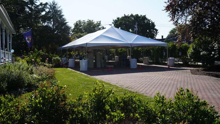
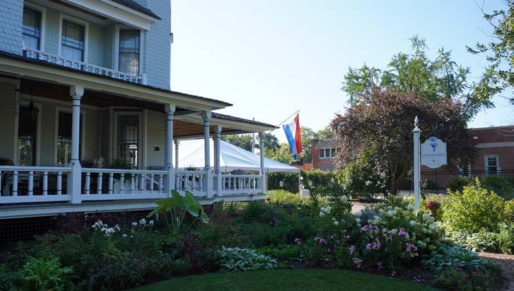
Special Thanks to Pastor Josh Maxwell and his team, and congregation of the Easton Church of God for hosting the Charrette.
Consultant Team
Seth Harry, President, Seth Harry and Associates, Inc.
David Ager, Principal, Townscape
Keith Covington, RA, Common Ground Design
Dylan Zingg, Landscape Architect
Samantha Mincarelli, Architect
Contributing Architects & Planners
Virginia Richardson, Vice President - Architecture, Rauch Engineering
Eric M. Catellier, Senior Architect, Rauch Engineering
Andrew Bernish, Senior GIS Planner & Analyst, Maryland Department of Transportation
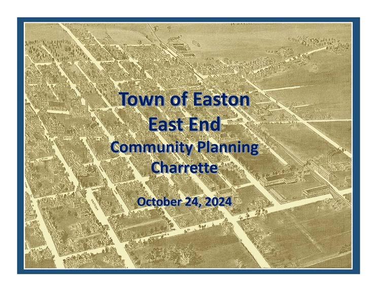
The Town of Easton...
... was founded in 1710 by an Act of the Assembly of the Province of Maryland for the purpose of building a court house at “Armstrong’s Old Field near Pitt’s Bridge”. Pitts Bridge was a crossing of the headwaters of the Tred Avon (Third Haven) River at what is now Washington Street. In addition to the court house, a tavern was one of the first buildings erected, with stores and dwellings following so thereafter. This early village was known as “Talbot Court House”.
Easton has seen many changes since it’s birth. The evolution of the “East End” is yet another phase of change for the Town. This summary of the October 2024 Charrette is an attempt to inform and offer suggestions for the next great addition to the Town.
1.Executive Summary
Overview
As part of Easton’s Comprehensive Plan update, the Town engaged a multidisciplinary consultant team to undertake a 3-stage public outreach and engagement planning process to update the Town’s East End Small Area Plan. The Town has a long history of pro-active community involvement in long-term planning initiatives, and this latest Small Area Plan is itself an update to the East End Housing and Neighborhood Revitalization Plan, originally approved by the Town of Easton in September, 1997.
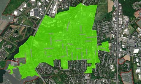
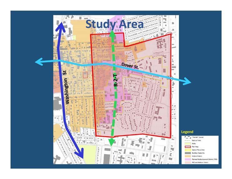
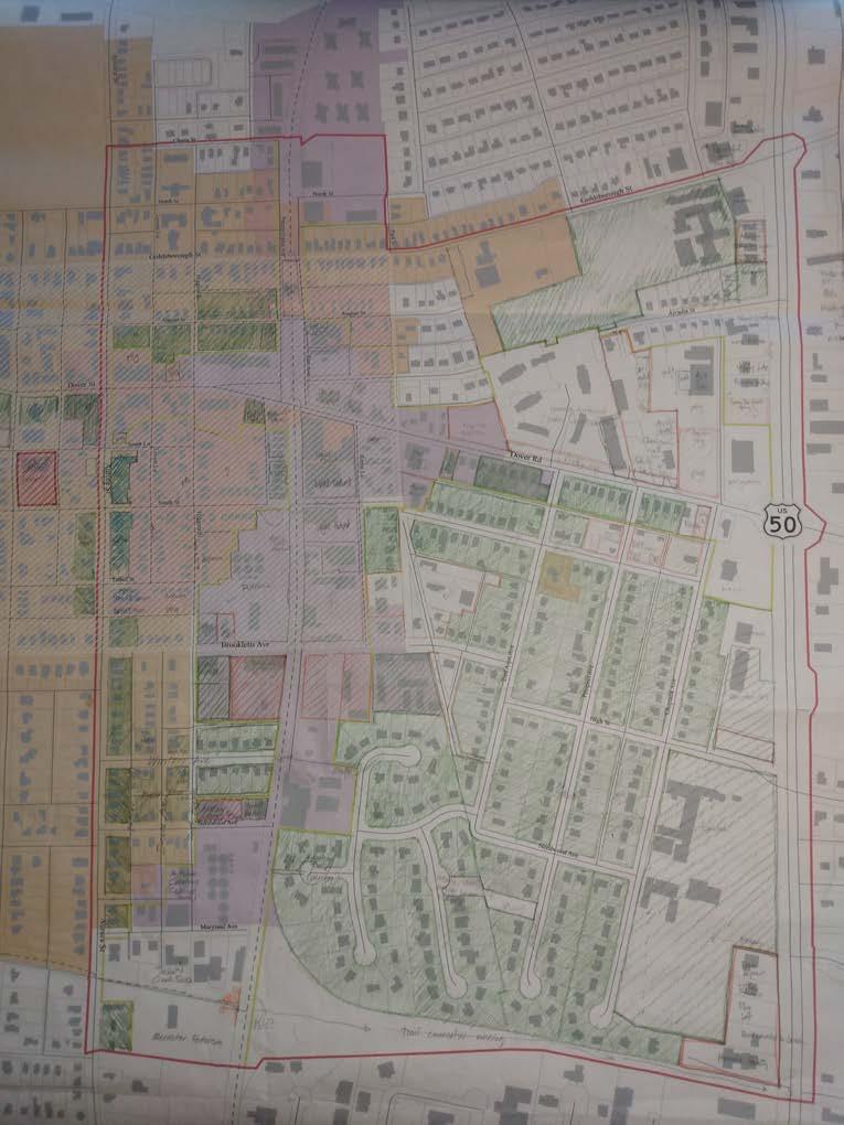
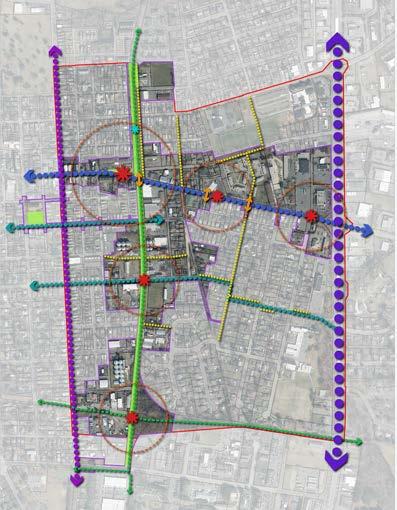
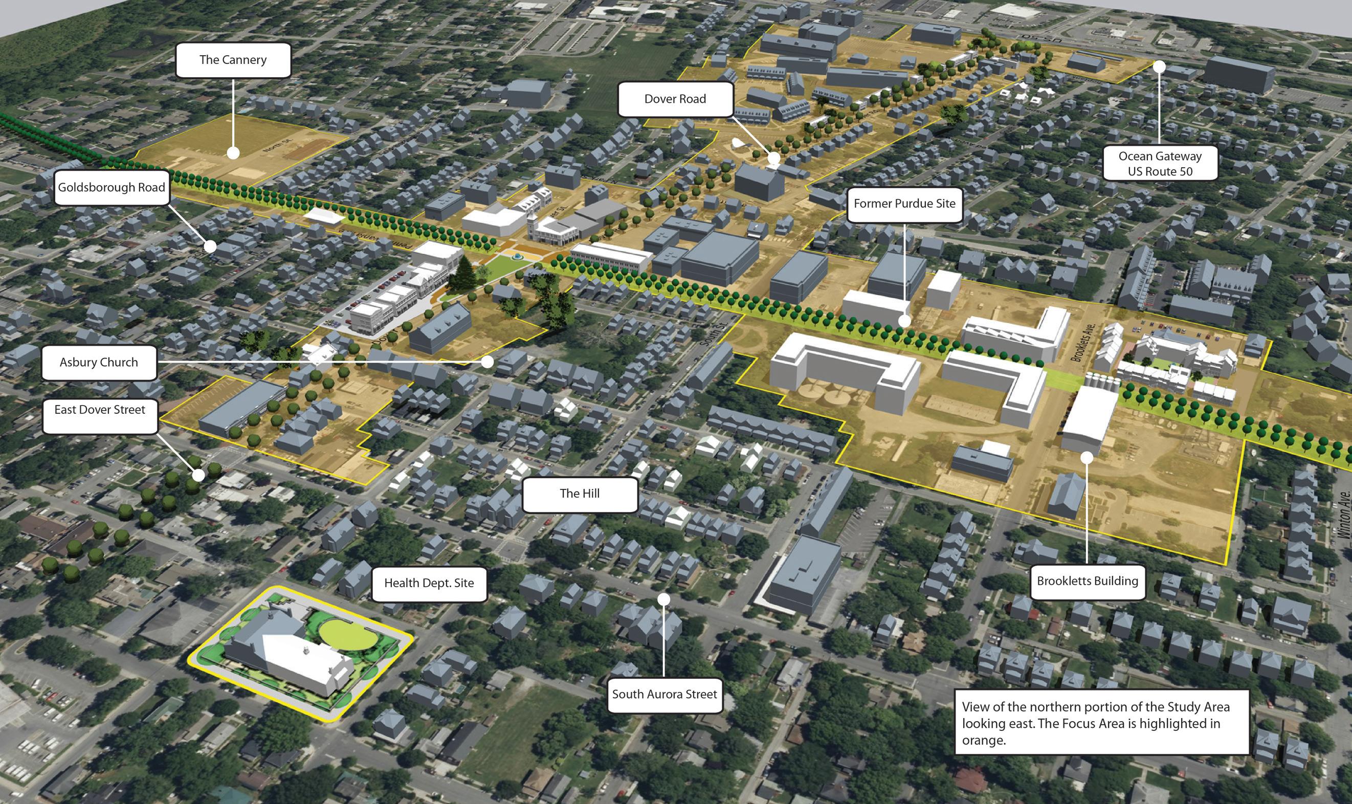
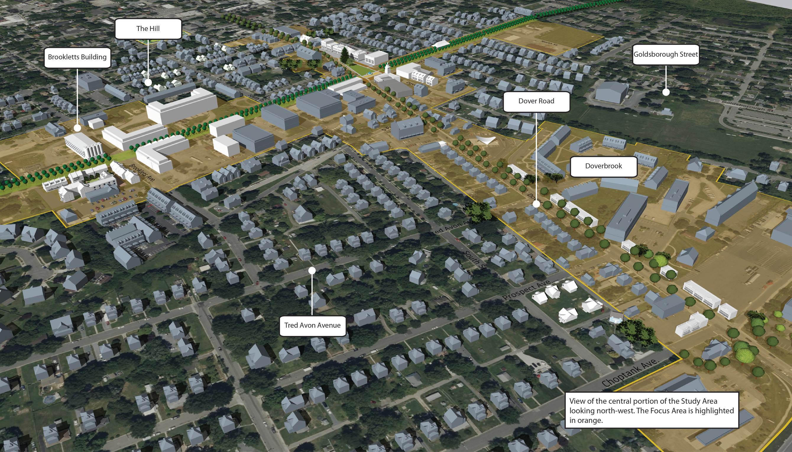
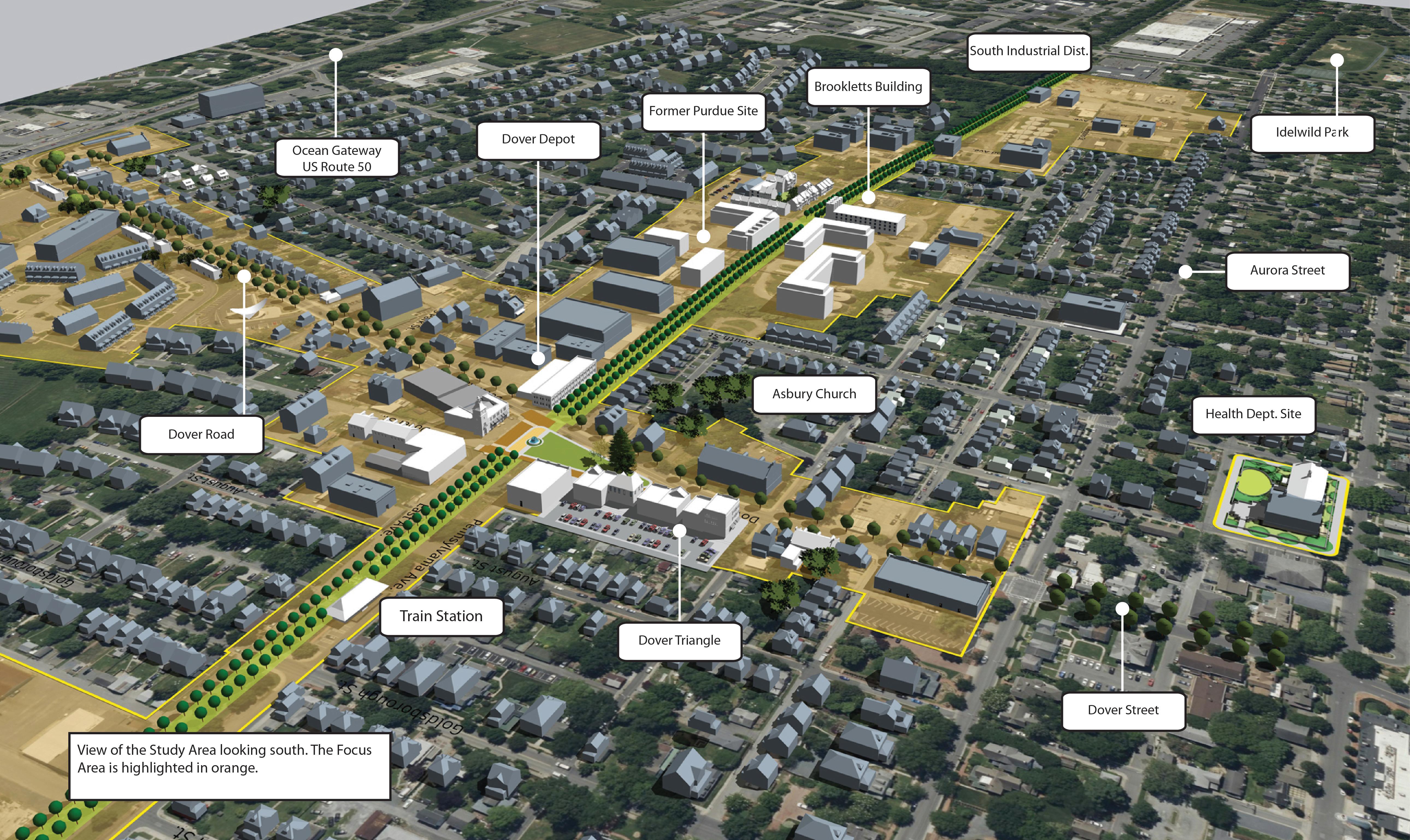
The Study Area boundaries for the Plan are approximately defined as Cherry and Goldsborough Street to the north, Aurora Street to the west, Idlewild Avenue to the south, and US Route 50 to the east. In addition to the overall Study Area, a number of Focus Areas were identified for more specific and detailed attention during the interactive Charrette phase of the process.
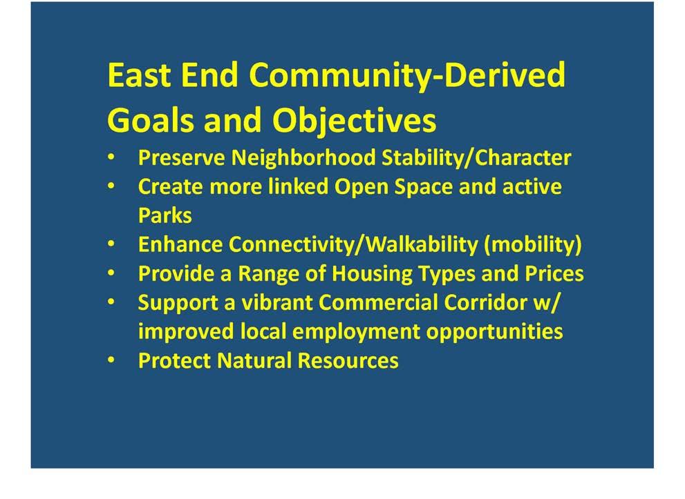
Key Objectives outlined by the Town for this process were to:
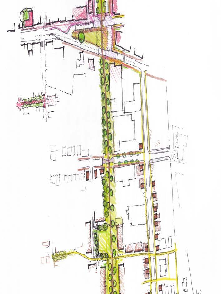
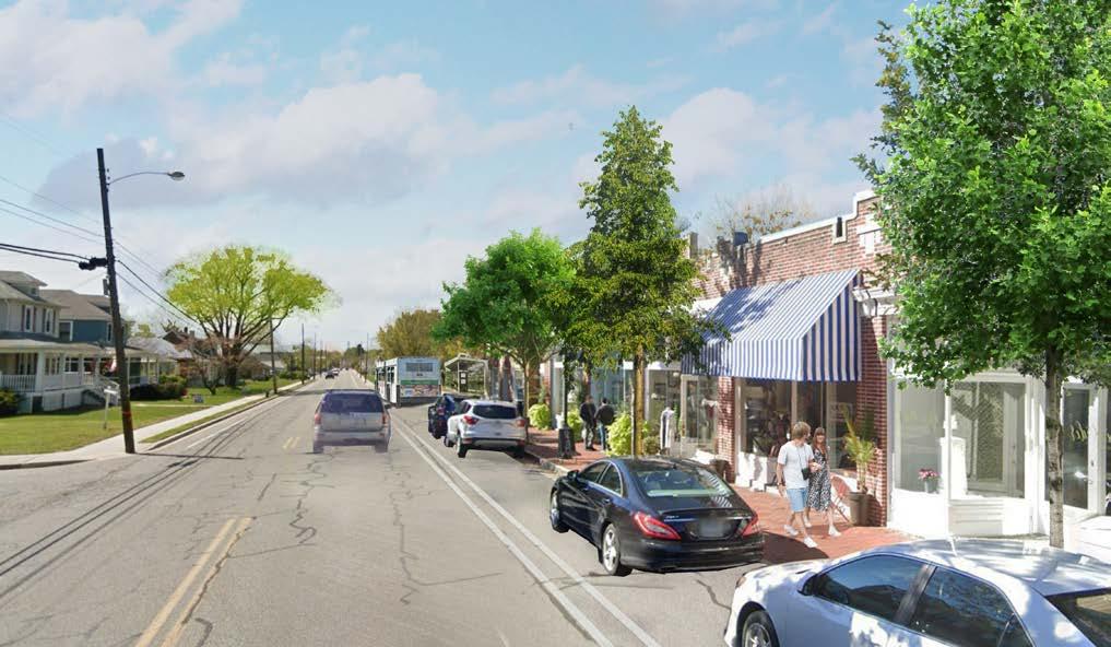
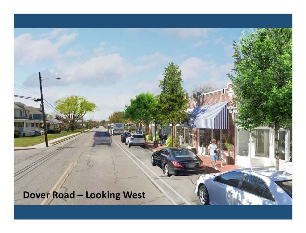
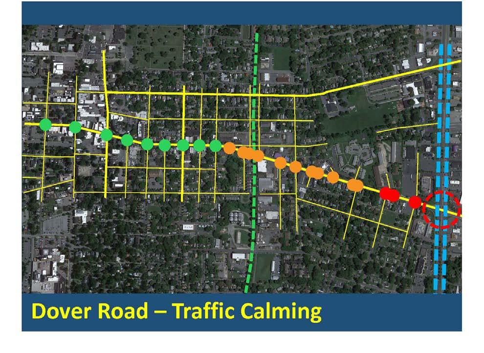
• Establish Dover Street as an inviting and vibrant corridor that supports innovative and resilient small businesses
• Identify the Dover Street corridor as a neighborhood and community destination
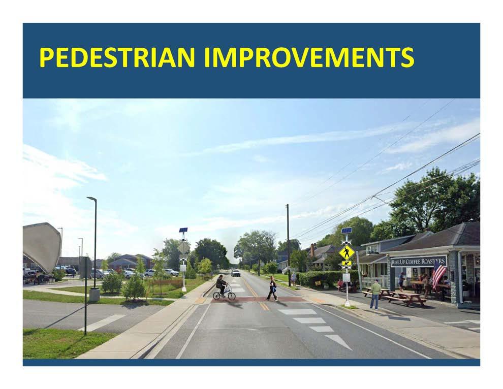
• Provide convenient and safe access for pedestrians and bicyclists along the corridor and from adjacent neighborhoods
• Build on the neighborhood’s existing and diverse population of residents by identifying redevelopment opportunities for legacy industrial properties associated with the Rails to Trails.
This Final Report details that process, its purpose and approach -- including an interactive, multi-day planning event referred to as a “Charrette,” its associated work products, and the Team’s findings and recommendations, as a result of that event and overall process.
General Approach and Process
The overall approach and 3-stage process was centered around the aforementioned interactive public-Charrette process, with a pre-Charrette phase, and a post-Charrette phase, which includes this final report.
The pre-Charrette phase involved general research and familiarity with the Study Area, including a compilation and summary of previous reports and studies relevant to the East End Small Area Plan process, including documentation of existing conditions, and a neighborhood walk-around with community representatives, to gather additional information and insights to be applied during the Charrette.
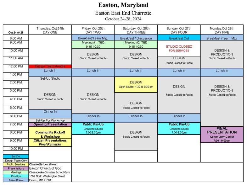
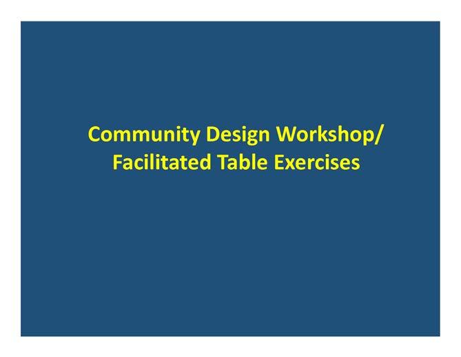
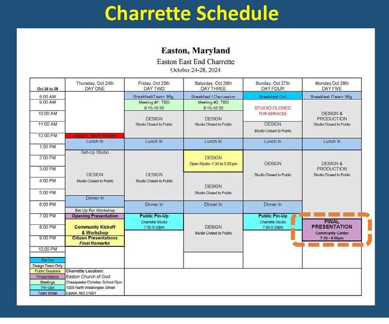
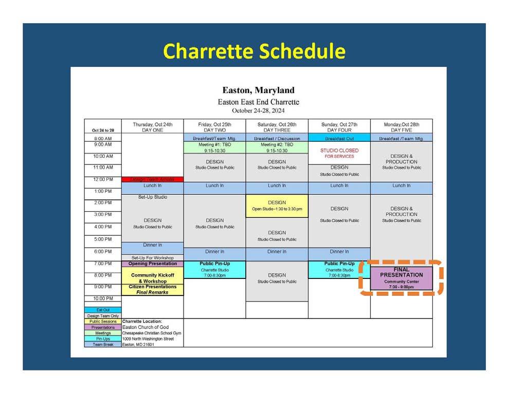
The Charrette itself was a four-day process, beginning with an opening night presentation and community design workshop, followed by interim pin-ups each day, showing incremental improvements to the plan, and a final presentation of the completed plan and work products.
Community feedback was solicited at each pin-up session, with comments and suggestions incorporated into each successive iteration, for community review and affirmation.
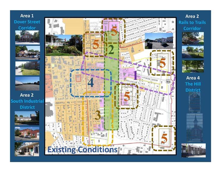
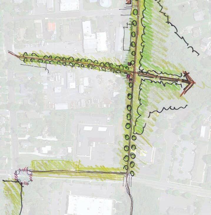
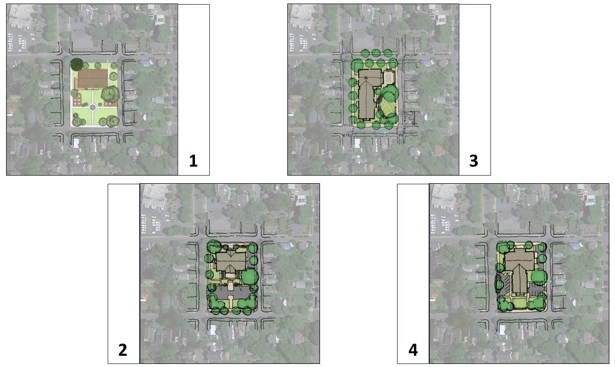
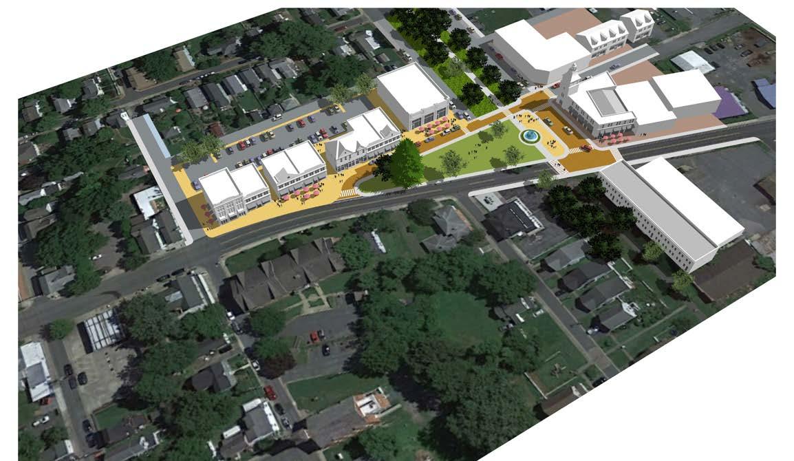
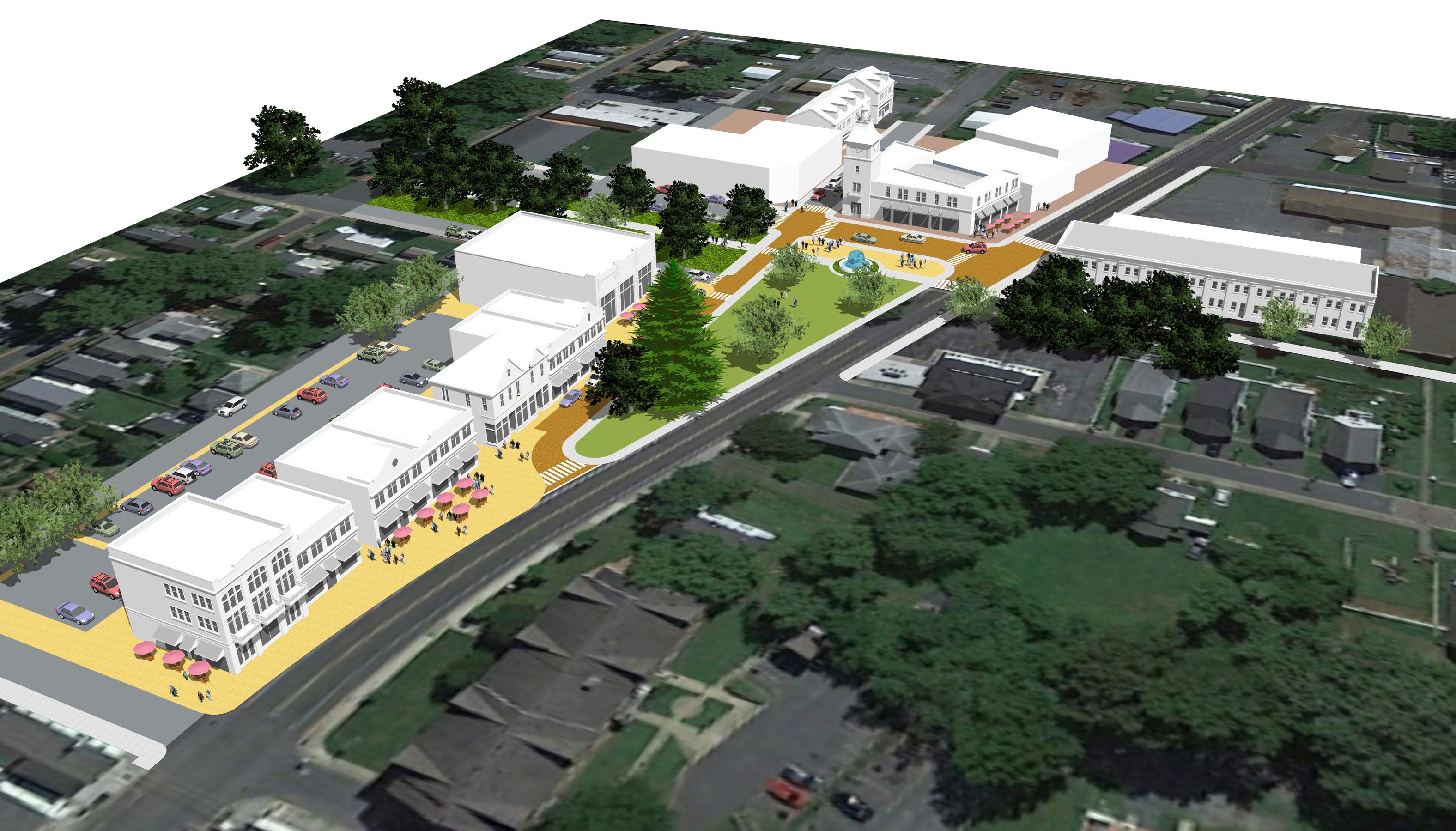
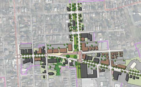
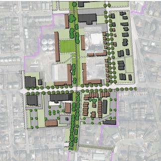
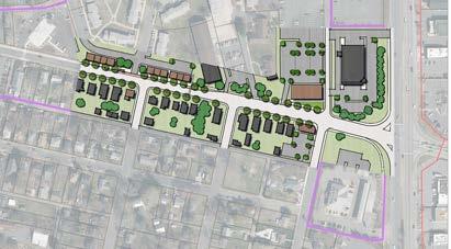
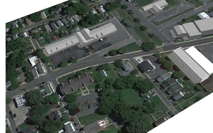
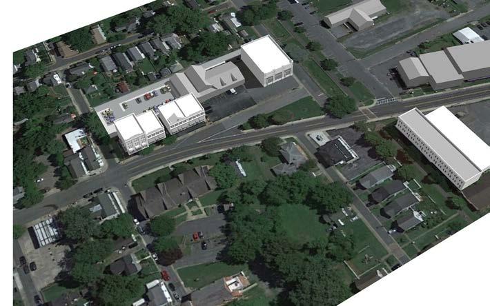
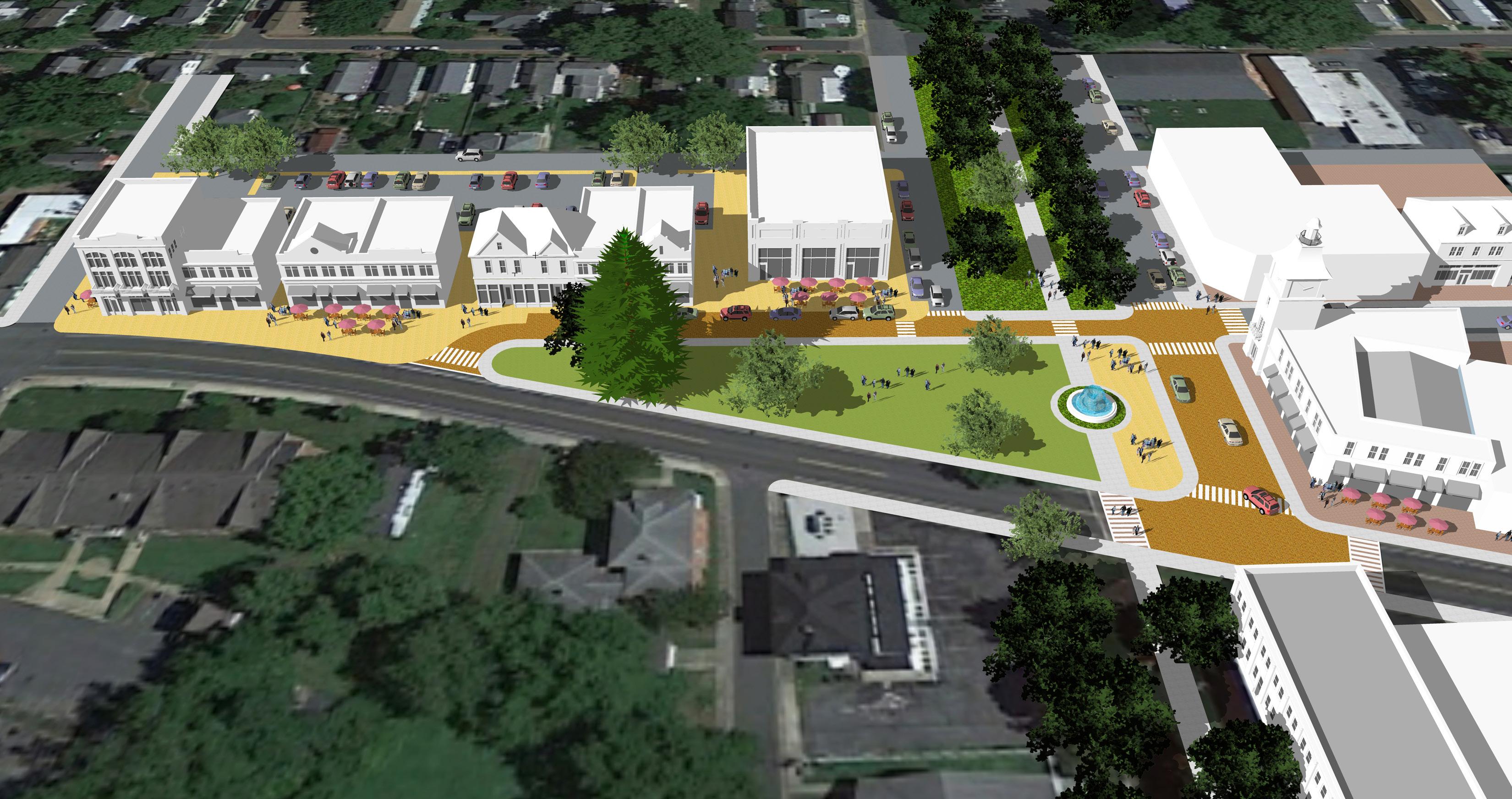
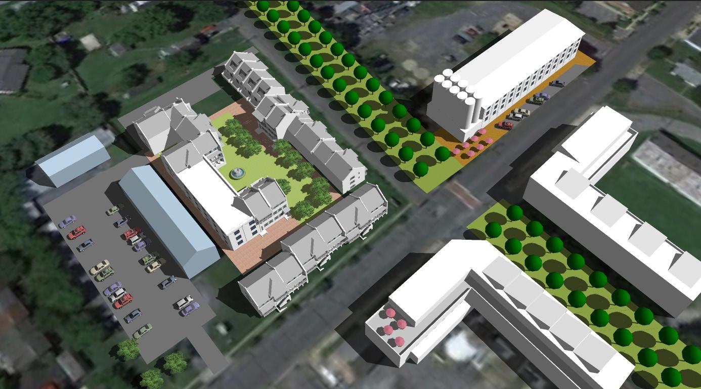
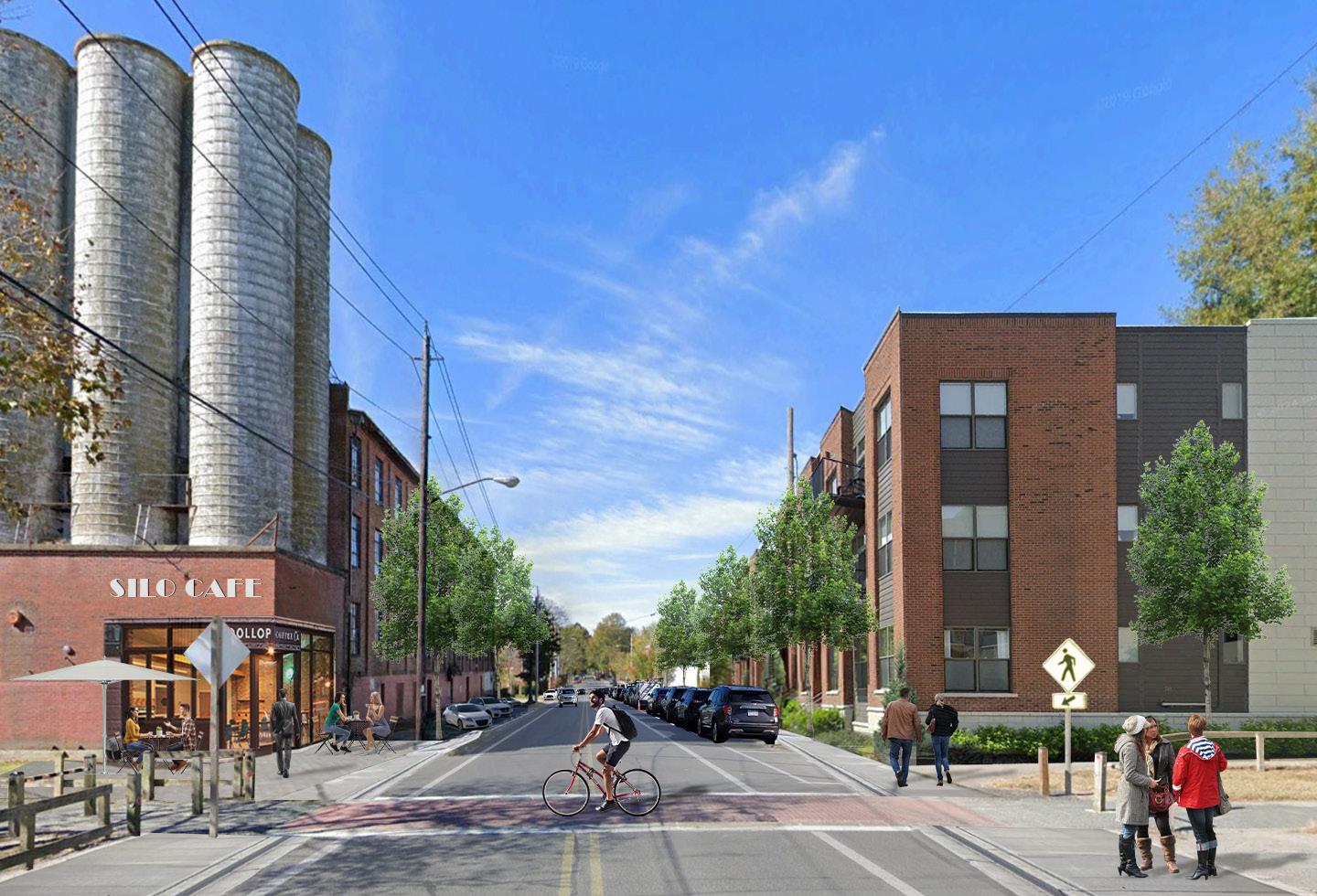
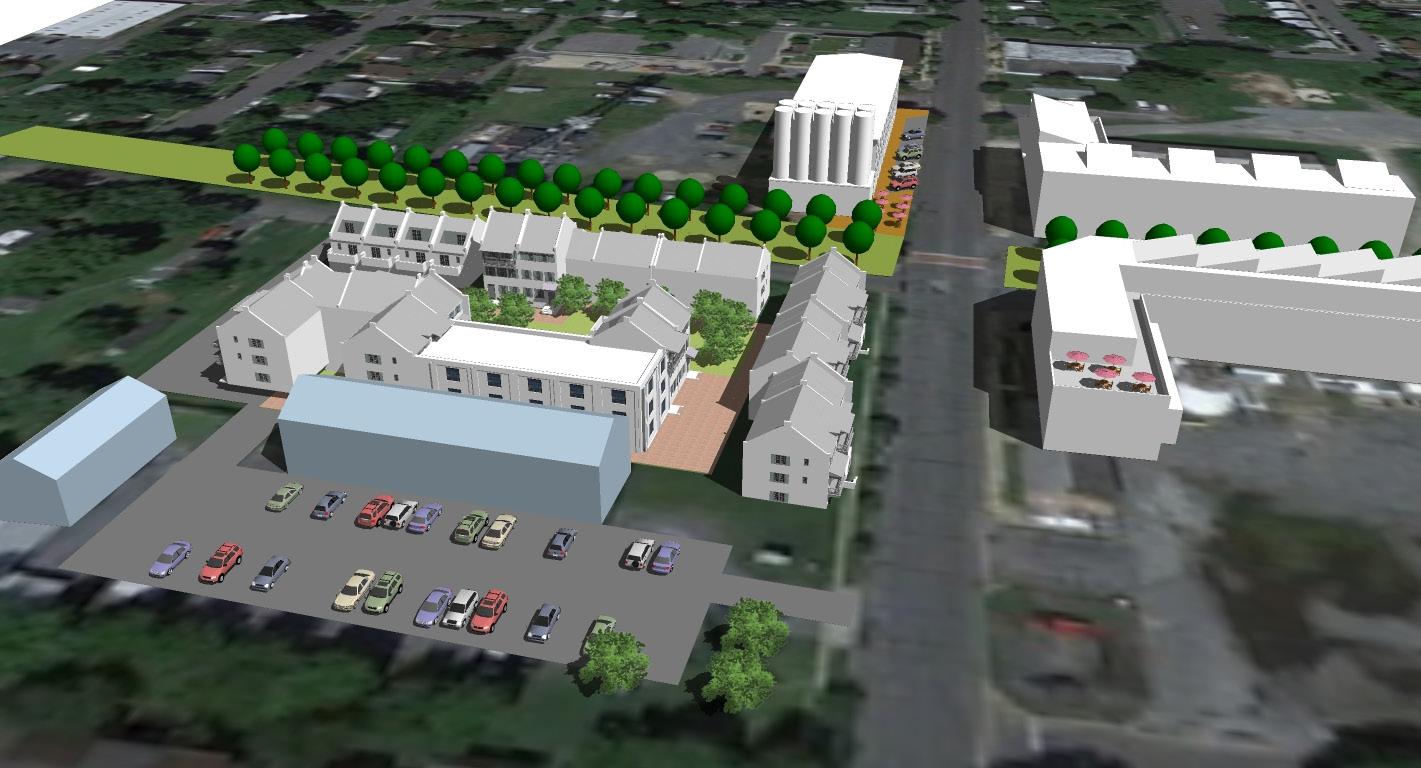
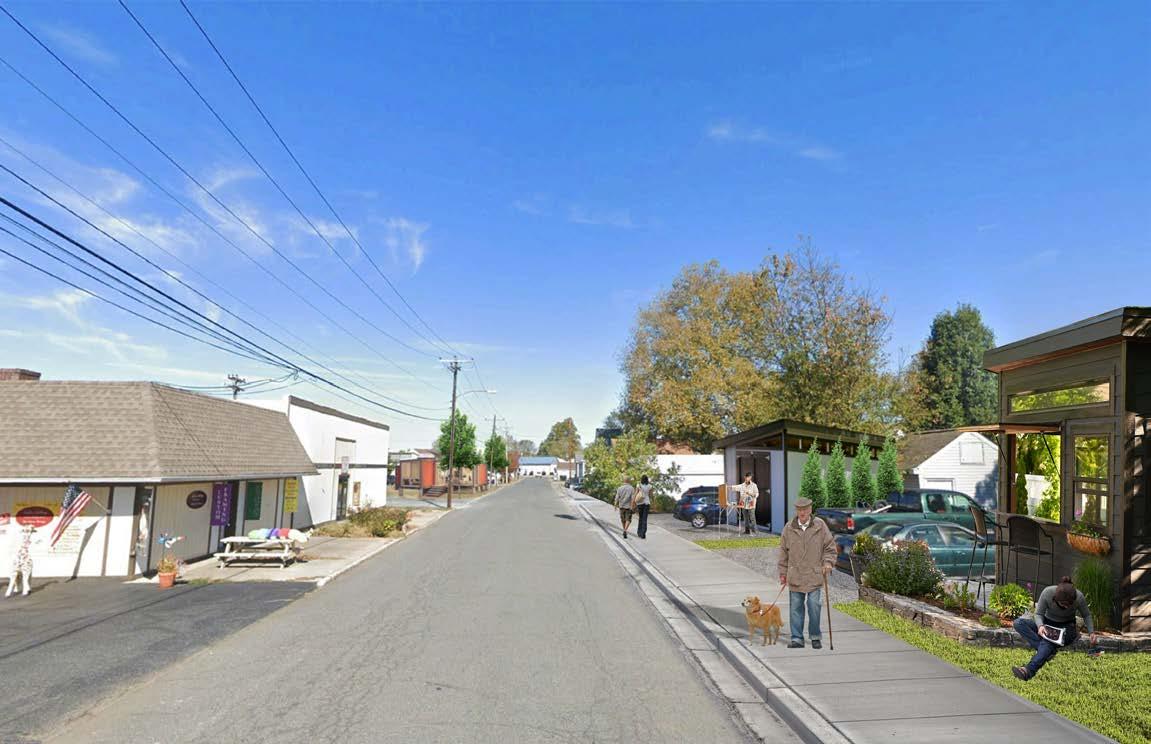
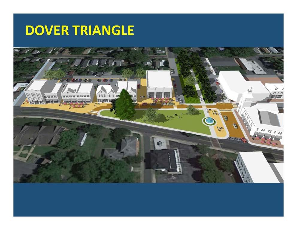
The Charrette produced an overall Framework Plan for the entire Study Area, with six detailed focus areas, showing both the larger context area, as well as the specific location of each of the designated focus areas within the East End. Each focus area was designed and drawn at a larger scale, showing more explicit detail, and accompanied by additional exhibits, including renderings, digital photo montages showing before-andafter conditions, and 3-D digital models. A video of the principle public open space, known as the Dover Triangle, was also created.
Summary Findings and Recommendaions
The Charrette process and its associated work products, underscored the policy objectives in the Town’s Comprehensive Plan.
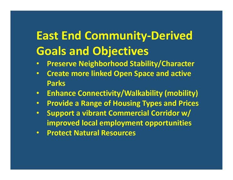
These included establishing Dover Street as a vibrant mixed-use commercial corridor, by continuing to build on the community’s diverse population, and by providing a range of housing types and price points, while also allowing for, and supporting, a variety of small-scale business enterprises, by improving pedestrian safety and connectivity throughout the Study Area, while maintaining the community’s unique charm and character
The East End is widely acknowledged to have “good bones.” However, both anecdotal observation and a formal market analysis, recently conducted and referenced in this Report, shows that the Town is still struggling to provide market-rate affordable housing to meet the demand in the area, and though the Town’s Zoning Code provides a number of tools intended to make it easier to meet that demand, many of the results on the ground to date suggest that not all of those expectations are being fully met.
The pre-Charrette analysis showed that while most of the Town’s regulatory and policy initiatives support the above outcomes, the existing regulatory framework does not specifically mandate it, as evidenced by several recent infill developments within the Study Area. Also, a study of the existing pedestrian network showed numerous examples of discontinuity, and missed opportunities for enhancing connectivity, in general, and pedestrian safety overall in specific circumstances.
Lastly, the Charrette formally documented continued broad public support for the existing policy framework outlined in the Comprehensive Plan update, and the strategic plan improvements proposed and illustrated during the Charrette process itself, as expressed through a series of iterative design and presentation pin-ups though which community
input was incorporated into the planning process, in real time, throughout the 4-day process.
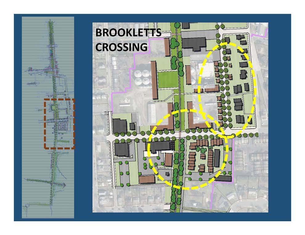
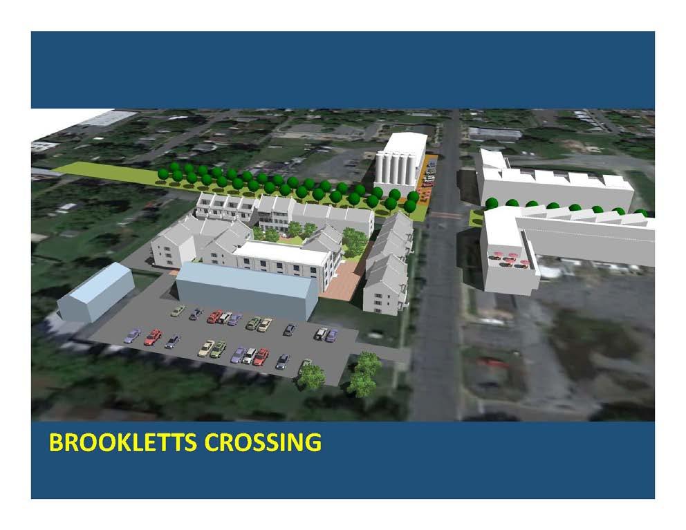
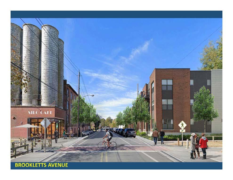
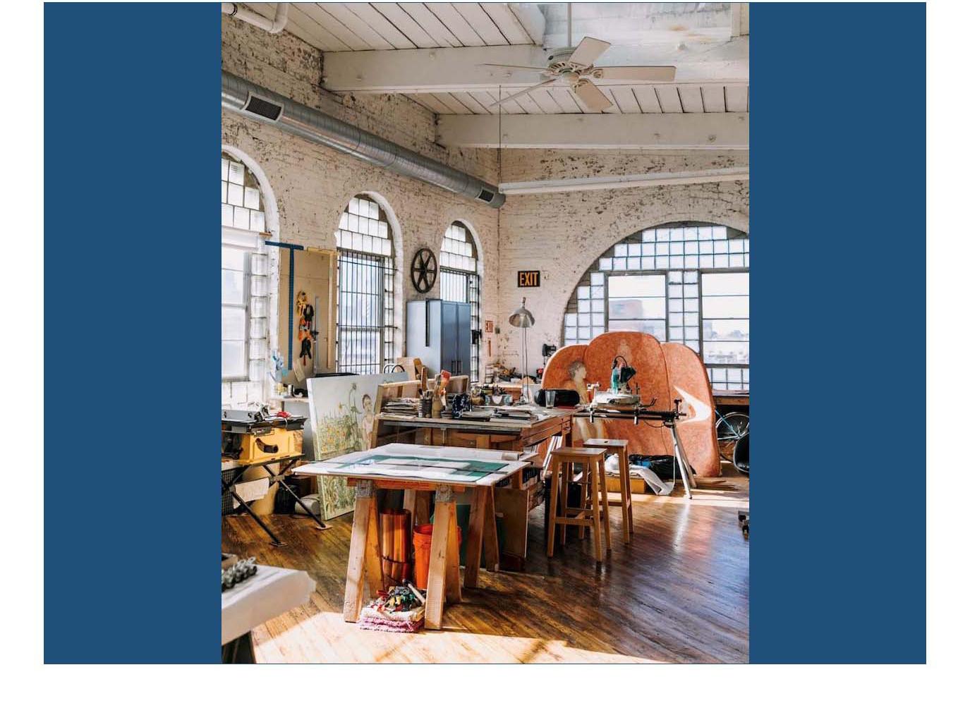
The report’s recommendations include tightening regulatory parameters to better and more consistently encourage the development of more “missing middle” housing types (missing middle being defined as those housing types between single-family on the lower end of the density spectrum, and large-scale multifamily on the other, which used to comprise a significant percentage of the housing units produced in prewar communities), as permitted and described in the Zoning Code and Comprehensive plan, as well as small-scale “work-live” commercial uses as an ancillary building type within and adjacent to, the Study Area’s historic industrial corridor lining both sides of the Rails-to-Trails greenway, and also for a proposed “Artist’s Village,” along Brookletts Avenue.
The Charrette also identified specific “catalytic” sites that are primed for redevelopment, providing illustrative examples and recommendations as to how those sites might be redeveloped based on the proposed policy-based improvements to the existing Zoning Code, along with improvements in pedestrian safety throughout the Study Area, with the intent of “bringing Downtown east,” along the Dover Street corridor, all the way to Route 50. And, by flagging potential locations for improved thoroughfare network connectivity utilizing existing street alignments and potential new street connections.
Lastly, the Charrette looked beyond the immediate boundaries of the Study Area to look at other opportunities and locations where it might be possible to apply some of the same public insights gained from the process to other sites proximate to, and within the Downtown itself, to create additional open space and recreational amenities for the larger Easton Community. These include the potential redevelopment of the Health Department site just to the west of the East End for a community center and neighborhood park, and/or to provide additional bike/ ped linkages to regional trail systems and natural features, south of the Study Area.
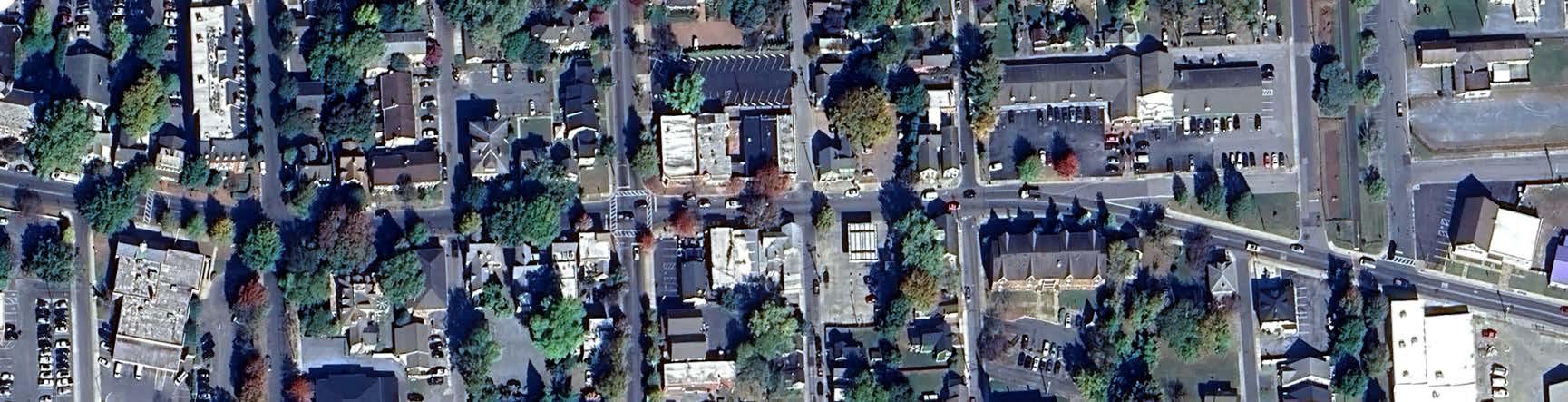
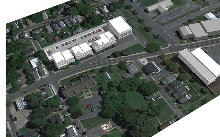
EASTON EAST END SMALL AREA PLAN STUDY AREA
GoldsboroughRoad
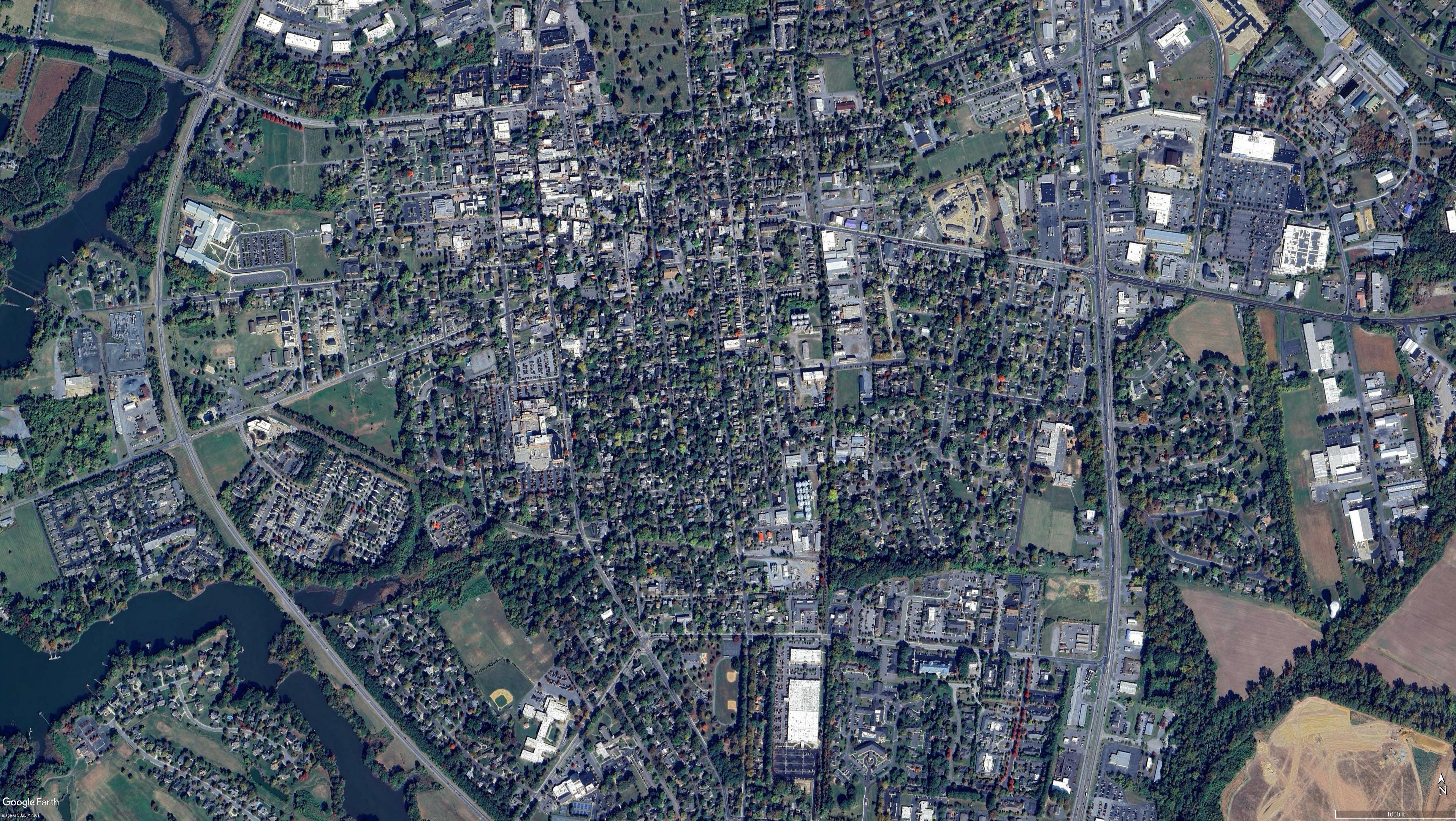
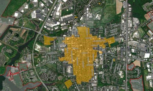
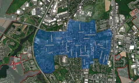
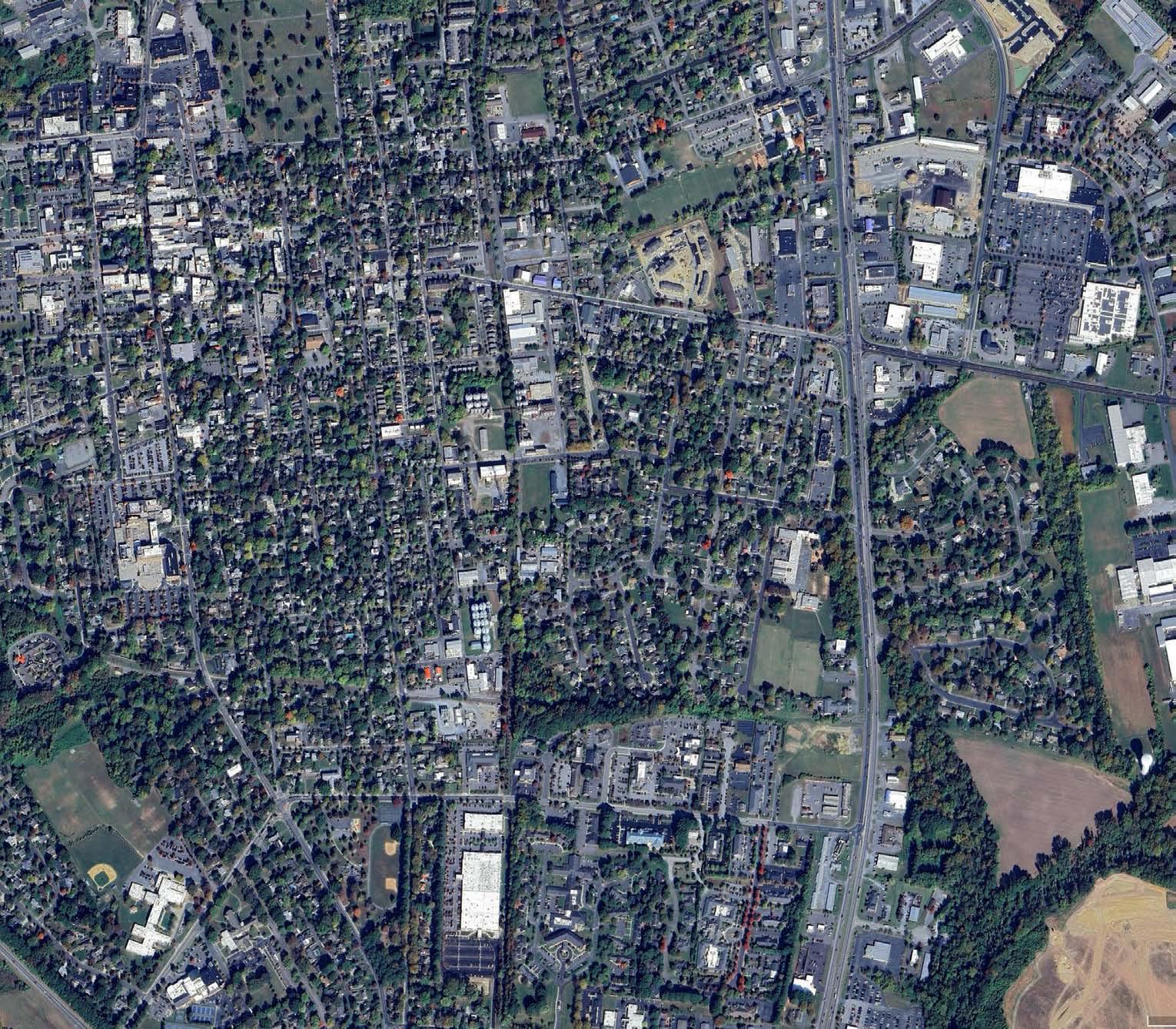
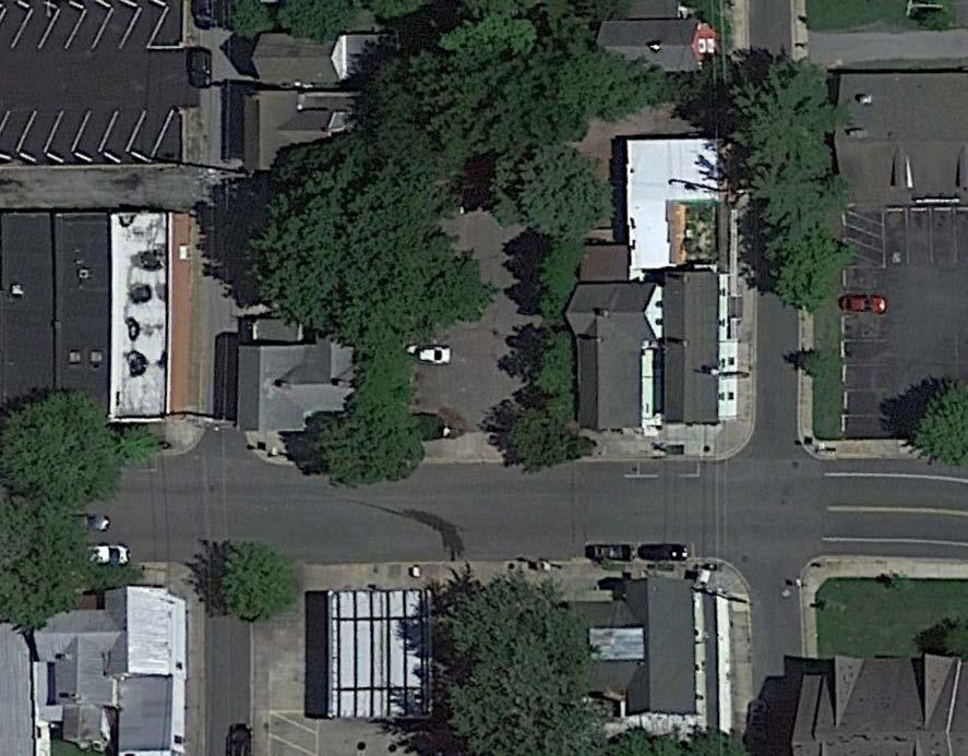
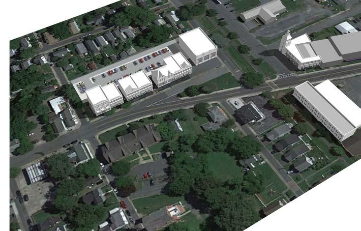
Figure 1. Satellite View of Downtown Easton and East End Study Area outlined in yellow (Source: Google Earth)
2.Background
A Brief History of Easton Easton was settled in the late 1600s. The frame meeting house of the Society of Friends was built between 1682 and 1684. The Town of Easton received its original beginning by an Act of the Assembly of the Province of Maryland dated November 4, 1710. This original village was known as Talbot Court House.
“On March 12, 1785, the Legislature passed an Act to erect the Town in Talbot County, and a Commission headed by Jeremiah Banning, was appointed to purchase land and “Lay it Out in the Best and most convenient manner into lots not exceeding one-half acre each”. This Act also authorized the Commission to survey the land and lay out the streets as well as name them. The name of the Town was to be known as “Talbot”. In 1788 another Act of the Legislature changed the name to “Easton”. It is not definitely known why this change was made. Some writers believe that the Town was first known as “East Town” or “East Capital”, as it was the seat of State Government of the Eastern Shore and from this later became Easton.”
Easton has been powered with electricity since 1887. Prior to 1906, Easton was a village of unpaved roads with plank crossings at the intersections. In 1912, major streets were paved. In 1914 the Town began operation of the water plant. In 1922 the Town constructed the gas plant. Easton was the first municipality in the State of Maryland to use a lagoon system as a means of sewage treatment. The limits of this early town was centered on the courthouse, the Washington Street corridor. The Town was generally west of the railroad line. Dover Road was the major east-west route.
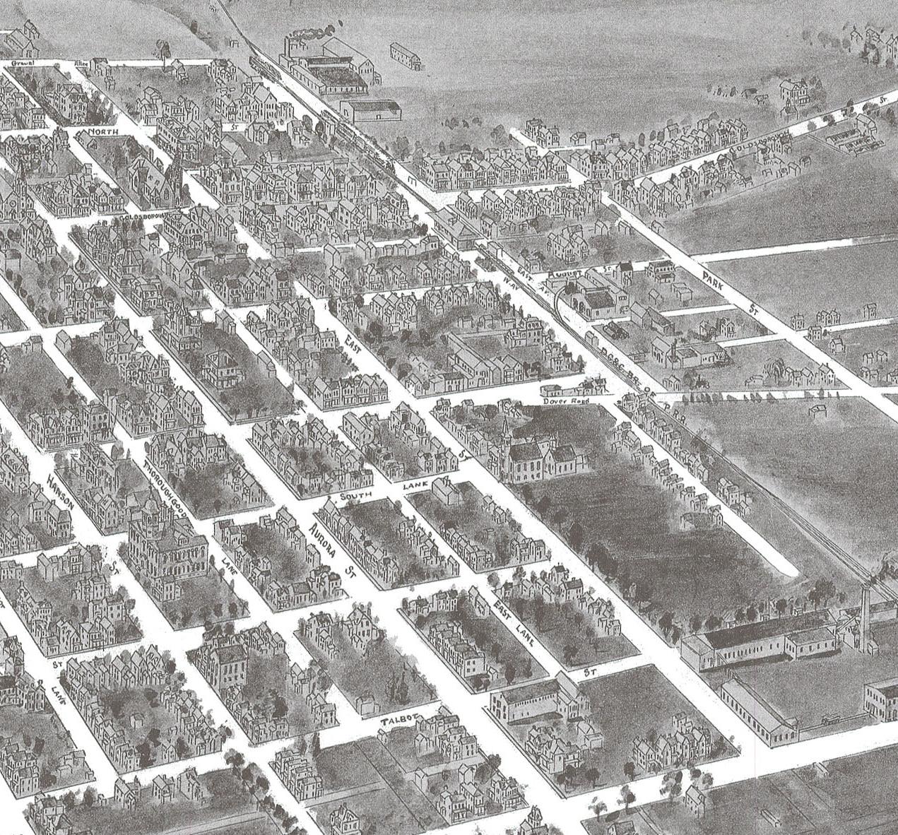
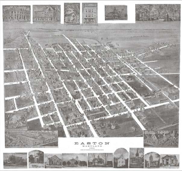
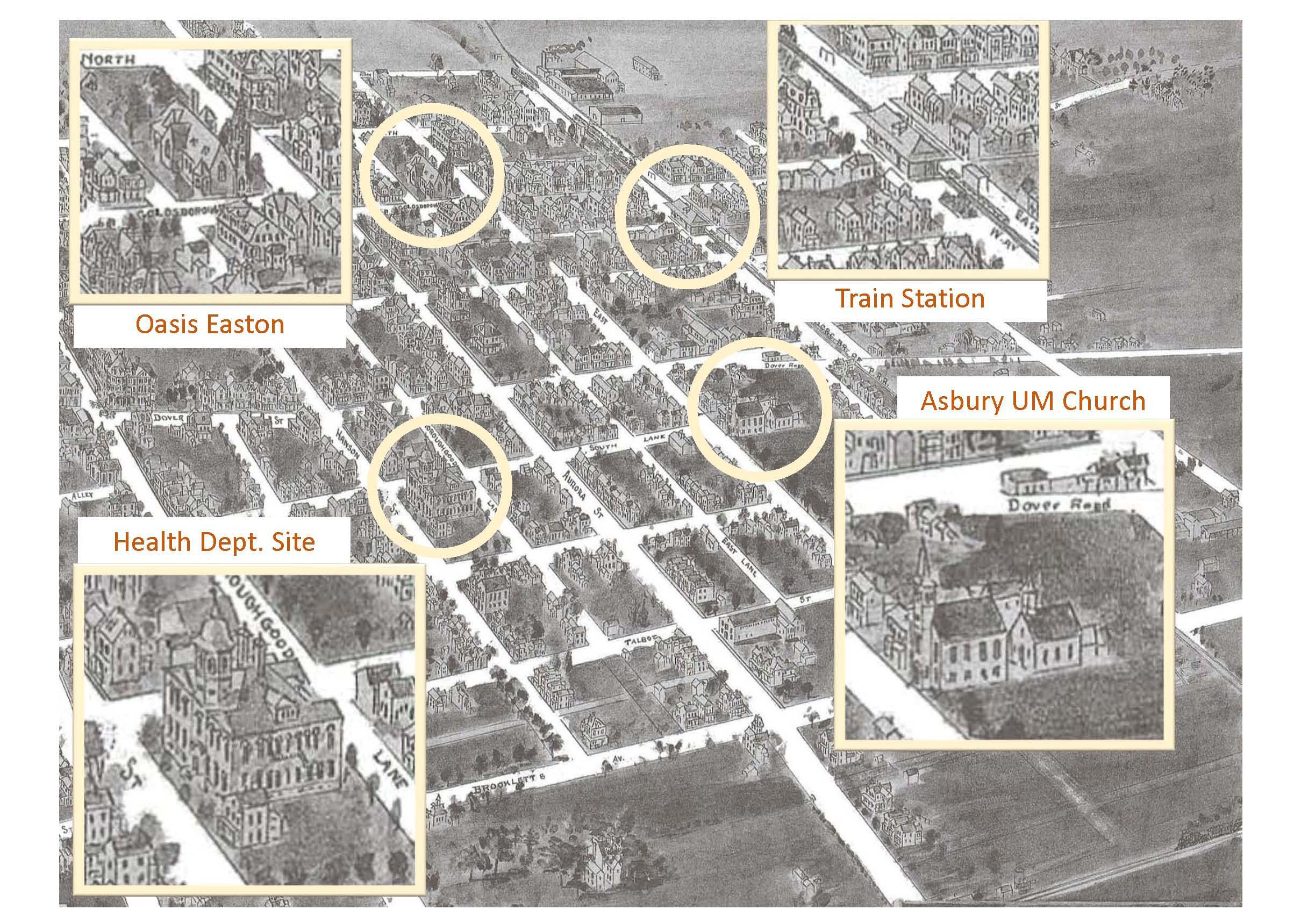
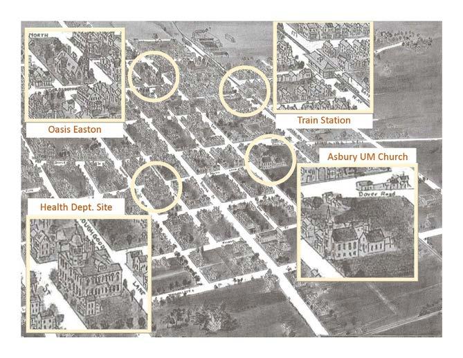
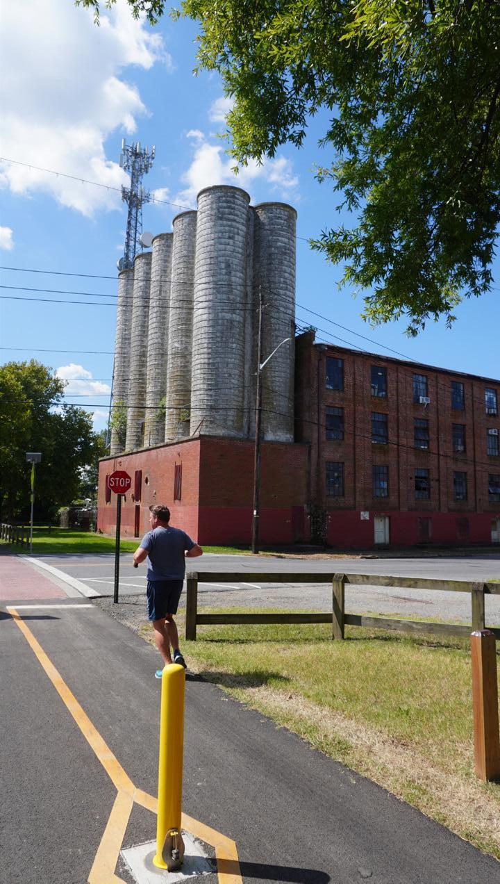
By the 1900s, the Town had expanded. Much of the new development to the east included several major industries located along the rail line and housing for workers of these various industries. This 1908 map shows many images of the factories and the general extent of the town.
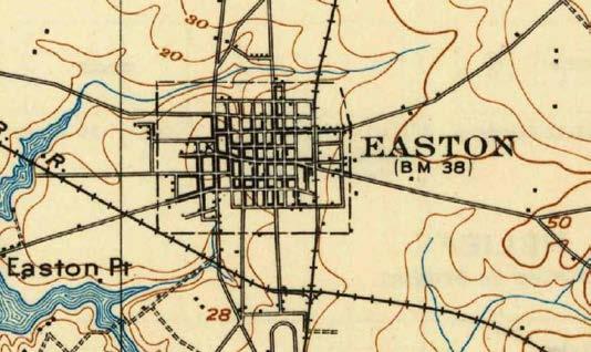
The 1904 USGS Map of St. Michaels shows the same extent in plan.
Easton became a major industrial center due to the availability of gas and electrical power, as well as access to the regional rail lines. It was during this time of industrial growth that the ‘East End’ emerged as a major part of the Town and its economy.
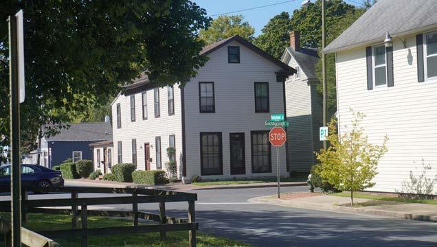
Easton’s East End
The East End may generally be described as the portion of the Town of Easton that emerged around the industrial district that was centered on the rail line. It can be loosely defined as that area from Aurora Street on the west, Goldsborough Street on the north, US Route 50 to the east, and with a southern boundary that generally follows Idlewild Avenue.
The Study Area
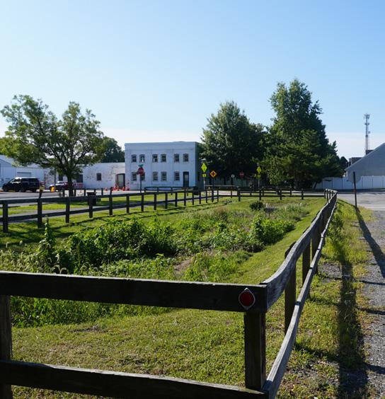
The Study Area identified by the Town of Easton for the Consultant Team encompasses much of the East End and includes some other peripheral areas. It is bounded by Cherry Street, Park Street and Goldsborough Street to the north, US Route 50 to the east, the east-west rails-to-trails corridor to the south, and Aurora Street to the west. The former Health Department site at the intersection of South Lane and Thurgood Street was also included in the Study Area. During the Charrette process, and based on feedback from the community, the Consultant Team suggested increases to the Study Area to include pedestrian and bicycle connections to Idlewild Park.
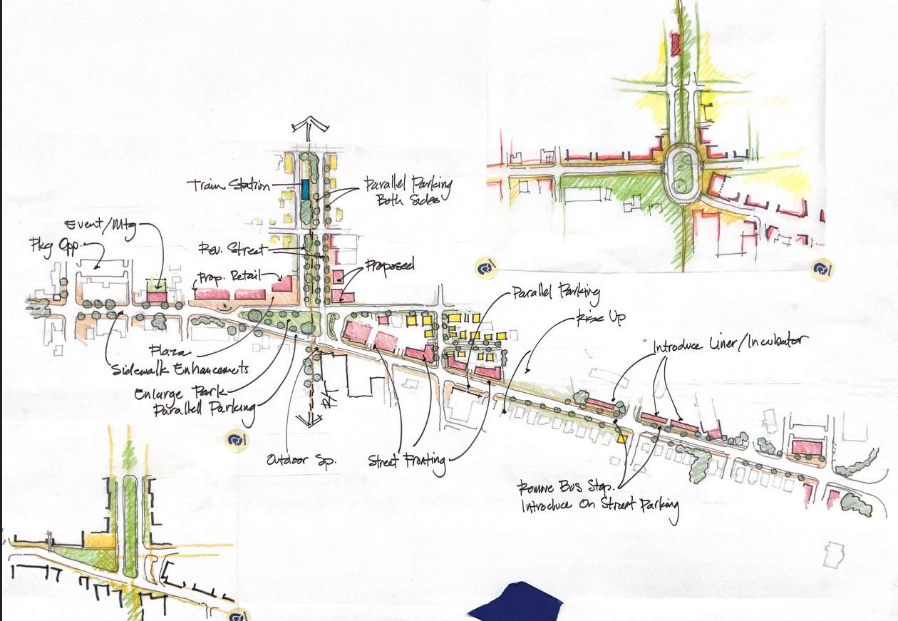
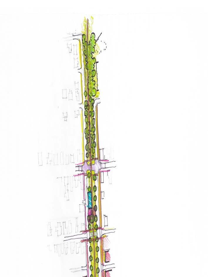
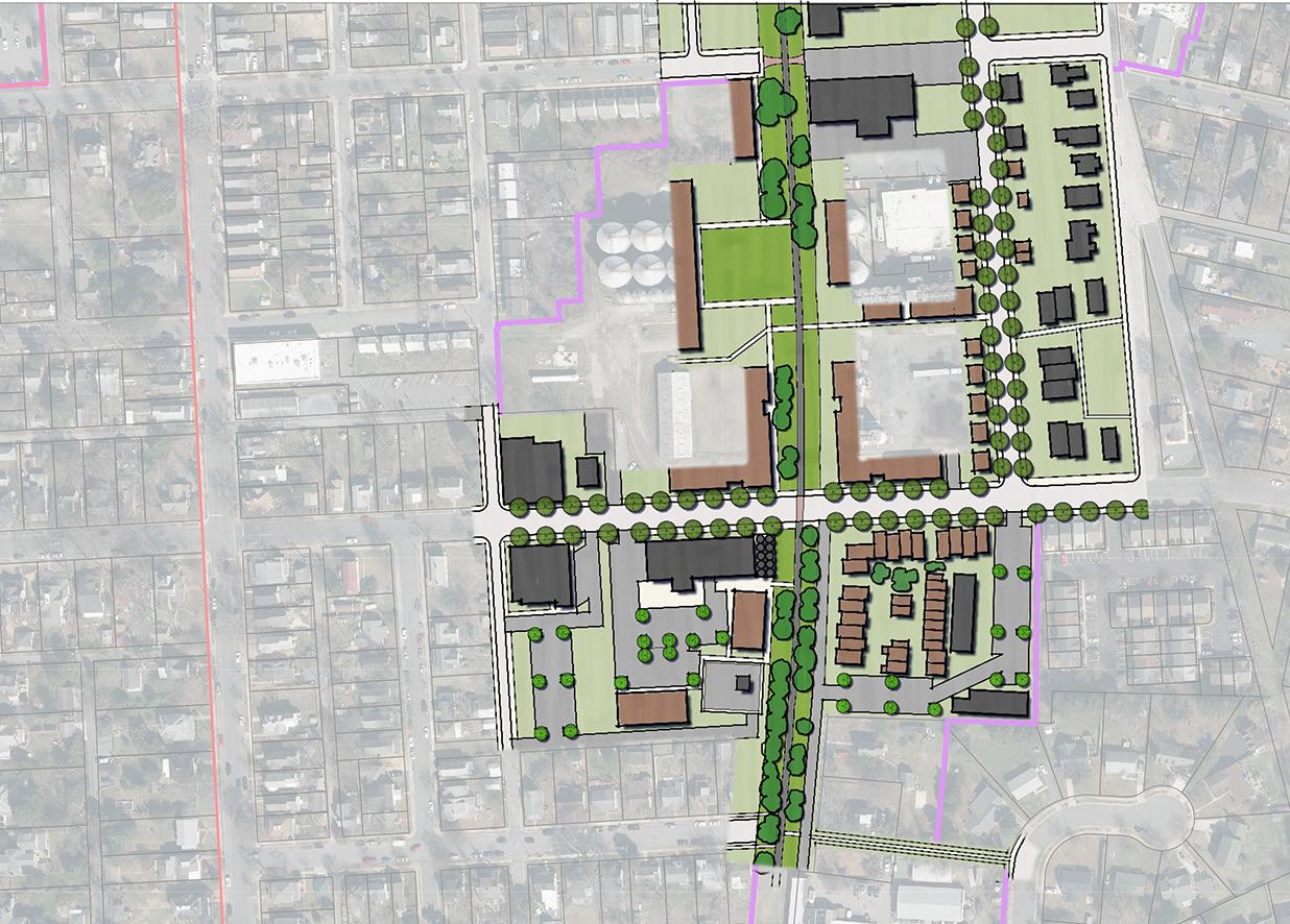
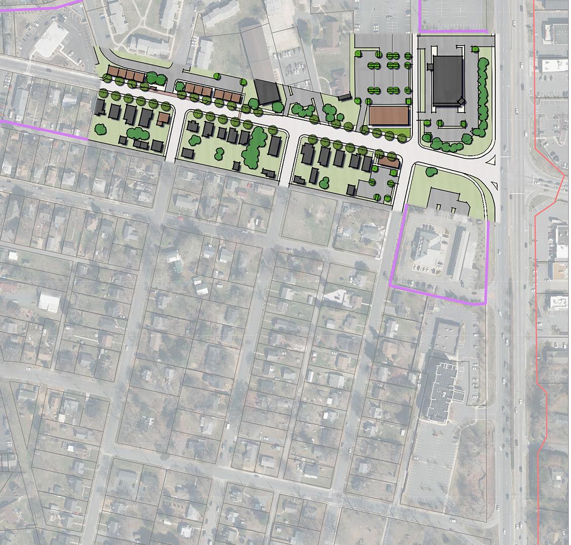
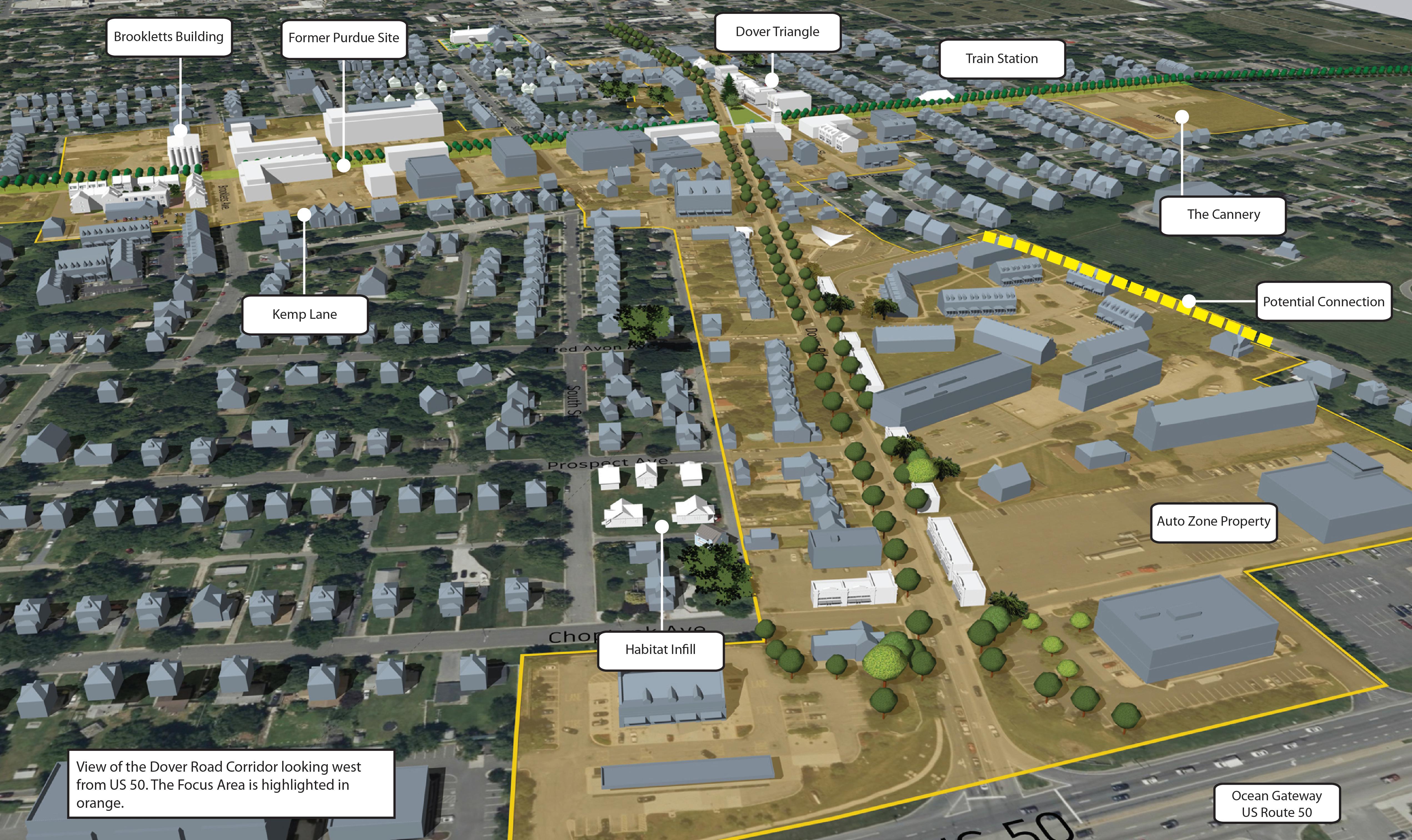
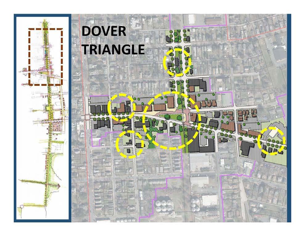
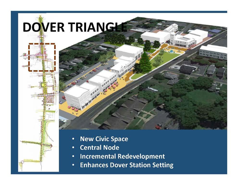
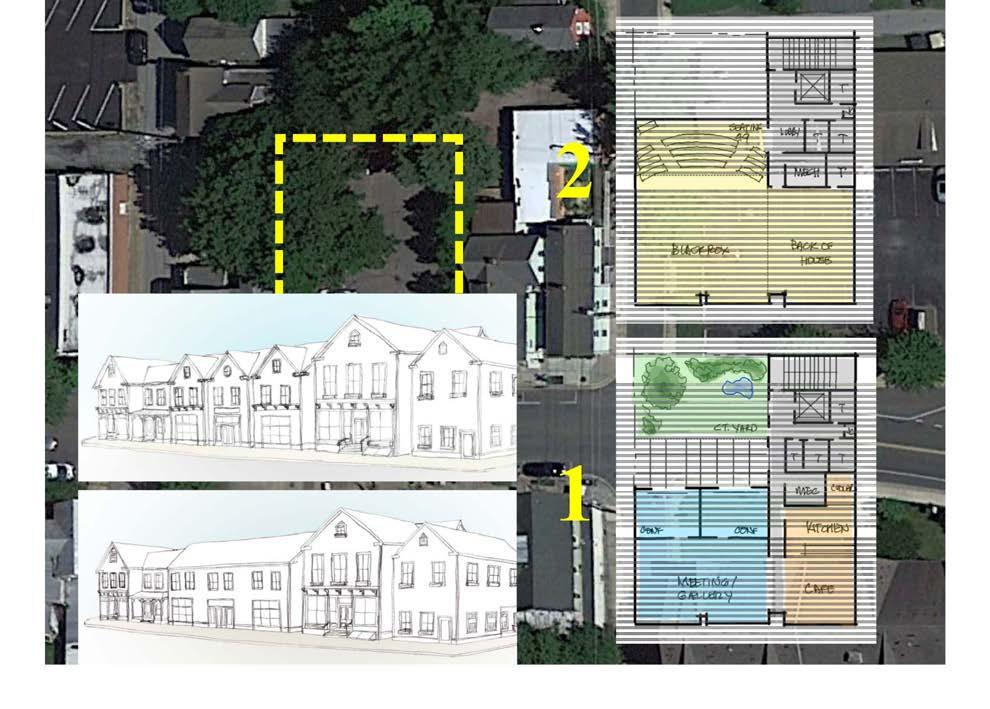
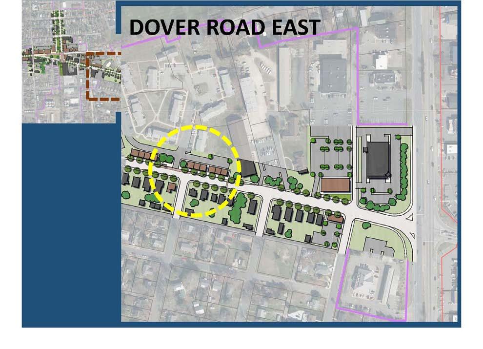
Special Focus Areas
Within the Study Area, the Town of Easton identified portions of the Study Area as Special Focus Areas. The Focus Area includes parcels and lots that generally front on the Do-ver Road/Street corridor and the Rails-to-Trails corridor.
Neighborhoods, Districts and Other Zones
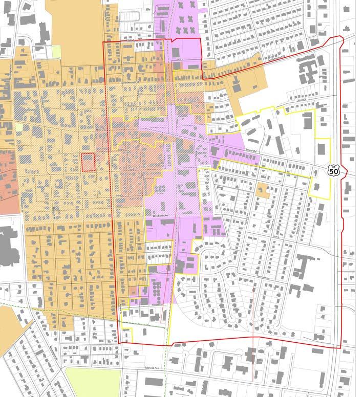
The Study Area includes many neighborhoods, districts and zones that influence and guide planning in the area. These include general land use and planning related, such as zoning districts, historic preservation districts and easements, the PUD Infill boundary, the Planned Redevelopment District (PRD), the Arts and Entertainment Tax Incentive District, and the Hill Community District.
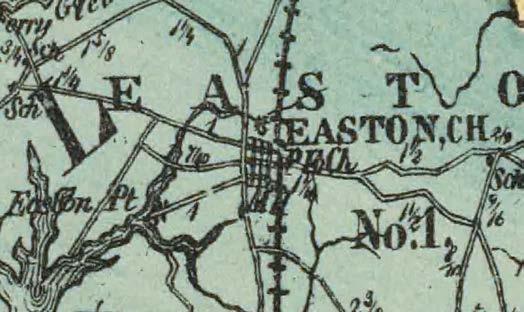
Figure 2. Excerpt from the Topographical Atlas of Maryland, published in 1873.
Figure 3. Excerpt from the 1904 USGS Map of St. Michaels.
Figure 4. View of Easton, Maryland, 1908.
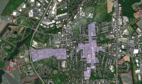
Figure 5. Easton’s East End Study Area, as modified by the Consultant Team.
The Easton Historic District
The Easton Historic District was established in 1980 and covers more than 900 structures in the center of Easton. The governing authority of the district is found in Article VI, Chapter 28 (Zoning) of the Code of Easton. The western portion of the Easton East End Study Area is partially within the Historic District.
PUD Infill Boundary
The PUD Infill area is intended to incentivize larger projects, promoting infill development and allowing flexible standards.
The Planned Redevelopment Overlay District
The Planned Redevelopment Overlay District (PR) is defined in Article V of Chapter 28 (Zoning) of the Town of Easton Code. Per the code, “[t]he purpose of the PR District is to provide a mechanism for the redevelopment, rehabilitation, and general improvement of certain older areas within the Town of Easton that have fallen into a somewhat neglected or dilapidated state or have simply been used for a purpose that no longer serves the health, safety or general welfare of the neighborhood.’
Maryland Incentive Zones
Many of the State of Maryland’s Incentive Zones are found in Easton. They include a Sustainable Community area, a Maryland Main Street Area, an Enterprise Zone, and an Arts and Entertainment District. Of these incentive zones, the Study Area is a part of the Sustainable community area and the Arts and Entertainment District.
The Arts and Entertainment
District
Maryland’s Arts and Entertainment Districts (A&E) are a part of the Maryland Department of Planning’s Reinvest Maryland strategy. A&Es help develop and promote community involvement, tourism, and revitalization through tax-related incentives. Easton’s A&E is one of 29 in the State of Maryland.
The goal of the A&E Districts program is to develop, promote, and support diverse artistic and cultural centers in communities across Maryland that preserve a sense of place, provide unique local experiences, attract tourism, and spur economic revitalization and neighborhood pride.
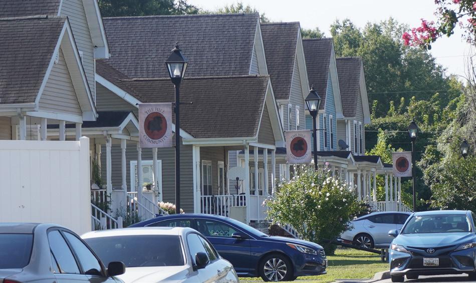
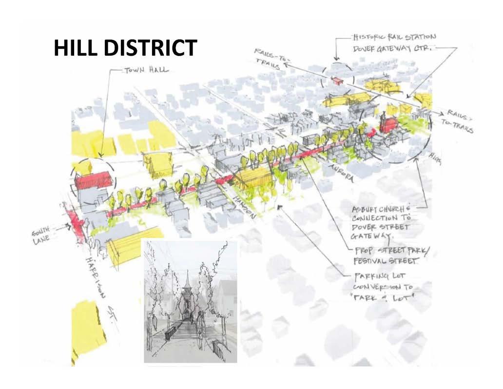
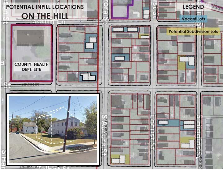
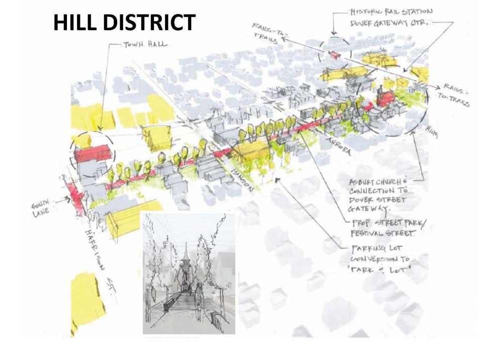
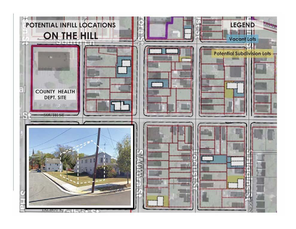
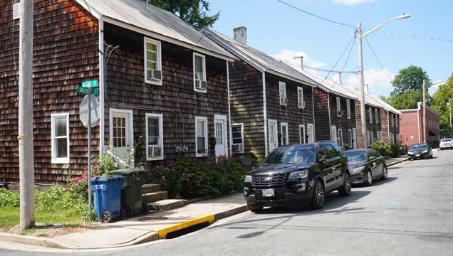
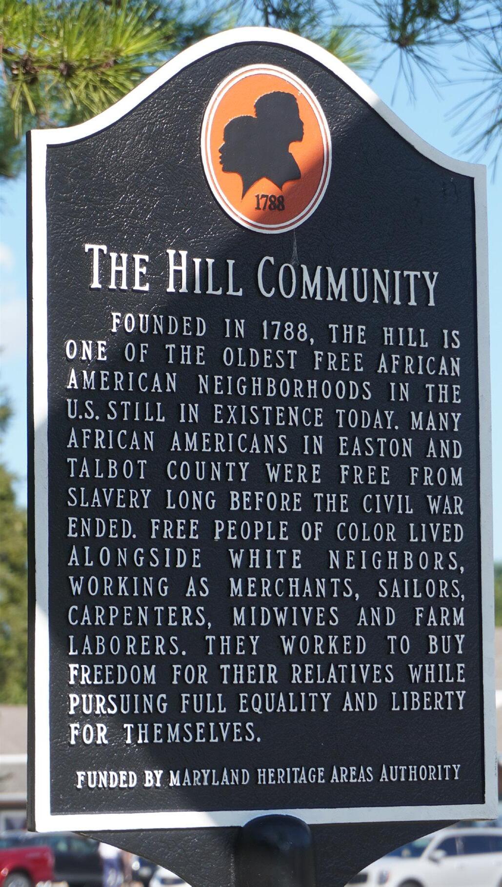
The Hill Community
The Hill Community is not only integral to Easton’s East End, it makes up a major portion of the Study Area and includes a large portion of the Special Focus Area. Generally, it is bounded on the north by Goldsborough Road, on the east by Park Street, on the south by Brookletts Avenue, and on the west by Washington Street. Approximately half of the Hill Community is within the Study Area.
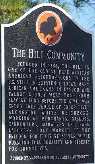
The Hill Community is one of the oldest free African-American settlements in the country. It is the oldest still in existence today. Its ongoing existence and enhancement is a major goal of the project.
This settlement thrived for over 70 years before slavery was abolished in Maryland in 1864, and for many years thereafter. In fact, Free Blacks lived in this area as far back as the 1670s. The first United States census of 1790 showed 410 free African-Americans living in The Hill, evidence of a very established community.
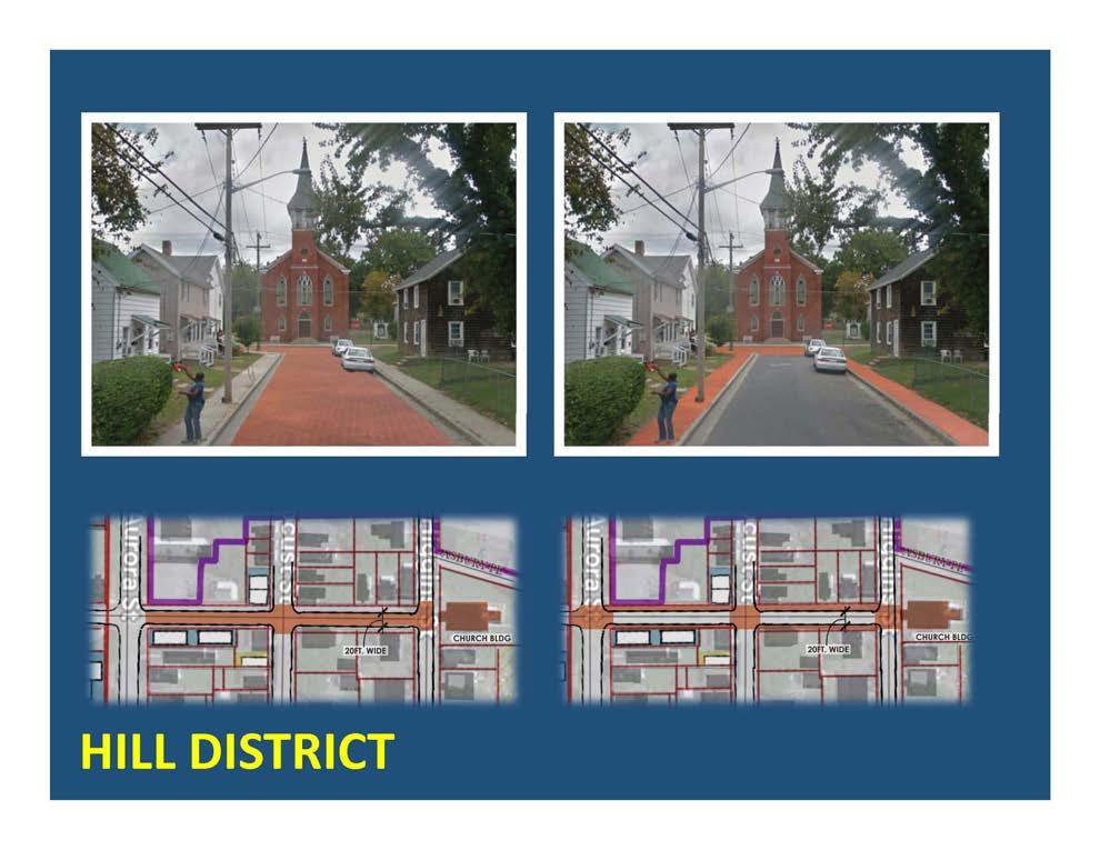
Frederick Douglass, the famed abolitionist and social reformer, was born just 12 miles from Easton, and played a major role in its early history and the spiritual and community life of The Hill. He consecrated the Asbury United Methodist Church, which terminates the eastern end of South Lane.
Morgan State University has provided important work regarding The Hill Community by researching its history, inventorying historic structures, researching members of the community, and providing visioning documents for improvements to the area. The Town of Easton has a program to renovate existing structures and to create new and affordable housing in The Hill, known as “Housing on the Hill”
Operation Frederick Douglass on The Hill is sponsored by the BaileyGroce Family Foundation. Its current mission is to promote the history of the Hill. The Foundation “envisions an African American Cultural Center in The Hill Community designed to tell the story of this extraordinary place and serve residents. It will be a safe place to gather, an incubator for businesses, a community resource, and a historical museum.”
Context – Town of Easton Comprehensive Plan
This planning effort is a part of the greater comprehensive plan for the Town of Easton. The Consultant Team is working as an adjunct to the Planning Director and his staff in the preparation of a Small Area Plan (SAP) for the East End area. The Charrette is a key stakeholder engagement and accelerated design process inside the context of the East End Small Area Plan. The Charrette process is described in more detail below.
Figure 6. Easton’s Historic District.
Figure 7. PUD Infill Boundary
Figure 8. Planned Redevelopment District
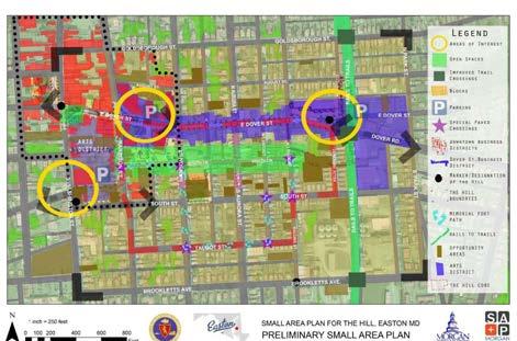
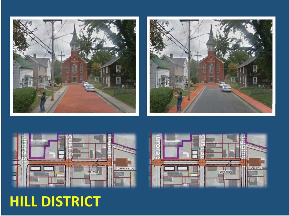
Figure 10. The Hill District. Analysis by students at Morgan State University.
Figure 9. The Arts and Entertainment District.
3. Existing Conditions
Introduction
The Existing Conditions Assessment Report for the Easton East End Planning Area was intended to provide a general overview of the study area sufficient to update and inform the then upcoming Citizen’s Design Workshop, which took place in late October, 2024, and as an information resource for residents, businesses, and local organizations interested in understanding the unique strengths and opportunities available to Easton, moving forward. This included a brief history of the Town and previous and current studies relevant to that effort, as well as a snap shot of current data and conditions, both positive and negative, at a level of detail and resolution consistent with the scope and focus of this process.
The report provides information on current land uses, zoning, existing and proposed infrastructure, green infrastructure, and public facilities; a description of community demographics and socioeconomic trends and conditions such as population, housing, employment, and economic development; and the identification and description of the area’s heritage resources.
Also, the report documents community needs, issues and concerns that may be addressed in the resulting Workshop Plan, based -- in part -- on results from the kick-off event held last October, one on-one interviews, the interactive map, and field visits, in addition to the interactive, publicparticipatory process (i.e., charrette) upon which this Final report is based.
Background/Previous Plans and Reports
The Town of Easton has a long history of pro-active community involvement in long-term planning initiatives. Relevant documents for summary review include the Comprehensive Plan (2010), The Hill Small Area Plan, East End Neighborhood Revitalization Plan (1997), the Easton Downtown Plan for Infill Development (2008), The Hill in Crisis Report (2010), and the East End Final Group Paper.
In summarizing previous plans and reports for the purposes of this document, the report will focus on general policies and recommendations specifically relevant and applicable to the East End Study Area.
2010 Comprehensive Plan
https://eastonmd.gov/186/Comprehensive-Plan
Introduction
Building on the Growth Management strategies of 2004 Plan and 2009 Plan updates, the 2010 Comprehensive Plan contains solid ideas concerning the future growth of the Town, limiting the ultimate geographic size of the Town, and improving the design of everything from neighborhoods to individual buildings.
These included twelve “visions,” as outlined below:
• A high quality of life based on sustainable principles;
• Public participation in community planning initiatives;
• Defined growth areas in or near existing serviced population centers;
• Community design based on compact, walkable, mixed–use, transitsupportive design consistent with existing community character and respectful of natural, cultural, and recreational resources, with --
• Sustainable infrastructure;
• Efficient transportation modes and networks;
• A range of housing densities, types, and sizes which provide residential options for citizens of all ages and incomes;
• Economic development that promotes employment opportunities for all income levels;
• Environmental protection of all land and water resources and natural systems;
• Resource conservation, including waterways, forests, agricultural areas, open space, and scenic areas;
• Public and private stewardship of both the built and natural environments;
• Comprehensive implementation strategies, policies, programs, and
funding to support these visions.
Land Use and Municipal Growth
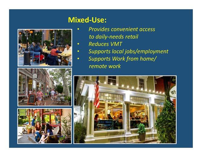
Land use is a key element of the Comprehensive Plan, with mixed-use was a recurring theme throughout -- particularly with regard to Community Character and the Transportation Elements.
The Plan identified benefits of mixed-use include:
• Increased housing options for a range of household needs and types.
• Providing more transportation options.
• Reduction in automobile dependence.
• Creating a more genuine “sense of place” than generic, single-use suburban-style development.
• Greater street-level activation throughout the day.
• More opportunity for social interaction.
• Reducing the community’s carbon footprint by encouraging walking and biking as a legitimate alternative transportation option.
A number of Specific Goals and Objectives were also identified, including:
• Envisioning new areas of the Town as an interconnected network of well-defined neighborhoods, each containing an integrated mix of residential, neighborhood-scale commercial, civic, and open space uses.
•
• Retrofitting existing subdivisions within the Town to allow greater flexibility for adding neighborhood-scale retail, and civic and open space elements to existing residential areas.
•
• Amending the Town’s Zoning Ordinance to change the focus from regulation by permitted land use, to building type and community impact.
•
• Continuing to improve the aesthetic quality of all aspects of development in the Town of Easton by refining the Design Standards, to ensure that Easton remains a special and unique place.
•
• Utilize the Town’s Forest Conservation ordinance and other resources to preserve existing habitat, and provide enhanced native landscaping along heavily traveled corridors.
•
• Revise use of the Special Exception review process to encourage wellconsidered design improvements as a condition of approval.
•
• Explore options for expediting approvals for permitted uses exhibiting extraordinary design excellence, and/or clearly stated policy goals.
•
• Develop an Urban Forestry Plan to expand the Town’s tree canopy, prioritizing native species.
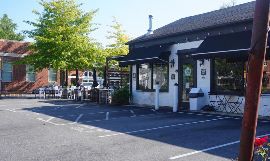
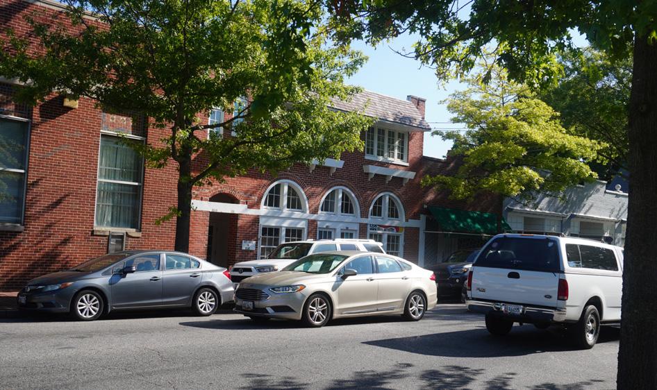
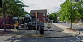
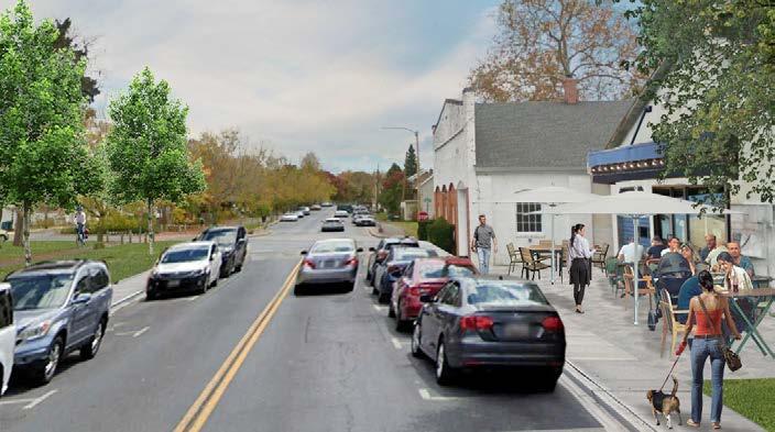
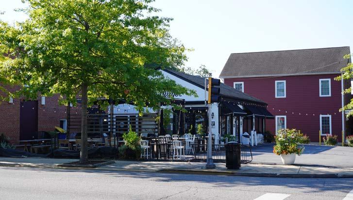
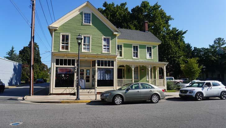
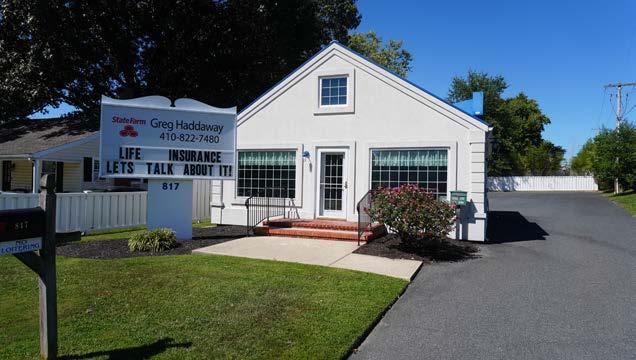
Figure 11. Rude Burger at the corner of East Dover Street and South Aurora Street. An example of Adaptive Re-use.
Figures 12 & 13. Landscape amenities and stormwater facilities along the Rail-to-trail.
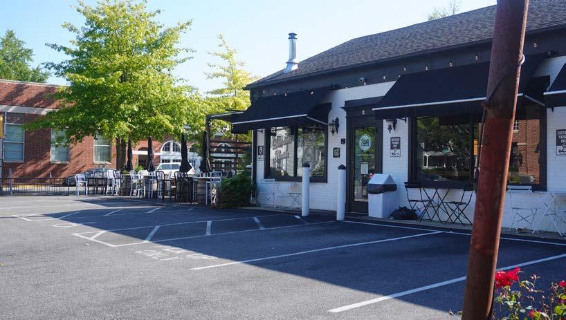
Figure 14. Historic building on Dover Road repurposed as multi-use facility including a brewery.
In addition to the above Land-use provisions, Municipal Growth was discussed in terms of prioritizing infill development within the serviced Town boundary, and prioritizing any additional growth within the larger Growth Boundary, subject to provision of adequate facilities and natural resources and critical areas protection -- and in an efficient and pleasing form that meets the policy needs of the larger community, with commercial development proportional only to that which the additional demand generated.
Community Character
Easton’s 2010 Comprehensive plan reference a number of archetypal rural small town development models, which could be distilled down to a simple set of planning and design principles:
First, they should reflect the building and settlement traditions of the region, in terms of building types and styles, in a range of sizes and mix of uses, compact and walkable as typical of many pre-War towns and villages in the region, and informed by local topography and natural features, such as forests, wetlands, and creeks.
Second, neighborhoods should connect, both to each other and to the larger town, as seamlessly as possible, and in increments of scale and configuration that match traditional neighborhood patterns based on a ¼ mile walking radius, with local parks, playgrounds, and greens spaces, and ready access to nature, and prioritizing infill development in serviced areas, over disconnected, greenfield sites.
Third, retail goods and services, should ideally be locally focused and conveniently accessible, in building types that fit into the physical and historical context of the town, in scale, massing, and design, specifically avoiding generic, cookie cutter, “big box” formats, and tailored more to fit the needs of smaller, locally independent merchants, and preferably located downtown.
Historic and Cultural Resources
The history of Easton’s historic buildings and neighborhoods date back over several centuries and provide physical reminders of early history and past events, and the lives of the people who experienced it.
Easton has a substantial and well-documented stock of historic struc-
tures, streetscapes, sites, and settings. Easton recognizes the importance of these resources, and that the preservation and rehabilitation of these structures and streetscapes enhances the historic character of the town, stabilizes neighborhoods, protects property values, and attracts visitors to Easton.
Preserving these historic buildings and structures includes consideration of their location and neighborhood context, architectural design, materials and workmanship.
One of the best ways to help preserve historic buildings is to find new uses for buildings which no longer able serve their original functions. Reasons for preserving historic structures include:
• Promotion of a strong sense of community pride and tradition;
• Community revitalization through the restoration and adaptive reuse of older structures;
• Increased property values and tax revenues as a result of renovation and restoration, and;
• Increased revenues from tourism activities generated by an interest in historic buildings and sites.
• New infill commercial and residential development and rehabilitation projects should be designed to complement historic buildings, and be compatible in scale, massing, detailing and style.
Specific Policy Goals include:
• Establishing a Local Tax Incentive program in Easton that encourages historic property owners to rehabilitate their property.
• Use historic resources to foster investment and economic development. Any new development which may impact historic resources is to be referred to the Historic District Commission for comment.
Housing
Easton’s 2010 Comprehensive Plan states that the most basic need of any community is housing. The key housing issues were generally
categorized as one of three problems: housing cost, housing quality, and housing availability, with all three assumed to be inter-related, to some extent.
While the private market caters to the housing needs of the more affluent consumers in the area, concerns were expressed regarding the increasing cost of housing in the area and its impact on younger buyers (starter homes), and those with lower to medium incomes (work-force housing), as well as the quality and availability of housing in the market in general, and strategies to address those concerns.
Two specific housing problems in Easton were highlighted: One was the lack of housing for individuals/families of low or extremely low income, with the recommendation that the Town should continue to expand its efforts to provide housing for this group, with The Housing Authority as the leading provider of this service.
The second aspect of housing identified as a problem in Easton is the availability of housing for the first time home buyer and the move-up home buyer, as newer subdivisions are primarily targeting the upper levels of the market, and this market segment was being underserved. Strategies discussed also included creating some form of Inclusionary Zoning, which would obligate developers to build a percentage of affordable housing as part of any proposed new development.
Specific Goals and Objectives mentioned include:
• Ensuring that housing in Easton is safe, sanitary, structurally sound and safeguards or upgrades neighborhood design.
• Establish design standards and require physical distribution of different housing types to provide both visual interest and a smooth blend of affordable housing in the community.
• Provide sufficient density to create a sense of place, use infrastructure efficiently, and creates pedestrian-friendly, transitsupportive neighborhoods.
• Provide open spaces; use landscaping to accentuate the natural environment and give visual connectivity; preserve natural assets, community identity and environmental and health standards.
• Increase the supply of low-income housing in the Town of Easton, by supporting the efforts of the Talbot Housing Authority to provide more home-ownership and rental opportunities for low-income individuals and families.
• Consider zoning amendments, including density bonuses, to encourage the development of new infill housing at a variety of pricepoints, including more apartments and the rehabilitation/adaptive reuse of existing and historic buildings, on vacant or under utilized land within areas currently served by adequate infrastructure and public facilities.
• Establish a Town-initiated self-help housing program.
Figures 16 & 17. New Infill housing in the Hill Community and The Hill Community commemorative historical marker.
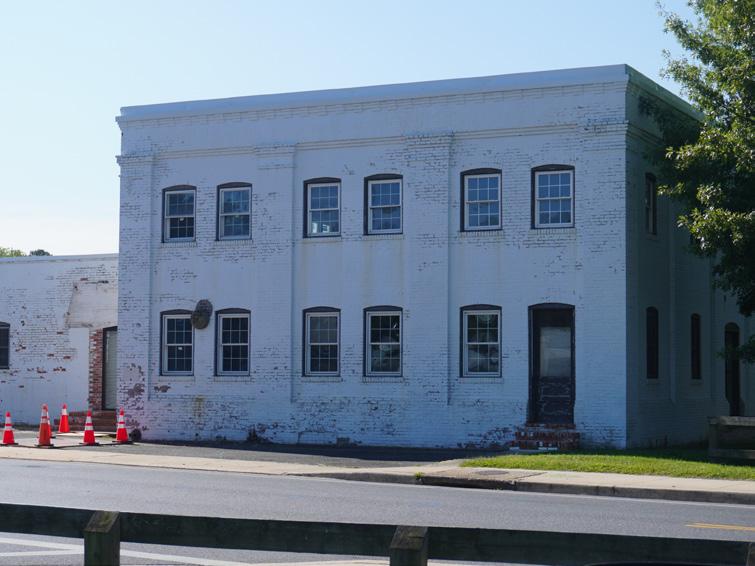
Figure 15. Example of typical historic commercial building along East Dover Street.
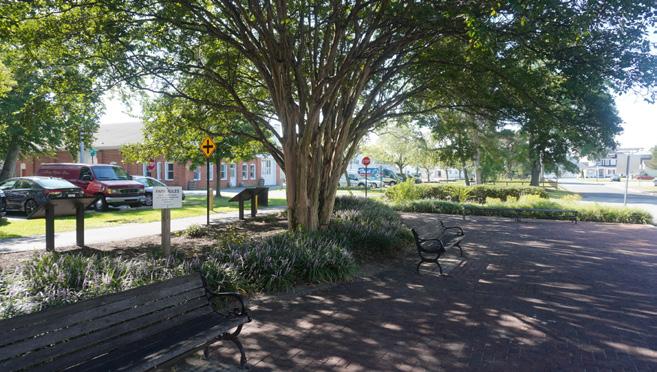
The deliberate and careful location of parks and open space areas that preserve the Town’s natural resources, as a complement to existing development, can be useful in guiding the Town’s development in an attractive, logical, and environmentally sensitive way. In addition to recreational and aesthetic benefits, open spaces can provide a framework for various land uses. Properly located, they become boundaries and buffers between conflicting uses of land, as well as a nucleus around which neighborhood areas can be designed and built, creating a Townwide system of “green infrastructure,” defined as a network of parks and open spaces, and the paths and corridors needed to link these areas.
General policy goals focus on continuing to meet the park and recreational demands of all of Easton’s citizens through a variety of different strategies, with an emphasis on acquiring more passive-open space. Policies specific to the East End Plan relate mostly to the extension of, and expanded utilization of the Rails-to-Trails corridor, including land-us-
es along the corridor which support and complement its use as a major recreational amenity and visitor attraction, as well as identifying opportunities within the Study Area for neighborhood-scale parks and opens space to help define neighborhood structure and identity.
Sensitive Areas
As a modest-sized town, Easton is unique, particularly among Eastern Shore jurisdictions, in that it has not until recently been located on a major body of water, when a recent annexation provided Easton some frontage on the upper reaches of the Tred Avon River.
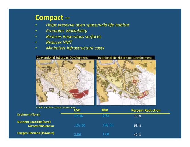
While the Town has many of the typical regulations regarding sensitive/ critical areas relating to streams and their buffers, floodplains, wildlife habitat, steep slopes, and forest conservation, etc., most of these rules will not apply specifically to the East End Study Area. However, there are many larger policy objectives which other principles outlined above can have a direct and meaningfully positive impact on. These include preserving habitat and reducing the amount of impervious surfaces, by prioritizing infill development, and by mixing uses and buildings more compactly, thereby reducing miles of travel lanes and redundant surface parking.
In addition, the 2010 Plan encourages the use of innovative stormwater management practices, along with municipal water and sewer systems, which can deal with development related issues in a more efficient, systemic way.
• To protect and, where possible, enhance the natural environment of the Town of Easton and its environs while recognizing the role of the Town as a regional growth center;
•Direct development, whenever possible, away from environmentally sensitive areas so that impacts are avoided to the greatest extent possible;
•Encourage the use of innovative and flexible development techniques as a means to protect environmentally sensitive areas;
•Ensure in large scale developments, that only the phase(s) currently under construction are cleared of ground cover so unnecessary runoff from these sites will be prevented;
• • Incorporate environmentally sensitive areas into the Town’s proposed system of green infrastructure;
To minimize and mitigate adverse impacts to water quality, encourage the use of innovative alternative stormwater management techniques;
•Continue to administer a Town Floodplain Ordinance to discourage construction within the 100-year floodplain; and
•Work with Talbot County to develop policies and regulations within the County that favor agricultural use and discourage development for lands in the Growth Area, unless said land is annexed into to the Town.
Water Resources
The relevant areas of the Easton 2010 Comprehensive Plan pertaining to East End Planning Area relate primarily to enhanced protections and efficiencies provided by municipal water and sewer systems utilized in compact, infill mixed-use development patterns, the reduction in nonpoint source nutrient loading related to smaller yards, and improved/ innovative stormwater management strategies.
Otherwise, the Plan states that the Town’s wastewater treatment facility
provides state-of-the-art treatment for all the Town’s residents and is to easily accommodate anticipated growth through 2025, with additional capacity beyond that.
Community Facilities and Services
For the purposes of this Assessment Report, the Portion of the 2010 Comprehensive plan relating to Community Facilities and Services, which are limited primarily to utilities and their Right-of-Ways within the Study Area, will be covered in another section of the report.
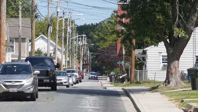
Transportation
Transportation issues are very important to Easton. The routes and terminuses that comprise the transportation system of Easton have a profound impact on Town residents, workers, and visitors. This system provides the means for these people to get from home to work as well as to shopping, entertainment, and cultural attractions both within and beyond Easton. Ensuring that this system operates efficiently, while respecting the numerous and sometimes conflicting needs of all who use
and are impacted by the system, is the general focus of this section.
Historically, most transportation concerns in Easton had something to do with US Route 50. In the 2010 Comprehension Plan, however, issues concerning the design of roads within subdivisions, and the degree of connectivity of those subdivisions to the rest of the road system of Easton has sparked a great deal of interest and brought hundreds of new people into the planning process. There was also a significant interest in alternate modes of travel (i.e. other than automobile). These additional questions reflect many of the more recent policy goals of the Comprehensive Plan.
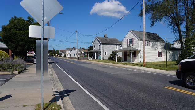
The opening of the Chesapeake Bay Bridge in 1952 allowed millions of Western Shore residents to easily travel to destinations on the Eastern Shore, primarily to Ocean City and nearby resorts. Since then, entrepreneurs have built a variety of commercial establishments, fast-food restaurants, and gasoline stations in particular, along the Route 50 corridor to entice a portion of this large migrating consumer market to stop in Easton.
While many business owners have benefited from the seasonal traffic
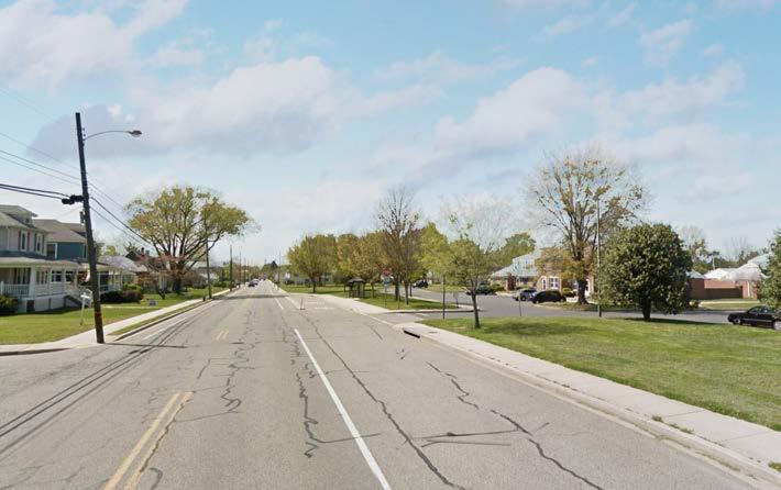
Figure 18. Example of suburban-style streetscape along Dover Road.
Figure 19. Highway-style commercial use in Study Area is not pedestrian friendly .
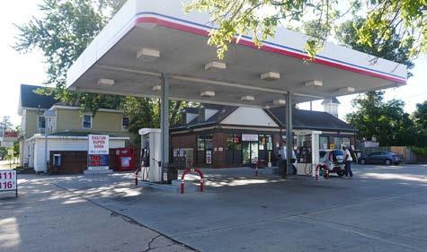
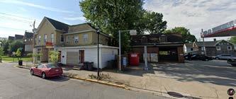
Figure 20. Triangle Gas, 321 East Dover Street.
along Route 50, this same traffic contains numerous negative impacts, ranging in scope from minor inconveniences to life-threatening dangers. The most basic source of these negative impacts is two-fold: (1) too many points of direct access onto/off-of Route 50 and (2) Route 50 trying to be two kinds of roads at once, a local service route and a quasi-interstate highway.
Beyond the brief mention of subdivision connectivity and alternative modes of transportation, the 2010 Comprehensive Plan primarily focused on the regional automobile transportation networks, and their impact on long distance commuter travel, with very little attention paid to local street networks, and how land-uses associated with those networks could help to address and/or ameliorate some of the negative impacts of those regional facilities.
As in many other sections, many of the larger policy goals outlined in the Plan speak more clearly to these concerns. Calling for more infill mixed-use development, and focusing more on locally-serving goods and services, will help to minimize both trip generation and vehicle miles traveled (VMT) with the Town, and along the Dover Street corridor, while also helping to keep those local trips off the regional transportation and commuter-related road networks, with the net effect of adding more capacity to those.
Economic Development
Providing jobs and the necessary means to enter and advance in the work force is the subject of the Economic Development Chapter of the 2010 Comprehensive Plan. It considers such things as the existing and desired job mix, the level and diversity of job training, appropriate level of government involvement in attracting major employers, and the future of the downtown as a provider of jobs.
Most of the economic data cited in the 2010 Comprehensive Plan referenced earlier studies, while focusing on long-term trends, including the growth in Tourism, and related spending. A large section devoted specifically to Easton’s Downtown, and relevant to the East End Planning Area, began by confirming its role as a tremendous community asset. Concern over its viability and its future are evident amongst not only the existing downtown business community, but also residents, visitors, and the Town Government.
Easton’s downtown is unique in several respects. Most notably is that it continues to function as a healthy and vibrant center for entertainment, commerce, and government, while many downtowns are either largely abandoned or are struggling to find an identity Easton's remains wonderfully preserved, physically.
Easton was selected a Main Street Community in the program’s initial year in Maryland. The selection recognizes the quality of Easton’s downtown, and serves as a tool to help ensure that it remains the special place that it is, emphasizing a tried and proven four-point approach to problem solving in terms of Organization, Design, Economic Restructuring, and Promotion.
Tourism remains a key focus as a critical and growing segment of Easton’s economic development. One reason is the multiplier effect or tourism spending, as a dollar generated by tourism has the potential to turn over many times in Easton. Tourism relates to the Downtown area in several ways. One, it is one of the destinations, undoubtedly the primary destination, for tourists who target Easton as a place to visit. Second and directly related to the first point, the Downtown is the location of many tourist-based uses like restaurants, lodging facilities, and cultural and entertainment uses.
Specific questions and concerns relate to the proportion of independent locally-owned business versus franchise businesses. Each helps to define Easton’s market niche in different ways, though studies show independent businesses tend to reinvest a significant higher percentage of the revenue locally than franchise businesses.
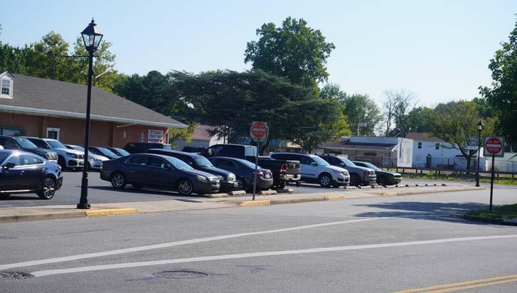
Another such issue is parking. Through the years, numerous studies have been conducted on this issue. They have generally and fairly consistently found that Downtown overall has a more than adequate supply of parking, but that it could potentially be utilized more efficiently by changes to the management of the spaces, including things like the mix and/or location of metered/free/permit parking, policies regarding maximum length of parking, etc.
Another aspect of Downtown is its role as a governmental center. Downtown serves as a central location for many Town, County, and State offices, as well as supporting professionals, providing a reliable day-time base of customers for many downtown businesses. The Downtown should remain a focal point for governmental activity.
Specific recommendations included:
• Enhance Marketing, Branding and Merchandising.
• Define Downtown’s Edge/Create a Green Ring Around Downtown
• Daylight Tanyard Branch.
• Reconnect the Northern and Southern Parts of Downtown.
• Focus on Filling-in Building Gaps and Activating the Street at Ground Level.
• Strengthen the Existing Retail Core.
• Create Contextual and Compatible Development.
• Encourage Downtown Residential Development.
• Create a Unified Parking Strategy and Parking District.
• Coordinate Open Spaces
The Economic Development Section relevant to the East End Planning Area included the following Goals and Objectives:
•Nurture a healthy and diverse local economy in Easton;
•Promote tourism by making Easton a vacation and leisure time destination;
•Encourage the diversification of Eastonʹs industrial base and work to reuse existing underutilized industrial and commercial buildings;
• •
• Work to retain and expand existing businesses and industries; Work with Eastern Shore Heritage Inc. to help promote Easton as a destination for heritage tourism as part of the Stories of the Chesapeake Heritage Area;
Revise Easton’s Zoning Map to ensure that there is an adequate supply of land zoned for the types of businesses we are seeking to attract and evaluate the standards of the Ordinance to ensure that the mapped zoning districts allow these uses;
•Provide the infrastructure necessary to attract desirable businesses and enable our existing businesses to grow and prosper;
•Maintain and, where necessary, recreate and support a vital Downtown;
•Protect the historic character of Easton and support projects and efforts which enhance that character;
•Support projects that implement the Downtown Plan for Infill Development;
•Publicize the availability of State and federal tax credits for Historic Preservation and the use of Maryland Smart Codes to rehabilitate historic structures;
•Encourage national franchises that meet an unfilled need to locate in Downtown Easton;
•Discourage national franchises that will directly compete with existing
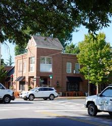
Figure 22. La Bodaga at the corner of East Dover Street and South Aurora Street.
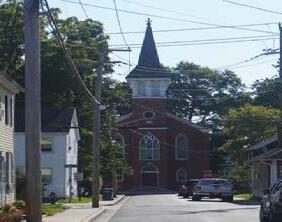
Figure 21. Historic Asbury Church in the Hill District.
locally owned and operated businesses from locating in Downtown Easton;
•Encourage infill development and commercial rehabilitation and redevelopment in the Downtown as the top priority for future commercial development;
•Strengthen the government services segment of the Downtown Easton economy;
•Locate all future Town of Easton governmental services (except Public Works Facilities) in the Downtown; and
• Encourage Talbot County to locate future County governmental offices in the Downtown.
Implementation
In implementing the 2010 Comprehensive Plan policies, a growth management strategy for Easton must first consider what the community feels is undesirable with the current situation. In doing so, it is important to recognize the many great aspects to the Town and identify and address any trends that are contrary to these aspects.
These may include:
• Development that is too wasteful of land area. Density in the older, historic parts of Easton is two to three times as dense as that found in the subdivisions of the last 30 to 40 years.
• Commercial development that is too ubiquitous or generic. In other words -- virtually indistinguishable from that in any other community.
• Growth that is spreading outward too quickly. There is concern amongst many residents that Easton is sprawling too far, too fast. And, since the density of the new growth in Easton is so low, more and more land is necessary to accommodate even a constant rate of growth.
• Construction of single-use subdivisions rather than mixed-use neighborhoods. Again, this causes a need for more land and necessitates increased automobile usage.
The 2010 Easton Comprehensive Plan offers specific recommendations to help manage Future Growth including:
1.Contain Sprawl with an Urban Growth Boundary (UGB)
The UGB is depicted on the Growth Area and Future Land Use Maps, and has been sized for the community to maintain its charm and quality of life. What this translates into in terms of future populations depends on the density of development within the UGB and the success of encouraging revitalization and infill redevelopment.
2.Increase Density
Bring new development to a level of density consistent with the Downtown area that so many people love and hope to see replicated.
3.Build Neighborhoods
This concept has been a recurring theme throughout the Comprehensive Plan, and was discussed extensively in the Community Character chapter and touched upon in several other places. The key is to incentiv-
ize this model of development while discouraging conventional suburban type development. In addition, policies should encourage long-term retrofit of existing subdivision to make them better connected, walkable, and with more convenient access to neighborhood goods and services.
4.Improve Design
Still, with all these changes, the Town will not generate a “sense of place” feeling unless improvements are made to the way the built environment looks. The challenge of the Comprehensive Plan is to ensure that this effort to improve design continues.
To accomplish this, the following recommendations are offered: •Consistently promote and require compliance with the “Design Principles for Easton” as described in the Community Character Element.
•Evaluate the effectiveness of the Design Guidelines for the various types of development (including residential) and revise if necessary.
Bicycle and Pedestrian Action Plan
As Easton continues to grow, it should embrace all methods of overcoming automobile dependency and simultaneously provide transportation options alongside continued economic growth and a healthy environment. Sidewalks and bike lanes, paths and trails make streets and town centers into destinations for shopping and entertainment. Similar to a “Complete Streets” approach, investing in walking and biking facilities helps local business and is an investment in the local economy
Easton has untapped potential to promote bicycle tourism. The unique character that defines this area and contributes to residents’ quality of life can also attract visitors that play an important role in the local economy. Priorities for bicyclists in selecting destinations include scenery, culture, bicycle-friendly roads or shared-use paths, services and accommodations with a bike-friendly orientation, and the uniqueness of an area.
Goals and Objectives for Bicycling:
• To promote and facilitate bicycling as a safe, convenient, and comfortable form of transportation and recreation in Easton.
• Make bicycling safe and inviting on the streets of Easton.
• Identify and sign select Bicycle Routes to improve way-finding among popular destinations in the Town of Easton.
• Increase the availability of bicycle parking and support facilities at destinations throughout Easton.
• Continue to develop off-road paths to create a connected trail system.
• Implement safety, education and encouragement programs to increase bicycle usage.
• Educate the public (motorists, bicyclists, and pedestrians) about bicycle and vehicle operation in traffic conditions.
• Encourage increased bicycling by promoting health, recreation, transportation, and tourist opportunities.
• Institute policies that support implementation of Bicycle Plan goals and objectives with community support and input.
• Improve enforcement of traffic laws related to bicycling.
• Institute new policies and procedures to support Bicycle Plan goals.
• Update street repair and maintenance practices to ensure bicyclists safety and comfort.
Goals and Objectives for Pedestrian Access:
• Improve the quality of the walking environment in the Town of Easton so that any trip can be taken on foot safely and comfortably, and where roadways equally serve pedestrians, bicyclists and motorists.
• Provide guidelines and standards for physical improvements that will make walking safer, easier, and more attractive to residents and visitors in the Town of Easton.
• Develop and maintain a pedestrian circulation system.
• Improve pedestrian safety and provide better service at street crossings.
• Support walking as an alternative to motor vehicles as beneficial exercise, an economical form of transportation, and as a benefit to the community.
• Promote walking as a means of improving health and active lifestyles.
• Develop programs and awareness initiatives that address pedestrian access, safety, rights and responsibilities.
• Create a safe pedestrian environment through effective law enforcement, detailed incident analysis and implementation of safety countermeasures. Improve enforcement of traffic laws related to pedestrian access.
• Create structure to implement the Pedestrian Access Plan goals and objectives.
• Institute new policies and procedures to support Pedestrian Access Plan goals and objectives.
• Update sidewalk and trail repair and maintenance practices to ensure pedestrians safety and comfort.
East End Neighborhood Revitalization Plan (1997) https://eastonmd.gov/517/Small-Area-Plans-and-Reports
The East End Housing and Neighborhood Revitalization Plan represented a watershed for comprehensive planning in the Town of Easton, in that it was the first to look comprehensively at a specific sub-area of the Town. As such, it was able to provide a more detailed analysis than municipalscale plans, with observations and recommendations appropriately tailored to the scale of the Study Area.
The Plan was produced with the active participation of neighborhood residents, through a series of meetings in which a small but dedicated group of individuals interested in the East End contributed to the final document, resulting in a collaborative effort between Town staff and local community members.
The East End in this plan consists of 115 acres located just west of Downtown, bounded by Goldsborough Street to the north, Park Street to the east, Brookletts Avenue to the south, and Hanson Street to the west, with a colorful history going back to the late 18th century, with Churches like Bethel African Episcopal Church dating back to 1818. Community Groups like the East End Neighborhood Association have long been advocates for improving the area with increased community policing, the development of local parks, and the provision of affordable housing.
At the time, the Plan did a Building Conditions Analysis showing the percentage of fit and structurally sound housing in the community at 65% and non-residential at 83% of the total for each, with the remainder either deteriorating, or dilapidated/vacant, with residential being the predominant land-use, and commercial properties concentrated along Dover Street. The Plan noted that the area had the potential, in terms of urban form and land-use mix, to evolve and revitalize based on the emerging development principles associated with concepts such as “New Urbanism” and “Neo-traditional Development.”
Demographically, the East End was characterized as 44% White, and 55% Black, compared to 72% White, and 27% Black, for the Town, overall.
A SWOT (Strengths, Weaknesses, Opportunities, and Threats) analysis was also undertaken. Perceived threats included deteriorating/vacant properties, a low percentage of home ownership, lack of quality housing, perception of crime/fear for personal safety, and internal traffic patterns. Perceived opportunities included the diversity of the people who lived there, including children, walkability, nearby amenities, neighborhood history and historic buildings, location, community activism/ East End Neighborhood Association, opportunity for new infill development, and Rails to Trails.
A detailed list of neighborhood wants and needs was also compiled, focusing on improving housing and increasing the percentage of ownership, neighborhood services, desired businesses, community parks and recreational amenities, including open space, and improved circulation/ streetscape enhancements.
Additional comments and suggestions focused on potential Land-use changes, including an expansion of the Town’s Central Business District two blocks south toward the study area for low-impact office and residential-commercial, given the general trend in that area. Another suggestion was to rezone tha area zoned industrial from when the rail was active, to residential, in addition to public restroom facilities relating to the linear park.
A final suggestion was for the area bounded by Brooklett’s to the south, South Street to north, and between Higgins Street and Rails to Trails, to be rezoned from industrial to commercial on the western
portion, and residential to the east. A number of smaller individual parcels were also recommended for possible park sites.
Additional Policy Goals and Objectives were identified in the Plan:
Land Use –
• Preserve and protect the stability of the neighborhood, and from encroachment from incompatible land uses and activities.
• Create more functional, smaller-scale park and open space areas throughout the neighborhood.
•Equitably provide community facilities and public services to all neighborhood residents.
•Maximize safety and efficiency of the existing East End neighborhood street network.
•Increase/enhance employment opportunities for neighborhood residents.
Housing –
• Preserve housing in good condition from replacement by other uses or public facilities unless a greater public need would be served by such action.
• Provide increased housing where possible for smaller households, including the elderly, semi-retired, and/or other families with no children.
• Encourage the maintenance and upkeep of existing housing, and facilitate the replacement housing that becomes unfit for human habitation.
• Provide a mix housing types and price-points to support housing opportunities for all neighborhood residents.
• Actively encourage and support the renovation or removal of substandard housing
• Vigorously enforce existing Housing and Building Codes to insure high standards of quality in new construction, with sensitivity to housing affordability.
The Easton Downtown Plan for Infill Development (2008) https://eastonmd.gov/517/Small-Area-Plans-and-Reports
Though not specific to the East End Planning Area, the Downtown Plan for Infill Development speaks to many issues and policies which may also apply to the East End neighborhood, while encouraging a degree of coherency within the Town’s historic core, given their immediate adjacency to one another.
Items from the Downtown Plan that have clear relevancy to the policy goals and objectives articulated in previous East End studies and reports, are outlined below in order as they appear within the Plan, with the applicable information summarized as needed.
General Concepts and Recommendations
After careful consideration of market trends and careful analysis, along with community input, The Downtown Plan for Infill Development laid out a set of general recommendations for the Downtown, which could also apply to the East End, and the Dover Road corridor specifically These are summarized as follows:
Focus on Branding and Merchandising
The Plan notes that downtown Easton is already widely recognized in its primary market as the historic center of Talbot County, but also as a hub for government, employment, and commercial services, as well as a cultural and arts center.
The key is to build on that recognition, while expanding the range and quality of retail goods and services at a variety of price points, but building a retail data base to help promote, manage, and support the mix of business and merchant categories in the downtown from a marketing and operational point of view.
Retail/Store Environment
The Plan recommends an ongoing program to build on the intrinsic visual appeal of the downtown, by updating the overall retail environment in general, with a more diverse range of dining and retail options, updated signage, window displays, etc., and creating a more attractive, familyfriendly pedestrian environment through the district. Also, improve the interior store environment with better merchandising, modern fixtures and updated lighting, furniture, and displays.
Tenant/Product Mix
Develop a tenant/product mix that will appeal to a variety of age groups, which are not currently represented Downtown, which reflect current retailing trends and fashions in clothing and accessories, home furnishings, health and wellness, etc., and a more diverse array of dining and entertainment options and cultural attractions.
Track Changes in Market Conditions
Identify unmet demand in the market (Gap analysis), and track growth trends in population and consumer demand, to remain competitive and maximize capture.
Define Downtown Edges/Access Corridors
The Plan recommends emphasizing the downtown’s compact and walkable character by clearly delineating its edges through signage, landscaping, and an enhanced pedestrian environment, a concept they referred to as “green streets.”
The Downtown Plan specifically mentions that major entry points into downtown, including the Dover Street corridor, should get similar attention, to provide a seamless transition from the arterial highway environment, all the way to the historic downtown core.
This strategy is consistent with the recommended improvements to the Dover Street corridor outlined in the previous studies and reports referenced in this document. By strengthening that perceptual connection, it increased the critical mass of both Dover Street and the Downtown as a unique regional destination in the County, and on the Eastern Shore.
Green Streets/pedestrian-oriented specifically Dover Street Corridor
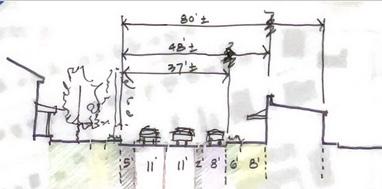
One of the key strategies outlined in the Downtown Infill Plan were a number of streetscape enhancements intended to create active and inviting street frontages, and to clearly define those areas associated with the Downtown Commercial District and its related points of entry. Specific recommendations include:
Streetscape enhancements.
Wider sidewalks, street trees/furniture, lighting, traffic calming, curbing/ crosswalks, etc.
Stormwater management.
Improved storm water management, including innovative/best practice facilities, such as rain gardens and bio-swales, minimize impervious cover by reducing surface parking, as well as the potential for districtwide facilities to help facilitate infill development.
Transport options.
Provide for a range of transportation options, including walking, clearly delineated bike lanes, shuttle and/or circulator buses.
Courtyards/plazas.
Create a variety of unique private outdoor spaces along the pedestrian way, including a courtyard, plazas, and pocket parks, to create an interesting and pleasant streetscape. Place all off-street parking either behind, or adjacent to buildings to maintain consistency of street frontage.
Focus on walkability/pedestrian safety.
Provide on-street parking, wherever possible, to help protect pedestrians and improve all crossings where needed.
Focus on historical street-fronting buildings, street-oriented retail, historic context.
Emphasize Easton’s uniqueness by working to save/maintain existing historical buildings and infill with compatible building types and styles, using traditional sidewalk facing storefronts.
Encourage more contextually compatible infill residential development. More infill housing downtown will help to activate the area and support local business.
Create a unified Parking Strategy and Downtown Parking District. It is recommended that the Town work with merchants to undertake an on-street parking initiative that surveys and maximizes utilization of on-street parking capacity based on demand pricing for short and longterm parking needs, and consider public-private partnerships in identifying and managing off-street parking sites, including the potential for municipal owned and operated garages strategically located to help anchor and support Downtown retail.
Open coordination/circulation.
Coordinate open space with downtown circulation and programming to attract and extend visitor stays to help support downtown retail and residential activity.
Infill Design Guidelines.
Develop design guidelines specifically for new infill development including building height, ground level and upper floor uses, and primary street frontage character consistent with existing building context in terms of “setback, orientation, scale, proportion, rhythm, massing, height, materials, colors, roof shape and configuration, building details, and landscape features ”
The Hill in Crises Report (2010) https://eastonmd.gov/517/Small-Area-Plans-and-Reports
Summary Introduction
The Hill in Crises Report examines the physical character of the East End African-American neighborhood in the Town of Easton, Maryland, known locally as “The Hill.” Its intent is to document the Hill’s unique qualities that sets it apart from the more affluent White neighborhoods in town that have been more thoroughly studied throughout Easton’s Historic District.
The focus of the report is based on the following observations:
1. That The Hill was historically a socially viable and cohesive community that contributed significantly to the economic life of the East End, since the early 19th century.
2. That the social and physical fabric of the community has broken down dramatically over the past 50 years (prior to 2010).
3. That its physical size and location relative to the downtown make it an ideal demonstration project for the Town, in that it could apply a package of incentives and economic stimuli to reverse decay and dereliction, thus improving the welfare of the inhabitants and the town as a whole.
4.That if successful, the town will have constructed a model program that could be applied to other neighborhoods and communities beyond Easton.
The report also acknowledged that if The Hill neighborhood were to be lost to neglect, or be insensitively revitalized in a way that erases its
character identity, the town will have lost much more than simply decayed buildings, but a significant record of the town’s own heritage.
Historic Significance
The Hill neighborhood in the report consists of a four-block area, bound on the north by South Lane, the south by Talbot Street, the east by Higgins Street, and the west by Aurora Street. The report examines the physical architectural characteristics of the community, which are described as a simpler, modest vernacular style of architecture with minimal trim, expressed in terms of the rhythm and pattern of its structures along the block frontage.
Scale and Massing - Lot Size
A sense of diminished scale compared to other historic sections of Easton, close to the sidewalk, with a greater percentage of lot coverage relative to open yards and streets. Second floor ceiling heights are often 7’ or less, with shallower roof pitches, and siding that further emphasizes the small size of the homes.
Pattern and Rhythm
Houses in The Hill neighborhood typically take one of two forms: The first type are referred to as “Railroad Houses,” which present their gable fronts to the street in a repetitive line, creating a regular and repetitive saw tooth street profile. Porches reinforce this pattern as a repeating pattern of triangles with either hip or shed roofs with either two or three column bays. Differences in detailing are minor, with the rhythm and pattern of the roof line dominating the street elevation.
The second type are referred to as “Match Box Houses,” standing eave to eave, presenting a solid wall punctuated with consistent precision, by two windows up and one down plus a door, and a simple gable roof with the ridge running parallel to the street. The entry door typically has a covered stoop, with either a small shed roof cantilevered at the stoop, or a small gable porch roof, supported by simple, narrow posts, some supporting flanking side benches. As with the Railroad houses, the dominant visual characteristic of the type is the repetitive pattern of the collective street elevation.
Notable Details
Within the context of the repetitive pattern, windows are typically oneover-one sash, with or without divided lites, constructed of wood, metal, or vinyl. Doors are equally modest, with both doors and windows, and simple trim, compositionally subservient to the uniform box shapes and their repetitive pattern, best viewed at a slight distance.
The Report recommends a modest set of clear instructions regarding any exterior construction to strengthen the neighborhood’s historic fabric. This can lead to the creation of a viable, safe, sustainable community for working class families that reflects the Town’s historic heritage and contributes to the economic well-being of the larger community.
The Hill Small Area Plan (2011)
This Plan, undertaken by Morgan State University School of Architecture and Planning, initially submitted in Draft form, and never formally adopted by the Town of Easton, nonetheless represented a reasonably complete and comprehensive overview of The Hill neighborhood’s history and built condition, including a detailed survey of existing historic structures and inventory of buildings over 50 years in age (in 2011), with a resurvey of the community showing over 80 percent of the structures as meeting “contributing” status.
The Draft Plan provided an inventory of sidewalks and “green cover” (street trees) and existing businesses by type, with retail, food service/ hospitality, and professional services making up over 60 percent of those uses, mostly clustered near the intersection with Washington Street, and a smaller cluster near the rails-to-trails linear park. The Draft Plan also provided a schematic master plan showing proposed improvements, including an Arts District, and identified “opportunity areas,” potential parking nodes, designated green spaces, as well as illustrative proposals for specific urban design interventions.
A subsequent abbreviated presentation was produced in 2014, outlining key elements of the plan, summarized below.
SWOT Analysis:
Strengths –
• Significant historic resources
• Town’s good quality of life
• Walkability
• Commitment to sustainability
• Diversity Weaknesses –
• Vacant/dilapidated housing and high percentage of rentals
• Lack of job opportunities
• Poor quality of some streets
• Lack of connectivity Opportunities –
• Rise in heritage tourism
• Growing Health Care industry in the area
• Easton’s strategic location
• Center of activities in Talbot County Threats –
• Lack of business attraction
• Big Box Retail competition/shift to US Route 50
• Influx of low-skilled workers
Vision Statement:
The Hill community is the historic jewel of the Eastern Shore. By integrating its significant past with a promising future, The Hill serves as a model for how historic preservation, sustainability, cultural diversity,
stable housing mix, and economic growth can function and serve as a foundation for a vibrant 21st century community.
Core Values:
• Accessibility and Inclusion
• Historic Preservation
• Appropriate Character and Image
• Sustainable Design
• Cultural Diversity and Community Participation
• Respect for Privacy
Goals and Objectives:
•Improve the network of open spaces, recreational areas, transportation systems and community facilities.
•Protect natural resources and be environmentally responsible
•Achieve an integrated housing balance that includes a diversity of housing types.
•Revitalize the housing stock to prevent blight
•Protect, preserve, restore, and maintain historical and cultural resources
•Promote an understanding of the value and significance of The Hill
•Maintain a Sense of Place by enhancing the small town charm of The Hill, relative to the Town of Easton.
•Stimulate the neighborhood and local downtown economies
•Prepare a workforce to support an emerging economy.
•Promote public safety practices that protect residents, businesses, visitors and tourists from threats and harm
•Achieve full and meaningful participation of residents in planning and decision-making activities.
•Increase collaboration between the Town of Easton, preservationists, and a diverse array of non-traditional partners.
East End Final Group Paper
The East End Final Group Paper was prepared as part of Salisbury University's Applied Planning Class student project and as a prelude to updating an earlier East End Neighborhood Revitalization Plan that was completed in 1997, and included an online survey and public meeting, information collected from both, and several recommended actions and proposed next steps to address the issues and concerns identified through that process.
Online Survey
An online survey was prepared to gather preliminary information regarding the residents’ concerns, values, and ideas in advance of the public meeting. The survey asked several questions relating to the future of the community in terms of what they would like to see there, and how best to protect the neighborhood’s unique qualities and character.
There were multiple general responses that were repeated through the survey, which were narrowed down to three main topics for discussion for the public meeting.
The first theme was recreation, expressing a need for more green space and recreational opportunities in the neighborhood, and improvements to existing parks and recreational areas. The second theme was business, with respondents mentioning the need for more small and diverse businesses to fill the empty retail spaces. And the last theme focused on restoration – the need to restore buildings on the 300 block of Dover Street, and improved maintenance of rental homes and overall housing renovation, to help maintain the neighborhood’s historic character. Secondary topics included crime and public safety
Public Meeting
A public meeting was then held at the Brooklets Senior Center, in Easton, with an information station for each major theme, manned by teams of students to interact with and record resident’s comments, along with a round table map exercise related to perceptions of crime and safety. The results were made available before the meeting to provide some background information and talking points.
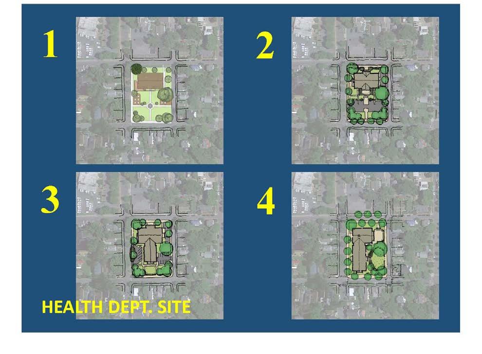
Recreation
The information collected at the Recreation table focused on several specific concerns, with the most common being the general lack of open space for outdoor recreation and/or indoor recreation space. A second main category of information gathered focused on the old health department property, and its potential to be converted for use as a park, or other recreational use, given its location in the heart of the community. A representative from Asbury Church also attended the meeting and discussed the Church’s plan to open a nonprofit community recreation/entertainment center that is family-focused and includes an arcade.
Business
At the Business table, the primary objective was on gathering input on how business could be improved in the general area. Desirable uses mentioned included a creamery, a farm to market restaurant using locally sourced goods, some organic shops, and a general convenience store, since the closest grocery store was on the other side of the highway.
Locations of opportunity identified for new/additional businesses included the 300 and 400 blocks of Dover Street given the traffic volume and visibility. Another location mentioned was along the Rails-to-Trails, where visitors take advantage of many outdoor activities, and access to nearby parks as a main attraction in the East End. Specifically, they thought a place serving cold refreshments would fill a real need, possibly along with some food trucks.
Restoration
The restoration table focused on things the residents would like to see cleaned up or worked on. One of the main concerns discussed was the restoration and preservation of the Buffalo Soldier House and how it could be restored without losing its historical value. Another building that was mentioned was the Health Department building, which was felt
to be dilapidated and should be torn down and property redeveloped as a park and green space.
Buildings along the 300 block of Dover Street were also mentioned as examples of where owners were not maintaining or restoring them.
Specific goals and objectives mentioned included:
Recreation
•Creating, where possible, new open space for recreation in the neighborhood.
•Supporting efforts of local community groups to establish recreational facilities.
•Improving the safety of existing recreational facilities.
•Redevelop the old Health Department property into an open space as park and playground
•Support Asbury Church in establishing a community recreation/ entertainment center.
•Use signage and other techniques to improve safety where the Railsto-Trails intersects roads.
Business
•Renovate buildings on the south side of the 300 and 400 blocks of Dover Street.
•Bring small businesses to the area that support health/welfare.
•Exploit opportunities along the rail trail.
•Attract businesses that support families and youth recreation.
•Explore adding bathroom facilities and food trucks along rail trail.
•Explore business/grocery opportunity at the old paint store.
•Restoration.
•Improve communication between the Town and its Hispanic residents.
•Encourage landlord responsibility for building upkeep.
•Preserve the historic value of the Buffalo Soldier house, and the neighborhood in general.
•Consider buying out dilapidated properties.
•Convert the Health Department building into a park and greenspace.
Market Analysis for Easton and Talbot County, July 2024
Overview
Running concurrently with the East End Small Area Plan and Community engagement process, the Easton Economic Development Corporation retained the services of the Chesapeake Group, Inc. (TCG) to undertake a Market Analysis of Easton and Talbot County to measure the potential market demand for both residential and commercial development in the area.
Using long-term market trends, and forecasted new demand based on a range of demographic and income data and available market products, the Analysis showed latent demand for a range of product types and
affordability not currently offered in the market. This analysis looked only at the demand side, and not what was currently being offered, and though the Study looked at both the Town of Easton and Talbot County as a whole, it appeared to suggest a significant opportunity for the East End in terms of meeting that unmet demand.
Specific Data looked at during the Analysis included:
•Historical permit patterns.
•Sales trends.
•Likelihood of moving.
•Internally generated new households.
•Income levels and affordability of new units
•The desire for smaller housing units.
•Age composition of households.
•The desire for walkability.
•Historic market share.
•Competitive positioning.
•Continue success with visitations from those living beyond Talbot County.
Residential Analysis
In general, the Study looked at historical permitting data from two periods, the first being from 2000 though 2010, and the second being from 2011 through 2022-3. The first period showed an average of about 420 units of housing being built per year, one-hundred percent of which was single-family detached housing on individual lots, with the peak absorption taking place between 2005-2007, just prior to the financial crisis
The pace of building the fell off significantly in the years immediately following the financial crisis.
The next period, from 2011 through 2022, with a few minor exceptions, followed a similar trajectory of building primarily single-family attached houses on individual lots, for a total of 1,455 units, or about 132 units per year on average, only 4.5 percent of which were in multi-unit buildings. During that period, the number of units built, as well as the price per square foot, fluctuated significantly year-to-year. But only twice during the entire period did the total annual supply in any given year exceed even half the average annual rate of construction in the previous 10-year period.
Both unit and overall average gross pricing was only given for the second period, from 2011 through 2023, with the square foot unit price ranging from a low of $170.83 per sq. ft. in 2015, to a high of $326.89 per sq. ft. in 2023. The overall average lowest price per unit during that period was $403,285, again in 2015, while the highest was $757,988, in 2023, with the average size per unit remaining relatively constant at around 2,300-2,400 square feet.
Of course, within those County-wide averages, actual costs varied signifi-
cantly based on zip code and location, with waterfront and historic properties commanding a significant premium ($4.2 million for waterfront, and $950,000 in Easton), while the average price of homes within the County without waterfront or historical characteristics was $686,000, with only two zip codes having average sale prices of $426,000, or less.
In General, the Analysis showed that this pricing is significant when compared to income levels. Realtors Property Resource is a wholly owned subsidiary of the National Association REALTORS. Its data indicates that the median household income for Talbot County and Easton ranged from $75.2 thousand to $91.4 thousand.
The survey of residents conducted as part of this analysis indicated the following:
• The mean average income is about $161,000.
• The mean is generally higher than the median by between $20 thousand or 20 percent.
• About one-third of the households have incomes below $100 thousand, and 55 percent are under $150,000.
• Talbot County is likely more significant because of the substantial number of households with incomes above $250,000.
• Given the housing prices, for a unit with a monthly payment of $3,568, the average annual payment would be $42,816 annually.
• 47 percent to 50 percent of current Talbot County residents cannot afford to buy a home on a small lot in Easton at present unless transferring equity.
• The percentage that cannot afford to buy a home on a small lot is higher for Easton residents.
The larger implication being that most new homes were being produced at a cost greatly exceeding the affordability rate of the median household income in the market, based on standard industry metrics. Again, this was looking primarily at the demand side, relative to what was actually being produced in the market.
While looking specifically at the market for Easton, and by extension, the Dover Corridor/East End, the Study identified three general market generators for new housing in Talbot County and jurisdictions like Easton. These are -- internal movements of current residents to different homes; the internal generation of new households that results from the independence of youth raised by current residents or changes in household structure through divorce or other factors; and external movement or relocation of households from beyond the county.
The report went into significant detail in looking at these three market generators, starting with those looking to move within the County (internal migration), which holds particular relevance to the East End Study Area. Within this group, the primary reasons given for moving are the need for more affordable housing, aging, the cost of living, the health of
household members, property maintenance, and retirement.
The potential needs of these existing households indicate several niche housing opportunities.
• There is a substantial housing niche for those fifty-five or older.
• This market opportunity could likely be accommodating dispersing new units in neighborhoods, corridors, or concentrations of larger clusters.
• Most new units built to accommodate the existing population would be two bedrooms or less.
• Studio flats also represent about a ten percent share of this market opportunity.
• There is likely latent demand at present and demand in the future for housing for those with incomes $50,000 or less.
• About one-half of all households likely to move have annual incomes of at least $100,000.
•More than four out of every ten who may or are be likely to move will seek homes smaller than their current homes.
•The desire for smaller and even same-sized units is concentrated in households with primary income earners fifty-five years or older.
•Almost one-quarter of those who will seek smaller homes live in units less than 2,000 square feet.
New Housing Unit Estimates
Based on the above factors and considerations, demand for additional housing from the development and redevelopment of parcels in and around Talbot County, Easton, and the Dover Road corridor were estimated as follows:
•
• • Over the next ten years, between 3,100 and 4,300 new attached housing units can be absorbed in Talbot County Within Easton, between 1,700 and 2,300 units can be absorbed, potentially between 250 and 500 units in the Dover Street corridor. Ten-Year New Housing Unit Absorption for Talbot County: Low/High Estimate 3,100/4,300, and for Easton (largest municipality) 1,700 2,300.
To summarize the residential market potential for the East End -- more than four out of every ten who may or are likely to move will seek homes smaller than their current homes, and the ability of Talbot County and Easton to accommodate these households will depend on the future housing stock and its market suitability relative to the anticipated demand.
Commercial Analysis (Overall)
The commercial part of the TCG analysis/report focused on both retail goods and services, as generally defined by merchandise category, based primarily on the projected growth in the number of household units within the market area, and commercial (office) space also needed to meet the growing demand for services and local employment those additional
households will also generate (assuming 200 sq. ft. per new household). Entertainment, was also considered as a separate business category with anticipated growth, fueled by continued growth in the visitor market as well as the local resident population.
Retail Demand for Talbot County, excluding Easton
According to the report, most income and assets are spent on three essential commodities -- housing, food, and transportation. Demand for retail goods and related service space is supported by spending from local residents and those from beyond the immediate consumer market, or Primary Trade Area for Talbot County, excluding Easton
Direct spending on retail goods and related services is defined through the resident household expenditure, based on the projected increase in the number of households, across the following merchandise categories, and tallied based on current and project sales through 2034, with both a low and high estimate in sales volume by dollar. The resulting growth in net supportable square feet should maintain any existing businesses, assuming competitiveness, while creating demand for new retail spaces and filling existing spaces.
Talbot County market-generated sales are expected to grow by 2034 between $121 million and $173 million from $776 million in 2024, or approximately 16 and 22 percent, respectively. This excludes sales generated by residents of Easton.
This translates into a corresponding increase in supportable space of between about 373 thousand square feet and 532 thousand square feet by 2034 from a total of 2.4 million square feet. These broadly defined merchandise categories are further broken down in the report, to include a number of related subgroups, each with their own respective growth projects Most of those subgroups follow similar proportional growth projections.
In addition to the residentially generated market outlined above, employees and others who pass through the area to go to and from
work and visit friends, families, and attractions add to the market. TCH conservatively estimated those visitations add $20 million in potential consumer spending, and an additional 120,000 sq. ft. feel in retail goods and services space, again, excluding Easton.
Easton and Dover Corridor-Specific Market Analysis
Looking at the potential growth in consumer market potential exclusively within Easton, and assuming that market potential will be driven primarily by growth in the number of households in Easton itself, the market analytics indicate that between 1,700 and 2,300 units can be absorbed in the next ten years, with potentially between 250 and 500 units of that absorption taking place in the Dover Street corridor and surroundings.
Specifically:
• About 920 new housing units have been approved in Easton.
• Of those 920 units, 811 were yet to be permitted, meaning only about 12% of those units have been completed.
• A total of 383 of the 920 units were attached or “multi-family” units, with 284 of the units yet to be permitted, meaning only about 25% of the attached or “multi-family” units approved, have been completed.
• However, of the 12% approved new housing units completed, 90 percent were attached or “multi-family.”
In looking at the market for new residential units in Easton, the TCG report estimated that a maximum 1,928 attached units can be built on available land within Easton. However, the estimated actual unit yield would be 1,455. As noted, the units would generally be two to three bedrooms, with about ten percent being one bedroom and/or studio units, for Talbot County
However, for Easton, the percentage of one-bedroom units could be higher, at between twenty and twenty-five percent. Additionally, an active adult community of 1,500 and 2,500 would be marketable in Talbot County and could be located in Easton or on its border if the land is available, adding to the total number of new housing units that could help support new retail growth in the local consumer market.
Retail Demand for Easton and the Dover Corridor
Similar to the new household growth-driven over the next ten year increase in net consumer spending potential (maintaining existing businesses) for Talbot County (excluding Easton), the TCG calculated the increase in consumer spending potential for that period (low add/high add) as follows.
As defined, the number of households and rooftops will expand in Easton over the next ten years. Growth based supportable square feet are new spaces for which demand will exist and can be used to build a new inventory of space or fill vacant spaces. Easton market-generated sales are expected to grow by 2034 between $138 million and $187 million from $540 million in 2024, or approximately between 26 and 37 percent, respectively. Or, almost twice as much as that for the County as a whole.
Space inventory corresponding supportable space will grow by between 426 thousand square feet and 576 thousand square feet by 2034 from a total of 1.7 million square feet, or approximately between 25 and 34 percent.
Available Space Inventory
As part of TCG’s market analysis, a survey of Easton’s existing buildings was made including space along the following streets and areas:
• Downtown
• West Dover Street
• East Dover Street
• West Street
• Federal Street
• North Harrison Street
• North Washington Street
• Goldsborough Street
While not all of the areas surveyed were within the East End Study area, they are presumed to be indicative of the general attributes of existing retail space in the downtown Easton/East End Study Area. The survey findings are shown as a graph in the TCG report, but the key takeaways are as follows:
• The average building has 7,300 square feet of building at ground level and above.
• • The largest percentage of available spaces, about forty-four percent of the buildings, range in area between 4,000 and 7,500 square feet. About seventeen percent of the buildings have at least 10,000 square feet.
In addition, the following statistics were documented:
• The total space is about 642,000 square feet.
• Roughly 414,000 square feet are active retail space.
• About 116,000 square feet are occupied office space (to be addressed separately).
• Roughly 82,000 square feet are vacant, with 63,000 square feet focused on Washington Street.
• About 186,000 square feet of space are associated with food and beverage services, amounting to about 46 percent overall.
With the following observations and conclusions:
• Residents of Easton alone currently support about 174,000 square feet of food and beverage space in any and all locations, including those outside of Easton.
• The supportable square footage of such space roughly equals locally generated demand for food and beverage operations.
• Easton residents will support an additional 45,000 to 60,000 square feet of food and beverage space in the future.
• Easton resident demand growth will support between 426,000 and 577,000 square feet of space at any and all locations.
• The Easton resident demand is more than sufficient to fill vacant spaces and support additional commercial space.
• Other Talbot County residential growth will support growth in commercial space between 372,000 and 572,000. Even a small capture (rate) of such space in Easton further strengthens the potential for new space.
• No growth in consumer spending by visitors is anticipated. However, if visitation numbers continue to grow, expansion of commercial space opportunities may be feasible.
(Author’s note: The TCG’s overall report summary includes specific retail-related findings and recommendations, which are noted below, however it seems clear that there will be significant opportunities for new retail-related and mixed-use related infill/redevelopment and adaptive re-use, in both the overall East End Study area, and the Dover Street Corridor, specifically.)
Office Space Associated with Non-Retail Goods and Related Services At the time of the TCG’s Market Analysis for Easton and Talbot County, the office market in Easton, like office markets everywhere, was still evolving and being influenced by the larger regional and national trends post-Covid. However, some of the trends more specific to sub-markets like Easton (historical, main-street communities) were noted as follows:
• Continued popularity of hybrid work.
• Tenants’ desires for shorter-term leases.
• Too many dated buildings that once stored paper files and hosted server rooms.
• Too few single-tenant buildings that meet changing needs.
• Declines in the amount of square footage needed per worker.
• Increases in virtual meetings.
• Increases in medical patient virtual meetings.
• Digital replacement of book libraries in law offices and other professional offices.
• Difficulties with landlords getting returns if they put a lot of capital into a reconfiguration and are unable to get terms and a rental rate that reflects the costs of those improvements.
Despite these challenges, the TCG report notes that the significant increase in households anticipated for Easton will generate new demand for office space in the community to fill the growing demand for services and local employment, based on an assumed additional 200 sq. ft. of space, per household related employment.
This growth in demand indicates that between 68,000 square feet and 92,000 square feet of space will be marketable in the next ten years. The increase in demand can be used to fill vacant spaces or for new structures. This increase in demand will be sufficient to fill some of the existing vacant spaces and potentially create a small amount of new office space in the foreseeable future.
Entertainment
The last component of Commercial-related market analysis in the TCG report is entertainment. According to the TCG’s analysis, residents of Easton currently spend about $44 million on entertainment annually. This figure is projected to increase to about $50 million annually in ten years, with anticipated capture of fifty percent of this total.
County residents, excluding Easton’s, are expected to spend an additional $52 million in 2024, with twenty percent or $10 million additional capturable in Easton. In addition, visitors will spend an added $16 million on food service activity in Talbot County, with forty to fifty percent capturable in Easton, bringing the total to about $40 million. These capturable dollars will support about 30 thousand square feet of retail goods and services space.
Though seasonal visitor patterns remain challenging, the CG report assumes that visitor activity can contribute an additional 15 thousand square feet to the retail goods and related services industry. Maintaining an average 70 percent occupancy for room accommodations indicates that the hospitality inventory of rooms should not grow beyond existing and proposed unless a substantial increase in visitor activity is noted. Increased use of the trail system could add to the viability of food services but is not likely to significantly expand off-season occupancy rates.
Easton Opportunities Synopsis
The TCG Easton and Talbot County Market Analysis report identified numerous focus areas for Easton to increase market segment penetration, by creating internal synergy, and enhancing or creating specific niches and clusters for new market opportunities, and/or creating specific
niches and clusters for new mixed-use opportunities.
TCG Defined opportunities are as follows.
a) Between 1,700 and 2,300 new housing units. The units could provide redevelopment, infill, or small pocket developments on single or assembled sites.
b) Between 340 and 500 units would be one bedroom, creating opportunities for start-up households, senior households, and second homes. These units could be detached units or “flats” ranging in scale from 800 to 1,100 square feet or attached units.
c) Other units would be primarily two-bedrooms with between 1,000 and 1,300 square feet of space. If attached units and “non-flats”, at least one bedroom should be on the first floor.
d) Demand will support between 426 thousand square feet and 576 thousand square feet of added retail goods and related services space.
e) At least 100,000 square feet of added space should focus on food services, with several operations providing evening entertainment venues appropriate for various age groups.
f)Targeted corridors and downtown properties are appropriate locations for food service operations, through retrofitting or new space creation. Not all food service operations will involve the costly construction of complete kitchens.
g)Clustering of food service operations is an appropriate and desired option for new development, infill, or reuse.
h)The feasibility of expanding the Amish full-year indoor farmers’ market should be explored, creating a seven-days a week, year-round commercial anchor.
i)Between 68,000 square feet and 92,000 square feet of office space will be marketable in the next ten years and used to fill vacant space or for new structure occupancy. Outpatient health care and orthopedics are likely focuses with the continued aging of the population.
While TCG’s Easton and Talbot County Market Analysis report does not specifically identify what proportion of each of the defined opportunities described above might be specifically applicable to the East End/Dover Road corridor Study Area, it seems clear, based on the report as a whole, that a number of the defined opportunities would be particularly relevant to the East End, particularly the smaller, and multi-family residential unit types, and innovative models of small-scale infill mixed-use development in meeting the anticipated demand for both retail and commercial office, including maker space, as described and documented in the East End Small Area Plan Charrette.
Easton Strategy Development
In concluding its Easton and Talbot County market analysis, TCG outlined a set of strategies for implementing the policy objectives implicit in their findings, describing them as a set of activities to facilitate positive changes in the community, particularly with regard to job creation and workforce housing affordability based on the perceived likelihood of
success.
Specific recommendations included:
• Local support for an increase in housing to accommodate the above can come from the following --
1. Modifications to real estate tax policies, including delays in payments at the onset of projects.
2. Sale or lease of government owned land.
3. Waiver or delay of utility hookups and other related fees
4. Additional opportunities exist through the development of smaller housing units. As noted, there is a strong demand for homes below what is typically found in the area.
5. 600 to 950 square foot one-bedroom homes oriented toward young households and seniors/ these could include small/micro lots, attached flats, or duplex units.
6. Employment of emerging construction techniques, including 3D printing, off-site, and robotic construction.
Other areas of TCG focus included:
•Home maintenance -- Continued support for seniors remaining aging in place by assisting with home maintenance provided through a nonprofit repair service or an affordable “guarantee” fixed-price system for standard repairs.
•Expanding the “off-season” Visitor Market by focusing on food yearround -- Rising average temperatures make expansion of “close-by” events and activity feasible. Marketing Talbot County, Easton, Saint Michaels, and others should expand during the winters.
•Promotion > food service -- Easton food services marketing should be the key to expanding the visitor season. The focus should be on increased off-season food events with promotion geared toward nonTalbot County residents, including expanded off-season restaurant weeks and weekends. Promoting National shipping of “Easton” food specialties should also be considered.
•A community kitchen to strengthen entrepreneurship -- Community kitchens are spaces owned by an organization or business that are open and available to local food entrepreneurs, caterers, and others. Community kitchens for shared use have many advantages, and could be a key driver of future economic activity in the Study Area.
• It could help foster entrepreneurship.
•The facilities could strengthen operations typically found in farmers’ markets.
•They could attract younger households interested in culinary arts to Easton.
•The kitchens could provide an ongoing supply of restaurateurs.
Management options follow:
• The business or organization would hire professional management/ leasing and cleaning companies. Better terms would likely be achieved through the hiring of small or independent companies.
• Proper legal tenant/user responsibilities must be developed to meet all safety and health code requirements.
• Linkages with educational programs for chefs and restaurant management could be established with community colleges and other academic institutions.
• The community kitchen dramatically decreases the start-up costs for food service businesses, baking for supermarkets and others, those who participate in farmers’ markets, online sales, etc.
Potential leases can be for one month or less, but more likely for three to six months, up to one year, and triple-net and CAM charges would be included. Grants would likely be available from the Federal government, including USDA and the State of Maryland to cover potentially significant portions of the development/renovation costs.
Netflix entertainment center as part of an expanded restaurant venue –
•With the expansion of food service activity, TCG suggested Easton may want to consider branding itself as a Location Based Entertainment (LBE). LBE experience is a consumer-oriented category that combines elements of hospitality, leisure, and retail, in a thematic setting. Location based entertainment venues are destinations that consumers visit with the expectation of being entertained.
Large-scale LBE locations typically include multiple entertainment, lodging, dining and shopping choices appealing to various age groups. Smaller LBE venues may offer one or two core experiences such as a themed restaurant or live performances paired with self-service entertainment.
Ripken Sports Complex with an extended season --
• Ripken sports complexes are expanding throughout the country, with their home base still in Aberdeen, Maryland. Though not appropriate for downtown, TCG suggests that a complex oriented to bring youth for tournaments ten months of the year should be sought.
Demographic Data
The East End area is the most diverse area of the Town of Easton, economically and ethnically. The Plan’s boundaries include over 2,000 people and 838 households. The median household income is $50,914 with a fairly balanced mix of high school graduates (26%), those with some college (26%), and those with a bachelor degree or higher (36%). The unemployment rate is a low 2%. The African-American population comprises 12.4% of the total East End population and nearly 28% of the population identifies as Hispanic.
In 2023, Easton, Maryland, had a population of 17.2k people with a median age of 45.6 and a median household income of $73,460. The racial makeup of the town is predominantly White (Non-Hispanic) at 67.5%, followed by Black or African American (Non-Hispanic) at 14.4%. Here’s a more detailed breakdown of the demographics:
Population and Growth:
• The population of Easton grew from 17,118 to 17,202 between 2022 and 2023, a 0.491% increase.
• The median age is 45.6 years.
• The median household income is $73,460.
Racial and Ethnic Composition:
• White (Non-Hispanic): 67.5%
• Black or African American (Non-Hispanic): 14.4%
• Two+ (Hispanic): 4.9%
• Other (Hispanic): 4.74%
• Two+ (Non-Hispanic): 3.02%
• Hispanic: 9.1% of the population
• Poverty Rate: 12.95%
Source: Data USA
A survey was conducted by The Chesapeake Group (TCG) as part of their market assessment. The survey of area residents was conducted online, and yielded results for over 500 “unique” households. The focus of the survey was on current and future spending capacity, based on income. It is noted that all surveys, including the US Census Bureau, have inherent biases.
TCG noted that online surveys typically tend to decrease input from lower-income households that often have lesser experience or availability with the Internet. It is biased against seniors, but that is not true for Talbot County. The average age of the primary income earner in the survey is 58. Most households, irrespective of the age of the primary income earner have annual incomes between $50,000 and $150,000.
Given the price of housing sold, the income is below that necessary to purchase homes unless other assets or resources are applied, including dollars from the sale of an existing home. Furthermore, younger primary-income earner households generally have lower average incomes. The gap between younger household incomes and affordable ownership units will impact on Talbot County and Easton, including continued aging of the population and growing services needs for the older age groups, school enrollment issues, and labor force issues.
Table 13 - Age and Income Clusters Identified through the Resident Survey*
*Developed by The Chesapeake Group, Inc., 2024.
Approved and Proposed Private Sector Development Plans
Prior to the beginning of the Charrette, the Consultant Team was made aware of several development proposals within the Study Area, that are either under construction, received Planning Commission approval, and/or have initiated an engagement process with the community.
These private sector development plans include:
•The Dover Station and Brewery (under construction),
•The approved site plan for The Shoregate at Cannery Multi-family Community (96 units);
•The conceptual Hill Community Museum;
• The seven-unit Laura Mansion middle housing infill project;
•The Easton Crossing Community, Listening Session II and Initial Design Presentation, September 18, 2024; and
•The approved site plan for the Silo Square Townhouse Community (28 units).
Residential Development Pipeline
Prior to the beginning of the Charrette, the Consultant Team was provided with the Town’s residential development pipeline, current through February 2024.
Figure 24. Residential Pipeline by Town of Easton.
Existing Utility Infrastructure
Prior to the beginning of the Charrette, the Consultant Team received several technical documents and resources from the Town Engineer and the Easton Utility Commission. The Team also met with representatives of both entities in order to review current and future utility construction in the Study Area.
In addition to information found in the Town Code regarding utility construction, the Consultant Team received several important documents regarding:
• Existing water, sewer, gas, electric and communication facilities,
• Stormwater design requirements,
• Street design requirements, and
• A gap analysis of current pedestrian facilities.
Figure 25. Approved street sections for new streets, from the Town of Easton Design Manual.
Figure 26. Detailed existing conditions summary of select streets within the Study Area. Produced by the Town of Easton staff.
4.Study Area Context
Study Area
Relationship to and within the Larger Comprehensive Plan
The East End Small Area Plan Charrette Study Area, comprises approximately 335 acres, roughly bounded by Goldsborough Road to the north (extended up to Cherry Street), Aurora Street to the west, Stewart to the south, and US Route 50 to the east. This process is intended to support and inform the larger Comprehensive Plan update process as it pertains to the East End, and the Comprehensive Plan’s overall mission, which is to provide:
• A unified statement of desirable development policies.
• A framework within which specific development issues can be evaluated and public policy effectuated consistent with the longrange growth and development goals and objectives of the Town.
• An information document for local elected officials, citizens, developers and special interest groups concerning critical development issues as well as Town development policies.
Within this context, and as a public participatory process within a historical, longer-term, policy-oriented set of planning initiatives, this East End Small Area Plan Charrette is intended to confirm and update those larger policy goals and objectives previously identified and applied through this process in the form of a site-specific framework and detailed master plan.
Specific alignment with the larger Comprehensive Policy Goals include:
• An acceptance of the need for new housing, coupled with the need to adequately address the negative (real or perceived) impacts of such growth, such as traffic congestion, school capacity, environmental impacts, etc.
• A desire for a greater variety of shopping options, without significant new areas of regional-scale retail.
• A preference for the majority of new growth to be of an infill/ redevelopment nature despite there being relatively few opportunities for such development, at least under current zoning rules and regulations.
• The desire to facilitate all of the above while still maintaining a uniqueness and small-Town authenticity in the Easton of the future.
Study Area Relationship to Surrounding Area
The Study Area resides primarily adjacent to, and East and South of Easton’s historic core, but with critical connections to other parts of the City, and other regional destinations. There are two main corridors in the East End; the east-west Dover Street and the north-south Rails to Trails. The nearly 3-mile Rails to Trails, built along the former railroad right-of-way, opened in 1998. The trail is used by recreationists, pet walkers, and commuters and provides excellent access to adjacent residential neighborhoods, the Dover Street corridor, parks, and medical clinics.
Figure 27: Study Area Plan. Plan illustrates the Study Area boundary, as proposed by the Town of Easton. This Study Area was slightly adjusted by the Consultant Team during the Charrette.
In addition, the park-like area between the Plan area’s two major eastwest streets, Dover and Goldsborough, provides a great opportunity for enhanced civic space. This area includes a restored historic railroad station which serves as office space for the Town’s Code Enforcement and Parks and Recreation departments. There are several parcels adjacent to the Rails to Trails corridor with potential for redevelopment into additional housing units and limited commercial uses.
The Dover Street corridor remains the commercial heart of the Plan, with the east end of the corridor starting at the intersection with Route 50 and continuing west into the heart of downtown Easton and its county courthouse. The East End commercial corridor consists of three sections:
The first section is the three-block historical retail corridor that begins at the intersection of Dover and Aurora Streets (and some adjacent properties) and ending at the crossing of the Rails to Trails. This section of the retail corridor reflects the diversity of the surrounding neighborhood and includes a mix of traditional retail storefronts and a strip retail center interspersed with stand-alone residential and institutional land uses, with minimal upper-story residential.
The retail in this section of Dover Street is predominantly neighborhood goods and services, mostly serving the local East End community Downtown Easton’s commercial offerings, on the other hand, are primarily food and beverage oriented, targeting the larger regional consumer market. However, the East End has begun attracting a number of unique, independent food and beverage concepts, which combined with the interest in growing the Arts and Entertainment focus of the East End, could really help to make the East End a destination in its own right, while growing Easton’s overall market penetration on the Eastern Shore.
The intersection of Dover and Aurora Streets is anchored by three restaurants somewhat emblematic of the slowly gentrifying aspect of the Plan area; Rude Burger, La Bodega, and Rude BBQ. The retail corridor is not a continuous corridor of retail storefronts; it is interrupted with a town-owned surface parking lot, senior apartment complex, funeral home, and a gas station. Institutional businesses include the immigrantfocused Chesapeake Multicultural Resource Center, Maryland Midshore Intergroup, the Democrat Party Headquarters, and the Sala Evangelica Asamblea Cristiana church.
The second section begins at the crossing of the Rails to Trails which then transitions to a mix of commercial uses interrupted with singlefamily residential homes. This middle section of the corridor is anchored to the east with Rise Up Coffee -- a complex on both sides of the street that includes a take-away coffee shop, seasonal tent, and drive-through kiosk on one side of Dover and a roasting facility on the other side
There is limited retail in this section of the corridor, near the intersection of Dover Road, Dover Street, and the Rails-to-Trail. These are primarily located within a small strip center, along with renovated Dover Station, which includes a curated product marketplace, small bistro, and meeting space. Additional plans will include a craft brewery and food and beverage business.
The third and final section of the corridor is the gateway into the heart of Easton from Route 50 and consists of primarily residential and institutional uses. The south side of this section of the corridor is mostly lined with single-family homes or duplexes and a pizzeria. The north side includes a multi-family residential community owned and managed by the Talbot County Housing Authority. Next to that is The Chesapeake Center complex, a residential and service-based center for adults with disabilities, along with an Auto Zone Walgreens and Wawa gas station both front Route 50.
And finally, the Plan area includes a portion of The Hill, founded in 1788, and one of the oldest free African-American neighborhoods in the United States still in existence today. Concerned by condemnation and demolition of the town’s historic African-American sites, residents undertook extensive research on the history and significance of The Hill community, incorporating historiography, oral history, land records, genealogy, archaeology, and preservation to document its story.
With distinct housing types including railroad houses, matchbox houses, and duplexes, The Hill area also includes the historic Asbury Methodist Episcopal Church, a Gothic Revival structure that dates to 1876 and was dedicated by Frederick Douglass in 1878.
Locations for commercial development within the Study Area can give some merchandizing/tenanting suggestions for co-tenancies/clustering:
• East Dover Street from Aurora to the Triangle
• The Triangle itself, anchoring the center of the R2T
• The “Arts and Industry” corridor along the R2T south of Dover
• The “Arts Village” cluster at R2T and Brookletts
• The intersection of US Route 50 and Dover Road Districts
and Incentive Zones
The Study Area is a large, complex, and multi-faceted sector of the Town of Easton. It includes a variety of governmental rules and incentives in the form of districts and zones. One of the primary controls, Chapter 28 of the Town Code, is the zoning code.
Zoning Districts
The Town’s zoning map graphically depicts the rules and regulations associated with the Town’s various Euclidean zoning districts, sub-districts, and overlay districts.
There are twelve (12) Euclidean zoning districts in the town. These dis-
tricts include the A-1, Agricultural District, three residential districts (R7A, R-10A, and R-10M), four commercial districts (CB, CG, CL, and BC), a single industrial district, a single governmental/institutional district, a regional healthcare district, and a mixed-use waterfront district. Some of these districts have sub-districts. The Study Area includes seven of these twelve base zone districts.
In addition to base Euclidean zones, Chapter 28 includes several overlay and floating zones:
• Planned Redevelopment Overlay District (PROD),
• Historic District,
• Critical Area Overlay District (CAOD), and the
• Planned Unit Development District (PUD)
With the exception of the CAOD, the other overlay and floating zones are within the Study Area.
Historic District (Section 28-601)
The purpose of the Historic District is to establish regulations and procedures necessary to preserve sites, structures and areas of historical, archeological, or architectural significance. The various historic districts are considered overlay districts where its regulations are considered in conjunction with the underlying zoning district. The western portion of the Study Area includes historic district overlay zones.
The portion of the Study Area with the Historic District overlay includes some of the historically significant structures. However, some sites may be candidates for removal, while others may be candidates for inclusion in the overlay. The Charrette process reviewed the importance of the Historic District overlay zone and its influence on the planning of this area. Notable, the historic train station on the R2T and Asbury Church also have Maryland Historic Trust easements.
Planned Redevelopment Overlay District (PROD
The PROD is an incentive zone whereby the Town promotes innovative redevelopment of specific portions of the Study Area.
Figure 28. Sustainable Communities
Rails-To-Trails Corridor
The Study Area is bisected by the Rails-to-Trails corridor which runs generally north and south. This corridor follows the former rail system and provides an important organizing element for future development. There is a planned extension of the trail that would run through the former rail system, running generally west and east, and located slightly north of Idlewild Avenue.
Focus Area within the Study Area
In addition to the overall Study Area, the Town identified a specific, and smaller Focus Area within the Study Area, which received more detailed planning attention, including alternative plan concepts for community review and comment during the Charrette process. As discussed later in this report, the Consultant Team identified Focus Area nodes that included special study and detailed planning analysis.
Figure 30: Existing zoning map with the Study Area boundary overlaid (Source: Eyes over Easton GIS)
Figure 29: Study Area, Focus Area and various overlay districts. (Source: Town of Easton). Includes Historic District (Orange), Planned Redevelopment Overlay Zone (Purple), Hill District (White Hatch). Darker orange areas are where the HD and PROD overlap. Study Area is in red, the Town identified Focus Area is in yellow.
31. This image was produced circa 1908. It visually identifies the character of the Town and the Study Area at that time, showing several industrial sites and planned roads moving east from what is now the Historic District. Several key buildings and sites are identified including the Health Department parcel, Asbury Church, the Train Station, and the Dover Triangle.
Figure
5.Pre-Charrette Outreach & Engagement
Prior to the Charrette, the Town of Easton provided several community engagement opportunities. Early in the process, the Town of Easton established an Easton East End Project web site. This on-line presence became a primary portal for outreach and updates on the project. It includes draft work product from the Charrette, on-line survey information and periodic updates on progress.
The Town also notified stakeholders, neighbors, civic associations, and homeowner associations through postal and electronic mailings.
There was a kick-off meeting for the Easton East End Small Area Plan on October 5, 2023 at the Waterfowl Building. It was attended by approximately 90 persons. At this event, James Rojas of Place It! led an inspirational and fun workshop where participants envisioned and assembled their vision of great communities art-making as its medium.
The Town also conducted interviews with key stakeholders and offered an on-line survey and interactive map where residents could offer opinions and comments about existing conditions in the Study Area as well as aspirations about future outcomes of the planning process.
Prior to the on-site Charrette, the Town and a local bike advocacy group sponsored a Community Walk Around on October 12, 2024. Several key sites within the Study Area were visited and thoughts and comments were offered by attendees. A summary of the event and the comments received is in this report at Appendix A-2.
From October 12 to 23, 2024 the Consultant Team continued to gather base information and conduct informal meetings with stakeholders.
The more formal community engagement Charrette was held October 25 to 28, 2024 at the Church of God, located at 1009 North Washington Street. It included presentations, community engagement pin-ups, stakeholder meetings, open studio reviews of draft work product and nightly in-progress presentations to attendees. This process is detailed in the next section of this report.
On-Line Resources:
Town of Easton: https://eastonmd.gov/
Eye Over Easton: https://experience.arcgis.com/experience/6e4fcffdb826413c8398b8b9913545d2/
East End Small Area Plan: https://eastonmd.gov/602/Engage-East-End-Building-Our-Tomorrow
Town of Easton Code: https://eastonmd.gov/220/Code
2008 Easton Downtown Plan for Infill Development: https://eastonmd.gov/DocumentCenter/View/1303/Easton-Downtown-Plan-for-Infill-Development-2008
1997 East End Neighborhood Revitalization Plan: https://eastonmd.gov/517/Small-Area-Plans-and-Reports
2010 The Hill In Crisis Report: https://eastonmd.gov/DocumentCenter/View/668/The-Hill-In-Crisis-Report-2010-
Figures 32-35:. Various images from pre-Charrette citizen outreach “walk around” of the Study Area, focused on the key sites of the Study Area held on October 12, 2024.
6.The Charrette
Process
The interactive, public-participatory planning and design process for the East End Study Area is called a charrette -- a French-term describing an intensive, short-term design project originally associated with the Ecole des Beaux-Arts, in Paris, but later adopted in the US and elsewhere, to mean any kind of planning or design process that involves an intensive, relatively short-duration, comprehensive planning and design process, that includes a formal community input and iterative feedback component. The East End Small Area Plan Charrette, meets that definition.
The Charrette took place at the Easton Church of God, located at 1009 North Washington Street, in Easton, and ran from October 24th through October 28th, 2024.
The Charrette schedule included an opening night presentation and community design workshop, where residents were encouraged, with the help of facilitators, to document their thoughts, concerns, and aspirations of individual base maps, which the Charrette Team referred to throughout the process to help guide their work.
This initial input informed the first day’s work, at the end of which a formal pin-up was held, where the team’s proposals were presented to the community to consider and comment on, relative to that initial input. This process was repeated each day of the Charrette, including an “open-house” event, allowing for continued refinement of the initial design proposals, as the plan expanded in scope and detail throughout the process -- culminating in a final plan which covered every aspect of the community’s input, in sufficient detail, and with accompanying graphic exhibits, to ensure a credible outcome with broad community support.
Feedback
Though community turn-out for the interim pin-ups was numerically less than anticipated, the level of engagement and the quality of feedback was high, offering detailed and insightful input into the process overall, particularly as the Focus Areas plans became more specific in terms of detail and content.
Consistent themes emerged early on, which echoed and reinforced many of the themes outlined in earlier studies and reports. These included maintaining the historic character of the Town in general, and the East End in particular, including the Hill; improving connectivity and pedestrian safety; preserving the unique industrial character of the area along the rails-to-trails corridor while supporting and promoting an industry and arts culture, specifically including small incubator spaces for budding artists; and enhancing the commercial vitality of the Dover Road corridor, along with a range of detail improvements throughout the Study area.
Figure 36. Charrette Schedule.
October 24, 2024
Opening
Figure 37. Various images from the opening night presentation, located here and on the following page.
39. Early planning studies from Day One regarding the area near the Brookletts Building.
On Day One, the Consultant Team began by reviewing the existing conditions within the Study Area and developing suggested alternative infill and development scenarios for some of the key sites, including the Rails-to-Trails corridor.
Day One Pin-Up and Presentation
Figure 40. Field notes during Study Area existing conditions analysis. In addition to input from the community, the Consultant Team conducted multiple site visits to the Study Area and surrounding neighborhoods to better understand the context for the study. The Study Area was documented by photographs, some of which are included in this report at Appendix A-1. Field surveys were conducted by car, bike and on foot on multiple days and times prior to the Charrette and during the Charrette.
Figure
Figure 38. Initial rendering of the ‘Artixan Village’ near the Brookletts Building.
Figure 43. Early planning study from Day One, analyzing the potential transportation options at the Dover Triangle.
Figure 41: Planning study delineating improvements and enhancements along the Dover Road/Street corridor from Aurora Street to the west, and US Route 50 to the east.
Figure 42. Proposed street section for Dover Road, introducing on-street parking and liner buildings at the existing bus stop.
The Framework Plan
The Framework Plan provides a graphic representation of all the elements contained within the East End Study Area that were part of the Charrette process, in a single geographic reference. These include the major vehicular corridors that either traverse or bracket the Study Area, in both the E-W and N-S directions, the Rails-toTrails linear park system, and the Key nodes within those networks which represent the Focus Areas, as well as any other relevant feature and/or amenities which we specifically referenced during the Charrette.
Day Two’s efforts focused on the finalization of the Framework Plan, the refinement of the various Focus Area options, and development of specific strategies for pedestrian safety and traffic calming.
October 26, 2024
Framework Plan
Idlewild Park
Figure 44: Study Area Framework Plan and detail. .
The Rails-to-Trails Corridor
The Rails-to-Trails linear park system was identified early in the design process as a key corridor that links many of the identified Focus Areas and connects the East End with the greater community. It is identified as the green corridor in the Framework Plan.
This illustration is a graphic depiction of the key elements of the corridor and includes some suggested enhancements such as landscaping and pedestrian connections.
Northern Gateway
The trail enters the Study Area as it crosses the North Fork of Tanyard Branch. As the trail proceeds southerly, the contextual character changes from rural, to urban, and eventually the trail crosses Dover Road. The Consultant Team saw this ‘northern gateway’ to the community as an opportunity for context-sensitive landscaping, and the relocation of stormwater facilitates, if necessary, from the Dover Triangle area.
Train Station
The train station is a key community resource. Early design ideas include better pedestrian connectivity, use of the building for retail or community groups, and improvements to the outdoor sitting area. Small scale infill development on the east was suggested as well.
Dover Triangle
Brooklets Building
The Brookletts Building was identified by many stakeholders as a community resource to be reused. The Consultant Team incorporated the building into early designs that focused on the opportunity for infill development at the site and on adjacent parcels. The Team later refers to this area of focus as Brookletts Crossing.
Infill Buildings
South Lane/ Asbury Church
The Hill District is of great importance to this area. The Consultant Team’s suggestions built on earlier work by the Frederick Douglass family and the University of Maryland student project.
Early design ideas include Asbury Church as a centerpiece of culture, greater connectivity in the area, and improvements to South Lane.
The intersection of the rails-to-trails, Dover Street, and Dover Road was identified by the community and the design team as a critically important community resource that was under-utilized and lacked cohesion. Early design ideas included the creation of a true community place with enhanced sidewalks, pedestrian space, and new infill development. Also, the team saw redevelopment at Dover Station as a catalyst for this area that could be built upon.
There is a mix of light industrial uses and residential in the southern portion of the Study Area. Early design suggestions include greater pedestrian connectivity to the trail, the introduction of small mixeduse buildings, and enhanced landscaping.
Early design ideas included enhancements as a light industrial enclave, pedestrian improvements, and small-scale infill development as a transition to residential homes.
Regional trail connections and an enhanced connection to Idlewild Park are suggested.
Figure 45. Early Day One planning study showing the importance and unifying nature of the Rails-to-Trails corridor.
The Health Dept. Property
Though technically located just outside the East End Study Area, the Charrette participants strongly felt that the Health Department site represented an unfilled opportunity to provide a Community Center and public open space amenity in an under-served part of the Town, which was also conveniently accessible to East End residents.
There were five alternative plans prepared for this site. The fifth option (not shown) is a park option. These four plans provide alternative designs that allow for a variety of uses on the property. Some options maintain and re-purpose the existing building. One option provides an expansion of the existing structure and another assumes a replacement with a new building. Existing parking is reduced in all options, including some that rely on public, off-site parking.
The proposed redesign shown in Option 3 removes most of the off-street parking to create a neighborhood park, and small outdoor event space. The building itself has a new building entrance on the east side, more directly accessible to South and Thoroughgood Lane frontages, and the adjoining residential block, as well the East End neighborhood. Proposed uses could include a neighborhood health clinic, meeting space with catering kitchen and flex space/classrooms to meet a variety of community needs.
Figure 46. Four alternative development plans for the Health Department site.
The
Hill District
Figure 47. Illustrative representation of proposed Hill District improvements from student report/study, source: The Hill Small Area Plan, Morgan State University School of Architecture and Planning (draft), 2011.
Figure 48. Two alternative “after” views and conceptual diagrams showing proposed street improvements in Hill District.
Figure 49. Charrette illustration showing potential infill locations in the Hill District.
Transition to the Historic District
Historic District to Dover Triangle Transition: Easton’s Historic District overlaps western portions of the East End Study Area, including portions of East Dover Street, making this section of the Dover Road corridor a critical transition zone as the physical character and the nature of the land-uses changes heading east, toward Rt. 50.
The primary focus here would be to manage infill development in a way the enhances the existing historic fabric of this area, which has already begun, while ensuring that when redevelopment does happen, it happens in a way that is wholly compatible with the historic character and scale of Downtown Easton. As an illustrative example that could become a legitimate project, the Charrette Team proposed the redevelopment of an existing Town-owned surface parking lot into a mixed-use community center/café and black-box performance venue that could help to support artists living and working in the area.
Proceeding just east of the Historic District is Dover Triangle, with the recently renovated building at Dover Station. As another illustrative example for a proposed redevelopment along the corridor, the Charrette Team proposed an enlarged and reimagined triangular park at the intersection of Pennsylvania Avenue and Dover Road, and the phased redevelopment of the single-use, suburbanstyle shopping center at 419 Dover Street into a street front mixed-use commercial complex, fronting directly on the new park.
By eliminating the short section of Pennsylvania Avenue from Dover Street, to Dover Road, and incorporating the remaining Rails-to-Trails median in the existing triangular green, the redesigned park will become significantly larger than the current park, while also greatly simplifying traffic movements at that location, and improving pedestrian safety throughout the entire Dover Triangle.
Urban Design Strategy
• Excellent urban fabric should be replicated in eastern blocks
Infill Opportunity
Redevelopment Strategy
Infill Opportunity
• Town Owned Property
• Civic Space Opportunity
• Urban Design Improvements
• New Civic Space
• Pedestrian Safety Improvements
• Traffic Calming/On-Street Parking
• Streetscape Improvements
• Infill Redevelopment
The proposed incremental redevelopment of the shopping center is designed to allow existing tenants to remain in their current location while the new mixed-use buildings along the street front are constructed, and then each tenant can be relocated into the new space, while their portion of the old building is demolished and incorporated into a new surface parking lot to be located to the rear of the new buildings.
It is anticipated that this approach could add significant new leaseable space to the existing center, while also making room for some community spaces, if needed, upper floor professional services, and/or rental housing units above the ground-floor shops.
Urban Design Strategy
• Long-term strategy for infill development
• Safety and parking improvements
• Streetscape improvements
Pedestrian Crossings
• Safety Improvements
• Intersection Modifications
Intersection Geometry
• Intersection Modifications
• On-Street Parking
• Traffic Calming
Urban Design Strategy
• Intersection Modifications
• Long-term Development Strategy for Station
• Facade Improvements
• Streetscape Improvements
Figure 51. East Dover Street.
Infill Opportunity
Just west of Dover Triangle and north of the Hill District, on East Dover Street, the Charrette Team looked at redeveloping an existing Townowned surface parking lot, in the combination community center/café and “black-box” theater, as a community-focused resource for local artists. This use would function as a social gathering and networking place, that would also create greater economic value and return on the Town’s investment in the property, by helping to support local artists, community non-profits, and independent businesses, in a revenueproducing location.
Figure 52: Early architectural facade studies.
Figure 53: Site aerial.
Figure 55: Conceptual floor Plans.
Figure 54: Black Box Theater.
Day Three
Day Three of the Charrette included refinements to previous plans, consolidations on design concepts where alternatives where still being analyzed, and the creation of additional graphics and illustrations that assisted in conveying design concepts. The day culminated in the final pin-up of the charrette.
October 27, 2024
Framework Plan
Idlewild
Train Station Enhancements and Incremental Infill Development
Dover Triangle Civic Space and Surrounding Infill Development
Figure 57. Detailed Plan of Dover Triangle, Dover Road East, and the Rails-to-Trails corridor.
The Dover Triangle
Dover Triangle Focus Area:
The Dover Triangle Focus Area represents one of the most important locations within the East End Study Area, as it resides at the intersection of the Dover Road commercial corridor and the Rails-toTrails regional path system, making it one of the most densely traversed pedestrian crossings on what is potentially the East End’s most active and important commercial street. It is also unique in that this location also coincides with a change in alignment from Dover Road, to Dover Street, creating the triangle shape which also provides a unique opportunity from an urban design point of view.
The proposed redevelopment of the large commercial parcel located adjacent to this intersection, assumes the incremental (phased) replacement of the outdated existing suburban-style shopping center, into a street front mixed-use commercial block. This parcel lies directly across from the enlarged and programmatically enhanced triangular park, making it ideal for hosting community events.
The larger park was created by simplifying and reducing the existing street layout by terminating Pennsylvania Avenue at Dover Street, prior to reaching Dover Road. This greatly reduces potential vehicular/pedestrian conflicts, while minimizing congestion by eliminating confusing vehicular turning movements, thereby making the Rails-to-Trails pedestrian crossing considerably safer and more pleasant at the same time.
By moving the shopping center parking to the rear of the site, and bringing the storefronts up to the rear of the sidewalk, directly across from the improved park, this redesign would create a clearly defined urban place along the Dover Road corridor, where none currently exists, and provide an important and critical anchor along the transition of “bringing Downtown further east,” into the center of the East End, and with the other proposed pedestrian improvements along Dover Road east, closer to Route 50.
East Avenue - Existing Conditons
East Avenue - Re-imagined
Figure 60.
Figure 61.
Figure 58:
Figure 59:
Figure 63. Aerial view showing proposed Dover Triangle improvements, including a redeveloped suburban shopping center as mixed-use center with street front shops and cafes, and parking relocated to the rear, a remodeled liquor store with new façade, a greatly enhanced and expanded triangular green with fountain, new on-street parking, and significant pedestrian safety improvements..
Figure 62: Overall Framework plan for reference.
1
7 5 6 2 4 3
Dover Triangle Phasing
The existing suburban-style shopping center located in the 400 block of East Dover Street, though very well leased, is an older structure, set back from the street behind a somewhat awkward and inefficient surface parking lot, in a style incompatible with other historic buildings nearby.
The Charrette Team proposed an incremental redevelopment plan (shown here), which would allow for the phased construction of new mixed-use buildings along an improved East Dover Street pedestrian frontage, coordinated with the similarly phased demolition of portions of the existing building, once those tenants have been relocated to the new building, and that portion of the property redeveloped as an efficient and easier to use surface parking lot.
In addition to increasing the amount of leaseable area in the existing center, the illustrated proposal assumes that the enlarged and greatly enhanced triangular green, improved traffic circulation and pedestrian safety features, including new onstreet parking, will encourage other owners proximate to the green, to make similar improvements to their facades, and/or redevelop their own parcels in a similar fashion.
Figure 64. Illustrative phased implementation/build-out strategy for proposed Dover Triangle commercial center improvements.
Figure 65. Proposed Dover Triangle .
Brookletts Crossing
Figure 66: Overall Framework Plan.
Figure 67: Brookletts Crossing Detailed Plan.
Brookletts Crossing/Kemp Lane: The Charrette proposal for Brookletts Crossing combines several ideas into one Focus Area, centered around the existing Brookletts building and the Rails-to-Trails corridor and linear park, which includes Kemp Lane. As part of the larger Arts and Entertainment policy initiatives, the illustrative proposal takes advantage of the currently vacant lot across the trail from the Brooklets building, and the “maker-space” small-unit light-industrial building just east of that lot, to a proposed mixed-income “Artist’s Village between the two, and also terminating Kemp Lane Charrette proposed changes to the zoning code allowing small-scale incremental infill maker-space along that street frontage creates a scattered-site cluster of Arts and Industry-related housing and work space.
With the increase in nearby residents and the daytime worker population, the before and after views along Brooklets Avenue shows a proposed café at the ground level of the Brooklets building, facing the avenue, and new on-street parking and marked pedestrian crossing (ideally with a stop sign in both directions) to help slow through traffic, and to encourage more pedestrian traffic between those uses in the area.
Brookletts Crossing - Re-imagined
Figure 69.
Figure 68.
Figure 70.
Kemp Lane/Dover Road East
As a response to ongoing Policy initiatives to encourage new, small-scale infill development on existing parcels (see Prior Studies Section of this Report), specifically to support smaller entrepreneurial enterprises in the East End, the Charrette Team proposed two locations where such redevelopment activity could occur.
Kemp
Lane - Existing Conditions
The first would be along Kemp Lane, and could support a mix of different uses in a work-live configuration, including light industrial/fabrication, small-scale commercial, even retail/entertainment, in the newly designated Arts and Industry district (see before and after illustration).
The second would be toward the east end of Dover Road, on the north side, as it approaches Rt. 50. In this location, most of the existing structures are pulled back from the street, with surface parking lots between the building and the rear of the sidewalk, creating a very poor pedestrian environment and a suburban context inappropriate for Easton. By reconfiguring the street section to allow for on-street parking and wider sidewalks, and adding shallow “liner” buildings to hide the surface parking lots behind, the pedestrian environment is transformed, while providing affordable retail space along an ideal commercial frontage.
Figure 71.
Figure 72.
Figure 73. Key Map showing Brookletts Crossing focus area and the Kemp Lane infill area.
Dover Road East
Traffic Calming:
A traveler on Dover Road from Rt. 50 to downtown Easton, through the East End, experiences a gradation of land-uses, urban form, and road type, from very suburban and pedestrian unfriendly, to very urban and walkable, in less than half-a-mile. Each step along that transition presents a very different pedestrian environment, and therefore, a different traffic calming strategy and approach, from active and deliberate coming in off Route 50, to inherently subtle and intrinsic, in the historic core of the Town.
This image graphically represents that transition: Red indicates less frequent (given the higher speed during the initial transition) but more overtly obvious pedestrian crossings – clearly marked and signalized crossings, combined with on-street parking, where possible and reduced travel lane widths, combined with deliberate modifications to the pedestrian environment.
Orange indicates a slower design speed as we transition into a more pedestrian intensive zone, more frequent intersections, and active street front commercial. Traffic here could include additional marked crosswalks, with at least one pedestrian-activated signal at the event venue, and again, on-street parking, some of which may include reconfiguring some existing off-street spaces.
Green indicates transitioning to a true urban pedestrian environment, with on-street parking, wider sidewalks, narrower travel lanes and smaller turn radii, and possibly a traffic control device (i.e., signal) and marked pedestrian crossing at every other intersection.
Figure 73: Diagrammatic illustration showing relative levels of proposed traffic calming/pedestrian improvements from Downtown Easton to Rt-50, and from most walkable, to least.
Dover Road East:
The transition from Dover Triangle east toward Route 50, is a stretch of roadway collectively referred to in the Framework Plan as “Dover Road East,” which provides a number of different challenges to address from a land-use, urban form, and pedestrian safety perspective.
Toward the west end of the stretch, a cluster of innovative food and beverage concepts, including Rise-Up Coffee Roasters, with its outdoor seating area and shipping containers, anchor this part of Dover Road, with the residential fabric on the south side providing a degree of pre-war coherency. However, the street section itself is very suburban, which encourages higher speeds, in addition to the heavy traffic volume that a major east-west arterial traversing the Town typically generates.
Further east, toward Route 50, the north side of the roadway offers a range of suburban-type commercial landuses, set far back from the street with large surface parking lots along the frontage, all of which contribute to a very unfriendly pedestrian environment. Unfortunately, a recent infill residential project on this side street repeated the past mistake of also pulling back from the street, exacerbating the problem.
To address this issue, the Charrette Team proposed traffic calming initiatives that were both site-specific and corridorwide. The site-specific initiative included pedestrian activated crossing signals at the pedestrian activity node between Rise-Up Coffee Roasters the south side of Dover Road, and their out-door performance venue across the street on the north side.
For the corridor as whole, the Team proposed the introduction of on-street parking wherever it could be accommodated within the right-of-way, along with a road diet (i.e., reducing travel lane widths, where feasible), to help slow the speed of traffic, without reducing volume.
To create a more small town urban feel, and a more interest-ing pedestrian environment, the Team proposed shallow-depth commercial “liner buildings” along the north side frontages where both the residential and commercial uses were set-back from the road in a more typically suburban type format, to help shield the pedestrians from the surface parking lots otherwise lining those frontages.
Combined with wider sidewalks and street trees, and activated storefronts, these improvements should help slow traffic, encourage pedestrian activity, and provide the kind of small commercial spaces which will encourage and support the smaller, more unique independent business enterprises
that help make the East End feel special and different from the highway commercial a short distance to the east, and provide a much more appropriate and inviting gateway to downtown Easton (see before and after views).
Existing Conditions
Existing Conditions
Figure 77.
Figure 75.
Figure 74.
Figure 76.
View of the southern portion of the Study Area, looking East. The Focus Area is Highlighted in Orange
Figure 78. Overall Study Area Model, showing proposed improvements, aerial view looking from the west.
Figure 79. Overall Study Area Model, showing proposed improvements.
Figure 80. Overall Study Area Model, showing proposed improvements, aerial view looking from the north.
Figure 81. Overall Study Area Model, showing proposed improvements, aerial view looking from the east.
Day Four.
The final day of the Charrette included refinements to previous plans, consolidations on design concepts where alternatives where still being analyzed, and the creation of additional graphics and illustrations that assisted in conveying design concepts. The day culminated with the final presentation. The images from that presentation are included here.
October 28, 2024
7.Planning Recommendations
Framework Plan
Summary of the Charrette Process
The focus of the Charrette process was on translating community input into a credible and viable vision, based on an overall framework plan, with sufficient detail and practical consideration to provide a clear basis for mutual understanding and implementation.
This was accomplished by breaking down the entire Study Area into a discrete set of specific Focus Areas within which specific issues and concerns could be discussed and explored through a set of proposed alternative solutions, presented in an accurate and compelling way where meaningful consensus could be achieved.
Overall Vision Statement
Prior to the Charrette, a Project Management Team was assembled that consisted of members from the Departments of Planning and Zoning, Engineering, and Parks and Recreation; Easton Utilities; Easton Economic Development Corporation; Town Attorney; Town Manager; and the Mayor. The team met in August of 2023 to develop a set of initial objectives for the Plan. Those objectives were to:
• Establish Dover Street as an inviting and vibrant corridor that supports innovative and resilient small businesses.
• Identify the Dover Street corridor as a neighborhood and community destination.
• Provide convenient and safe access for pedestrians and bicyclists to the corridor and adjacent neighborhoods.
• Build on the neighborhood’s existing, diverse population of citizens by identifying redevelopment opportunities of legacy industrial properties associated with the Rails to Trails.
In addition to those objectives, the Project Management Team outlined an initial Vision Statement for the Charrette itself –
“The East End Small Area Plan process will create a neighborhood plan that includes strategies to achieve:
a)an inviting and attractive Dover Street Corridor;
b)innovative and resilient businesses sustained by a diverse population of citizens that live in a variety of housing types, and
c)convenient and safe access for pedestrians and bicyclists to the corridor and adjacent neighborhoods and destinations.
The project will be a collaborative and inclusive process that will be completed within a nine-month time frame.”
Given the nature of the actual Charrette process, there was no formal overall Vision Statement developed or articulated as a specific proposition at the end of the Charrette. However, the collective goals and objectives outlined in the previous studies and reports relating to the Study Area, and essentially reaffirmed during the Charrette, could be summarized as follows:
“Stabilize and preserve neighborhood character and protect natural resources, while improving connectivity and walkability by creating more linked open space and neighborhood parks, by providing a range of housing types and price points, to support a vibrant commercial corridor that supports more local employment opportunities, including those in the arts, culture, and maker communities.”
Overall Framework Plan
Due to the relatively large size of the East End Small Area Plan Study area, combined with the significantly more detailed Focus Areas, the East End Charrette Consultant Team led the process with an Overall Framework Plan, which helped to put the more detailed Focus areas into relevant context, thereby balancing the larger policy-driven goals associated with the Comprehensive Plan with the more community-driven, site-specific detail plans around which most of the public-input energy was focused.
The Team also chose to expand the Study Area somewhat, to incorporate nearby sites which had meaningful relevance to the East End community, including the former Health Department building, and south end of the Railsto-trails, south to Idlewild Avenue (see figure 82, left).
Dover Street & Dover Road Corridor
There are four areas of focused design within the Dover Street / Dover Road corridor, as shown on the Framework Plan. These areas include the Dover Road Gateway, the Dover Road Center area near Rise-Up Coffee, the Dover Triangle civic space, and a small transitional area from the downtown Historic District to the Dover Triangle. Each area has a different character and therefore recommendations are varied.
General Corridor Recommendations
A traveler on Dover Road from Route 50 to downtown Easton experiences a gradation of land-uses, urban form, and road type, from very suburban and pedestrian unfriendly, to very urban and walkable, in less than half-amile (see figure 16, page 60). Each step along that transition presents a very different pedestrian environment, and therefore, a different traffic calming strategy and approach, from active and deliberate coming in off Route 50, to inherently subtle and intrinsic, in the historic core of the Town.
In order to enhance the community character of this corridor, to slow traffic, and to promote public safety, it is recommended the Small Area Plan include:
• Reduced target design speeds for Dover Road as one travels west to east;
• Traffic calming strategies at intersections and strategically located midblock locations to promote pedestrian crossings;
• Introduction of on-street parking, where appropriate, in order to mimic the street character of the western portion of the corridor (generally the Historic District), and to support proposed street-fronting businesses;
• Where appropriate, bring buildings closer to the street, with new off-street parking to the side or rear of buildings;
• Streetscape enhancements such as tree plantings, wider sidewalks, and sitting areas;
• Enhanced pedestrian and bicycle use of the corridor through connectivity and suitably scaled facilities; and
• Eliminate unsafe access to-and-from the corridor by working with property owners to incentivize redevelopment that is in concert with overall corridor goals and objectives.
East Dover Street, from Aurora Street to Higgins Street
Recommendations include:
•Utilize public-private incentives to encourage and facilitate facade improvements in the 300 block of East Dover Street;
•Incentivize infill development at 325 East Dover Street (Town Parking Lot). Redevelopment may include a mixed-use building that includes a smallscale performing arts center If this property is to remain a parking facility in the short-term, prepare and implement a parking management plan to increase turnover to better serve local businesses (see slides 10, 11, page 59);
• Improve individual lot access along East Dover Street through a long-term strategy that reduces and/or eliminates parking that requires backing onto East Dover Street, especially where sight distance is limited or obscured.
• Create a long-term vision for incremental infill and/or redevelopment for properties at 4 South Aurora Street (Rude Burger), and 326 East Dover Street (Gas Station / Sadhi LLC Property). This strategy may include parking reductions, increased density, and/or zoning incentives (see page 38).
The Dover Triangle (from Higgins Street to East Avenue)
The Dover Triangle Focus Area represents one of the most important locations within the East End Study Area, as it resides at the intersection of the Dover Road commercial corridor, and the Rails-to-Trails regional path system, making it one of the most densely traversed pedestrian crossings on what is potentially the East End’s most active and important commercial street. It is also unique in that this location also coincides with a change in alignment from Dover Road, to Dover Street, creating the triangle shape which also provides unique opportunity from an urban design point of view.
The proposed redevelopment of the large commercial parcel located adjacent to this intersection, assumes the incremental (phased) replacement of the outdated existing suburban-style shopping center, into a street front mixed-use commercial block, directly across from larger, enhanced triangular park, ideal for hosting community events (see pages 43-45).
The larger park was created by simplifying and reducing the existing street layout terminating Pennsylvania Avenue at Dover Street, prior to reaching Dover Road, which greatly reduces potential vehicular/pedestrian conflicts, while minimizing congestion by eliminating confusing vehicular turning movements, thereby making the Rails-to-Trails pedestrian crossing considerably safer and more pleasant at the same time.
In order to implement this vision, the following recommendations are offered:
• Work with surrounding property owners to coordinate the incremental redevelopment of the Dover Triangle area. This will be done in phases, such that existing businesses can be relocated from their existing spaces directly into new spaces, with no interruption in business, and with sufficient on and off-street parking always available.
• Support new construction and buildings brought closer to the street, directly fronting the sidewalk, while off-street parking is relocated to the rear of the buildings, allowing for a greatly improved pedestrian environment, including sidewalk dining.
• Terminate Pennsylvania Avenue at East Dover Street, abandon the right of way and add that area to the triangle park in order to simplify traffic patterns and enhance the park experience;
• Remove rural fencing and relocate stormwater management facilities in the Pennsylvania Avenue median and modify the area as a more urban and civic space;
• Modify the intersection of East Dover Street and Dover Road in order to
minimize the acute angle and create more pedestrian sidewalk space on the northern frontage;
• Enhance the streets surrounding the triangular park with specialty pavers, enhanced crosswalks, street furniture, signage, and landscaping;
• Encourage redevelopment, consistent with the proposed plan, for properties to the east and south;
• Introduce slower vehicular speed targets in this area and consider onstreet parking on at least one side of Dover Road;
• Provide improved pedestrian crossings at the Higgins Street/Dover Road intersection and the East Avenue/Dover Road intersection;
• Analyze the feasibility of a mid-block pedestrian crossing at Kelly Gibson Street and Dover Road;
• Improve pedestrian connectivity to the surrounding neighborhoods and the Train Station in order to encourage use of the new park;
• Modify parking along East Avenue to be consistent with the larger plan and to encourage street-front redevelopment; and
• Reinforce the civic character of this new space with opportunities for public art.
Dover Road from East Avenue to the Pedestrian Crossing Just West of Prospect Avenue
The transition from Dover Triangle east toward Route 50, a stretch of roadway collectively referred to in the Framework Plan as “Dover Road East,” provides a number of different challenges from a land-use, urban form, and pedestrian safety perspective.
On the positive side, a cluster of innovative food and beverage concepts, including Rise-Up Coffee Roasters, with its outdoor performance venue, anchor the west end of this part of Dover Road, and the residential fabric on the south side retains a degree of pre-war, coherency. However, the street section itself is suburban, encouraging higher speeds, along with the heavy traffic volume, of a major east-west arterial traversing the Town.
On the other hand, the north side of the roadway offers a range of suburbantype commercial land-uses, set far back from the street with large surface parking lots along the frontage, all of which contribute to very unfriendly pedestrian environment. And unfortunately, a recent infill residential project on this side street repeated a past mistake of also pulling back from the street, exacerbating the problem (see slides 14,15, page 60).
In order to improve this condition, the proposed charrette plan identifies several strategies to modify the street section and slow traffic, encouraging a safer and more pleasant pedestrian environment. Specific recommendations to reduce target speeds for this section of Dover Road include:
• Enhancing the mid-block crossings at Rise-Up Coffee and near Prospect Avenue with increased pedestrian activated warnings and consider required stop conditions for vehicles at the Rise-Up crossing.
• Introducing on-street parallel parking on the north side of the road starting at the pedestrian crossing just west of Prospect Avenue.
• Work with property owners to reduce and/or eliminate head-in parking that requires backing of vehicles onto Dover Road.
• Incentivize small-scale incremental infill development along Dover Road in order to encourage an active pedestrian realm.
• Introduce a comprehensive and coordinated street tree planting plan for this section. And,
• Consider/encourage gateway elements at the Route 50 intersection.
Prospect Avenue to Coastal Highway (US Route 50)
The team provided limited design suggestions for this portion of the road during the charrette, primarily due to the more complicated vehicular issues associated with local access and traffic flow. A more indepth traffic analysis for this area is suggested, in coordination with the Maryland State Highway Administration.
Brookletts Crossing & Kemp Lane Transition Area
The Charrette proposal for Brookletts Crossing combines several ideas into one Focus Area, centered around the existing Brookletts building, and the Rails-to-Trails corridor and linear park, which includes Kemp Lane. As part of the larger Arts and Entertainment policy initiatives, the illustrative proposal takes advantage of the currently vacant lot across the trail from the Brooklets building and “maker-space” small-unit lightindustrial building just east of that lot to proposed a mixed-income “Artist’s Village” between the two, and also terminating Kemp Lane, which with charrette proposed changes to the zoning code allowing smallscale incremental infill maker-space along that street frontage, create a scattered-site cluster of Arts and Industry-related housing and work space (see slides 17-21, pages 60, 61).
A major concern along Brookletts Avenue is the speed and volume of traffic using the street as a short-cut to avoid congestion and enhanced traffic calming measures on other major E-W arterials. The wide street section and relatively low-density land uses along Brooklets Avenue, and the fact that there are no stop signs between Tred Avon and Aurora encourages this use as a high-speed alternative.
The proposed infill development in and around the Rails-to-Trails crossing and the Brookletts building, along with new on-street parking, narrower travel lane widths, and enhanced pedestrian crossings, particularly at the Trail crossing with a hard stop, along with more 3 and 4-way stop signs in this section of Brookletts should do much to reduce both the volume and speed of cut-through traffic, and restore Brookletts Avenue to more of a local access thoroughfare.
One of the key policy objectives related to supporting and growing the Arts and Entertainment activities in the East End, is to expand the range of affordable housing options in the area, particularly along the Rails-toTrails industrial corridor, both in terms of type and in terms of affordabil-
ity thresholds.
The Proposed Brookletts Crossing infill development is intended to build on two key initiatives in the area – the first being the ongoing efforts to convert the Brookletts building to artist studios, and the second is an existing light industrial complex that is actively promoting maker-space specifically tailored to that market.
The large, unimproved parcel between these two properties, directly adjacent to the Rails-to-Trails ROW, provides an ideal location to illustrate how a mixed-income Artist's Village featuring a range of residential unit types and sizes, fronting an internal shared courtyard and complementing the Easton Crossing development, could help this Crossing anchor a larger A/E presence in the East End.
The Hill District
The Hill District retains many historic structures, like the Buffalo Soldier house, and building types closely associated with the area, such as the Factory “Railroad Houses.” In this area, the charrette team focused on community policy goals for the area, which included improvements to existing homes, and strategies for incorporating affording housing units into the existing neighborhood fabric that is sympathetic to the scale and character of, and adds value to, the existing housing in the community. A proposed museum commemorating the history and culture of The Hill District was identified by stakeholders as an important community asset (see slides 12,13, pages 59)
Specific recommendations for this area include:
• Continue infill housing and affordable housing initiatives in the district;
• Identify a suitable location for a new Hill District Museum and work with key stakeholders for design and implementation; and
• Enhance South Lane and the area around Asbury Church with street and landscape improvements.
South Industrial District
Similar to Kemp Lane, there is a remnant enclave of industrial properties along the Rails-to-Trails corridor, generally between Needwood Avenue and Idlewild Avenue. This area includes the approved Silo Court project. The charrette design supports maintenance of existing uses in this area with a long-term strategy of transition to residential, mixed-use and or maker-space uses in the future. Incremental infill development is strongly encouraged, especially where buildings can front on the Rails-to-Trails corridor (see slides 17-21, page 60, 61; figures 71-72, page 49)
Rails-To-Trails Corridor
The charrette design recommends improvements to pedestrian cross-
ings at Dover Road and Brookletts Avenue as discussed elsewhere in this report. Additionally this plan supports the extension of the Rails-to-Trails improvements to the east, to and over Route 50. Additional connectivity to surrounding neighborhoods is also encouraged where right-of-way is available and when new development projects are proposed. The plan also encourages public park space adjacent to the trail at the Easton Crossing LLC property (see pages 35, 40, and 41).
Train Station Area
The existing train station and the surrounding parkland was identified by stakeholders as a key opportunity for tourism and other activities. This plan supports many of the recommendations by the community, including:
• Removing the Town of Easton use and opening the building to other users;
• Modify the current park design to relate better to the trail;
• Create a ‘trail stop’ that may include public bathrooms, an eatery, and a bike station;
• Improve parking in the area and reduce parking where feasible in order to enhance the bike and pedestrian realm;
• Work with the garden club and/or other civic organizations on modified parking and enhanced landscaping along East Avenue; and
• Promote supportive infill development on surrounding properties.
Health Department Property
The charrette plan supports the redevelopment of this property as a mixed-use and/or civic site. The alternative plans in this report generally show reduced parking and greater open space. Reuse of the existing building requires a more in-depth architectural analysis based upon the future uses (see figure 46, page 36; slide 24, page 62).
Aurora Street
Although not discussed at length in the charrette, it is noted that there are high levels of traffic along this corridor with speeding as an identified concern. It is our understanding that the Town is aware of this and is implementing traffic calming measures. Similar to Dover Road, reduced vehicular speeds, while maintaining traffic flow, will enhance pedestrian safety and is supported by the charrette recommendations.
8.Policies, Strategies, and Incentives
A.Comprehensive Planning.
The Town of Easton is in the process of updating the 2010 Comprehensive Plan with the 2023 Comprehensive Plan Update. Within the 2023 update, the Town has initiated the Engage East End: Building Our Tomorrow planning process. The following recommendations for policy enhancements, development incentives and strategies for a better community, and tactical implementation action items are offered to the Town for consideration.
These suggestions are derived from the Consultant Team’s review of the existing codes and policies, outreach and feedback in the pre-charrette public meetings, and the charrette. It should be noted that the charrette was specifically intended to elicit input from the community through a series of iterative feedback loops, in which comments are incorporated into the physical plan in real time and confirmed by the community, which as noted earlier, meet the basic tenets and principles of planning outlined in the many previous studies and reports which informed this process.
These include the incremental build-out of the community in a walkable, mixed-use, sustainable format that reflects the historic character and charm Easton, while providing attainable housing and employment for both current residents, and generations to come.
B.Area-wide Policies.
Inter-Agency Coordination
There are several public agencies that can have a direct impact on investment in the East End Study Area, and close coordination between them can help to facilitate access to community resources, and ease the time and effort required to secure various regulatory approvals.
These agencies include Public Utilities, Engineering and Public Works, Planning and Zoning, the Building Department, and other Municipal Regulatory Agencies which, collectively provide oversight and management of an array of planning-related infrastructure critical to ongoing improvements within the community, particularly regarding new infill development and ongoing redevelopment.
Inter-agency coordination can also help to streamline project review and approval, minimize waste and redundant/conflicting efforts, and speed implementation.
Bringing The Downtown East
Downtown Easton is a popular regional destination, in large part because of its friendly, attractive, and safe walkable environment. The East End would benefit greatly from extending that quality eastward, helping to expand the perceptual appeal of Town to both the local and visitor markets.
This would include safety and pedestrian Improvements, implemented in an obvious and effective way, including more on-street parking, better and more frequent pedestrian crossings, and the kind of vibrant, streetlevel commercial activity that only attractive, mixed-use buildings can provide, combined with the incremental elimination of direct-access off-street parking frontages.
Connectivity
Increasing the level of local street connectivity within the East End will provide a number of positive benefits, in addition to dramatically improving pedestrian access throughout the community, helping to support a “park once and walk” model of distributed parking.
The other major benefit of enhanced connectivity is that it creates a more distributed, fine-grained street network, which will help to disperse local trips more equitably throughout the East End, while reducing the level of congestion on the major arterials traversing Study Area. This will also help facilitate other pedestrian/traffic calming improvements on those corridors, while changing the overall character of the corridor from a primarily auto-centric throughfare, to more of a “complete streets” standard.
Traffic Calming / Speed Reduction
Reducing the traffic volume on the primary east-west corridors also makes it easier to implement traffic calming and speed reduction strategies throughout the Study area. These can include reducing lane width, adding bulb-outs at intersections and all pedestrian crossings, as well as bike lanes and on-street parking to discourage speeding and to provide a safer pedestrian environment.
Incremental Growth
Simplifying project review and permitting and allowing for smaller-scale building types, including both mixed-use and accessory dwelling units, and reducing off-street minimum parking thresholds within a comprehensive parking district should encourage more incremental growth in both new infill development, and investment and redevelopment of existing properties.
Honoring the Hill District
Steps should be taken to recognize, honor, and protect the Hill District with existing covenants, as well as allowing context-sensitive improvements including additional housing using both internal, and attached accessory units to provide increased value and income for existing residents, and grants for façade improvements and structural stabilization.
Additional open space in the form of pocket-parks and other neighborhood/civic amenities will support and enhance the sense of place, as well historic and cultural resources, including a Hill District specific museum.
Affordable Housing
Increase the availability of affording housing options in the East End by: allowing smaller housing types on smaller lots and/or clustered on common lots (i.e., cottage courts); smaller multi-unit buildings, scale-appropriate to the neighborhood, offering more affordable unit types; and permitting all single-family lots to add an accessory unit, either internal to the primary residence, or as an attached or detached addition, depending on lot size.
Live-Work, Work-Live, and accessory dwelling units (ADU) are all examples of small-scale, incremental building types that are designed to fill a specific need in a community, usually as an incidental use within a larger building, or lot, to provide either affordable housing, affordable workspace, or a combination of both, at the discretion of, and/or economic benefit to, the specific primary owner of that building and parcel.
Create a Vibrant Commercial Corridor
Facilitate the ongoing transformation of Dover Road into a vibrant commercial corridor by: allowing/encouraging ground floor retail along the entire corridor, implementing on-street parking along with an improved pedestrian environment (wider sidewalks, street trees, etc.,); the creation of a comprehensive parking district to maximize the utility of available spaces; the use of design standards for all commercial frontages, including lighting and signage; develop a unified tenanting and marketing strategy based on documented market potential and niche opportunities; the leveraging of existing regional assets from a physical planning and programmatic perspective (i.e., rails to trails, arts and entertainment district, natural and historical resources, etc.)
C.Strategies.
Specific strategies and recommendations include:
• The creation of a new Mixed-use Zone that allows for small-scale light industrial, business/commercial uses, along with arts, entertainment, and maker space, in a more flexible, integrated, and residentialproximate format. Examples of similar zones in other municipalities include Gulf Gate District, in Sarasota County, Florida, and the Charlotte, North Carolina South End rail-trail corridor. https://www.youtube.com/watch?v=Cdtp72yo9xI
• Expansion of the Arts and Entertainment to include key properties that are ideally-suited for redevelopment and/or adaptive reuse to support Arts and Entertainment related activities. These can include multi-use performance/meeting places, artist studio spaces, affordable housing for artists in a supportive physical and regulatory environment, work-live spaces and maker-space in general, to maximize the impact of existing programs and related funding.
• Develop recreational programs and facilities to support and leverage the rails to trails as a regional asset and destination, and actively recruit new businesses which can benefit from these activities. Encourage eventbased promotions to engage and market the entire East End community,
as its own unique experience, in addition to that of Easton as whole.
• Adopt a comprehensive Parking District to manage and control parking along the corridor and adjoining neighborhoods, for the purpose of achieving higher levels of utilization, ease of use, and perceived safety and convenience. These could include: a long-term plan for public parking facilities (funding, planning, purchase and implementation); managing private parking for public use; incentives new development by reducing minimum parking requirements, while working to increase the amount of available on-street parking; and develop transition strategies to help rationalize and reduce un-safe parking (i.e., head-in off street parking directly along public right-of-ways).
• Encourage the adaptive reuse and historic preservation by leveraging Statewide incentives and supportive programs (i.e., Rehab Code, façade improvement grants, structural stabilization grants, etc.), and provide a neighborhood coordinator to manage and promote those programs within the East End, and specifically along the Dover Road Corridor.
• Create an discrete Dover Road/East End Merchants Association to provide more focused, independent attention to the area, while also facilitating greater coordination between East End merchants and activities with both the Route 50 corridor, and Downtown Easton Associations, helping to create a more attractive and diverse regional destination on the Eastern Shore with greater market penetration and appeal.
D. Incentives.
Incentives and support can take many forms, including direct grants, small business loans, tax credits and abatements, and mentorship programs. Some examples employed by other small town main street districts here in Maryland include:
Small business loan programs, classes, and support
• Small Business Resource Center classes (Baltimore)
• Revitalization Fund | Small business loans (Baltimore-maximum $25,000 loan)
• Latino Economic Development Center’s Small Business Loan
• Maryland Capital Enterprise’s Micro Loans and Small Business Loans
• Baltimore Business Lending
• BGE: Customer Assistance,
• BGE’s SEED Program for Baltimore City businesses
• Development Corporation Business Incentive Programs (Baltimore
• Maryland Department of Housing and Community Development’s Neighborhood BusinessWorks Loan Program
• Provide a 50% property tax credit for 10 years on the increase in assessment, resulting from a renovation project to create artist housing or space for Arts and Entertainment enterprises. The tax credit shall apply only to that portion of the building occupied by the qualifying residing artist or arts and entertainment enterprise. The Arts and Entertainment District property tax credit shall not be granted for properties utilizing the Enterprise Zone property tax credit. (Hagerstown)
Admissions & Amusement Tax Exemption Program
• Enterprises dedicated to visual or performing arts within the Arts and Entertainment District are exempt from the State of Maryland’s Admissions and Amusement Tax collection. Businesses must qualify for the exemption and notify the State of Maryland’s Comptroller’s Office to be eligible. (Hagerstown)
• Facade/Structural Improvement Grant Program (Hagerstown)
• Enterprise Zone Tax Credits
• County and Maryland Tax Credits
• County and Maryland Incentives and Tax Programs
• State of Maryland Business Loan Programs
• Federal Small Business Programs
Tax Incentives
• Historic Preservation Tax Credits: A 20% federal tax credit for rehabilitation expenses on certified historic structures.
• Commercial Sign and Façade Grant (Hagerstown/Frederick)
• Vacant Storefront Incentive Program (Hagerstown)
• Fire Suppression System Grant (Hagerstown)
Grants and Funding
Entrepreneurship Partner Grant: Funding for support programs for startups and emerging businesses.
• Main Street Business Relocation Grant: Reimbursements for businesses relocating to a Main Street district.
• T-Mobile Hometown Grant Program: Funds for placemaking projects in small towns.
• Sign Reimbursement Grant: Reimbursement for business sign installation costs.
• Main Street Maryland Program: Statewide program for Main Street communities.
Other Incentives
• Development Charge Exemptions: Reduced or waived fees for new construction or renovations.
• Qualified New Business Venture: Incentives for new businesses to locate in a Main Street district.
• Main Street Maryland and partner organizations offer various grants and funding programs: Some programs may also include business development assistance and training.
In addition to the strategies and incentives noted above, the Town could offer an expedited, “one-stop shop” review and approval process for smallscale projects meeting the stated policy goals outlined in this report, and the form-based objective building and design standards described below.
E. Tactical Implementation Action Items.
1. Design Guidelines for New Development.
The designs and details represented in this report reinforce and support the Design Guidelines for New Development, prepared by David H. Gleason Associates, Inc., which was endorsed by the Town in 2005. These Design Guidelines were developed as a result of the 2003-2004 Town of Easton Comprehensive Plan.
In addition to these guidelines, the architecture in the East End and Arts and Industry Districe should honor and reflect both residential and industrial history of the Town. This means a practical aesthetic of simple massing, honest and durable materials, well proportion and detailed, associated with traditional industrial buildings and worker’s residents.
2. Town of Easton Zoning Code – Chapter 28
The Town of Easton’s Zoning Code closely aligns with, enables, and facilitates a number of Policy Goals and Initiatives consistent with Policies outlined in the Comprehensive Plan, particularly with regard to “Missing Middle” housing types, and incremental infill/redevelopment.
Additional refinements based on the input received during the Charrette may include:
• Adding a Build-To or “Preferred Setback” Plan for the Study Area;
• Adopting a more transactional development process to secure greater public benefits;
• Adopting Formed Based Codes, and/or modifying existing bulk regulations to support more compact, mixed-use infill development in a traditional urban format;
• Incentivize live-work, work-live, and accessory dwelling units as a decentralized approach to providing more affordable housing in the Study Area: and
• Develop Objective Standards for new Applicants to simplify and clarify infill plan review and approvals.
3. Town of Easton Subdivision Regulations – Chapter 25
The Charrette Team did not specifically review the subdivision regulations.
4. Public Works and Infrastructure
Review the feasibility to add an additional street section with two lanes of travel and one parallel parking lane. This may be accomplished simply by restriping the current 30’ section.
A-1. Appendix - Existing Site Photos
This gallery of photographs were taken during several preCharrette walk arounds, a citizen walk around, and during the Charrette process. Photos are a select representation of the various buildings, spaces and cultural elements found in or near the Study Area.
Townscape Design LLC
Town Planners and Landscape Architects
Easton East End
Summary of Neighborhood Walkaround on October 12, 2024, 9:00 to 11:30 am
Summary Prepared: October 15, 2024
The Town of Easton Planning and Zoning Department sponsored a "Neighborhood Walkaround" of portions of the Easton East End Study Area on October 12, 2024. The walk was in support of a planning initiative by theTown called the East End Small Area Plan and the upcoming charrette to be held October 24-28, 2024.
The walk was attended by about 35 citizens, planning staff, planning consultants, Planning Commission Chair Philip Toussaint and Mayor Megan J. Maclennan Cook. Miguel Salinas (MS), Director of Planning and Zoning, led the walkaround and provided participants with an overview of each site as well as the challengesand opportunitiesthat each site offers.The following is a summary of commentsheard during the walkaround.
Stop1-A: Dover Street/Aurora Street Intersection.
• MS: Location of several businesses; busy intersection. This intersection is a gateway in and out of the district. Strong intersections should have architectural interest and building entrances at the corners, efficient for vehicles making turns, comfortable for pedestrians and bicyclists. Average speed for crossing is 3.5 feet per second. For older adults, the crossing time should be higher.
Community Comments:
• Current traffic lights encourage cars to speed (trying to beat the light before it turns red).
• Provide left turn lane from Dover to Aurora. Traffic backs up waiting for left turn.
• Southbound traffic turning left onto Dover also has back up due to wait for left-turning vehicles.
• Provide pedestrian priority signalization at intersection. No right on red movements.
• Provide timed crossings for pedestrians that reflect crossing timing for children and elderly.
• Provide crosswalk countdown signals, timed crossings.
• Modify design of crosswalk to zebra striping to provide better visual cues to motorists and make wider.
• Could be a destination intersection but currently vehicle movements are prioritized. Aurora has a lot of through traffic and Dover provides access to and from US Route 50.
• Curb cuts facing middle of intersection (at 45 degrees) make crossign with a stroller scary.
• Consider pulling crosswalks back away from intersection and having curb cuts pulled back at 90 degrees.
• Activate all four corners with retail. NW quadrant currently vacant. Parking lot in SE corner.
• Revise delivery truck loading/unloading zones and time of operation.
• Revise traffic lights, possibly remove traffic lights and provide 4-way stop signs.
• Provide colorful/artistic crosswalks.
• Research pedestrian scramble.
• Timing of traffic light at this intersection and next intersection to north on Aurora promotes speeding and vehicular movement over pedestrian.
• Provide logo/branding/signage at intersection and throughout area to promote/identify East End
• MS: The Heart of the traditional retail corridor. MS described what makes a vibrant retail corridor, including the design elements of a well-proportioned pedestrian retail street (i.e. width to height proportions, edge zone, furnishingzone, pedestrian through zone, etc.). MS noted that this is part of the Historic District.
Community Comments:
• Some buildings too low to provide enclosure.
• Not enough enforcement of architectural standards, inconsistent, not inviting.
• Vacant buildings should be maintained by owners.
• Also, existing buildings which have tenants are not kept up.
• Should the Town provide a mid-block crosswalk to promote pedestrian activity between the shops?
• Differentiate walking zone from furnishing zone/ shy zone with material, color,
• or texture?
• Sidewalks are in bad shape. Need repairs.
• It was noted that in residential zones, the repair and upkeep of sidewalks is borne 50-50 between the Town and the residential owner. It wasn't clear what the commercial owner's responsibility is.
• Provide planters and landscaping?
• It was stated that Dover Street is a State Road and improvements are subject to SHA approval.
• Crossing is a major issue here, especially coming from Locust.
• Upgradelighting.
• Some attendees questioned whether parking should be allowed on both sides ofthe street?
• Some noted that parking on both sides helps to cue drivers to slow down.
• It was noted that traffic speeds were too high for pedestrian comfort and safety, and that strategies should beemployed to slow traffic.
• Some suggested branding to reflect Hispanic heritage and Arts District.
• Parking needs to be added to support retail.
• Add residentia to supportretail, create a destination, create a place where people want to come and spend money.
• Add space for artwork to support/brand Arts District. Artists will revitalize.
• It was noted that Arts District providestax-deferred incentives.
• Truck traffic on Dover is significant. Are there alternative routes for trucks?
• MS: Adjacent to Chesapeake Cultura Resource Center; within a multi-cultural neighborhood; parking lot breaks up retail street continuity. Community Comments:
• Parking lot is public but not marked as such, needs a sign.
• Redevelop and build a parking garage in the area.
• Could this area be a fuod truck court or farmers market on occasion?
• Area needs cleanup and a sign that it is a public parkingarea.
• Limit time that one can park here to promote use and turnover.
Stop 3: The ShoppingMall. Parking Lot.andTriangular Park.
• MS: Challenging intersection between Dover Road and Dover Street. The bend in Dover Road does not provide a good sight line to theretail corridor for vehicles traveling west. Opportunity