TownofEaston2026Comprehensive Plan
February19,2026October8,2025
February19,2026October8,2025
“Make no little plans. They have no magic to stir men’s blood and probably themselves will not be realized. Make big plans; aim high in hope and work...”
— Daniel Burnham
Envisioningthefutureandidentifyingthestepsnecessarytoachieveitisessentialinlongrange planning,particularlytheestablishmentofacommunity’sComprehensivePlan. ThatPlanwillhave agreaterchanceofbeingrealizedifitispreparedwithwidescaleandbroad-basedinputfrom communitymembers. ItisourframeworkforthisComprehensivePlanupdate.
ThoseinterestedintheevolutionofthePlanningprocessinEaston,thedifferenttechniquesusedin ComprehensivePlanUpdates,andhowourphilosophywasshapedby,andalignedwith,policiesat theStatelevel,includingthoseadvocatingforSmartGrowth,areencouragedtoreviewthearchive ofComprehensivePlansmaintainedontheTownofEastonPlanningDepartment’swebpage(see https://eastonmd.gov/186/Comprehensive-Plan).
TheLandUseArticleoftheMarylandAnnotatedCodedelegatesplanningandlanduseregulatory powerstotheTownofEaston Whenthesepowersareexercised,theymustbeexercisedin accordancewiththeapplicableprovisionsofthestatute.Accordingly,thisComprehensivePlanfor EastonispreparedincompliancewithSections305,306,307,and308ofthestatute Sections 3.05and3.06addressthePlan’scontentandorganization,andSections3.07and3.08address proceduresforthePlan’sreviewandadoption.
TheEastonComprehensivePlanservesastheTown’sfoundationaldocumentforlandusepolicy, infrastructureplanning,andlong-rangecivicinvestment.Thisdocumentfulfillstherequirementsof theMarylandLandUseArticle(§3-201etseq),whichmandatesthatmunicipalitiesprepareand adoptacomprehensiveplantoguidethecoordinatedandefficientdevelopmentoftheir jurisdiction
InApril2025,Marylandenactednewlegislationcreating8SustainableGrowthPlanningPrinciples, modernizingandreplacingtheformer12PlanningVisions ThesenewprinciplesreflecttheState’s
shiftfromSmartGrowthtoSustainableGrowthtoachievemorebalancedlanduseand development.SustainableGrowthfocusesonpoliciesaddressingeconomic,social,and environmentalfactorsforbothcurrentandfuturegenerations TheseeightPlanningPrinciplesare designedtomakesustainablegrowthpoliciessimpler,clearer,andeasierforeveryoneinvolvedin planninganddevelopmenttouseeffectively
ThenewPlanningPrinciplesaresummarizedbelow:
Maryland’s Planning Principles
1 Land: Optimizeproductivityof working landscapes,including farms and forests,and fisheries,andprioritize development within population centers thatareinproximityto existinginfrastructureandfacilities
2. Transportation: Prioritizetransportationnetworksthatcreate energy efficient, affordable, and reliable access tojobs,housing,andservices
3. Housing: Enableamixof quality housing types and affordability optionstoaccommodateall whowanttoliveinthestate.
4. Economy: Allowfor adaptive reuse, mixed–use,and context appropriate newdevelopment thatrespondstochangingmarketsandinnovations.
5. Equity: Engage all sectors of the community inplandevelopmenttoensure diverse voices areheardandtheneedsof underserved populations areprioritized.
6. Resilience: Integrateresiliencymeasuresthatwill minimize the impacts ofrapidand unexpected natural– and human–caused threats oncommunities.
7. Place: Providefor public spaces thatencourage social interaction andvalue cultural, historical,and natural resources.
8. Ecology: Protectandrestore sensitive ecological systems andconserve natural resources, includingforests,agriculturalareas,andwaterways.
ThesePrinciplesensurethatlocalplanningeffortsalignwithStatefunding,capitalimprovement programs,andresourceconservationpolicies.ThePlanisalsodesignedtocoordinatewithTalbot County’splanningframework
The20265EastonComprehensivePlanestablishesTownpoliciesrelativetothemostdesirable developmentpatternsforpresent-dayEastonaswellastheEastonofthefuture,includingpotential growthareasfortheTown. Itidentifiesareasforlivingandworkingactivitiesandrelatedservices thatarerequiredtoassureaqualityenvironmentforallresidents Implementationproposalsare includedasmethodsforcoordinatingpublicandprivatedevelopmentactivities. Togetherthese influenceTowndevelopmentformandfunction.AttentionisalsogiventotheTown'sroleinthe developmentofTalbotCounty
TheTownCouncilisresponsibleunderMarylandlawforadoptingthePlan.TheTownPlanning CommissionisresponsiblefordraftingthePlanandthereafterforgeneraladministrationand enforcementofthePlan.Alldevelopmentproposalsarereviewedforconformancetobasicpolicies andprogramsidentifiedbythePlan
Additionally,afteradoption,aComprehensivePlanservesas:
● Aunifiedstatementofdesirabledevelopmentpolicies
● Aframeworkwithinwhichdevelopmentissuescanbeevaluatedandpublicpolicy effectuatedconsistentwiththeTown’slong-rangegrowthanddevelopmentgoalsand objectives.
● Aninformationdocumentforlocalelectedofficials,citizens,developersandspecial interestgroupsconcerningcriticaldevelopmentissuesandpolicies.
Easton’sComprehensivePlanisacornerstoneofthecomplexprocessofguidingfuture developmentintheinterestofthepublic AdoptionofthePlanconstitutesanimportantstepin
directingdevelopmentinamannerthatmaintainsandenhancesEaston’sspecialanduniquesense ofplace.
Easton’smodernplanningerabeganwiththe1997ComprehensivePlan,whichwasdevelopedin responsetocommunityconcernsaboutuncoordinatedgrowth,lossofopenspace,andweakening oftraditionalneighborhoodcharacter.ThatPlanintroducedanewframeworkbasedoncommunity identity,compactform,andpublicparticipation
The2010Planbuiltuponthatfoundation,introducingfivecoregrowthstrategies:containsprawl, increasedensity,buildneighborhoods,improvedesign,andmanagegrowthrate Thesestrategies guidedtheTown’szoningreformsandcapitalimprovementprioritiesformorethanadecade.
This2026Plan2025Planaffirmsthoseguidingprinciplesandintroducesasixthstrategy: encouragemoresustainabledevelopmentpatterns.Thisadditionreflectsemergingconcernsabout climatechange,infrastructureefficiency,fiscalresilience,andequitableaccesstohousingand opportunity Lookingbackoverthepastdecadesofthemodernplanningprocess,mostofthe overarchingthemesofthis2026Plan2025Planoriginallyappearedintheonethatwasadoptedin 1997
ThisPlanprovidesapolicyframeworktoguideEaston’sdevelopmentthrough2035.Itisorganized intothematicchapterscoveringlanduse,communitycharacter,infrastructureandservices, environmentalstewardship,housing,transportation,municipalgrowth,andimplementation.Each chapterincludesguidingprinciples,context,objectives,andrecommendations.
TheComprehensivePlanisusedbythePlanningCommission,TownCouncil,staff,andthepublicto guidedevelopmentreview,budgetdecisions,capitalinvestments,andupdatestozoningand subdivisionordinances ItisalsousedbyStateandregionalagenciesinassessingfundingeligibility andregulatorycompliance.ThePlanisintendedtobeupdatedasneededtoremaincurrentwith demographictrends,regulatorychanges,andcommunitypriorities
Eastonistheeconomic,governmental,andculturalcenterofTalbotCountyandMaryland’s Mid-Shoreregion.AstheCountyseat,ithousestheregion’smajorhospital,courthouse,library,and otherkeyinstitutions.Eastonsupportsapopulationofalittleover17,000residents,withservices thatextendtotensofthousandsmorefromthesurroundingarea.
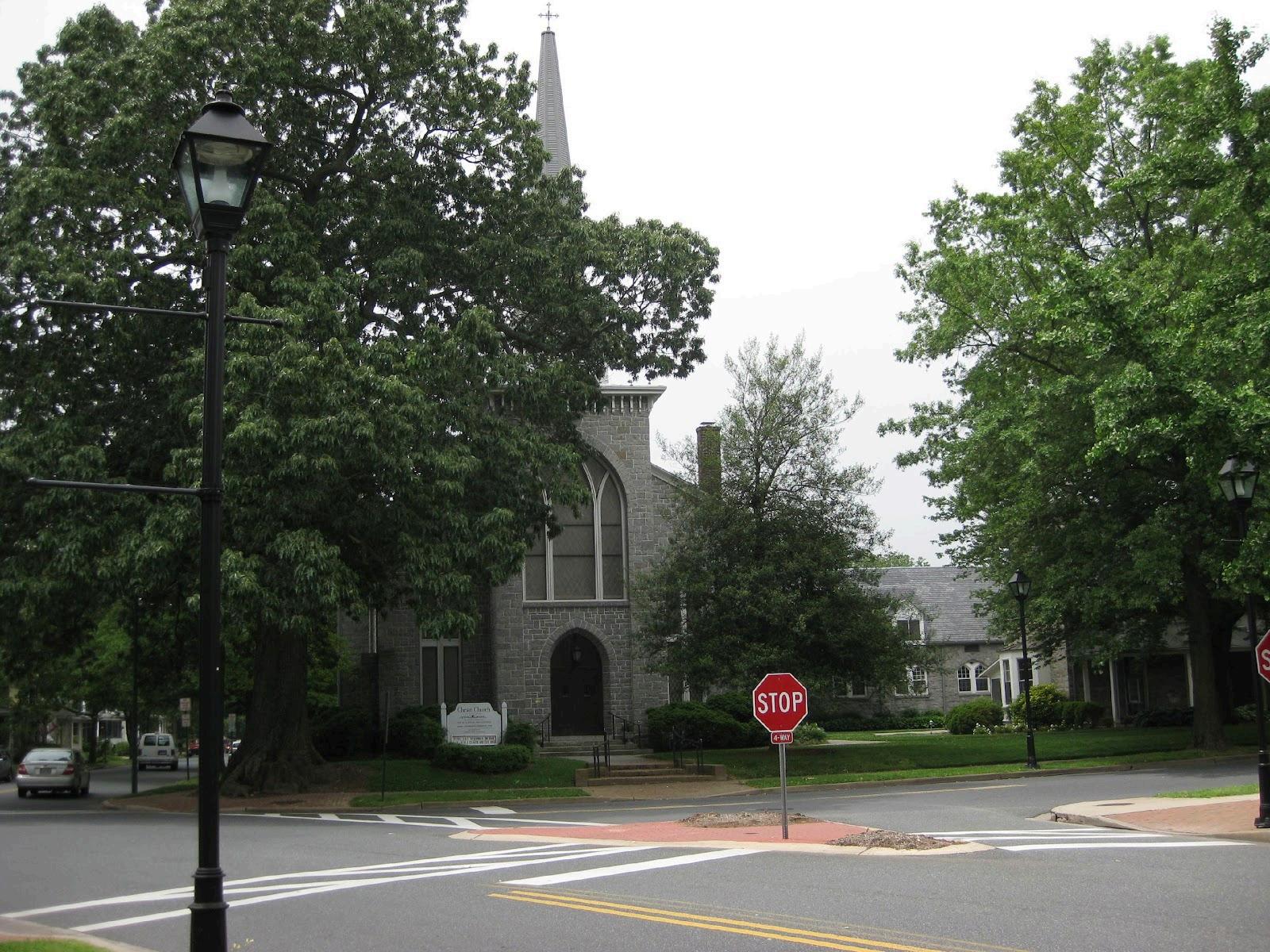
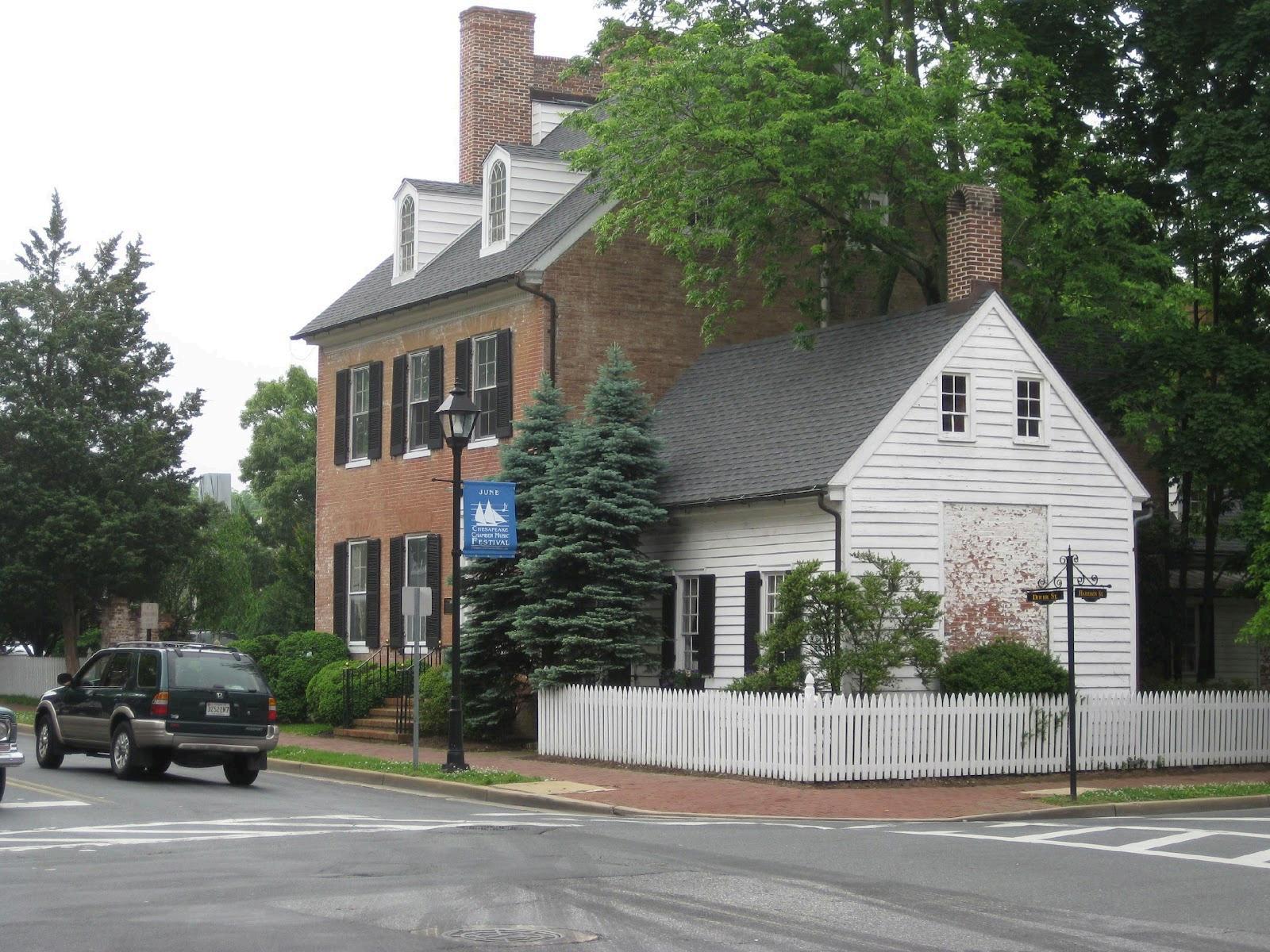
EastonisfrequentlyrecognizedasoneofthebestsmalltownsinAmerica. TheTownisdefinedby itswalkablehistoricdowntown,traditionalneighborhoods,andcompactform.Itscharacteris shapedbyarchitecturalcontinuity,preservedopenspace,andastrongcivictradition Eastonis situatedatthecrossroadsofU.S.Route50andMarylandRoute322,givingitstrategicaccesstothe ChesapeakeBay,Annapolis,Washington,andBaltimore Itsruralsettingandculturalamenities makeitbothadesirableplacetoliveandakeyregionaldestination. Easton’sgrowthoverthepast centuryreflectsitsincreasingroleasaregionalcenteranditsattractivenessasaplacetoliveand invest.
ForanoverviewofEaston’shistoricaldevelopmentandgrowthdynamics,andthatoftheregion,see Appendix1.
ThisPlanisbasedonarangeofdata,analysistools,andpriorstudiesthatprovideafoundationfor itsgoalsandrecommendations. SourcesincludetheU.S.CensusBureau,MarylandDepartmentof Planning,TalbotCountyGeographicInformationSystems(GIS),localinfrastructurecapacitystudies, andEaston’sbuildingpermitandlandusedata.ThePlanalsoincorporatesfiscalanalysistoolssuch asUrban3value-per-acreassessmentstoevaluatedevelopmentpatterns
Takentogether,thesetoolsprovideacomprehensiveandevidence-basedfoundationforlanduse policy,infrastructureplanning,andgrowthmanagement
Onedemographicchangeevidentin(althoughnotuniqueto)EastonisthegrowthoftheHispanic population.,whichmirrorsthedeclineinAfrican-Americanpopulation.Thechartbelowshowshow thesecomponentsofEaston’spopulationhavechangedsince1990whenHispanicswerefirst reportedseparately.ParticularlynoteworthyistheabsolutegrowthintheHispanicpopulationas evidencedbythefactthatwhilethetotalAfricanAmericanpopulationhasbeenverysteadysince 1990,thepercentagethatthisnumberrepresentsofthetotalTownpopulationhasshrunk considerably ConverselytheHispanicpopulationgrowthhasbeendramaticbothinabsolute numbersandasapercentageoftheTown’soverallpopulation(from0.4%to14.4%).
TABLE 1 AFRICAN AMERICAN AND HISPANIC POPULATION CHANGE, 1990-2020
SOURCE : US Decennial Census for Year identified
EastonandTalbotCountyhaveahighconcentrationofpeopleoverage65 In2010Maryland DepartmentofPlanningproducedthefollowingmapillustratingthis:
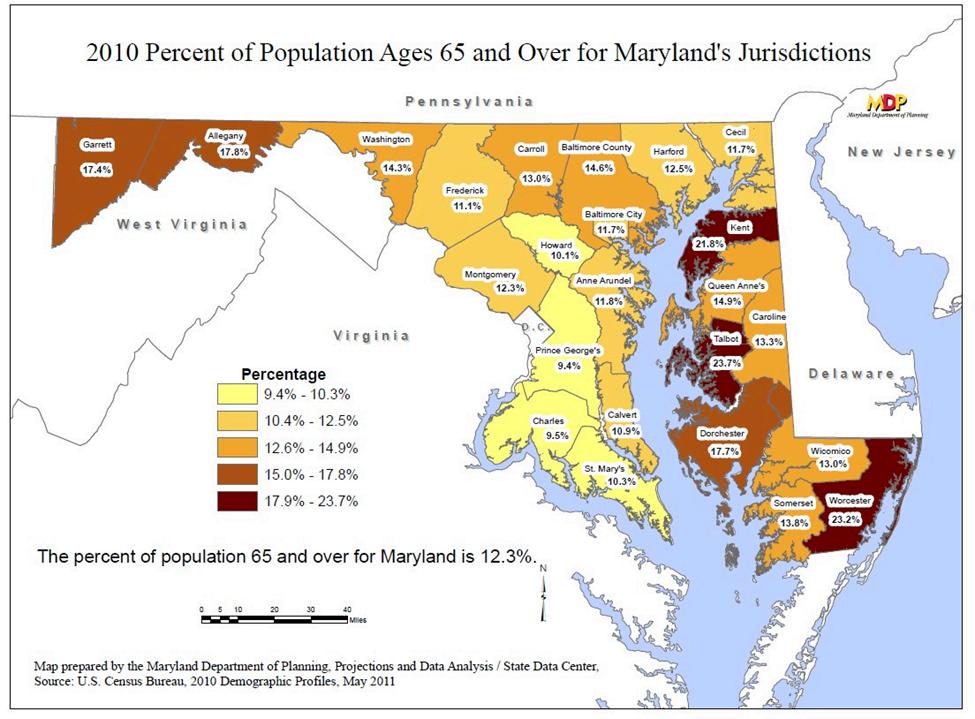
AmericanCommunitiesSurveydatafor2021indicatesthatseniorcitizensremainasignificant portionofthelocalpopulation Itfoundthatwhilethestatepercentageofthepopulationthatwas 65oroverin2021was16.3%,TalbotCounty’swas29.9%andtheTownofEaston’swas24.9%.
WorkonthisComprehensivePlanupdatebeganin2021withareviewofthe2010Plan’s implementationoutcomes Through2022,2023and2024,Townstaffandconsultantsgathered data,conductedmappingandzoninganalysis,andassessedgrowthcapacity.Community engagementbeganin2023andcontinuedinto2024,includingpublicopenhouses,stakeholder workshops,onlinesurveys,andformalpublichearings
Since1997,eachsubsequentupdateoftheComprehensivePlanhascontinuedtorefinetheTown’s growthstrategy,summarizedinthe2010Planas:
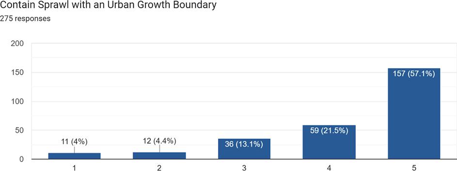
• ContainSprawlwithinanUrbanGrowthBoundary
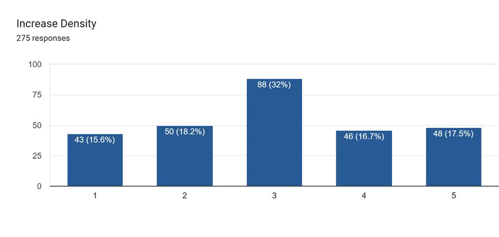
• IncreaseDensity
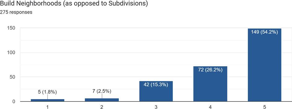
• BuildNeighborhoods
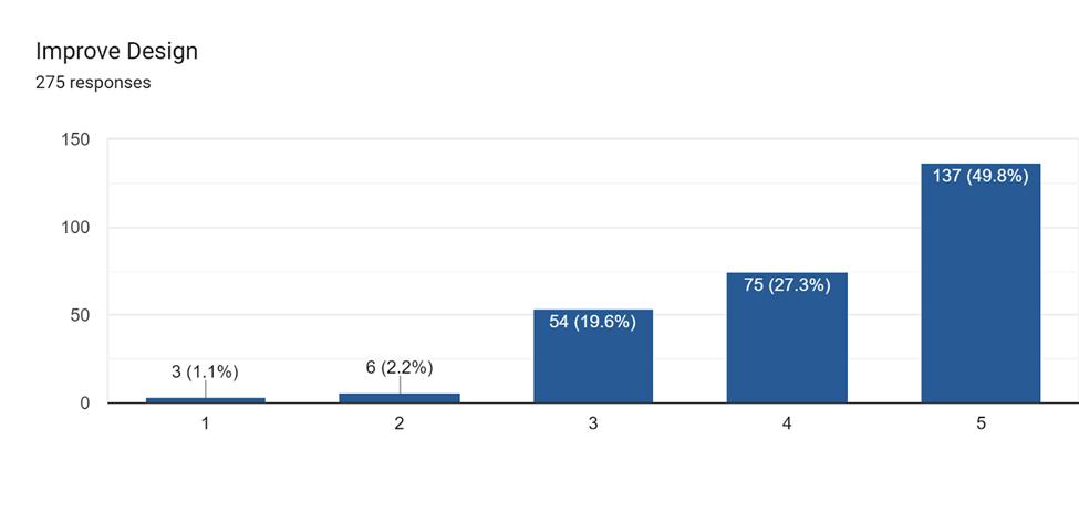
• ImproveDesign
• ManagetheRateofGrowth
The2026Plan2025PlanaddsasixthcomponenttothisGrowthManagementStrategy:
• EncourageMoreSustainableDevelopmentPatterns
Keythemesidentifiedthroughpublicinputincludedtheneedforworkforcehousing,reinvestment inthedowntowncore,trafficandmultimodaltransportationimprovements,protectionof neighborhoodcharacter,andpreservationofEaston’sagriculturalandopenspaceedges.The PlanningCommissionoversawtheprocessandincorporatedcommunityfeedbackintoallmajor chaptersandpolicyrecommendations
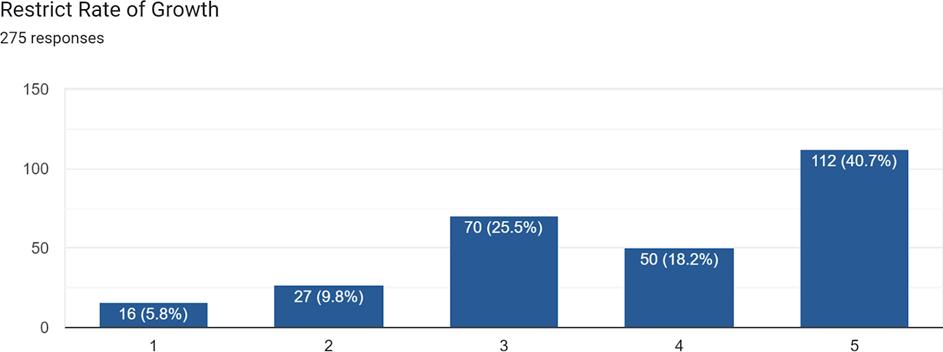
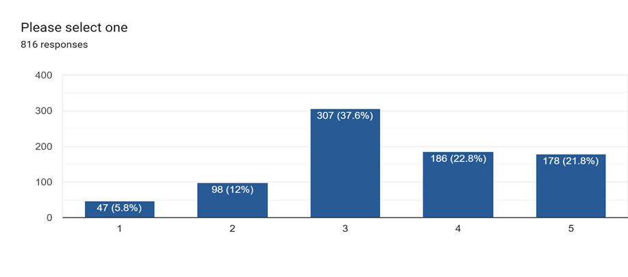
ThecommunityinputphaseofthisPlanUpdateaskedthepublicaboutthecontinuedrelevanceor appropriatenessofeachcomponentoftheGrowthManagementstrategyTheresultswereclear: eachreceivedsomethingbetweenmoderatetoverystrongsupportforcontinuingtobeincludedin thenextPlanningPeriod(2025-2035) Asaresult,thisPlanUpdatebeginswiththepremisethat thereisnodesiretothrowanyofthesestrategiesout.Rather,theobjectiveistobuildonthese ideas,refineandimprovethemwherepossible,andupdatethembasedonnewinformationor issueswherenecessary.Inanutshell,thisisthecontextandspiritofthisPlanupdate. Theresultsof thequestionsaboutTown’sGrowthManagementstrategyaresummarizedinthefollowingcharts (foreachresponse,1=StronglyDisagreeand5=StronglyAgree):
DetailedsurveyresultsfromthepublicoutreachprogramareprovidedinAppendix2.
ThisPlan’sVisionforthefutureofEastoncanbesummarizedas“AReturntoourRoots.”This suggeststhatwedesirethefuturegrowthanddevelopmentofourTowntooccurinamore Traditionalsense,notinthemodernconstructsofsuburbia.Furthermore,weenvisionourTownto continuetofunctionasthemainpopulationcenterofTalbotCountyandoneofthemajorTownson themid-Shore,alongwithCambridge,Denton,Salisbury,Centreville,andChestertown Wewillbea significantplaceofemployment,entertainmentandshopping,butonourscale,notthatofNational Retailers.WehavenodesiretobecomeTHEmajorshoppingdestinationfortheregionstretching fromtheBayBridgetoChestertown,toSalisburyandtheDelawareStateline Wearehappytobe
THEdestinationforthecitizensofTalbotCountyandoneofseveraloptionsforpeopleintheregion describedabove,butnothinggranderthanthat.
The“ReturntoourRoots”themestemsfromourdesiretodevelopmuchmorelikewedidfromour earliestdaysuntilthebeginningofthePostWorldWarIIerathanfromthe1940’sthroughroughly thepresent Wewantthesamekindofdensity,mixoflanduses,andgeneralcharacteroftheearlier daysandwewanttomoveawayfromhomogenoususes,cookie-cutter,massproducedlooking subdivisions,stripdevelopmentalongourhighways,andthegeneral“lookslikeanywhere SuburbanAmerica”.Wewanttobeurban,notsuburban,althoughurbanonanEasternShoreof Marylandscale Tothatend,thischapteristheperfectcompaniontoPlaceElement,wherethis wholethemeisdiscussedingreaterdetail.
ThisVisionandthemeisthesameasthatsetforthinthe2010Plan.Consideringthatintermsof thegrowthoftheTown,littlechangedfrom2010totoday,thismakessense Specifically,in2025, justasin2010,Eastonfindsitselfinaperiodofslowgrowth,withahousingaffordabilityproblem, andwithpublicsupportforouroverallgrowthstrategyInsomewaysthough,itwillbemore challengingtoimplementthisstrategy,giventhatthereareatleastafewfactorsthataredifferentin 2025thantheywerein2010 Thesedifferencesincludetheincreasedseverityofthehousing affordabilityissue,andrecentpurchasesoflargeparcelsoflandbytheTownofEastonandTalbot County,whichwhileadvancinglandpreservation/parksandopenspacegoals,alsoremove hundredsofacresoflandfromconsiderationofpotentialnewhousing
Lastly,thereistheexistenceoftheLakesideatTrappesubdivisionlocatedamerefiveminutesfrom oursouthernmostTownboundaryIn2010,andreallyfordecades,Eastonhasbeen“theonlygame intown”intermsofresidentialdevelopment.Now,thereissignificant“competition”intheformof this2,000unitsubdivision Howthataffectstheabsorptionrateofhomesales(andprices)in Eastonisunknownatthispoint,butpotentiallyasignificantfactorinbothourgrowthstrategyand housingaffordabilityduringthisplanningperiod
Atitsheart,aComprehensivePlanremainsfirstandforemostalanduseplan ThisLandUse Elementprovidesthefoundationuponwhichlaterplanelementsarebased.Itistheblueprintfor thefuturedevelopmentoftheTown TogetherwiththeMunicipalGrowthElement,theLandUse ElementoutlinespoliciesfortheorderlyandplanneddevelopmentoftheTown.
TheuseoflandwithintheTownistheresultofmanyphysical,economicandsocialforces TheLand UseElementreflectsanattemptbytheTowntoequitablybalancetheattainmentofTowngoalsand objectivesfordevelopmentwithprivatepropertyrightsandinterests TheLandUseElement addressesissuesandidentifiesTownpoliciesrelativetoresidential,commercial,andindustrial developmentaswellastheprovisionoflandsforparksandopenspaces.Itanalyzestheappropriate mixofusesintheshortandlongtermgivenprojectedgrowth Itwilladdressreversingand rectifyingwhatarenowviewedaspoorlandusedecisions(madenotjustinEastonbutthroughout thenation)thatweremadeinthepast,primarilysincethelate1940’s Inshort,itlaysthe groundworkthatwillberepeatedthroughoutthePlanforensuringthatfuturegrowthisnotinthe formofauto-centric,isolated,suburbanstylesubdivisionsbutrathertakestheformofmulti-use, integrated,andconnectedneighborhoods.
Atitsfoundingin1710,EastonwaslocatedattheheadwatersoftheTredAvonRiver.Current visitorstoEastonmaywellbeconfusedbythatstatementandwonderwhytheTownmovedfrom thatlocation.ActuallytheTowndidnotmove.Rather,theriverchanged.Itdoesstillexistinthis area,buthasbeenreducedtoastreamthathasbeenenclosedinculvertsinthevicinityof TalbottownShoppingCenterandtheEastonUtilitiesElectricGeneratingPlant.
DirectinggrowthisacriticaltaskfacinglocalgovernmentsthroughoutthecountrytodayMany communitiesviewgrowthasessentialtotheireconomichealth.Communitieswithoutgrowthmay beforcedtocontinuallyraisetaxesonexistingresidentsandbusinessessincethetaxbasedoesnot expand.Ontheotherhand,unchecked,unmanagedgrowthcanalsocausemanyproblems.
Achievingtherightbalanceoflandusesiscriticalinavoidingtheseproblems.Forexample,a communitythatfocusesprimarilyonresidentialgrowthmaybecomeabedroomcommunitywhere theresidentsareforcedtotraveltootherplacesforeverythingfromworktoshopping A communitywithanoverabundanceofcommercialdevelopmentinvitestrafficcongestion.And unlessthecommunityhasadequatedesignstandards,whateverdevelopmentoccursmaynotbe aestheticallypleasing.
Further,aspartofTalbotCounty,Eastonhasbeendesignatedasagrowthareasothattherural natureoftheCountycanbeprotectedandpreservedthroughrestrictivezoning.
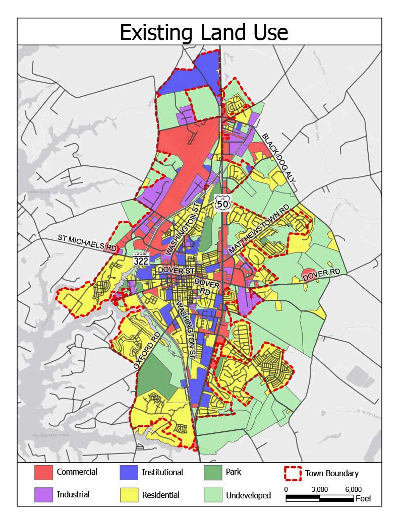
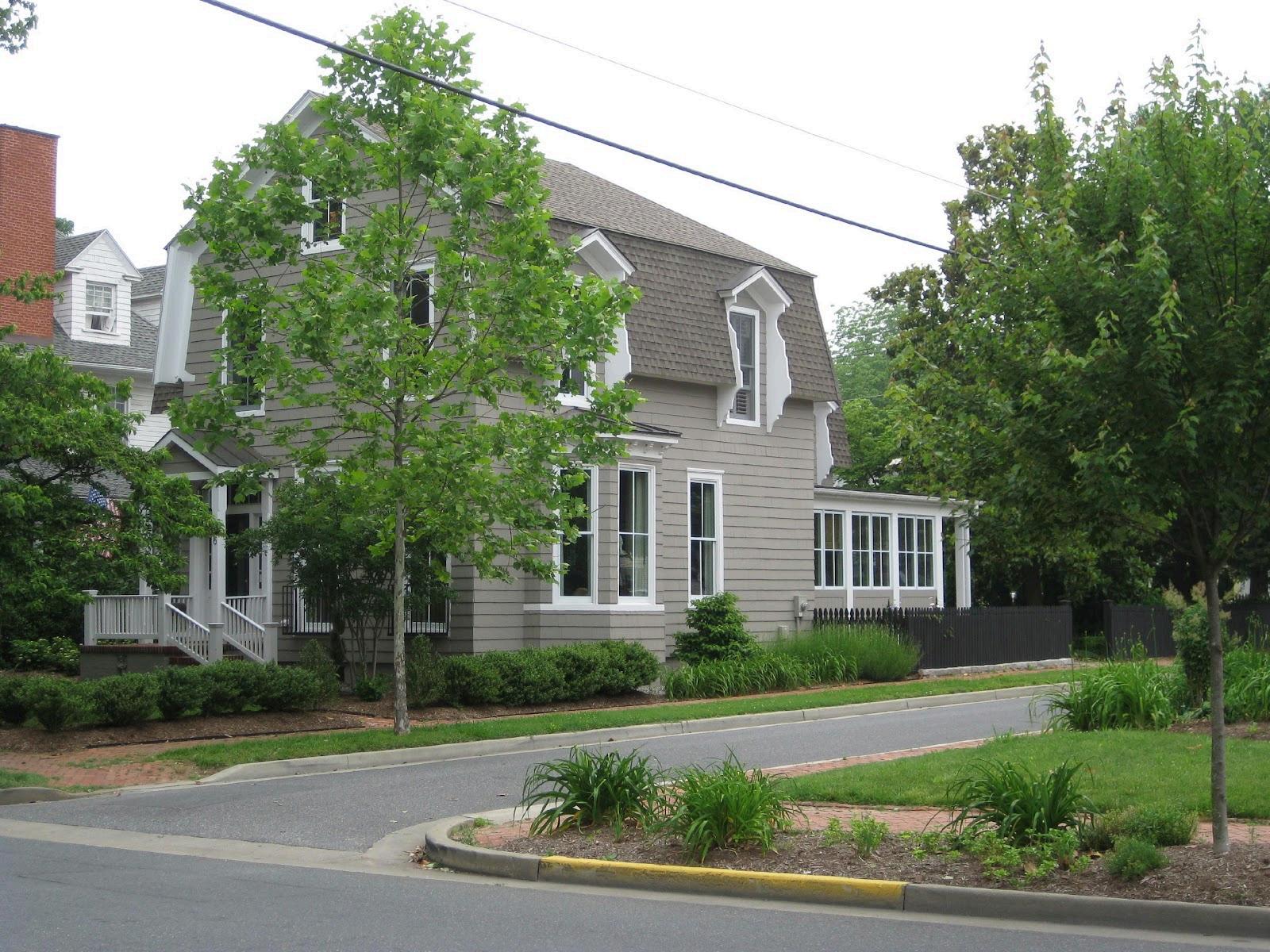
Easton’scurrentlandusepatternreflectsbothitshistoriccompactformandtheevolutionof developmentalongitsedges.Theolderpartsoftownfeaturewalkable,mixed-useneighborhoods withcivic,institutional,andsmall-scalecommercialusesintegratedintotheresidentialfabric. Theseareas,suchasthedowntowncoreandnearbytraditionalneighborhoods,exemplifythekind ofdevelopmenttheTownaimstopreserveandreplicate.
Incontrast,thenewerareasalongtheTown’sfringeexhibitmoresuburban,automobile-oriented patterns.Theseincludelarge-footprintretail,isolatedofficeorinstitutionalcampuses,and conventionalsubdivisionswithlimitedstreetconnectivityInsomecases,landuseandzoning remainmismatched,andlegacyindustrialorunderusedcommercialareaspresentopportunitiesfor reinvestment
Map3isaninsertshowinggraphicallythegrowthoftheTownovertime.Thismapwasfirst includedinthe2004ComprehensivePlanandhasbeenupdatedtoshowchangesovertime.In manywaysthemostinterestingaspectofthisinformationmaybewhathasoccurredsince2004 In short,wefollowedourPlan.Therewereonlythreeannexationsapprovedduringthe2004-2010 Planningperiod ThesameinformationlistingeveryAnnexationthroughouttheTown’shistoryis includedinAppendix3.
TwoofthesewereshownasPriority1GrowthAreasinthe2004Plan Thethirdwasnot,butthere was aComprehensivePlanAmendmentapprovedtomakeitaPriority1Area.Therehavebeen11 AnnexationsthroughoutthecurrentPlanningPeriod,butitisimportanttonotethatithasbeen13 yearsratherthanthepreviouslymandatedsixyearsasaresultoftheamendmenttothatprovision oftheStateLandUseArticle.Notably,allelevenannexedpropertieswereindicatedasPriority1 GrowthAreasinthe2010Plan
Oneotherannexationwasreviewedinthe2004-2010PlanningPeriod,butitwasrejectedbecause thePlanindicatedtheareaasaPriority3GrowthArea,thereforeitwasdeterminedbyboththe PlanningCommissionandtheTownCounciltobeinconsistentwiththePlan.Lastly,oneAnnexation requestwasalsodeniedinthemostrecentPlanningPeriod ThatonewasforaPriority1 designatedarea,butitwasdeniedoverconcernscenteredaroundunknownimpacts(primarily, traffic)thatmightoccurwithfuturedevelopment/redevelopmentofthepropertiesinquestion.
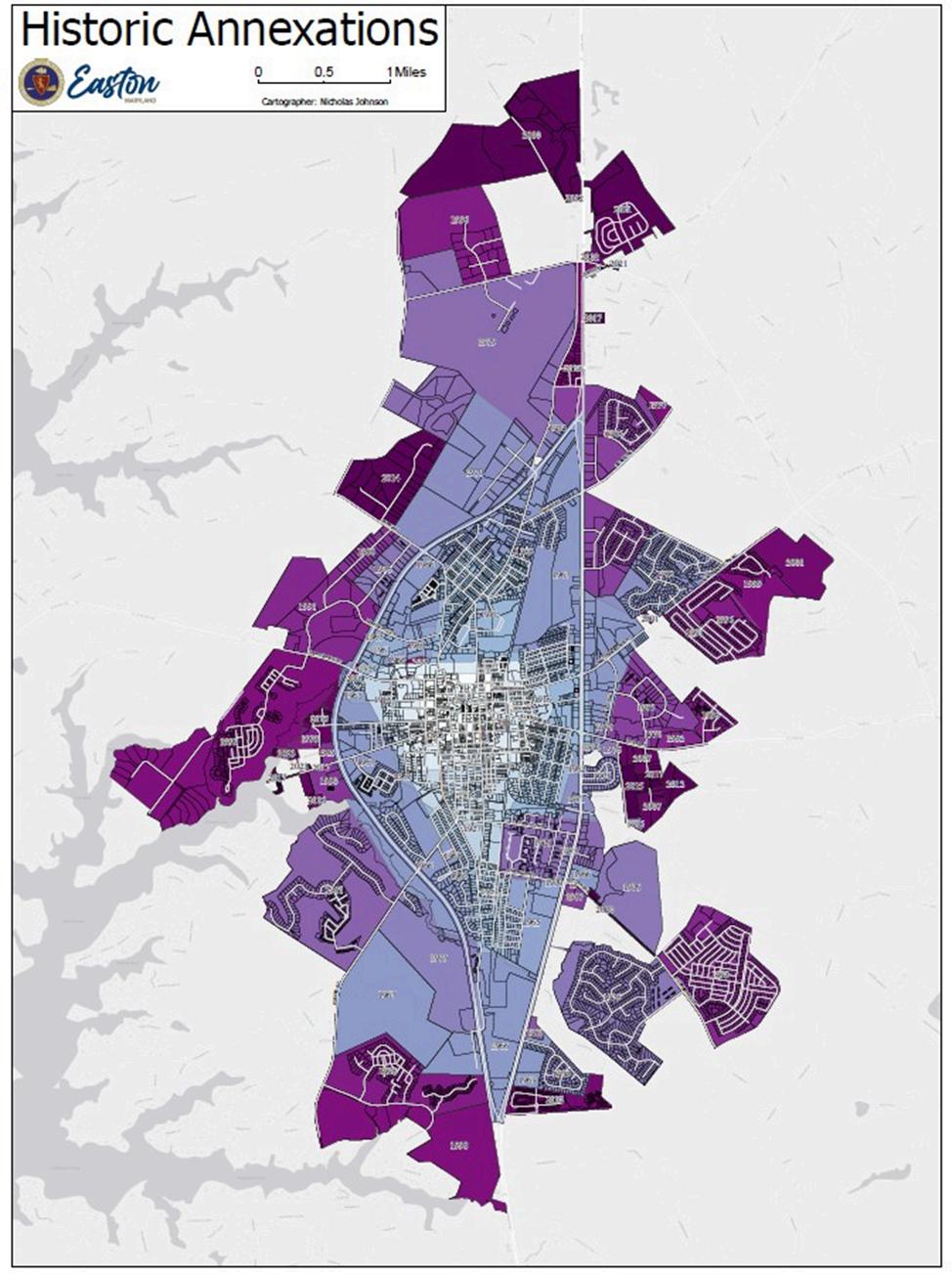
Map 3 - Historic Annexations
Easton’slandusestrategyisgroundedinapracticalunderstandingoflandavailability, infrastructurecapacity,andfiscalimpacts WithlimitedundevelopedspaceremainingwithinTown boundaries,strategicinfillandredevelopmentareessentialtofuturegrowth.TheTown’slanduse goalsremainconsistentwiththecoreprinciplesoutlinedinthe1997and2010Comprehensive Plans:preservingneighborhoodcharacter,maintainingacompactdevelopmentpattern,and focusinggrowthwithinadefinedboundarysupportedbyinfrastructureandpublicservices
Thefoundationforfuturelandusedecisionsbeginswithunderstandingcurrentlandusepatterns.A keyindicatorisshowninthetablebelow,whichpresentstheacreageofeachzoningdistrict establishedunderthe2021ZoningOrdinance,alongwithestimatedamountsofunimprovedland withineachdistrict.
** Not all unimproved acreage is conducive to development, i e environmental factors, open space, etc
Source: Estimates originally prepared by Brent Spicer, Easton Utilities Commission, on January 3, 1994, and updated to include new annexations and rezonings Estimates of unimproved acreage prepared by Current Planner Zach Smith on September 23, 2009 Updated for this Plan by Nicholas Johnson on March 17, 2023
Achievingahealthy,vibrantcommunitydependsonbalance andthefirststepisassessing whetherEaston’scurrentlanduseisalreadyoutofbalance Table7highlightsakeyissue:the limitedsupplyofunimprovedlandwithinTownlimits.Thisconstraintmeansfuturegrowthmust
February 19, 2026
bemetthroughannexationindesignatedFutureGrowthAreas,redevelopmentwithintheexisting boundary,orboth.
Buildoutanalysisconfirmsthatundercurrentzoning,Eastoncanaccommodateonlymodest additionalresidentialandnonresidentialdevelopmentwithoutannexation.Assuch,policiesthat promotehigherdensity,infill,andredevelopmentareessential Inareaswhereinfrastructureexists butcapacityislimited,targetedinvestmentinwater,sewer,andtransportationsystemswillbe necessaryGrowthmustoccurwherepublicsystemscansupportitefficientlyandwherethedesign enhanceswalkability,accesstoservices,andlong-termfiscalsustainability.
The2026Plan2025Planemphasizesthatsustainablelanduseplanningisnotonlyaboutwhere growthhappens,buthow.TheFutureLandUseMapandsupportingpoliciesdirectdevelopmentto areasalreadyservedbypublicinfrastructurewhilediscouraginginefficientsprawlthatburdensthe communitywithlong-termmaintenancecosts
EachlandusecategoryinthePlanreflectsbothfunction(e.g.,residential,commercial,openspace) andexpectationsforform,intensity,andinfrastructurecompatibilityThesecategoriesaimto reinforceplanninggoalswhileallowingflexibilityforcontext-sensitivedesignandpublicinput duringdevelopmentreview
Whilethe2004Planexploredtheidealmixofresidential,commercial,andindustrialuses,the2010 Planomittedthatdiscussion,acknowledgingthesubjectivityofsuchtargets Theoriginalintentwas nevertocapanylandusetype,butrathertoflagimbalances.Atthetime,itwasclear bothfrom dataandpublicinput thatEastonhadsignificantlymorecommercialdevelopmentthantypicalfor atownitssize
Publicinputforthe2026Plan2025Plansuggeststhatimbalancepersists,likelyworsenedbythe nationaldeclineoftraditionalretailandtheacceleratedshifttoonlineshoppingduringthe COVID-19pandemic.Addressingthisimbalancewillrequirethoughtfullandusestrategiesthat reflectmoderneconomictrendswhilesupportingamorediversified,resilientcommunityfabric
PublicinputforthisPlanrevealedwhatseemsatfirsttobeacontradiction:whileEastonis perceivedasover-commercialized,manyresidentsalsoexpressedadesireformorevarietyinretail andfoodestablishments.ThisapparentconflictbeginstomakesensewhenweexamineEaston’s
commerciallandscapebysubcategory.Notallretailisequal,andtheperceptionof over-commercializationislikelytiedtocertaintypesofretail,nottheconceptitself.
Easton’sretailenvironmentcanbebroadlygroupedintofourcategories:NeighborhoodRetail, RegionalRetail,Transient-OrientedRetail,andDowntownRetail.Eachplaysadistinctroleinthe Town’slandusefuture
• NeighborhoodRetail
o Thistypeofsmall-scale,walkableretailisnearlyabsentoutsidetheTownCenter
o MostoOlderneighborhoodsinEastonareexclusivelyresidentialinnatureand overwhelminglysinglefamilydetachedintype. Whereappropriate,amechanism shouldexisttoatleastallowtheconsiderationofsmall,limited-scale,beretrofitted toincludeneighborhood-servingshopstoreinforceasenseofplaceandreducecar dependenceinthesecommunities.
o Newresidentialdevelopmentsshouldintegrate,oratleastaccommodate, neighborhood-scalecommercialuses smallretailnodesattheintersectionof well-definedneighborhoods.
o Planningmustensuresuchretailremainsneighborhood-servinginscaleanddoes notevolveintobroadercommercialcenters.Properlylocatedandscaled, neighborhoodretailcanreducelocaltrafficratherthanincreaseit.
• RegionalRetail
o ThisisthedominantretailforminEastonandtheprimarycontributortoits unusuallyhighpercapitaretailspace estimatedat80squarefeetperperson, roughlydoublethelevelrecommendedinthe2004Plan
o Itisalsothemostfrequentlycitedconcerninpublicfeedbackabout over-commercialization.
o Futureregionalretaildevelopmentwillbelimitedto:
▪ Undevelopedcommerciallyzonedland,
▪ Redevelopmentofexistingshoppingcenters.
o NoexpansionofregionalretailareasisproposedintheFutureLandUseMap.
o Anynewregionalretailmustcomplywithstrictdesignstandards.Donewell,itcan reinforcelocalcharacter;donepoorly,itrisksmakingEastonindistinguishablefrom “Anywhere,USA”
• Transient-OrientedRetail
o Thiscategoryincludesgasstations,fastfood,andquick-serviceretailthatserve through-trafficaswellasresidents
o Whilenewgrowthopportunitiesarelimited,redevelopmentpotentialis strong especiallyalongRoute50.
o Thisretailtypeisvaluedbyresidentsandworkersforitsconvenience(eg,lunch spots,fuel)
o Likeregionalretail,itrequirescarefuldesignregulationtoimproveEaston’svisual characterandavoidcorridorsprawl.
o Futureexpansionwillfocuson:
▪ ImprovingundevelopedcommercialsitesneartheTown’snorthernedge,
▪ RedevelopmentalongtheRoute50corridor.
• Downtown(TownCenter)
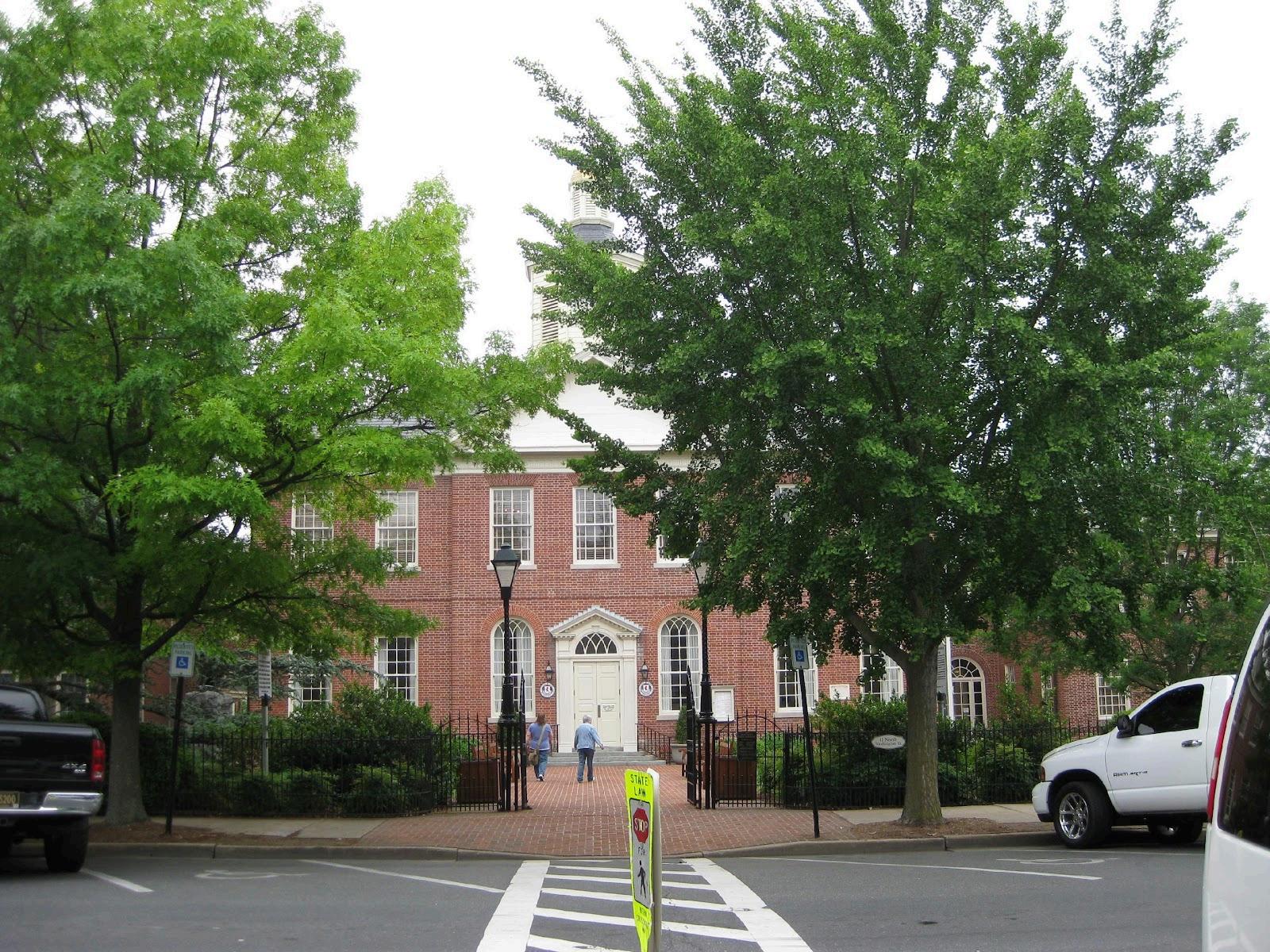
o Easton’sDowntownistheheartofthecommunity,withitshistoricbuildings, governmentoffices,thecourthouse(datingto1794),theAvalonTheatre,museums, restaurants,inns,andspecialtyshops.
o Whilespacefornewdevelopmentislimited,thereareopportunitiesfortargeted redevelopmentandinfill
o APlanforDowntownRedevelopmentandInfill,adoptedin2009,guidesthiswork andisdiscussedfurtherintheEconomicDevelopmentchapter.
o PreservingandstrengtheningexistingbusinesseswillbekeytokeepingDowntown vibrantandmaintainingEaston’suniquecharacter.
Easton’sperceivedover-commercializationstemslargelyfromanoversupplyofregional-scale retail.Atthesametime,residentsareaskingformoreneighborhood-serving,diverse,andvibrant commercialexperiences,especiallyinunderservedpartsoftown Futurelandusepolicyshould supportabalancedcommercialmix,regulatescaleanddesign,andencouragedevelopmentthat reinforcesneighborhoodidentityandlocalcharacter
Table2summarizesthesecommercialretailtypes.Forpurposesofcomparison,“Neighborhood” alignswiththecategorydescribedabove,while“Community”and“Regional”fallunderthebroader discussionofregionalretail.
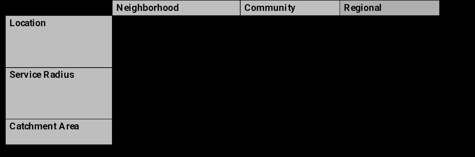

Source: Adapted from Urban Land Institute (1982); Lynch and Hack (1984); Leung (1989)
ResidentialLandUsesaregenerallynotdescribedintermsofaratio Infact,tothecontrary,the needsoftheotherlandusesareoftenprojectedbasedonratiosinvolvingthenumberofresidential
units(orpopulation)inthecommunity.Thediscussionaboutresidentiallandusestendstofocus moreonthearrangement,appearance,variety,anddensityofthislanduse.Thatisdiscussed thoroughlyinthePlaceandHousingElements Sufficeittosaythatwecontinuetoseethings changingforthislanduse.WedonotenvisionthefutureofEastonasaseriesofdisconnected, isolated,monotonoussubdivisions Ratherwewanttoseeaseamless,attractive,interesting, SustainableGrowthinspiredEaston;oneEaston,notacollectionofsuburbanresidentialenclaves.
Thediscussioninthe2004Plandidnottalkaboutaratioofindustriallandacreageorsquare footagetoresidentialunits,butrathertalkedaboutjobstohousingratio.Forthislanduse,the2004 PlanconcludedthatthereweremorejobsinEastonthanthepopulationwouldsuggestisnecessary. However,asthe2010Plannoted,therewereanumberoffactorsthatskewedthisestimate These included:
• alargeproportionofEaston’spopulationisretired-therearealotofdwellingunitsfor whichnojobsarenecessary
• ashiftinginthefocusofjobsawayfromthemanufacturingandtraditional“industrial”type jobstowardsservice-orientedjobs
• tourismhasbecomemoreimportantinEastonandmorejobsarefoundinthefoodand hospitalitysectorsofthejobmarket
• EastonisthegovernmentalcenterofTalbotCounty–thisresultsinmanygovernmentjobs, aswellasjobsinalliedprofessionssuchaslegal,realestate,accounting,surveyingand engineering,etc.
• AsthelargestcommunityontheMid-Shore,Eastonisahubformedicalservices, entertainment,retail,etc.
• EastonservesasanemploymenthubforamuchlargerareathanTalbotCounty
The2010Planstated“Itisclearthattherehasbeenagradualerosionoftheavailabilityof this[industrially-zoned]landforclassicindustrialusesbyallowingmoreandmorecommercialand serviceuses.”ChangesweremadetotheTown’sZoningRegulationsinrecognitionofthisissue. Also,apartiallydevelopedIndustrialPark(TalbotCommercePark)wasannexedintoTowninthis Planningperiod,toprovideTowninfrastructure,whichhasaccelerateditsbuild-out.Finally,in responsetothisdiminishingsupplyofindustrialproperty,theTownobtainedaUSDepartmentof
CommercegranttoextendandinstallutilitiestotheTown-ownedMistletoeHallproperty, facilitatingitsdevelopmentasaCommerceandBusinessPark.
ManyofthejobsinEastonarefilledbyresidentsofjurisdictionsotherthanEaston,impactingour transportationsystem.TheothersideofthecoinofhavingsomanypeoplecommutingintoEaston forworkisthefactthatmanyEastonresidentsarecommutingoutoftowntowork Thus,jobs whichbettermeettheneedsofEastonresidentswouldbeofgreatbenefitinreducingtrafficandthe associatedenvironmentalimpacts Forthisreasonspecificallythereareindustrialareasproposed ontheeasternsideofTownfordevelopmentinthelong-rangeplanningperiod.
ThebenefitsofmixedlanduseswillbearecurringthemethroughoutthisPlan,particularlyinthe PlaceandTransportationElements.Inshort,mixeduses:
• Increasehousingoptionsformorediversehouseholdtypes
• Providemoretransportationoptions.
• Reduceautomobiledependence
• Createatruersenseofplacethansingle-usesuburbanstyledevelopment.
• Activatesurbanareasthroughoutmoretimesoftheday
• Providegreateropportunityforsocialinteraction.
• Reduceacommunity’scarbonfootprintbyencouragingwalkingandbikingasanalternative toautomobileuse.
• Increasethesafetyoftheneighborhoodbyputtingmoreeyesonthestreet
The2026Plan2025Planaddsgreateremphasisonsustainability,fiscalefficiency,and redevelopment Landusepolicyisincreasinglytiedtoinfrastructureinvestment,publicspace, transportationnetworks,andeconomicproductivity.Newfiscaltools,includingvalue-per-acre modeling,helptheTownassesswherelandusepatternsgeneratelong-termpublicvaluerelativeto cost
i. Rethinking Zoning and the Built Environment
Muchhasbeenwritteninrecentyearsaboutthe“sins”ofmodernplanningandthefailuresofthe builtenvironmentinmanyAmericancommunities MovementslikeSmartGrowth,NewUrbanism, andNeo-TraditionalPlanningemergedinresponsetodevelopmentpatternsthatsacrificed livability,character,andsustainabilityinfavorofautomobile-dependentsprawl
Sprawlhasbeencharacterizedbylow-density,single-usedevelopment;monotonoussubdivisions; congestedroads;andthelossoffarmlandandforests Thesepatternsstandinstarkcontrasttothe compact,walkable,mixed-useneighborhoodsthisPlanseekstopromote.
1. How Did We Get Here?
Amajorreasonfortheseoutcomesliesintheverytoolsusedtoregulategrowth mostnotably, zoning.Whilezoningwasoriginallyintendedtoprotectpublichealthandsafety suchas separatinghousingfromnoxioususes ithasevolvedintoarigidsystemthatover-segregatesland usesandsuppressestheintegrated,mixed-usedevelopmentpatternsoftraditionaltowns.
Therootsofzoningdatebackto1867inSanFrancisco,withbroaderadoptionfollowingthe landmark1926SupremeCourtdecisioninVillageofEuclidv.AmblerRealtyCo.,whichupheldthe constitutionalityofzoning.Sincethen,thetoolhasbecomeubiquitous butnotwithout consequences
InEaston,asinmanyplaces,zoninghastoooftendiscouragedtheverytypesofcommunitieswe value Wideseparationofuses,minimumlotsizes,andrestrictivecodeshavemadecar-dependent subdivisionsthedefault.Thetimehascometorethinkthismodel.
Notentirely.Zoningstillhasaroleinprotectingresidentsfromheavyindustryandincompatible landuses.However,EastonshouldreformitsZoningOrdinancetoencouragemixed-use,walkable, andhuman-scaledneighborhoods especiallyinundevelopedareaswithintheTown’sGrowth Area.
Forexample,commercialusesandworkplacesthatarecompatiblewithnearbyhousingshouldnot beexcluded.Residentialdensitiesshouldbeincreasedandminimumlotsizesreducedtosupport moreefficientandlivableneighborhoods Ataminimum,newdevelopmentshouldmeettheState’s
SmartGrowthPriorityFundingAreathresholdof3.5unitsperacre(net) withhigherdensities encouragedinappropriateareas.
In2024,thePlanning/EconomicDevelopmentFirmUrban3modelledthefiscalimpactsoflanduses ontheEasternShoreingeneral,andtheninTalbotCountyspecificallyThebasisofUrban3’s methodologyinvolvesexamining“valueperacre”fortheareabeinganalyzed.Thefindingsofthis effortaresummarizedmorethoroughlyintheSustainabilityChapterofthisPlan Afullcopyofthe reportcanalsobefoundontheEasternShoreLandConservancy’swebsite,at: https://www.eslc.org/urban3/. FromaLandUseperspective,sufficeittosaythattheUrban3 studysuggeststhatthefiscalsustainabilityofdevelopmentpatternsisyetanotherreasonto supportfuturedevelopmentofaTraditionalNeighborhoodformasopposedtothesuburban archetypethathasbecomemoreprevalentoverthecourseofthepastfiveorsixdecades
ThisPlanorganizesEaston’sfuturegrowthintoaseriesoflandusecategoriesthatdescribethe generalpattern,scale,andintentfordevelopment.Thesecategoriesguidezoningdecisionsandhelp ensurethatgrowthoccursinappropriatelocationsandforms.WhilethisPlanisnotazoningmap,it providesthefoundationforfutureamendmentstotheZoningCodeandSubdivisionRegulations
Futurelandusedesignationsarenotintendedtobeparcel-specificorregulatory.Rather,they provideageneralizedvisionforhowareasoftheTownshouldevolveovertime Zoningchangesand siteplanapprovalswillbeguidedbythesedesignationsbutmustalsoconsidercompatibility, capacity,anddesignquality
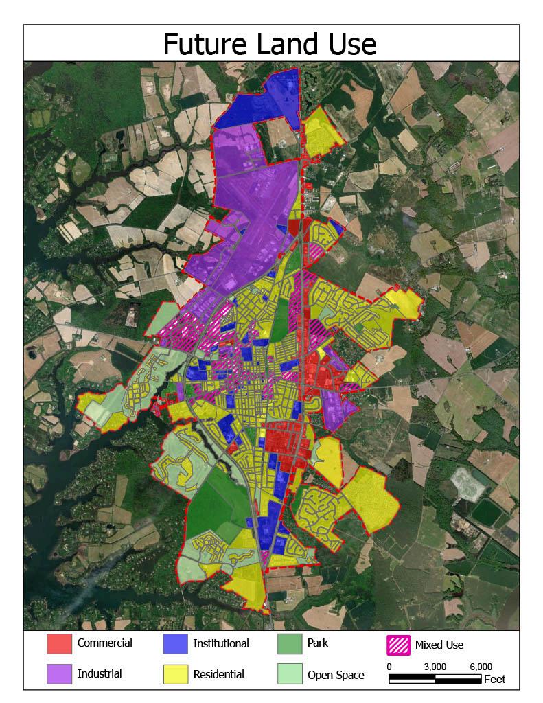
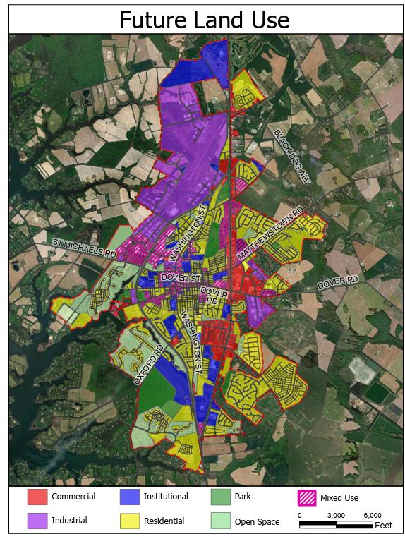
TheFutureLandUseMapcontainedanddescribedmorethoroughlyintheImplementation Element,providesagraphicrepresentationofthedesiredpatternoflanduseswithintheTown
TheFutureLandUseMapidentifieswhereresidential,commercial,mixed-use,openspace,and institutionaldevelopmentisanticipated Theseareasaretiedtoinfrastructurereadiness,accessto services,andtheirabilitytosupportcompleteneighborhoods.
ThereisoneproposedadditiontotheoveralllimitsoftheTown’sFutureGrowthArea. Duringthe courseofthepastplanningcycle,ithasbecomeincreasinglyapparentthattherewouldbe advantagestohavingtheTown-ownedpropertythatisthesiteofourWastewaterTreatment
FacilitytobelocatedwithinTownBoundaries. ThiswouldrequireAnnexationandinorderforany futureAnnexationtobeconsistentwiththisPlan,thelandforsaidannexationneedstobeincluded inourFutureGrowthArea. Thus,thisPlanproposestoexpandtheGrowthBoundarytotheeast fromitspresentlimittotheWWTPsite. TheonlyadditionallandbesidestheWWTPthatwouldbe broughtintotheGrowthAreaasaresultofthischangewouldbeSethForestandthebedof ChesapeakeAvenueasitpassesalongthesouthernborderoftheproperty. Giventhatthese propertiesareState-ownedandTown-owned,andthepurposeforwhicheachisused,thereis essentiallynopossibilitythatsuchanactionwouldincreasethedevelopmentpotentialofthe FutureGrowthArea.
SeeTable2onpage18 fordetaileddefinitionsandacreagesummariesbyzoningcategory.
TheFutureLandUseFrameworkincludesseveralkeydistrictsthatserveasfocalpointsforthe Town’sidentityandgrowthstrategy.Theseinclude:
● DowntownEaston–walkable,civicandculturalhubwithmixed-usedevelopment
● EastEnd/DoverRoadCorridorGateway–commercialnodewithopportunitiesforinfilland street-frontredesign
● PortStreetCorridor–targetedforredevelopmentwithhousing,employment,andcivic amenities
● HospitalDistrict–medicalandinstitutionalanchor,withsupportiveresidentialandcommercial uses
● PoplarHillFarm-120acreparcelpurchasedbyTalbotCountyin2025 Formerlyviewedasa keysiteforfuturegrowth,itisdesignatedforInstitutionaluse,reflectingitsownershipbythe County Thiscouldmeanahostofthings,includingactiveorpassiveparksand/ornewCounty governmentfacilities. Itisalsolargeenoughthataportioncouldbesubdividedandsoldfor privatedevelopmenttoraisefundsforthegovernmentaluseofthebulkoftheproperty.Ifso, theappropriateuseinthislocationwouldberesidential, althoughaverysmall-scale commercialormixed-usecomponenttoservethenumerousstrictlyresidentialdevelopmentsin
thearea(e.g.,Cooke'sHope,ThreadHaven,and now,effectively(withtheclosureofthe restaurantandClubHouse),EastonClub.
Thesedistrictswillbenefitfromtargetedplanningefforts,includingsmallareaplans,design guidelines,andinfrastructureinvestments
OfparticularimportancethisplanningcycleistheHospitalDistrictandactually,therearetwo. One isthelocationofthecurrenthospitalandthesecondisthelocationofthenewfacilitynowunder activeconstruction.TheHospitalrelocationandexpansiontothenorthernendoftheTown’s GrowthArearequiresspecialconsiderationofanumberoffactorsorissues,including:
● Whatisthemostappropriatereuse/redevelopmentofthecurrenthospitalsite?
● WhatisthelikelyfutureforthevariousmedicalfacilitieslocatedonDutchman’sLaneand IdelwildAvenue? Dotheyeventuallyrelocateclosertothenewfacility? Ifso,whenisthis likelytooccur? Whatthenisthemostappropriateuse/reuseofthesefacilities?
● ThenewhospitalsiteisremotefromtherestofTownandsurroundedbyundevelopedland, anindustrialpark,andtheTalbotCommunityCenterandassociatedrecreationalfacilities. Giventhis,whatisthemostappropriatelandusefortheunimprovedparcelssurrounding andincloseproximitytothenewhospital? Howcanthenewhospitalbebetterconnected andintegratedwiththebulkoftheTownofEaston?
ThefollowinggoalsandobjectivesguideEaston’sfuturelandusepolicyThesereflectthevisionand valuesadoptedinthe2026Plan2025Planandbuildonthefoundationsestablishedin2010and earlier
Goal #1: Limit the geographic outward expansion of Easton.
Objectives:
● ReaffirmthecurrentUrbanGrowthBoundary(UGB)anduseittoguideannexationand utilityextensions
● CoordinatewithTalbotCountyandvariouslandpreservationandenvironmentally-aligned organizationstosecureeasementsandotherlong-termprotectiondevicesonproperties alongandincloseproximitytotheUrbanGrowthBoundaryontheCountysideoftheline
● Establishannexationpoliciesthatincludecriteriafordevelopmentreadiness,consistency withtheComprehensivePlan,andexpectedphasingorpacingofgrowth.
● Exploreincentiveannexationtogaincontroloflandonthetown’sborderthatmighthave previouslybeendevelopedunderTalbotCountyrulesandregulationstofacilitatemore appropriateredevelopmentorexpansiononsuchparcels
● Slowthedemandformorelandbyincreasingthedensityoffutureresidentialareas.Ata minimum,theStateofMaryland’sminimumacceptabledensityforqualificationasaPriority FundingAreaof3.5units(net)peracreshouldbeachievedinthesedevelopments.
● ConsideradoptionofanAdequatePublicFacilitiesOrdinance(APFO)iftherateofgrowthis exceedingthecurrentorplannedcapacityforspecifictypesofinfrastructure.
● FollowaCapitalImprovementProgramwhichwillallowtheTowntoprovidearational basisforimplementingimprovementsandincreasefundingopportunities,inaplanned mannertolocationswheregrowthmaybeprioritized
Goal #2: Make Easton more walkable and connected / achieve a more balanced and integrated mix of uses.
Objectives:
● Encouragedevelopmentpatternsthatpromotewalkability,includinghigherdensities, mixed-useareas,andtraditionalneighborhoodform.
● Supportneighborhood-scalecommercialdevelopmentandlive/workspacesthatreducethe needforautomobiletrips
● Improvepedestrianandbicycleinfrastructureandensureitisincludedinallnew developmentandredevelopmentprojects
● Encourageconnectionsbetweenneighborhoodsandcommercialareasthrougha fine-grainedstreetnetworkandactivetransportationroutes
● “Retro-fit” Considerallowingdiversificationoflanduseswithinolder,developed subdivisionsinsubdivisionswithinthroughtheTownbyadditionaddionof ngsmall, neighborhood-scaleretail,civicandopenspaceelementstoexistingresidential subdivisions
● AmendtheTown’sZoningOrdinancetochangethefocusfromregulationbybuildinguse,to buildingtypeandsiteimpact.
● SimplifytheprocessfordeveloperstoachievetheTown’sobjectives
Goal #3: Use land efficiently and sustainably.
Objectives:
● PrioritizeinfillandredevelopmentofvacantorunderutilizedsiteswithintheTown’s boundary.
● Balancenewdevelopmentwithinfrastructurecapacity,usingwater,sewer,transportation, andstormwaterdatatoguidelandusedecisions.
● Usefiscalmodelingtools,suchasvalue-per-acreassessments,toevaluatethelong-term sustainabilityofproposedlandusechanges
● Discouragelow-densitydevelopmentatthefringeofTownthatgenerateshigher infrastructurecostsandunderminescompactgrowthgoals
● Exploreoptionstoexpeditepermitapprovalsforpermittedusesifextraordinarydesign improvementsareincluded
“WE SHAPE OUR BUILDINGS AND AFTERWARD OUR BUILDINGS SHAPE US. ”
–WinstonChurchill
ImprovingthequalityofEaston’sbuiltenvironmenthasbeenacentralgoalsincetheTownadopted Vision-basedPlanninginthe1997ComprehensivePlan.Sincethen,theTownhastakenmultiple stepstoelevatedevelopmentstandards Itaddedsiteplanningandarchitecturalrequirementsfor specificuses,upgradedlandscapingstandards,overhauledsignregulations cuttingfreestanding signheightinhalf andimposedsizeandstrictdesignlimitsonbig-boxretailandshopping centers Townofficialsalsobeganopposingformulaic“corporate-franchisearchitecture,”as recommendedinthe1997Plan.
The2004Planreaffirmedtheneedforhigherdesignstandardsandextendedthefocusfrom commercialtoresidentialdevelopment,culminatingintheadoptionofDesignGuidelinesforNew Construction The2010PlanupdatedEaston’sdesignprinciples,revisingseveralandaddingone newprinciplebasedonobserveddevelopmenttrends.ThisPlancontinuesthatprocess,proposing additionalrefinementsbasedonthepast15yearsofexperienceandpublicfeedback.
Thischapteralsorevisitsthetopicofbig-boxretail alongstandingconcernsincethe1997Plan, whichwasamendedin2000toaddresstheissuedirectly.Itfurtherexploreshowzoningshapes Easton’scharacterandproposeswaystomodernizeoutdatedzoningandsubdivisiontools In particular,itrevivestheconceptof“TraditionalNeighborhoodDevelopment” firstproposedin 2004butnotpursuedin2010 asaviableframeworkforfuturegrowthareas Finally,itexpands theTown’sGrowthManagementPolicytoemphasizetheimportanceofbothinfilland redevelopment,withnewrecommendationstoensurecompatibilitywithexistingneighborhoods
TheHistoryoftheTownischronicledintheBackgroundChapterofthisPlan Animportantpartof whatmakesEastonsouniqueandsospecialisthenumberandqualityofhistoricbuildingsand settings. Thissubsectiontalksabouttheimportanceofthesehistoricandculturalresourcesand makesrecommendationsforhowtheycanfurtherbeprotected
ThehistoryofEastoncanbeseeninitshistoricbuildingsandneighborhoodswhichdatebackover severalcenturies. PhysicalremindersofearlyhistorygivedepthandrichnesstotheTown,topast events and to people’s lives. Easton has a substantial and well-documented stock of historic structures, streetscapes, sites, and settings. Some944parcelsintheHistoricDistricthavebeen surveyedanddocumented Preservationandrehabilitationofthesestructuresandstreetscapesenhancesthehistoriccharacter of the town, stabilizes neighborhoods, protects property values, and attracts visitors toEaston Continued historic preservation will provide Easton with a number of aesthetic and economic benefits,including:
▪ Promotionofastrongsenseofcommunityprideandtradition;
▪ Community revitalization through the restoration and adaptive reuse of older structures;
▪ Increasedpropertyvaluesandtaxrevenuesasaresultofrenovationandrestoration; and
▪ Increasedrevenuesfromtourismactivitiesgeneratedbyaninterestinhistoricbuildings andsites.
Inawaythat’smoredifficulttoquantify,historicpreservationallowsthelegacyofthepasttobe protectedandremembered;itallowsforthepasttobeintegratedwiththepresentandremindsus thattheoldhasausefulplacealongsidethenew.
Easton recognizes the importance of its historic resources and supports and encourages preservationandrehabilitationeffortsbyprivateowners,nonprofitsandlocalgovernments.Private housesandpublicbuildingsareoftencarefullyrestored Newusesarefoundforhistoricbuildings which no longer serve their original functions. The preservation of historic buildings and structures includes consideration of the integrity of the location, neighborhood, design,setting, materials and workmanship. As more and more focus for future growth is on infill and redevelopment opportunities, such adaptive reuse ofhistoricbuildingswillbecomeincreasingly prevalentandimportanttomaintainingthehistoriccharmandauthenticityoftheTowningeneral, andthehistoricdistrictspecifically.
The“StoriesoftheChesapeake”CertifiedHeritageAreaencompassesheritagesitesandplacesin Talbot and adjacent counties which were designated a certified heritage area by the Maryland HeritageAreaAuthorityonApril20,2005 ThisprogramrecognizesEastonasofferinganumberof heritageresourcesofimportancetotheregion.
Eastonisalsoa“TargetedInvestmentZone”,astatedesignationthatpermitsthetowntogetstate financialsupportforacertifiedheritagearea.
The NationalRegisterofHistoricPlaces,aninventoryofhistoricresources,ismaintainedbythe National Park Service. Listing in the National Register provides recognition to sites, buildings, structures,objects,anddistrictsthataresignificanttoAmericanhistory,architecture,archaeology, engineering,orculture. AnEastonNationalRegisterHistoricDistrictwassurveyed,nominated,and approved in 1980 In addition to providing recognition of significance, listing in the National Register mandates consideration in the planningofanyfederalorfederally-assistedprojectand provideseligibilityforfederalandstatetaxcreditsforhistoricpreservationprojects.
TheTownhasaHistoricDistrictCommissionandhastwomuseums,(theAcademyArtMuseumand theHistoricalSocietyofTalbotCountyMuseum).ItalsohasthehistoricAvalonTheatrewheremany culturalandcommunityeventstakeplace. TheEastonHistoricDistrictwascreatedinthelate70s andexpandedin2005.Theseven-memberHistoricDistrictCommissioniscomposedofvolunteer citizens with interest or specific expertise in historic preservation and appointed to three-year termsbytheMayor.TheCommissionreviewsproposedexteriorchangestoanysite,structure,or appurtenance in the defined district, according to an approved andpublishedsetofguidelines, whichwererecentlyupdatedbytheCommission Inadditiontothereviewofproposedprojects, inclusionintheHistoricDistrictalsoprovideseligibilityforastatehistoricpreservationtaxcredit to property owners who undertake historic preservation projects, whether or nottheproperty producesincome.
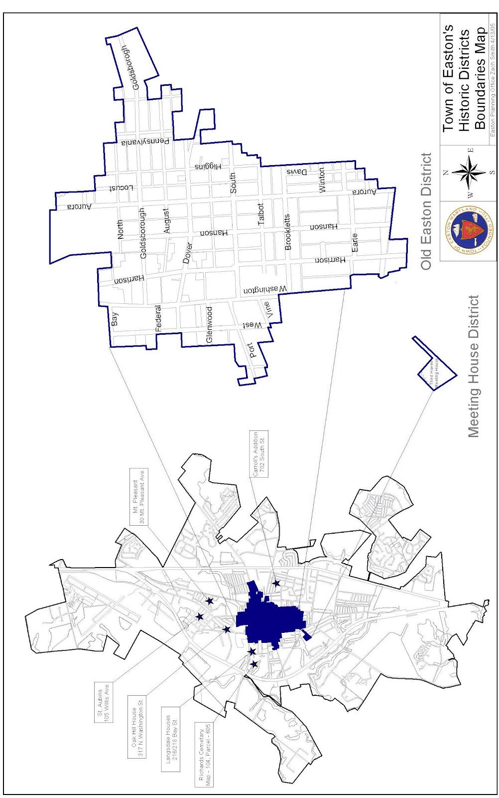
AspecificissuethatrequiresspecialattentionintheHistoricDistrictingeneralandintheHill neighborhoodspecifically,isgentrification.TheHillisasmallneighborhoodwithintheHistoric District.ItssignificancecannotbeoverstatedandisperhapsbestdescribedontheHistorical MarkerrecentlyplacedneartheRail-TrailandDoverStreetintersection Itstates:
“Foundedin1788,theHillisoneoftheoldestfreeAfricanAmericanneighborhoodsintheU.S.still inexistencetodayManyAfricanAmericansinEastonandTalbotCountywerefreefromslaverylong beforetheCivilWarended.Freepeopleofcolorlivedalongsidewhiteneighbors,workingas merchants,sailors,carpenters,midwivesandfarmlaborers Theyworkedtobuyfreedomfortheir relativeswhilepursuingfullequalityandlibertyforthemselves.”
Unfortunately,TheHillalsohappenstocontainmanyofthestructuresmostinneedof repair/rehabilitationinEaston.Publicandprivateeffortsareongoingtomakesuchrepairs.While thisisundoubtedlyapositivetrend,itcomeswiththeriskofgentrification-thatrisinghousing pricesresultingfromtheseimprovements(aswellastheassociatedincreasedpropertytaxbillasa resultofrisingpropertyvalues)willnecessitatesomelong-timeresidents(perhaps multigenerational)havingtorelocate Propertyvaluesmayfurtherbeimpactedbyredevelopment oftheadjacentindustrialareasalongtheRailTrail;thoughanimportantstrategyforsustainable infilldevelopmentthemagneteffectofnewinfrastructure,housing,andamenitiescannotbe ignored.TheTownshouldexploreprogramsandpartnershipsthatpromotehousingtenureand affordabilitytoprotectthissignificantculturalcornerstone.
ThoughitisimportanttoshowreverenceandrecognitionofEaston’shistoricdevelopmentin contemporaryprojects,itshouldnotbemisconstruedasadesiretoseehistoricarchitecture emulatedwithoutintentionthroughoutthetown.Rather,today’sdesigns-regardlessoflocationshouldcontributetotheongoinghistoryofEastoninrecognitionthatourcurrenttimewilloneday similarlybeconsideredahistoricperiod.Easton’sstreetscapesshouldthusfeatureavarietyof creativedesignsthat,regardlessoftheirtimeperiod,arebuilt‘inconversation’withtheir neighbors.Putsimply,contemporarydesignsshouldhaveidentityandintention.Designsshould:
● Strivetocreateplace-basedspacesandinteresting,human-focusedenvironments
● Providephysicalandsocialconnectionstothecommunity,respectinghistoricalcontext
● Recognizelandmarksandnaturalfeaturesasimportantdeterminantsofdesign
● Utilizedesignapproachessuchascolor,texture,massing,richnessofmaterialsandfinishes, scale,proportion,andrhythmtocreateuniqueplaces
● Illicitcuriosityandemotionalresponsesthatthecommunitywilltreasure
● ServeasaninvestmentintheEastoncommunityanditsculture
Asamemberofthecommunityitself,thegovernmentshouldembodythesamestandardsof architecturalexcellencethatweexpectofthepublic Civicbuildings suchasschools,libraries, churches,andpublicoffices anchorneighborhoodsandcontributesignificantlytoEaston’svisual character Thesestructuresshouldbearchitecturallyprominentandwell-integratedintothestreet network.Designofnewcivicbuildingsmustreflecttheirroleaspubliclandmarks. Similarly,thequalityofthepublicrealm sidewalks,plazas,parks,signage,andstreet trees greatlyaffectshowtheTownisexperienced.Thesespacesmustbemaintained,connected, andappropriatelydesignedfortheirsurroundings
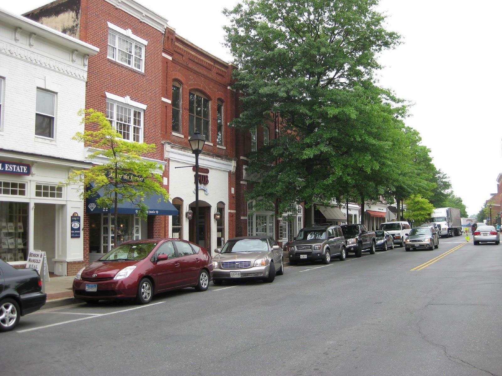
ThoughtheroleofarchitecturecannotbeunderstatedinthebroadappealofEaston’sdowntown,it isequallyimportanttorecognizehowthestructureofthetowncorepromotesitscharmandvalue. Easton’solderneighborhoods,especiallythosesurroundingDowntown,aredefinedbyconnected streets,narrowlots,modestsetbacks,frontporches,andarchitecturalvarietyThesewalkable patternssupportinteractionandresilience.Newdevelopmentshouldextendthisstructurethrough compatiblelotdimensions,publicspaceorientation,andhousingdiversity
The2004ComprehensivePlanoutlinedamodelforaTraditionalNeighborhoodDevelopment (TND)District,designedtoencouragethekindsofmixed-use,compactneighborhoodsEaston values.Thatproposalwasultimatelyrejected notduetodisagreementwithitscontent,but becauseitremovedtheTownCouncilandpublichearingfromthereviewprocess.Thiscreated
opposition,despitethefactthatthestandardsthemselvesreflectedthecommunity’svision.At present,creatingthesetypesofneighborhoodsrequiresuseofthePlannedUnitDevelopment (PUD)process,whichdeveloperstendtoavoidduetoitscomplexity,cost,andunpredictability Instead,theeasierpath conventionalsubdivisionandsiteplanreview toooftenyields suburban-stylesprawl Thismismatchhasledtoasystemwheretheeasiestprojectstoapproveare thosethecommunityleastdesires,whilemorethoughtful,desirabledevelopmentfacesthehighest barriers
InthewakeoftheTNDDistrict’sdefeat,someelementswereintegratedintoEaston’sbasezoning andsubdivisionregulations suchasanti-monotonystandardsandgreaterlotdesignflexibility Still,nearlytwodecadeslater,thelimitationsofthecurrentapproachremainapparent.
ThePlanningCommissionnowrecommendsrevisitingthisissueandreintroducingaTNDDistrict oralternative“by-right”optionwithcleardesignstandards Thegoalistoreversetheregulatory imbalance,makingiteasier notharder fordeveloperstobuildthetypesofneighborhoods Eastonwants
Traditional Neighborhood Development Zone
Minimum Lot size: 5,000 sq. ft. single-family detached 3,000 sq. ft. single-family attached
Maximum Lot size: 12,500 sq. ft. single-family detached 7,500 sq. ft. single family attached
Minimum Setback: 5’ (0’ for commercial uses)
Maximum Setback: 15’ (10’ for commercial)
Maximum Block Length: 480’
Density (per net acre):
- 4 0 du/ac Maximum – 12 du/ac
All subdivisions shall include a variety of housing types, open space, civic space, office or industrial, and neighborhood commercial space in accordance with the following schedule At least 3 of the 5 land uses shall be provided at the ratio specified:
Land Use Ratio
Residential - Middle Housing A minimum of 10% of the units proposed
Common Open Space 35% including a minimum of 1200 sq ft per dwelling unit for parks
Neighborhood Commercial
26 square feet gfa per dwelling unit (See Table 9 in Land Use Chapter for characteristics of Neighborhood Commercial)
52 square feet gfa per dwelling unit
Subdivisions prepared in accordance with these standards shall be processed per the Town of Easton Subdivision Regulations
Subdivisions with single-family detached residential plus only two of the land use elements at the ratio outlined above (or with three or more of the land uses but at less than the prescribed ratio) may be approved by the Easton Town Council via the PUD process.
Subdivisions with single-family detached residential and only one or none of the additional land use elements shall be prohibited
Renderings or conceptual architectural elevations shall be provided for each building type in the neighborhood and shall be subject to approval by the Planning Commission. Neighborhoods should reflect architectural diversity. For all intents and purposes, they should appear as if multiple builders constructed them, whether or not this is in fact the case.
A minimum of 75% of the lots shall have access via an alley Garages on lots with alleys shall be detached or rear/side-accessed attached Lots without alleys shall minimize the impact of garages by locating them behind the front plane of the house, or if in front of the house, accessed from the side
ThepotentialnewTNDZoningDistrictdescribedaboveisprimarilyenvisionedasapplicableforthebuild-outof ourFutureGrowthArea However,asignificantfocusofthisPlanisondirectinggrowthforthenexttenyearsto existing neighborhoodsintheformofInfillDevelopment,Redevelopment,andAdaptiveReuse. Developmentof thisnaturewilllikelyrequireanapproachotherthanTND.
Onepossiblesuchalternateregulatoryapproachthatreceivedpublicsupportthroughoutthepublicreviewand commentprocess,was thatofForm-BasedCodes(FBCs) FBCsarearegulatoryapproachthatitsadvocates suggestareapowerfultooltoeffectchangestothewayinwhichcommunitiesarebuilt Theystandincontrastto traditionalorEuclideanZoninginthattheyemphasizethedesign/formofbuildingsandtheirrelationshiptothe publicrealmmuchmoresothantheuseoftheproperty. Thebook Form-Based Codes describesthemas“A methodofregulatingdevelopmenttoachieveaspecificurbanform. Form-BasedCodescreateapredictable publicrealmprimarilybycontrollingphysicalform,withalesserfocusonlanduse,throughcityorcounty regulation”
WhateveroptiontheTownultimatelypursuestoimplementinthisPlanfollowingitsadoption,onethingisclear: anewapproachtolanddevelopmentregulationwillbenecessarytocreatethefutureEastonthatthisPlan envisions. SuchanewCode(s)shouldaddressthefollowingobjectives:
● Permittingavarietyofhousingtypesandappropriatedensitiestoimprovemissingmiddleoptionsand housingaffordability
● Harmoniouslyblendmulti-familyandmiddlehousingwithinresidentialandcommercialblocks
● Softentheimpact oflarge-scaleretailincommercialcorridorsthroughbetterdesignand pedestrian-orientedplacement
● Ensurebuildingscale,massing,andplacementcreateawalkable,invitingstreetscape
● Designstreetsandsidewalksassafe,functionalspacesforallusers-bicyclists,pedestrians,vehicles, andtransit.
● Promotedevelopmentpatternsthatareenvironmentallyresilientandfiscallysustainable.
InordertobestfacilitatethefutureEastonthatthisPlandescribes,theTowncommitstostudyingFBCsandany otheralternativeregulatoryframeworkswithintwoyearsoftheadoptionofthisPlanbytheTownCouncil
Eastonhasalongandcomplexhistorywithmajorretaildevelopment.In2000,theTownimposeda temporarymoratoriumafterreceivingapplicationsforover766,000squarefeetofproposedmajor retailspace.Thispauseledtoamendmentstothe1997ComprehensivePlanandsignificantchanges totheZoningOrdinance TheOrdinancedefined“MajorRetail”asanysingle-useretail establishmentwith25,000squarefeetormoreofgrossfloorarea,andcreatedanewPlannedMajor Retailfloatingzonetoregulatesuchuses Projectsover65,000squarefeetwereprohibited Stringentdesignstandardswerealsoaddedformajorretailandshoppingcenters.
The65,000-square-footcapwasacompromise Someresidentsandstakeholdersargueditwastoo restrictive,whileothersbelieveditwastoopermissive.Atthetime,theGiantgrocerystoreandthe originalLowe’s(nowKohl’s)wereroughlythissize,helpingtodefinethethreshold.
Theroleoflarge-scaleretailcontinuedtogeneratedebatethroughthe2004and2010 ComprehensivePlans.Publicinputcollectedduringtheseupdatesrevealedaconsistentpreference forlimitingmajorretailinEaston Ina2000–2001survey,nearlyhalfofrespondentssaidsuchuses should“never”beadded.In2010,morethanathirdfelttheTownalreadyhadtoomanyshopping centers,andover65%supportedholdingfirmondesignstandards,evenifitmeantlosinga preferredretailer.
Basedonthissustainedfeedback,the2004Planremovedthehardcaponsquarefootagebut maintainedaregulatorythresholdat25,000squarefeet,requiringalllargerprojectstoundergo case-by-casereviewthroughthePlannedMajorRetailprocess.Theintentwastoretainflexibility whileemphasizingdesign,compatibility,andthebroaderlandusecontext
The2026Plan2025Planagainsolicitedpublicinput,andresponseswerelargelyconsistentwith previoussurveys AstrongmajoritysaidEastonhas“abouttherightamount”ofregional-scale retail,withtwiceasmanyrespondentssayingthereistoomuchratherthantoolittle.Support remainshighforprioritizingDowntownEastonoverothercommercialareas,andformaintaining highdesignstandards.
Giventhesefindings,theTownrecommendsnomajorchangestotheTown’sretailpolicies Major retailuseswillcontinuetoplayalimitedrole,andneworexpandedprojectswillonlybe encouragedunderspecificconditions:
• Priorityshouldbegiventoredevelopmentorredesignofexistingshoppingcenters, especiallywhereprojectsresultinimprovedsitedesign,circulation,orconversionto mixed-use
• RegionalretailshouldserveprimarilyTalbotCounty,andsecondarilynearbyareasin Caroline,Dorchester,andQueenAnne’sCounties Eastondoesnotaimtobecomearegional shoppinghubforawiderarea.
• Applicantsproposingrelocationorreplacementofanexistingmajorretailstoremust submitadetailedreuseplanforthevacatedsite.
Easton’sapproachtomajorretailhasconsistentlyreflectedcommunityvalues:adesirefordesign quality,modestscale,andeconomicalignmentwiththeTown’sroleasalocal,notregional,retail center.
VisitorsarrivinginEastonformimpressionsoftheTownbasedonitsmajorcorridors.These includeUS Route50,MD322,WashingtonStreet,andPortStreet Thedesignandappearanceof theseareas buildings,signage,landscaping,andpublicinfrastructure playacentralrolein shapingEaston’sidentity
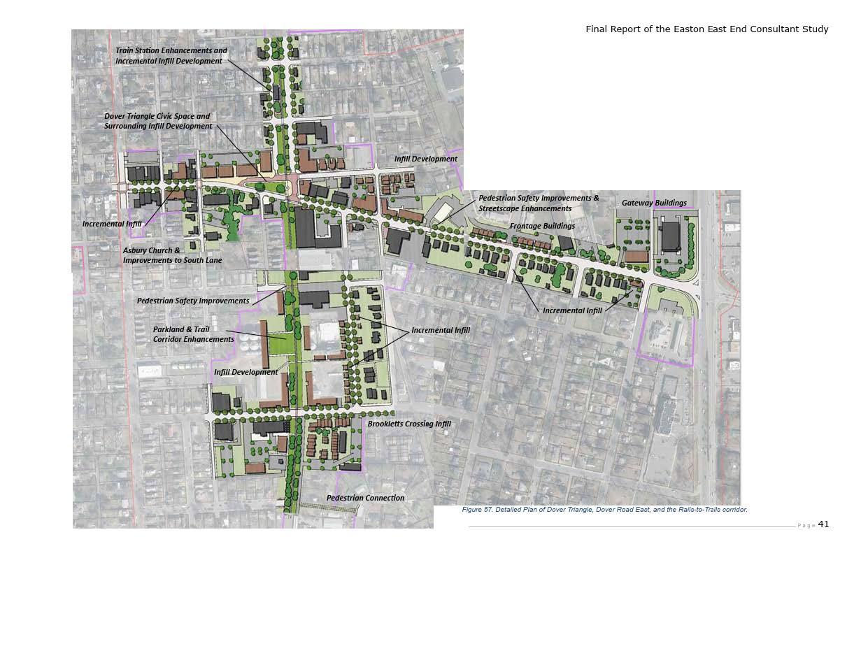
Significantimprovementshavebeenmadetosomecorridorsthroughsiteplannegotiationand designreview.revisedlayouts,upgradedmaterials,andimprovedorientation.However,manyareas stillrequirereinvestment ThenewARCoftheChesapeakeandDoverbrookApartments,for example,exhibitexemplaryadditionstotwomajortowncorridors. Goingforward,theTownwill adoptcorridor-specificstandardsandexploreoverlayzonestoguideincrementalupgrades Figure 1belowiscopiedfromtheDraftEastEndSmallAreaPlananddepictshowaportionofDoverRoad couldberedevelopedinawaythatisgenerallymoreconsistentwiththeprinciplesofthisPlan,and whichcouldvisually (and,presumably,economically)enhancethismajorcorridor.
Goal #1: Encourage mixed-use, traditional neighborhoods over single-use subdivisions
Objectives:
● ReintroducetheproposedTraditionalNeighborhoodDevelopment(TND)ZoningDistrictas thedefaultzoningforundevelopedandannexedlandinEaston
● Continuereviewingandupdatingthedesignandanti-monotonystandardsfirstadoptedin 2006
● Restructurethedevelopmentreviewprocesstostreamlineapprovalsfortraditional neighborhooddevelopmentswhileincreasingscrutinyanddifficultyforconventional suburbansubdivisions
● Explorethepotentialregulatoryreformsnecessarytoproducethetypeofdevelopment envisionedbythisPlaninconjunctionwiththenextcomprehensivereviewoftheTown’s ZoningCode.
Goal #2: Improve the appearance of existing development
Objectives:
● PartnerwiththeStateHighwayAdministrationtoenhancelandscapingalongstate highways,especiallytheRoute50corridor.
● UsetheForestConservationAccounttoretrofitlandscapinginolderstreetscapeswhere plantingsaresparseormissing.
● Requireanyrenovationorchange-of-useprojectneedingsiteplanapproval,aPUD amendment,specialexception,orvariancetofullycomplywithcurrentdesign standards nograndfatheringofoutdateddesigns.
● RequirenewlandscapingorimprovementsalongU.S.Route50foralladjacentnew developmentorredevelopment.
● Enforcerequirementsforlandscapingandmaintenanceassociatedwithapproved developmentprojects.
● RefineandworkwithDesignStandardsthatensurethatEastonstandsoutasauniqueplace ratherthanlookinglike“AnyplaceUSA.”
Goal #3: Raise the design quality of all new development
Objectives:
● FullyapplyEaston’srecommendedDesignPrinciplestoallnewdevelopment
● Prohibitnewconstructionthatreliesoncorporatefranchisearchitecture.
● Adoptcomprehensivedesignstandardsforallnewdevelopment,includingresidential projectsandinfill/redevelopment.
● ReviewandupdatetheDesignGuidelinesforNewConstructionoutsidetheHistoricDistrict
● Strengthenlandscapestandards,emphasizingnativespeciesandimprovedscreeningof unattractivesitefeatures.
Goal #4: Promote infill and redevelopment
Objectives:
● EvaluatetheeffectivenessoftheZoningCode’sPlannedRedevelopmentOverlay District includingitsboundaries,standards,andprocess todeterminewhetheritoffers sufficientincentives.
● Identifyandpursuenon-zoning-basedincentives,inpartnershipwithrelevantagencies,to supportinfillandredevelopment.
● PrepareSmallAreaPlansforEastonneighborhoodstotailorredevelopmentstrategiesto localneedsandconditions.
Goal #5: Encourage continued restoration, adaptive rehabilitation and preservation of historic structures, sites, streetscapes, and settings and encourage compatible infill in the Historic District.
Objectives:
● Educate residents/realtors and property owners about the benefits, boundaries and requirements of theHistoricDistrictreviewprocessanddesignstandardsandaboutthe availabilityofstateandfederaltaxcreditsforhistoricpreservationprojects
● EstablishaLocalTaxIncentiveprograminEastonthatencourageshistoricpropertyowners to rehabilitate their property Thislocaltaxincentivewillcomplementexistingstateand federaltaxincentivesthatencouragehistoricrehabilitation/restoration.Some19counties andmunicipalitiesinMarylandalreadyhavesomeformoflocaltaxincentive.
● Encourage a“RebuildingTogether”chapterinEastonorTalbotCounty.Thisisanational organization whose objective is no cost repairs to homes of low income, over60home owners
● Modify the Historic Commission’sGuidelinesbyaddingspecificguidanceandcriteriafor adaptivereuseprojects.
Goal #6: Continue to support the Easton Historic District.
Objectives:
● Ensure consistent enforcement of Easton’s Historic District by utilizing the services of variousstaffswithinthetownadministration. Aconsistentlyenforcedhistoricdistrictisthe mosteffectivehistoricdistrictforfosteringinvestmentandeconomicdevelopment.
● Providein-servicetrainingforthestaffandHistoricDistrictCommission members.
● InvestigateCertifiedLocalGovernmentstatuswiththeMarylandHistoricalTrusttoprovide eligibilityforgrantsforcontinuingeducationforstaffandmembersoftheHistoricDistrict Commission,aswellasotherprojects.
● InvestigateaprojecttoresurveytheHistoricDistrict.Anewsurveywillupdateinformation containedintheoriginalNationalRegisternominationandfacilitateenhancedprocessingof applications SuchasurveycouldalsoleadtoanewnominationtoexpandtheNational RegisterDistrict,includingneighborhoodsthatdidnotmeetthecriteriaforlistingin1980, butnowmaynearlythreedecadeslater Suchaprojectcouldbesupportedbygrantfunding andcouldpotentiallybedoneundertheauspicesofapartnerorganization.
THE ULTIMATE RESOURCE IN ECONOMIC DEVELOPMENT IS PEOPLE. IT IS PEOPLE, NOT CAPITAL OR RAW MATERIALS THAT DEVELOP AN ECONOMY.
PETER DRUCKER
A. PURPOSE
Economicandcommunitydevelopmentarevitaltothehealthofatownbecausetheyfoster sustainablegrowth,improvequalityoflife,andstrengthenitspositionasadesirableplacetolive andvisit.
ThenonprofitEastonEconomicDevelopmentCorporation(EastonEDC)provideseconomicand communitydevelopmentservicestotheTownofEaston. TheEastonEDCalsomanagestheMain StreetDistrictandArts&EntertainmentDistricts,aswellastheEastonVisitorCenter. ABoardof Directorshasbeenestablished,withrepresentativesfromthecommunity,theMayoroftheTownof EastonandonedesignatedCouncilmember.
In2025,theEastonEDCadoptedaforward-lookingStrategicPlanthatidentifiesfourkeyStrategic Prioritiesaimedatfosteringsustainablegrowth,improvingqualityoflife,andstrengthening Easton’spositionasapremierdestinationonMaryland’sEasternShore.ThisComprehensivePlanis alignedwiththoseprioritiesandincorporatesthemintoEaston’slong-termdevelopment framework
Inaddition,thisPlanrecognizesthatEaston’seconomicdevelopmentstrategymustreflectregional collaboration Therefore,itintegratestheprioritiesandinitiativesofboththeTalbotCounty DepartmentofEconomicDevelopmentandTourismandtheMid-ShoreRegionalCouncil.This collaborativeapproachensuresthatlocaleffortsaresupportedbybroaderregionalinitiativesand thatresourcesarecoordinatedformaximumimpact.
AsinmanyComprehensivePlans,economicdevelopmentanalysisoftendependsheavilyon quantitativedatasuchastablesandcharts.WhilethisPlanminimizestheoveruseofsuchtools, essentialinsightsaredrawnfromCensusdata(seeTables5and6) Keyfindingsinclude:
● IncomelevelsinEastonarebelowthoseofTalbotCountyandtheStateofMaryland,witha correspondinghigherrateofpoverty
● EducationalattainmentinEastonlagsbehindboththecountyandstate,especiallyinthe percentageofresidentswithbachelor’sdegreesorhigher.
● Eastonhasanagingpopulation,withasignificantlyhigherpercentageofresidentsaged65and oldercomparedtostateaverages.
● CommutetimesinEastonareslightlyshorterthanregionalandstateaverages,reflectinglocal employmentopportunities
● ThehomeownershiprateinEastonislowerthanTalbotCountyandtheState,whichmayreflect affordabilitychallengesorhousingstocklimitations.
Table 5 - Select Economic Characteristics
Source: 2020 Census, U S Census Bureau
CAPITA INCOME (2022 dollars)
IN CIVILIAN LABOR FORCE, TOTAL, PERCENT OF POPULATION AGE 16+, 2018-2022
IN CIVILIAN LABOR FORCE, FEMALE, PERCENT OF POPULATION AGE 16+, 2018-2022
MEAN TRAVEL TIME TO WORK (MINUTES), WORKERS AGE 16+, 2018-2022
HIGH SCHOOL GRADUATE OR HIGHER, PERCENT OF PERSONS AGE 25+, 2018-2022
BACHELOR’S DEGREE OR HIGHER, PERCENT OF PERSONS AGE 25+, 2018-2022
EMPLOYER
REFERENCE YEAR 2022
Table6belowprovidesabroadercomparisonofEaston,TalbotCounty,andtheStateofMarylandin anumberofeconomicandnon-economiccharacteristics.
Table 6 - Comparison of Easton, Talbot County and State of Maryland in Selected Demographic Characteristics from the 2020 Census (and 2023 ACS)
Subject
Households
Housing Units Not Reported
AdiverseandresilientbusinessmixisessentialtothesustainabilityofEaston’seconomy. OverdependenceonasinglesectorcanexposetheTowntoeconomicfluctuationsandjoblosses. Easton’sstrategyemphasizesresiliencebyinvestinginworkforcedevelopment,nurturing entrepreneurship,andsupportingbothlegacybusinessesandemergingindustries
TheEastonEDCStrategicPlan(FY2026–2028)underscorestheimportanceofbusinessretention, expansion,andrecruitment particularlyforhigh-wageindustries
Initiativesinclude:
● Facilitatingleadershipforumsandindustryroundtablestoidentifyinfrastructureneeds, workforcetrends,andbusinesschallenges.
● DevelopinganEastonBusinessRecruitmentPacketthathighlightsincentives,infrastructure, realestateopportunities,andthebenefitsofEaston’slocationandcommunitycharacter
● MarketingkeysiteslikeMistletoeHallandotherstrategiclocationsfordevelopment,ensuring readinessfornewinvestment.
● PartneringwiththeTownofEaston,TalbotCounty,andlocalinstitutionstocoordinate incentivesandimplementjointmarketingcampaigns
● Promotinginfilldevelopmentandredevelopment particularlyprojectsthatsupportaffordable workforcehousinginproximitytojobcenters.
● Diversifyingfundingstreamsbypursuingfederal,state,andphilanthropicgrantsaswellas privatesponsorshipsandinnovativefundingmodels
TourismremainsacornerstoneofEaston’seconomy contributingnotonlythroughvisitor spendingbutalsobyenhancingtheTown’svisibilityandqualityoflife Asayear-rounddestination withathrivingculturalandculinaryscene,Eastonhastheopportunitytofurtherdevelopits tourismsectorinstrategicandsustainableways.
TheEastonEDChasidentifiedseveralprioritiestostrengthenEaston’sbrandastheEasternShore’s premierdestination:
● Createadata-informedtourismmarketingstrategythattargetsregionalandnationalaudiences, tailoredtoEaston’suniqueofferings.
● EnhancethevisualappealandaccessibilityofDowntownEastonwithimprovedsignage, plantings,banners,andpublicart.
● ActivatetheEastonVisitorCenterasaneducationalandexperientialhubfortouristsand residentsalike
● Collaboratewithsurroundingjurisdictions(e.g.,St.Michaels,Oxford,TalbotCounty)tolaunch jointtourismcampaignsandsharedeventcalendars
● SupportauthenticlocalexperiencesandsignatureeventsthathighlightEaston’shistory,arts, foodculture,andcommunityspirit.
Eastonisatapointwhereanumberofourshoppingcentersareforonereasonoranother,viewed asprimecandidatesforredevelopment. Suchreasonsincludeageofthecenter,maintenance challenges,tenantmix,oroverallutilityofthecenter. Potentialredevelopmentcouldbeassimple asfacadeupgrades,newcolorschemes,updatedsignage,etc,tocompletedemolitionand reconstruction. ThisredevelopmentcouldbringEastonnumerouseconomicbenefitsincludingnew businessestablishments,additionaljobs,andadditionalrevenue Furthermore,itcouldaddfuture opportunitiesformixeduseresidentialofferingsaswellasbeautifymanyoldersitesaroundtown Potentialcandidatesforsuchupgradesinclude:
● EastonPlaza(siteofBowlingAlleyandAmishFarmer’sMarket) Withabundantparking locatedbetweenMarlboroAvenueandthebuildingsinthisshoppingcenter,therearea varietyofoptionstoaddorrelocatebuildingsclosertoMarlboro Thiswoulddramatically improvethestreetscapeandmovefromanoldersuburbanshoppingcenterformof developmenttowardsamoretraditionalTown-centerpattern,whichcouldalsoshiftthe perceptionofMarlborofromaseparateanddistinctshoppingcorridortomoreofan extensionofDowntown.
● ChesapeakeVillage(siteofRuby’sCakeShopandDomino’sPizza) Thissmallneighborhood shoppingcenterislocateduniquelywhereDoverRoadandDoverStreetseparateandform thetriangularparkadjacenttotheRailTrail,whereEaston’scommunityChristmasTree resides. TheEastEndSmallAreaPlanthatisbeingdevelopedconcurrentlywiththis ComprehensivePlandevotesafairamountofattentiontothisparkandenvisionsan upgradeand/orexpansionofit Apotentialredevelopmentoftheshoppingcentercould enhancetheutilityofboththecenterandthepark,tothebenefitofeachaswellastothe EastEndneighborhoodandDoverRoadcorridor
● EastonMarketplace(siteofKohl’sandLowe’s). Althougharelativelynewshoppingcenter, therecentclosingoftheRubyTuesday’srestaurant,theexistenceofaremainingpadsite(to theeastofAspenDental)andtheabundanceofparking(particularlybetweenKohl’sand
Marlboro)therewouldseemtobeampleopportunitiestoaddnewtenantstothiscenter throughacombinationofadaptivereuseofbuildingsandnewconstruction.
Asuccessfuleconomicdevelopmentstrategymustalsobuildcommunitywealthandpride.The EastonEDCStrategicPlanrecognizesthatbroadresidentengagementandcivicparticipationare essentialtolong-termprosperity Prioritiesincommunitydevelopmentinclude:
● Expandoutreachandtransparencythroughnewsletters,publicpresentations,anddirect engagementwithneighborhoodgroups,clubs,andschools.
● Launchaformalvolunteerprogramwithtraining,leadershipopportunities,andrecognition effortstobuildlocalownershipandcapacity.
● HostacalendarofinclusiveeventsthatreflectEaston’sculturalrichnessandfostercommunity connectedness.
● Evaluatecivicengagementandqualityoflifethroughperiodicsurveys,helpingtoalignfuture investmentswithpublicneedsandvalues
GOAL #1: Nurture a healthy and diverse local economy in Easton.
Objectives:
● Conductleadershipforumsandfocusgroupswithlocalindustriestoguideeconomic strategies
● MarketandsupportstrategicsiteslikeMistletoeHall
● Developacomprehensivebusinessattractionandretentionstrategyincoordinationwith EastonEDC
● Prioritizeredevelopmentprojectsthatsupportworkforcehousing
● Expandgrantwritingcapacityandpartnershipstofundeconomicinitiatives
GOAL#2: Maintain and recreate a vital Downtown.
Objectives:
● Increaseawareness,usageandvalueoftheEastonVisitorCenter
● Improvevisitorwayfinding,visualappeal,andaccesstodowntownattractionscoordinating withEastonEDCtomarketdowntowneventsandtourismopportunities
GOAL #3: Engage the community in Easton’s economic future.
Objectives:
● Seekcommunityinputviacommunitycharrettes
● Communityoutreachandcommunicationviain-personpresentations,andprintand electronicmedia
● Launchatown-widevolunteerprogram
● Useplacemakingsurveystoassesscivicengagementandguidefuturepriorities
Providingsafe,decent,andsanitaryhousingforallresidentsisessential Whenacommunity neglectsthis,housingconditionsdeteriorate,businessesmayclose,andtheoverallappearanceof communitiescanfuelagrowingsenseofdespair.Eastonoffersawiderangeofhousingtypes,from colonialeratonineteenth-centuryhomesnearDowntowntopublichousingsuchasGraham’sPlace andtherecentlyrebuiltDoverbrookapartments,aswellassubdivisionssuchasCooke’sHope, EastonVillage,HuntersMillandMulberryStation Today,evenmorethanhousingquality,the rapidlyrisingcostofhousinghasbecomeahotbuttonissueforbothresidents,employersand commuters
HousingfirstbecameanelementofEaston'sComprehensivePlanin2004.Itisnowamandatory elementofMarylandcomprehensiveplansratherthananoptionalelement Manyoftheissues, otherthanrapidlyrisinghousingcosts,associatedwiththisElementremainessentiallythesame todayin2025astheywerein2004.
Statelawnowspecifieswhatthiselementmustaddress:
(a)
(1) In this section the following words have the meanings indicated.
(2) "Affirmatively further fair housing" has the meaning stated in § 2-401 of the Housing and Community Development Article.
(3) "Area median income" has the meaning stated in § 4-1801 of the Housing and Community Development Article
(4) "Low-income housing" means housing that is affordable for a household with an aggregate annual income that is below 60% of the area median income
(5) "Workforce housing" has the meaning stated in § 4-1801 of the Housing and Community Development Article
(b) A housing element may include goals, objectives, policies, plans, and standards.
(c) A housing element shall address the need for affordable housing within the local jurisdiction, including:
(1) workforce housing; and (2) low-income housing. (d)
(1) Local jurisdictions have a duty to affirmatively further fair housing through their housing and urban development programs
(2) The housing element of a comprehensive plan that is enacted or amended on or after January 1, 2023, shall include an assessment of fair housing to ensure that the local jurisdiction is affirmatively furthering fair housing.
(3) On request of a local jurisdiction, the Department of Planning, in consultation with the Department of Housing and Community Development, shall provide technical assistance for the purpose of developing the housing element of the comprehensive plan.
(4) This subsection does not require a local jurisdiction to take, or prohibit a local jurisdiction from taking, a specific action to affirmatively further fair housing.
(Md Code, LU § 3-114)
B
Eastonhasmanyhousingissues,buttheycanallbegenerallycategorizedasoneofthreeproblems: housingcost,housingquality,andhousingavailability.Tosomeextenttheseproblemsare interrelated
HousingaffordabilityhasbecomesosignificantanissuethattheTownformedanadhocAttainable HousingTaskForcetoexaminetheproblemandmakerecommendationstoaddressit TheTask ForceworkedontheissuesduringthisCompPlanupdateprocessandproducedadraftreportin Mayof2024.TheFullFinalReportcanbeaccessedontheTown’swebsiteat: eastonmdgov/xxxxxxxxx TheFinalReportwaspresentedtotheTownCouncilattwoWorkshops inNovemberandDecemberof2025.AsofthedateofthisPlan,theCouncilwasstilldeliberatingthe appropriatecourseofactionforaddressingthevariousrecommendationsoftheReportTheDraft Report’sExecutiveSummaryincludesthefollowing:
The Housing Task Force Final Report provides an analysis of Easton’s housing landscape, demographic shifts, economic trends, and affordability challenges. The report also expands on the demographic, market, and workforce overview briefly provided to the Task Force at their May 23, 2024 meeting. Any data-driven insights provided herein are intended to inform housing policies and initiatives recommended by the Attainable Housing Task Force aimed at ensuring equitable and sustainable housing opportunities.
1. Population Growth & Demographics
• Easton experienced rapid population growth between 1980 and 2010, but growth rates have slowed significantly since 2010.
• The town's population is aging, with a 42% increase in residents aged 55+ since 2000, while the percentage of younger adults (25-44) has declined by 40%.
• The Hispanic population has grown significantly, increasing from 3 5% of the total population in 2000 to 14% in 2020, while the Black population’s share has declined.
• Since 2000, single-family detached homes have dominated new housing developments, limiting the availability of more affordable housing types such as townhomes and multi-family units.
• Home prices have risen sharply, with Easton’s median home value increasing by 131% since 2000
• Rental costs have also increased, with median rents in 2025 exceeding the affordability threshold for households earning less than 100% of Easton’s Area Median Income (AMI).
• Homeownership is increasingly out of reach for middle-income families, with the home price-to-income ratio rising from 3 03 in 2000 to 4 4 in 2024, indicating a decline in affordability.
• Over 50% of renters in Easton are cost-burdened, spending more than 30% of their income on housing.
• Racial disparities persist, with Hispanic and Black households facing the greatest housing cost burdens and lowest homeownership rates.
• Job growth in Talbot County has remained stagnant since 2000, increasing at an annual rate of just 0 18%
• The local economy has shifted toward lower-paying service jobs, making it harder for workers to afford housing in Easton
• A significant portion (42%) of the workforce commutes from neighboring counties, highlighting the disconnect between housing costs and local wages
Easton faces significant housing challenges, particularly in affordability, supply diversity, and demographic shifts Without strategic interventions, rising housing costs and demographic imbalances could threaten the town’s long-term economic sustainability and community inclusivity This report serves as a foundation for developing policies that ensure a balanced, affordable, and thriving housing market for all residents.
Eastonrisksbecomingaplacewherethosewhoworkherecannolongeraffordtolive This challengewillonlygrowiftheTown’stourismandhospitalitysectorsexpandasexpected.Alackof affordablehousingalreadyaffectsessentialworkers cashiers,restaurantstaff,government employees,teachers,nurses,emergencyresponders,eldercareaides whoincreasinglyfind Eastonoutofreach.
ThishasbroadimplicationsforEaston’sfuture Economicallysegregatedcommunitiesweaken socialandculturalcohesion.Theyalsoburdenthetransportationsystem.Asworkersseekhousing inneighboringcountieslikeDorchesterandCaroline,theybecomecommuters,addingtotraffic congestion.TheTownalsofaceseconomicandworkforcerisksiftheseworkerseventuallytakejobs closertohome.
Eastonhaslongrecognizedtheimportanceofhousingquality.TheTownenforcestheInternational BuildingCodeandstaffsaBuildingDepartmentthatincludesaBuildingOfficial(whoconductsplan reviews),twofieldinspectors,arentalhousing/propertymaintenanceinspector,andasecretary
Tomaintainlivabilityinrentalhousing especiallyolderunits EastonlauncheditsRentalHousing InspectionProgramin1995.Theprogramrequireslandlordstoobtainlicensesandsubmitto regularinspections Itwascomprehensivelyreviewedandupdatedin2008tostrengthenits effectiveness.
InEaston,housingisprimarilyprovidedbytheprivatesector.However,afewpublicandnonprofit programsofferlimitedaffordablehousing,includingeffortsbytheHousingCommissionofTalbot County,subsidizedprivatedevelopmentslikeChathamVillageApartments,andhomesbuiltby HabitatforHumanityofChoptank,Inc
TheHousingCommissionofTalbot (FormerlytheEastonHousingAuthority) recentlyconverted theirportfoliofrompublichousingtoavoucherbasedprogram.Asaresult,theydonotownany morepublichousing Instead,theyhaveaninventoryof79voucherbasedunitsinEaston They administer159HousingChoiceVouchers.Theyalsohave9unitsofnet-zerohousingonPortStreet (NicholasLanding),12unitsofaffordablehousingonPleasantAlleyand4duplexunitsonPort Street.
HabitatforHumanityofChoptank,Inc hasbuiltmorethan25homesinEastonusingits volunteer-drivenmodel.Futurehomeownerscontributesubstantial"sweatequity"during constructionandlaterassistotherHabitatfamilies Withdonatedordiscountedlandandnolabor costs,overallhousingcostsarekeptlow.And,theTownCouncilhasexpandedaffordablehousingby requiringdevelopersofdiscretionaryprojects likeannexationsorPUDs toincludeon-oroff-site affordableunitsorcontributetotheTown’sAffordableHousingfundasaconditionofapproval AkeystepinaddressinghousingissueswasthecreationoftheEastonAffordableHousingBoardin 2005 AppointedbytheTown,theBoarddevelopspoliciesandcriteriaforaffordablehousingand overseesunitsacquiredbytheTownthroughdevelopmentapprovals.Earlyeffortsfocusedon establishingguidelinesandaselectionprocessforpurchasingtheseunits AmorerecentProgram thathasproventobesuccessfulistheBoard’sRenovationProgram. Throughthisprogram, homeownersmayapplyforagrant,nointerestdeferredloanorlowinterestloandependingon theirincome,forapprovedrenovationstoimprovetheenergyefficiency,safety,andlivabilityof theirhome. Thishelpshomeownerswiththesecosts,whichinturnhelplowermonthlyutilitybills, andallowsthemtoremainintheirhomeslonger
ThefullAttainableHousingTaskForceReportcontainsdetailedinformationonlocalandregional housingcostsandaffordabilitydata. Highlightsarepresentedinsectionswhichfollow
The Zillow Home Value Index (ZHVI) for Talbot County reflectsthegeneraldirectionof homevaluesinourcommunity sincetheyear2000Nationally, homepricespeakedin September2006,thenbeganto declinelaterthatyearandinto 2007.By2008,thehousing markethadcollapsed, triggeringabroaderfinancialcrisisknownastheGreatRecession(2007–2009).Themarkethit bottomin2012,followedbyaslowrecoverythrough2016
TalbotCountyfollowedasimilartrend.Asshownabove,theZillowHomeValueIndex(ZHVI) peakedat$420,000inSeptember2006,thenfell21%by2009 Itbottomedoutat$280,000in September2012.Fromthere,valuessteadilyrose,reaching$334,000bytheendof2019 a19% increase.Between2015and2019,theZHVIgrewatanaverageannualrateof2.4%.Beginningin 2020,homevaluessurged43%,reaching$478,000bytheendof2024 anaverageyearlyincrease ofabout9%. ItisimportanttonotethatwhiletheZHVIoffersahelpfulsnapshotofhousingtrends inTalbotCounty,itisnotareplacementforprofessionalappraisals
ThisreportanalyzedmedianhomesalepricesinTalbotCountyfor2000,2010,2020,and2024 gBrightMLSdatafromthe Mid-ShoreBoardofRealtors. Figure34comparesthese valueswiththeZHVI,showing bothfollowedsimilartrends
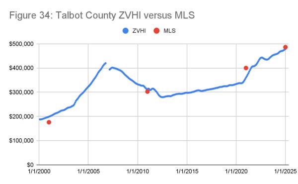
overtime.Percentagedifferencesbetweenthetwosources,rangingfrom13%in2000tojust2%in 2024,withanaveragegapof7%.BothZHVIandMLSofferreliableinsightsintolong-termhousing trends
Insummary,thehighcostofsingle-familydetachedhomesinEastonposessignificantaffordability challenges particularlyforfirst-timebuyersandworkersinlower-wageprofessionswithlimited incomegrowthpotential.
In2024,TalbotCounty’sAnnualMedianIncome(AMI)was$106,500 TheEastonAffordable HousingBoardadjuststhisfigureannuallytobetterreflectlocalincomes;in2020,Easton’sAMIwas $98,065 Giventhesmallgapbetweenthetwo,TalbotCounty’shomeprice-to-incomeratioserves asausefulaffordabilitymetricforEaston.BasedonMSBRdata,the2024ratiowas4.4,meaningit takes4.4yearsofmedianincometopurchaseamedian-pricedhome.Thismarksasharpdeclinein affordabilityfrom2000,whentheratiowas303 EvenaftertheGreatRecession,theratioclimbed to4.12,showingacontinuedtrendtowardlessaffordablehousing.
Anotherkeymeasureofaffordabilityis howincomegrowthcomparestorising homepricesovertime InTalbotCounty between2000and2010,homeprices grewmuchfasterthanincomes,leading toasharpdeclineinaffordability,likely drivenbythehousingboombeforethe GreatRecession From2010to2020, growthslowed,andincomeslightly outpacedhomeprices,reflecting post-recessionrecoveryandacoolerhousingmarket.However,from2000to2024overall,home pricesonceagainoutpacedincomegrowth,signalingarenewedaffordabilitygapsimilartothe early2000s
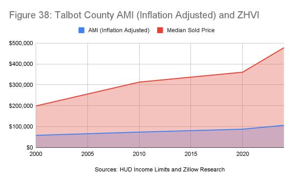
InEaston,40%ofhouseholdsarerenters,afive-pointdropsince2010.Thecurrentrentalvacancy rateis53%,significantlyhigherthanthe14%homeownervacancyrate In2010,thoserateswere 4.8%and5.2%,respectively. The
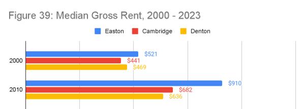
sharpdeclineinhomeownervacanciesreflectsatighthousingmarket,likelydrivenbystrong demandforhigher-endhomesandalimitedsupplyofaffordable,diverseoptions.Demographic shiftsmayalsoplayarole:olderadults morelikelytoownhomes arestayinginplace,while youngeradultsfacegrowingbarrierstohomeownership,contributingtoreducedturnoverand tightersupply
Therentalvacancyrate,at5.3%,fallswithinthehealthyrangeof5–7%,suggestingabalanced rentalmarketwithmoreunitavailabilitycomparedtothemuchtighterfor-salehousingmarket
Therecentuptickinplannedmulti-familyresidentialdevelopmentmayhelpcounterrisingpricesin boththeownershipandrentalmarkets Contributingfactorsincludeslowerhousingabsorption since2010,atightownershipmarket,andashifttowardhigher-pricedinventory.Multi-familyunits offermoreaffordablealternativesforhouseholdspricedoutofhomeownershipandexpandthe rentalsupply helpingtostabilizeorevenreducerentsandimproveaffordabilityforrenters
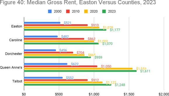
Since2000,Easton’smediangrossrenthasconsistentlyexceededthoseofnearbyDentonand Cambridge,reflectingitsstatusasamorepremiumrentalmarket Themostsignificantincrease occurredbetween2000and2010,when medianrentsroseby74% Duringthat time,92%ofnewhousingconstruction wassingle-familydetachedorattached units limitingrentalsupplyamid growingdemand.Althoughthesharpest risehappenedinthatdecade,rentshave continuedtoclimbsteadilythrough 2023
Comparedtosurroundingcounties,Easton’smedianrentis94%ofTalbotCounty’sbutonly73%of QueenAnne’s Whenrentsarebrokendown bypricerange,there'saclearshortageof unitsaffordabletoextremelylow-income households thoseearningunder$25,000 annually.Thisgapparticularlyaffects individualsatriskofhomelessnessorin needoftransitionalhousing.However,there isarelativelystrongsupplyofunitsinthe
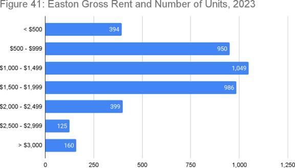
$500–$999range,whichremainaffordableforhouseholdsearninguptoabout$45,000peryear.
Cost-burdenedhouseholdsarethosespendingmore than30%oftheirgrossincomeonhousing.This strainoftenforcesfamiliestochoosebetween housingandessentialslikefood,healthcare, transportation,orsavings underminingtheir overallwell-being.
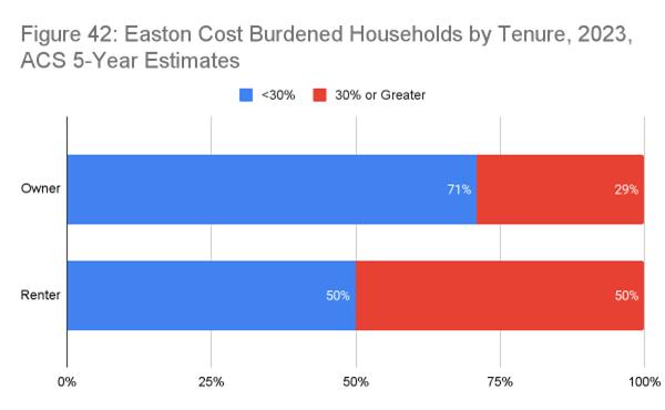
Accordingto2023ACSdata,halfofEastonhomeownerswithamortgagepay$2,000ormoreper monthinhousingcosts.Yetonly29%areconsideredcost-burdened spendingover30%oftheir incomeonhousing.Thisindicatesarelativelyhighincomelevelorgreateraffordabilitytolerance amonghomeownersinEaston
ThisalsohighlightsthathousingcostsinEastonarerelativelyhigh,evenformiddle-income households At80%ofEaston’s2024AMI($98,065),ahouseholdshouldspendnomorethan $1,961permonthonhousingtostaybelowthecost-burdenedthreshold.Manyhomeownersexceed thisamountyetstillfalljustunderthe30%limit,indicatingthatevenmiddle-incomefamiliesare feelingpressure.Infact,ACSdatashowsthat62%ofowner-occupiedhouseholdsearningunder $75,000arecost-burdened,comparedtojust9%ofthoseearning$75,000ormore underscoring thegrowingaffordabilitygap.
Whilemiddle-incomehomeownersfacegrowingpressureinEaston’shousingmarket,thesituation isevenmoresevereforrenters particularlythosewithlowerincomes In2023,50%ofrenters werecost-burdened,comparedto29%ofhomeowners.Thissharpdisparityunderscoresthe greateraffordabilitychallengesrentersfacebyspendingadisproportionateshareoftheirincome onhousing.Theresultisincreasedfinancialinstability,housinginsecurity,andstrainonoverall well-being
AccordingtoHUD’sFY2024IncomeLimitsSummary,TalbotCounty’sMedianFamilyIncome(MFI) forafamilyoffouris$106,500 11%abovetheaverageforMaryland’sEasternShore(excluding CecilCounty)andthethirdhighestintheregion,followingQueenAnne’sandKentcounties.
TalbotCounty’sMFIhasgrownsteadilysince1990,reflectinglong-termeconomicprogress The sharpestincreaseoccurredbetween1990and2000,witha65%gain.Overall,from1990to2024, theMFIhasrisenby203% ThecurrentMFIisbasedonthe2018–2022ACS5-yearestimateof $100,321,adjustedforinflationusingCongressionalBudgetOfficeprojectionsandroundedtothe nearest$100.
HUDusesMFItoestablishincomethresholdsbyhouseholdsize,categorizinghouseholdsas ExtremelyLow,VeryLow,orLowIncome.Thesethresholdsdetermineeligibilityforarangeof housingassistanceprograms,includingPublicHousing,Section8vouchersandproject-based assistance,Section202housingforolderadults,andSection811housingforpeoplewith disabilities
InEaston,theAffordableHousingBoardadjuststheCounty’sMFItobetterreflectlocaleconomic conditions ForFY2024,Easton’sadjustedMFIis$98,065 Thisfigureisusedtoseteligibilityand affordabilitystandardsforTownhousingprograms.
BasedonthisadjustedMFI,afour-personhouseholdearning\$98,065peryearcanaffordahome pricedatapproximately$277,000 assuming35%ofgrossincomeisspentonhousingcosts.This estimatefactorsinmortgageprincipalandinterest,propertytaxes,homeownersinsurance,private mortgageinsurance(PMI),andHOAdues,basedona5%downpaymentanda695%30-yearfixed interestrate.Itshouldbenotedthatthisfigurediffersfromthe30%usedbytheTown’saffordable HousingBoard Thatisbecausethiscalculationisbasedonthefollowingdefinition:“Affordable OwnerExpense:Housingcostthatdoesnotexceedone-twelfthof35%of100%oftheEastonArea MedianIncome,adjustedforhouseholdsizetoincludePrincipalandInterest,Taxes,andProperty Insurance(PITI);PrivateMortgageInsurance(PMI);andHomeownerAssociationdues.” The calculationaboveassumes$200monthlyforbothHOAduesandpropertyinsurance,andappliesa propertytaxrateof129%per$100ofassessedvalue,basedona3-yeartrailingaverageZHVIof $419,647.
Incontrast,themedianhomepriceinEastonin2024was$450,000,accordingtoMarketStatsby ShowingTime(Mid-ShoreBoardofRealtors) 38%abovewhatamedian-incomehouseholdcan
afford.Eventheaveragepriceforanattachedhome,suchasatownhome,exceedsaffordabilityby 21%.Ahouseholdwouldneedtoearnapproximately$137,000,or140%ofEaston’sadjustedAMI, toaffordahomepricedat$420,000
Thesefigureshighlightthegrowinggapbetweenincomesandhomeprices andthepressingneed formoreaffordablehousingoptionsinEaston
HUDcalculatesFairMarketRents(FMRs)toestablishpaymentstandardsforrentalassistance programssuchastheHousingChoiceVoucherProgram ForFY2025inTalbotCounty,FMRsare basedonaveragegrossrentsfromthe2018–2022ACS,adjustedforinflationandlocalmarket conditions IfthecalculatedvaluefallsbelowtheMarylandstateminimum,HUDraisesit accordingly.Bedroom-specificratiosarethenappliedtotheadjustedtwo-bedroomrentto determineFMRsforotherunitsizes.ThesefiguresarelistedinTable7below.
Arenterhouseholdisconsideredcost-burdenedifitspendsmorethan30%ofgrossincomeon rent.Forafour-personhouseholdearning60%ofEaston’sadjustedAMI($58,839),affordable rent netofa$100monthlyutilityallowance isapproximately$1,371forathree-bedroomunit.
AsofMarch2025,Zumperreportstheaveragerentforathree-bedroominEastonis$2,400,a10% increaseoverthepreviousyearAbout75%ofrentsfallbetween$1,501and$3,000 Themedian rentforatwo-bedroomis$2,499,andacrossallunittypes,themedianmonthlyrentis $2,549 27%higherthanthenationalaverage Forapartmentsspecifically,theaveragerentis $2,699,withtwo-bedroomapartmentsaveraging$2,044.
AsshowninTable8,afour-personhouseholdearning60%ofEaston’sAMIcannotaffordaone-, two-,orthree-bedroomrentalinEastonwithoutbeingcost-burdened.Toaffordthemedianrentof $2,525,ahouseholdwouldrequireasignificantlyhigherincome
Exclusionaryzoningreferstoland-useregulationsthatlimitthetypesofhousingallowedincertain areas oftenundertheguiseofpreservingneighborhoodcharacterormanaginggrowth Common toolsincludeminimumlotsizes,buildingheightlimits,andrestrictionsonmulti-familyhousing. Whiletheseregulationsmaybewell-intentioned,theireffectisoftentoincreasehousingcostsand limitaccessforlower-incomeindividualsandfamilies
Considerahalf-acrelotzonedforsingle-familyhomeswithminimumlotsizerequirements.A developerpurchasingthislotmighttheoreticallychooseamongthreeoptions:
• Amodest1,200sq.ft.starterhomesuitedforfirst-timebuyersordownsizingretirees;
• Sevenattachedtownhomesthatcouldoffermoreaffordableownershipoptions;or
• Alarge,upscalesingle-familyhomemarketedtoaffluentbuyers.
However,existingzoninglikelyprohibitshigher-densitydevelopment suchas townhomes throughrestrictionsonlotcoverage,density,orallowedhousingtypes.Asaresult,the developer,constrainedbyregulationsandseekingtomaximizeprofit,willalmostcertainlychoose tobuildalargeluxuryhome.Althougheachtownhomewouldyieldasmallerindividualprofit,the combinedrevenuefrommultipleunitswouldexceedthatofasinglehigh-endhome Butzoning doesn’tallowthisoption.
Thisdisconnecthighlightsabroaderissue:thehousingacommunitybuildsisn’talwaysthehousing itneeds.WhilethereisdemandforlargehomesinEastonandTalbotCounty,thereisalsounmet
demandfromessentialworkers,youngprofessionals,growingfamilies,andolderadultsseeking moremanageablelivingspaces.Thesegroupsbenefitfromamixofhousingtypes ifzoningallows them Thechallengeliesinenablingdiversehousingchoicesthatstillrespectthecharacterand scaleofexistingneighborhoods.
InunincorporatedTalbotCounty,thesituationismorerestrictive TheCounty’sComprehensive Planprioritizespreservingshoreline,waterways,andfarmland importantgoals butpursues theminpartbylimitingtheextensionofsewersystemsoutsidedesignatedgrowthareasandby maintainingexclusionaryland-usepolicies.
Countyzoningregulationsprohibitmosthousingtypesotherthansingle-familydetachedhomes, oftenonlargelotswithlowheightandcoveragelimits.Theselow-densityrulesrestrictsupply, inflatelandandconstructioncosts,andmakedevelopmentofaffordableunitsunfeasible.
Theresultisadevelopmentpatternthatsupportsonlyhigh-endhousing,effectivelypricingout lower-andmiddle-incomeresidents.Thisdriveshousingsegregationbasedonincome and,as showninFigures47,48,and49,suchsegregationoftencorrelateswithracial,generational,and workforcedisparities.
47: Talbot County Median Value of Owner-Occupied Housing Units in 2020 by Census Tract
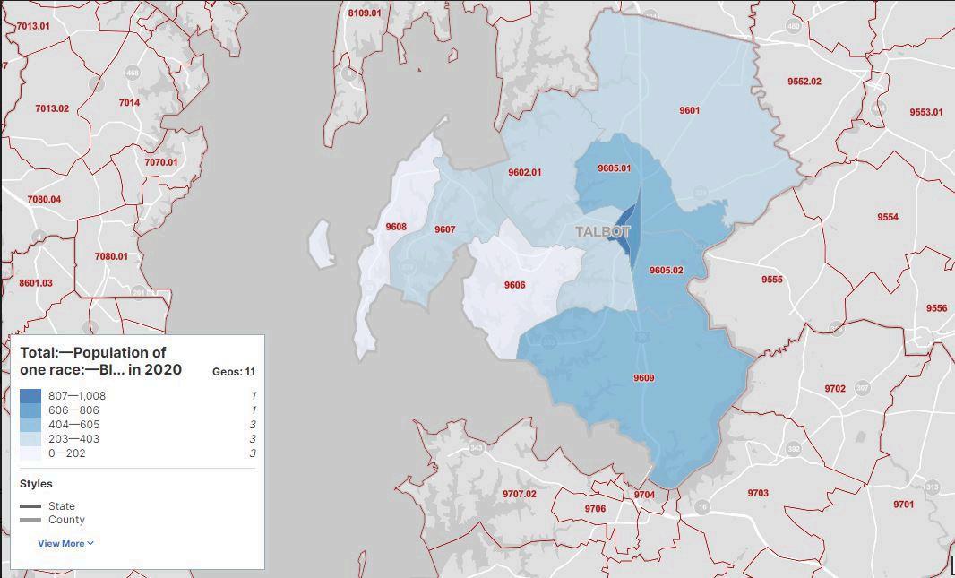
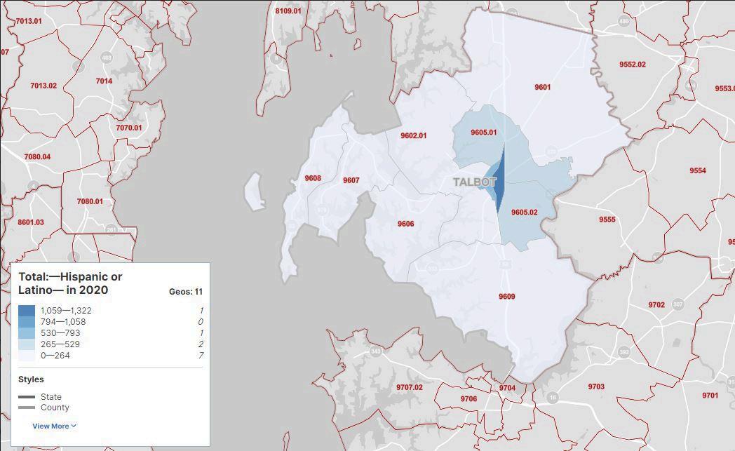
In2021,theMarylandLandUseArticlewasamendedtorequirethatallcomprehensiveplans includea“FairHousingAssessment”toensurethat they“affirmativelyfurtherfairhousing.”This referstotheobligationtopreventhousingdiscriminationandproactivelyaddresssegregationand otherbarriersthatlimithousingaccessbasedonrace,color,religion,sex,age,nationalorigin, familialstatus,ordisability.AsdefinedinSection2-401oftheHousingandCommunity DevelopmentArticle,thisincludestakingactivestepstocreateinclusivecommunitieswhere housingopportunityisnotrestrictedbythesecharacteristics.
TheHousingGoalsandObjectivesattheendofthischapterincluderecommendedactionstomeet thisrequirement.ThesefocusonpreservingEaston’sexistingaffordablehousing,increasingthe supplyofnewhousing,andpreventingthedisplacementoflow-andmoderate-incomehouseholds
TheTownofEastoniscommittedtofosteringaninclusiveandequitablecommunitywhereall residentshavefairaccesstohousingopportunities.Thiscommitmentiscentraltoourvisionofa vibrant,diverse,andthrivingtown
InlinewiththeFederalFairHousingAct,theMarylandFairHousingAct,andapplicablelocal ordinances,Eastonprohibitshousingdiscriminationbasedon:
• Race(includingassociatedtraitslikehairtextureandprotectivehairstyles)
• Color
• Religion
• Sex(includingsexualorientationandgenderidentity)
• Familialstatus(includingfamilieswithchildren,pregnantindividuals,andlegalcustodians ofchildrenunder18)
• Nationalorigin
• Disability(physicalormental)
• Maritalstatus
• Sourceofincome
• Militarystatus
TheTownwillactivelyworktoeliminatediscriminatorypractices,supportdiverseneighborhoods, andensurethatallresidentscanfindhousingthatmeetstheirneeds.Fairandequaltreatmentwill continuetobeintegratedintoourplanning,policymaking,andcommunitydevelopmentefforts.
Eastonfacestwodistincthousingchallenges.Thefirstisashortageofhousingforlow-and extremelylow-incomeindividualsandfamilies Thesehousingneedsoftenintersectwithbroader socialandfamilialchallenges,makingthempersistent.Despitethis,theTownmustcontinue and expand effortstoprovidehousingforthisgroup TheHousingAuthorityofTalbotCountyremains theprimaryprovider,buttheTownshouldalsosupportgroupslikeHabitatforHumanityof Choptankandsimilarorganizationsthatoffersafe,decent,affordablehomes
OneapproachworthrevisitingisalocalSelf-HelpHousingProgram,modeledafterasuccessful initiativeonthelowerEasternShoreledbyformerDelegateRudyCane SimilartoHabitat’smodel, theUSDA-supportedprogramenablesverylow-andlow-incomefamiliestobuildtheirownhomes togetherundersupervision,contributingasetshareoflabor(typically65%).Thisreducescosts
andmakeshomeownershipfeasible.Eastonpreviouslysoughtfundingforthisprogramthroughthe CommunityLegacyProgram,buttherequestwasdenied.Renewedeffortscouldhelpbringitto fruition
Thesecondhousingissueisthelackofinventoryforfirst-timeandmove-uphomebuyers.Easton’s recentresidentialdevelopmentsincreasinglytargethigh-incomebuyers,leavingfeweroptionsfor moderate-incomehouseholds.Thisgrowinggapinthemarketreducesopportunitiesforeconomic mobilityandlong-termcommunitydiversity
Worseningthissituationisthegeographicsegregationofhousingbyincome.Eastonisevolvinginto atownofincome-stratifiedneighborhoods verylow-incomehouseholdsinonearea, working-classresidentsinanother,andwealthierresidentselsewhere.Thiskindofseparation underminescommunitycohesion,asdiscussedintheCommunityCharacterElement.
Onesolutionistorequireallnewresidentialdevelopmentstoincludeasetpercentageofhomesat variedpricepoints.AnotableprecedentwassetintheEastonVillageontheTredAvonproject, whichoriginallycommitted10%ofbothattachedanddetachedunitsasaffordablehousing These unitsweretobeintegratedintothecommunity,indistinguishablefrommarket-ratehomes,and subjecttoresalerestrictionstomaintainaffordabilityHowever,thefinancialburdenofrealestate taxesandHOAfeeseventuallyledthedevelopertosubstitutein-lieucontributionstotheTown’s AffordableHousingFund
Developershavealsometaffordablehousingobligationsbybuildingunitsoff-siteorcontributingto theFund.Whilethishasprovidedsomeaffordablehomes,ithasdilutedtheoriginalgoalof integratinghousingtypeswithinneighborhoods
Tocreateamoreconsistentandequitableapproach,theTown’sAffordableHousingBoardproposed anInclusionaryZoningOrdinance,anideafirstsupportedinthe2010Plan Sincethen,theconcept hasbeenstudiedbytheBoardandtheAttainableHousingTaskForce,leadingtoaproposed ordinancepresentedtotheTownCouncilinearly2025andcurrently(October2025)pending potential action.
Additionalhousingpolicyoptionsunderconsiderationinclude:
• Expanding“MissingMiddle”housingtypestooffermorevariedandaffordableunits.
• CreatingTraditionalNeighborhoodZoningthatallowssmallerlots,mixeduses,and compact,walkabledevelopmentby-right.
• Modifyingthedevelopmentreviewprocesstostreamlineapprovalsforprojectsthatalign withtheTown’saffordablehousinggoals.
Theseinitiativesaimtoaddressbothaffordabilityandequitywhilesupportingamoreintegrated, inclusivehousingmarketinEaston.
Goal #1: Ensure that housing in Easton is safe, sanitary, structurally sound, and enhances neighborhood character.
Objectives:
● Maintainstrongfunding,staffing,andtrainingfortheTown’sBuildingInspection Department,andexpandtheRentalHousingInspectionProgram.
● Collaboratewithstate,county,andnonprofitpartnerstodirecthousingrehabilitationfunds toeligiblelow-andmoderate-incomehouseholds.
● Implementdesignstandardsthatpromoteamixofhousingtypesandvisuallyintegrate affordablehousingintothecommunity.
● Encouragedevelopmentpatternsthatsupportneighborhoodidentity,walkability,transit access,andefficientuseofinfrastructure.
● Preservenaturalfeaturesandcommunitycharacterthroughthoughtfulopenspacedesign, landscaping,andenvironmentalprotections.
Goal #2: Expand the supply of low-income housing in Easton.
Objectives:
● SupporttheHousingAuthorityofTalbotCountyandEastonAffordableHousingBoardin creatingbothrentalandownershipopportunitiesforlow-incomehouseholds.
● AmendtheZoningOrdinancetoencourageprivate-sectorapartmentdevelopmentand allowflexiblereuseofexistingorhistoricstructures.
● PartnerwithHabitatforHumanityofChoptankandsimilargroupstoidentifyandsecure sitesfornewaffordablehomes.
● LaunchaTown-ledSelf-HelpHousingProgramtoassistlow-incomefamiliesinbuilding theirownhomes.
"OUR DECISIONS ABOUT TRANSPORTATION DETERMINE MUCH MORE THAN WHERE ROADS OR BRIDGES OR TUNNELS OR RAIL LINES WILL BE BUILT. THEY DETERMINE THE CONNECTIONS AND BARRIERS THAT PEOPLE WILL ENCOUNTER IN THEIR DAILY LIVES — AND THUS HOW HARD OR EASY IT WILL BE FOR PEOPLE TO GET WHERE THEY NEED AND WANT TO GO " ELIJAH CUMMINGS
Transportationisaprimarydriveroflanduse andEastonisnoexception Theearliestsettlements inTalbotCountywerelocatednearnavigablewatersoutofnecessity.Easton’sindustrialbuildings, nowseeminglyoutofplace,wereoriginallylocatedalongaraillinethatservedtheareastartingin themid-1800s Morerecently,theTown’sexpansiontotheeasthasbeenshapedbyproximitytoUS Route50,amajorregionalhighway.
Thelinkbetweentransportationanddevelopmentisdeeplyrootedinhumanhistory,with communitiesformingalongcoasts,rivers,andtraderoutes.Inthemodernera,particularly followingWorldWarII,Americantransportationplanninghasfocusedoverwhelminglyon accommodatingprivateautomobiles.Thisauto-centricapproachhasbroughtconveniencebutalso ahostofunintendedconsequences environmentaldegradation,socialinequities,andinefficient landusepatterns
TheTransportationChapteraimsto:
● ReinforcetheTownCouncil’sstrategiccommitmentstomobility,access,andconnectivity.
● Updategoals,policies,andstrategiestosupportmultimodalimprovementsacrossEaston anditsgrowtharea.
● Advancea“CompleteNetworks”approach onethattracksandimprovestransportation optionsacrossallmodes,withanemphasisonsafety,connectivity,andequity
Eastonrecognizestheneedtorebalanceitstransportationsystembysupportingamultimodal networkthatincludeswalking,bicycling,transit,airtravel,andautomobiles.Adiverseand well-integratedtransportationsystemallowspeopleofallages,abilities,andincomestotravel
safelyandefficiently.Italsosupportseconomicdevelopment,environmentalsustainability,anda highqualityoflife.
Thegoalsandpoliciesinthischapterareorganizedintofivekeyareas:
1 IntegrationofLandUseandTransportationPlanning
2. CompleteNetworks
3. Non-MotorizedTransportation
4. Single-OccupancyVehicles
5. TransportationPlanningRequirements
Theseareasareguidedbysixcorethemesthatemphasizetheinterdependenceoftransportation, landuse,theenvironment,andsocialequity.Thesethemesbuilduponandreinforcethebroader goalsofthisComprehensivePlan:
1 Limitsprawlbycoordinatinglanduseandtransportationplanning
2. Providesafe,sustainable,andwell-connectedmobilityoptionsforallusers.
3. Expandinfrastructureforpedestrians,cyclists,andsharedmodesoftransportation.
4. Reducerelianceonsingle-occupancyvehicles(SOV).
5. Maintainandimproveroads,trails,andotherkeyinfrastructure.
6 Prioritizeequityintransportationplanningandprojectimplementation
Thesethemesandtheirrelatedpolicyareaswillbeexploredingreaterdepthinthefollowing sections.
Astheprimarypopulation,employment,andservicecenterinTalbotCounty,Eastonservesnotonly its18,000residentsbutalsothousandsofcountyandregionalresidentswhorelyontheTownfor work,shopping,anddailyactivities.Thisresultsinatransportationnetworkthatmust accommodatesignificantregionaldemand,muchofitoriginatingoutsidetheTown’scorporate limits.
Theaffordabilityofhousinginsurroundingareas,combinedwithpersonalpreferenceandregional employmentdynamics,meansthatmanypeoplechoosetoliveoutsideofEastonbutcommutein.
Accordingto2020US Censusdata,onlyabout3,200oftheTown’s11,860workerslivedinEaston Morethan8,600commutedinfromelsewhere.Atthesametime,over2,400Eastonresidents commutedoutoftownforwork The2022updateshowedthatoutof12,232workersinEaston, 9,190wereinboundcommutersand2,322wereoutbound.Intotal,morethan11,000people commuteintooroutofEastoneachworkday,underscoringtheTown’sregionalsignificanceandthe burdenonitstransportationinfrastructure.
Thislevelofregionaltrafficpresentsclearchallenges Easton’splanningeffortsmustmanage congestionwhilealsopromotinglandusepatternsthatsupportinfilldevelopment,maintaina compacturbanform,andencouragetransportationalternativestotheprivateautomobile.
Higherresidentialdensities,suchasthosealreadyfoundinpartsofEaston,createopportunitiesfor moreefficienttransportationoptions likepublictransit,walking,andbicycling.Thesemodes becomemorecost-effectiveandfeasibleasdensityincreases Forthisreason,Eastonmustcontinue toalignitslanduseandtransportationpoliciesto:
• Supportcompact,higher-densitydevelopmentinandnearemploymentandservicecenters
• Encourageinfillandredevelopmentinwalkable,connectedneighborhoods.
• Incentivizedevelopmentpatternsthatreducerelianceoncartravel
AmoreintegratedapproachtolanduseandtransportationplanningwillhelpEastonaccommodate regionaldemandwhilepreservingtheTown’sform,character,andqualityoflife
Easton’stransportationplanningstrategyprioritizesaCompleteNetworksapproach addressing theneedsofallusers,includingpedestrians,cyclists,drivers, andtransitriders ratherthanfocusingsolelyonautomobiles. ThisapproachbuildsontheprinciplesoftheCompleteStreets movementbutexpandsthemwithannualprogresstracking, system-wideassessments,andacommitmenttoequityand accessibilityacrossmodes.
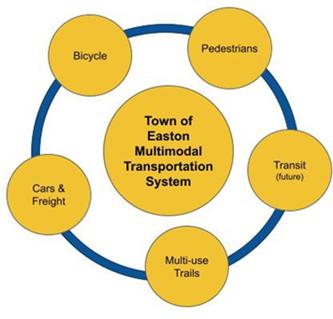
WhiletransitoptionsinTalbotCountyremainlimited,Eastonmustplanforfuturemultimodal infrastructure,includingthepotentialexpansionoftransitservicesastheTowngrows.Complete NetworksplanningalsosupportsEaston’sgoalsforcompact,walkableneighborhoodsandreduces thedemandforcontinuousroadexpansionbyofferingviablealternativestothesingle-occupancy vehicle(SOV)
TheTownaimstoproduceanannualinventoryandperformanceassessmentforeachmodal system pedestrian,bicycle,vehicle,andtransit whilealsoreportingonsystem-wideprogress andneeds.Theseassessmentshelpguideinvestmentprioritiesandaligninfrastructure improvementswithdevelopmentgoals
AkeycomponentofEaston’sCompleteNetworksstrategyisthecontinueddevelopmentofsafe, convenientinfrastructureforpedestriansandbicyclists.Thisincludesconstructingnewsidewalks, crosswalks,andbikeways,aswellasintegratingtheseelementsintoallnewpublicandprivate streetprojects.
TheEastonBicycleandPedestrianMasterPlan(originallyincludedinthe2010Planandintended tobeupdatedfollowingthisPlan’sadoption)servesastheblueprintforthiseffort.Itidentifies:
• A PrimaryPedestrianNetworkwithrecommendedsidewalkandintersectionprojects prioritizedbyneedandfeasibility.
• APrimaryBicycleNetworkandrecommendedbikewayprojectsprioritizedsimilarly
TheseplansareconsideredanextensionofthePlan.Theirimplementationisessentialtoenhancing non-automotivemobilityinTownandpromotingactivetransportationoptions
TheTowncontinuestoimproveconditionsforwalkingandbikingwhileencouragingfewervehicle trips,particularlythosemadebysingleoccupants.Thisdoesnotimplyeliminatingprivate vehicles Eastonwillcontinuetosupportawell-functioningroadnetwork butrecognizesthat auto-centricdevelopmentisnotsustainableforthelongterm.
CensusdatashowsEaston’stransportationnetworkisheavilyimpactedbyregionalinflowsand outflowsofworkers,shoppers,andserviceusers.Inthiscontext,theconstructionofpedestrianand
bicycleinfrastructureservesnotonlyEastonresidentsbutthebroaderregionalcommunityby reducingcongestionandexpandingtravelchoices.
Althoughprivatevehicleswillremainthedominantmodeformostregionalusersoverthenexttwo decades,technologicalshifts suchascar-andride-sharing,remotework,andautonomous vehicles arereshapingthetransportationlandscape Eastonwillcontinuetomonitorandadaptto thesechangeswhilemaintainingastrongemphasisonwalkable,connected,andmultimodal planning
Recognizingthatcongestionduringpeakperiodsisunavoidableincertaincorridors,Eastonisno longerplanningto“builditswayout”throughcontinuouswideningofroadsandintersections Instead,theTownprioritizesimprovementsthatenhancetransportationoptions,increase efficiency,andcreatesafe,comfortablestreetsforallusers.
Eastonintegratestransportationplanningwithinfrastructureinvestmenttomaximize cost-efficiency.Whenutilitiessuchaswater,sewer,orstormwatersystemsrequireupgrades,the Townseekstocoordinatetheseprojectswithtransportationimprovements suchasadding bikewaysorsidewalksidentifiedintheBicycleandPedestrianMasterPlan.
Forexample:
• AsphaltresurfacingtriggerssidewalkandcurbrampupgradesundertheAmericanswith DisabilitiesAct(ADA)
• Roadrepavingcanbepairedwithre-stripingtoaddbikelanes.
• Utilitycorridorimprovementsmaycoincidewithplacemakinginitiativesiffundingis aligned.
Inmanycases,improvementscanbefundedthroughnon-transportationsources(eg,utilitycapital budgets),allowingtheTowntoexpandmultimodalinfrastructurewithoutdrawingexclusivelyon transportationfunds.
Privatedevelopmentalsoplaysarole.Allnewdevelopmentandredevelopmentprojectsare requiredtocontributetothecostandconstructionofinfrastructureneededtosupportgrowth. Theseprojectsarereviewedforcompliancewithlocalandstatetransportationstandardsandmust addressconnectivity,safety,andoverallnetworkperformance.
UndertheTown’sDevelopmentRegulations,aTransportationImpactAnalysis(TIA)isrequiredfor certaindevelopmentprojectsexpectedtogeneratesignificanttrafficorthoselocatednear intersectionswheresafetyandcongestionarealreadyconcerns.TheTIAevaluatesandidentifies deficienciesandrecommendsmitigationstrategiesifneeded TheTIAprocessbeginswithascoping phasepriortotheformalsubmissionofatrafficstudywheretheTownandtheapplicantagreeupon themethodologiesbasedontheintensityoftheproposal,whicharegenerallyspeakingthose expectedtogeneratesignificantThestudyevaluatestheproject'simpactonthesurrounding network,identifiesdeficiencies,andrecommendsmitigationstrategies.Whenapplicable,additional requirementsmaybeimposedbyMDOTorforprojectslocatednearsignalizedintersectionswhere trafficcongestionorpublicsafetyconcernsalreadyexist.
¶
TheTIAevaluatesthelikelyimpactsofaproposeddevelopmentonthesurroundingtransportation network,identifiesdeficiencies,andrecommendsmitigationstrategiesifneeded.Off-sitemitigation measures wherenecessary mustcomplywithrelevantstateregulations,includingtheState EnvironmentalPolicyAct(SEPA).
¶
Justasacomprehensivestreetnetworkisnecessaryforefficientandsafevehicularflowatan acceptablestandard,itmustalsoservebicyclists,pedestrians,andtransitriders.Toencourage alternativemodesoftransportationandensuremobilityforallusers,theTownenvisionsInthe future,theTownenvisionsexpandingthescopeofTIAstoincludeamulti-modalimpactanalysis wherepedestrians,cyclists,andtransitridersaretreatedasequaltraffic.FutureTIAswillbe alignedwiththeTown'santicipatedCompleteStreetsclassificationsystem Thisensuresthatthe impactanalysisaccountsforallmodesoftravel,notjusttrafficcountsandtheinfrastructuredesign identifiesthespecifictypesofbicycleandpedestrianfacilitiesappropriateforthestreet's classification. ananalysisofimpactsonallmodesoftransportation,consistentwithexpected CompleteStreetstandardsandpolicies.
¶
TosupporttheTown’sgoalsforaseamlessnetworkCompleteStreetNnetworksgoals,allnew developmentabuttingsubstandardpublicstreetsisrequiredtoupgradeadjacentstreetsegmentsto currentEastonmultimodalstreetstandardswherefeasible ThesestandardsensurethatasEaston
grows,itstransportationinfrastructureissafe,accessible,andmultimodal,andfiscallysustainable byrequiringdevelopmenttocontributeitsfairsharetothepublicrealm.
¶
Requirementsvarybystreettype:
•Residentialstreetsinnewsubdivisionsmustincludeconcretecurbs,gutters,andsidewalks,unless aspecificexemptionisgranted.
•Arterialstreetsadjacenttonewdevelopmentmustbeimprovedformultimodaluse
¶ ThesestandardsensurethatasEastongrows,itstransportationinfrastructuresupportssafe, accessible,andmultimodaltraveloptionsforallusers
U.S.Route50hasbeenthesinglemostinfluentialforceshapingEaston’sgrowthanddevelopment patternsoverthepastseveraldecades particularlycommercialgrowth Theopeningofthe ChesapeakeBayBridgein1952gavemillionsofWesternShoreresidentsdirectaccesstothe EasternShore,drivingasurgeinbeachtraffic Entrepreneursrespondedbydevelopingfast-food restaurants,gasstations,andotherroadsideservicesalongRoute50toattractthesepass-through travelers
Route50alsofundamentallyaltereddevelopmentpatternsinEaston.Whatbeganasgrowthalonga bypasscorridoreventuallydrewmorecommercialusestowardit,withresidentialdevelopment fillinginbetweenthehighwayandthehistoriccore.Mostofthispost-1950sgrowthwas auto-orientedandsingle-useinnature,divergingfromtraditionalneighborhooddesign.
AfiscalanalysisbyUrban3(seeFigure2)highlightskeydifferencesbetweenpre-andpost-1952 development.First,relativelylittlelandwasdevelopedbeforetheBayBridgeopened.Second,land developedpriorto1952consistentlygeneratessignificantlyhigherfiscalvalueperacrethan post-bridgedevelopment.Together,thesetrendsreinforcethelinkbetweeninfrastructureandland usepatterns,andthehigherfiscalreturnofcompact,traditionaldevelopmentoversuburban sprawl.
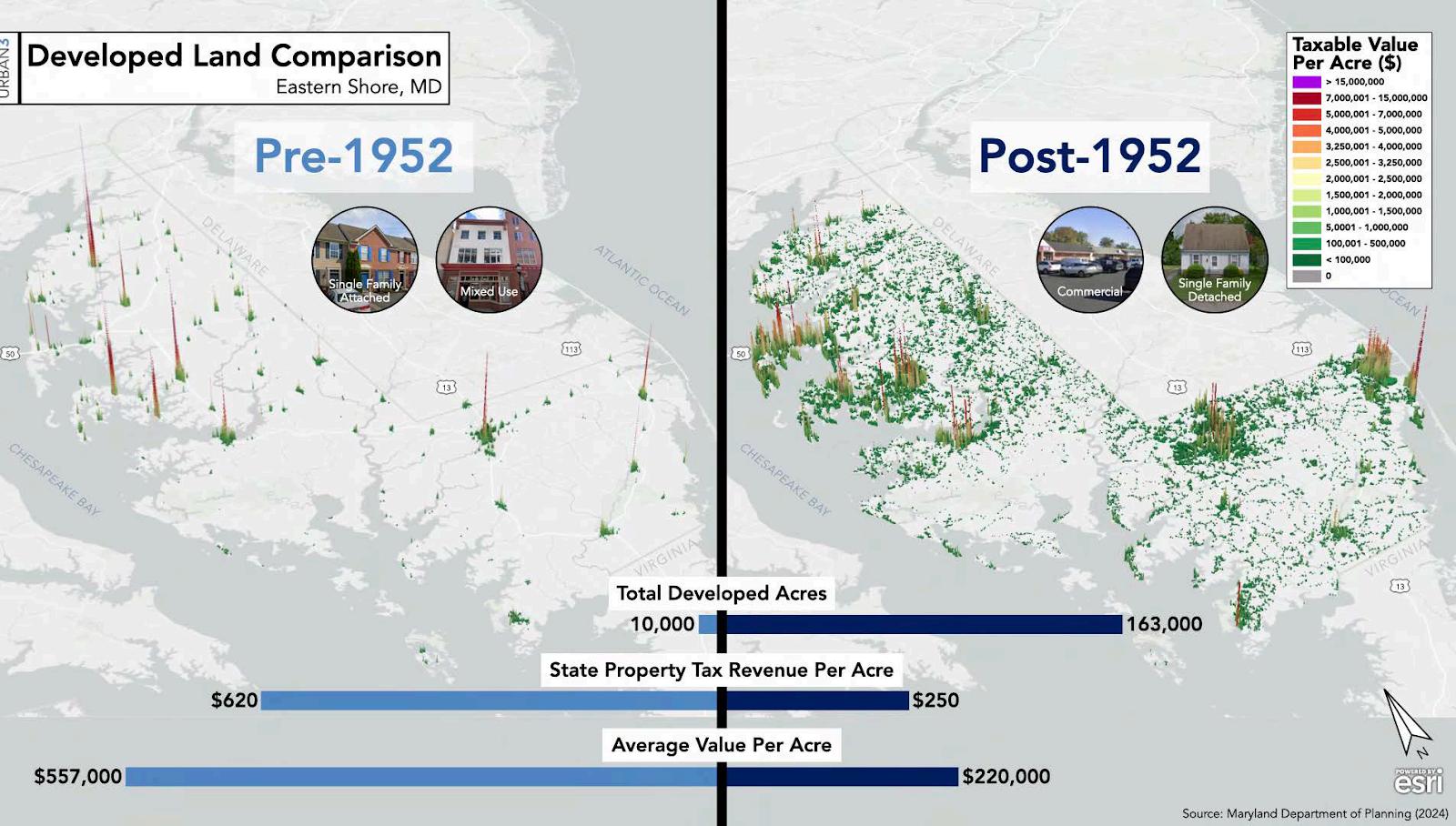
WhileRoute50hasbenefitedmanybusinesses,itsimpactsaremixed.Excessiveaccesspointsand thehighway’sattempttofunctionbothasahigh-speedregionalcorridorandasalocalserviceroad havecreatedserioustrafficcongestion,safetyconcerns,andneighborhooddisruption
Easton’sresidentsoverwhelminglyopposereroutingRoute50ontotheEastonParkway aposition consistentlyconfirmedineveryComprehensivePlansurveysincethe1990s TheParkwaywasbuilt inthe1960stoservewestTalbotresidentsbyprovidingnorth-southmobilityaroundEaston,not throughit ConvertingitintoanewRoute50wouldunderminethisfunction,addsignalized intersections,andrisksignificantenvironmentalimpacts particularlynearMD33andMD333. TheParkwaycannotandshouldnotserveasahigh-capacitybypass.
Instead,themostfavoredlong-termsolutionremainsanew,limited-accessbypasslocatedwelleast ofEaston similarinscopetotheSalisburyBypass.ThiswouldalleviatecongestionwithinTown, reducethrough-trafficdelays,andprovideanopportunitytorepurposetheexistingRoute50 corridorasalocal“Business50.”Thattransformationwouldallowforstreetnarrowing,improved safety,andredevelopmentofthecorridorintoamoreattractive,multi-modalgateway
Untilsuchabypassbecomesfeasible,theTownwillcontinuetoworkwiththeStateHighway Administration(SHA)toimprovetheexistingRoute50corridorthroughlandscaping,intersection upgrades,andaccessmanagement.
Along-standingprobleminEastonisthelackofeffectiveeast–westconnectivityTheParkwayhelps bypassdowntownfornorth–southtraffic,butofferslittlehelptothosemovingacrossTown betweenneighborhoodsoneithersideofRoute50 Asaresult,east–westtraveloftenfunnels throughresidentialstreets,creatingcongestion,cut-throughtraffic,andneighborhoodcomplaints.
Someimprovementshavebeenmade suchastrafficsignalsynchronizationalongRoute50 but largersolutionsareneeded.OnepromisingideaistorelocateMD309soitconnectswithRoute50 atthepointwheretheformerrailroadcrosses Fromthere,itcouldrunalongtherailcorridor beforerejoiningitsexistingalignment.Thiswouldnotonlyimproveeast–westconnectivitybutalso eliminatetheproblematicintersectionneartheairport,whereagrade-separatedinterchange wouldconflictwithflightpaths Theconcept,originallyproposedbySHA,hassupportfromlocal andregionalofficialsandshouldbeadvanced.
Planningforfutureroadimprovementsiscomplexandexpensive especiallywhenmultiple jurisdictionsareinvolved.WithinEaston’slimits,roadsaremanagedbytheTown,TalbotCounty, andtheStateofMaryland,eachwithdifferentobjectives Forexample,theState’spriorityforRoute 50isefficientregionaltravel,whileEastonandtheCountyprioritizelocalmobilityandsafety. Effectiveintergovernmentalcoordinationisessentialtoreconciletheseprioritiesanddeliver meaningfulimprovements
It’salsoimportanttorecognizethatRoute50isnowamajorfreightcorridor.A2022Stateof MarylandreportontheRuralOpportunitiestoUseTrafficTechnologyEnhancements(ROUTE) initiativenotedthatRoute50carriesover10,000trucksperdayandsupports$14billioninannual commodityflowFreightdelaysexceed107,000hoursannually,costingroughly$51millioninlost timeandfuel.Thecorridoriscriticalforagriculture,tourism,supplychains,andnationalsecurity assetssuchasWallopsIsland.
Goingforward,Eastonmustcontinueadvocatingforroadimprovementsthatbalancelocalmobility, regionalfreightneeds,andsafety whilestayingfocusedonlong-termgoalstoreduceauto dependencyandenhancequalityoflifethroughbettermultimodaltransportationoptions
EastonisintheprocessofdevelopingaCompleteStreetsframeworktoensurethedesignand operationofstreetssafelyaccommodatesallusers pedestrians,cyclists,transitriders, motorists regardlessofageorability.Thisapproachreflectsashiftawayfromtraditional car-centricdesigntowardonethatbalancestheneedsofalltravelmodesandemphasizessafety, accessibility,andcommunitycharacter.
CompleteStreetsprioritizelocalneedsandneighborhoodscale,ratherthansolelyfocusingonthe rapidmovementofthrough-traffic.Featuresmayincludesidewalks,bikelanes,busstops,safe pedestriancrossings,medianislands,curbextensions,trafficcalmingmeasures,andgreen stormwaterinfrastructure Whendesignedwell,CompleteStreetspromotesafertravel,improved mobility,publichealth,andplacemaking allcriticaltoEaston’slong-termlivability.
InJanuary2025,theTownofEastoninitiateditsformalCompleteStreetsplanningprocessby contractingwiththetransportationengineeringfirmWallaceMontgomery(WM).Thisfirstphaseof worklaysthefoundationforalong-termshiftinhowEastondesigns,prioritizes,andevaluates streetinfrastructure.TheoverallCompleteStreetsplanningeffortisanticipatedtospanseveral yearsandphasesofdevelopmentandimplementation
Eastonisuniquelyservedbyageneralaviationairportwithinitstownlimits.EastonAirport (NewnamField–ESN),locatedjustwestofMDRoute662andsouthofAirportRoad,isownedand operatedbyTalbotCounty.ThefacilityismanagedbyanAirportManagerunderthedirectionofthe CountyCouncil,withinputfromafive-memberAirportAdvisoryBoard
DesignatedintheFAA’sNationalPlanofIntegratedAirportSystems(NPIAS),EastonAirportis eligibleforfederalfunding Asageneralaviationfacility,itsupportsarangeofprivate,corporate, andpublicserviceaviationneeds.Itfeaturestwointersectingpavedrunways:
• Runway04/22:5,500feetlong
• Runway15/33:4,000feetlong
Bothhavefullparalleltaxiwaysandinstrumentapproaches AnFAAcontractairtrafficcontrol toweroperateson-site.
Theairportsupportsapproximately220basedaircraft,includingsingle-andmulti-engineplanes, jets,helicopters,andgliders.FourFixedBaseOperators(FBOs) EastonJetService,MarylandAir, NexGenFlightSolutions,andTridentAviation offerawidearrayofservices,including:
• Aircraftfueling(100LLandJetA)
• Aircraftparking(tie-downs,T-hangars)
• Aircharterservices
• Rentalcars,hangarspace,andcatering
• Flightplanningtools,weathercenters,andapubliccafe
• Meetingspaceandfitnessamenities
Additionalaviation-relatedbusinessesofferaircraftrepair,sales,anduniqueexperiencessuchas biplaneridesthroughAloftBiplaneRides.FlightinstructionandrentalsareprovidedbyTrident AviationandEastonAviation.
Theairportalsoplaysakeypublicsafetyrole.TheMarylandStatePolicebaseamedevachelicopter atthesiteforemergencymedicaltransport,searchandrescue,andlawenforcementmissions. TalbotCountyEMSoperatesfiveAdvancedLifeSupportunitsfromtheairport,improvingresponse timesandaccesstocriticalcare.
EastonAirport(ESN)ranksamongthetopthreebusiestgeneralaviationairportsinMaryland, reflectingitscriticalroleintheregion’stransportationandeconomicsystems.Accordingtothe MarylandAviationAdministrationandrecentreports,ESNsupportsahighvolumeofaircraft activityandcontributessignificantlytothelocaleconomy
Based Aircraft (2023)
• Single-engineaircraft:143
• Multi-engineaircraft:24
• Corporatejets:20
• Helicopters:3
• Total:190basedaircraft
Annual Aircraft Operations (2023)
• Localgeneralaviation:44%
• Transientgeneralaviation:31%
• Military:20%
• Airtaxi:5%
• Totaloperations:73,543annually
A2023statewidestudyofairporteconomicimpactsfoundthatEastonAirportgenerated:
• 542totaljobs
• $36.9millioninpersonalincome
• $113millioninstateandlocaltaxrevenue
• $91.4millionintotalbusinessrevenue
Thesenumbersdemonstratethattheairportisnotonlyatransportationassetbutamajor economicdriverforTalbotCountyandthebroaderMid-Shoreregion.
Astheairporthasgrowninoperationsandprominence,conflictswithadjacentresidential neighborhoodshavealsoincreased mostnotablyrelatedtonoise,traffic,andtheperceptionof encroachment.Inresponse,TalbotCountyhasenactedzoningmeasuresandacquiredavigation easementsonsurroundingpropertiestolimitincompatibleusesandprotectaviationoperations TheCountyplanstocontinuesecuringsucheasementstopreservetheairport'slong-term functionality
OntheTownside,whilethelandimmediatelysurroundingtheairportiszonedforindustrial uses whichisgenerallycompatiblewithaviation therearecurrentlynospecialairport-related zoningprotectionsinplace.TheTownmayconsiderrevisingitszoningordinanceinthefutureto incorporateairportoverlayorcompatibilitydistrictstobettermanagepotentiallanduseconflicts, particularlyinareasclosetoapproachanddeparturepaths
WithinEaston’sjurisdiction,theprimaryconcernisnotsafetybutnuisance especiallyinthe NorthEastonneighborhoodsandadjacentunincorporatedCountylands.Aircraftnoise,fumes,and vibrationsareongoingquality-of-lifeissuesfornearbyresidents Abalancedapproachisneeded: residentsshouldacknowledgethepresenceofalong-standingregionalairport,whiletheairport shouldseektochannelexpansionandhigh-impactoperationstowardnon-residential,industrial, andundevelopedlandtomitigatedisturbances.
Theairport’smissionemphasizesservice,safety,andcommunityresponsibility:
Talbot County’s Easton Airport is and will remain the Mid-Shore’s premier non-commercial general aviation airport, providing outstanding service and support for private, corporate, and government tenants, transient aircraft users, and the Talbot County community at large. It will be a good neighbor by being sensitive to environmental concerns and will support education, emergency services, medical evacuation, and law enforcement activities. The airport will prioritize safety and security while aligning with the goals of the County’s Comprehensive Plan
TheTownofEastonsupportsthecontinuedoperationandthoughtfulgrowthofEastonAirportand recognizesitsimportanceforeconomicdevelopment,publicsafety,andregionalmobilityHowever, theTownalsoemphasizestheimportanceofequitablelanduseplanningtominimizeimpactson residentialcommunitiesandensurelong-termcompatibilitybetweenaviationoperationsand surroundingneighborhoods
PortfacilitiesfortheTownofEastonarelocatedatEastonPoint,atriangularpeninsulaborderedon twosidesbytheTredAvonRiver.TheareacommonlyreferredtoasEastonPointextendsinlandto theEastonParkway,althoughmuchofthelandremainsoutsidethecorporatelimitsoftheTown TheonlyparcelswithinTownboundariesincludetheformerPublicWorksyard(nowrepurposed asaWaterfrontPark),theTalbotCountyPublicWorksandEmergencyManagementoffices,the LondonderryRetirementCommunity,andafewsmallinterveningparcels.
ThecurrentmixoflandusesatEastonPointisvaried.Atthetipofthepeninsulaisasmallmarina andaheavilyusedpublicboatramp Therearealsoseveralindustrialusersthatrelyonriveraccess forthedeliveryofbulkmaterials.AlongthecorridorclosertotheParkwayaretheCounty’sPublic
Worksfacility(nowintheprocessofrelocating)andtheLondonderryseniorlivingcomplex.Other interveningparcelsincludelow-densityresidentialpropertiesandaginginfrastructure,including theoldTownPublicWorksyard
Thelong-termfutureofEastonPointremainsuncertain.Theareahasbeenwidelyrecognizedforits redevelopmentpotential,givenitswaterfrontaccessandproximitytodowntown Many stakeholdersenvisionashiftawayfromheavyindustrialusetowardamoremixed-use,recreational, andresidentialvision Thiscouldincludeexpandedmarinafacilities,improvedpublicwaterfront access,parksandopenspace,andhigher-densityresidentialandcommercialdevelopment.
ThisvisionwasfurtherarticulatedintheEastonPoint/PortStreetSmallAreaPlan,referencedin theImplementationChapter.Thatplansetsforthaframeworkforpotentialannexation, infrastructureimprovements,andlandusechanges,shouldredevelopmentopportunities materializeinthefuture
RailservicetoEastonandthebroaderTalbotCountyareahasbeendiscontinuedformanyyears Mostoftheformerrailrights-of-wayhaveeitherbeenretainedbytheMarylandStateRail Administrationorrevertedtoprivateownership Asaresult,therestorationoffreightorpassenger railserviceisnotanticipatedduringthisplanningperiod;however,oldrailbedsserveasgood bonesfortheTown’sBicycleandPedestriannetwork,whichisexploitedbelow
Toooften,transportationplanningfocusesnarrowlyonroadways,withminimalattentionto non-automobilemodes Walking ourmostbasicformoftransportation isfrequentlyoverlooked, alongwiththeinfrastructurethatsupportsit.Eastonisactivelyworkingtochangethat.Aspartof theTown’sbroader“CompleteStreetsinitiative”pedestrianandbicyclenetworksarenowacentral focusofinfrastructureplanningandinvestment.
InEaston’solderneighborhoods,sidewalkshavelongbeenadefiningfeature Inrecentyears,many oftheseareashavebenefitedfromtargetedsidewalkupgradesandstreetscapeenhancements. Sincetheearly1980s,thePlanningandZoningCommissionhasrequiredsidewalksinallnew subdivisions.However,someneighborhoodsdevelopedinthe1950sthrough1970slackthis infrastructureentirely,forcingpedestrianstoshareroadwayswithvehicles asignificantsafety concern Theseareasarenowprioritiesforretroactivesidewalkinstallation
BicycletravelisalsoreceivinggreaterattentioninEaston’stransportationframework Bicycling offersalow-cost,sustainabletransportationoptionandisincreasinglyeligibleforfederalandstate infrastructurefunding Projectssuchasbikelanesandmulti-usetrailsareparticularlywell-suited toIntermodalSurfaceTransportationEfficiencyAct(ISTEA)grantsandMaryland'stransportation fundingprograms,whichnowrequirecomprehensiveplanstoaddresspedestrianandbicycle mobility.
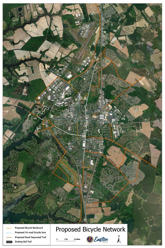
TheTownofEastoncurrentlydoesnotoperateitsownpublictransportationsystem,andno municipaltransitservicesareexpectedtobeintroducedduringthecurrentplanninghorizon However,residentsandworkersdohaveaccesstoDelmarvaCommunityTransit(DCT),aregional transitserviceoperatedbyDelmarvaCommunityServices,towhichtheTowncontributesannually DCTprovidestwofixedroutesthroughEaston RouteCandRouteD operatingfrom7:15a.m.to 5:15pm ASt MichaelsShuttlealsorunsfrom6:00a.m to5:30pm FiscalYear2023ridership was:
• RouteC:8,337riders
• RouteD:5,868riders
• St MichaelsShuttle:6,030riders
Whileridershiphasdeclinedsince2010(particularlyonRouteC),publictransitremainsavital serviceformanyresidents,includingseniors,workers,andindividualswithoutaccesstoacar Lookingahead,theTownremainsopentoexploringexpandedtransitoptions,includingpotential serviceincreasesfromDCTorotherproviders AspartoftheStateAgencyreviewprocess associatedwiththeDraftofthisPlan,MarylandTransportationofficialscommentedthatmany communitiesofaboutthesamepopulationasEastonhavebeenabletomaintainacirculatorbus system ThisissomethingweshouldexplorefurtherduringthisPlanningperiodas,amongother benefits,thisispotentiallyonewayinwhichthedisparatepartsofEastoncanbebroughtcloser together(and,inarelativelysustainablemanner)
EastonshouldalsobegindiscussionswithStatetransportationagenciesregardingtraveldemand managementstrategies,suchasofficialPark-and-Ridefacilities Currently,someresidentsare informallyusingbusinessparkinglotsforcommuterparking anindicatorofunmetdemandthat mayjustifythecreationofdesignatedfacilities. Itisalsoimportanttorememberthatwhilenot everyproject isappropriateforconstructionofanewroad,allareimportantforconsiderationof expandedorenhancedconnectivity. AprominentexampleofsuchprojectsisthenewHospital. Thisfacilitywouldseemtobealogicalcandidateforatransitstopgivenitsroleasanimportant communityservice,aswellasmajoremployer. Ataminimum,anyhospitalemployeeswho currentlywalktotheexistingsiteonSouthWashingtonStreetwillneedanewtransitoptiontoget toworkatthenewlocation.
TheTransportationMapillustrateskeyproposedenhancementstoEaston’smultimodal transportationnetwork Theseimprovements,summarizedbelow,areconceptualatthis stage exactdesigns,fundingmechanisms,andconstructiontimelinesarelargelyundefined.Most projectsareexpectedtobecompletedinconjunctionwithadjacentpropertydevelopmentor fundedthroughtheTown’simpactfeesoracombinationofTown,County,orStateresources.These proposalsarealsosubjecttorevisionastheCompleteStreetsStudyisfinalized
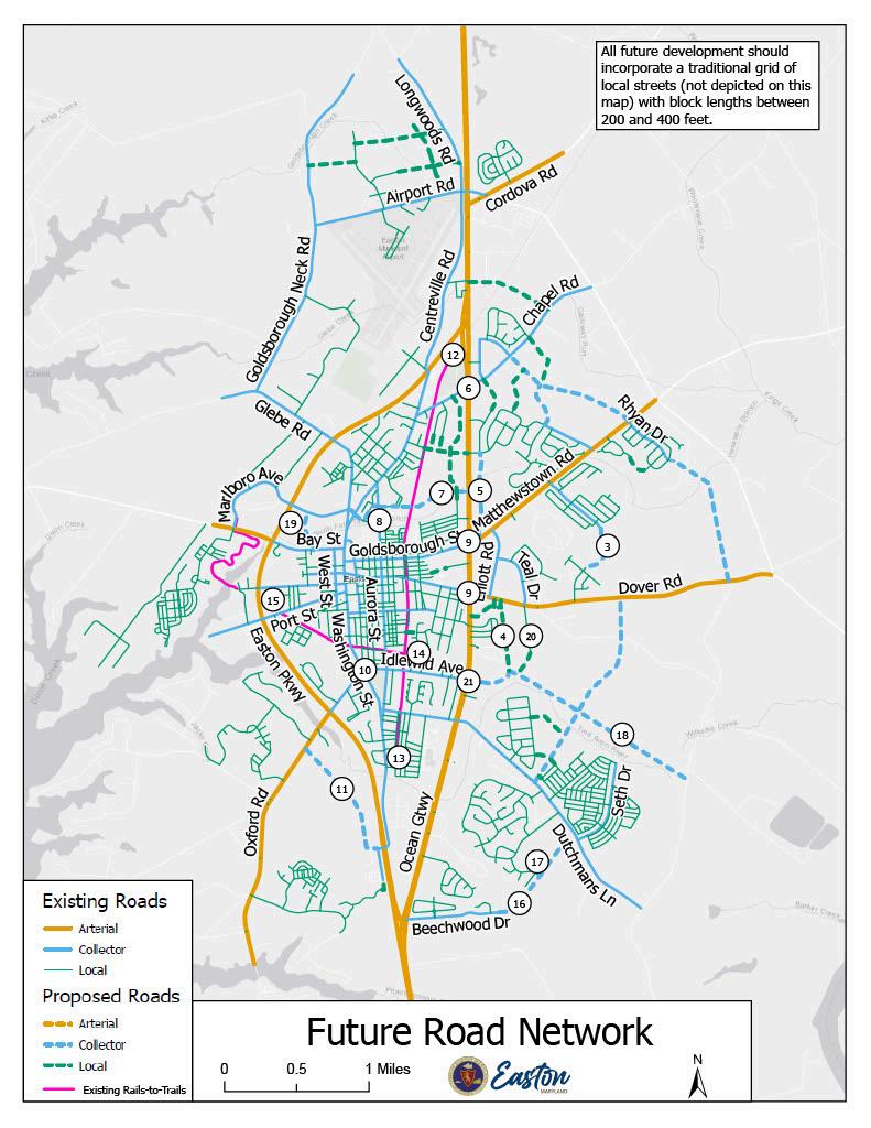
Future Map 7: Road Network
1. Grade-Separated Crossing of Route 50
OneofEaston’shighestprioritiesisaddressinglocaltrafficdelayscausedbycongestiononUSRoute 50.Agrade-separatedcrossingwouldsignificantlyimproveeast-westconnectivity.
2. East Side Residential Collector Grid
Replacingasinglecollectorroutepreviouslyproposedinthe2004Plan,theTownnowsupportsa gridnetworkoflocalstreetsontheeasternsideofEaston.Thisapproach mirroringthetraditional streetgridofthehistorictowncenter supportsconnectivityanddispersestrafficflowThe CompleteStreetsStudywillfurtherevaluatethisconcept.
3. June Way Extension
ThisprojectwouldextendJuneWayfromWaylandsSubdivisionsouthtoconnectwithFisherRange Road,eventuallyformingpartoftheEastSideCollectorGridmentionedabove
4. Clifton Road Improvements
CliftonRoadwouldbeextendedtoconnectDoverRoadandChesapeakeAvenue,offeringresidents ofNorth,Middle,andSouthCliftonanalternativeroutethatavoidsRoute50.
5. East Side Route 50 Service Road
AnewserviceroadbehindbusinessesalongtheeastsideofRoute50(betweenMatthewstownand ChapelRoads)wouldallowinternalcirculationwithoutrepeatedentriesontoRoute50,relieving trafficcongestionandimprovingsafety.
6. Chapel Road/Route 50 Intersection Improvements
Thisbusyintersectionwillrequirecapacityenhancementstoaccommodatefuturedevelopment, includingEastonCommonsandsurroundingparcels Recentupgradeshaveincludedsignal rephasing;furtherimprovementsareexpectedbasedonevolvingtrafficconditions.
7. Norris Taylor Drive
Thisnewsignalizedaccessroad,developedwiththeRoyalFarmsandBurgerKingprojects, improvescirculationonthewestsideandenhancesaccesstoJohnFFordPark Itmaysupporta futureWestSideServiceRoadextendingCalvertStreetnorthtoChapelRoadthroughtheRTC property.
8. East-West Connector
Thislong-standingproposalenvisionsconnectingMarlboroAvenuewithCreameryLane,Aurora ParkDrive,MagnoliaStreet,andeventuallyRoute50viatheRTCproperty.Portionsoftheroute couldcontinueacrossRoute50toElliottRoadandMulberryDrive.Phasedimplementationis expected,usingimpactfeesandpotentiallybeginningwithpedestrianorbicycleimprovements beforefullstreetconstruction.
9. Route 50 Intersection Upgrades (Goldsborough and Dover Streets)
TheseintersectionscontinuetorankamongtheworstinEastonintermsofcongestionanddelay. ImprovementsareessentialeveniftheEast-WestConnectoriscompleted Dedicatedturnlanesand expandedcapacityshouldbeexplored,andadditionalright-of-wayacquisitionmaybenecessary.
10. “Five Corners” Intersection
Thisunusualconvergenceoffiveroads(Washington,Harrison,Idlewild,Peachblossom)near IdlewildParkisapersistentcongestionpoint Aroundaboutisunderconsideration,alongwitha newsmartsignalsystemdesignedtoimproveflowandreducedelaysinthenearterm.
11. Tristan Drive to Oxford Road Connector
ThisproposedroutewouldconnectTristanDrivewithMDRoute33(OxfordRoad),creatinganew east-westcorridorandreducingpressureontheexistingParkway/OxfordRoadintersection CoordinationwithTalbotCountyisneeded,especiallyinlightoftheCounty’srecentacquisitionof theadjacentPoplarHillFarmproperty.
12–15. Rails-to-Trails System Extensions
Significanttrailsystemexpansionsareproposedinalldirections:
12.Northward,acrossRoute50,followingthehistoricrailbed.
13.Southward,acrossEastonParkwaytolinkwiththeCooke’sHopetrailsystem.
14.Eastward,alongChesapeakeAvenue.
15 WestwardutilizingthepedestrianbridgeovertheTredAvonRiverfundedbyEastonVillage developersandpotentiallyontowardsSt.Michael’s.
Segmentsofthesetrailextensionshavealreadybeencompletedinrecentyears,andtheTown intendstocontinuetheseenhancementsasopportunitiesarise
ThisproposedextensioninvolvesthesegmentofBeechwoodDrivelocatedadjacenttothe Lakelandsproject.ItwouldconnectthecurrentdeadendtoDutchman’sLane,justeastofEaston ClubEast. Wherefeasible,thisextensionshouldincludeamulti-usetrailtoenhancenon-motorized mobility.
HemlockLanecurrentlyterminateswithinTheWoodsatStoneyRidgesubdivision.Thisproposal wouldextendtheroadwayeastwardtoconnectwiththeproposedBeechwoodDriveExtension, formingpartofthebroaderEastSideResidentialCollectorGrid.Thisgridsystem,whichprioritizes multipleinterconnectedlocalstreetsratherthansinglelargecollectors,isintendedtoimproveeast sidecirculationwhilediscouragingexcessivecut-throughtraffic.
Apublicright-of-wayforChesapeakeAvenuealreadyexistsandoffersasignificantopportunityto provideeast–westaccessacrossalargelyundevelopedareabetweenDutchman’sLaneandChilcutt Road.Intheshortterm,constructionofapedestrian/biketrailalongthiscorridorwouldbenefit nearbyneighborhoods.Asdevelopmentoccurs,additionalright-of-wayacquisitionshouldallowfor aco-locatedroadwaythatcouldultimatelyintersectRoute50atornorthofIdlewildAvenue This extendedIdlewildcouldthenserveasthenewvehicularconnection,whileChesapeakeAvenue wouldsupportagrade-separatedpedestrianandbicyclecrossing
(19) Bay Street to Marlboro Avenue Connector
Thisproposalwouldformalizeanexistinginformalconnectioncurrentlyusedbydriversviaa networkofparkinglotsandprivatedrives.TheconnectorwouldprovideimprovedaccesstoTalbot CountygovernmentofficeslocatedintheBayStreetCondominiums Whilenotamajortrafficroute, thisconnectorwouldimprovecirculationandreduceconfusionforlocaltrafficandvisitors.
(20) Industrial Park Road Extension
IndustrialParkRoadcurrentlyservestheCliftonIndustrialPark,annexedintoEastonin2007.This extensionwouldpushtheroadsouthwardtomeettheproposedChesapeakeAvenuealignment. Oncebuilt,itwouldcreateavaluablenorth-southconnectionforresidentsofStoneyRidge,Easton
ClubEast,andfutureneighborhoods,offeringanalternatepathtoDoverRoadviaasignalized intersectionatTealDrive.
(21) Idlewild Avenue Extension
IdlewildAvenuecurrentlyterminatesatUSRoute50.Thisproposedextensionwouldcontinue IdlewildacrossRoute50,ideallyviaagrade-separatedcrossing,tomeettheproposedChesapeake Avenuecorridor.SuchaconnectionwouldrelievepressureonnearbyintersectionsatDutchman’s LaneandDoverRoad,improveeast-westconnectivityforvehicles,andprovideopportunitiesto separatepedestrianandbicyclemovementsfromhighwaytraffic.
Goal #1: Provide a Functional and Efficient Road Network.
Objectives:
● Maximizethecapacity,safety,andefficiencyoftheexistingstreetandhighwaysystem.
● Improveaccessto,andmovementwithin,theCentralBusinessDistrict
● ImprovetheRoute50circulationsystem,focusingonseparatingthroughandlocaltraffic.
● ConsolidatedrivewayaccesspointsonRoute50anddevelopanintersectioncontrolplanto reduceleftturns.
● Buildaconnectednetworkoflocalroadwaystosupportexistingcommunitiesandplanned development,whilereducinglocalrelianceonRoute50.
● DevelopaSmallAreaDesign/TransportationPlantoevaluateoptimalstreetandtrail networksonEaston’seastsideandGrowthArea.
● Discouragestripdevelopmentandpromoteclusteringofdevelopmentatdesignatednodes alongRoute50.
● Improveeast-westaccessthroughouttheTown,includingatGoldsboroughandDover intersections.
● Requiregriddedstreetsystemsinnewdevelopmentwithprovisionsforpedestriansand bicycles.
● Wherefeasible,retrofitexistingsubdivisionstocreatenewroadconnectionsandimprove connectivity.
● WorktoreducethegrowthofcommercialaccesspointsonRoute50.
● CoordinatecloselywithSHAonimprovementstoallstreetsthatintersectRoute50.
● ImprovetheappearanceandfunctionofRoute50frontageareas;prioritizesolutionsthat enhancetheexistingcorridorratherthanshiftingtraffictoEastonParkway.
● Supportlong-termeffortstoconstructaRoute50bypasseastofTown,pairedwith convertingtheexistingRoute50toamultimodalboulevard.
● Enhancepublictransportationoptionsandservices.
● Evaluatefeasibilityandlocationofaformalpark-and-ridelotinEaston.
Goal #2: Expand the Town’s Trail System and Support Active Transportation.
Objectives:
● CollaboratewithMDOTtopursuefundinganddesignforagrade-separatedpedestrianand bicyclecrossingofRoute50atChesapeakeAvenue.
● ImplementthegoalsandrecommendationsoftheBicycleandPedestrianMasterPlan.
● CoordinatetrailimprovementsandconnectivitywithTalbotCountyandregionalpartners.
● Includesafeandeffectivecrosswalksaspartofallmajorintersectionimprovementson Route50andEastonParkway.
Goal#3: Manage Airport Growth While Minimizing Community Impacts.
Objectives:
● Guidelanduseneartheairporttoavoidincompatibledevelopmentthatcouldrestrictfuture airportoperations.
● CoordinatewithEastonAirportofficialstoreviewandrefinepoliciesaimedatmitigating noiseandotherimpactsonadjacentneighborhoods.
Goal #4: Link Land Use and Transportation to Support Smarter Growth.
Objectives:
● UsethisComprehensivePlan,SmallAreaPlans,andmixed-usedistrictstoincentivizeinfill andprioritizemultimodaltransportation.
● PursuethenecessarystepstobuildaTransportationNetworkModel anddevelopa ComprehensiveTransportationPlanasanadjuncttothisComprehensivePlan.
● Promotecompactlandusepatternsandhigher-densitydevelopmentneartransitcorridors
● Acknowledgethatcongestionmayoccurindenserareas,butprioritizesafety,connectivity, andmultimodalaccessovercapacityexpansion
● Developastrategictransitplanlinkingkeydestinationssuchasemploymentcenters, schools,parks,andshopping
● Encourageactivetransportationoverdrivingtoimprovehealthandreduceenvironmental impacts
● Supporttransit-orienteddevelopment(TOD)alongprimarytransitroutesby:
○ Identifyingzoning,densities,andlandusepatterns;
○ Requiringdesignreviewforallnewdevelopment;
○ Promotingmixed-usedevelopmentanddiscouragingauto-orienteduses;
○ Encouragingdevelopmentpatternswhichreduceon-siteparkingrequirementsand encouragesharedparking;and
○ Requiringbicycleparkingfornewdevelopment.
● CoordinateTODeffortswithtransitproviderstomaintainorenhanceservicelevels
● CollaboratewithTalbotCountyonunifiedmultimodalinfrastructurestandardsforthe EastonGrowthArea.
● RequireMultimodalTrafficImpactStudiestoconsidernearbytransportationcorridorsand intersections,notjustthosewithinandimmediatelyadjacenttoproposedprojects
Goal #5: Provide Safe, Well-Connected, and Sustainable Transportation Options.
Objectives:
● Fillmissinggapsinthemultimodaltransportationnetworkforallusers,including pedestrians,cyclists,transitriders,freight,andprivatevehicles
● Designtransportationimprovementsthatprioritizesafetyforvulnerableusers.
● Ensuremobilityoptionsforpeoplewithspecialtransportationneeds,includingchildren, seniors,low-incomepopulations,andpersonswithdisabilities.
● ExpandtherequiredscopeofTrafficImpactStudiestoincludeananalysisanddiscussionof theimpactsofproposedprojectsonallmodesoftransportationsothatourtransportation networkbecomestrulymultimodal.
Goal #6: Increase Infrastructure for Non-SOV Travel.
Objectives:
● IntegrateBicycleandPedestrianMasterPlanrecommendationsintopublicstreet improvementswherefeasible.
● RequireallnewdevelopmenttobuildsidewalksalongpublicstreetsperTownstandards, withseparationfromtrafficwherepossible.
● AccommodatebicyclistsonarterialstreetsidentifiedintheMasterPlan,constructedwith permeablematerialswherefeasible.
● Establishanadministrativewaiverprocessforcaseswhererequiredimprovementswould servenoclearpublicpurpose.
● PrioritizeSafeRoutestoSchoolthroughcoordinationwithTalbotCountyPublicSchools
● Provideincentivesforprivatedevelopmenttoconstructsidewalkandbikeway infrastructure
● UseTransportationDemandManagement(TDM)andTransportationSystemManagement (TSM)strategiestoimproveefficiencyandsafety
○ TDMActions:
■ Educatethepublicaboutwalkingandbikingoptions
■ Implementcompact,transit-supportivedevelopmentstrategies.
■ TrackandreportprogresstowardshiftingmodeshareawayfromSOVs
■ RequireCommuteTripReductionprogramsforlargedevelopments.
■ Supportcarpoolingandridesharinginitiatives.
■ Reformparkingstandardstoimprovepedestrianenvironments
○ TSMActions:
■ Completebikeandpedestriannetworkstoimprovepublichealthandreduce emissions
■ Explorebikeshareprogramsandlocalconnectivityimprovements.
■ Identifyandpursuefundingsourcestoimplementmultimodal improvements.
Goal#7: Reduce Reliance on Single-Occupancy Vehicles (SOVs).
Objectives:
● DecreaseSOVtripswhileencouragingtripsmadebywalking,biking,transit,and ridesharing.
● TracktransportationmodeshareusingstandardizedCensusdataandreportfive-year averagesannually.
● WorkwithCountyandStatepartnerstodevelopalocalCommuteTripReductionprogram.
● AdvocateforstrongerMDOTsupportofsidewalk,bikeway,andtransit investments particularlyalongstatehighwaysservingEaston.
Goal #8: Maintain and Improve Streets, Trails, and Related Infrastructure.
Objectives:
● UseCompleteStreetstandardstoensuretransportationconcurrencyfornewdevelopment, avoidingunnecessaryroadwideningforvehicletraffic.
● Allocatesufficientfundingformaintenanceofsidewalk,bikeway,androadwaysystems.
● Designandconstructtransportationfacilitiestoavoidormitigateenvironmentalimpacts, consistentwithCriticalAreasOrdinancerequirements.
● Developimprovedmetricsforanalyzingnewvehicletrafficimpactsonpedestrians, bicyclists,andtransitservice.
● Applymultimodalstreetdesignstandardstoallnewdevelopment.
● RequestCountyandStatehighwayprojectstoincludepedestrianandbikesafety improvements.
● Retrofitexistingstreetswithgreeninfrastructureandtrafficcalmingwhereappropriate.
Goal #9: Address Transportation Equity in All Projects.
Objectives:
● Provideequitableaccesstopedestrianandbicycleinfrastructurethroughinclusivepublic engagementandtargetedcapitalinvestment.
● Investinunderservedneighborhoodstoexpandpedestrianandbicyclefacilities.
● Ensureallresidents regardlessofage,income,race,orability haveopportunitiesto participateinandbenefitfromtransportationinvestments.
● Developoutreachmaterialsinmultipleformatsandlanguagestoengageallsegmentsofthe Eastoncommunity
“INVESTMENT IN INFRASTRUCTURE IS A LONG TERM REQUIREMENT FOR GROWTH AND A LONG TERM FACTOR THAT WILL MAKE GROWTH SUSTAINABLE. ”
CHANDA KOCHHAR
A. PURPOSE
CommunityFacilitiesandServicesformthebackboneofEaston’sinfrastructureandqualityoflife. Thischapteraddressesthekeypublicservicesandutilitiesthatsupportdailyliving,guide development,andensurepublichealthandsafety.Theseincludewaterandsewerservices,solid wastemanagement,police,fireandrescue,andotheressentialfacilities
ThechapterprovidesaconciseoverviewofthefacilitiescurrentlyservingEaston,alongwitha discussionoffutureneedsbasedonprojectedgrowth Itincorporatescommunityinputgathered duringthePlanUpdateprocessandoutlinesgoalsandobjectivestoensurethatEaston’spublic serviceskeeppacewithdevelopment.
WhilenewerelementssuchasWaterResourcesandMunicipalGrowthmayoverlapwithtopicsin thischapter,theComprehensivePlanensuresallstatutoryrequirementsareaddressed evenif theyappearinseparatechapters ForCommunityFacilities,theStateofMarylandprovidesthe followingguidance:
Maryland Statutory Requirements
A CommunityFacilitiesElementmust:
(a)Projectthemostappropriateanddesirablepatternsforthelocation,character,andextentof publicandsemi-publicbuildings,land,andfacilities onaschedulethatextendsasfarintothe futureasisreasonable
B. Itmayalsoincludeplanningfor:
• Placesofworship
• Firestations
• Hospitals
• Institutions
• Jails
• Libraries
• Parksandrecreationareas
• Policestations
• Schoolsandeducationalfacilities
• Culturalfacilities
• Socialwelfareandmedicalfacilities
• Otherpublicofficesoradministrativebuildings
Someofthesetopicsareaddressedinthischapter;othersappearinseparatesectionsofthePlan Regardlessofwheretheyarediscussed,theirevaluationisconsistentwithEaston’spopulation projections,growthpolicies,andinfrastructurestrategies
Easton’spublicservicesandutilitiesplayacriticalroleintheTown’sphysical,economic,andsocial development Continuedgrowth especiallyinkeyeconomicsectors dependsonthecapacityof publicandprivateutilitysystemstomeettheneedsofbothcurrentandfutureresidents.Acoregoal oftheTownistomaintainandexpandcommunityfacilitiesandservicesthatprotectpublichealth andsafetywhileenhancingqualityoflife ThismustbedonewithintheTown’sfiscallimitsandin coordinationwithitsbroadergrowthmanagementgoals.Astheregion’scommercialand employmenthub,Eastonmustalsoaccountforservicedemandsgeneratedbysurrounding communities notjustthoseofTownresidents.
Easton'sutilitysystemsareprimarilymanagedbyEastonUtilities,amunicipallyownedentity responsibleforelectricity,water,sewer,naturalgas,andbroadbandservices.Establishedin1923, EastonremainstheonlymunicipalityinMarylandtoownandoperateallitsutilities astructure thatcontinuestoofferlocalcontrol,operationalefficiency,andresponsiveservice.
EastonUtilitiesisgovernedbyathree-memberEastonUtilitiesCommission Twocommissioners mustberesidentsofEaston;thethirdmustresidewithintheelectricservicearea.Allareappointed
bytheMayorwiththeadviceandconsentoftheTownCouncil.Afull-timePresident/CEOmanages day-to-dayoperationsandimplementsCommissionpolicies.
ElectricserviceinEastonisprovidedbyEastonUtilitiestoover11,000customerswithina 54-square-mileserviceterritory.Electricityissourcedbothfromonsitegenerationfacilitiesand fromthePJMInterconnection,aregionaltransmissionorganization ThisallowsEastonUtilitiesto choosethemosteconomicalandreliablepowersourceonanhourlybasis.TheTown’sinstalled generationcapacityis66megawatts morethansufficienttomeetcurrentdemand
Historically,EastonUtilitieswasthesoleelectricityprovider.However,recentannexationshave broughtsomeareasintoserviceterritoriesofChoptankElectricCooperativeandDelmarvaPower& Light.Asannexationcontinues,coordinationamongtheseproviderswillbecomeincreasingly important.Serviceareatransfersmaybenecessarytoensureconsistent,efficientserviceandto avoidoverlappingserviceinsingledevelopments Theseboundaryadjustmentsrequiremutual agreementamongtheutilitiesinvolved.
EastonUtilitiesalsomanagestheTown’swaterandwastewatersystems Waterisdrawnfromdeep freshwateraquifersviaanetworkofwells,whilesewerserviceisprovidedthroughasystemfirst constructedin1911.
TheTown’soriginalwastewatertreatmentplantwasbuiltin1938alongtheChoptankRiver.A majorupgradeoccurredin1988withtheintroductionofanOverlandFlowTreatment system thenthefifthlargestinthecountryIn2007,Eastonbroughtonlineanewenhanced nutrientremoval(ENR)facility,withsufficientcapacitytomeetprojectedneedsthrough2051(as detailedintheMunicipalGrowthandWaterResourcesElements) Additionalinformation regardingwaterandwastewatersystemcapacitystatus,aswellasprojectionsoftheadequacyof thesesystems,maybefoundinSections9Band11GandHofthisPlan
AllnewwaterandsewerextensionsmustalignwiththeTalbotCountyWaterandSewerPlanand arefundedentirelybythedeveloper.ServiceisonlyextendedtopropertieswithinEaston’s corporatelimits.Decisionstoannexlandshouldweighthelong-termfinancial,infrastructure,and planningimplicationsofextendingwaterandsewerservices.
Easton'sGasDepartment,acquiredin1923,istheonlymunicipallyownedgasutilityinMaryland. Theoriginalcoal-basedsystemwasreplacedin1966withanaturalgassupplyviaEasternShore NaturalGasCompany.GasispipedinfromtheFederalsburgareaanddistributedtoover4,500 customersthrough100milesofsteelandplasticmains Thesystemdeliversapproximately525 millioncubicfeetofgasannuallywithinan8.5-square-mileservicearea.
EastonVelocity,adivisionofEastonUtilities,provideshigh-speedbroadband,cable,andphone service.Itshybridfiber-coaxialandexpandingfiber-to-the-premisesnetworkoffersadvanced connectivityoptions,includingcommercialservicepackagesofupto10gigabitspersecond.
EastonVelocityplaysacentralroleinsupportingdigitalequity,remotework,telehealth,education, andeconomicgrowth.Asapubliclyownedservice,itofferscompetitivepricing,reliablelocal support,andinfrastructureinvestmentalignedwithEaston’slong-termgoalsforconnectivityand communitydevelopment.
SolidwastecollectioninEastonisprovidedbytheTown.Since2011,wastehasbeenhauledtothe Mid-ShoreRegionalLandfillinCarolineCounty,replacingtheformersiteonBarkersLandingRoad Tooffsetdisposalcosts,Eastonimplementedaresidentialdisposalfeein1993tocoverlandfill tippingcharges.
Recyclingservicesincludebothcurbsidecollectionforresidentsanddrop-offcontainers("igloos") locatedattheformerlandfillsiteandotherconvenientlocationsaroundTown.Theseservicesare essentialtomanagingEaston’swastestreamandreducinglandfilldependency
HospitalservicesinEastonareprovidedbytheUniversityofMarylandShoreMedicalCenter (UMSMC).AsoneoftheTown’smostcriticalinstitutions,thehospitalhasatwofoldimpact:it providesessentialhealthcareservicesandservesasamajoremployerandeconomicengine However,itsphysicalpresencewithinaresidentialneighborhoodhasalsocreatedlongstanding landusechallenges.
Asthehospitalhasexpandedovertime,ithasoutgrownitsoriginalsiteandnowoccupiesmultiple propertieswithintheIdlewildAvenueandDutchman’sLanecorridor.Thisfragmentationhasledto conflictswithnearbyresidents,includingincreasedtraffic,parkingdemand,andtheencroachment ofinstitutionalusesintoresidentialareas.WhilecoordinationwiththeTownhasmitigatedsome impacts,thefundamentallandconstraintsremainunresolved
Inresponse,theUniversityofMarylandMedicalSystem(UMMS)identifiedanewsiteforaregional medicalfacilityneartheTalbotCountyCommunityCenter,justoutsidethecurrentTownboundary andadjacenttotheEastonAirport.Originallyproposedin2008,theprojectwasdelayedbuthas nowreceivedlocalandStateapprovalstomoveforward
Thislong-anticipatedfacilityrepresentsamajorinvestmentinthehealthandwellbeingofEaston andthebroaderMid-Shoreregion.Beyondpatientcare,itpromisestoattractadditionalmedical offices,labs,rehabilitationcenters,andsupportservices strengtheningEaston’sroleasaregional hubforhealthcare.
Keyplanningconsiderationsremain:
• Developmentintheareassurroundingthenewhospitalsite
o Toincludeanexaminationofissuessuchas theappropriatenessoftheexisting zoningforadjacentareas/connectivitytootherpartsoftown/airportissues/ traffic,etc
• Futureofthecurrenthospitalsite:
o Theexistingfacilityandsurroundingmedicalcorridorarestrongcandidatesfora futureSmallAreaPlan,whichshouldguideredevelopmentandpotentiallanduse changes.
• Relocationofsupportservices:
o TheshiftofmedicalofficesandclinicstowardthenewhospitalmayleaveIdlewild andDutchman’sLanewithunderutilizedoroutdatedfacilities.
• Housingforhealthcareworkers:
o AsnotedintheHousingchapter,accesstoaffordablehousingisapressingissuefor Easton’sworkforce includingthoseinthehealthcaresector.Enablingmore
workerstoliveinTowncaneasecommutingpressures,supportrecruitmentand retention,andimproveemergencystaffingcapacity.
o Asthenewregionalhospitalbecomesreality,Eastonmustplanthoughtfullyforthe transition notjustforthefacilityitself,butfortheneighborhoods,services,and workforceitaffects.
PublicSchoolsinTalbotCountyarefundedandadministeredbytheCountygovernment.TheTown hastwo“roles”inthisprocess First,asthemajorpopulationcenterinTalbotCounty,wearea significantsourceofstudentsattendingpublicschools.Second,threeoftheCounty’spublicschools, plustheBoardofEducationMainOffices,arelocatedwithintheTown’sjurisdiction
AlthoughtheTownhasnoroleintermsofprovidingpublicschoolservice,weworkcooperatively withtheCountytosupplythemwiththemostupdateddemographicinformationfortheirusein preparingtheAnnualEducationalFacilitiesMasterPlan.The2025versionofthis document,describesthestateof,andoutlookfor,theEastonschools,includingtheimpactoftheThe BlueprintforMaryland’sFutureandcanbeviewedattheTalbotCountyPublicSchool’swebsite: https://www.talbotschools.org/documents/about/admin-services/plant-operations/779051
Lookingaheadasfarasitdoes(ie tenyears),theEducationalFacilitiesMasterPlan(EFMP) indicatesthattheTalbotCountyPublicSchoolsystemcanaccommodateexpectedgrowthinEaston, albeitbarely,atthemiddleandhighschools,andthejustconstructedelementaryschoolwould requireadditionalcapacityeitherthroughaphysicaladditionorthroughredistricting.. Unanticipatedgrowthwouldposeevenmoreproblems,dependingonthenatureofanysuch residentialdevelopments. TheEducationalMasterPlannotesthatthereareanumberofresidential developmentsplannedintheEastonarea,butthattheseareprimarilyplannedtotargetthe high-endorage-restrictedmarkets Age-restricteddevelopmentsobviouslyimposeverylittle demandonpublicschoolsystemsastherearefew,ifany,childreninthesetypesofprojects. High-endprojectsmayverywellhavechildrenlivinginthedevelopment,butoftentimesthese childrenattendoneofEaston’sprivateschools,thustheimpactofthesedevelopmentsonthepublic schoolsystemisalsodiminished Enrollmentatnon-publicschoolsinTalbotCountynowtotals approximately932students,whichis17.1%ofthetotalK-12studentenrollmentintheCounty.This takessubstantialpressureoffofpublicschoolutilizationbutmaybearwatchingasiftheeconomic situationdeterioratesthesestudentsrepresentpotentialnewimpactsonthepublicschoolsystemif
theirparents,bychoiceornecessity,switchfromprivatetopublicschooleducationfortheir children.
HistorysuggeststhattheimpactonEaston’spublicschoolsmaynotevenbeasmuchasdescribed intheEFMP.ThisconclusionisarrivedatbylookingatEaston’schangeinpopulationand public-schoolenrollmentintheyears2000and2020 In2000,Eastonhadatotalpopulationof 11,708,withapublic-schoolenrollmentof2,892.By2020,thesenumbershadgrownto17,101and 3,072respectivelyThatisadifferenceof180additionalstudentsenrolledinEaston’spublicschools fromanoverallpopulationincreaseof5,393.Lookingaheadtothetotalbuildoutofthe2023Town boundaries(anestimated6,752newpeople),ifthesameratioofstudentpopulation:total populationcanbeassumed,thisincreaseof6,752peoplewouldyieldjust225newstudentsin Easton’spublicschools.
ThecounterpointtothisthoughmaycomefromthechangingdemographicsnotedintheEFMP Specifically,itnotedthegrowthoftheHispanicstudentpopulationinTalbotCounty’sPublic Schools ThismirrorstheincreaseintheoverallHispanicpopulationinEaston,which,asnotedin thePlanBackgroundChapter,hasgrownfrom3.5%ofEaston’spopulationin2000,to14.4%in 2020
LibraryserviceinTalbotCountyisprovidedbytheTalbotCountyFreeLibrary(TCFL),themain branchofwhichisinEastonatthecornerofDoverandWestStreets.Inadditiontothetraditional libraryresourcesprovidedhere,theEastonbranchisanimportantcommunityresource,providing aseriesofcommunityevents,studyrooms,andamoderatelysizedmeetingroom Accordingtothe Library’swebsite,theTCFLreceives76%ofitsfundingfromTalbotCountyandotherlocal governments,12%fromgrantsandfriendssupport,6%fromtheStateofMaryland,andthebalance fromTCFLFoundationandDonations.
TheFY2022TCFLAnnualReportincludesthefollowingstatistics(NOTE:thesefiguresareforthe fullsystem,notjusttheEastonBranch):
• 23,528LibraryCardHolders
• 84,608physicalvisits
• 14,179referencequestionsanswered
• 7,701computerusers
• 13,982Wi-Fiusers
• 383,411VirtualLibraryVisits
• 970UsesoftheMeetingandStudyRoomsbyOutsideOrganizations
• 125,172physicalvolumes
• >1,000,000virtualvolumes
• 405Adult,Teen&Children'sProgramswithtotalattendanceof16,831
TheTCFLhasdevelopedaStrategicPlanthroughtheyear2025isprovidedandavailableforreview at:https://www.tcfl.org/about/?content=strategicplan. Alltold,TCFLisavaluableand multifacetedcommunityresource
Publicbuildingsshapeacommunity’ssenseofidentityandpermanence.AsnotedbyEdMcMahon oftheConservationFund whospokeinEastonduringapastComprehensivePlanVisioning session governmentsshouldsetthetoneforqualitydevelopmentthroughtheirowncivic architecture In“BetterModelsforDevelopmentinVirginia”,McMahonwrote:
“Public buildings and spaces create identity and a sense of place. They give communities something to remember and admire Public buildings with civic stature, quality materials, and prominent settings project a sense of permanence and human scale that expresses the dignity and importance of public institutions”
Historically,townhalls,courthouses,libraries,andschoolswereamongacommunity’smost attractiveandprominentbuildings Overtime,however,thisstandardhastooofteneroded,with newerpublicfacilitiesresemblingwarehousesorbeingsitedalongstripcorridorsoutsidetown centers.
Eastonhaslargelyresistedthistrend Mostofitskeypublicbuildingsremaindowntown,including somenotableexamplesofqualitycivicarchitecture.Thatsaid,theTownhascomeclosetolosing thispattern Inrecentdecades,TalbotCountyhasconsideredbidsfornewadministrativeoffice sitesoutsidethetowncenter,andtheU.S.PostalServicenearlyrelocateditsfacilitybefore ultimatelyoptingtorenovateinplace
AmajorsuccessstoryistheEastonUtilitiesCommission’sCustomerServiceCenter,completedin 2000.Thislandmarkprojectisamodelofcontext-sensitive,high-qualitydesignthatfitsseamlessly intothehistoricfabricofdowntown Itexemplifieshowcivicbuildingscanreinforcecommunity characterandcontributetothevitalityofEaston’score.
Lookingahead,EastonmaysoonneedtoexpandorreplaceitsTownOfficeat14SouthHarrison Street Whilethecurrentbuilding aformerfirehouseandpolicestation isastrongexampleof adaptivereuse,itmaynolongerprovidesufficientspaceforstaffandoperations.Shouldanew TownOfficeberequired,theTownshouldfollowtheprecedentsetbytheEastonUtilitiesbuilding: locateitinthedowntowncoreandensureitreflectsahighstandardofcivicdesignthatinstills communitypride.
Manyissuesrelatedtopublicsafetyfallwithintherealmofacommunity’soverallqualityoflifethat isthesubjectoftheCommunityCharacterChapterAsapartofthisElement,itisappropriateto
addressissuessuchastheadequacyofexistingpoliceservices,theexpectedfutureneedsofthe policeforce,andtheneedfornewoffices,substations,etc. The1997ComprehensivePlanquoted theInternationalCityManagersAssociation’srecommendedratioof175policepersonnelper 1,000peopleserved.ThatstandardwasthesubjectofcriticismfrompreviousPoliceChiefs. Thereforethe2004Planutilizedadifferentstandard,thatoftheInternationalCenterofPrevention ofCrime,whichfindsthatthenationalaverageacrosstheU.S.is3.36officersperthousandpeople served
With48swornofficersinaTownofapproximately17,100,Eastonfallsbetweenthetworeferenced guidelines TherearesomefactorsinEastonthatsuggestbeingtowardstheupperendofthe recommendedrangeisappropriate.First,Eastonisaregionalcenterforemployment, entertainmentandcommerce.Thus,thepopulationservedismuchhigherthansimplytheresident populationoftheTown Second,Easton'scitizenshaverepeatedlycalledforstrongandactive communitypolicing.Finally,Eastonissubjecttoextremelyheavyvolumesofseasonaltraffic travelingbetweenOceanCityandtheBaltimore-WashingtonmetropolitanareaandEastonitself hasamodesttourismindustry.Factorssuchastheseplaceastrongerdemandonpoliceresources thanmaynormallybefoundinanothermunicipalityofasimilarsize.
Consideringtheabove,webelievepolicestaffingisadequateforthepresenttimeandgrowthinthe numberofswornofficersalongtheratesthatEastonhasrecentlyexperiencedshouldbeadequate forthefuture
TheEastonVolunteerFireDepartmentprovidesfireprotectionintheTownofEastonandthe surroundingCountyarea. Thedepartmentisanall-volunteerorganizationwithfinancialsupport fromtheTownandCounty.TheFireDepartmentdiscontinuedprovidingambulanceserviceasof December1,2002 TheambulanceequipmentandsuppliesweresoldtoTalbotCountyTheCounty isnowtheprimaryproviderofemergencyservicesthroughouttheCountyincludingtheFire Department’sservicearea.ThereisaStateFireMarshalresponsibleforFireCodeenforcementin theTownandCounty.
FireProtectionservicesshouldbeexpandedthroughoutthePlanperiodastheTownandCounty's populationcontinuestoincrease AsaresultofgrowthinandaroundtheTownanewfire substationwasconstructedonMatthewstownRoadonthelotoftheTown’swatertower.This locationoffersbetteraccesstoUSRoute50andislocatedinproximitytodevelopmentactivityOne oftheconsequencesofuncontrolledgrowth,eitherintermsofrateorlocation,istheincreased potentialthatEastonwouldhavetomovefromanall-volunteerFireDepartmenttoapaid
departmentinordertocontinuetoprovideacceptablecoverage.Thiswouldhavenegativeimpacts bothintermsofthelossofthecommunityspiritthatisengenderedbytheVolunteerFire Departmentaswellasfinancialimplications,includingpossible(ifnotprobable)taxincreases AdvancedLifeSupport(ALS)serviceshavebeenestablishedinTalbotCounty.ALSprovides24-hour emergencyresponsebytrainedparamedicsandcardiacrescuetechnicians ALSservicesare providedbyvolunteerandpaidstaff.FundingforALSisderivedfromtheCounty,fundraising activitiesandprivatedonations ALSservicehasalsobeenexperiencingdifficultyinsecuringfunds forequipmentneedsrelatedtoanincreasingnumberofcalls.
InassessingtheadequacyoffireandemergencymanagementservicesforEaston’sfuture,itis necessarytolookatmorethanjustpopulationprojections. Trafficprojections,particularlyforUS Route50,haveagreatinfluenceonboththenumberofaccidentsthatonthathighwayasit traversesourTownaswellastheease(ie speed)withwhichemergencyresponderscanreach theirdestinations.
Theformofdevelopmentisalsoextremelyimportantwhenitcomestoemergencyresponsetime Studiesshowthatemergencyresponderscancovermorehouseholdswithinagivenresponsetime inneighborhoodswithamoretraditionalstyleofdevelopment(ie multipleconnections) This meansthatresponsetimefromagivenfire/rescuestationislowerwhenthecommunityis predominantlybuiltinthisformofdevelopment Onalargerscale,italsomeansthattheneedfor additionalsubstationsislessenedwhenthecommunityisbuiltinthetraditionalpatternasopposed toasuburbanstyleofdevelopment.
Goal #1: Deliver High-Quality Community Facilities and Services. Continue to provide well-maintained, reliable public facilities and services to support health, safety, and quality of life for all who live, work, or visit Easton.
Objectives:
● EnsurethatthecostoffacilitiesandservicesissharedequitablyamongtheTown, developers,andendusers
● RequiredeveloperstoupgradeanydeficientfacilitiesservingannexedareastoTown standards,basedonproportionalimpact
● Mandatethatalluserscontributetheirfairsharetowardcapitalimprovementsthrough existingandfuturefundingtools.
● AligntheprovisionofserviceswiththeTown’sadoptedgrowthmanagementpolicies.
● Deliverservicesandfacilitiesequitablyacrossallneighborhoodsandbusinesses.
● Requirealldevelopmenttopayfornecessaryinfrastructureextensions,usingtheImpact FeeOrdinanceandanynewmechanismsadopted.
● Promoteorderly,stagedgrowthbytargetingutilityextensionstopriorityareasandenabling costrecapturefromfuturedevelopment.
● EncouragetheestablishmentofageneralorspecializedsatellitecollegecampusinEaston.
Goal 2: Coordinate Town Services with Other Agencies. Improve collaboration with county and regional agencies to ensure consistent and efficient delivery of services.
Objectives:
● WorkwithTalbotCountytoupdatetheMasterWaterandSewerPlantoreflect service-readyprojectswithinEaston’sgrowthareas.
● SupportEastonUtilitiesincoordinatingelectricserviceboundarieswithDelmarvaPower andChoptankElectrictoavoidserviceoverlap.
● ContinueusingaCapitalImprovementProgram(CIP)toalignTownprojectswiththoseof partneragencies.
Goal 3: Set a High Standard for Public Buildings. Ensure public facilities reflect the civic identity and long-term investment of the community.
Objectives:
● Constructbuildingsusinghigh-qualitymaterialsandtimelessarchitecturaldesign.
● Designpublicfacilitieswithadequatespaceandcapacityforfutureexpansion
● PrioritizesitingpublicbuildingsinorneardowntownEaston,exceptforsmall neighborhood-specificfacilities
● AdvocateforTalbotCountytoalsolocateitspublicfacilitiesneartheTownCenter.
● AssesstheneedforaneworexpandedTownOfficetomeetgrowingoperationalneeds.
"E
VERYBODY NEEDS BEAUTY AS WELL AS BREAD, PLACES TO PLAY IN AND PRAY IN, WHERE NATURE MAY HEAL AND GIVE
STRENGTH TO BODY AND SOUL. "
Oneofthemostcriticalcomponentsinmaintainingandenhancingacommunity'squalityoflifeis itssystemofparks,recreation,andopenspace Thecarefullocationofparksandopenspaceareas andpreservationoftheTown'snaturalresourcesasacomplementtoexistingdevelopmentcanbea usefultoolinguidingtheTown'sdevelopmentintoalogical,orderlyandenvironmentallysensitive pattern.Inadditiontorecreationalandaestheticbenefits,openspacesprovideaframeworkfor variouslanduses Properlylocated,theybecomeboundariesandbuffersbetweenconflictinguses oflandandanucleusforbuildingneighborhoodareas.Naturalfeaturescanbepreservedas valuablescenicandenvironmentalattributesoftheTown.Aparksystemandrecreationalprogram canalsogoalongwaytowardresolvingtheage-oldproblemofacommunityofferingnothingfor youngpeople"todo."
ThischapterexaminesthecurrentstateofEaston'sParksandRecreationsystemandproposes methodsbywhichitmightbeimproved.ItalsocallsfortheadvancementofaTown-widesystemof “greeninfrastructure”Thisreferstotheparksandopenspaceareas,aswellasthepathsand corridorsthatlinktheseareas.Italsoproposesareasfornewparkstobedevelopedinthefutureas theGrowthAreabecomesdeveloped.
TheMunicipalGrowthElementanalyzedtheadequacyoftheTown’soverallparksfromanacresper capitaperspective,basedonaState-suggestedratio Itfoundthatthecurrentparksystemmeets thisstandardandthatwewouldcontinuetoexceedthethresholdthroughoutthebuildoutofthe GrowthAreabymerelyrelyingupontheopenspacerequirementsoftheTown’sSubdivision Regulations.ThischapterlooksmorecloselyatthestateofEaston’sParksandRecreationsystem overallandmakesrecommendationsforimprovingandenhancingitsoastofurthersustainand improvethequalityoflifeforTownresidentsandvisitors.
Easton’sparksystemhasgrownfrom14to30parkssince1997 morethandoublinginnumber andexpandingthefootprintofpublicspacefrom236to458acres. Table8representsaninventory ofexistingTownparksandopenspaceareas Oneofthemostnotablepointsisthatthereareafairly largenumberofparks(30)inEaston.ThisisevenmoresignificantinthatwhenthisTablewas originallycreatedforthe1997Plan,therewere14entriesonthisTable Clearlytheexpansionand developmentofourParksystemhasbeenasignificantachievementoverthelastthreedecades. SuchimprovementsincludeenhancementsatIdlewildandMotonParks,twoRail-Trailextensions, theadditionofEastonPointPark,andthedevelopmentofNorthEastonParkintoafirstclasssports complex,tothedegreethatithassincehostedanumberofStateandRegionalChampionship Tournaments Morerecently,evenduringthedraftingofthisPlan,theTownhasopeneditsfirstDog ParkinDowntown(BrewersLane),openedanewSkatePark/PumpTrackattheNorthEaston SportsComplex,andacquired,EastonWoodlandPark,alarge(197acres)tractoflanddominated bymatureforestthatwillpreservethislandforpassiverecreation.
Passive Parks
TrainStationPark
46PennsylvaniaAvenue 0540 Town Drinkingfountain Benches
MemorialWalk 100W.DoverStreet 107 Town MemorialBricks ThompsonPark 30WDoverStreet 0.316 Town Benches Fountain
EastonWoodlandPark 197 Town Plannedtrailsandconservationarea
Neighborhood Parks
HuntersMillPark 8633CamacStreet 1.78 Town Playground/Benches
Ian“Mac”MorrellPark (ChapelEast) 29452ZinniaCourt 19 Town Playground/Pavilion
MatthewstownRunPark 29650AldanStreet 411 Town Playground PicnicAreaandTable Baseball/SoftballField OpenSpace LittleFreeLibrary
StoneyRidgePark 29288CorbinParkway 198 Town Playground/PicnicArea OpenSpace/Benches GoltonPark 29416GoltonDrive 0.791 Town Playground
MulberryStationPark
8764MulberryDrive
SpurLanePark
8688SpurLane 0.783
WaylandsPark29667
BrettridgePark 29593CountryLaneWay 2.76
Playground
OpenSpace
Benches
OpenSpace
Playground
PicnicArea
Benches
VickersPark(Easton Village) 8839
IdlewildPark 116IdlewildAvenue
MotonPark 501PortStreet
EastonPointPark 672WGlenwoodAvenue 801PortStreet
Canoe/KayakLaunch
BocceBallArea
Pavilion
RestroomsAEDstation
SoftballFieldsTrack
PicnicArea,BarbecueGrills&Tables
TennisCourts
Basketball
CourtFootball
FieldPlayground
Children’sParkArea
OrnamentalFountain/GardenAreas
Gazebo/Pavilion
LittleFreeLibrary
RestroomsTrack
PicnicTables,BarbecueGrills&Pavilion
Playground
BasketballCourt
SoccerField
VolleyballArea
Benches
LittleFreeLibrary
Kayaklaunch
BoatRampandassociatedparking
DrinkingFountains
Benches
AND AREAS
JohnF.FordPark 100PlumStreet 580 Town
Rails-To-Trails 275miles (north/south) 0.90miles (east/west) Town
AJamesClarkNorth EastonSportsComplex 1078N.Washington Street 262 Town
EastonDogPark 109BrewersLane 0.507 Town
Others
YMCAoftheChesapeake (MainFacility)
YMCAoftheChesapeake (LynnRichTennis Center)
GeorgeP.Murphy
Quasi-Public
Quasi-Public
Restrooms AEDstation
PlaygroundTrack
ExerciseStations/Equipment
OpenSpace
DrinkingFountains
DrinkingfountainsWalking/Bicycling Path
Benches
FrederickDouglassMural
RestroomsAEDstations
Concessionstands (4)BaseballFields Playgrounds (4)Football/Soccer/Lacrosse/Field HockeyFields FieldLights
PicnicArea Gazebo/Pavilion BattingCages BounceBackWall SkatePark/PumpTrack
Restrooms
GatedSmall&LargeAreasforoff-leash play
DrinkingFountainsBenches
IndoorFacilities* (9)TennisCourts (6)PickleballCourtsDeckTennis
IndoorFacilities* (4)IndoorTennis/PickleballCourts (3)OutdoorTennisCourts
TalbotCounty CommunityCenter 51 County
EastonPointLanding 050 County
MountPleasant 646 County
IndoorFacilities: IceRink
CurlingRink
BasketballCourts
PickleballCourts
VolleyballCourts
AthleticFields
Playgrounds
Concession AreaPavillion
BoatRamp Pier
Fishing/Crabbing
OpenSpace Fields
EastonVillageTrail 102miles (including pedestrian bridgeto EastonPoint) Town WalkingTrail
Source: Town of Easton Parks & Recreation Annual Plan, 2024 & Easton Comprehensive Development Plan, 2010.
MultipleentitiesareresponsibleinsomewayforEaston’soverallParkSystem.ThePlanningand ZoningCommissionobtainslandforparksthroughthesubdivisionprocessasoneofthe requirementsforsubdivisionistheprovisionof1,200squarefeetofparklandperdwellingunit.The Commissionalsoisinvolvedinthespecificsofwheretheparksshouldbelocated,howmanythere shouldbe,etc…forasubdivisionduringthereviewprocess.
Oncethelandisobtained,itbecomestheresponsibilityoftheEastonParkAdvisoryBoardto recommendhowthatparklandshouldbeimproved. Thisgroupoperateswiththeassistanceofa full-timeParksandRecreationDirectorwhoalsoisresponsibleforEaston’sparksandrecreation plans,programsandactivities
TheongoingmaintenanceofTownparksistheresponsibilityoftheDepartmentofPublicWorks, providingtrashpick-up,grasscutting,landscaping,andinstallationandmaintenanceofequipment, furniture,etc.Withagrowingsystemofparks,thisareaofresponsibilitygrowsproportionallyas well
TheMayorandTownCouncilhavetheimportantroleofprioritizingthedevelopmentoftheTown’s parksystem,primarilythroughthebudgetprocess.Theydeterminewhichimprovementsare implemented(andwhen)andoccasionallyalsoapprovefundsfortheacquisitionofparkland Thesetendtobethelarger,regional-scaleparksasopposedtothesmallerneighborhoodparksthat aremorecustomarilyobtainedbythePlanningandZoningCommissionthroughthesubdivision process.
Finally,TownofEaston,TalbotCountyParksandRecreation, alongwithothertownsandentitiesin theCounty,workcollaborativelyonissuesofmutualinterestandconcern.Thisincludes coordinatingprograms,activitiesandevents;and,formulatingplansandpoliciesforpublic recreationandfortheacquisitionandpreservationoflandforpublicrecreationandopenspace. Eastonparticipatesday-to-dayviaitspartnershipandongoingcommunicationswiththeCounty ParksandRecreationDirectorInaddition,amemberoftheEastonParksAdvisoryBoard representsEastonontheTalbotCountyParksAdvisoryBoardandprovidesdirectlinkagebetween theTownandCountyasitrelatestoparksandrecreation
OneareainwhichitiscrucialforthePlanningCommissionandParkBoardtoworktogetheristhe planningforfutureparksites.TheParkBoardismoreacutelyawareofspecificdemandsandneeds intermsofouroverallparksystem.Bybeingawareofsuchneeds,thePlanningCommissioncanbe proactiveinaddressingthemthroughtheparkdedicationrequirementsoftheSubdivisionprocess Furthermore,specialneeds(e.g.,anewregional-scalepark)canbeconsideredbyboththePlanning CommissionandTownCouncilduringthereviewofdiscretionaryapprovals,suchasPlannedUnit DevelopmentsandAnnexations.
PreviousiterationsofTheComprehensivePlanhavemadeanumberofrecommendationsregarding futureparks,manyofwhichhavecometofruition.SuchparksincludedtheoriginalRail-Trail,the expandedRail-Trail,thedevelopmentoftheJohnFFordPark,andaWaterfrontParkonEaston Point.
Keyprioritiesoverthecourseofthis2026Plan2025Plan’stimespanincludethefollowing:
● Build-outEastonWoodlandPark,includingamulti-modalaccessway,parkingarea, conservationarea,trails,andrestrooms.
● Continuebuild-outofEastonPointParkasdescribedinthePortStreetSmallAreaPlan. Additionalamenitiestoinclude:anewboatramp,livingshoreline,boardwalk/promenade, andparkingarea.
● PerpetualupgradestoexistingTownparks(i.e.,programs,grounds,andamenities)to enhanceuserexperiencesandincreaseutilizationrates
● ExtensionoftherailtrailthroughMotonPark,acrossRt.322(EastonParkway)atGlenwood Ave,andconnectingtothebridgeovertheTredAvonRiveratEastonPointParkandEaston Village.
● SeekfundingfortheextensionoftherailtrailcrossingRoute50totheeastsideofTownin thevicinityofChesapeakeAve.{Itishopedthatfuturerailtrailextensionswilleventually connecttoawider-scaleCounty-initiatedTrailSystem}
● Considercreatinganactivecommunity-sizedparkontheeastsideofRoute50.Explorethe possibilitiesofrequiringfuturedeveloperstobuildorfundsuchapark
● Seekfundingandlocationforconstructionofanewindoorsportsfacility.Aprojectofthis scopeandscalewilllikelyrequirealocationthatisalongoreasilyaccessibletoamajor transportationcorridorPossibilitiesincludeaportionoftheJohnFFordParkand/orthe adjoiningpropertytotheeast,or(dependingontheinterestofTalbotCounty)theTalbot CommunityCentersiteorthepropertytheCountypurchasedin2024,formerlyknownas thePoplarHillFarm.
ThefollowingsuggestionsfrompreviousPlanshavenotbeenachievedbutarestillrelevanttoday:
● TheTownshouldworkwiththeStateofMarylandtopromoteandhelpensurethe preservationofSethForest TheTownshouldalsoasktheStatetoconsiderthepossibilityof makingthispropertymoreusablebyenhancingforesttrails.
● (NotdepictedonFutureLandUseMap)Inthelong-rangeplanningperiod(ie Year2035)a newCommunityPark,onthescaleofIdlewildorMoton,shouldbeconsideredonthe easternsideofTown,eastofU.S.Route50.ThisistheportionofTownanticipatedto accommodatethemajorityoffuturegrowthandassuch,acommunityparkmaybe warranted.Furthermore,thisareamaynotnecessarilybeprovidedbyanyone development Asanalternative,theareafortheparkmightbepiecedtogetherbyadjoining subdivisions(i.e.,Hunter’sMillPlaygroundandGannonRangeopenspace).Suchapark
shouldbeaconsiderationduringthereviewofanydevelopmentproposalsontheeastside ofTown.
AspointedoutintheMunicipalGrowthElementofthisPlan,Stateguidelinesforparklandindicate thattheparkneedsoftheexistingTownpopulationareaboveStateguidelinesandthattheland neededtosatisfytheneedsofthepotentialfuturepopulationoftheTownshouldbemetviathe subdivisionprocess.Inaddition,morerecreationallandliesimmediatelyadjacenttothecurrent TownboundariesatthepreviouslymentionedSethForestandapublicgolfcourse(HogNeck)
Thesetwoareasrepresentanadditional121acresattheSethDemonstrationForestand265acres atHogNeckGolfCourse
TheconceptofgreeninfrastructurewasfirstintroducedtotheEastonComprehensivePlanin2004 whenthetermwasstillrelativelynewinthefieldofplanning Itreferstothesystemofparksand openspacesinacommunity,aswellasthelinkagesorconnectionsbetweentheseareas.A community’sgreeninfrastructureisimportantbecausejustasthemorecommonlyknown infrastructure(i.e.roads,water,sewer,etc…)isessentialtosupportacommunity’sphysical development,sotooacommunity’sgreeninfrastructuresupportsitsecologicalfunctions Italsois importantformakingcommunitiesmorelivable.
TheConservationFunddefinesgreeninfrastructureas“theNation'snaturallifesupportsystem-a strategicallyplannedandmanagednetworkofwilderness,parks,greenways,conservation easements,andworkinglandswithconservationvaluethatsupportsnativespecies,maintains naturalecologicalprocesses,sustainsairandwaterresources,andcontributestothehealthand qualityoflifeforAmerica'scommunitiesandpeople.”
Therearenumerousbenefitsprovidedbyasystemofgreeninfrastructure Theseincludeboth ecologicalandeconomicbenefits.Fromanecologicalperspectivethebenefitsinclude:
● Ensuringplantandanimalbiodiversity
o Creatingpathwaystoallowforinterchangebetweennativeplantandanimal communities.
o Maintainingthehealthofnativeecosystemsandlandscapesbysustainingtheir physical,chemical,andbiologicalprocesses
● Filteringpollutantsfromair,water,andsoil.
o Helpingtocoolstreamsandsoilthroughshading
o Bufferingdevelopedareasfromfloodwaters
Theeconomicbenefitsinclude:
● Increasingpropertyvaluesashomeslocatednearparksandgreenwayssellformorethan thosethatarenot
● Raisingthecommunity’squalityoflife.
o Communitiesthathaveplannedsystemsofopenspace,includinggreenways,parks andtrails,generallydevelopthereputationofbeingdesirableplacestolive
o Seattle,Washington,Boulder,Colorado,Portland,OregonandRaleighNorthCarolina areexamplesofsuchplaces.
● Attractingbusinesses.
o Thecommunitiescitedabove,notcoincidentally,alsohavehadgreatsuccessin attractingnewbusinessesasoftentimesacommunity'squalityoflifeisakeyfactor forbusinesseswhendecidingwheretorelocateoropenanewbusiness.
o Increasingtourismandtourism-basedbusinesses
● Attractingenvironmentallysensitivedevelopmentanddevelopersspecializinginthatniche Giventhesebenefits,aswellastheexistingskeletalsystemofgreeninfrastructure,itseemslikea “no-brainer”forEastontodevelopamoreformalandplannedgreeninfrastructuresystem Sucha systemwillalsofurthersustainabilitygoalsdiscussedinmoredetailintheSustainabilitychapterof thisPlan.ElementsofthisGreenInfrastructuresystemarediscussedintheEconomicDevelopment ChapterofthisPlanwheretheAKRFPlanfortheredevelopmentofDowntownEastonisdescribed Twoofthemoresignificantprojectsproposedinthatplaninvolvetheday-lightingofTanyard Branchandthedevelopmentofa“greenring”ofheavilytreedstreetsandopenspacesaround downtown.
Goal #1: Meet the park and recreational demands of all of Easton’s citizens.
Objectives:
● Continuetostudyandmonitorthedemandforvariousparkandrecreationuses(aboveand beyondNationalStandards,whichtheTownlargelymeets)
● CoordinatetheworkofthePlanningandZoningCommission,ParkandRecreationAdvisory Board,andTownCouncilinacquiringandplanningparks
● Coordinateparkplanning,programs,andactivitieswithTalbotCountyParksandRecreation andotherlocalorganizations(ie,schoolsandYMCA)topreventduplicationof amenities/services,poolresourcesandensurethatbetweenthevariousentities,allof Easton’srecreationalneedsaresatisfied
● SeekfundingtofinishthedesignandbuildoutofaneastwardexpansionoftheRail-Trailin theright-of-wayforChesapeakeAvenue,includingagrade-separatedbicycle/pedestrian crossingofRoute50,andrequirefuturedevelopersoflandborderingChesapeakeAvenueto build(orfund)aRail-Trailinright-of-way.
● Seekfundingopportunitiestocontinuallybuild-outandupgradevariousTownparks, particularlyEastonWoodlandParkandEastonPointPark.
● Seekfundingopportunitiestolocateandbuildanindoorsportsfacility
● RevisetheTown’sSubdivisionRegulationstobetterdefinewhatdoesanddoesnotcountas meetingparksand/oropenspacerequirementsassociatedwithconventionalsubdivisions
Goal #2: Provide a system of green infrastructure (see Future Land Use Map).
Objectives:
● Identifyappropriateopenspaceareastoserveasgreencentersoranchorsandconnect themthroughaseriesofpathwaysandgreencorridors
● Planfutureparks,openspacesandcorridorsinamannerthatcomplimentsandhelpsto buildagreeninfrastructuresystem
● Encouragegreenspaceconnectivityandaccess.
A. PURPOSE
TheEcologyElementintegrateswaterresources,mineralresources,andbiodiversityconsiderations intoEaston’sComprehensivePlan ThissectionfulfillsstaterequirementsunderHB1141,which addedtheMunicipalGrowthandWaterResourcesElementstocomprehensiveplans,ensuringthe Townhasadequatewatersupply,wastewatercapacity,andstormwatermanagementtomeet currentandprojectedneeds.
HouseBill1141(HB1141),firstimplementedwithEaston’s2010ComprehensivePlan,introduced twonewrequiredplanelements:theMunicipalGrowthElementandtheWaterResourcesElement Thischapteraddressesthelatter,whichensuresthatEastoncanmeetprojectedpopulationneeds withadequatewatersupply,wastewatercapacity,andstormwatermanagement whileprotecting thecapacityoflocalwaterwaystoassimilatestormwaterfrombothpointandnon-pointsources
AsnotedintheMunicipalGrowthElement,threerequiredelements MunicipalGrowth,Water Resources,andCommunityFacilitiesandServices addresswater,sewer,andstormwaterissues, withrelatedconsiderationsalsoappearingintheLandUseElement.Whilesomeoverlapis inevitable,theWaterResourcesElementismorenarrowlyfocusedonthreecorequestions:
1. Istheresufficientwatersupplytomeetcurrentandfutureneeds?
2 Istheresufficientwastewaterandsepticcapacitytomeetcurrentandfutureneeds?
3. Whatimpacts,ifany,willmeetingtheseneedshaveonwaterresources?
AlthoughthisanalysisparallelsthatintheMunicipalGrowthElement,theWaterResourcesElement providesmoredetailedevaluationspecifictowater,wastewater,andstormwatersystems.
Town Service Policy
AlongstandingpolicygovernsEaston’sapproach:municipalwaterandwastewaterservicesarenot extendedbeyondTownboundaries.DevelopersseekingtheseservicesmustannexintotheTown, andalldevelopmentwithinTownlimitsisrequiredtoconnecttothemunicipalsystem.Asaresult, privatewellsandsepticsystemsarerareinsideTownboundaries
Twoexceptionsexist:
1 RatcliffeFarmSubdivision–A15-lot,large-lotwaterfrontsubdivisionpermittedtouse privatewellsandsepticsystems.
2 ExistingAnnexedProperties–FewerthanadozenhomesannexedintoTownwhileserved byprivatewellsandsepticsystems;thesemayremainassuchuntilaconnectionto municipalservicebecomesnecessary
BecauseserviceareasalignalmostexactlywithTownboundaries,thisPlandoesnotincludea separatewaterandwastewaterserviceareamap Theonlycurrentexceptionstothepolicyofnot servingpropertiesbeyondTownlimitsare:
● TheNorthand SouthCliftonsubdivision(offRoute50)
● OnepropertyonSt.Michael’sRoadthatreceivesmunicipalwaterbutnotwastewater service.
Water Supply and System
AsdescribedintheCommunityFacilitiesandServicesChapter,PublicwaterserviceinEastonis providedbytheEastonUtilitiesCommission(EUC),apublicutilityorganizedandexistingunderthe CharteroftheTownofEaston Since1914,EUChassuppliedclean,reliabledrinkingwaterto residents,operatingunderrigorousmonitoringandqualitycontrolbycertifiedstaff.
EUCcurrentlyservesover7,000customersthrough122milesofwatermainsand788firehydrants Waterisdrawnfromfivedeepwells threetappingtheMagothyAquifer(1,000feet)andtwo tappingtheUpperPatapscoAquifer(1,200feet)thatfeedamoderntreatmentfacilityonGlebe Road.Thesystem’stwoelevatedstoragetankseachhold1milliongallons,providingfireprotection, consistentpressure,andsufficientreserveforfutureneeds
TheMunicipalGrowthElementprojectsasystemexpansion addinganewproduction well around2043tomeetamaximumdailydemandexceeding4.0MGD.GiventheTown’s
build-outisexpectedbeyond2040,onlymodestupgradesshouldbeneededthereafter,withample timeforplanningandfunding.
Wastewater Service and Capacity
WastewatertreatmentfortheTownisprovidedbytheEastonUtilitiesCommission(EUC)atthe municipalwastewatertreatmentplant(WWTP).TheplantoperatesunderaMarylandDepartment oftheEnvironment(MDE)dischargepermitandisdesignedtomeetEnhancedNutrientRemoval (ENR)standards,significantlyreducingnitrogenandphosphoruslevelsbeforeeffluentis dischargedtolocalwaterways
Thewastewatersystemincludesa4.0MGDEnhancedNutrientRemovalfacilitycompletedin2007. Currentuseis23663MGD(59%capacity) Atprojected175%annualgrowth,capacitywillbe reachedin2055,or2051(fouryearssooner)withtheplannedregionalhospitalfullyoperationalby 2035(5%ofcapacity).Capacityexpansionplanningwillbeginonceflowsexceed3.20MGD (anticipatedin2031) SincethisismodestlyhighergrowthratethanthisPlananticipates,itshould beevenlongerbeforethesevariousthresholdsarerealized.
Current Capacity:
● DesignCapacity:4.0milliongallonsperday(MGD)
● CurrentAverageFlow:Approximately24MGD(59%ofpermittedcapacity)
Future Capacity Planning:
TheMunicipalGrowthElementprojectsthatEaston’sbuild-outwilloccurbeyond2040.Given currentflowlevelsandtheplannedimprovementstoplantefficiency,nomajorcapacityexpansions areanticipatedinthenearterm However,long-termplanningincludes:
● Evaluatingpotentialupgradestoaccommodatehigherpeakflows.
● Exploringadvancedtreatmenttechnologiestofurtherreducenutrientdischarges
● CoordinatingwithMDEtoensuredischargelimitsremainprotectiveofdownstreamwater quality
Septic System Policy:
Asnotedearlier,EastonmaintainsastrictpolicyprohibitingprivatesepticsystemswithintheTown exceptforasmallnumberofgrandfatheredproperties.Thispolicyensureswastewateristreatedat themunicipalWWTP,wherenutrientremovalcanbemanagedandmonitored.
OnerequiredcomponentoftheWaterResourcesElementistoassesscurrentandfuturewater sourcesandoutlinestrategiestopreventpollutionorover-allocation ForEaston,thisischallenging because:
● WatersourceslieoutsideTownjurisdiction
● Aquifersaresharedregionallywithotherhigh-demandusers.
TalbotCounty’sDraftWaterResourceElementsummarizestheissue:
● AquiferDependenceandStress:Mostpublicandprivatesystemsdrawfromconfined aquifers(notablytheAquiaandPineyPoint)usedwidelyacrosstheEasternShore USGS reportswater-leveldeclinesoftenstohundredsoffeet,raisingconcernsaboutlong-term supply
● RechargeLimitations:ManyaquiferrechargezoneslieoutsidetheEasternShore,limiting localreplenishment
● Surface–GroundwaterConnection:Largewithdrawalscanreducebaseflowsinstreamsand rivers,affectingbothwaterquantityandquality.
● DataGaps:Thereisnocomprehensiveregionalanalysisofcumulativegroundwaterdemand. Project-levelstudiesfailtocapturebroaderimpacts.
● CoastalPlainStudy:MDE,MGS,andUSGSareworkingonaCoastalPlainAquiferStudyto betterassesssupplyandsustainability.Untilcompleted,accurateyieldestimatesremain elusive
Planning Assumptions
Intheabsenceofdefinitiveaquifercapacitystudies,thisPlanassumestheMDE-issuedgroundwater permitforEUCrepresentsthemaximumsafeyieldofthesystem Thisapproachensuresthat
permittedwithdrawallimitsaretreatedasthethresholdforsustainablewateruseuntilbetter regionaldataisavailable.
TheTown’sstormwatermanagementprogramisdesignedtomeettherequirementsofMaryland’s StormwaterManagementActof2007andtocomplywiththeState’sNationalPollutantDischarge EliminationSystem(NPDES)permitrequirements TheseregulationsemphasizeEnvironmentalSite Design(ESD)practices,whichreducerunoffbymimickingnaturalhydrology.
Keystrategiesinclude:
● Installingbioretentioncells,raingardens,andpermeablepavement.
● Preservingandrestoringnaturaldrainagefeaturesandnon-tidalwetlands
● Requiringnewdevelopmentstomeetstricterpost-constructionstormwaterqualityand quantitystandards
● Encouragingretrofitsinolderdevelopedareastoreducenutrientandsedimentloads.
Recentandproposedprojectsincludearegionalsedimentpond,inletfilterbags,constructed wetlands,andBMPretrofits.EastonappliesChesapeakeBayCriticalAreapollutantreduction standardsTown-wide,targetingbothnewdevelopmentandredevelopmenttoreducenutrient loads FuturedevelopmentinEaston’sgrowthareaswillberequiredtointegrateESDtechniques earlyinsiteplanning,ensuringstormwaterismanagedatthesource.
Easton’sStormwaterManagementOrdinanceregulatesrunofftoreduceflooding,erosion,and waterqualityimpacts.Newdevelopmentandmostredevelopmentmustimplementstormwater controlspertheStateDesignManual SpecialstandardsapplyintheTanyardBranchwatershed, whichdrainstoimpairedwatersintheChoptankRiversystem. Easton'sStormwaterManagement Ordinancewascreatedtoprotectpublichealth,safety,andwelfarebyestablishingrequirements andprocedurestomanagethenegativeimpactsofincreasedstormwaterrunoff.Thegoalisto:
● Minimizedamagetopublicandprivateproperty
● Reducetheenvironmentaleffectsofdevelopment
● Controlstreamchannelerosion
● Reducelocalflooding
● Maintainpre-developmentrunoffconditionsascloselyaspossibleafterdevelopment
Thesemeasuresaimtosafeguardthecommunityandenvironmentbymanagingstormwaterrunoff effectively.
TheStormwaterManagementOrdinanceissummarizedbelow:
No land development for residential, commercial, industrial, or institutional purposes is allowed without implementing stormwater management measures to control runoff. These measures must align with the Design Manual and be constructed according to an approved plan for new developments or redevelopment policies.
The following activities are exempt from stormwater management requirements:
● Agricultural land management activities
● Additions or modifications to existing single-family homes (under certain conditions)
● Developments disturbing less than 5,000 square feet
● Land developments regulated by specific state laws
● The Town Engineer may require stormwater controls in cases of cumulative effects from previous exemptions
Waivers / Watershed Management Plans
Stormwater management waivers may be granted under certain conditions:
● For projects in areas with developed watershed management plans
● For projects with direct discharges to tidal waters that do not increase stormwater discharge by over 10% for 2-year and 10-year storms
● If stormwater will be handled by an existing regional facility designed for such loads
Qualitative control waivers apply to in-fill development or redevelopment where stormwater management is not feasible, or under specific site conditions.
Redevelopment projects are exempt from certain volume requirements if they do not increase stormwater discharge. However, they must reduce site impervious areas by at least 20%, or implement stormwater practices to manage that area If reducing impervious areas is not possible, off-site BMPs or other alternatives may be considered
A variance from stormwater management requirements may be granted by the Town Engineer in cases of exceptional circumstances, where strict adherence would result in unnecessary hardship
Thefullordinancecanbeaccessedhere:
https://eastonmd.gov/DocumentCenter/View/86/Stormwater-Management-Ordinance-PDF
TheState’supdatedStormwaterManagementDesignManualwillrequireEastontoamendits StormwaterManagementOrdinance,withsignificantchangeslikelytofocusonthewaiver provisions.
StormwaterinEastoncontributesbothpointandnon-pointsourceloadstolocalwaterways The Town’ssystemcollects,filters,andconveysrunofftothewastewatertreatmentplant(WWTP)on theChoptankRiverRunoffthatbypassesthesystemflowsintotheChoptankorMilesRiver watersheds Eastonlieswithinthree8-digitwatersheds:Miles,UpperChoptank,andLower Choptank Allarenutrient-impairedpertheMarylandDepartmentoftheEnvironment(MDE),with theLowerChoptankhavinganestablishedTotalMaximumDailyLoad(TMDL)limit.
AlthoughnoTMDLimplementationplancurrentlyappliesdirectlytoEaston,theTownenforcesthe ChesapeakeBayCriticalArea’s10%pollutantreductionstandardtownwide.Thisensuresthatnew developmentimproveswaterqualityrelativetopre-existingconditions,thougholderdeveloped areasremainproblemzones MuchoftheolderdevelopmentdrainsintoTanyardBranch,a tributaryoftheTredAvonRiver,viastormdrainsinstalledaround1905.
Tanyard Branch Focus Area
AlargeportionofEastondrainsintoTanyardBranch,makingitapriorityforenhancedstormwater management:
● Developmentinthebasinmustlimitpost-developmentrunoffratestopre-development ratesforboth2-yearand10-yearstormevents.
● Alternatively,developersmayfundorconstructequivalentwatershedimprovements
● Waiversaregrantedonlyifimpactsarenegligible,asdeterminedbytheTownEngineer.
TheTown,inpartnershipwithTalbotCounty,isimplementingseveralgrant-fundedprojectsalong TanyardBranch,including:
● Aregionalsedimentpondandinletfilterbagstocapturelitter.
● AconstructedwetlandatEastonUtilities’administrationsite.
● AreplacementconveyancesystemwithsedimentremovaldevicesandsubsurfaceBMPs, alignedwiththeRails-to-Trailsnetwork.
Wastewater Treatment Plant (WWTP) Capacity
TalbotCounty’sWaterResourcesElementprojectsthatEaston’sWWTPhassufficientnitrogenand phosphorusdischargecapacitytosupportgrowththrough2030andbeyond.Projections(assuming 1%annualgrowth)indicateavailablecapacityin2030of:
● Nitrogen (TN):21,314lbs/year
● Phosphorus (TP):913lbs/year
Fertilizer and Nutrient Sources
WhileagriculturewithinTownlimitsisminimal,farmlandintheFutureGrowthAreaisapotential nutrientsource Uponannexationanddevelopment,nutrientloadsfromfarmingareexpectedto decrease.However,lawnfertilizersindevelopedareas bothexistingneighborhoodsandfuture subdivisions remainaconcern Marylandnowrequiresretailsaleofonlynon-phosphoruslawn fertilizers,whichshouldhelpmitigateimpacts.
Nutrient Loading Scenarios
TheMarylandDepartmentoftheEnvironment(MDE)NutrientLoadingSpreadsheetwasusedto modelthreefuturegrowthscenarios:
Scenario Growth Rate & Horizon Development Pattern
Notes Build-Out / 3% Growth 30years Highgreenfield conversion Representsmaximum foreseeablegrowth
Scenario 2 1%growth/30 years 75%infill,25% greenfield PlanningCommission’s preferredpattern
Scenario 3 1%growth/30 years 50%infill,50% greenfield Moregreenfielddevelopment thanScenario2
Resultsshowthathigherinfilldevelopmentreducesnutrientloading,whilehighergreenfieldshares increaseagriculturalconversionimpacts.
Stormwaterrunoffisamajornonpointsourceofnutrientandsedimentpollution.InEaston, impervioussurfacessuchasroads,parkinglots,androoftopspreventwaterfromsoakingintothe ground,increasingrunoffvolumeandpollutanttransporttolocalstreamsandrivers
Nutrientloadinganalysisevaluatestheimpactofprojectedlandusechangesonnitrogenand phosphoruslevelsinEaston’swaterways.Usinglanduse,septic,andbestmanagementpractice (BMP)scenarios,theTownassessedpotentialnutrientcontributionsfrombothnonpointsources (NPS),suchasstormwaterrunoffandagriculture,andpointsources(PS),suchaswastewater treatmentfacilities.
Thetablebelowsummarizesthemodelednitrogenandphosphorusloads,aswellasimpervious cover,foreachscenario.Thebaseline(2007LU,2007BMPs)reflectsexistingconditionsatthestart ofthestudyperiod,whiletheremainingscenariosrepresentalternativebuild-outandmanagement strategies.
Scenario 1 (3%
Scenario 2 (1% Growth: 75% Infill, 25% Greenfield)
Scenario 3 (1% Growth: 50% Infill, 50% Greenfield)
Key Findings
● Nitrogen Loads:
o Scenario1,withfullbuild-outandtargetedBMPs,resultsinthehighesttotal nitrogenload,exceedingbaselinelevels Scenarios2and3,whichassumemore balancedgrowthandmitigation,showslightlylowertotalnitrogenloads.
● Phosphorus Loads:
o Variationsbetweenscenariosarerelativelysmall,withonlymodestreductions achievedthroughBMPs.
● Impervious Cover:
o Scenarioswithhigher-densitydevelopmentproducemoreimperviouscover, influencingstormwaterrunoffvolumesandpollutanttransport.
TheresultsemphasizethatgrowthpatternsandBMPimplementationbothdirectlyaffectnutrient loads.Compactdevelopmentcombinedwitheffectivestormwatermanagementandagricultural BMPscanhelplimitnutrientincreases
The Town of Easton is somewhat unique among Maryland municipalities in that we do not have a significant amount of waterfront within our corporate limits. Furthermore, in recognition of the environmental benefits as well as regulatory enforcement, the Town now prohibits the establishment of private lots within the Critical Area Buffer Rather, such areas must be a separate lot maintained in Town ownership or controlled by a conservation-minded not-for-profit organization
The State of Maryland and local governments restrict development within the Critical Area, primarily through enhanced stormwater management and nutrient reduction requirements Development in the Critical Area is not strictly prohibited, but is allowed on a limited basis depending on the development intensity of the site. The vast majority of Critical Area lands are classified as Resource Conservation Areas and are permitted to develop at a residential density of 1 dwelling unit per 20 acres. More intense development is possible in Limited Development Areas or Intensely Developed areas Additionally, Critical Area regulations provide a mechanism for properties to be reclassified, either from RCA to LDA or IDA or from LDA to IDA, via a process known as Growth Allocation.
When the Critical Area law was enacted, each affected jurisdiction received an amount (or “pot”) of Growth Allocation available to them based on the amount of shoreline within the jurisdiction Since Easton had an even smaller amount of waterfrontage at that time, we received a relatively modest amount of Growth Allocation and it has essentially been used, largely due to having to use much of it to accommodate the Easton Club Development after originally been told that its development was "grandfathered" and thus not cost us acreage from our available growth allocation.
As a result, today Easton must rely on Talbot County granting Growth Allocation to Easton from its overall pot in order to approve a project that is essentially at a density of greater than 1 unit
per 20 acres (or is a non-residential or mixed-use project) This presents something of a conundrum whereby on the one hand, Easton has utilized all of its growth allocation and must depend on the largesse of Talbot County in order for development projects to advance On the other hand, Talbot County has an abundance of Growth Allocation and from a sustainability and environmental perspective, the application of growth allocation ought to occur within municipalities, on state-of-the-art wastewater treatment systems and where the Buffer is protected to a larger degree than regulations require by not being permitted on private property.
EasternportionsofEastonandfuturegrowthareasoverlaysandandgraveldeposits.Extractionis notappropriateindevelopedareasbutmaybeconsideredinundevelopedgrowthareasasaninitial sitepreparationstep.Continuousoperationsarediscouraged.Developersmustmaintainadequate topsoilonbuildinglotstosupportlandscapingandavoidpost-constructionsoildegradation.
Thiselementservesthreepurposes:
● Identifyundevelopedlandthatshouldremaininreserveforpotentialmineralextraction.
● Recommendappropriateusesforsuchlandafterextraction.
● Establishpoliciesandregulationsthatbalancemineralextractionwithotherlandusesand preventitspreemptionwherefeasible
Historically,Easton’sComprehensivePlanshavegivenlittleattentiontomineralresources.The 1989PlannotedthatsurfaceminingdoesnotoccurinTownandclaimednopotentialresources exist astatementnowknowntobeonlypartiallytrue.
Mappinginthe2005TalbotCountyComprehensivePlan(Map8-1)identifiessandand gravel–bearingunitsacrossmuchofeasternTalbotCounty.Thewesternedgeofthisdepositzone runsthroughEaston,meaningroughlyone-thirdtoone-halfoftheTown andalleasternfuture growthareas lieoverpotentialsandandgravelreserves.
Whileextractionwillnotbeallowedinalreadydevelopedareas,itmaybeappropriatein undevelopedgrowthareaswithinoradjacenttoTown.Wherefeasible,sandandgravelshouldbe removedearlyinthedevelopmentprocess,priortoconstruction,tomakeefficientuseofresources. However,ongoingextractionoperationsareincompatiblewiththeTown’slandusegoalsandwill notbepermitted.
Arelatedconcernisthestrippingandsaleoftopsoilpriortodevelopment Withoutreplacement, newpropertyownersinheritcompacted,poor-qualitysoilunsuitableforlawns,gardens,or
landscaping.Topreventthis,developersmustfinishlotswithsufficienttopsoildepthtosupport healthyvegetation.Ifreplacementprovestoocostly,theintentistodiscourageitsremovalinthe firstplace
EastonislocatedontheDelmarvaPeninsula,anexpansivecoastalplainregionsituatedbetween twolargeestuariesandtheAtlanticOcean.Despiteitsproximitytoseverallargemetropolitanareas, thisuniquegeographyandarichtraditionoflandpreservationhavemadeDelmarva’smixofupland andwetlandecosystemsacriticalstrongholdfortheMid-Atlantic’snativeandmigratoryspecies. Thoughmuchoftheworktobedoneinconservingtheregion’sbiodiversityliesinprotectingand restoringhabitatsoutsideofdevelopedareasaroundregionalwildlifehubsandcorridors, municipalitiesalsohavearoletoplayinpromotingbeneficialspeciesandmitigatinghuman impactstowildlifethatdonotrecognizepoliticalboundaries
Vegetationisacrucialcomponentofhabitatviability,withnativeplantsprovidingbothshelterand forageforspeciesintown Unfortunately,Easton’snativespecieshavebeenunderservedbyexotic ornamentallandscapingtypicallyprovidedwithsuburbandevelopment,suchastheinvasive BradfordpearModernstandardsforlandscapinghaveeffectivelychangedthistrendwithnew developments,thoughongoingeffortswillbeneededtoreplacedyingandnuisancestreettrees withbeneficialnativevarieties.
Qualityhabitatshouldbeconsiderednotonlyonasite-by-sitebasis,butasaholisticnetworkof greeninfrastructuretoallowsafepassageofsensitivespeciesthroughoutthetown.Forest conservationregulationsprotectsubstantialforesttractsneededbyDelmarvaFoxSquirreland ForestInteriorDwellingSpeciesofbirds.Inconjunctionwithvegetativebuffersalongwaterbodies, theyprovidethebasisformunicipal-scale hubsandcorridors Bythoughtfullydesigningouropen spaces,bufferyardlandscaping,andtrailcorridorstominimizegapsbetweenhabitatssimilarto pedestriancrossings,Eastoncanbuildarobustnetworkofwildlifemobility
Becausewildlifearenotconfinedtothenaturalareasofthetown,though, thebuiltenvironment shouldsimilarlyconsideritsimpacts.Bothnativeandmigratorybirdsareparticularlysensitiveto twomainstaysofmunicipaldevelopment:glassandlight Lightpollutiondisorientsbirds,andtheir inabilitytoseestandardglasswindowsleadstodeadlyflightcollisions.Frequenttestimonyfrom citizensathearingsforsiteplanandarchitecturereviewechothisconcern Tothisend,we recognizetheneedforupdatedarchitecturalandlightingstandardstoprotectbirds.Notably,glass
shouldbetreatedwithetchingsorglazingsthataresafelyvisiblemid-flight,andoutdoorlighting shouldbeshielded,downward-facing,andlow-intensity.
Thebuiltenvironmentshouldalsobelimitedanddesignedwithrespecttoidentifiedpopulationsof sensitivespeciesinthearea.Eastonishometocoloniesofroof-nestingLeastTerns,withzones aroundidentifiedlocationssuchasEastonHighSchool,theUSPostOfficeSortingCenter,andGiant supermarketsubjecttodevelopmentandmaintenancerestrictionsinaccordancewithstate guidelines Further,twohistoricwaterfowlconcentrationareascanbefoundatPapermillPondand aportionofPeachblossomCreek;developmentsinproximitytotheseareasshouldprovide substantialbuffersforbothresidentandmigratoryspecies
Goal #1: Protect and Sustain Easton’s Water Resources.
Objectives:
● Maintainareliable,high-qualitypublicwatersupplytomeetcurrentandfutureneeds
● CoordinatewithEastonUtilities,MDE,andregionalpartnerstosafeguardaquifersfrom contaminationandover-allocation.
● LimitwaterandwastewaterservicetopropertieswithinTownboundaries,requiring annexationfornewconnections.
● Ensurealldevelopmentconnectstothemunicipalsystem;phaseoutprivatewellsand septicsystemsasfeasible.
Goal #2: Ensure Adequate Wastewater Treatment Capacity.
Objectives:
● Maintaintreatmentplantperformancetomeetnutrientdischargelimitsandaccommodate projectedgrowth.
● Implementinfrastructureupgradesinlinewithlong-termcapacityneedsidentifiedinthe WaterResourcesandMunicipalGrowthElements.
● Supportmeasuresthatreducenutrientloadsfromsepticsystemswithincurrentandfuture growthareas.
Goal #3: Manage Stormwater to Protect Water Quality.
Objectives:
● EnforceupdatedstormwatermanagementstandardsconsistentwiththeState’sDesign Manual.
● Applyenhancedstormwaterrequirementsinsensitivebasins,especiallyTanyardBranch.
● ReducepointandnonpointsourcepollutantloadsthroughBMPs,retrofits,and grant-fundedimprovements.
● Promotenaturalfiltrationandgreeninfrastructureinpublicprojectsandprivate development.
Goal #4: Protect and Wisely Use Mineral Resources.
Objectives:
● Identifyandsafeguardpotentialsandandgraveldepositsinfuturegrowthareasforpossible extractionpriortodevelopment.
● Prohibitongoingextractionoperationsindevelopedareasorwhereincompatiblewith surroundinguses
● Requiredeveloperstomaintainorrestoretopsoildepthtosupporthealthylandscapingand preventlong-termsoildegradation
Goal #5: Reduce Nutrient Loading to Local Watersheds.
Objectives:
● Implementlandusestrategiesthatreducenitrogenandphosphorusrunofffrom developmentandagriculture
● Prioritizeinfillandredevelopmenttominimizeconversionoffarmlandandforest.
● Supportpubliceducationonresponsiblefertilizeruseandpromotenon-phosphoruslawn products.
● CoordinatewithCountyandStateagenciestotrackandmeetTMDLandChesapeakeBay pollutantreductiongoals.
Goal #6: Protect and enhance Easton’s biodiversity by conserving habitats, promoting native species, and reducing human impacts on wildlife.
Objectives:
● Preserveandrestorekeyhabitats,especiallyforesttracts,wetlands,andwildlifecorridors.
● Prioritizenativevegetationinlandscapingandreplaceinvasiveornuisancespecieswith beneficialvarieties.
● Designopenspaces,buffers,andtrailstocreatecontinuousnetworksforwildlifemovement.
● Implementbird-safebuildingandlightingstandardstoreducecollisionsandlightpollution.
● Limitandcarefullydesigndevelopmentnearsensitivespecieshabitats,includingLeastTern coloniesandhistoricwaterfowlareas,withappropriatebuffersandrestrictions.
● DevelopanUrbanForestryPlantoexpandtheTown’streecanopy.
"SUSTAINABILITY IS A JOURNEY, NOT
DESTINATION.
UNKNOWN
A. PURPOSE
Sustainabledevelopmenthasbeendefinedasdevelopmentthatmeetstheneedsofthepresent withoutcompromisingtheabilityoffuturegenerationstomeettheirownneeds.TheAmerican SocietyofLandscapeArchitectsmakesthefollowingpointsaboutsustainable(urban)development:
Urban development should be guided by a sustainable planning and management vision that promotes interconnected green space, a multi-modal transportation system, and mixed-use development Diverse public and private partnerships should be used to create sustainable and livable communities that protect historic, cultural, and environmental resources. In addition, policymakers, regulators and developers should support sustainable site planning and construction techniques that reduce pollution and create a balance between built and natural systems
New sustainable urban developments or re-developments should provide a variety of commercial, institutional, educational uses as well as housing styles, sizes and prices The provision of sidewalks, trails, and private streets, connected to transit stops and an interconnected street network within these mixed-use developments provides mobility options and helps reduce pollution by reducing vehicle trips
Walking, bicycling, and other mobility options should be encouraged throughout the urban mixed-use core and mixed-use neighborhoods with easily accessed and well-defined centers and edges.
Fortunatelytheitemizedlistofcharacteristicsoroutcomesofsustainableurbandevelopmentinthe descriptionaboveareallperfectlyconsistentwiththeVisionofthefutureEastonthatthisPlan contemplates Furthermore,whiletheideaoftacklingglobalclimatechangemayseemdaunting,if notimpossible,theactionsdescribedabovearedo-able.Infact,inEastonwehavebeenmovingin
suchadirectionforthepastseveraldecades.Thismerelypresentsonemorereasontocontinueto pursuesuchavision.
TheBrundtlandCommissionoftheUnitedNations(1987)publishedthereport,“OurCommon Future”anddefinedsustainabledevelopment,asrepeatedintheintrotothischapter,as “developmentthatmeetstheneedsofthepresentwithoutcompromisingtheabilityoffuture generationstomeettheirownneeds.”Sincethen,thedefinitionofsustainabilityhasexpandedto includebalanceandcoordinationamongthe“ThreeE’s”ofenvironment,economy,andequityas wellasdevelopmentthatminimizesthenegativeimpactontheenvironmentandothersystems. ManyissuesoraspectsofsustainabilityarefarbeyondthescopeoftheTownofEastontoaddress Actionsneededtoaddressclimatechange,forexample,havebeensubjecttoInternationalTreaties andwillrequireglobalsupportandcooperationinordertomakemeaningfulprogress.However, thereareactionsthatEastoncantaketoanticipateandaccommodatetheeffectsofclimatechange andthereareanumberofotherissuesbesidesclimatechangethatdeterminejusthowsustainable ourfuturecommunitywillbe
DuringthePublicInputphaseofthisPlanUpdate,thescopeofpossiblesustainabilityissueswas evidentfromthefeedbackwereceived Inparticular,oneexerciseinvitedcitizensto“usestickydots toindicatewhichofthefollowingissues/itemsareimportanttoyouandshouldbeaddressedinthe Town’supdatedComprehensivePlanundertheheadingofClimateChangeandSustainability”Table 13belowsummarizestheresponsesfromthisexercise.
TABLE13SUPPORTFORSUSTAINABILITYISSUESTOBEADDRESSEDINTHISPLAN
Issue #ofDotsPlacedin SupportofAddressing theIssue
AirTemperaturethatisprojectedtoriseby25 degreesabovenormalaverageby2050(NOAA data) 12
Allowingformorelive/workormixed-useunits inTown 25
production 21
Comments
aboveaverageforthelast26yearsandis continuingtorise,withstormsincreasingin
Acommenteradded:“Reasontokeep waterfrontasapublicparkandnotbuild housingandboatrampsforthewealthy”
Commenteradded,“Pleasethinkof;less advantagedpeople” Shouldbenotedthatschoolfundingisa County,notTown,responsibility
Therangeofresponsesandlevelofconcurrencewithmanyoftheoptionsasexpressedviathis exercisewasimpressiveandsuggeststheremaywellbecommunitysupportforamoresustainable futureEaston Whiletheresponsesarevariedbysubject,thereareatleastafewgeneralthemes thatcanbesummarizedasfollows:
• Planfor,andmitigate,theimpactsofclimatechange
• Facilitateamoresustainablebuiltenvironment.
• Protecttheenvironment
• RenewableEnergyoptions
• FoodSecurity
ThebalanceofthischapterwilldiscussSustainabilityineachofthesefivecategories.
Inthe2022PlanningAdvisoryService(PAS)Report,“PlanningforClimateMitigationand Adaptation,”theauthorsnotethattheUnitedStatesisfacinganumberof“existentialthreats”but notesthatonlyoneofthem-climatechange-hasthepotentialto“destroyhumanlivabilityofthe entireplanet”AccordingtotheformerPresidentoftheAmericanPlanningAssociation,Leo Asuncion,Jr.,ina2021statementontheUNClimateChangeConference,“Nowisanessential momentwhereglobalcommitments,nationalpolicies,andlocalplanningmustallworktogetherto meetthedemandsofconfrontingandcombatingclimatechangeanditsimpactsonpeople,places, andourplanet.”(emphasisadded)
ThesamePASReportgoesontostatethataneffectiveresponsetotheglobalchallengethatis climatechangewillrequirefundamentalandsystemicchangestothebuiltenvironmentand “inevitablymustbeaddressedpolicybypolicyandprojectbyprojectinourlocalcommunities” Ultimately,localgovernmentsneedtoshiftto,andembracetheconceptof,sustainabledevelopment inordertomakeadifference
Ingeneralterms,planningresponsestoclimatechangefallintotwocategories:mitigationplanning andadaptationplanning Mitigationplanninginvolvesplanningforandtakingactionsthatreduce thelevelsofGreenhouseGas(GHG)emissionsintheatmosphereorenhancecarbonsinks(i.e. thingsthatabsorbmoreGHGsthantheyemit).Climateadaptationplanninginvolvesactionsthat reducethevulnerabilityofpeople,places,andecosystemstotheimpactsofclimatechange The
mosteffectiveapproachwillinevitablyutilizebothmitigationandadaptationtechniquesand strategies.
ThesourcesofUSGHGemissions,bysector,areshowninthefollowingchart:
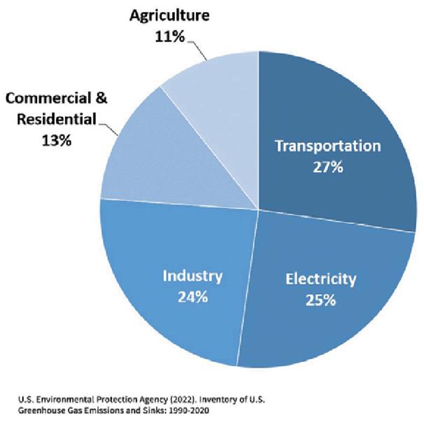
ThelargestshareisrepresentedbytheTransportationSector,whichcoversalljourneysbyroad, rail,waterandair.Thissectorgenerated29%ofUSGHGin2019.OfthetotalGHGemittedfromthis sector,58%ofthemaregeneratedfromthefossilfuelsburntforlight-dutyvehicles(ie,cars, pickuptrucks,sportutilityvehicles(SUVs),vans,andminivans),withanadditional24%from mediumandheavydutytrucks Thegoodnewsonthisfrontisthatthereareactionsthatcanbe takenfromaplanningperspectivetodrivethesenumbersdown.Theserangefromsite-specific actions,suchasprovidingadequateinfrastructureforchargingelectricvehicles,tobigger-picture andphilosophicalchanges,suchasplanningforfuturegrowththatislessautomobiledependentby incentivizingnewgrowththatoccursintheformofcompact,walkable,mixed-usecommunitiesthat provideavarietyofhousingchoicesandofferserviceswithineasywalkingdistanceof neighborhoods.
WhiletheTransportationsectoristheonemostdirectlyrelatedtoplanning,intermsofthe possibilitytoreduceGHGemissions,itisnottheonlyone.Tothatpoint,thefollowingarepotential mitigationstrategiesthatcommunitiescanimplementthatmorebroadlycanreduceGHG emissions:
• Increasingtheuseofrenewableenergyandaccesstoalternativefuels.
• Providingoptionsforactivetransportation
• Designingenergy-efficientbuildingsandresilientinfrastructure.
• Protectingandenhancingnaturalsystemsandwaterresources
• Maximizingco-benefitsofecosystemservicesandgreeninfrastructuresolutions.
• Purchasingclimate-friendlyproducts
• Educatingthepubliconsocioeconomicandpublichealthimpactsofclimatechange.
TheenergysuppliertothevastmajorityofEastonpropertiesistheEastonUtilitiesCommission (EUC).Broadlyspeaking,EUCispursuinganumberofsustainablegoalsandobjectives.Notably,this includestheir“SustainabilityCampus”Ofnotetothetopicofrenewableenergy,theEUC SustainabilityCampusincludesasolararray,describedbyEUCas:
Perhaps the biggest effort to offset greenhouse gas emissions was the installation of the 2MW solar field at Easton’s Sustainability Campus located adjacent to the wastewater treatment facility. The array generates more than enough electricity to power the entire treatment plant. On average, 20% of the electricity generated by the panels is fed back onto the local electric grid. Commissioned in 2017, the nearly 10-acre site was constructed for a total of $4 million. Through a grant by Maryland Department of the Environment, 75% of the construction costs were covered, making Easton Utilities’ total investment $1 million. This partnership allowed the project to be both cost and environmentally effective, benefiting the community by avoiding almost 1,672 metric tons of CO₂e emissions per year
TheTownshouldcontinuetosupportEUC’ssustainabilityandrenewableenergyinitiatives.Beyond that,wecanandshouldexploreoptionsforadditionalsolararrays Inthecontextofagrowingtown likeEaston,thiscanbeachallengesincearrayscanconsumelargeamountsofland.However,there maybeopportunitiestoco-locatepanelsontheroofsoflargebuildingsorinlargesurfaceparking lots.
Therisksposedbyclimatechangeincluderisingsealevelsandstormsurges,heatstress,extreme precipitation,inlandandcoastalflooding,drought,increasedaridity,waterscarcity,andair pollution,allofwhichwillhavenegativeimpactsonanindividual’shealth,livelihoods,andassets,as
wellasthecommunity'seconomyandecosystems.Adaptationstrategiesareessentialtoreducing vulnerabilitytoboththelikelyeveryday,aswellasthemoreextremeordangerous,outcomesof climatechange
ThefollowingflowchartdepictsthemultipleimpactsofclimatechangeonTransportation,the consequencesofthoseimpacts,andsomeadaptationstrategiesthatcanbeemployed(bothto reduceimpactsandtoreduceconsequences):
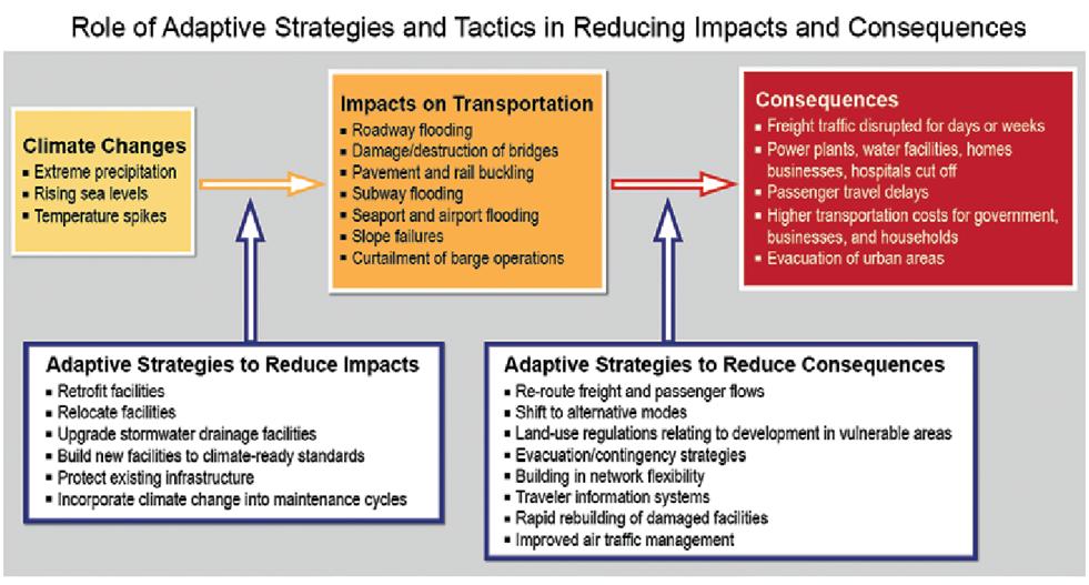
TheareawhereadaptationpoliciescanmostdirectlybeimpactedbyComprehensivePlanningisthe generalareaoflanduse.Thisisespeciallythecasewhencontemplatingfuturegrowthareas. Preventingfuturedevelopmentfromoccurringinvulnerablelocations,suchasalongwaterways,in floodplains,ornon-tidalwetlands,isaneasyproactiveapproachtoclimatechangeadaptation Itis coincidentallyconsistentwiththeessenceofthisPlan.Thisisimportantbecauseasthepreviously referencedPASReportnotes,comprehensivelanduseplanningthatanticipateslikelyclimate impactscanaccomplishthefollowingcommunity-widegoals:
• Encouragingcoordinatedtransportationandhousinginvestments,sothatpeoplecanafford toliveinsafeconditionswithtransportationchoiceincaseofemergency.
• Promotinggreeninfrastructureandsoundwatershedmanagement,whichcanreduce stormwaterrunoff,mitigatetheurbanheatislandeffect,andimprovepublichealth.
• Rehabilitatingwetlandriparianorestuarinehabitatsthatprovidenaturalecosystem services,suchasfloodprotection.
• Reducingthelong-termcostofdevelopmentbybuildinginareasthatarelessvulnerableto climateimpactsandcosts.
Impactscanalsobemadeattheindividualbuildinglevel.Forexample,increasedfrequencyand severityofheatwavesposeadditionalrisksforoccupantsofhomeswithoutcoolingmethods.Very youngchildren,theelderly(whorepresentahighpercentageofEaston’spopulation),andthose withinfirmitiesaremostsusceptibletoheatstrokesandotherhealthrisksassociatedwithextreme heat High-performancegreenbuildingscanhavebothmitigationandadaptationco-benefits
Adaptationpracticesareideallyimplementedatthetimeofconstruction,butmitigationtoexisting buildingscanoccurintheformofretrofittingexistinghomesandbuildingswithadditionssuchas greenroofsorsunshading,waterstoragespace,andsmartventilation
Finally,itisimportanttonotethatalthoughtherearespecificactionsthatacommunitymaypursue intherealmofclimateadaptation,monitoringandevaluationofadaptationpoliciesandactionscan bechallengingforanumberofreasons.ThePlanningforClimateMitigationandAdaptationPAS Report,liststhefollowingcautionswithregardstomonitoringadaptation:
TheaspectofsustainabilitythatismostdirectlyrelevanttoaComprehensivePlan,andwhichis addressedthroughoutthisPlan,isthatofthebuiltenvironment Thisincludesplanning-related areassuchasencouragingmoreenergyefficientbuildings,tofundamentalprinciplesoflanduse planningsuchasprescribingafuturedevelopmentpatternthatismoresustainablethanthatwhich hasoccurredinthelasthalf-centuryorso.
Withregardstofuturedevelopmentpatterns,themeasureofsuccesswilloverwhelminglycome fromwhathappensinourFutureGrowthArea.AccommodatingmoregrowthintheformofInfill andRedevelopmentoftheexistingTownboundarieswillhelpachievethisgoal,butgiventhenature ofthistypeofdevelopment,thestagehasessentiallyalreadybeenset
Infill/Redevelopmentwillbemoresustainableinthatsuchdevelopmentisgenerallymore accommodatingofactivemodesoftransportationandisclosertotheshoppingandservicesthat residentsneed,thusfacilitatingsuchactivetransportation.However,barringafundamental(and verylarge)changeinthescopeandnatureofdensityofdevelopmentinthevicinityofDowntown, anddespitestrongpublicsupportforfocusingfuturegrowthonthisaspect,thereisalimittohow muchcanbeaccommodatedinthismannerEventually,andlikelysoonerratherthanlater,the overwhelmingmajorityofgrowthwilloccurinwhatarenow“greenfields”inourFutureGrowth Area.ImprovingsustainabilityofthedevelopmentoftheseareaswilllargelydictateEaston’soverall success(orlackthereof)inimprovingthesustainabilityoftheTownasawhole
Theelementsthatwillleadtoamoresustainableformofdevelopmentinthefuturearecovered throughoutthisPlan,sotheywillnotbediscussedindetailhere InparticulartheImplementation Chapterdiscussesindetailrecommendedoptionsforachievingthisgoal.Forthepurposesofthis chapter,simplylistingtheoptionstoimprovethesustainabilityoffuturegreenfielddevelopment willsuffice,andtheyinclude:
• Permitting/encouraging/requiringmixed-usedevelopment
• Facilitatingresidentialdevelopmentatahigherdensityandwithawidervarietyofhousing options
• Maximizingconnectivitytootherfuturedevelopment.
• Providing,wherepossible,connectivitytoexistingdevelopment
• Facilitatingandaccommodatingactivemodesoftransportation.
TheUNFoodandAgriculturalOrganization(FAO)describesasustainablefoodsystemas“afood systemthatdeliversfoodsecurityandnutritionforallinsuchawaythattheeconomic,socialand environmentalbasestogeneratefoodsecurityandnutritionforfuturegenerationsarenot compromised Thismeansthat:
• Itisprofitablethroughout(economicsustainability);
• Ithasbroad-basedbenefitsforsociety(socialsustainability);and
• Ithasapositiveorneutralimpactonthenaturalenvironment(environmental sustainability)”
AsagrowingandvibrantTown,thereislittleactualagriculturalactivityoccurringwithinthe corporatelimitsofEaston However,landthatisannexedintoTownisoftenagriculturaland sometimesremainsassuchforseveralyears.Thereiscertainlynothingwrongwiththispracticeof allowingfarmingasessentiallyatemporaryorinterimuseuntillandowner/developermotivation and/ormarketforcesdictatethatitistimeforthepropertytodevelop Furthermore,theTown envisionstheTalbotCountysideofourGrowthBoundarytoconsistoffarmsandforestsand supportstheireffortstopermanentlypreservetheseareas
Onasmallerscale,withintheTownlimitssustainable foodsystemscanbesupportedthroughgardens These canbelocatedonprivatepropertyfortheuseand enjoymentoftheresidentoftheproperty,orinthe formofacommunitygarden.Onesuchcommunity gardenexistsintheEastEndNeighborhoodofEaston, justoutsideofDowntown(seepicturebelow) This optionisespeciallyappropriateinthemoredensely developedsectionsofTownwherelandmaybetoo scarceforindividualprivategardens.
Beyondtheseenvironmentalandgeneralqualityoflifeaspectsofsustainability,futuredevelopment patternshaveevenmorediversesustainabilityimplications.Onesuchaspectisthefinancial sustainabilityofsuchdevelopment,andultimatelytheTownasawhole Inshort,therearea
multitudeofpotentialdevelopmentscenariospossibleforanygivenparceloflandintheGrowth Area.SomewillresultinsignificantrevenuefortheTown,butmightalsoimposelargenewcosts. Othersmaynotcostthatmuchtoserve,butmayalsocontributeverylittleinthewayofnew revenue.Fromtheperspectiveoffinancialsustainability,developmentthatjustifiesitscostby providinganetpositivefiscalimpacttotheTownoughttobeprioritizedoverthatwhichwill ultimatelybeanetdrainonTownresources.
Althoughitcancertainlyvarydependingonthelocalgovernment’staxstructureandpolicies, residentialdevelopmentingeneral,andspecificallysingle-use,low-densityresidential development,tendstocostlocalgovernmentsmoretoservethanitproducesinnewtaxrevenue Ontheotherhand,mixed-useandnon-residentialdevelopmentcanbecashflowpositiveforlocal governments.Onewaytoview/measuresuchimpactsisonavalueperacre(VPA)basis.An assessmentofEaston’sVPAwasconductedin2024bythefirmUrban3anditsresultsare summarizedintheLandUseChapterofthisPlan.
In2024,thePlanning/EconomicDevelopmentFirmUrban3modelledthefiscalimpactsoflanduses ontheEasternShoreingeneral,andtheninTalbotCountyspecifically.ThebasisofUrban3’s methodologyinvolvesexamining“valueperacre”fortheareabeinganalyzed Thefollowingis excerptedfromtheUrban3studyforTalbotCounty.
HighlightsfromtheUrban3studyforTalbotCountyinclude:
● Mixeduseprojectsprovidethehighestpropertyvalueperacre
● Higherdensitydevelopmentissignificantlymoreproductivethanlessdenselanduses
● UnderstandinghowdifferentlandusesaffectpropertytaxrevenuewillallowEastonto makeinformeddevelopmentdecisionsthatmaximizerevenueproductivitythatcanthenbe usedinprovidingservicessuchaspublicsafetyandcontinuingeconomicdevelopment
● UsingtheValuePerAcre(VPA)modelallowscommunitiestolinkfiscallyproductiveareas withtheirassociatedlandusetypes
● Usingamoderatetohighproductivitysampledevelopment,suchasmixedusecommercial ormissingmiddlehousingtypes,asanexampleforhowtobuildinthefuturecanguide communityconversation,vision,processes,andfutureregulations
● Urban3hasseenthatfundingforinfrastructuresystems(roads,sewer,water,stormwater)is insufficientincoveringthelifecycleexpensesforthesesystems.Certainusersofthese systemsmaynotbepayingforthetruecostofwhatittakestoservethem(meaningother usersaresubsidizingthem).Adjustfees,withgeographyinmind,toadequatelycoverthe costsofoperationandmaintenanceorencourageinfilldevelopmentratherthanservicing newareas.
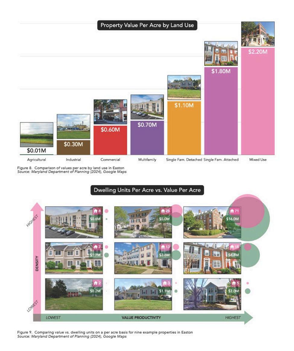
Urban3modelinghashelpedtheTownevaluatewhereexistingdevelopmentpatternsprovide strongreturnonpublicinvestment.Compact,walkableneighborhoodsgeneratemoretaxrevenue
peracreandrequirelessinfrastructuretosupportthanlow-densityfringedevelopment.This analysissupportslandusedecisionsthatpromotelong-termsustainability.
AsEastongrows,thetowncanshapeitsdevelopmentandfinancialoutcomes.Urban3createdthree growthprojectionscenariosforPoplarHill,FourSeasons,andGannonRange,usingexistingland usevaluesandbuildingtypes(seeFigure14)appliedtositeplansfromEaston(Figure15)
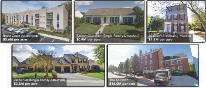
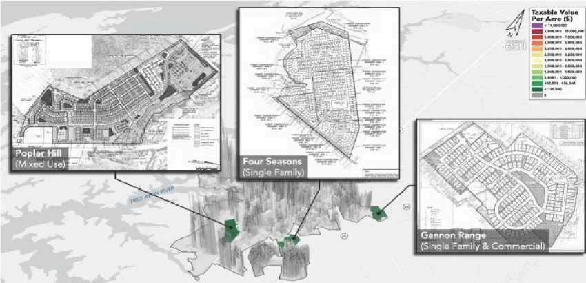
Figure15.ExamplesiteplansusedforprojectionsscenariosfortheTownofEastonSource: Maryland Department of Planning (2024), Google Maps
Figure16analyzestheFourSeasonssiteforpotentialsinglefamilyresidentialdevelopment, comparingattachedanddetachedbuildingtypes.Ifdevelopedassinglefamilyattachedunitslike thoseonJasperLane,thesite'staxablevaluecouldincreaseby743times Incontrast,traditional singlefamilydetachedhomeswouldyieldasmallerincrease.Buildingtypeanddevelopment patternshouldbeconsideredtomaximizepropertytaxrevenueforEaston
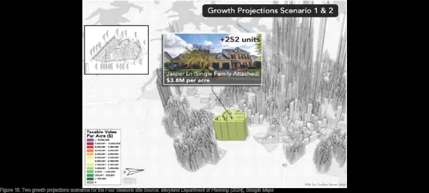
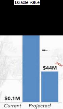
Figure17presentsasummaryofscenarioprojectionsforeachsite,includingdevelopmenttypeand potentialpropertytaxrevenueforEaston.AlthoughPoplarHill(nowownedbyTalbotCounty)may notdevelopasplanned,itsscenarioprovidesamodelforfuturemixed-usedevelopmentsinEaston
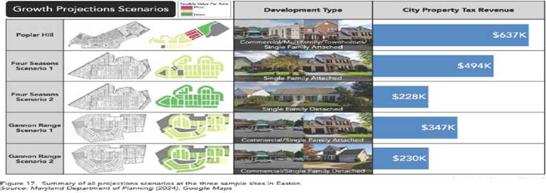
● HowcanValuePerAcre(VPA)beincreased?
o UnderstandCurrentRevenueandSpendingPatterns
▪ Urban3’sanalysisexamineshowlanduseisrelatedtoeconomiccashflowin theTownofEastonanditsoperationalcapacityIdentifyingtheeffectsof variouslandusesonpropertytaxrevenueprovidesinformationfor developmentdecisionsaimedatincreasingrevenueproductivitythat supportspublicservicessuchassafetyandeconomicinitiatives
o RepeatWhatWorks
▪ ReviewingtheValuePerAcre(VPA)modelenablescommunitiestolink fiscallyproductiveareaswithcertainlandusetypes.Usingexamplesfrom moderatelytohighlyproductivedevelopments,suchasmixed-use commercialpropertiesormissingmiddlehousing,mayserveasreference pointsforfuturecommunityplanning,discussions,procedures,and regulations.
o IncreaseDensityIncrementally
▪ PermittinghigherdensityoffersastraightforwardmethodtoincreaseVPA, asraisingthevaluerelativetoacreageresultsinahighervalueperacre. Addingoneortwostoriestostructurescansignificantlyaffectproductivity Typically,densitymodificationsareimplementedthroughchangesinland developmentregulations,whichmaypromptdifferingopinions
▪ AsEastondevelopsfurther,thetownwillhavetheopportunitytodecideon thedirectionofgrowthanditsfinancialoutcomes UtilizingUrban3's analysis,Eastoncanidentifyandapplyproductivelandusepatternsand buildingtypes
● HowcanVPAbeincreasedandcostsreduced?
o UnderstandtheCosttoMaintainInfrastructureSystems
▪ Urban3’sobservationsindicatethatfundingforinfrastructuresystems (includingroads,sewer,water,andstormwater)oftendoesnotcovertheir fulllifecycleexpenses.
▪ Someusersmightnotbebearingtheentirecostrequiredfortheirservices, resultingincross-subsidization
▪ Adjustingfeesgeographicallymayhelpensurecoverageofoperationand maintenancecostsorpromoteinfilldevelopmentoverexpansionintonew areas.
TheEasternShoreLandConservancymaintainsaresourcepageontheworkofUrban3onthe EasternShore. ForadditionalinformationontheUrban3Analysis,pleaseseeESLC’swebsiteat: https://wwweslcorg/urban3/
Althoughitcancertainlyvarydependingonthelocalgovernment’staxstructureandpolicies, residentialdevelopmentingeneral,andspecificallysingle-use,low-densityresidential development,tendstocostlocalgovernmentsmoretoservethanitproducesinnewtaxrevenue. Ontheotherhand,mixed-useandnon-residentialdevelopmentcanbecashflowpositiveforlocal governments Onewaytoview/measuresuchimpactsisonavalueperacre(VPA)basis An assessmentofEaston’sVPAwasconductedin2024bythefirmUrban3anditsresultsare summarizedintheLandUseChapterofthisPlan
Anotheraspectofsustainabilitythatcanbeaffectedbydevelopmentpatternsisthatof social/culturalequity.Socialequityindevelopmentpatternsreferstoensuringfairandjust distributionofresources,opportunities,andpublicservicesacrossallsegmentsofacommunityIt involvesaddressingdisparitiesinaccesstothingslikehousing,healthcare,education, transportation,andemployment,aimingtopreventcertaingroupsfrombeingleftbehind
Considerationofsocialequityinplanningandfuturelandusepatternsisimportantforanumberof reasons,includingthefollowing:
• ReducedPovertyandInequality-Byaddressingtherootcausesofpovertyandinequality, socialequitycontributestoamorejustandprosperouscommunity.
• IncreasedSocialCohesion-Whenpeoplefeelthattheyhaveequalopportunitiesandaccess toresources,itfostersasenseofcommunityandbelonging.
• GreaterResilience-Equitablecommunitiesarebetterequippedtowithstandeconomicand environmentalshocks.
• SustainableDevelopment-SocialEquityisanessentialcomponentofsustainable development,ensuringthatprogressbenefitsallmembersofsociety,bothpresentand future
TheTownofEastoniscommittedtoensuringequitableaccesstotransportationfacilitiesand servicesforallresidents,regardlessofrace,color,nationalorigin,sex,income,orabilityThis commitmentisformalizedthroughtheTitleVIAnnualUpdateAccomplishmentReport,preparedby theDepartmentofPublicWorksandsubmittedtotheMayoreachyearThereportoutlinesactions takentocomplywiththeTitleVIoftheCivilRightsActof1964andtheCivilRightsRestorationAct of1987(P.L.100.259).
TheTown’sTitleVIpolicyaffirmsthatnopersonshallbeexcludedfromparticipationin,deniedthe benefitsof,orsubjectedtodiscriminationunderanyprogramoractivityreceivingfederalfinancial assistance ThereportincludesapolicystatementreaffirmingtheTown’sdedicationto non-discriminationanditsresponsibilitytoupholdthesestandardsacrossalldepartments, programs,andprojects
EnvironmentaljusticeprinciplesareembeddedintotheTown’smultimodaltransportation planning.Inparticular:
● TheBicycleandPedestrianMasterPlanweightedsocialequityfactors includingproximity tolow-incomehousing,accesstosocialservices,andconnectivitytotransit when evaluatingandprioritizingprojects
● Transitplanningemphasizesimprovedserviceforhistoricallyunderservedand transportation-disadvantagedpopulations
Throughthesepractices,Eastonensuresthatinvestmentsininfrastructurecontributetomore equitablemobility,safety,andaccessforallresidents
Goal #1: Address Climate Change through Mitigation and Adaptation.
Objectives:
● Reducegreenhousegasemissionsthroughcompact,walkable,mixed-usedevelopment
● ExpandrenewableenergyproductionandEVcharginginfrastructure.
● Improvebuildingenergyefficiencyandresilientdesign
● Protectandrestorenaturalsystemsthatactascarbonsinks.
● Preventdevelopmentinvulnerableareassuchasfloodplainsandwetlands
● Integrategreeninfrastructuretomanagestormwaterandheatimpacts.
● Retrofitbuildingstowithstandextremeweatherandreduceenergydemand
Goal #2: Promote a Sustainable Built Environment.
Objectives:
● Focusgrowthininfillandredevelopmentareasbeforegreenfields.
● Requiremixed-use,higher-densityneighborhoodswithdiversehousingtypes.
● Ensurenewgrowthisconnectedtoexistingdevelopmentandsupportsactive transportation
● Maximizestreetandtrailconnectivityinallnewprojects.
● UtilizetheTown’sForestConservationAccountandothersourcestoaddlandscapingalong heavilytraveledcorridors.
Goal #3: Support Food Security.
Objectives:
● PreservefarmlandandforestswithintheGrowthBoundary
● Allowinterimagriculturaluseonundevelopedannexedland.
● Encourageprivateandcommunitygardens,especiallyindenserneighborhoods
Goal #4: Ensure Financial Sustainability of Development.
Objectives:
● Prioritizeprojectswithapositivenetfiscalimpact.
● Promotelanduseswithhighvalueperacre(VPA)
● Encouragemixed-useandhigher-densitydevelopmenttoreduceservicecosts.
● Adjustfeestoreflectthetruecostofinfrastructureandservices
Goal #5: Advance Social Sustainability and Equity.
Objectives:
● Ensureequitableaccesstohousing,transportation,andpublicservices.
● ApplyTitleVIandenvironmentaljusticeprinciplestoallTownprograms
● Prioritizeinfrastructureinvestmentsinunderservedneighborhoods.
● Includeequityconsiderationsinprojectevaluationandplanning
“If
you don’t know where you are going, you might end up someplace else.”
Casey Stengel
TheMunicipalGrowthElement(MGE)outlineshowtheTownofEastonwillmanagefuturephysical expansioninacoordinated,efficient,andsustainablemanner.Itidentifiesareasforpotential annexationanddevelopment,explainsrationaleandreasoningbehindfuturegrowth,andassesses whethertheTownhasthenecessaryinfrastructureandservicestosupportthatgrowth.
ThischapterfulfillstherequirementsofMaryland’sHouseBill1141(2006),whichamendedthe LandUseArticletorequireacomprehensivegrowthstrategyaspartofeverymunicipalplan.It integratesEaston’sgrowthmanagementapproachwiththebroaderlandusepoliciessetforthin thisComprehensivePlan
TheMarylandLandUseArticlerequiresthiselementtoaddressthefollowing:
1 Areasanticipatedforfuturegrowthoutsidethecurrentmunicipallimits;
2. HistoricgrowthpatternsoftheTown;
3 DevelopmentcapacitywithincurrentTownboundaries,includinginfillandredevelopment potential;
4 Additionallandneededtoaccommodateprojecteddemandatdensitiesalignedwith long-termpolicy;
5 Infrastructureandservicesrequiredtosupportgrowthinnewareas,including:
a. Publicschools(meetingState-ratedcapacitystandards);
b Libraries;
c. Publicsafetyandemergencymedicalservices;
d Waterandsewersystems;
e. Stormwatermanagement(toprotectwaterquality);
f. Recreationalfacilities;
6 Anticipatedfinancingstrategiesforpublicservicesandinfrastructure;
7. Ruralbuffersandtransitionzones;
8 ImpactsonservicesandinfrastructurethattheTownmayneedtoprovideforgrowthjust outsideitsboundaries;
9 Measurestoprotectsensitiveenvironmentalareasaffectedbynewdevelopment;
10.Populationgrowthprojections;and
11 AvisionforEaston’sfuturecharacterandhowlong-termgrowthpolicysupportsit
This2025updatebuildsontheMunicipalGrowthElementintroducedin2010,incorporatingnew data,insightsfromrecentgrowthpatterns,andtheupdatedprioritiesofthisPlan
ThepaceofEaston’sgrowthhasbeenarecurringpointofdebateinthelastthreeComprehensive Planupdates Historically,theTownreliedonthefreemarkettodeterminegrowth However,inthe 2010Plan,thePlanningCommissionconcludedthatcontinuedgrowthatthehistoricrateofaround 3%annuallythreatenedtheTown’straditionalcharacterandmadeithardertoaddresskey challengessuchastrafficcongestionandenvironmentalimpacts.ThatPlanestablishedapreferred targetof1%annualgrowth,supportedbyanAnnexationPolicydesignedtolimitrapidexpansion throughcontrolledPriorityGrowthAreas.
Thise2026Plan2025Planrenewstakesadifferentthisapproach Itis,however,importanttoclarify whatisintendedbytheestablishmentofa1%annualgrowthrateasourtarget. ThisPlanis not concernedwithlimitinggrowthsolelyforthesakeofdoingso. Rather,werecognizethatthereisan amountorpaceofgrowthatwhichthenegativecharacteristicsofdevelopmentbecome difficult-to-impossibletokeepupwith. 1%maynotnecessarilyrepresentthatthreshold,butitcan serveasacheckpointsuchthatif/whenweexceedsuchgrowth,wecanandshouldassess howwell weare(orarenot)managingthosenegativecharacteristics,suchastraffic,environmentalimpacts, infrastructureandservicecapacitiesandthelike Afteradecadeinwhichannualgrowthaveraged only0.7%,thePlannolongersetsafixed“preferred”rate.Instead,it Thiscallsforactive monitoringtoensuregrowthoccursatapacethatTowninfrastructureandservicescan
accommodatewithoutunduestrain,andmayincluderecommendationsforpursuingwhat,ifany, measuresarenecessarytoslowfuturegrowth..
Fromitsincorporationin1710through1917,Eastonremainedasmall,compacttown.By1965,it hadgrownprimarilyinanorth–southdirectionbutwasstillboundedbyUSRoute50andthefuture MDRoute322(EastonParkway) Expansionbeyondtheselimitsbeganin1966andacceleratedin the1970safterfullannexationoftheParkway/Route50corridor.
Mapsillustratethisoutwardspread,buttheydon’tshowanequallyimportantchange theshiftin developmentform.Likemuchofthecountry,Eastonmovedawayfromwalkable,compact, traditionalpatternstowardamoresuburban,auto-orientedlayout Reversingthistrendhasbeena consistentfocusofrecentComprehensivePlansandremainsacentralobjectiveofthisPlan,as discussedfurtherinthePlaceElement.AmapshowingEaston’scorporatelimitsatvariouspointsin timewasshownin31,XX,ExistingLandUsePatterns
WhileannexationsexpandedtheTown’sfootprint(seeAppendix3foralistofannexations),the formofdevelopmentshiftedfromwalkable,compactpatternstomoresuburban,auto-oriented layouts.RecentComprehensivePlanshavesoughttoreversethistrend,emphasizingareturnto traditional,connectedurbanforms
PopulationgrowthtrendsaredetailedinthePlanBackgroundChapter.WiththeGrowthBoundary inplace,theTown’sultimatepopulationislargelypredictable,assumingcurrentpatternsofdensity, residential/non-residentialbalance,andhouseholdsize.BasedontheadoptedGrowthBoundary andcurrentassumptionsaboutdensity,landusemix,andhouseholdsize(2.19personsper household,2020Census),Easton’sultimatebuildoutcapacityisestimatedat17,594dwellingunits, or38,531residents.
Thetimingofreachingthatcapacitydependsongrowthrates:
● At3%annually,(thefigureusedinthe2004Plan)buildoutwouldoccurinabout27years (2052)
● At1%annually,(thefigureidentified asapreferredtargetinthe2010Plan)buildoutwould occurinapproximately80years(2105)
● Ata1.75%rate,buildoutwouldtakecloserto45years(2070).
Thelikelypopulationgrowthratedependsonahostoffactors. However,itcanbeusefultolook backathistoricgrowthinordertolookforwardtoprojectsuchgrowth. Thefollowingtableand chartwerepreparedwiththeassistanceofGoogleSheets,usinggrowthintheTownfrom1960 through2020toprojectthefuturegrowthoftheTownthrough2050,usinglinearregression analysisprovidedviatheFORECASTfunctioninSheets Suchgrowthwouldcorrespondtoa112% annualgrowthrateoverthe30yearperiodfrom2020-2050,anda1.5%averageannualgrowth rateforthe90yearperiod(196-2050)
TheForecastfunctionpredictsafuturevaluebasedonexistingvaluesusinglinearregressionto projectfuturedatapointsalongalinethatbestfitsthehistoricaldata.Itcanbeusedtoforecast sales,planabudget,orpredictfuturetrendsorshort-termincreasesordecreases Linear forecastingissuitableforstableenvironmentswherepredictable,incrementalchangesoccur, whereasexponentialforecastingisbetterforrapidlyexpandingorcontractingtrendsdrivenby compoundingfactors. Linearregressionshouldbeusedcautiouslywhenusedforpopulation projectionsbecausepopulationgrowthisoftenmorecomplex Still,whenlimitedtoashort-term projectionandwithsomanyunknownvariables(e.g.,whichdirectionandbyhowmuchinterest rateswillchange,theimpactofLakesideatTrappeontheEastonhousingmarket,theimpactofthe lastoftheBabyBoomergenerationreachingretirementage,etc),lookingtothepasttomake predictionsaboutfuturegrowthseemsreasonable. Further,theR-squaredvalueof0.973suggestsa formulathatisextremelyeffectiveatpredictingoutcomes
TheSheetsGROWTHfunctionissimilartoFORECASTwiththenotabledifferencethatitprojects exponentialgrowth It'susedforforecastingdatathatfollowsanacceleratingpattern,suchassales, population,orinvestmentgrowth,bycalculatingy-valuesforaspecifiedexponentialcurve. Using thisfunctiontoprojectEaston’sfuturegrowth,yieldsthefollowing:
Thismodelpredictsa1.6%averageannualgrowthrateforthefuture30yearperiod(vs.1.12%via thelinearmodel).
ThePlanningCommissionviews1.75%asthemaximumsustainablerateatthistime.Thisis consideredhighenoughtosupportcontinuedvitalitybutlowenoughtoavoidoverburdening infrastructure
ThisPlanproposesarevisiontothewayitusesgrowthrates.Afteradecadewheretheaverage annualgrowthratehasdroppedto07%,theconceptofaimingfora“targeted”or“preferred” growthrateforthePlanningperiodhasbeendropped. Instead,thedirectiverelativetoourGrowth Rateisnotsomuchanattempttolimit(orincrease)anyparticularrate,butrathertoconsistently monitortherate/amountofgrowthweareexperiencingsothatwhatevergrowththatdoesoccur,is ataratethatdoesnotoverlytaxtheTown’sinfrastructureandservices. We believethat,forthis Planningperiodatleast,thiscanbestbeaddressedbyadheringtoanAnnexationPolicythatdoes notallowforanexceedinglyhighrateofgrowth,whichwouldbeonecharacterizedassignificantly atvariancewiththe112%projectedgrowthforseveralyears Thiscanbemonitoredthrough observationofthenumberofdwellingunitsapprovedannually. Thismonitoringshouldbeakey characteristicofthePlanningCommission’sAnnualReportingresponsibilities Beyondreporting though,effectivegrowthmanagementrequiresanassessmentofthedata. Asustainedobserved significantdeviationfromthetargetedfromexpected targetedratesofgrowthof1%annuallymay necessitateactionstoeitherencourage(ifaprolongedperiodofslowornegativegrowthis observed)or limit(ifexpectedgrowthisobservedtohavebeenexceeded)futuregrowthfromthat pointintime ThisbecomesespeciallycriticalifobservationssuggestthatEaston’spopulationis,in fact,behavingmoreliketheexponential(GROWTH)modelasopposedtothe linear(FORECAST) model
Animportantaspecttoconsiderwhencontemplatingfuturegrowthratesisthenumberofunits approvedbutnotyetbuilt,sometimesreferredtoasthe“developmentpipeline” AsofMay12, 2025,thatnumberstoodat843. Whilethatbasictotalnumberisimportanttoknow(and, obviously,readilyobserved),whatismoredifficulttopredictiswhenthoseunitswillbebuilt, referredtoasthe“absorptionrate” Amyriadoffactorsinfluencetheabsorptionrate,including:the numberofdifferentprojectsrepresentedbythetotalnumberofunits,thetypesofunits,the demandforthoseunits,interestrates,pricepoints,,competitionintheregion,andsoon
Thepipelineandabsorptionrateareimportantbecausetheycanfurthersupportthepolicyto strictlylimitannexation,particularlyannexationforresidentialpurposes Thatisborneoutbythe
calculationofthenumberofdwellingunitsthatthehistoric1.12%expectedgrowthratewould yieldoverthe10yearplanningperiod. Thisnumberisapproximately875units. Thus,with843 unitsalreadyinthedevelopmentpipeline,assumingtheycouldbebuiltinthisplanningperiod(and notaccountingforfactorssuchastherelativedemandforcertainhousingtypes,locations,etc.),the housingthatwouldberequiredtocorrespondto112%annualgrowth canbecompletelymetby thebuildoutofexistingapprovedprojectsplusasmallhandfulofadditionalunits. Essentially,the pipelineinventoryissuchthatitcouldsupplythehousingassociatedwiththeprojectedgrowthof thenext10yearplanningperiod. Thisisevenmorelikelygiventhatwearetargetinga1%annual rateofgrowth.
Easton’scurrentboundariescontainenoughdevelopablelandtomeetmuchoftheprojected residentialandnonresidentialgrowthforthenext20years However,demand especiallyfor mixed-useandemployment-relatedspace mayeventuallyoutpacethiscapacity.Managinggrowth willrequireannexationsthatarecarefullyalignedwiththePlan’slandusevision,infrastructure capabilities,andfiscalpriorities.
ArecentrequirementforComprehensivePlansistoestimatethecapacityforresidential developmentwithinexistingTownboundaries.Thisanalysisconsidersthreecategories: undevelopedland,infillparcels,andsiteswithpotentialforredevelopment.
Tocompletethisassessment,severalassumptionswereapplied:
● Urbandensitybaseline:Futuredevelopmentisassumedtooccurathigherdensitiesthanin recentyears,withaminimumof35dwellingunitsperacre thethresholdfordesignation asaPriorityFundingArea(PFA).
● Stateguidance:MethodologyfollowstheMarylandDepartmentofPlanning’sModelsand GuidelinespublicationEstimatingResidentialDevelopmentCapacity.
● Localexperience:AssumptionsareinformedbyEaston’spastdevelopmentreview processes.
Thefollowingtabledetailsthestep-by-stepcalculationofestimatedresidentialdevelopment capacitywithincurrentTownlimits.
* Area 2 corresponds to the site of the Four Seasons project (252
Area 3 is the Poplar Hill property (now owned by Talbot County and assumes no future residential units.
Area 4 is Ashby Commons (Now essentially built out so assumes no new units).
Area 7 is the “Alvin Lapides Property” (Estimated 60 units).
8 is Easton Point (Estimated 332 units per Port Street Small Area Plan).
included in the AKRF Study)
NOTE:TheunitsforthePerduesitesandSafeway arebasedonapprovedprojects.
OurbestestimateisthatEastoncanaccommodateapproximately2,744additionaldwellingunits withinexistingTownlimits withoutannexingnewresidentialland(exceptforportionsofEaston PointnotedinArea8)
Thisdoesnotmeanall2,744unitswillnecessarilybebuiltbeforenewlandisneeded.Several factorswillreducetheactualyield:
● Environmentalconstraintsmaylimitdevelopmentonsomeparcels,eveniftheyappear suitableonpaper
● Unwillinglandownersmaychoosenottodevelopinthenearterm.
● Marketpressurescoulddrivetheneedtoopengrowthareasearlier,particularlyifrestricted supplyinflateshousingpricesandworsensEaston’saffordabilitychallenges.
WhilethecurrentPlanningperioddoesnotrequirenewannexationforresidentialgrowth,the Townmustremainpreparedtoexpandstrategicallywhencapacitywithintheboundarybecomes constrained.
The2,744-unitestimaterepresentsamodestincreasefromthe2,492unitsprojectedinthe2010 Plan Thegainisprimarilydueto:
● AddingEastonPoint(Area8)asaPriorityDevelopmentArea.
● Amorerefinedredevelopmentanalysis,incorporatingspecifichigh-potentialproperties ThisgainwaspartiallyoffsetbytheremovalofArea3(Hospital-ownedOxfordRoadsite)following itspurchasebyTalbotCounty
Atthetargetedgrowthrateof1.75%annually,theexistingcapacitycouldaccommodateroughly18 yearsofgrowth farexceedingthe516newunitsaddedbetween2010and2020 Thissuggests thattheexistingTownlimitsaresufficientforthenextdecade.
However,capacityestimatesaretheoretical Real-worldconstraints suchaslower-than-maximum densities,redevelopmentchallenges,andpoliticaloreconomicbarriers meantheactualbuildout maybelower.HousingaffordabilityinEastonisalreadystrained,andincreasingsupplyremainsa keystrategyforaddressingit
Additionally,thisanalysisdoesnotincludepotentialpolicy-drivenincreasesincapacity.For example,allowingmultifamilydevelopmentinGeneralCommercialandLimitedCommercialzones couldyieldupto1,240additionalunitsonthe155currentlyunimprovedacresinthosedistricts(at 8du/ac),excludingfurtherredevelopmentpotentialonimprovedparcels.
The2010ComprehensivePlanestimatedthatEastoncouldaccommodateroughly2,500new housingunitsthroughinfilldevelopmentandredevelopment growththatcouldoccurwithout annexingadditionalland.
Pursuingthisstrategyoffersmultiplebenefits:
● Preservesopenspacebyreducingpressuretoconvertgreenfields.
● Improvesmobilityforresidentswhodonotorcannotdrive,byplacingmorehousingnear servicesandtransit.
● Lowersinfrastructurecostssinceextendingserviceswithintownistypicallylessexpensive thanbuildingnewsystemsforoutlyingareas.
● Expandshousingvariety,especiallysmaller,lower-maintenanceunitsthatappealtosmaller householdsandlower-incomeresidents.
● Enhancesneighborhoodvitalitybyencouragingreinvestmentandaddingnewamenities
● Supportsenvironmentalgoalsthroughenergyconservationandreducedlandconsumption.
● AlignswithMarylandSmartGrowthpolicies,reinforcingsustainabledevelopmentwithin existingtownboundaries.
Whileinfillandredevelopmentbringclearbenefits,theymustbemanagedcarefully.Theseprojects aretypicallysurroundedbyexistingneighborhoodsandmustbedesignedtocomplementthem Thefollowingprinciplesshouldguideinfillandredevelopment:
● Ensurecompatiblehousingtypeswiththesurroundingneighborhood
● Incorporatetrafficcalmingmeasureswhereappropriate.
● Adoptdesignguidelinestopromotevisualandfunctionalcompatibility
● Maintainacontinuouspedestriannetworkforwalkability.
● Supportneighborhood-scalecommercialuses,whereappropriate,toprovidewalkable accesstobasicservices.
● Addressparkingcreatively,consideringnearbyon-streetspaces,publiclots,and shared-parkingarrangementsinsteadofrelyingsolelyonprivatelots.
DuringthepublicengagementprocessforthisPlanupdate,manyresidentsexpressedstrong supportforinfillandredevelopmentaspreferredgrowthstrategies Whilethisisconsistentwith sustainabilitygoals,thesupplyofvacantlandwithinthebuilt-upareasofEastonislimited.
Achievingsignificantnewgrowthsolelythroughinfillwouldrequirealevelofintensitythatcould fundamentallyalterthecharacterofestablishedneighborhoods.
Amorerealisticapproachisto:
● PromotetargetedinfillandredevelopmentinandaroundEaston’shistoriccore.
● Supportadaptivereuseofexistingbuildingswherefeasible
● Encouragedenser,walkabledevelopmentinsuitableinfillareasoutsidethehistoriccorebut withinthe2025TownBoundary.
Thisstrategybalancesgrowth,preservation,andcommunitycharacterwhilemaximizingEaston’s capacitytogrowwithoutunnecessaryoutwardexpansion.
Asnotedpreviously,Easton’slongstandingpolicyisthatmunicipalservices,includingwaterand sewer,areextendedonlytopropertieswithinthecorporatelimits Thispolicyencourages annexationpriortodevelopmentandreinforcesacompactgrowthpattern.TheTowndoesnot supportextensionofservicestodevelopmentintheCountyGrowthistooccurattheedgesof Eastoninacontiguousfashion,coordinatedwithinfrastructurecapacityandconsistentwith communitycharacter
TheareabetweentheApril2004TownboundaryandtheestablishedGrowthBoundarybecame Easton’sdesignatedFutureGrowthArea.The2004Plandividedthisareaintothreesequential prioritylevelsforannexation,rangingfromnear-termtolong-range
The2010Planretainedthisthree-tieredsystem:
● Priority1–BoundaryRefinementAreas:MostlyalreadydevelopedunderTalbotCounty jurisdiction,suitableforannexationtocorrectboundaryirregularities
● Priority2–IntermediateGrowthAreasand
● Priority3–Long-RangeGrowthAreas:Notexpectedtobeneededfordevelopmentduring thatplanningperiod
MuchoftheBoundaryRefinementAreawasalreadybuiltoutunderCountyzoningandseptic systemregulations.AnnexationoftheseareashasgenerallybeendrivenbythedesireforTown waterorsewerservice,withlimitedpotentialfornewdevelopmentexceptforredevelopmentor moderateintensification Althoughthe2010Planmapshowedabout1,200acresinthiscategory, muchofitwasnotactuallyavailablefornewgrowth.
Inplaceofthetieredpriorityframework,thisPlanadoptsAnnexationPoliciesthatevaluate proposalsbasedonmeritratherthanpresetclassifications.Thisapproachallowsformoreflexible, needs-baseddecision-making
WhileAnnexationisnotviewedasnecessaryduringthePlanningPeriod,thoseAnnexation proposalsthataresubmittedwillbeassessedonwhetherthey:
● FillageographicorinfrastructuregapintheTownboundary.
● Canbeefficientlyservedwithwater,sewer,andotherpublicservices
● Addressidentifiedneedsforlanduse,housing,orpublicfacilitiesasoutlinedinthisPlan.
● Alignwiththecharacter,scale,andinfrastructurepatternofadjacentneighborhoods
● Providebenefitsthatoutweighpotentialnegativeimpacts(e.g.,traffic,demandonservices, etc)
Thispolicy-drivenapproachmaintainsgrowthmanagementobjectiveswhileallowingtheTownto respondtochangingconditionsandemergingopportunities.
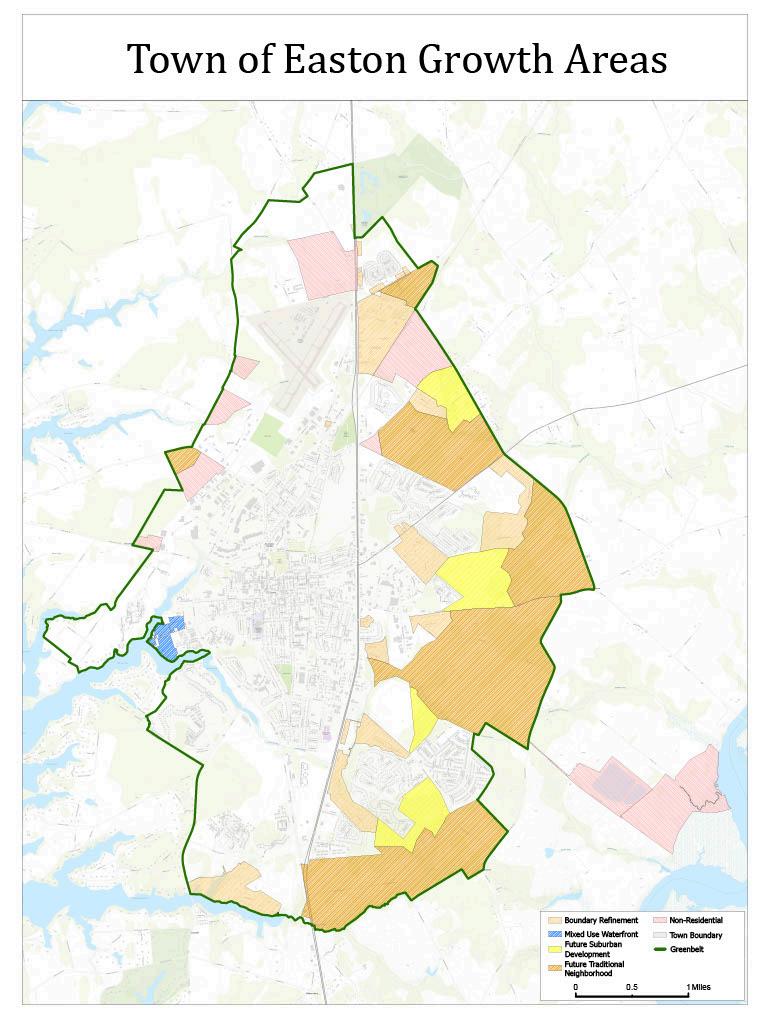
AsmentionedintheLandUseElement,thisPlanproposesoneadjustmenttotheGrowthBoundary, tobringtheTown’sWastewaterTreatmentPlanwithintheGrowthBoundary,ratherthaninthe Greenbelt(orbeyond) SuchanactionwouldfacilitateanAnnexationinthefuture,bringinga Town-ownedfacilitywithinTownlimits. Thishasadvantagesfromanadministrationstandpoint. It alsopotentiallyopensupadditionalavenuesforStatefundinginthefuture,totheextentthatsuch findingisrestrictedtobeingspentwithinPriorityFundingAreas.
Easton’sgrowthpoliciesaredesignedtocomplementTalbotCounty’seffortstopreserve agriculturalland,protectwaterresources,andguidegrowthtoappropriatelocations TheTownand Countywillcontinuetocollaborateonsharedplanningtools,greenbeltpreservationstrategies,and infrastructurecoordinationtopreventsprawlandleapfrogdevelopment.
Growthmustalignwithinfrastructurecapacityandpublicinvestmentplanning TheTownwilluse annexationagreementstosecuredeveloper-fundedinfrastructurewhereneeded,andwill coordinatewithEastonUtilities,theMDE,andotheragenciestoensureadequatefacilitiesfornew development.Futureannexationsmustdemonstratereadinessandfiscalviability.
WiththeadoptionoftheUrbanGrowthBoundaryinthe2004Plan reaffirmedinthe2010 Plan thequestionofhowmuchlandisavailablefordevelopmentisnolongeropen-ended. Regardlessofmarketdemand,theTownnowhasafinite,fixedsupplyoflandforfuturegrowth However,becausethisPlanlooksforwardovera30-yearhorizon,itisimportanttoassesswhether thatsupplywillbeexhaustedwithintheplanningperiodorwhethergrowthareaswillremain availableattheendofthattimeframe Todoso,weapplyaprocesssimilartotheanalysisusedto estimatedevelopmentpotentialwithinthecurrentTownboundaries,usingthesameassumptions andmethodologytoprojectbuild-outconditionsinthedesignatedGrowthAreas
Todoso,anexercisesimilartothatperformedtoassessthedevelopmentpotentialoflandwithin theexistingTownboundarywillbeconductedasfollows:
Total acreage of Future Growth Area = 3,880 acres
Less acreage already developed and/or non-residential – 1,300
= 2,580 acres x 3.5 du/ac x 0.75 (underbuild factor) = 6,773 du’s
ThisexerciseindicatesthattheGrowthAreahasthepotentialtoaccommodate6,773new residentialunits.Thisinformationcanbecombinedwithothercalculationsalreadymadetogiveus moreusefulinformation,suchas:
WithouttheconfinementoftheGrowthBoundary,ifwegrowevenatthemaximumtargeted175% averageannualcompoundrate,in2070,Eastonwould,allotherthingsbeingequal,havereached approximatelythe17,594dwellingunitsrepresentingourresidentialbuild-outcapacity.Atthe 112%wehavegrownatonanannualbasisforthepast60years,itwilltakeapproximately72 yearstoreachthisbuilt-outstate. Forthepurposesofthestatutoryrequirementofprojectinga ten-yearbuild-outcapacity,Eastoncertainlyhasnoissuesinthisregard
Thissectionwasfirstintroducedinthe2010ComprehensivePlantoaddresstheprojectedimpacts ofgrowthonabroadrangeofpublicservicesandinfrastructure.InearlierPlans,manyofthese topicswerecoveredundertheCommunityFacilitiesandServiceselement,whileothers typically managedattheCountylevel werenotaddressedatall Beginningwiththe2010update,theTown
incorporatedtheseareasintoitsplanningframework,evaluatinghowanticipatedgrowthwillaffect keyservices.ThisPlancontinuesthatapproach,updatingeachsubsectionwithcurrentdata,trends, andpolicyconsiderations
Public Schools
PublicschoolsinTalbotCountyarefundedandadministeredbytheCountygovernment.TheTown ofEastonplaystwokeyrolesinthissystem:
● PopulationSource–AstheCounty’smajorpopulationcenter,Eastongeneratesasubstantial shareofthestudentpopulation
● FacilityHost–ThreeoftheCounty’spublicschools,plustheBoardofEducation’smain offices,arelocatedwithintheTown
AsdescribedinSection7.EofthisPlan,althoughtheTowndoesnotoperateschools,itworks closelywiththeCountytoshareupdateddemographicdataforuseinpreparingtheAnnual EducationalFacilitiesMasterPlan(EFMP).
Capacity Outlook:
TheEFMPprojectsthattheCountyschoolsystemcanaccommodateanticipatedgrowthinEaston overthenextdecade,thoughcapacitywillbetightatthemiddleandhighschoollevels.Thenewly constructedelementaryschoolwillalsorequireeitheraphysicaladditionorredistrictingtomeet demand Unexpectedsurgesinpopulationcouldcreateadditionalstrain,dependingonthenatureof residentialgrowth.
Development Mix:
Mostresidentialprojectsinthedevelopmentpipelineareeitherhigh-endorage-restricted communities:
● Age-restrictedhousinggenerateslittletonopublicschoolenrollment
● High-endhousingmayhavechildren,butmanyattendprivateschools.
Asof2022,171%ofTalbotCounty’sK–12students(about932students)areenrolledinprivate schools.Thissignificantlyreducespublicschoolutilization;however,aneconomicdownturncould shiftmanyofthesestudentsintothepublicsystem,increasingdemand
Historic Enrollment Trends:
Between2000and2020,Easton’spopulationgrewfrom11,708to17,101 againof5,393 people whilepublicschoolenrollmentincreasedbyonly180students(from2,892to3,072) Basedonthisratio,theprojectedpopulationgrowthfrombuild-outwithinthe2023Town boundaries(anadditional6,752people)wouldyieldroughly225newstudentsinpublicschools.
Demographic Factors:
OnefactorthatcouldalterthispatternisthechangingcompositionoftheTown’spopulation.The EFMPnotesagrowingHispanicstudentpopulation,parallelingEaston’sbroaderdemographic shift from35%Hispanicin2000to144%in2020 whichmayinfluencefutureenrollment patterns.
Libraries
ThestateoflibraryserviceinTalbotCountyis describedinSection7FofthisPlan Intermsof futureneeds,theAmericanPlanningAssociationsuggestsaratioof0.6to0.65squarefeetoflibrary spacepercapita. AccordingtotheMDDepartmentofAssessmentandTaxation,theTCFLis28,174 squarefeetinsize. Thiswouldsatisfytheneedsofapopulationofapproximately45,000. Thatis wellinexcessofeventheultimatebuild-outpopulationforEaston,andwhilethelibraryserves residentsbeyondEaston,theyalsohavebranchfacilitiesbeyondEaston Thereclearlyareno growth-relatedimplicationsforlibraryservicesduringthisPlanningPeriod.
AsdescribedinSection7H,publicsafetyinEastonencompassespolice,fireprotection,and emergencymedicalservices.Thissubsectionfocusesonserviceadequacy,anticipatedneeds,and facilityrequirements
The1997ComprehensivePlanreferencedtheInternationalCityManagersAssociation(ICMA) standardof1.75policepersonnelper1,000residents.The2004PlanupdatetheTownusedthe InternationalCenterforPreventionofCrimebenchmark 336officersper1,000 residents reflectingtheU.S.nationalaverage.
With48swornofficersservingapopulationofapproximately17,101(2020),Eastonfallsbetween thetworeferencedguidelines. TheICPCsuggestsweneed57officers,whiletheICMApegsthe numberat30 Localconditionsjustifystaffingatthehigherendoftherange:
● Eastonfunctionsasaregionalhubforemployment,commerce,andentertainment,servinga populationwellbeyondTownresidents.
● Residentsvaluestrongcommunitypolicing.
● SeasonaltrafficbetweenOceanCityandtheBaltimore–Washingtonarea,alongwithmodest localtourism,createshigherservicedemands.
Givencurrenttrends,existingstaffinglevelsareconsideredadequate,andgradualincreases proportionaltogrowthshouldmeetfutureneeds Fire Protection
TheEastonVolunteerFireDepartmentservestheTownandsurroundingareas,fundedjointlyby theTownandCountyIn2002,ambulanceservicetransitionedtoTalbotCounty,whichnow operatesthecountywideemergencymedicalsystem.FireCodeenforcementistheresponsibilityof theMarylandStateFireMarshal
GrowthinandaroundEastonpromptedtheconstructionofanewfiresubstationonMatthewstown Road,providingbetteraccesstoUSRoute50andproximitytonewdevelopment Uncontrolled growth eitherinpaceorlocation couldrequiretransitioningfromanall-volunteertoapaid department,withbothfiscalandcommunityimpacts,includinglikelytaxincreases
Emergency Medical Services
AdvancedLifeSupport(ALS)operatescountywidewithvolunteerandpaidstaff,fundedbythe County,fundraising,anddonations While24-hourserviceisavailable,ALSfacesequipmentfunding challengesduetoincreasingcallvolumes.
Evaluatingfuturepublicsafetyneedsinvolvesmorethanpopulationforecasts Keyfactorsinclude:
● Trafficvolumes:HighertrafficonUSRoute50increasesaccidentratesandcanslow emergencyresponse
● Developmentpatterns:Traditional,well-connectedstreetnetworksreduceresponsetimes andtheneedforadditionalsubstations,whilesuburbanpatternswithlimitedaccesspoints canstrainresources.
TheadequacyofEaston’swaterandwastewatersystemsthrough2040isdetailedinthe CommunityFacilitiesandServicesandWaterResourceselementsofthisPlan.Forthepurposesof thisMunicipalGrowthElement,thefocusisoncapacityandimprovementsrequiredtoservefuture growthidentifiedinthisPlan.
Growth Projections and Service Demand
TheFutureLandAreaNeededtoSatisfyDemandanalysisprojectsapproximately:
● 6,800newdwellingunitsingrowthareasoutsidetheTownlimits(6,773calculated)
● 3,100newunitswithinexistingTownlimits(3,083calculated)
● 727existingunitsoutsidetheTownbutwithintheGrowthArea Servicecapacityplanningmustaccountforbothresidentialandnon-residentialdemand,which variesgreatlybyusetype Whileresidentialwaterandwastewaterusageispredictable, non-residentialuses especiallyindustrialoperations cancreatedisproportionatedemand.
TheEastonWastewaterTreatmentFacility(WWTF),broughtonlinein2007,hasatreatment capacityof4.0milliongallonsperday(MGD).AsofDecember31,2023,averagedailyflowwas 2463MGD
● ProjectedCapacityLimit:Ata1.75%annualgrowthrate,theWWTFisprojectedtoexceed capacityin2054
● ExpansionCapability:TheWWTFsitehassufficientspaceforcapacityexpansion, anticipatedtobemodestinscale.
● HospitalImpact:Theplannedregionalhospitalwilladd0.101MGDinPhase1andupto0.2 MGDatfullbuildout approximately5%ofcurrentcapacity.Thiscouldadvancetheneed forexpansionbytwoyears(from2051to2049)
● TheEastonUtilitiesTariffrequiresthatallnewconnectionstothesystempayawaterand wastewatercapitalcharge Inadditiontothecapitalcharge, developersarerequiredto constructcertainsectionsofdistributionandcollectionsystems.
TheWastewaterMasterPlan(updateinprogress)confirmsnutrientremovalcapacityisadequateto supportplanned1.75%growththrough2045andbeyond.However,thefollowingcomponentswill requireupgradesonceflowsexceed40MGD:
● Headworks
● FlowEqualization
● SecondaryClarifiers
● UVDisinfection
● Post-Aeration
Eastoniscurrentlyservedbyfiveproductionwells,withanewwellplannedforFY25,providinga totalproductioncapacityof40MGD(includingredundancyforthelargestwelloutofservice)
● CurrentUse:Averagedailyflowis1.90MGD,withamaximumdaydemandof3.36MGD.
● FutureNeeds:TheWaterMasterPlanprojectstheneedforanewwellin2043andanew 1.0million-gallonstoragetankin2051toservetheGrowthArea.
● CIPCoordination:TheCapitalImprovementPlanisupdatedannuallytoprioritizeandfund systemupgrades.
BoththeWaterMasterPlanandWastewaterMasterPlanarebeingupdatedtoensureEaston UtilitiescanmeetserviceneedsforthefullGrowthArea.Strategiccapitalimprovements, coordinatedwithgrowthpatterns,willensuretheTowncan:
● Maintainservicereliability
● Meetnutrientreductionrequirements
● Servenewresidential,commercial,andinstitutionaldevelopmentefficiently ChartssummarizingplannedwaterandwastewatercapitalprojectsareincludedinAppendix5.
Afulldiscussionofstormwatermanagementpolicies,regulations,andwatershedimpactsis providedintheWaterResourcesElementofthisPlan.Asinmanyoldercommunities,Easton’s stormwaterinfrastructurereflectsawiderangeofstandards,dependingontheerainwhich differentareasweredeveloped.Earlierdevelopmentoftenoccurredbeforemodernstormwater standardswereinplace,resultingininconsistentperformanceacrosstheTown
Today,alldevelopmentinEastonmustcomplywiththeStormwaterManagementOrdinance,which regulatesboththequantityandqualityofrunoff
● QuantityStandard:Post-developmentrunoffmaynotexceedpre-developmentlevels.
● QualityStandard:Eastonappliesthe10%pollutantreductionstandardfromthe ChesapeakeBayCriticalAreaProgramtoalllandwithinTownlimits,notjustCriticalArea properties
TheTownalsoencouragesinnovative,low-impactdevelopmentpractices.Bio-retention,rain gardens,andothergreeninfrastructureareincreasinglyrequiredinmajorprojects,suchasLowe’s andWatersideVillage.
Thegreateststormwaterchallengesoccurinlong-establishedneighborhoodsbuiltbeforecurrent regulations.Intheseareas,theTownpursuesretrofitprojectstoimproveperformanceandwater qualityTheseeffortsarecarriedoutthrough:
● PrivateDevelopmentRequirements–Requiringadjacentredevelopmentprojectstoaddress existingstormwaterissues.
● Town-LedRetrofits–Initiatingcapitalprojectstoupgradesystemsinolderneighborhoods.
● PartnershipProjects–WorkingwithenvironmentalorganizationsandTalbotCountyto securegrantfundingfortargetedimprovements.
ArecentexampleistheTanyardBranchRetrofitProject,whichincludesconstructionofasediment pondontheTown-ownedRTCParkparcel.Thisprojectwill:
● ImprovewaterqualityenteringtheTredAvonRiverheadwaters
● Reducelocalizedfloodinginhistoricallyflood-proneneighborhoods
StormwatermanagementisnotexpectedtobealimitingfactorforEaston’sfuturegrowth, provided:
1 NewdevelopmentcontinuestomeetStateandlocalstandards
2. Redevelopmentincorporatesmodernstormwatertechniquesandiscoordinatedwithadjacent newdevelopment
3. Strategicretrofitsinolderareasareimplementedasfundingbecomesavailable
Throughcontinuedregulatoryenforcement,proactiveretrofitting,andintergovernmental collaboration,Eastoncanensurestormwatersystemssupportbothwaterqualityandquantitygoals andplannedgrowth.
AfullassessmentofEaston’sparksystemisprovidedintheParksandRecreationElementofthis Plan IntheMunicipalGrowthElement,thefocusisonparklandneedsgeneratedbyfuture growth bothwithintheexistingTownboundariesandintheeventualbuild-outoftheGrowth Area.
TheStateofMarylandrecommends30acresofparklandper1,000residents,withhalfunder municipalownership Basedonthisstandard:
● Current(2020Census)Population–17,101→513acresneeded(257acresTown-owned)
● Build-outofExistingTownLimits→716acresneeded(358acresTown-owned)
● FullBuild-outIncludingGrowthArea→1,178acresneeded(589acresTown-owned)
AsofFebruary14,2024,Eastoncontainsanestimated91045acresofparksandopenspace(plus HydePark,ElliottRoadApartments,andVickersPark).Thismeetscurrentneedsandwillremain sufficienttoaccommodatethebuild-outofexistingTownboundarieswithoutacquiringadditional parkland.
Fullbuild-outoftheFutureGrowthAreawouldrequireapproximately268additionalacresofparks andopenspace.TheTown’ssubdivisionregulations requiringdeveloperstoprovide35%ofsite
areaascommonopenspaceand1,200squarefeetperdwellingunitforparks/playgrounds are expectedtomeetthisneed.The9,400newunitsprojectedatultimatebuild-outwouldgenerate approximately259acresofdedicatedparkspace,nearlysatisfyingtheState’sstandardforthe entiregrowthhorizon.
WhileEastonmeets andisprojectedtocontinuemeeting Stateparklandstandards,certain factorsmayrequireadditionalplanningandlanddedication:
● GeographicDistribution:Aregional-scaleparkisneededontheeastsideofTowntoensure equitableaccess.
● SpecializedFacilities:Demandfororganizedsportsfieldsexceedswhattheper-capita standardassumes,asEastonservesastheCountyseatandaregionalrecreationhub.
EastonalsobenefitsfromtwolargerecreationalsitesjustoutsidetheGrowthBoundary,which functionallyserveTownresidents:
● SethStateDemonstrationForest–124.5acres
● HogNeckGolfCourse–2759acres
Theseassets,thoughnotwithinTownlimits,helpmeetbroaderrecreationalneedsandrelievesome futuredemandpressures
Easton’scurrentanalysisshowsthatexistingandplannedinfrastructurecanaccommodatethe projected2,500newhomeswithincurrentTownboundaries,aswellasportionsoftheFuture GrowthAreasidentifiedforpotentialannexation.Allnewdevelopmentrequiresbasic infrastructure,including:
● Waterandsewerservice
● Stormwatermanagement
● Roadsandtransportationaccess
● Parksandplaygrounds
Consistentwithcurrentpractice,theTownshouldrequiredeveloperstofundtheinfrastructure necessarytoservetheirprojects.Additionallong-termneedstosupportplannedgrowthinclude:
● Watersystemupgrades
● Wastewatertreatmentcapacityexpansion
● Policestaffingincreases
● Neworexpandedparksandrecreationfacilities
● Publicsafetyenhancements,includingnewequipment,personnel,andfacilities
StateandCountyfinancialassistanceshouldbepursuedtoupgradeinfrastructurein redevelopmentareas.ProgramssuchasCommunityLegacycansupportstreetandstreetscape improvements,whileNeighborhoodConservationprogramscanhelpmodernizeinfrastructureto facilitatereinvestment.CooperativeuseofProgramOpenSpaceandtheMarylandMunicipalParks Programcanoffsetparkacquisitioncostsbeyondthosesecuredthroughthedevelopmentreview process
Theannexationprocess beingadiscretionarylegislativeaction providesanopportunityto securelandforparks,publicfacilities,andothercommunityamenitiesthroughannexation agreements Thisshouldremainastandardpracticeforstrategicallyexpandingcommunityassets alongsidegrowth.
BothTalbotCountyandtheTownofEastonhaveenactedImpactFeeOrdinancessinceadoptionof the2004ComprehensivePlan Easton’sfeesfundparksandrecreation,municipalfacilities, transportation,police,andfireservicesneededfornewdevelopment.TalbotCounty’sfeesapply countywideandsupportlibrary,parksandrecreation,publicschool,communitycollege,general government,andtransportationservices Maintainingthesemechanismsensuresthatthecostof growthisbornebynewdevelopmentratherthanexistingtaxpayers.
BoththeTownofEastonComprehensivePlanandtheTalbotCountyComprehensivePlandesignate aGrowthAreasurroundingtheTown’smunicipalboundaries,withagreenbeltlocatedimmediately outsidethisareaontheCountyside.ThegreenbeltworksinconcertwiththeUrbanGrowth BoundarytopreventoutwardsprawlintoruralpartsoftheCounty
AnUrbanGrowthBoundaryfunctionsastheoppositeofsprawl establishingaclear,permanent edgebetweenthebuiltenvironmentandthecountryside Atfullbuild-out,thisboundarywillcreate adistincttransitionbetween“inTown”and“inthecountry,”avoidingablurred,low-density suburbanfringe.
TheTownpartnerswithTalbotCountyandwithagriculturalandforestpreservationorganizations tomaintainandprotectthegreenbelt.Asignificantportionofthislandisalreadypreserved,as shownonMap8:ProtectedLandsinandAroundEaston’sGreenbelt
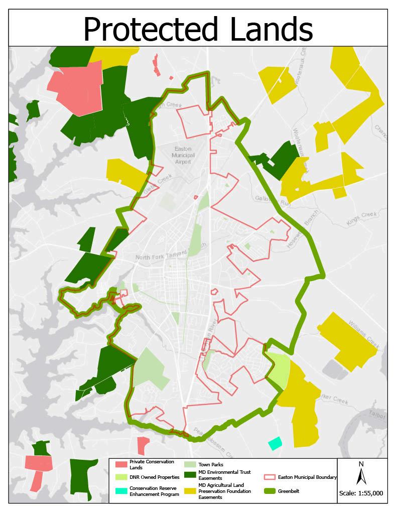
Currently,Eastondoesnotprovidemunicipalservicesorinfrastructureoutsideitscorporate boundaries,withtheexceptionoffireandrescueservices.Theseservicesaredeliveredbya volunteerorganizationratherthantheTownitself
Asnotedearlierinthischapter,theformandpaceofdevelopmentdirectlyinfluencethedemands placedonfireandrescueresources Uncontrolled,low-densitygrowthgreatlyincreasesthe likelihoodthatEastonwouldneedtotransitionfromavolunteerfiredepartmenttoapaid service bringingsignificantfinancialandstaffingimplications.Incontrast,managedgrowthina compact,traditional,urban-scalepatternhelpspreservetheviabilityofavolunteer-basedsystem
In2012,theMarylandGeneralAssemblyenactedtheSustainableGrowthandAgricultural PreservationAct,requiringalljurisdictionstomapexistingandplannedsewerserviceareasand classifythemintoservicetiers
ForEaston,thisprocesswasstraightforward.TheTownCounciladopteditsTierMapinDecember 2012,designatingthreecategories:
● TierI–Existingsewerservice.
● TierII–PlannedforsewerservicewithintheMunicipalorGrowthArea.
● TierIIA–MunicipalorGrowthArea,notyetincludedintheCountyWaterandSewerMaster Plan
ThisTierMapwasincorporatedintotheComprehensivePlanin2016andisshownasMap10 below:
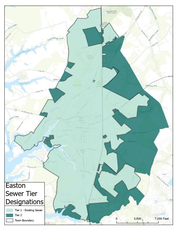
TheTownofEastonprioritizesidentifyingsensitiveenvironmentalareasearlyinthedevelopment reviewprocesssotheycanbeavoided,protected,orenhanced Thesamestandardswillapplyto anyfuturedevelopmentwithintheGrowthArea.
● StreamsandBuffers–A100-footbufferisrequiredfromperennialstreams(50feetfor intermittentstreams)toprotectwaterqualityandhabitat.
● 100-YearFloodplain–WhileEastoncontainsfewfloodplainareas,theyareregulatedunder theTown’sFloodplainOrdinance,whichisconsistentwithboththeNationalModel FloodplainOrdinanceandtheNationalFloodInsuranceProgram Giventhelimitedsizeof theseareas,mostsitesallowdevelopmenttobelocatedoutsidethefloodplain.
● HabitatsofThreatenedandEndangeredSpecies–Theseareasareidentifiedasearlyas possibleinthereviewprocess.Siteplansareadjustedasneededtoprovidemaximum protection.ForpropertiesoutsidethecurrentTownlimits,identificationshouldoccur duringtheannexationstage
● SteepSlopes–RareinEaston.MostoccurwithinstreambuffersortheChesapeakeBay CriticalAreaandarealreadyprotected
● AgriculturalandForestLandsforResourceProtectionorConservation–Whileagricultureis notprohibitedinEaston,growthwillinevitablyconvertmuchoftheagriculturallandinthe GrowthAreatodevelopment.TheTowndoesnotactivelypreservefarmland,butdoes maintainastrongcommitmenttoforestconservation
Easton’sForestConservationProgramensuresvaluableforestresourcesareprotected,particularly thosealongstreamsorassociatedwithnon-tidalwetlands.Regulationsnowrequiresuchprotected lands whetherforest,wetland,orbuffer nottobelocatedonindividualprivatelots Instead,they mustbeplacedinseparateparcelsheldbytheTown,ahomeowners’association,oraconservation entity
IndevelopingtheGrowthArea,theTownwillmaintainthesepoliciesandlookforopportunitiesto expandprotectedforestlands AnotableexampleistheSethDemonstrationForest,partofEaston’s Greenbelt.ItbordersEastonClubEastandundevelopedlandtothenorth,whereafuture large-scaleparkisenvisioned ForestConservationareasinEastonClubEastconnectdirectlyto
SethForest,creatinganexpandedandmorecohesiveforestarea.Futureenhancementscould includeadditionalforestpreservation,treeplanting,andamenitiessuchasawoodlandgarden.
TheImplementationChapterofthisPlansummarizestheGrowthStrategyfor2025-2035andnotes thatitwilllargelybeaccomplishedthrough,generallyspeaking,sixmajorinitiativesthatare envisionedtoadvancetheVisionofthisPlan. ThisMunicipalGrowthElementseemsanappropriate placetofirst summarizetheoverallfactorsshapingourevolving growthmanagementstrategy
IncontemplatingagrowthmanagementstrategyforEaston,itisnecessarytofirstconsiderwhat thecommunityfeelsisundesirablewiththecurrentstateofgrowthanddevelopment Indoingso,it isapparentthattherearemanygreataspectstotheTown.Whatdrivesthedesireforagrowth managementstrategyistherecognitionoftrendscontrarytotheseaspects.Theseinclude:
● Developmentthatistoowasteful.Densityintheolder,historicpartsofEastonistwoto threetimesasdenseasthatfoundinmanyofthesubdivisionsofthelast40to50yearsand yet,theseolderhistoricpartsofEastonareconsistentlyidentifiedthroughpublicinputas thebestpartsofEaston.
● Commercialdevelopmentthatistooubiquitous Thatistosay,itisvirtually indistinguishablefromthatinanyothercommunity.
● GrowththatisspreadingoutwardtooquicklyThereisconcernamongstmanyresidents thatEastonisspreadingtoofar,toofast.Muchofthisproblemrelatestothefirstpoint above Thatis,sincedensityissolowinEaston,moreandmorelandisnecessaryto accommodateevenaconstantrateofgrowth.Tothispoint,publicinputintheearlystages ofthisPlan’spreparationindicatedaclearandstrongpreferenceforaccommodatingthe majorityofgrowthduringthisPlanningcycleintheformofInfill,Redevelopment,and AdaptiveReuseratherthanonnewlyannexedFarmlandandForests.
● Theconstructionofsingle-usesubdivisionsratherthanneighborhoods Again,thiscausesa needformorelandandalsonecessitatesincreasedautomobileusage.
Withthisasthebackdrop,thefollowingGrowthManagementStrategyforEastonisproposed Itis identicaltothatwhichwasfirstproposedinthe2010Plan,withonenotableadditionanda modification
ThefirststepinEaston’sproposedGrowthManagementStrategyisdesignedtocontainthe seeminglyendlessoutwardexpansionoftheTown Thisisaccomplishedthroughtheestablishment ofanUrbanGrowthBoundary(UGB),asfirstimplementedinthe2004PlanUpdate.AnUGBis essentially“alineinthesand.”OntheTownsideofthisline,town-scaledevelopmentwilloccur.On theothersideoftheline,developmentismuchlessdense InEastonandTalbotCounty’scase,the differencewillbeevenmoredramaticbecausebothjurisdictionsareproposingthattheUGBbe boundedontheCountysideofthelinebyagreenbelt Thiswouldbeagreenringsurroundingthe futureultimateTownlimitsconsistingofforests,wetlands,andfarms.Thisgreenbeltwouldbecome atoppriorityareaforlandpreservationprogramsandinitiativesattheCountylevel.
TheUGBisdepictedontheGrowthAreaandFutureLandUseMaps.Ithasbeensizedtocorrespond tothesizeofacommunitythatweultimatelyfeelcomfortablewithintermsoftheabilityofEaston tomaintainitscharmandqualityoflife Whatthistranslatesintointermsoffuturepopulations dependsonthedensityofdevelopmentwithintheUGBaswellashowsuccessfulweareintermsof encouragingrevitalizationandinfillredevelopment Whatthispopulationisorwhenweachieveit islessimportantthanensuringthatwhenwegetthere,Eastonisthekindofplacethatcurrentand futureresidentswillbeproudtocallhome
ThelocationoftheUGBwasbaseduponconsultationwiththeTalbotCountyPlanningCommission, currentdevelopmenttrends,anticipatedtrendsduetogoalsandobjectivessuggestedinthisPlan andlogicalboundariesestablishedbypropertylines,roadwaysandnaturalfeatures Thuswhileitis viewedasapermanentdividinglinedemarcatingurbanandruraldevelopment,thepreciselocation oftheUGBwillbeexaminedagainin10yearsaspartofthenextComprehensivePlanupdate,justas ithasbeeninassociationwiththisPlanrevision.
This2010PlanUpdateproposednochangestotheUGBandthisUpdatedoesnotaswell Ithas,in fact,remainedunchangedsincetheadoptionofthe2004Planwithoneexception.Thatwasthe expansionofthegrowtharea(andthustheGrowthBoundaryandGreenBelt)toaccommodatethe siteoftheproposedfutureHospitalandtheTalbotCommunityCenter.
WhiletheestablishmentofanUrbanGrowthBoundaryandGreenBeltcanachievetheobjectiveof containingtheoutwardexpansionoftheTown’surbanfootprint,thecharacterofEastonofthe futurecouldstillbeawidevarietyofthings,dependingonwhatisallowedorencouragedtohappen onthein-TownsideoftheboundaryFillinginthegrowthareawithsingle-familydetachedhomesat the2.0du/acorsodensityofmanyofthesubdivisionsbuiltsince1980wouldbeaninefficient,
unsustainableuseofthisland.Ontheotherhand,dramaticallyincreasingdensityinthenameof greatersustainabilitycouldalsoleadtoafutureEastonthatwouldbeoutoftheexpresseddesired characterforourcommunity
PerhapsthemostreadilyapparentdifferencebetweentheDowntownareathatsomanypeoplelove andhopetoseereplicatedandthenewer“suburban”scaledevelopmentthathasoccurredmore recently,isthedensityofthesetwotypesofdevelopment.Accomplishingthefirststepinthe GrowthManagementStrategy,establishinganUrbanGrowthBoundary,willaccomplishlittleif withinitsbordersdevelopmentcontinuesatascopeandscalesuchaswehaveseenformuchofthe last30-50years
ThemosttellingindictmentofEaston’srecentdensitiesisthefactthatinandofthemselves,they wouldnotevencomeclosetoqualifyingasPriorityFundingAreasunderthetermsoftheState’s guidelines.Theminimumdensitynecessarytoqualifyassuchis3.5dwellingunitsperacre(net). Easton’smorerecentdevelopmentshaveadensityofjustlessthan2dwellingunitsperacre. This hasanumberofimplications,includingpromotingthesuburbanstyleofdevelopmentthatis generallydisparagedthroughoutthisPlan,representingawastefuluseofland,andinefficiently servingtheresultinghomeswithvariousutilitiesandpublicservices
Inordertoreversethistrend,apreviousPlanproposedthecreationofanewzoningdistrictthat wouldbeassignedtoallfutureresidentialareas ThePlanevensuggestedthedevelopment standardsforthisnewdistrict.AsdescribedinapreviouschapterofthisPlan,thisnewTraditional NeighborhoodZoningDistrictwasproposedbutneveradoptedbytheTownCouncil.Instead, changesweremadetotheexistingR-10AandR-7AzoningdistrictsaswellastotheSubdivision Regulations,inanattempttogetsomeofthesuggestedchangesaddedtoourexistingdevelopment standards Inanefforttoincreasethelikelihoodthatfuturedevelopmentpatternsaremore traditionalandlesssuburban,theTNDconcepthasbeenreintroducedinthisPlanUpdate,as describedinthePlaceChapter
ThisconcepthasbeenarecurringthemethroughoutthisComprehensivePlan Itwasdiscussed extensivelyinthePlacechapterandtoucheduponinseveralotherplaces.Thekeyistoensurethat thisapproachistheeasiestoneunderwhichtodevelopandthatthemorerecentlycommonplace
suburbantypeofdevelopmentisthedifficultmethodthatwouldonlybeapprovedundertruly uniqueandextenuatingcircumstances.
Assumingthesechangesinfuturedevelopmentpatternscanbeachieved,onlypartoftheproblem willbeaddressed.Eastonwillstillultimatelybeleftwithasuburban-stylemiddlesurroundinga trulytraditionallydevelopedcorewithaneo-traditionalstylecollectionofneighborhoodsonthe periphery.Undoubtedly,thebiggestchallengefacingtheTownisincreatingwaysto“retrofit”the suburban-stylesubdivisionstomakethemdenser,moreconnected,andmoremixeduse Thiswill bedifficultandultimatelymayneverbefullyachieved,butsomethingscanbedonetoimprovethe situation,andsomewereimplementedfollowingtheoriginalsuggestionforsuchchangesinthe 2004Plan.Theseinclude:
● Permitadditionstobemadetosingle-familyhousestocreategrannyflatsorduplexesasan outrightpermitteduse ThischangewasmadetotheOrdinance,butlittledevelopment activityofthistypehasoccurred.
● Effectivelynarrowstreetsbystripingorusingatexturedsurfacetocreatea pedestrian/bicyclelane.ThisconceptwasillustratedintheQualityCommunitySurveyand theresultswerestriking Theimageoftheexistingwidestreet(inthiscase,Corbin Parkway)receiveda-1.7rating.Thecomputer-simulatedimagewithatexturedbikelaneon bothsidesofthestreetreceiveda+25rating Thishasnotbeenaccomplished,although the concepthasbeendiscussedforpossibleimplementationatanotherlocation.Furthermore, overthecourseofthepastyear,theTown’sEngineeringDepartmenthasbegunstriping someofourmajorin-Townroadstobetterdefineparkingandtrafficlanesandto“calm” traffic.AuroraStreetandBrookletsAvenueserveastwoexampleswherethishasbeen accomplished
● Permitmoreneighborhoodscalecommercialusesbyspecialexceptioninresidentialzoning districts.Thishasrecentlybeenaccomplishedforoffices,whichareallowedbySpecial ExceptionintheR-10AandR-7AZoningDistricts Anumberofsupplementalstandards applyinordertoassurethattheneighborhoodisnotadverselyimpacted.Similarstandards canandshouldbeaddedforwhateverothercommercialusesmightbepermittedinthe suburban-stylesubdivisions(sincehopefullythenewerdevelopmentswillbemixed-usein naturetosomedegree).Therehasbeennofurtherprogressonthisrecommendation beyondthelimitedofficeusesthatareallowedasdiscussedabove
● Budgetforandstrategicallypurchasehousesastheybecomeavailableinordertodemolish themandredevelopthesitesforcivicorparkuse Thishasnotbeenaccomplishedoreven discussedsincethelastPlan.ThecurrenteconomicclimatemakesitdifficultfortheTownto considersuchinvestments,eventhoughmoreopportunitiesexisttopurchasesuch propertiesatreasonablepricesinsuchtimes.Goingforwardthisisaconceptthatshouldat leastbediscussedforpossibleimplementation.
● Allowforresidentialusesmoregenerallyincommercialzoningdistricts Whendiscussing theencouragementofmixeduses,thenotionofallowingcommercialusesinresidential developmentsisoftenraised However,itmaybemorefeasibletoaddresidentialusesto commercialareas.Allowingmulti-familyhousingincommercialzoningdistrictsseems particularlyappropriategiventworecentapartmentprojects,onBrantCourtandElliott Road,inashoppingcenter/industrialparkandalongacommercialcorridor,respectively.
● Exploreoptionsforthedevelopmentofvacantlandadjacentto“suburban”style subdivisions.InsuchscenariosrequiringaTNDstyledevelopmentmaynotalwaysbe
compatiblewiththeadjacentsuburbanformofdevelopment.Insuchlocations,something thatcanserveasatransitionbetweenthesetwotypesofdevelopmentisappropriate.They may,forexample,containsomeofthelowerunitcountmiddlehousingtypesbutnot, perhaps,thehigherunitcountsorattheoveralldensityweanticipateintheTNDformof development
ThestepsoutlinedabovewillgoalongwaytowardsmakingEastonabetterplacetolive The establishmentofaUGBwillcontaintheoutwardspreadofdevelopmentandtheestablishmentofa greenbeltintheCountyadjacenttothisUGBwilloffersomepermanencetothislimit Increasingthe densitywithintheTownwillimprovetheappearanceandfunctionofneighborhoodsaswellas decreasedevelopmentpressuresonotherareasinandaroundtheTown,notyetasreadytobe developed.Buildingneighborhoodsratherthansubdivisionsordevelopmentswilldramatically improvethelivabilityofEastonandwilldecreasetrafficbyofferingmoregoodsandserviceswithin walkingdistanceofwherepeoplelive Still,withallthesechanges,theTownwillnotgeneratea “senseofplace”feelingunlessimprovementsaremadetothewaythebuiltenvironmentlooks.
ThisissuewasdiscussedextensivelyinthePlacechapterofthisPlanandrecommendedDesign Principlesfor2025foundintheImplementationChapterisprimarilyintendedtoaddressthisissue, sothereislittleneedtorepeatthatmaterialhere
ThechallengeofthisComprehensivePlanistoensurethatthisefforttoachieveimproveddesign continues,infactadvancesevenmore,ratherthanretreats Inordertoaccomplishthis,the followingrecommendationsareoffered:
● Vigorouslyandconsistentlypromoteandrequirecompliancewiththe“DesignPrinciplesfor Easton”asdescribedintheCommunityCharacterElement
● Update/CreateDesignGuidelinesforvarioustypesofdevelopment(includingresidential).
● UtilizeForestConservationmoniesandoff-siteplantingstoenhancesparselylandscaped areasalongRoute50andtheEastonParkway.
● DevelopaTreeorUrbanForestryPlanoutliningareasproposedfornewtreeplantings, identifyingsites/locationssuitableasreceivingareasforoff-siteplantingthatdevelopers cannotaccommodateontheirproperties,andestablishingprioritiesandtoolsfor establishingthe“GreenRing”arounddowntowncalledforintheAKRFDowntownStudy.
● Accept(ifnotsolicit)annexationrequestsfromthosebusinesseslocatedonRoute50north ofthecurrentTownBoundaryandrequireconformancewiththeTown’sarchitectural, signage,andlandscapingrequirementsasaconditionofannexation,inordertoimprove thiskeyvisualgatewayintoTown.
Plan in Accordance with the Rate of Growth
TheissueofactivelyandpurposelycontrollingEaston’srateofgrowthhasbeenthesubjectofa greatdealofdebateforeachofthelastthreeComprehensivePlanUpdates,includingthisone HistoricallythePlanningCommissionandTownCouncilhaveelectedtoallowthefreemarketto determineEaston’sgrowthrate However,inthe2010PlanthePlanningCommissiondecidedthat indeedthedominantthemeofthatPlantoretainand/orreturntoanolderwayofdoingthingsin Eastonwasendangeredbyacontinuedrateofgrowthintherangethatwehadexperiencedinthe previous20yearsorso.Thefearwasthatat3%growth(ormore)developmentpressuresareso greatthatitbecomesmoreandmoredifficulttoachieveallthegoalsrelativetothetypeandformof developmentwewanttosee Furthermore,growthatsucharatemakessomeofourmost challengingproblems,suchasimprovingtrafficconditions,orlesseningourimpactonthe environment,evenmoredifficulttoachieve Asaresult,thePlanningCommissionandTownCouncil ultimatelyenactedaPlanwhichidentifiedapreferencefora1%annualrateofgrowth.
Theyalsorecognizedthatbymerelystatingthatwewanttoachievegrowthclosertoourlong-term averageof1%,absolutelynothingchangestomakethathappen.TheCommissionandTownCouncil discussedthisissueatgreatlengthandultimatelydecidedthat,forthatPlanningperiod,theissue shouldmostappropriatelybeaddressedbyadheringtoanAnnexationPolicythatdoesnotallowfor anexceedinglyhighrateofgrowth.ThePriorityGrowthAreaswereviewedassuitedtodothis.The onlypotentialshortcomingofthispolicyistherateatwhichinfill/build-outoccurs Forthisreason, thestaffwasdirectedtoexplorepoliciesandtoolswhichcouldachieveaspecifiedtargetedgrowth rate,intheeventthatgrowthgetsoutofcontrol
ThisPlanproposesrevisionstothispolicy.First,afteradecadewheretheaverageannualgrowth ratehasdroppedto07%,theconceptofaimingfora“targeted”or“preferred”growthrateforthe Planningperiodhasbeendropped.Instead,thedirectiverelativetoourGrowthRateisnotsomuch anattempttolimit(orincrease)anyparticularrate,butrathertoconsistentlymonitorthe rate/amountofgrowthweareexperiencingsothatwhatevergrowththatdoesoccur,isatarate thatdoesnotoverlytaxtheTown’sinfrastructureandservices. Sucharateofgrowthisbelievedto beinaccordancewiththelong-termcompoundrateof112%
TheoneadditiontotheTown’soverallgrowthmanagementpolicypresentedinthisupdateisto encouragemoresustainabledevelopmentpatterns.AsdiscussedintheSustainabilityChapter,this shouldbeconsideredbroadlytoincludeenvironmentalandeconomicsustainabilityItshouldalso benotedthatamoresustainableEastonhelpstoachieveamoresustainableTalbotCounty.For example,EastonfunctioningasagrowthcenterimprovesthechancesofTalbotCountysuccessfully avoidingsprawlingdevelopmentthroughoutunincorporatedpartsoftheCountyandenhancesthe likelihoodofsuccessfulagriculturalpreservation.
Environmentalsustainabilitycanbeadvancedbysuchactionsasprotectingandenhancingnatural featuresofproposeddevelopmentsitesandplanningfordevelopmentwithsea-levelriseinmind. Developmentwithamixofusesandwhichaccommodatesmultiplemodesoftransportationcan alsoenhanceenvironmentalsustainabilitybydecreasingvehiclemilestravelled,therebyimproving airquality(inadditiontotheoveralltransportationsystembenefits).
Economicsustainabilitycanbethoughtofinatleastacoupleofdifferentways.Oneisthecostto servenewdevelopment.Bythismeasure,infillandredevelopmentisclearlypreferredovernew “greenfield”developmentandnewgreenfielddevelopmentthatismorecompactandmore proximatetoexistingdevelopmentispreferredovermoresprawlingandisolatedprojects.
AnotherwaytoconsidereconomicsustainabilityisthenetfiscalbenefittotheTown Thatis,what formsortypesofdevelopmentprovidemoretotheTownintermsofnewrevenue,afterfactoringin thecosttoprovideservicestothosesamedevelopments?
Goal #1: Support Compact, Contiguous Growth that Strengthens Easton’s Form: Easton will grow in a manner that preserves its cohesive urban structure, avoiding scattered or inefficient development patterns.
Objectives:
● UseannexationtoclosegapsintheTownboundaryandreinforcelogicaldevelopment edges.
● Requirenewdevelopmenttoextendexistingstreetandutilitynetworksinacoordinated manner.
● PreventleapfrogdevelopmentthatbypassesundevelopedlandadjacenttotheTown.
Goal #2: Align Growth with Available and Planned Infrastructure: Growth will occur where infrastructure capacity is sufficient or can be provided efficiently, ensuring fiscal responsibility and service quality.
Objectives:
● Evaluateannexationanddevelopmentproposalsfortheirimpactonwater,sewer, stormwater,transportation,andpublicfacilities
● CoordinateannexationswiththeTown’sCapitalImprovementPlanandEastonUtilities’ investmentschedules.
● Requirethatnecessaryinfrastructurebeinplaceorfullyfundedpriortodevelopment approval
● Monitortherateofgrowthtominimizethelikelihoodofdevelopingmorerapidlythanthe Town’sinfrastructurecanaccommodate.
Goal #3: Leverage Annexation to Advance Public Benefit: Annexation will be used as a tool to secure public amenities and community enhancements alongside private development.
Objectives:
● Requireannexationagreementstodedicatelandforparks,greenways,trails,andpublic facilities.
● Negotiatefordevelopercontributionstowardinfrastructure,openspace,andcivicuses.
● EnsurenewdevelopmentreflectstheTown’sdesignstandardsandcommunitycharacter goals
Goal #4: Coordinate with Talbot County to Preserve Rural Lands and Guide Growth: Town and County will work together to maintain the Urban Growth Boundary, protect the surrounding greenbelt, and promote efficient land use.
Objectives:
● ContinuejointplanningeffortstomanagetheinterfacebetweenTownandCountylanduses.
● Supportagriculturalandforestlandpreservationtoolstomaintainadistinctedgebetween urbanandruralareas
● Aligngrowthmanagementpoliciestopreventsprawlandensurecoordinatedservice delivery.
“A plan without action is not a plan. It's a speech.”
~ T. Boone Pickens
Thequotecitedaboveallspeakstothenecessitytolinkplanningwithaction ThebulkofthisPlan framesthecontextofthepresentdayandoutlinesthePlanforthefuture.IfthePlanistoavoidthe fateof"sittingontheshelfandgatheringdust”,thisfinalchapteronImplementationwilllikelybe largelyresponsible.
This200+pagedocumentistheresultofyearsofextensivepublicinputandcontainsone Town-wideVision,dozensofgoals,hundredsofObjectives,andnumerousexplicitandimplicit additionalstrategiesandpolicyconsiderations.Thesheerbreadthandlengthofanycomprehensive plancanmakeitdifficulttoexecute;therefore,thisImplementationChapterfocusesonsixMajor Initiativestofocusonoverthenexttenyears,thattouchonmanyofthegoalsofthisplanandthatif achieved,willplaceusfirmlyontracktorealizethevisionforEastonin2035andbeyond
TheImplementationchapterturnsthevisionoftheComprehensivePlanintoaction.Itidentifies tools,responsibleparties,andtimeframesneededtomovefrompolicytopractice Implementation dependsonbothlong-termcommitmentandconsistentcoordinationacrosspublicandprivate stakeholders Thischapteroffersaframeworktoguidethatwork
ThroughoutthecourseofdevelopingthisPlan,thePlanningCommissionhasgrappledwiththe questionofwhattheappropriatestrategyshouldbeforaccommodatingtheexpectedgrowth duringthelifeofthisPlan.Therationalefortargeting1.75%growthratherthan1%haspreviously beendiscussed Inshort,thiswaspickedforanumberofreasonsincludinganexpectationthat thereissomedemandinourhousingmarketthatwillnaturallyresultinmoregrowth,that1.75% correspondstoaratethattheTowncancomfortablyhandleintermsofadministrativeprocessing, andtheTown’sinfrastructureismorethanadequatetoaccommodatesuchgrowth.
Anotheraspectofgrowthiswhereitwilloccur.ThisPlanhasdescribedtheoptionsforfuture growthintermsofinward-lookingoptions(i.e.,InfillDevelopment,Redevelopment,andAdaptive Reuse)orthemoreoutward-focusedoptionsofannexingmoreoftheFutureGrowthAreato accommodatefuture“Greenfield”developmentapplications.Thequestionofhowmuchofour growthshouldcomefromtheseoptionsduringthisPlanningperiodwasafocusofthepublicinput phase,whereanoverwhelmingpreferenceforInfill/Redevelopmentoptionswasexpressed.The MunicipalGrowthElementofthisPlanestimatesthat2,745additionalhousingunitscanbe constructedwithintheexistingTownlimitsofEaston.Thesewouldallbeconsideredofthe inward-focusedtypeofdevelopment.
Given this convergence of a preference for Infill/Redevelopment and the ability to accommodate the residential growth needs of this 10 year Planning cycle, the Planning Commission has determined that it is both possible and appropriate to not prioritize annexation of additional lands for residential development until at least the next Comprehensive Plan Update.
Thisstatementismadewithanumberofcaveats.One,itassumesthatdevelopmentinthepipeline proceedsthroughtoprojectcompletion Two,itassumesthattherewillbesufficientlandowners willingtodeveloporredeveloptheirpropertiestoaccommodatetheremainingprojectedgrowth forthenext10years.Finally,itdoesnotprecludenewannexation.Boundaryrefinement annexationsshouldbewelcomedatanytime,asshouldpropertyidentifiedinadoptedTownSmall AreaPlans(e.g.,EastonPoint)andproposedfordevelopmentconsistentwiththosePlans. Non-residentialannexationsarealsonotexpectedtobenecessaryduringthePlanningPeriod, althoughAnnexationsproposedforthepurposeofnewjobcreation(i.e.,Industrialprojects)might reasonablybeconsideredoneofthe“extraordinarycircumstances”warrantinganexceptiontothis policy.
Lastly,itdoesnotdefinitivelyprecludeannexingnewlandforresidentialdevelopment Itdoes, however,suggestthatdoingsowouldbelimitedstrictlytodevelopmentproposalsofextraordinary qualitythathaveminimaladverseimpactstotheenvironmentortheTown’sfiscalsustainability, andthatadequatelyaddresstheaforementionedannexationpolicies
ThisComprehensivePlanforEastonlaysoutafuturethataccommodatessignificantgrowth,but doessoinamannerwithwhichwearecomfortable.Itacknowledgesmistakesofthepast,
specificallyindecreasingdensitybeginninginaboutthe1950’sandallowingasuburban-styleof developmenttotakerootinEastoninthe1970’sand80’s.Itcallsforamarkeddeparturefrom thesemistakesandareturntothetraditionalsmall-TownEasternShorestyleofdevelopmentthat shapedthiscommunityfor250years.
EastonisnotasuburbancommunitylikethosefoundonMaryland’sWesternShoreorinnumerous othermetropolitanareas.Weareasmallbutgrowingcommunityintheheartofarural,agricultural andmaritimeregion Ubiquitouspowercentersandstripshoppingcentersarenotpartofwhatwe areabout.Neitherarecul-de-sacs,disconnectedstreetsandsubdivisionsthatmightaswellbegated becausetheyaresoisolated ClearlyEastonhassomeofthesetypesofdevelopmentandthepeople wholive,work,orshoptherearenolessvaluedmembersofourcommunitythananyoneelse.We simplyhavedecidedsuchdevelopmentsareaninappropriateformofdevelopmentgoingforwardin Easton ThoseconsideringEastonasafuturehomethatdesiresuchacommunityshouldfrankly lookelsewhere,assuchdevelopmentwillbediscouraged,ifnotprohibited,inthefutureandwewill belookingto“retrofit”thosepartsofourTownthataresuburbaninnaturetoamoreurbanscale, albeitinaSmallTowncontext.
InordertoachievetheVisionlaidoutinthisPlan,muchhelpwillberequired FortunatelyEastonis blessedwithawell-educatedandinvolvedcitizenry.Thelevelofinvolvementofmanyofthese citizensthroughouttheprocessofpreparingthisandpreviousPlanshasbeendescribedelsewhere inthisdocument InordertomaketheEastonwehaveallsaidwewant,thesesamepeopleand moremustcontinuewiththissamelevelofcommitment,interestandcaringforourcommunity. TheauthorsofthisPlanwilleventuallybecomelessactiveandultimatelypassaway,buttheVision wehavecreatedandthepoliciessetforthhereinwillsharethiscommunitywellbeyondouryears here IfwewantourchildrenandourgrandchildrentocareaboutEastonasmuchaswealldo,we needtomaintainthepassionandcommitmenttothisPlananditsVision.
Bythesametoken,theTownshouldbeasclearaspossibletothoseseekingtomovetoEastoninthe futureaboutthekindsofthingsweenvision.Ultimatelythefinalresponsibilitylieswiththose contemplatingamovehere,buttheTowncanhelpmakeourgoals,policies,andplansmoreclearly knownsothatthisdecisionaboutwhethertolocatetoEastonisasinformedaspossible Weshould strivetocommunicateinasmanymeansandmediumsaspossible.Ourwebsiteshouldbeeasily navigableandup-to-dateandweshouldlookintomeansofcommunicatingthatarejustnow explodinginotherrealms,suchasblogging,podcasts,streamingaudio(orvideo)ofmeetings,social
networkingsites,etc.,sothatallexistingandfutureresidentshavethegreatestpossible opportunitytoparticipateinshapingourcommunityinthefuture.
InordertorealizetheVisionofthisPlanforEastonintheyear2035andbeyond,amyriadof actionsarenecessary. However,significantprogresstowardsthatfuturecanbemadethrougha combinationofactions,policies,etc,thatcanbecombinedandcategorizedintosixmajor initiatives. Theseinitiativesare:
1. Zoning Reform
2. Complete Streets
3. Improve Design
4. Promote Infill and Redevelopment
5. Manage Growth by Annexation
6. Small Area Planning
EveryComprehensivePlanis(orshouldbe)followedupwithacomprehensivereviewand,as necessary,updatetothejurisdiction’sZoninglaws. Zoningreformtakesthisexercisetoanother level,bycriticallyexaminingtheZoningCodetoidentifyobstaclestothecreationofthe developmentpatternsandbuildingtypesthatthecommunitydesires.
Suchaneffortisundertakeninrecognitionthatwhileitisimportanttodescribethetypeof built-environmentthecommunityaspiresto,ifthezoninglawsdonotallowforsuchpatternsto actuallybebuilt,thenitisveryunlikely thatanythingwillchangebeforeitistimetodraftthenext ComprehensivePlan
ZoningReforminEastonwilllikelyinvolvelooking,ataminimum,attheaspectsofourZoning Code:
● ThecreationoftheTraditionalNeighborhoodDevelopmentzoningdistrictthatwas describedinthePlaceChapter
● Theallowanceofmixed-usebuildingsanddevelopmentsinawidervarietyofcircumstances andviasimplerreviewprocesses.
● TheinclusionofstandardstocreateamorewalkableEaston.
● Therefinementofpublicinputopportunitiesassociatedwithdevelopmentprojectssothat itoccursearlierintheprocess,beforesignificantengineering,design,andsurveycostsare incurredbythedeveloper. Genuineneighborhoodparticipationatthisstageofthe developmentprocessshouldgiveneighborsagreaterchancetoshapetheircommunity For developerswhoareauthenticallyengagedinsuchaprocess,itcanalsohelpthemidentify, earlyintheprocess,thescopeandcharacterofdevelopmentthatisappropriateforthe neighborhoodandcanincreasethelevelofpublicsupportfortheprojectwhenitisofficially submittedforreview.
● Providingforawide-spectrumofhousingoptions,reflectingthevarietyofhousingneedsin Easton. Inaddition,thiswillalsoinvolveexaminingthedevelopmentstandardsassociated witheachhousingtypetoensurethattheyaccommodatethehousingtypeswithwhichthey areassociated.
● Introducingrequirementstoensurethatdevelopmentisfinanciallysustainableandwill ultimatelycontributemoreintaxesandrevenuetotheTownthanitcoststaxpayerstoserve theproject
CompletestreetsweredefinedanddescribedintheTransportationElement. Adescriptionof Easton’sCompleteStreet’searlyeffortswasalsoincluded Iftheeffortiscontinueditwillleadto,at least,thefollowingchanges:
● Atransportationsystemthatbetteraccommodatesallmodesoftransport,notprimarily(or solely)theautomobile.
● Abetterconnectedcommunity,leadingtoeasiersocialinteraction,moretraveloptions,and betteremergencyservicesresponsetimes.
● New(andretrofitted)roadsthataredesignedappropriatetotheircontextandpurpose.
● Prioritizingsafetyoverspeed.
● Enhancingtheappearanceofneighborhoodstherebyleadingtoincreasedpropertyvalues
● Improvedpublichealthasitbecomeseasierandsafertowalkinneighborhoods.
AcommonandrecurringthemethroughoutthisPlanisthedesiretoimprovevariousaspectsofthe builtenvironmentinEaston. Thisissomuchthecasethatwecreatedachapter,Place,thatlargely addressesthisissue.WealsoplaceagreatdealofemphasisontheDesignPrinciplesforEaston sectionofthatchapter Designissuescoveravastspectrum,fromsitedetailssuchassignageand landscapingtoTown-scaleissuessuchasthecharacterofneighborhoodsthatareallowedtobe builtinthefuture Someoftheissuesandactionsthatimprovingdesignmightinvolveinclude:
● RequiringdeveloperstomoregenuinelyaddressandadheretotheDesignPrinciplesfor Easton
● UpdatingDesignGuidelines,especiallyforpropertiesoutsidetheHistoricDistrict.
● Examiningdesign-relatedsupplementalstandardsoftheZoningCodetoensurethatthey remainrelevantto2025developmentpracticesandconsideringappropriateadditionsto thelistofsuchrequirements
● EvaluatingourLandscapingandSignagestandardstoensurethattheycontributetothe designstandardsenvisionedfornewdevelopmentinEaston
2025 Design Principles for Easton DevelopmentinEastonoftenexceedsby-rightzoning,requiringTownstaff,boards,commissions, andtheCounciltoreviewproposalsagainsttheComprehensivePlan Thoughthisopen-ended approachtodevelopmentreviewprovidesflexibilityinevaluatinganapplication,itsbreadthcan obscureexpectationsforapplicantsanddisempowerapprovingbodiesintheirdecision-makingand leadtoconflictinginterpretationsofthePlan
Toprovideclarity,pastPlansintroducedDesignPrinciples aframeworkforapplicantsand reviewers.PreviouslylocatedintheCommunityCharacterchapter,theynowspantheentirePlan andareincludedhereintheImplementationchapter,reflectingtheirimportanceasanevaluation tool.Theyarenotrankedbyprioritybutorganizedforcoherence.
Principle 1: Neighborhoods Are Places to Live, Not Just Sleep
InkeepingwiththeobjectivesofthePlanpertainingtocommunitycharacter,fiscalsustainability, andparks,projectsinEastonshouldprovideanintegratedmixofusesinareturntoapatternof TraditionalNeighborhoodDevelopment.Characteristicsinclude:
● NeighborhoodsshouldreflectTraditionalNeighborhoodDevelopment,wherehomes, destinations,andpublicspacesareinterwoven
● Providenon-residentialusesatorneartheneighborhoodcenter
● Scaletheseusestomeetcommunityneeds,includingnearbyareaslackingamenities.
● Designshops,cafes,orcivicspacesaswelcoming“thirdplaces”forthepublic,notprivateperks.
● Openspacesshouldbeaccessible,generous,andencourageactiveliving.
● Avoid:highwaystripcenters,largeretailwithhousingtuckedbehind,orisolated“leftover”open spacewithoutpurpose
Principle 2: Streets are for People, not just Automobiles
Manyproblemswithcontemporarydevelopmentstemfromautomobiledependence,which producessprawl,isolation,andfiscalstrain ThisprincipleadvancesthePlan’sTransportation, Ecology,andSustainabilitygoalsbyemphasizingdevelopmentpatternsthatservepeoplefirst,not cars.Projectsshouldthereforefollowthesedesignstandards:
● StreetsshouldfunctionasCompleteStreets,safeforwalkersandcyclistsaswellasdrivers.
● Trafficcalmingshouldbebuiltintodesign,slowingdriversnaturally.
● Arterialsshouldminimizedrivewaystoprotecttrafficflowandsafety.
● Parkingshouldbesecondary:placedbehindbuildings,reducedinscale,andbalancedwith bicycleparking
● Subdivisionsshouldincludealleysforserviceaccess.
● Developmentsshouldbewalkableandorientedtowardexistingpedestriancorridors.
● Buildatdensitiesthatcaneventuallysupporttransit.
● Avoid:disconnectedsidewalks,front-dominantgarages,parkinglotsliningthestreet,or arterial-widthstreetsinneighborhoods
Principle 3: Neighborhoods Should Connect Neighborhoodsshouldbelinkedtosurroundingareaswhereverpossible.Strongconnectionscreate resilienttrafficnetworkswithmultipleroutesfordailytravelandemergencyaccess Theyalso expandopportunitiesforresidentstoreachjobsandretail,supportingEaston’seconomic
developmentgoalsandfosteringastrongersenseofcommunityacrosstown.Newdevelopments shouldbeevaluatedwiththeseconsiderationsinmind:
● Providemultiplepointsofaccessforallmodes.
● Usegrid-likestreetpatternswhereconditionsallow.
● Linktoadjacentexistingandfuturedevelopmentsandcontinuethegridpattern.
● Connectopenspacesintothebroadergreeninfrastructuresystem.
ThisprinciplesupportsthePlan’sHousingobjectives.Beyondthesocioeconomicbenefitsof attainablehousing,itseekstocreatestreetscapesthatechoEaston’shistoricpatternofincremental, varieddevelopment.Projectsshouldbeevaluatedonhowwelltheyintegrateamixofusesand providehousinginawiderangeofforms,types,sizes,andpricepointswithinthesame neighborhood.Evaluatingwhetheraprojectmeetsthisprincipleshouldconsider:
● Affordableunitsshouldblendindesignwiththeirneighbors.
● Prominentfacadesshouldmixhousingtypes,sizes,andstyles.
● Provideunittypesandpricesnotalreadymetinnearbyareas
● Adaptivereuseofunderusednon-residentialbuildingsforhousingisencouraged
● Avoid:monotonoustypologies,segregationofunittypes,projectsofferingonlysingle-familyand apartments,townhomeswithoutvariation,orpricerangesexcludinghouseholdsbelow100% ofAMI.
ConsistentwithSmartGrowthprinciples,focusingdevelopmentwithinTownlimitsreduces pressureonsurroundingfarmland,habitats,andsensitiveenvironmentalareas Evenso,Eastonstill hasaresponsibilitytomitigateimpactsinsideitsboundaries.Developmentshouldwork with ratherthanagainst theenvironmentalrealitiesofeachsite InlinewiththePlan’sEcology andSustainabilitygoals,proposalsshouldbeevaluatedagainstthefollowingcriteria:
● Greenfielddevelopmentmustjustifytheconversionofvaluableland.
● Prioritizebrownfieldredevelopmentandadaptivereuse.
● Preserveandintegratetopography,streams,andnaturalfeaturesintositedesign
● Useexistingvegetationandsupplementwithnativespecies
● Designlightingandbuildingstoreducebirdstrikes.
● Requireenergy-efficient,durablebuildingpractices.
● Addressflooding,heat,andotherclimate-relatedrisks
● Improvestormwaterrunoffquality
Principle 6: Development Should Be Fiscally Sustainable Landisalimitedresource,anditsconversioncarriesunavoidableenvironmentalcosts. Developmentsshouldthereforedemonstratelong-termvaluetothecommunity,measuredagainst theexpenseofmaintaininginfrastructureandservices.ThisprinciplereflectsaSmartGrowth approachtoinfrastructureplanningandsupportsdevelopmentpatternsidentifiedthroughEaston’s ValuePerAcreanalysisasfiscallybeneficialtotheTown InlinewiththeLandUse,Community Facilities,andSustainabilityelementsofthePlan,applicationsshouldbeevaluatedusingthe followingconsiderations:
● Projectsmustbalancethecostofinfrastructureandserviceswithlong-termcommunitybenefit
● Requirefiscalimpactstudiesformajorsubdivisionsandgreenfieldprojects
● Encourageinfillandadaptivereuse.
● Sizeparkingappropriatelybasedondemandsandredevelopunderusedlots.
● Avoid:sprawlinglow-densityprojects,leapfroggrowth,unfundedinfrastructureobligations,or excessiveparking
Principle 7: Easton Is a Unique Place
Easton’srichhistoryanditsincremental,individualizeddevelopmentpatternareworthprotecting andshouldguidemodernprojects Thegoalisnottoreplicatethehistoricdistrict’saesthetic,butto honorEaston’sidentitybycreatingdistinctive,memorableplacesthatinspireprideandcuriosity. Applicantsshouldthereforeconsider:
● NewdevelopmentshouldhonorEaston’slegacywhileaddingsomethingdistinctandlasting
● Createdesignsthataremodernyetharmoniouswithsurroundingcharacter.
● Restoreandadaptivelyreusehistoricstructureswherepossible.
● Preservehistoricoruniquesitefeatures.
● Designopenspacestobeengagingandinteractive
● Usemultiplebuildersinlargeprojectstoencouragevariety
● Employrepetitiononlywhenpurposefulandexpressive
● Keepsignageinformative,notoverwhelming.
● Avoid:template-baseddevelopments,stripretail,brand-drivenarchitecture,cheaphistoric imitations,orredevelopmentthatdisplacesexistingcommunities
Inshort,developersshouldcreateplacesthatreflectEaston’spresentmoment uniquespacesthe communitywillvalueandremember,justaswenowrecognizeandtreasureourhistoricdowntown andneighborhoods.
NopropertyinEastonexistsinisolation.Landuseanddevelopmentdecisionsshouldbemadewith respectforthepeoplewholive,work,andplaynearbyEastonresidentsvaluecollaborative placemaking,which whenusedconstructively canproducestrongerdesignsandmorepositive outcomes Beyondprocess,sitesshouldbedevelopedwithcourtesytowardneighborsand awarenessofpotentialimpacts.Inthisspiritofcommunity-orienteddevelopment,evaluators shouldexpect:
● Developmentshouldcontributepositivelytoitssurroundingsandfostercommunity
● Engageneighborsearly,especiallyforlargeprojects.
● Alignprojectswithsmallareaplansandcharretteoutcomes.
● Includeimprovementsandamenitiesthatbenefitbothprojectresidentsandthebroader community
● Useopenspacetobufferincompatibleuses
● Minimizenoise,light,andothernegativeimpacts.
● Thisprincipleisnotatoolforblockingdensityorinnovationbutareminderofthevalueof collaborationandmutualrespect.
Thisprincipleisnotmeanttoblockhigherdensitiesorinnovativedesigns Instead,itshouldfoster frankdialogueamongcommunitymembersabouttheirgoalsandneeds.
Thepublicclearlystated,andthePlanningCommissionstronglyagrees,thatthebulkofnew growthovertheupcomingplanningperiodcanandshouldbeaccommodatedthroughinfilland redevelopment. Specificactionstoadvancethisinitiativemayinclude:
● ReimaginingthePlannedRedevelopmentOverlayDistricttoensurethatitbothenablesthe typeofredevelopmentdesiredanddoessoinamannerthatisminimallydisruptiveto surroundingneighborhoods
● EncouragesBrownfieldredevelopmentboththroughthelanduse/zoningaspectofensuring thatthedesirablereuseispermitted(oratleastpossible)andthroughthefinancial feasibilityaspectbyworkingwithdeveloperstoidentifypotentialfundingsources.
● Workingwithownersofoutdatedstripshoppingcenterstofacilitatetheirredevelopment consistentwiththeVisionofthisPlan.
● AdoptingaSmallAreaPlanforthesiteofthecurrenthospitalandworkingwiththe eventualnewproperty-ownertofacilitatetheideas/desiresexpressedinthatPlan.
Theflipsidetoencouragingthebulkofgrowthoverthenexttenyearstooccurintheform ofinfillandredevelopmentisthediscouragementofgrowththroughannexation. Asindicated throughoutthisPlan,webelievethatitisentirelypossibletoaccommodateall anticipated residentialgrowthforthenexttenyearswithouthavingtoannexnewlandsintotheTown. We furtherbelievethatthisshouldbetheTown’spolicyforthenexttenyears. However,therearea numberofmitigatingfactorsthatsuggestitwouldbeunwisetoabsolutely precludethepossibility ofannexations. Suchfactorsinclude:
● Ownersoflogicalinfillorredevelopmentsitesmay,forwhateverreason,notbeinterestedin thedevelopment/redevelopmentoftheirproperties.
● Itmaybedesirabletoannexlandwithinthegrowthareainordertoalsoannexa longstandingCountysubdivision(e.g.,Crofton,OldBeechwood,OldStoneyRidge)andnot violateStateAnnexationlawregardingcontiguityorthecreationofenclavesof non-municipallandsurroundedbymunicipalland.
● SomelimitedannexationisactuallycalledforinofficialTownSmallAreaPlans(portionsof EastonPointinthePortStreetSmallAreaPlan,forexample)
GiventhatAnnexationisalegislativelydiscretionaryactionoftheTownCouncil,thiscanbe accomplishedthroughthedevelopmentof,andadherenceto,asetofappropriateannexation policies. Tothatend,thefollowingpoliciesaresuggestedasappropriateforEastonduringthis
planningperiod,intheeventthattheTownCouncilisofamindtoentertainapotentialAnnexation request:
● ProximitytoTownBoundariesshouldbeasignificantconsideration.Anyareaannexedmust beadjacenttotheTown,preferablyforaconsiderabledistanceandonmorethanoneside. Thehigherthedegreeofcontiguity,thehigherthepreferenceshouldbegiventotheparcel
● Landonwhichafutureamenityorpublicfacilityisidentified(inthisPlan,aSmallArea Plan,orfunctionalPlansuchasEUCsWater&WastewaterMasterPlanorthesoon-to-be completedTownCompleteStreetsPlan)shouldbegivenfavorableconsideration.Thisis especiallytruewhentheneedforsuchamenityorfacilityissignificantand/orimminent
● Developers/Landownerswhoproposetoprovidelandforamenitiesorpublicfacilities whicharespecifiedinthePlanorinotherTownPlansasbeingneeded,buthavenospecific locationattachedthereto,shouldbeaffordedfavorableconsideration.
● Landthatfacilitatestheannexationoflong-standingenclavePriority1Areas,ifapplicable, shouldbegivenstrongpreferenceoverotherareas.
● Annexationswhichincludeanaffordablehousingcomponentshouldtakeprecedenceover thosethatdonot
● Proposedannexationsshouldincludeaspectsthatprovidesomeformofbenefittothe Town Thiscouldtaketheformofjobcreation,ademonstrablepositivefiscalimpactorthe provisionoftheregional-scaleparkontheeastsideofTownmentionedelsewhereinthis Plan
● Annexationsmustproposetominimizeharmtosensitiveenvironmentalfeatures,which shouldbeprotectedandenhancedratherthanignoredoreliminated
● ProjectswhichproposetodeveloppursuanttotheTraditionalNeighborhoodstyleof developmentorserveasatransitionbetweenexistingsuburbandevelopmentandfuture Traditionaldevelopmentshouldbeprioritizedoveradditionalstrictlysuburban development.
● Projectsthat“align”withTowninfrastructurewithregardstotiming,location,etc.,should begivenpriorityovermoreisolatedandremoteprojects.
● ProjectsthatproposetoprovideCapitalImprovementsforafuturemulti-modal transportationsystemshouldtakeprecedenceoverthosethatdonot.
● AnnexationofTown-ownedproperties,orrequestsinitiatedbytheTown,shouldbe consideredfavorably,providedtheyareconsistentwiththegoalsandobjectivesofthisPlan.
Annexationsshouldbetheexceptionratherthantheruleduringthe2025-2035plancycleandno exceptionshouldbemadeunlesstheproposedannexationisconsistentwiththesepolicies and clearlydemonstratesthatifapproved,theAnnexationwillhaveanetpositivefiscalimpactonthe Town.. Furthermore,prospectivedevelopersshouldunderstandthatsatisfyingsomeorevenallof thecriteriaabovedoesnotguaranteethattherequestwillbeapprovedasAnnexationremainsa discretionarypoweroftheTownCouncil.
SmallAreaPlanshavebeenutilizedinEastonfordecades. ThesePlansfunctionasanextensionof theComprehensivePlan Becausetheyfocusonasmallergeographicarea,morespecific recommendationscanoftenbemadethanintheoverallComprehensivePlan,sometimesright downtotheparcel-specificlevel CurrentlywehavethreeactiveSmallAreaPlans Themostrecent isthePortStreet/EastonPointPlan. Althoughlittledevelopmentactivityhasoccurredsincethat Planwasadopted,itwasnotsolongagoastobeconsideredirrelevant. Furthermore,theVisionit advancesisstillconsideredappropriateanddesirableforthearea.
TheothertwoadoptedSmallAreaPlansarethosefortheDowntownorTownCenterand theEastEnd Thesearebothsomewhatmoredated TheEastEndPlanisintheprocessofbeing significantlyrevised. GiventhepassageoftimeandthechangesthathaveoccurredinDowntown EastonsincethatPlanwasadopted,itseemsappropriatetobeginplanningandbudgetingfora replacementofitduringthisupcomingplanningperiod.
GiventhegrowthdynamicsintheTownandourFutureGrowthAreas,anumberof candidatesforSmallAreaPlanscometomindforfutureplanning. Theseinclude:
● Thesiteofthecurrenthospitalanditsimmediatesurroundings.
● Thegeneralareaofthenewhospital.
● IdlewildandDutchman'scorridors(wheresomanymedicalofficesarelocatedandwhich maypotentiallyrelocateclosertothenewhospital).
● MarlboroAvenueCorridor(potentialredevelopment).
● Route50Corridor(redevelopment,designandaccessimprovements)
● FutureGrowthAreas(acloserexaminationofdiscretesubsectionofthegrowthareato considermoredetailedlandusesuggestions).
GOAL #1: Ensure that future development, proposed development related programs and redevelopment projects are implemented consistent with the spirit of this Comprehensive Plan generally, and are evaluated for consistency with the 2025 Design Principles for Easton specifically.
OBJECTIVES:
● ProvideananalysisoftheimplementationprogressoftheComprehensivePlan’sGoalsand ObjectiveseachJulyaspartoftheAnnualReportoftheEastonPlanning&Zoning Commission
● AudittheTown’sZoningOrdinanceandSubdivisionRegulationstoinsurethatfuture growthoftheTownoccursinasystemofneighborhoodsratherthanacollectionof single-use,suburbanstylesubdivisions,andthatsufficienttoolsexisttofacilitateInfill, RedevelopmentandAdaptiveReuseofbuildings.
● Develop,evaluateandrefineDesignStandardsforalltypesofdevelopmentinallpartsof Town.
● WorkwithvariouslocalgroupsinordertoprepareSmallAreaPlanssimilartothatdoneby theEastSideneighborhoodseveralyearsago.Wheretheinstitutionalcapacityexists,these neighborhoodplanscanbelargelypreparedbytheneighborhoodgroupsthemselves
GOAL #2: Realize the benefits of revitalization through focusing on Smart Growth in order to make our older neighborhoods more affordable, more attractive, more varied, walkable, safer and healthier, utilizing existing infrastructure.
OBJECTIVES:
● Targetpublicinvestmentininfrastructureandinfrastructureupgradestoalreadydeveloped areassinceopportunitiestoacquiresuchinfrastructurefromnewdevelopmentarerare
● Supporteffortstorevitalizeneighborhoodsthroughinfrastructuregrants,housing rehabilitationloansandprograms,environmentalclean-ups,etc.
● Establishpolicythatbuildsonthestrengthsofexistinghousingstock,thuspreserving Easton’shistoryandsenseofplace
GOAL #3: Research and, where appropriate, enact policies and measures that enable implementation of the Vision and spirit of this Comprehensive Plan.
OBJECTIVES:
● Researchthelegalityofvariousmethodsoflimitinggrowthtoachieveanannualgrowthrate ofnomorethan112%peryear
● Evaluatetheeffectivenessofexistingrulesandregulationsinachievingthedesigngoalsand principlesofthisPlan
GOAL #4: Coordinate planning efforts for areas and issues of mutual concern to the Town of Easton and Talbot County.
OBJECTIVES:
● WorkwithCountyPlanningofficialstoensurethatareasdesignatedforfuturegrowthofthe TownaretreatedsimilarlybythePlansofbothjurisdictions.
● ContinuetoworkcooperativelywithTalbotCountytodeterminethefeasibilityand practicalityofanInter-jurisdictionalTransferofDevelopmentRights(TDR)Program, shouldtheTalbotCountyTDReverberevived
GOAL#5: Facilitate an informed and involved citizenry.
OBJECTIVES:
● Investigatemethodstoensurethatsignificantfutureprojects(e.g.roads,community facilities,parks,etc)areknownbyprospectivehomebuyerspriortothefinalizationofthe salesprocess.
● Exploremoreandinnovativewaystoinformandinvolvethegeneralpublicinplanning issues.
● CreateaCitizen’sPlannersAcademytoinformandeducateinterestedmembersofthe publicaboutplanningandplanningissuesandprovideapathwaytoincreasedcivic involvementthroughmembershiponvarious
CompoundAnnualGrowthRates,1960-2020:
PopulationGrowth,EastonandSelectedCommunities(2000-2024)
*-2020figureisfromtheDecennialUSCensusandisasof8/1/2020
2022figureisanestimatefromtheAmericanCommunitiesSurvey(aUSCensusproduct) andisasof7/1/22)
2010figureisfromtheDecennialCensusandisasof4/1/2010
Source: U.S. Bureau of Census, American Communities Survey
Source: U.S. Bureau of Census, American Communities Survey
1 Where do you live?
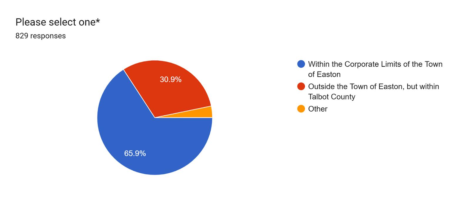
2. Interest in Easton?
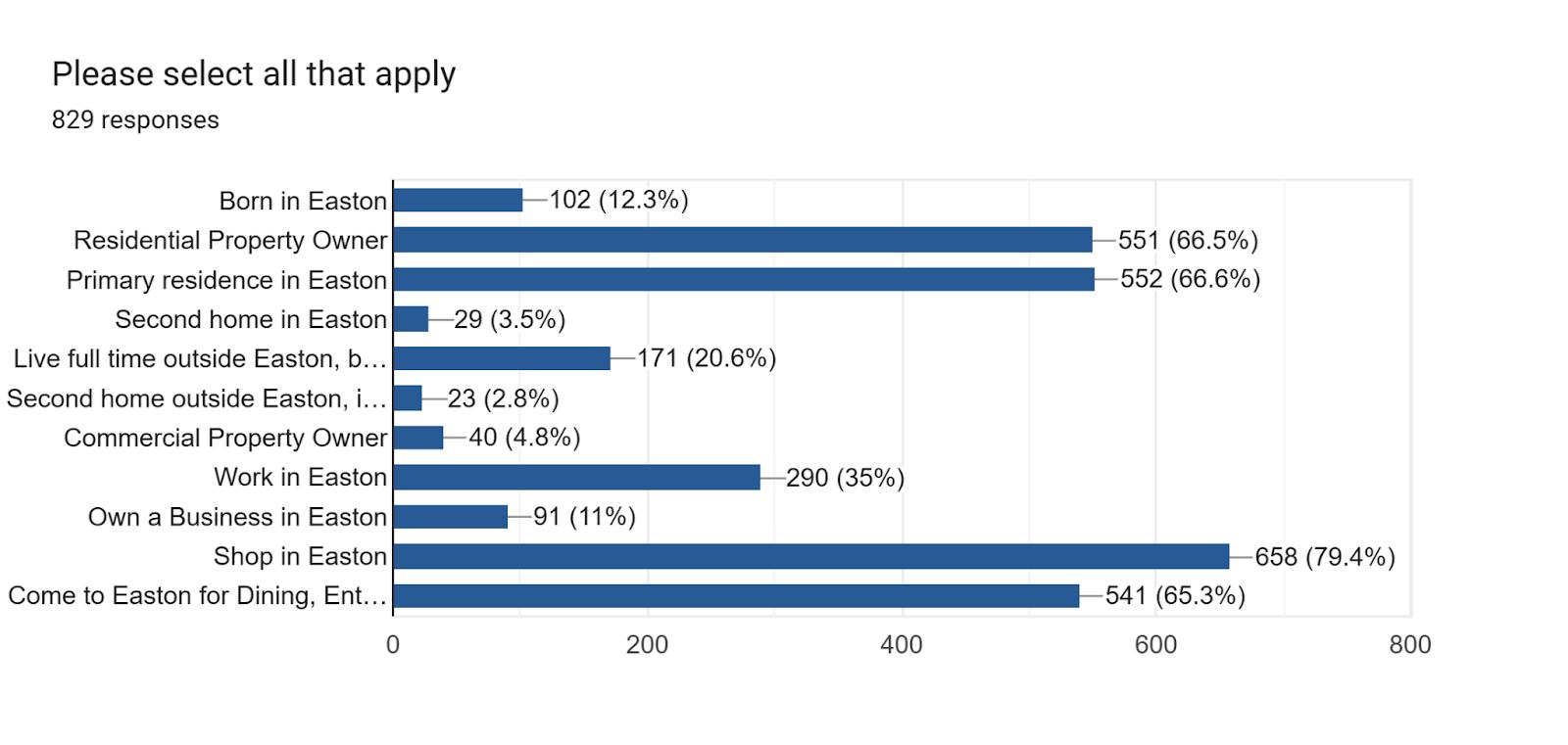
3. Easton’s population is (From 1 = Too Small to 5 = Too Large)
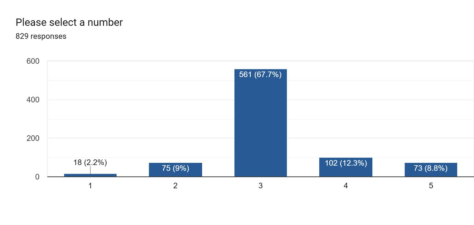
4. Easton’s Rate of Growth is (From 1 = Too slowly to 5 = Too Rapidly)
February 19, 2026
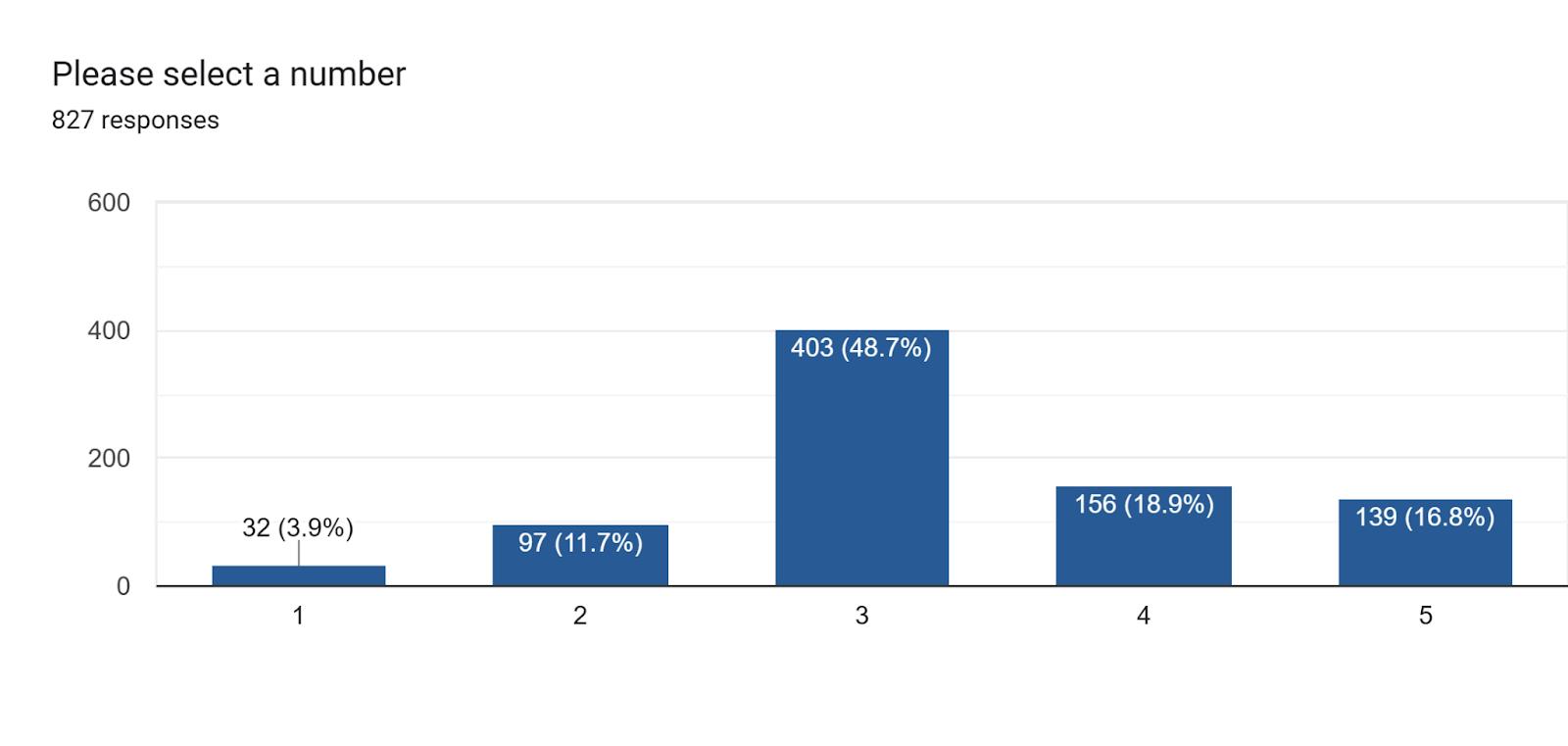
5. The geographic size of the Town is (1 = Too small to 5 = Too Large)
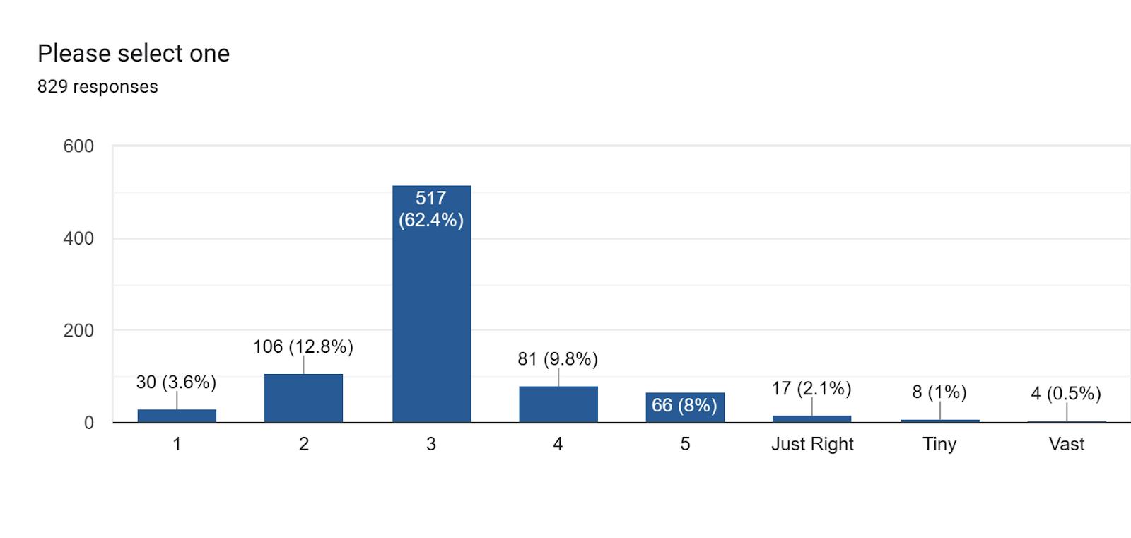
6. Percentage of Future Growth that should be Infill/redevelopment vs. new Greenfield Development
Top 5 Responses:
80/20 Infill (119)
50/50 (83)
100% Infill (67)
75/25 (52)
90/10 and 70/30 (42 each)
7. Amount of Regional-Scale Retail Shopping in Easton (* - In Easton, this has generally come to refer to shopping centers and/or single retail stores in excess of 65,000 square feet of floor space (roughly the size of our Giant or BJ’s, for example) is (1 = Too little to 5 = Too Much):
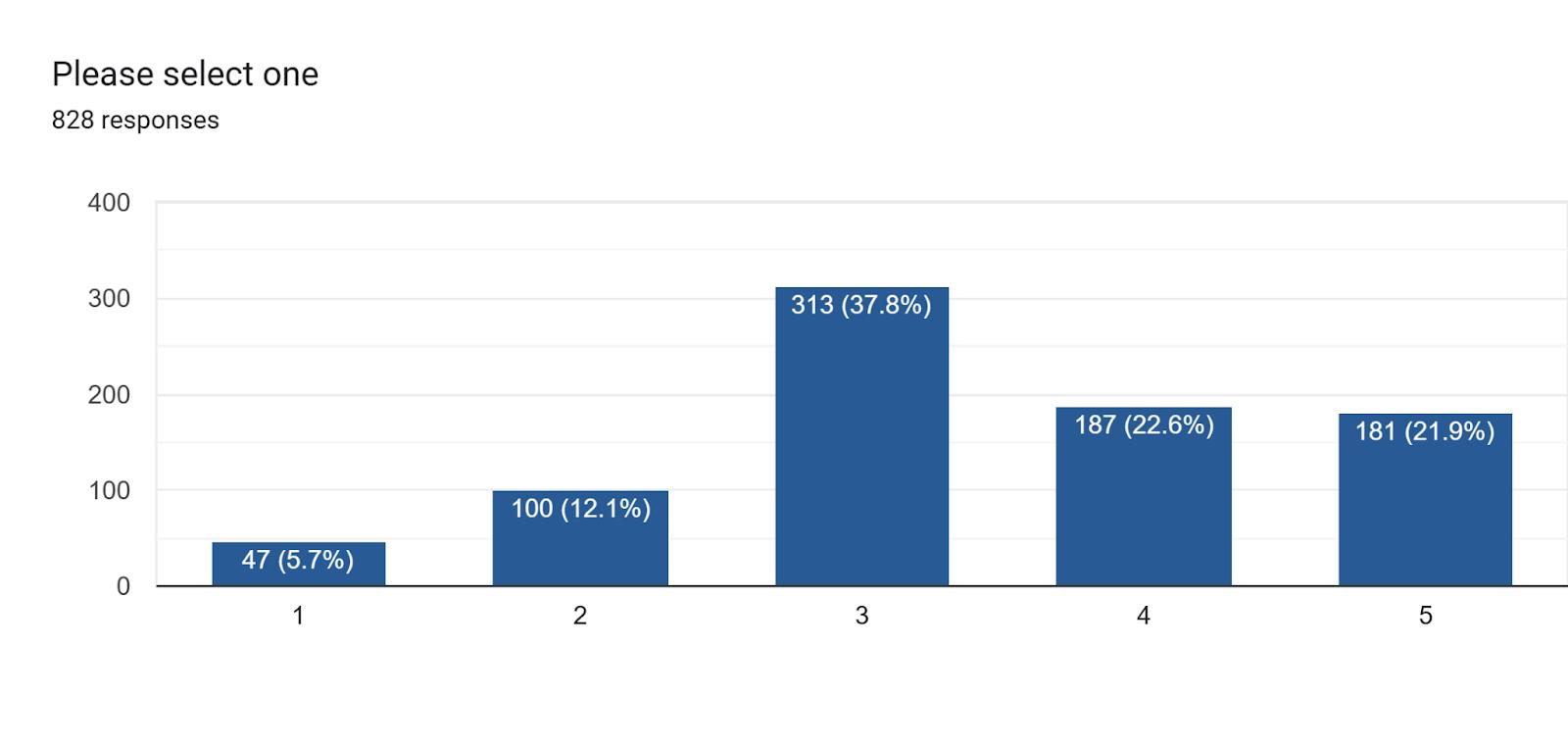
8. Which of the following should be policies of the Town in light of Climate Change Impacts:
19, 2026
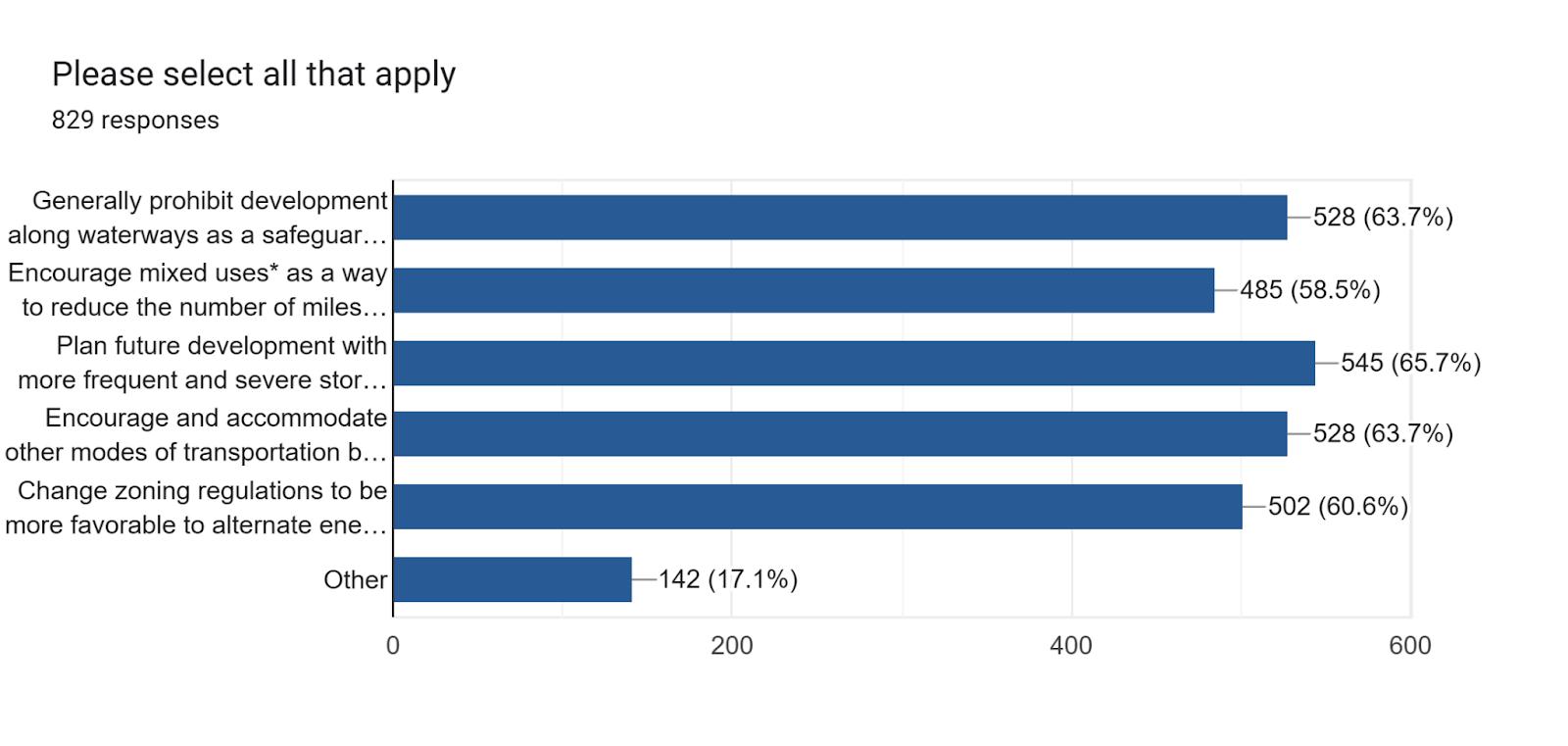
9. Your one “audacious” idea to improve Easton:
Some of the most commonly recurring responses included:
● Boathouse
● Public Waterfront
● Affordable Housing
● Develop Port Street/Waterfront
● Keep Easton small/unique/historic
● More Downtown parking/parking garage
● Control/Limit Growth
● Redevelop/Reuse old/vacant buildings
10. One Thing missing in Easton that you would like to see added in next 10 years:
Most frequently noted suggestions were:
● Trader Joe’s (Far and away the most common response)
● Public Waterfront
● Home Depot
● Steakhouse
● Costco
● Brewery
● Downtown Grocery Store
1. How important is it to maintain each of the components of the overall Town Growth Strategy as stated in the 2010 Comprehensive Plan (1 = strongly disagree with the component to 5= strongly agree with the component):
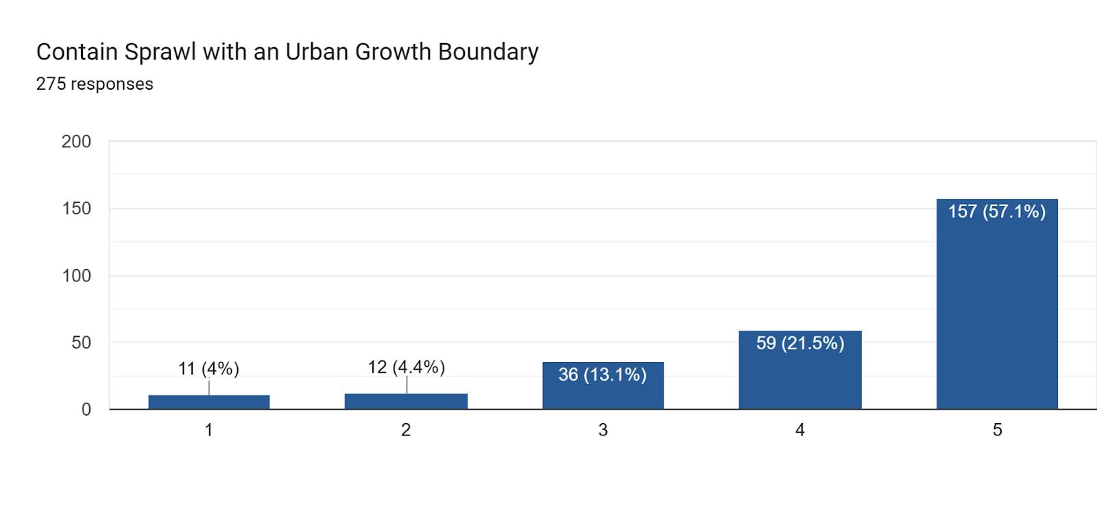

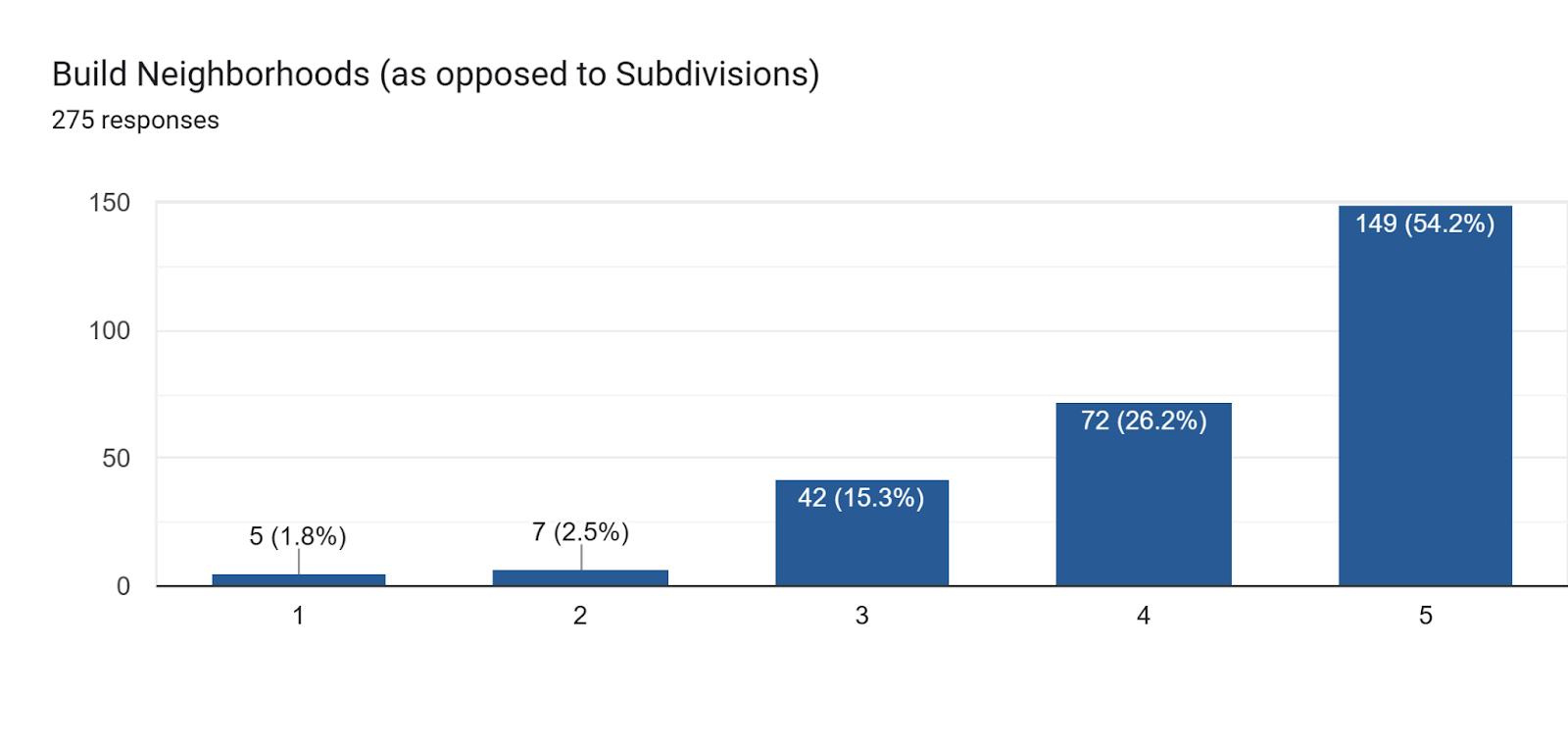

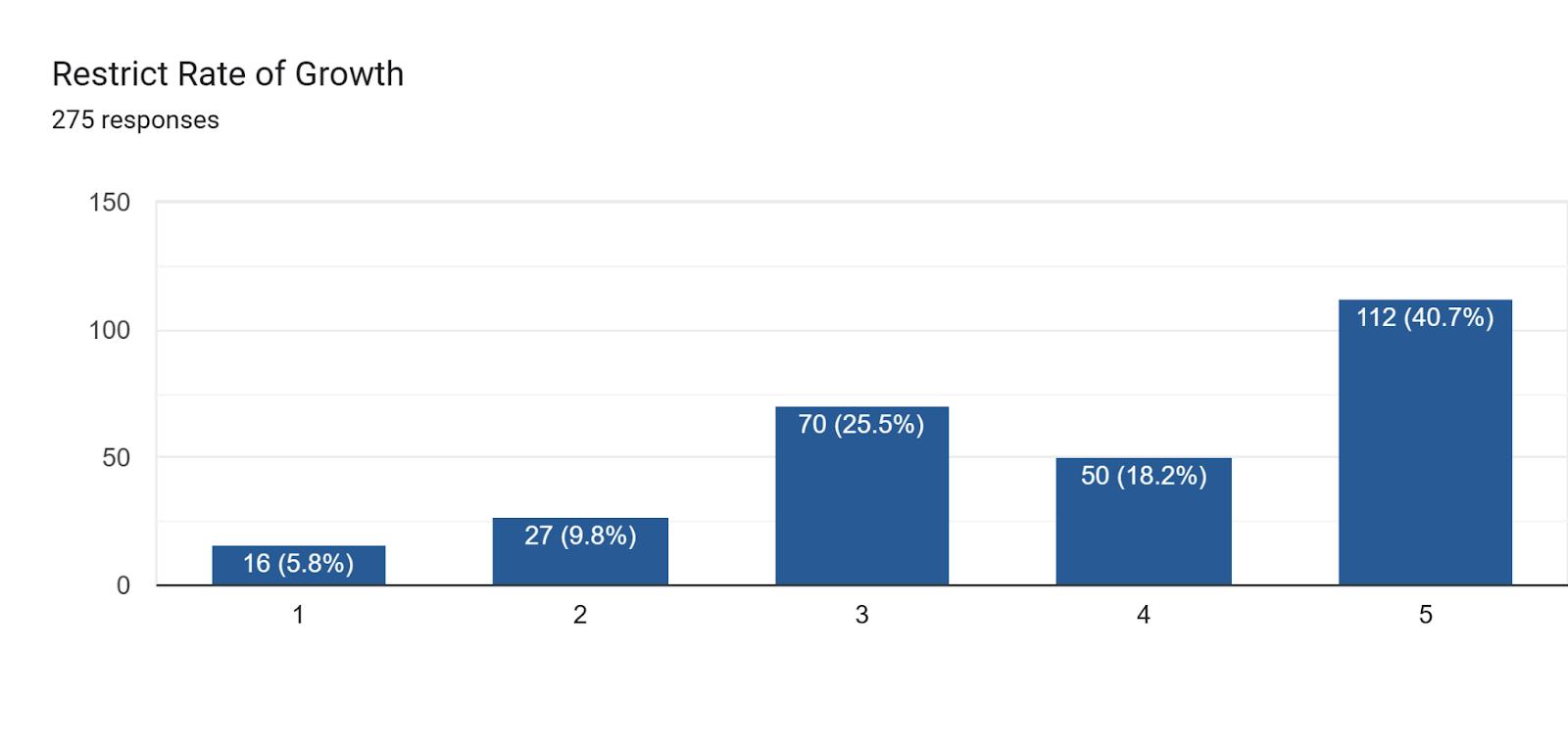
2. Please consider each of the following factors often associated with a community's quality of life and indicate the degree to which you think each factor affects current residents in terms of a decision to potentially locate here:
19, 2026
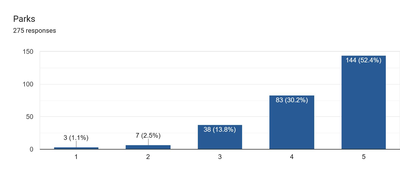
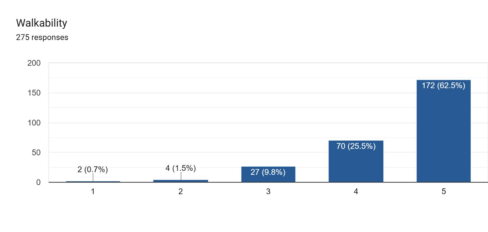
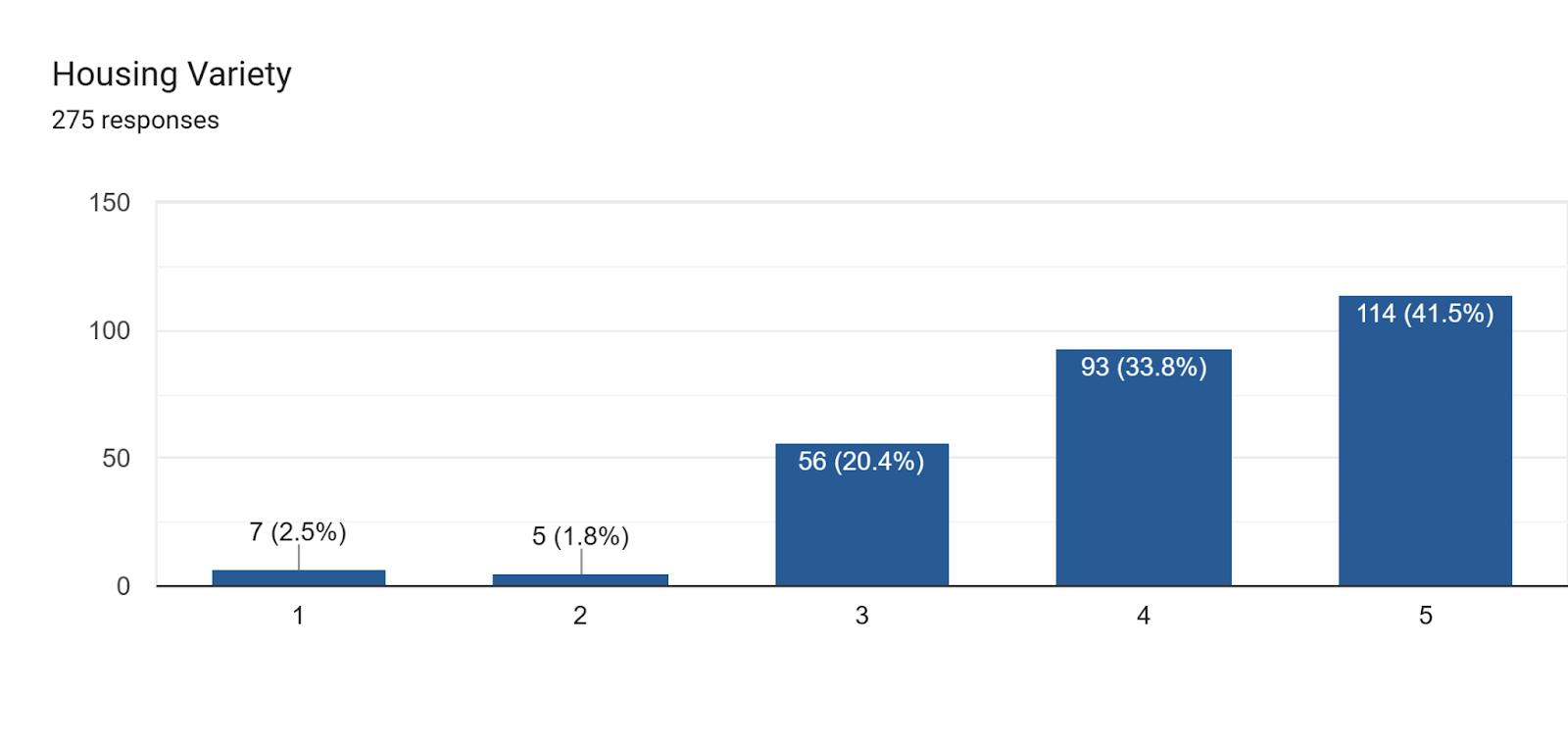
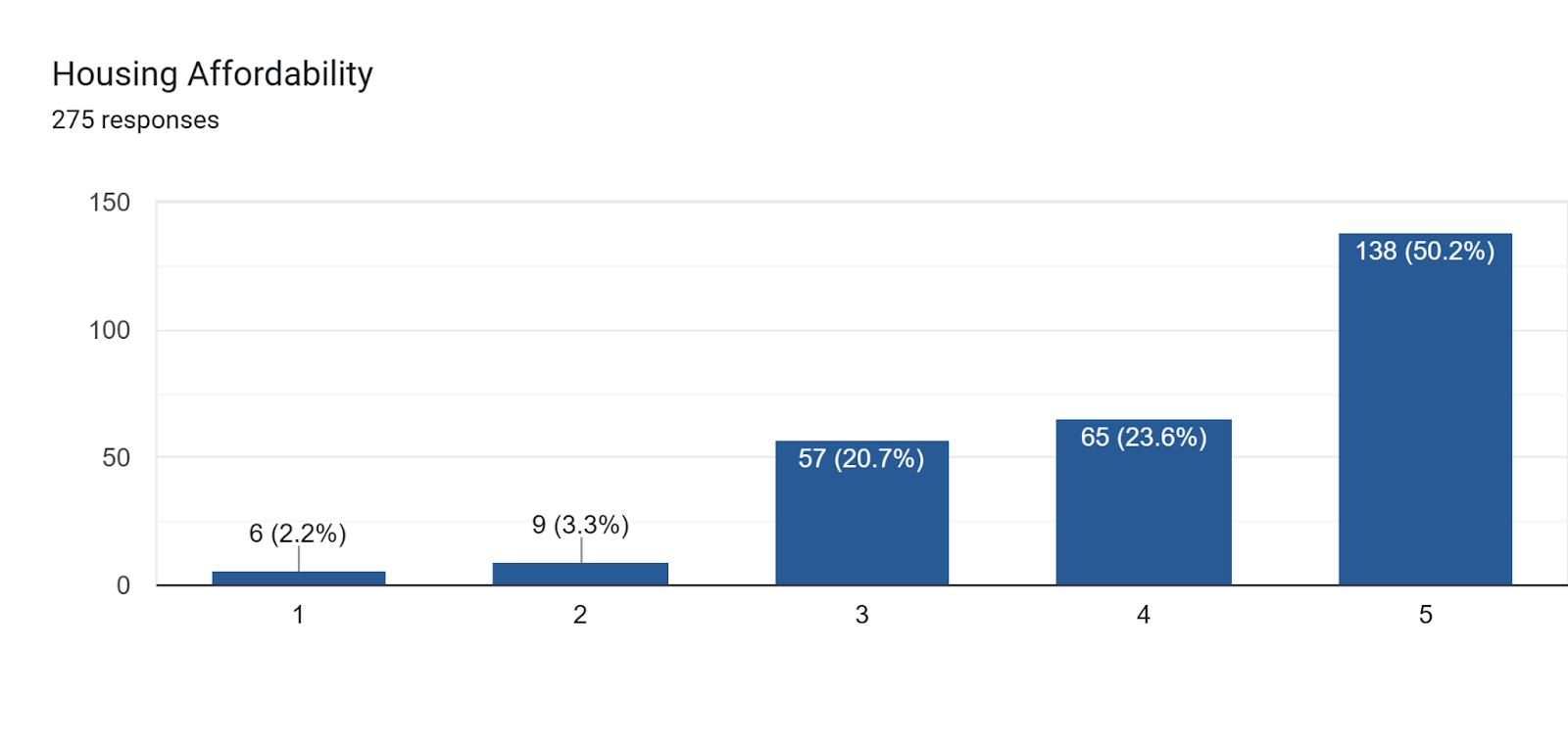
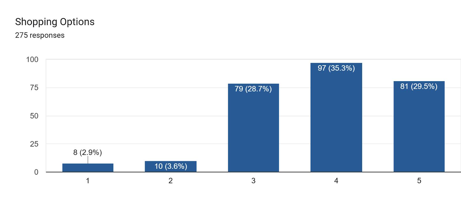
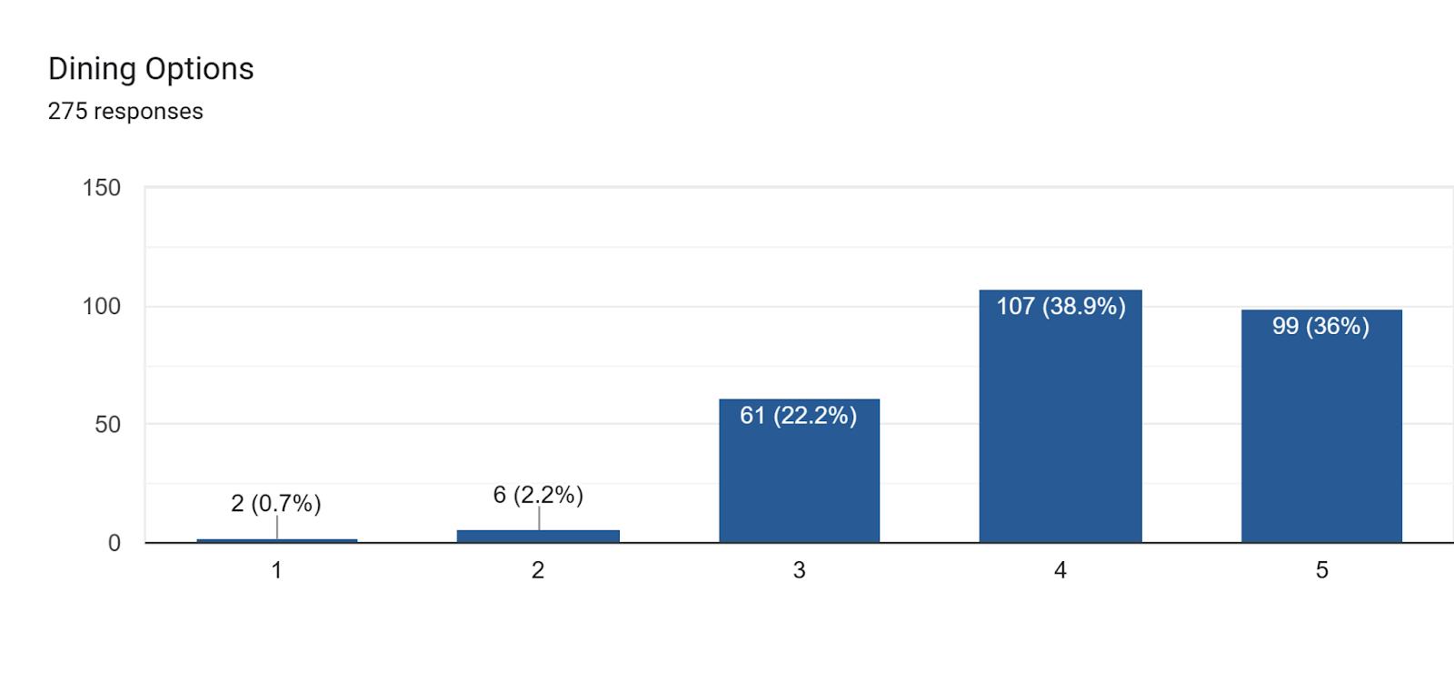
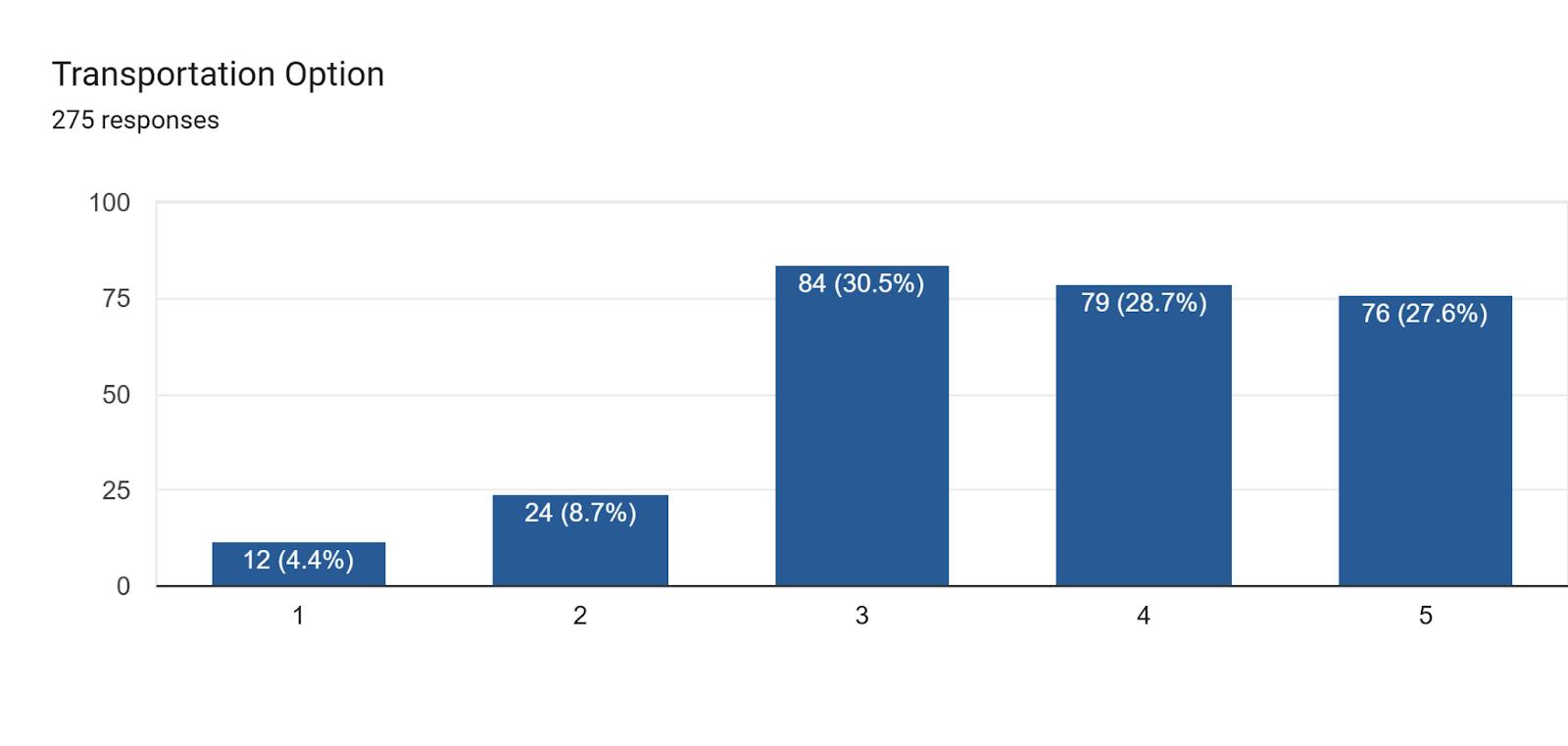
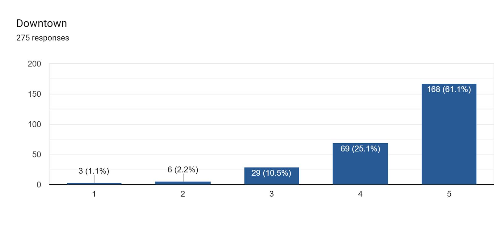
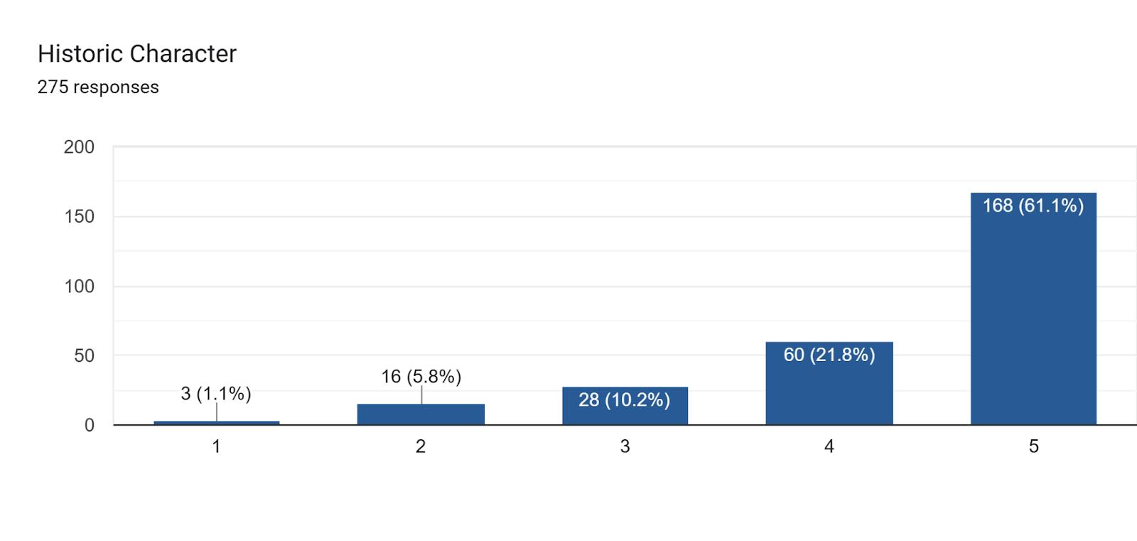
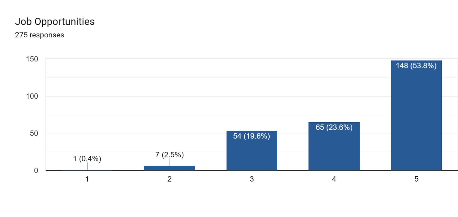
3. Please name one thing that the Town should strive to add or improve in order to enhance the quality of life of our existing residents:
The five responses most frequently mentioned were:
● Affordable Housing
● Grocery Store Downtown
of
243 February 19, 2026
● Public Waterfront
● Parking (Downtown)
● Walkability
4. What is the most important asset/resource/amenity for the Town to protect or enhance as we contemplate the future of our community?
The top three responses were:
● Downtown Charm/Vibrancy/Character
● Green Spaces/Parks
● Historic Character
5. Places most likely to show someone who has never been to Easton before:
Virtually every response included Downtown in general and/or a specific business or institution Downtown.
6. Where would you avoid showing these visitors?:
Frequently recurring responses included:
● Nothing/Nowhere
● Big Boxes
● Route 50
● Port Street
7. The current Comprehensive Plan talks a lot about the desire for Easton to avoid monotonous, cookie-cutter, "Anyplace USA" (Suburban-Style) housing developments. Please indicate how important you think this Vision is for the future of Easton and then the importance of each of the following policies in Town of Easton 244 February 19, 2026
achieving this goal:
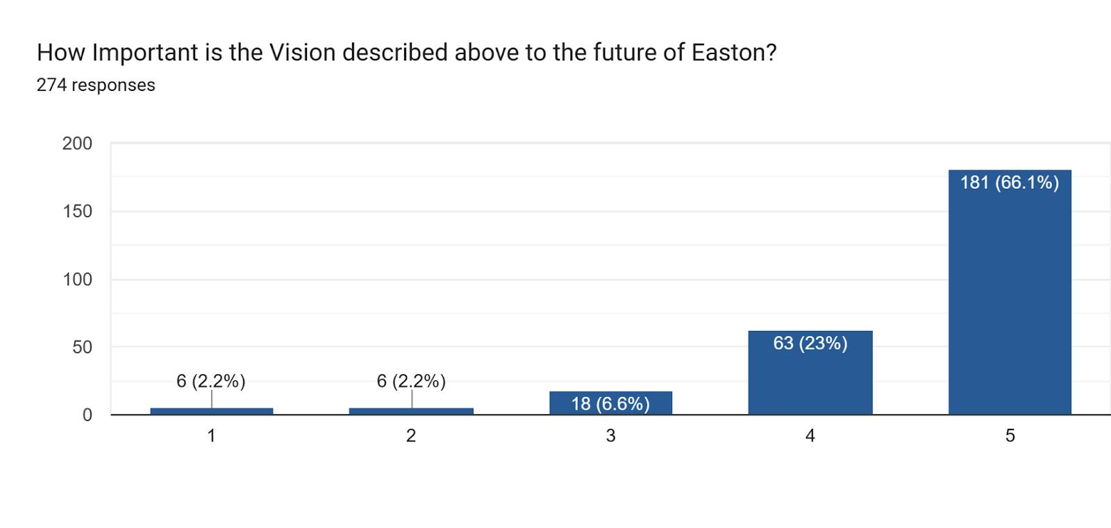
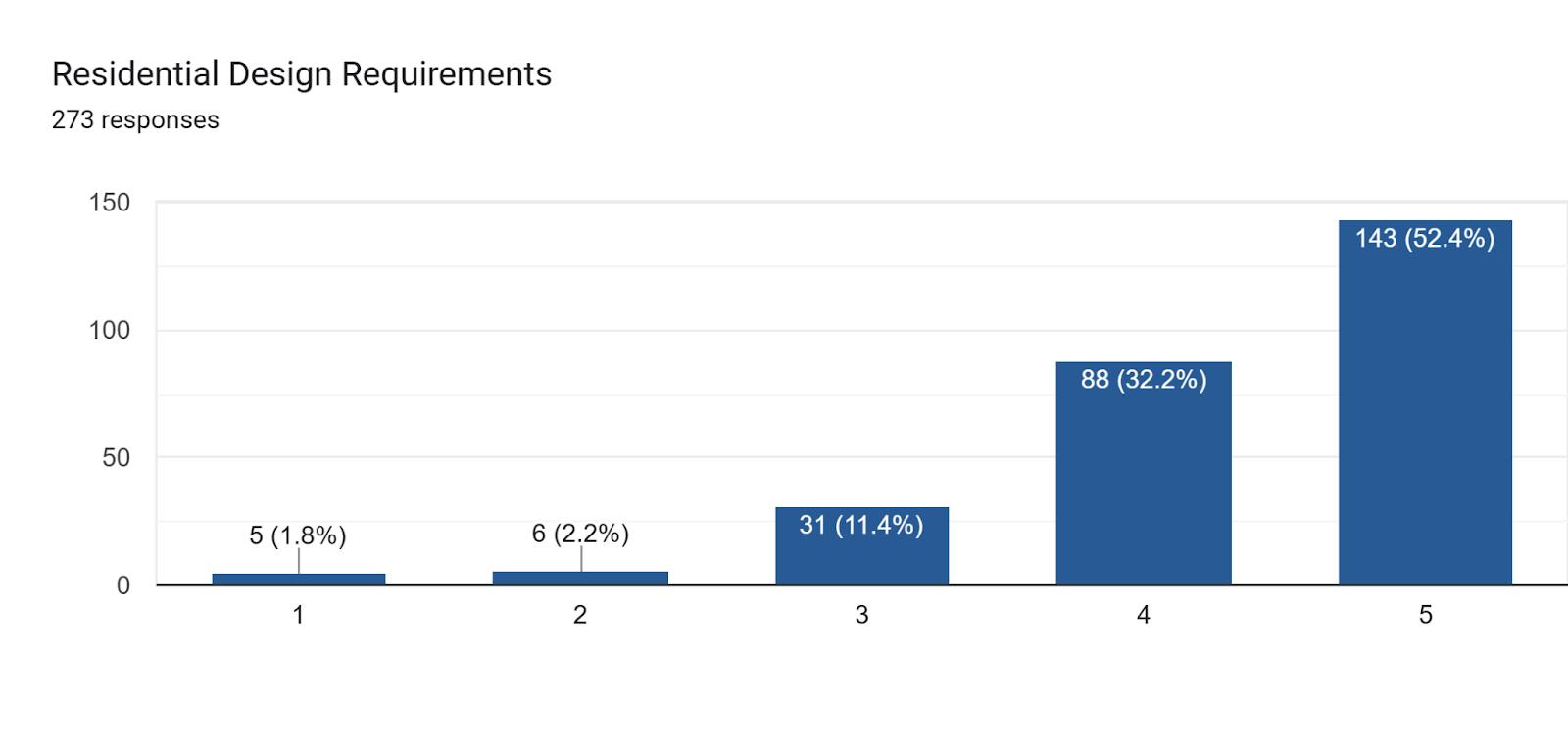
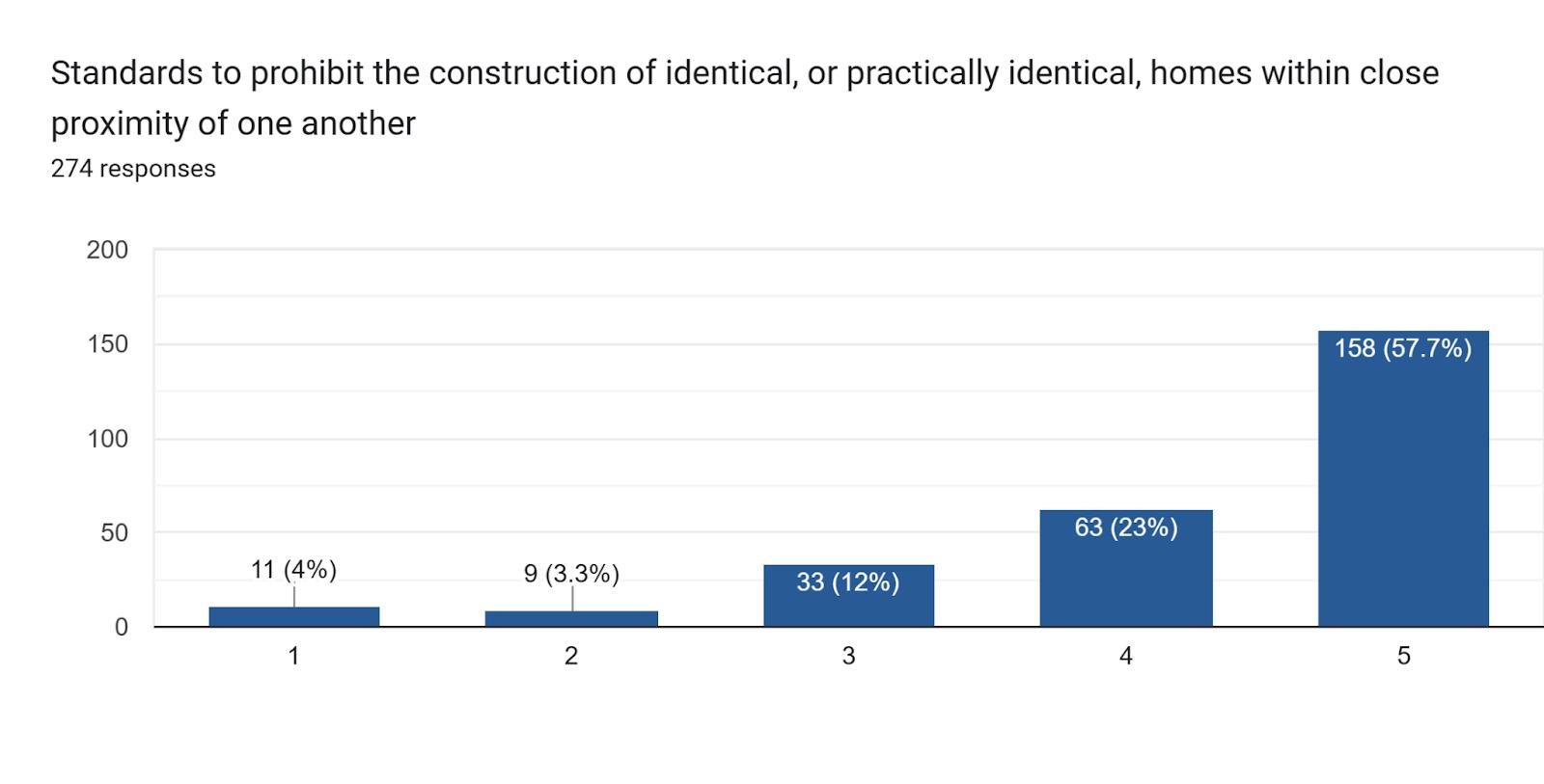
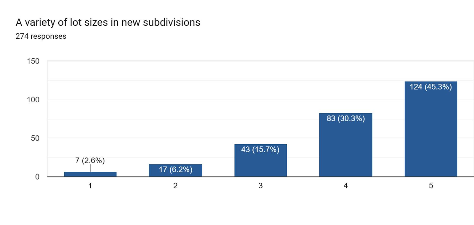
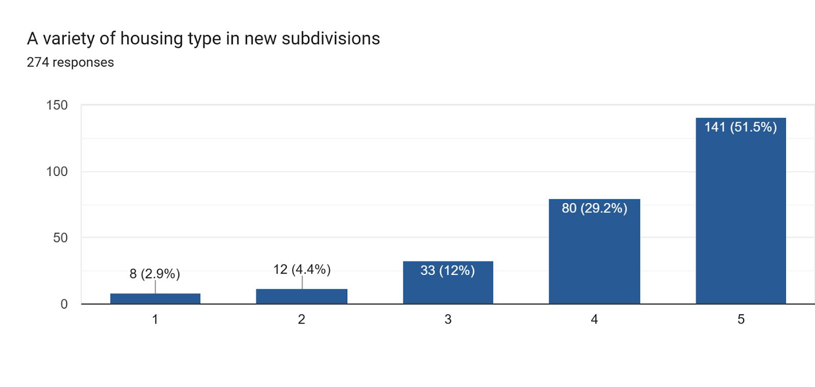
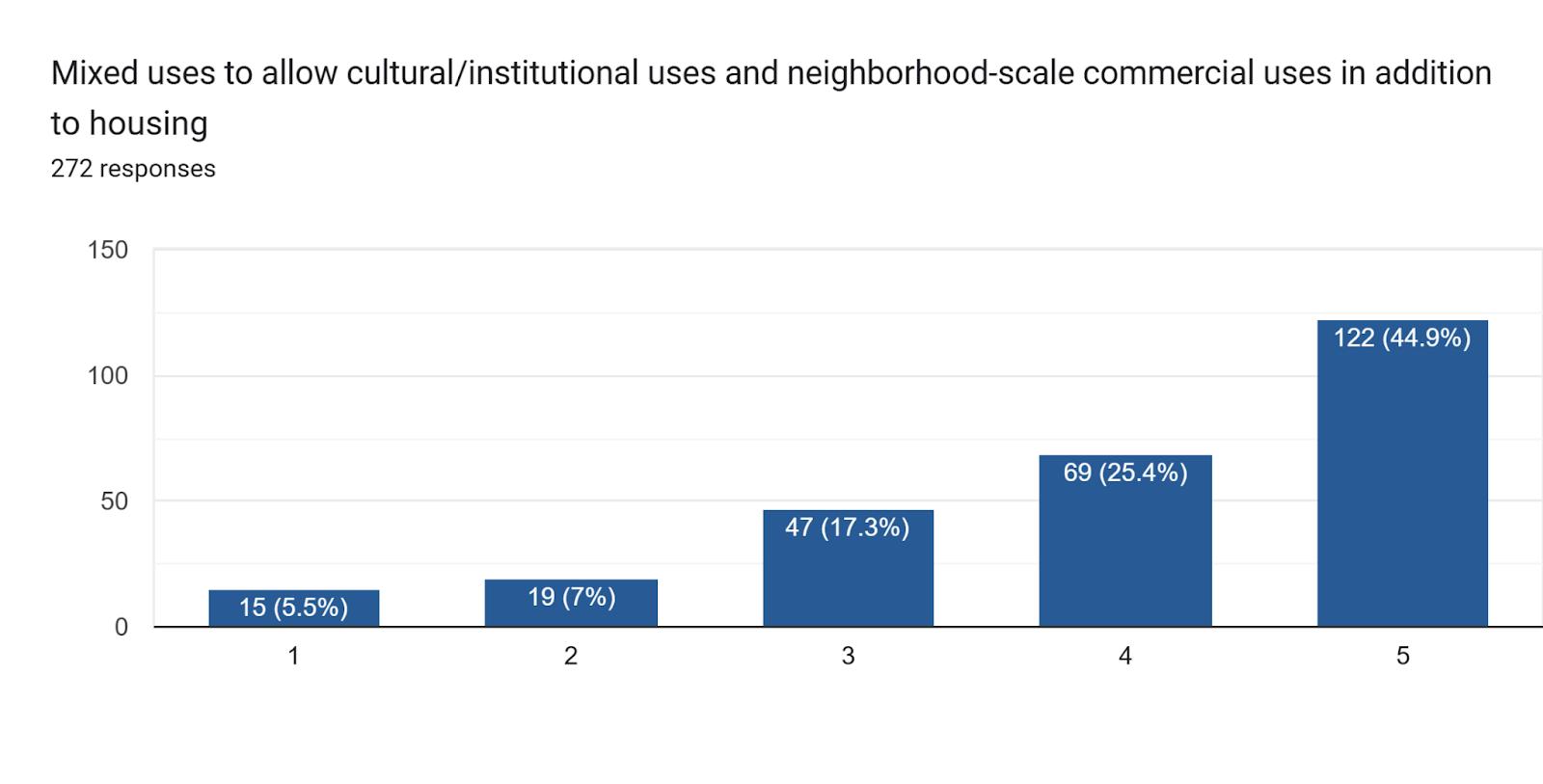
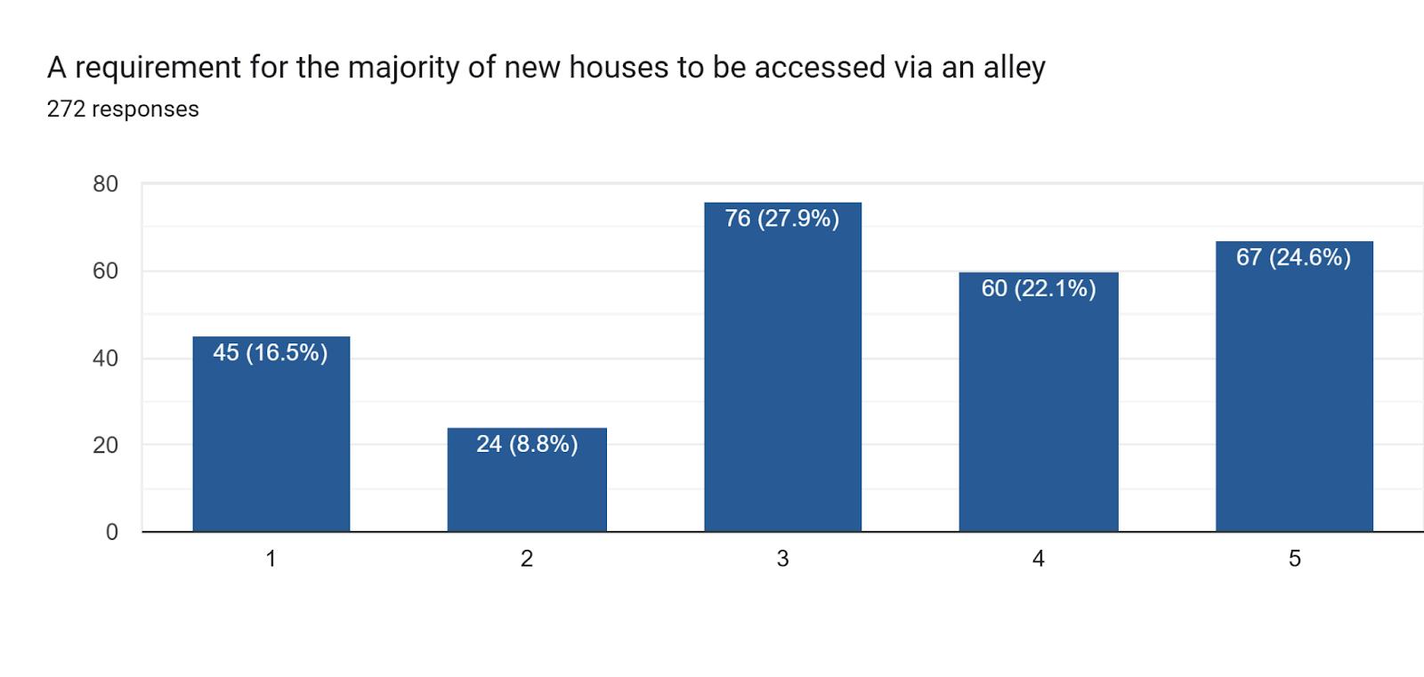
8. How should the current hospital site be redeveloped/reused?
Top Responses were:
● Affordable Housing
● Housing (in general)
● College
● Medical Use
● Mixed-use
● Park/Open Space
9. Which of the following would you support even if it meant a tax increase?:
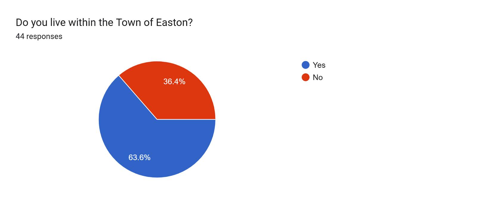
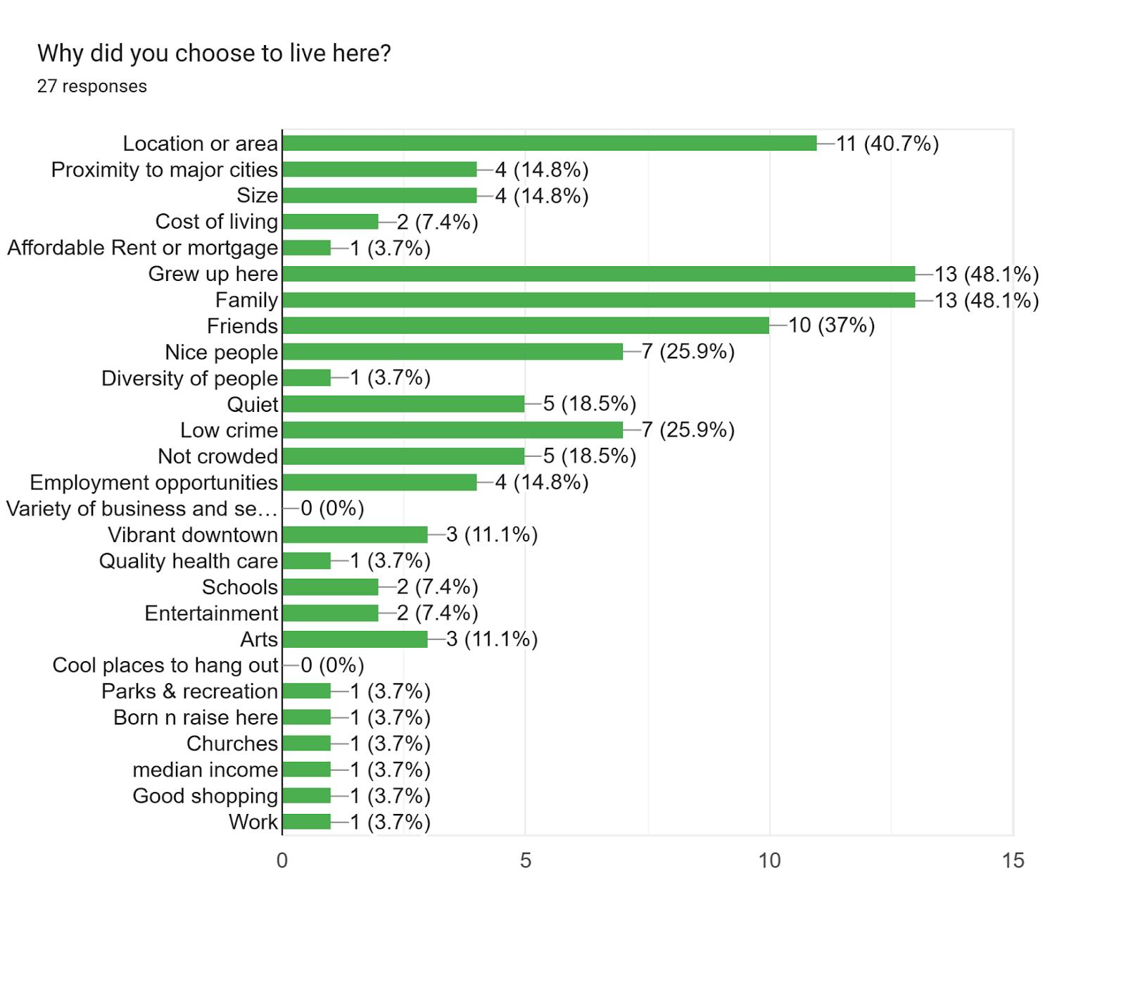
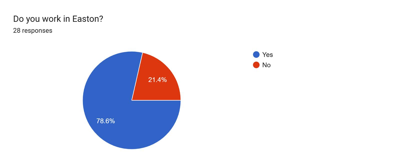
For non-Easton residents:
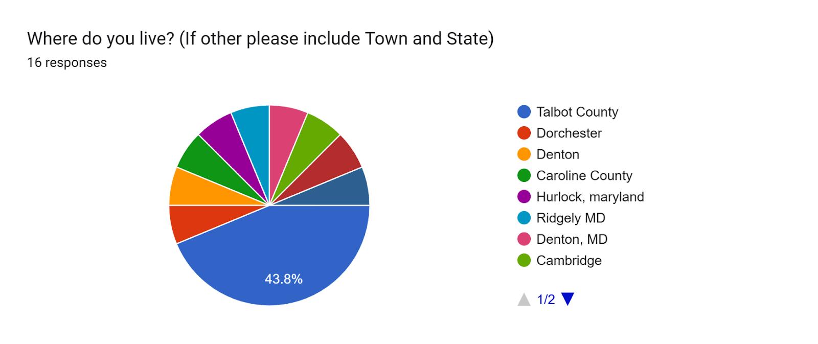
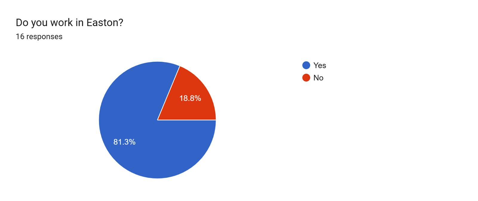
Would you consider living in Easton? Why or why not?
Yes
Wish I could afford it. Lived here my whole life and was pushed our due to rent.
Yes. If there wasn’t a housing challenge.
yes if i could find something comparable to my house and affordable
Yes, only if there was affordable housing.
Couldn't afford to
Yes.
I would love to but I cannot afford to live in Easton
Ehhh most likely not. Stict ordinances, expensive housing.
Yes, because Easton has more entertainment and a community more involved than surrounding counties.
No, too much crime and too expensive
Yes. Lived in town limits for 25 years and wouid moved back.
No, it’s very stuffy. I used to live in Easton but moved to Cambridge because there are more young people and town activities, as well as better access to the water for people who don’t own waterfront estates.
No, because I have retired.
Yes because of the vibe of the town, especially downtown
What type of business or entertainment option would you like to see that isn't here right now?
AI summarized responses:
● Entertainment: Many responses requested more entertainment options such as arcades, mini-golf, larger music/theater venues, comedy clubs, and indoor sports facilities, including an ice rink. There was also interest in adult-focused entertainment like adult arcades and safer bars/nightlife.
● Restaurants & Food Options: Respondents expressed a desire for a wider variety of restaurants, including specific chains like Shake Shack, Five Guys, Mod Pizza, Texas Roadhouse, Buffalo Wild Wings, and Trader Joe's. They also requested more diverse dining options (e.g., Greek, Mediterranean, African, Dominican/Puerto Rican, Thai, gastropub, lobster house), a bakery, and more affordable local restaurants.
● Retail & Services: Suggestions included a bigger Walmart, Costco, Home Depot, chocolate Town of Easton 252 February 19, 2026
shop, beauty and wellness spas, tattoo shops, and a cat petting business.
● Community Amenities & Infrastructure: Several responses highlighted the need for more activities for youth and teens, a splash pad park, bike lanes, a bus system, and public transportation to locations like DC. There was also a request for a place of worship not Christian related.
● Other: A few respondents mentioned a gun range, a brewery, or indicated that they already have what they need in Easton. What words describe your impression of Easton?
● Town Atmosphere: Many described Easton as charming, quaint, small, and quiet, with a peaceful, friendly, and laid-back vibe.
● Demographics & Lifestyle: Several responses noted Easton as a retirement community geared towards retirees and wealthy members, with a "rich white people" or "preppy" impression.
● Amenities & Walkability: Some respondents highlighted cosmopolitan amenities, walkability, and a sense of safety
● Perceived Issues: A few responses mentioned high prices, a perception of being crime-ridden and run down, or being "unduly self satisfied."
● Overall Impression: Easton was broadly seen as a nice, beautiful, and enjoyable town, with some calling it "perfect" or stating "everything works."
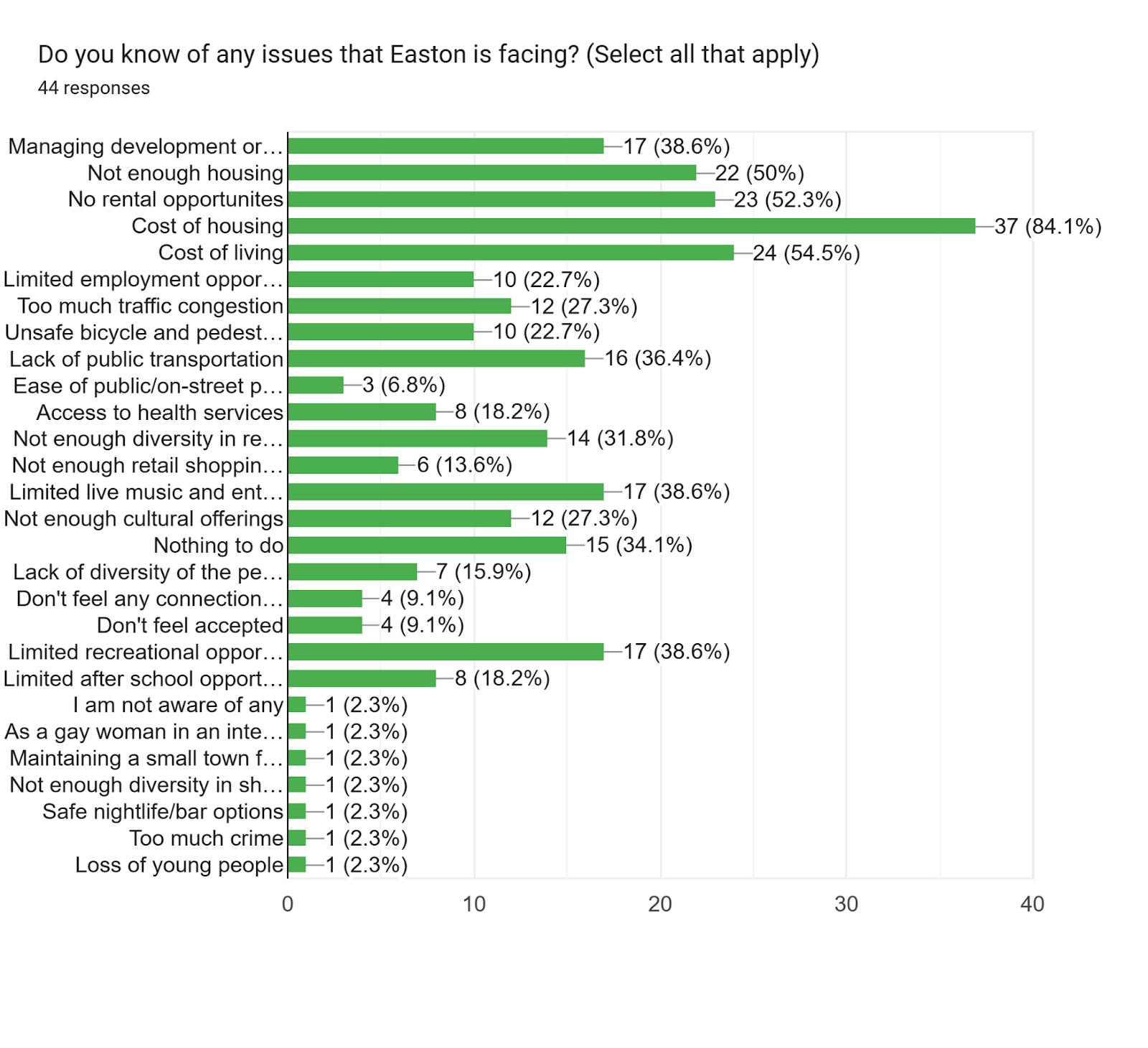
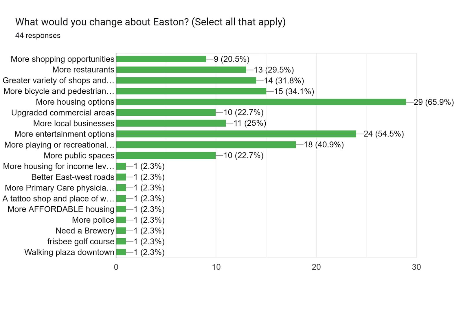
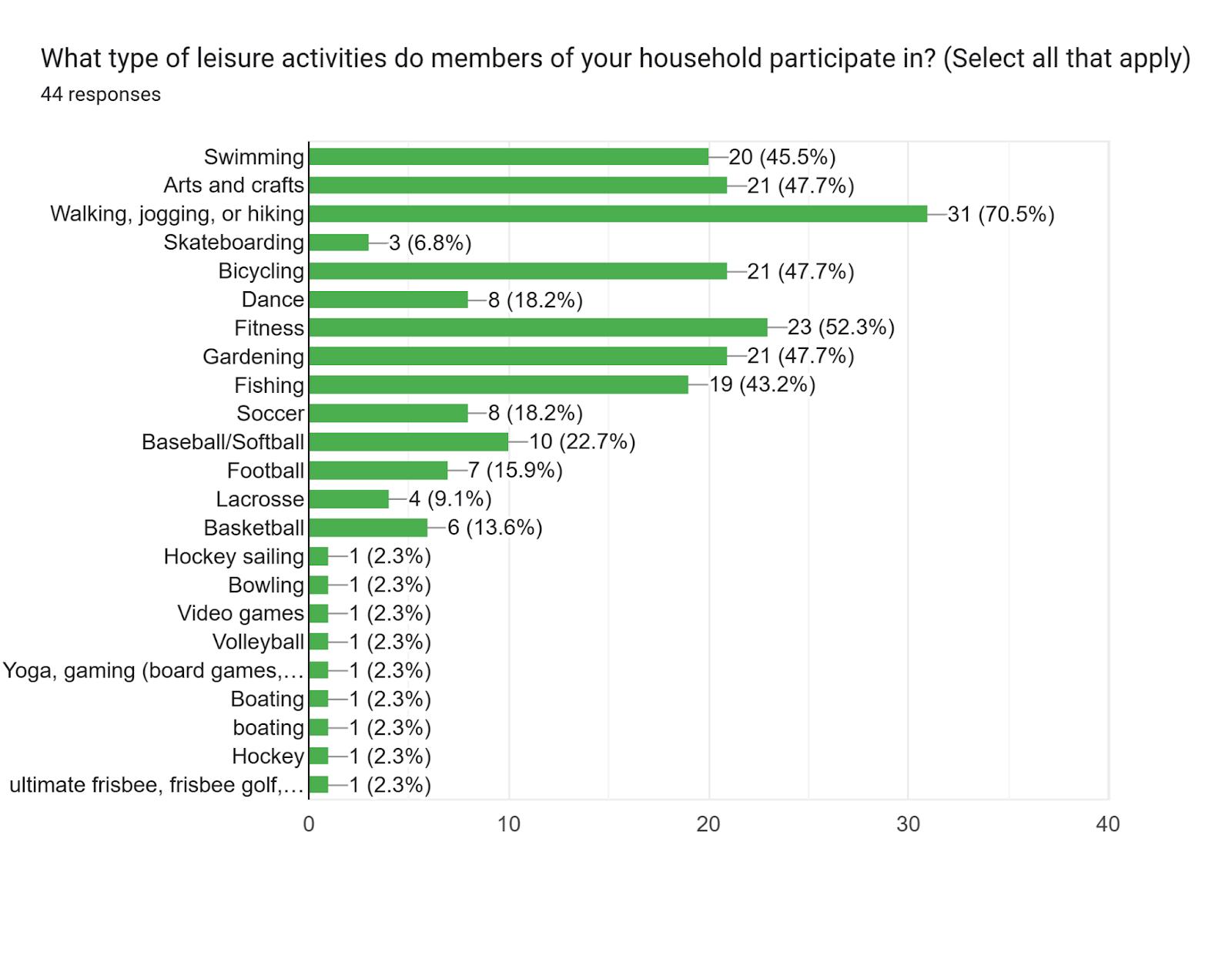
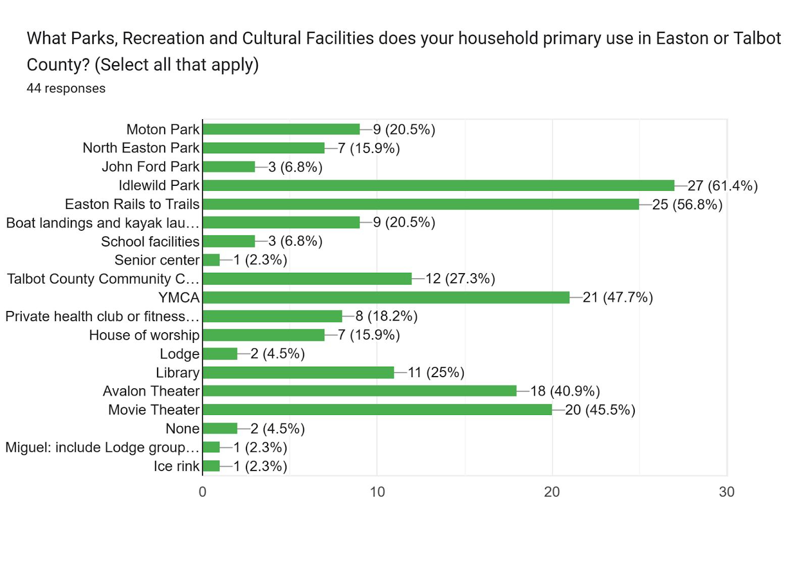
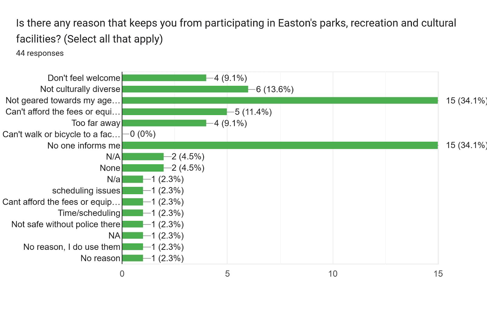
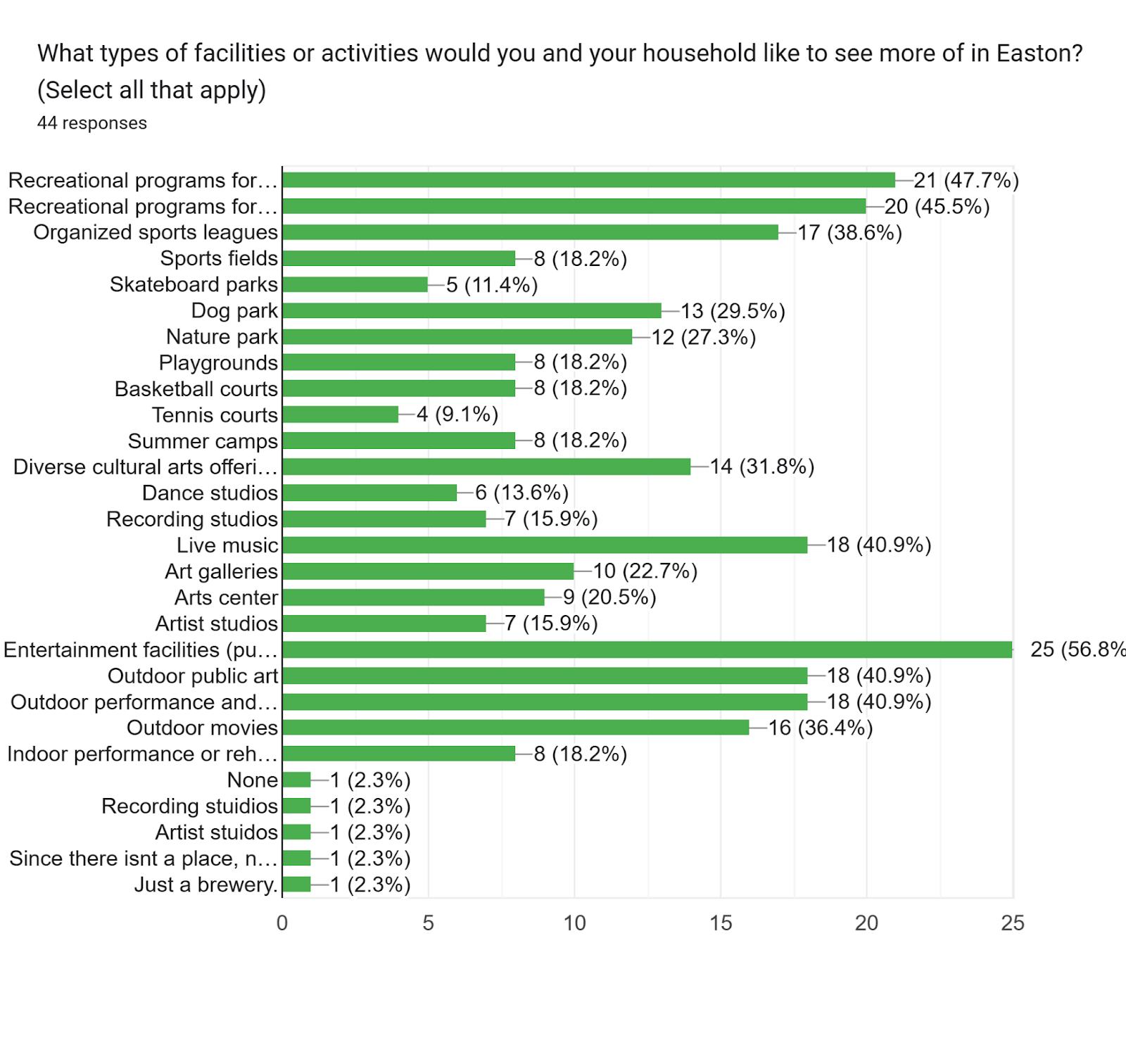
Land Use and Septic Systems (See Scenario Descriptions Below)
Impervious Cover and Open Space
Scenario Description
Year 2007 with 2007 Level of BMP Implementation
Year 2007 with TS BMP Implementation
Scenario 1 Build-out (or 3% Growth 2040)
Scenario 2 - 2040 1% Growth, 75% infill, 25% greenfield
Scenario 3 - 2040 1% Growth, 50% infill, 50% greenfield
Scenario List
2007 LU, 2007 BMPs
2007 LU, Trib Strat BMPs
Scenario 1
Scenario 2
Scenario 3
PROJECT
DESCRIPTION
New Water Services & Meters
Replace Hydrants
Replace Valves
Easton Watermain Replacement Judas St & Port St
Looping Water Mains/Blow-offs
SCADA, PLC & Security Upgrades
Well No 12 Security Fence
Corrosion InhibitorSequestering Agent
Well No. 12 – Replacement of Pump and Column Pipe
Cast Iron Water Main and Valve Replacements
New Water Treatment Plant (Commerce Drive)
UMMS Water Main Extension
EASTON WATER SYSTEM
CAPITAL IMPROVEMENT PROJECTS
PROPOSED FISCAL YEAR
FY2026
FY2026
$304,000
$40,000
FY2026 $90,000
FY2026
FY2026
FY2026
FY2026
COMMENTS
$1,051,000
$32,000
$60,000
$16,000
FY2026-2027 $88,000
FY2027
FY2027
FY2027-2028
FY2027-2028
$250,000
$1,167,000
$12,000,000
$3,433,000 Hydrant Rehab & Storz Connect
New Well No 14
Looping Water Mains/Blow-offs
New Water Services
New Water Meters
Replace Hydrants
SCADA, PLC & Security Upgrades
FY2027-2028
FY2027-2028
FY2027-2031
$836,000
$2,625,000
$173,000
FY2027-2031 $175,000
FY2027-2031
$1,370,000
FY2027-2031 $215,000
FY2027-2031 $132,000
UMMS Water Tank FY2028 $3,124,000
Well No. 6 – Replacement of Pump and Column Pipe FY2028 $130,000
Well No 8 – Replacement of Pump and Column Pipe
Cast Iron Water Main and Valve Replacements
Matthewstown Tank Refurbishment or Demo
Cast Iron Water Main and Valve Replacements
Cast Iron Water Main and Valve Replacements
Well No. 7 – Replacement of Pump and Column Pipe
FY2028 $130,000
FY2028 $1,167,000
FY2029
FY2029
$500,000
$1,228,000
FY2030 $1,157,000
FY2031
$140,000
Iron Water Main and Valve Replacements
New Well No. 14 (Magothy Aquifer) ¶
New Water Treatment Plant ¶ (Commerce Drive) ¶
Cast Iron Water Main and Valve ¶ Replacements ¶
Matthewstown Tank – Cleaning & Painting
No. 12 – Replacement of Pump and Column Pipe
Cast Iron Water Main and Valve ¶ Replacements ¶ ¶ ¶
Looping Water Mains ¶ FY2029 ¶ $250,000¶
Cast Iron Water Main and Valve ¶ Replacements ¶ ¶ ¶
Looping Water Mains ¶ FY2030 ¶ $250,000¶
Cast Iron Water Main and Valve ¶ Replacements ¶ ¶ ¶
Looping Water Mains ¶ FY2031 ¶ $250,000¶
Well No. 7 – Replacement of Pump and Column Pipe ¶ ¶ ¶
Cast Iron Water Main and Valve ¶ Replacements ¶
Looping Water Mains ¶
¶ $1,000,000¶
¶ $250,000¶
Cast Iron Water Main and Valve ¶ Replacements ¶ ¶ ¶
Looping Water Mains ¶ FY2033 ¶ $250,000¶
EASTON SEWER SYSTEM
CAPITAL IMPROVEMENT PROJECTS
PROJECT DESCRIPTION PROPOSED FISCAL YEAR COMMENTS
Windmill Pump Station and Force Main Replacement
Windmill Interceptor Sewer Refurbishment
Clifton Pump Station – Refurbish Pumps, Grinders, Replace ATS, VFDs, Relocate Bypass Piping
Calvert Pump Station – Refurbish Pumps, Grinders, Replace ATS, VFDs
SCADA, PLC & Security Upgrades
New Wastewater Laterals
WWTF - Bio. Reactor #2 Refurb.
WWTF - Secondary Clarifiers #1 & #2 Refurbishment
WWTF - Tertiary Treatment Sand Filter Refurbishment
WWTF - Primary & Secondary Lagoon Flow Control Refurbishment
Calvert Pump Station – Replace Pumps, Refurbish Grinders
WWTF - Influent Box and Headworks – Gates and Actuators
Wastewater Pumps Station –Generator Replacement
Sewer Main Replacement – Arcadia St
UMMS Pump Station & Forcemain
South Pump Station – Refurbish Pumps, Grinders, Replace VFDs, ATS
WWTF - Influent Box and Headworks – Fine Screens Rehab
WWTF - Sludge Dryer Design & Replacement
North Pump Station – Refurbish Pumps, Grinders, Replace VFDs,
WWTF – Lagoon Diversion Structure Corrosion Control
WWTF - Bio. Reactor #1 Refurb.
FY2026
FY2026
$9,809,000
$1,900,000
FY2026-2027 $234,500
FY2026-2027 $200,000
FY2026-2031 $191,500
FY2026-FY2031 $371,00
FY2027 $481,000
FY2027
$580,000
FY2027 $938,000
FY2027 $614,000
FY2027 $200 000
FY2027 $263,000
FY2027
FY2027
FY2027
$42,000
$200,000
$12,100,000
FY2027-2028 $125,500
FY2028 $110,500
FY2027-2028
FY2028-2029
FY2029
FY2031
$8,900,000
$143,000
$45,000
$500,000
–
FY2027 through FY2034
$11,900,000
PROJECTDESCRIPTION¶ PROPOS ED¶ FISCAL YEAR¶
COMMENTS¶
WindmillPumpStation Replacement¶ FY2024¶ $2,800,000¶
WindmillForceMain Replacement¶ FY2024¶ $2,418,000.¶
SewerMainandManhole ¶ Refurbishment¶ ¶ ¶
CalvertPumpStation Refurbishment¶ FY2024¶ $165,000¶
WWTFEngineeringforLarger ¶ CapacitySludgeDryer¶ ¶ ¶
SewerMainandManhole ¶ Refurbishment¶ FY2025¶ $1,000,000¶
WWTFReactor#2-Aerator #503& #504Gearbox&Motor Rebuilds,and RepaintingAerator Paddles¶ FY2025¶ $290,000¶
SewerMainandManhole ¶ Refurbishment¶ FY2026¶ $1,000,000.¶
WWTFClarifiers#1 Gearbox ReplacementandPainting ofSkimming Arms,Scapes,and Structure¶
FY2026¶ $540,000.¶
WWTFUVSystem Replacement¶ FY2026¶ $325,000 ¶
WWTFSludgeDryer Replacement¶ FY2026 &2027¶ $7,400,000.¶
SewerMainandManhole ¶ Refurbishment¶ FY2027¶ $1,000,000.¶
SewerMainandManhole ¶ Refurbishment¶ FY2028¶ $1,000,000¶
SewerMainandManhole ¶ Refurbishment¶ FY2029¶ $1,000,000¶
SewerMainandManhole ¶ Refurbishment¶ FY2030¶ $1,000,000.¶
WWTFReactor#1-Aerator #501& #502Gearbox&Motor Rebuilds,and RepaintingAerator Paddles¶ FY2030¶ $290,000.¶
SewerMainandManhole ¶ Refurbishment¶ FY2030¶ $1,000,000.¶
SewerMainandManhole ¶ Refurbishment¶ FY2031¶ $1,000,000¶
SewerMainandManhole ¶ Refurbishment¶ FY2032¶ $1,000,000¶