By Lars Harrie, Perola Olsson, Weiming Huang and Jing Sun
feature
Exploring the Opportunities and Challenges
Using BIM Data Together with City Models An increasing number of cities are creating 3D city models to support visualization and simulations in the urban planning process. The 3D city models are often extended with planned buildings. One way to facilitate this is to add simplified building information modelling (BIM) models of the planned buildings to the 3D city model. This article summarizes some of the recent academic and industrial studies of this topic.
There are several commercial and opensource tools for integrating BIM data into 3D city models (Figure 1). The integration is complicated, as it requires transformation between different information models (ontologies), e.g. between the open BIM format Industry Foundation Classes (IFC) and the open 3D city model format CityGML. The transformation of geometries is also challenging and includes a conversion from solid modelling (used in BIM) to boundary representations (used in city models).
In 2019, a GeoBIM benchmark was launched to study the interoperability in the GeoBIM domain, where GeoBIM stands for an integration between city models and BIM. The benchmark – which was coordinated by the 3D Geoinformation Group at TU Delft, the Netherlands – focused on the interoperability of tools implementing the CityGML and IFC standards, as well as on tools for conversion between the standards. For the latter, some extract, transform & load (ETL) scripts (mainly from Safe Software) were evaluated,
and several software tools were tested on four datasets. One conclusion drawn is the problem that IFC files are modelled in different and incompatible manners in terms of the IFC elements that are used and their structure. This makes it challenging to write generic programs to convert IFC data to proper CityGML models. In addition, most IFC elements in the benchmark were translated into generic CityGML objects, which in practice would require manual inspection and modification. To tackle these challenges, the
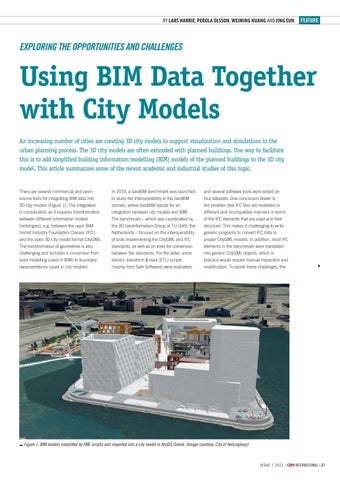
Figure 1: BIM models simplified by FME scripts and imported into a city model in ArcGIS Online. (Image courtesy: City of Helsingborg)
i ssue 7 2 0 2 1 |
27-28-29_featureharrie.indd 27
international | 27
11-11-21 13:40


