Research vessel innovation, sensors and equipment: the Dutch way
How the hydrographic sector is heading towards more autonomous solutions
Get Hands-On with the Latest Marine Technology
Visit Teledyne Marine at Ocean Business 2025!
At Stand T7 - Explore our Latest Marine Technologies:
• Workhorse Proteus: Oceanography with ultimate flexibility and actionable data.
• Intrepid System: Precise positioning for ASVs.
• SeaBat T51-S: Sonar with depth capability up to 6000m.
• Valeport pH Sensor: Robust and high-accuracy pH measurements.
... And more to be revealed at our Launch Party, April 8 at 16:00 (Stand T7)
Live Demos: On-Water & Dockside
We’re bringing our products to life with interactive dockside (HS 02) and on-water demos. Experience the new Intrepid system or book an on-water demonstration of the SeaBat T51-R, showcasing the latest features. Save your seat today!
... But we don’t stop there!
Join us at our Launch Party at Stand T7 on April 8 at 16:00 – for the reveal of even more new products.
Book your seat
We look forward to seeing you there!
Director Strategy & Business Development
Durk Haarsma
Financial Director Meine van der Bijl
Technical Editor Huibert-Jan Lekkerkerk
Head of Content Peter Tapken
Contributing Editor Wim van Wegen
Copy Editor Serena Lyon
Marketing Advisors Myrthe van der Schuit, Sandro Steunebrink
Traffic Manager Linda van der Lans
Design Persmanager, The Hague
The rise of unmanned and artificial
This article explores the significant developments in hydrography over the past ten years and looks ahead to the innovations and trends that are likely to define the next. To do this, one key development has been heavily used: artificial intelligence (AI). This article was initially written with the aid of generative AI (ChatGPT) then redacted by the author to remove the generalities and hallucinations (or most of them).
Towards more autonomous solutions
Bathymetric data increasingly forms a cornerstone for industries planning sustainable marine spaces, enhancing navigation and protecting biodiversity. This shift places hydrography at the heart of global efforts towards sustainability and resilience. As the profession evolves, selecting the right equipment and building the right strategy to maximize its potential are crucial to navigating future challenges and opportunities. This article explores how these factors are shaping the industry’s path forward.
Research vessel innovation, sensors and equipment: the Dutch way
As a Dutchman, it is not entirely surprising that Wim van Wegen primarily encounters hydrography, ocean sciences, marine engineering, and the associated equipment in the Netherlands. Of course, Geo-matching is aimed at a global audience, but that does not make it any less interesting to offer some perspective on the state of affairs regarding data collection and the necessary tools based on his Dutch experiences. This brings him to two Dutch islands, one of which no longer exists.
This picture is taken where the North Sea and the Westerschelde, the estuary of the Scheldt river, meet each other. The coastal sunset features vibrant cloudy skies, with the Breskens lighthouse in Zeeland province providing a striking frame. Stretching over more than 450 kilometres, the Dutch coastline boasts diverse appearances shaped by human and natural forces. Constantly evolving, it offers a dynamic landscape reflecting the interplay of these influences. (Image courtesy: Shutterstock)
Product innovation - a constant in each technology sector!
Welcome to the first edition of the Geo-matching Product Guide, with a special focus on key trends and technological developments in the hydrographic and broader marine surveying sector. Geo-matching was originally created in 2014 to provide easy access to the highly valued product surveys published in our magazines GIM International and Hydro International. Since our inception, we have shared new products and innovations and new and exciting case studies and applications.
Geo-matching, as a key resource for hydrographic and marine surveying equipment, provides a clear overview of technological advancements. In the uncrewed surface vehicle (USV) category, for instance, the range of options is remarkably extensive. With 137 models from 50 manufacturers worldwide, and more models coming every month, there is a lot to choose from. At Geo-matching, we see a strong interest in classic hydrographic applications, but also in port and harbour surveying, environmental monitoring and surveillance and monitoring applications.
One of the key drivers of these new applications is the miniaturization and price accessibility of various sonars, echosounders and positioning equipment – such as inertial navigation systems (INS), GNSS receivers and doppler velocity logs (DVL). One of the smallest INS systems available today weighs only 43 grams for instance, DVLs can weigh less than 1kg, and echosounders are available that weigh less than 790 grams. These systems are not all survey-grade, but the availability of various platforms, sensors and positioning technology creates opportunities for non-surveyors to adopt these technologies. At Geo-matching, we have seen a strong increase in applications such as bridge and port inspection, USVs for water quality monitoring, and even ferries
looking for easy-to-use obstacle avoidance sonars.
Looking to the future, we see the defence and security community researching more sonar and positioning solutions. Probably induced by problems with GNSS jamming and spoofing when protecting critical infrastructure at sea, these technologies will be vital for defence and security professionals. Another increase is in environmental applications, where combinations of uncrewed platforms, oceanographic sensors, hydrophones and sonars are being used for habitat mapping and monitoring noise pollution and water temperature and quality.
At the Ocean Business event in Southampton, UK, attendees can explore these technologies, applications and use cases on the show floor, engage with industry experts and participate in dockside demos – an absolute must on my agenda, and I bet many other professionals from the hydrographic and related fields would agree.
In this special Geo-matching Product Guide, we have asked our technical editor HuibertJan, leading industry professionals and product manufacturers to share their vision on where the industry is heading and what kind of product developments to expect over the coming years. Over the past decade, the field of hydrography has experienced more of an evolution than a revolution, driven by advances in technology, data processing and environmental monitoring, argues HuibertJan. It’s definitely a highly recommended read!
We would like to thank all product manufacturers, system integrators and professionals for using the Geo-matching platform, and we look forward to supporting the hydrographic community for many years to come!
Peter Tapken head of content, Geo-matching.com
A decade of hydrography: developments and outlook
The rise of unmanned and artificial
By Huibert-Jan Lekkerkerk, technical editor
Over the last decade, advancements in technology and methodologies have reshaped the field of hydrography, making the process of collecting, processing and analysing water data faster, more accurate and more comprehensive. This article explores the significant developments in hydrography over the past ten years and looks ahead to the innovations and trends that are likely to define the next. To do this, one key development has been heavily used: artificial intelligence (AI). This article was initially written with the aid of generative AI (ChatGPT) then redacted by the author to remove the generalities and hallucinations (or most of them).
When ChatGPT was prompted for the main developments in the last ten years, it came up with some obvious ones (USVs, AUVs, UAVs, AI), but also with deep-ocean surveys. In this article, I discuss some of ChatGPT’s suggestions.
Autonomous systems
One of the most significant developments in hydrography has been the rise of autonomous systems, particularly uncrewed surface vehicles (USVs) and autonomous underwater vehicles (AUVs). In the past decade, these vehicles have seen rapid advancements in both capability and affordability. USVs and AUVs have proven particularly valuable in areas that are difficult
or dangerous to reach, such as deep-sea environments and polar regions. These systems allow for continuous data collection over extended periods, which is essential for ongoing environmental monitoring and the assessment of dynamic environments.
Drones (uncrewed aerial vehicles – UAVs) have revolutionized the field of hydrography by providing an innovative means of conducting surveys over both land and water surfaces. In particular, advancements in drone-mounted sensors have made it possible to collect high-resolution bathymetric and topographic data in near real time. Drones can access areas that might otherwise be difficult to survey using traditional methods, such as remote rivers, lakes and coastal regions where conventional survey methods would be logistically challenging or prohibitively expensive.
Autonomous vehicles will become even more sophisticated and capable in the next decade. Advancements in battery technology, sensor integration and AI will enable these vehicles to operate more autonomously for extended periods in more challenging environments. That is, if we can sort out the legal issues.
Improved sensor technologies and data acquisition
In terms of sensor technology, the last ten
years have seen notable advancements in both the sensitivity and range of hydrographic equipment. Multibeam echosounders have become more accurate and capable of surveying deeper areas with greater resolution. Additional developments are synthetic aperture sonar and the widespread use of backscatter and water column data from multibeam echosounders.
Additionally, the combination of satellitederived bathymetry with traditional hydrographic data has contributed to the easier collection of bathymetric data in shallow water. These innovations have also facilitated the monitoring of changing sea levels.
A sensor development missed by ChatGPT is the rise of accurate offshore positioning through precise point positioning (PPP) GNSS, which has become much more accurate and more affordable over the past decade. Underwater and in GNSS-challenged environments, the use of inertial navigation systems (INS) has greatly increased, also leading to new technologies such as sparse long baseline acoustic positioning (LBL), where the number of LBL transponders is minimized through INS aiding.
Data processing and integration
Machine learning and AI are starting to be applied to hydrographic data processing,
YellowScan Navigator mounted bathymetric Lidar on a UAV. (Image courtesy: YellowScan)
helping to automate the analysis of complex datasets. These technologies are now used to classify different features of the seabed, such as shipwrecks or coral reefs, and to detect changes. The role of AI and machine learning in hydrography is expected to continue to grow, particularly in the areas of data processing, interpretation and decision-making. Machine learning algorithms will enable the automated extraction of even more complex features from hydrographic data in the near future.
There has been a significant push in recent years towards improving accessibility to hydrographic data. Many nations and international organizations have embraced open data policies, providing free access to bathymetric, hydrodynamic and topographic data. This democratization of data has allowed for greater collaboration across the hydrographic community and facilitated the use of hydrographic data in a variety of non-traditional applications, such as environmental monitoring, disaster response and coastal urban planning.
In the future, hydrography will see the increased use of multiplatform data collection and integration. Data from satellites, UAVs, USVs and traditional survey vessels will be combined to create comprehensive, high-resolution maps.
A development missed by ChatGPT is the implementation of new data standards such as the S-100 series, which will gradually replace S-57. Also missed is the phasing out of paper nautical charts in favour of ENCs for professional use. Though not completely phased out in all hydrographic offices, the number of paper charts is substantially reduced.
Another development missed by ChatGPT is the rise of the marine ‘digital twin’. Though this could be considered a buzzword, it is effectively a label for something that has been going on for years in the construction world. Rather than having separate datasets on
Norbit Winghead high-resolution sonar in a dual-head configuration. (Image
Teledyne
AUV is built to support the addition of various sensor modules, either during the initial purchase or at a later stage, depending on operational requirements.
for example wind farms, the digital twin stores all relevant data in a single model, which allows for integrated decision-making combining bathymetry with asset data, including condition information.
Applications and policy
Hydrography has always played a crucial role in understanding and managing marine and coastal environments. Over the past decade, there has been a growing emphasis on using hydrographic data to support marine spatial planning and environmental conservation. Advances in high-resolution bathymetric and topographic data collection have allowed for more detailed mapping of marine ecosystems, from coral reefs and seagrass meadows to the habitat of endangered species.
The impact of climate change on oceans and waterways became one of the most pressing issues during the last decade, and hydrography is at the forefront of monitoring these changes. Rising sea levels, changing wave climates and shifting currents are all phenomena that can be tracked through hydrographic measurements, enabling scientists to better understand the effects of climate change and inform policy responses.
One area that is expected to see significant advancements is deepocean exploration. As the need for sustainable ocean management grows, the exploration and mapping of the deep sea will become a priority. Future hydrographic will have to access these previously unexplored regions and provide data on marine ecosystems and mineral resources.
Hydrographic surveyor of the future
While the role of the surveyor has seen some changes over the past ten years, these were relatively small compared to the changes in the decade before that. Technological changes in sensors have been relatively small, though relevant: apart from backscatter, for example, much of our existing knowledge could be applied to new instruments. What will possibly change is how the hydrographic surveyor is embedded in the data collection process. The traditional surveyor works mainly on board the survey vessel, but with the rise of USVs,
courtesy: Norbit)
The
Gavia
(Image courtesy: Teledyne Marine)
AUVs and UAVs, we will see more surveyors starting to work remotely. At first maybe from a nearby mother ship, but it is foreseeable that many operations will be transferred to a remote operations centre ‘somewhere’ in the world. These could possibly even be multiple centres, to give the surveyor of the future ‘regular’ working times with ‘shift’ handovers to a centre in a different time zone.
Will this mean that the surveyor of the future never sets foot aboard a survey platform? For some the answer may be yes, depending on how companies deal with these changes. However, there will always be a need for experts during the mobilization of a vessel or to fix issues. AI will possibly take over the more mundane monitoring tasks, although it is uncertain at which speed and at what level.
Recent advancements in high-resolution bathymetric and topographic data collection have enabled more precise mapping of marine ecosystems. (Image courtesy: Memorial University)
About the author
Huibert-Jan Lekkerkerk is a contributing editor to Hydro International, a freelance hydrographic consultant, an author of publications on GNSS and hydrography, and the principal lecturer in Hydrography at Skilltrade (Cat B) and the MIWB (Cat A).
Another change that can be seen is the emergence of individual accreditation schemes, allowing surveyors without a formal hydrographic education to become certified and thus demonstrate that they possess the relevant knowledge. It is highly likely that more and more clients and governments will make certified hydrographic surveyors on their projects mandatory, thus requiring even more certified hydrographic surveyors in the future, whether offshore or in an onshore remote operations centre.
Conclusion
Over the last decade, the field of hydrography has undergone more of an evolution than a revolution driven by advances in technology, data processing and environmental monitoring. Autonomous systems, remote sensing and AI will possibly play a key role in revolutionizing how hydrographic data is collected, analysed and shared over the next decade. The real change will most probably be a human one.
The must-see products on display at Ocean Business
PyroScience manufactures innovative opto-chemical sensor concepts for underwater total scale pH and ultra-trace, ultra-fast O2 measurements down to 4,000m. The plug&play AquapHOx products comprise oceanic pH and oxygen long-term loggers for standalone operation and real-time transmitters for oxygen profiling and flux measurements. They seamlessly integrate with autonomous observation platforms such as acoustic Doppler current profilers, buoys, gliders, autonomous underwater vehicles and CTDs and feature plug&play simplicity and sensor head flexibility. To combat biofouling challenges, PyroScience recently launched a pH sensor cap sensor with the novel anti-fouling layer PHCAP-PK8T-AF-SUB to enhance durability for long-term measurements underwater. Oxygen sensor caps are also available with fast and ultra-fast response times for flux measurements and fast water column profiling, and with an outstanding ultra-low detection limit for trace oxygen detection.
Acoustic modem UAP.COM HF/VHF
The UAP.COM (universal acoustic platform for COMmunication) is a scalable underwater acoustic signal processing platform for acoustic communication systems. It is a versatile solution for underwater communication, available in HF (high frequency) and VHF (very high frequency) versions. With a selectable configuration to adapt to acoustic channels, it ensures high-speed and reliable seafloor-to-surface communication and underwater device control. The UAP.COM features ranging functionality, making it possible to measure the distance to an underwater node. When using the additional TCU.COM deck box, the user can identify the exact position of the asset (e.g. Seafloor Lander).
Designed for marine research and subsea operations, the UAP. COM features advanced error correction, data compression, packet acknowledgment and Doppler compensation. Its housing options – for deep-sea applications (Ti) or for surface and shallow-water use (POM, lightweight) – make it a reliable choice for diverse underwater environments.
Experience the new NORBIT WBMS X, multibeam sonar and Lidar
NORBIT Subsea is proud to introduce the WBMS X, the latest addition to our innovative multibeam sonar family. This cutting-edge, ultra-compact system is designed with ultimate flexibility and is set apart by its unmatched customization to tackle the most complex survey challenges.
RIEGL VQ-860-G topobathymetric laser scanner
Airborne Lidar bathymetry (ALB) enables the high-resolution surveying of both above- and below-water surface topologies with high efficiency. RIEGL topobathymetric laser scanners and systems are available for integration with crewed fixed-wing aircraft and helicopters, but also with drones. High-performance Lidar technology provides unrivalled detail of submerged targets such as artificial structures, topographic features or vegetation.
The WBMS X redefines the possibilities of high-resolution multibeam sonar, building on the proven success of the WBMS.
Daily demonstrations available!
• Duration: approximately 1 hour
• Visit our stand V30 during OB to sign up
The RIEGL VQ-860-G high-performance topobathymetric airborne laser scanner provides enhanced depth penetration in surveying inland and nearshore waters for even more efficiency. Its large operational envelope offers application at typical flight altitudes from 75m to 300m above the water surface, while providing high spatial resolution resulting from measurement rates of up to 100kHz and a high scanning speed of up to 100 scans/sec.
Hurdles, challenges and promises
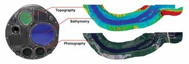
How the hydrographic sector is heading towards more autonomous solutions
By Wim van Wegen, head of content, Hydro International
As ocean science and technology professionals gather at Ocean Business 2025, the hydrographic surveying industry finds itself at an exciting juncture. Bathymetric data, once a niche market, now increasingly forms a cornerstone for industries planning sustainable marine spaces, enhancing navigation and protecting biodiversity. This shift places hydrography at the heart of global efforts towards sustainability and resilience. As the profession evolves, selecting the right equipment and building the right strategy to maximize its potential are crucial to navigating future challenges and opportunities. This article explores how these factors are shaping the industry’s path forward.
For those attending trade fairs and conferences in the hydrographic sector and related fields, the rise of autonomous solutions is unmistakable. The key question is: who has access to these technologies? Also, how do these solutions compare to traditional survey methods, and how can they be integrated effectively? Moreover: the cost of uncrewed vessels can be substantial, raising concerns about affordability and return on investment (ROI).
Towards more autonomy
Zooming further in on what we can witness at events such as Ocean Business, Oceanology International and many more, autonomous survey vessels are set to redefine routine data collection in hydrographic surveying. Uncrewed surface vessels (USVs) and autonomous underwater vehicles (AUVs) will increasingly take the lead, venturing into remote or hazardous areas that were previously inaccessible. This expansion not only broadens our survey capabilities but also ensures comprehensive coverage of diverse terrains. The Seabed 2030 project serves as a fantastic example where much of this comes together. This fascinating endeavour, launched in 2017, began with just 6% of the global ocean floor mapped to modern standards. Since
then, the Nippon Foundation-GEBCO Seabed 2030 Project has made remarkable progress, and by World Hydrography Day 2024 that figure had grown to 26.1%. This significant leap brings us closer to the ambitious goal of mapping the entire ocean floor by 2030, highlighting the endeavour’s pivotal role in uncovering the mysteries of the deep and transforming our understanding of the planet’s vast, uncharted waters.
This exciting pioneering project would not have been possible without the progress in automation; advancements that are seemingly taking place almost as we speak. As automation advances, real-time data processing will become integral to our operations. This capability allows for immediate quality control and decisionmaking, giving surveyors the possibility to respond swiftly to findings and adapt their strategies on the fly. The integration of
Map depicting the parts of the ocean floor that have been mapped. Shaded blue areas show the regions considered captured in the 2024 GEBCO Grid release. (Image courtesy: Pauline Weatherall, Seabed 2030 Global Center)
machine learning and AI further enhances our analytical prowess, with complex algorithms refining data interpretation and feature extraction. These technological strides promise more accurate and insightful results, driving innovation in many fields.
The future of survey operations – and therefore of the solutions they need – is marked by a shift towards remote control and monitoring. The rise of underwater drones brings many advantages. For example, they work with a limited footprint, require fewer people to operate and have a smaller impact on the environment. What should not be overlooked is that autonomous does not however mean uncrewed, because experts are still needed on board a mothership or onshore to monitor the process. Nevertheless, this evolution reduces the need for on-site personnel, enhancing both efficiency and safety. By leveraging remote operations, maintaining high standards of data collection while minimizing risks can be realized, paving the way for a new era in hydrographic surveying.
Of course, all of this needs an infrastructure to make this ecosystem work. The connection and the speed at which data can be processed is a hurdle that must be taken. Uncrewed systems and improved global, high-speed communications networks, such as Starlink or equivalent, will dramatically advance the ability to conduct autonomous, remote survey operations. Developments in this area are moving quickly, but there is still much to be done to make autonomous solutions a mainstream option optimally equipped for its task.
What is needed?
An issue that might capture the attention of manufacturers of hydrographic hardware and software solutions is the areas of investment that are expected to see the most significant growth in the coming years. Experts see robotics and autonomous systems as crucial to the future of the hydrographic sector, with uncrewed systems following closely behind. Another major area of interest is machine learning and artificial intelligence, increasingly considered to be key to advancing the industry. On top of this, real-time processing continues to be a vital consideration, as are UAV-based bathymetric Lidar and satellite bathymetry, which are seen as
essential tools for many hydrographic projects. Before coming to the conclusion that it is all about uncrewed, it should be noted that airborne Lidar bathymetry is receiving more and more attention from hydrographers and their colleagues in adjacent fields.
The trends pictured above reflect the sector’s commitment to technological innovation and automation, which are key to shaping its future landscape. For survey companies and government bodies, the tools they need most are those that enhance data collection and processing capabilities, especially as the demand for faster, more accurate results increases. As the sector moves towards greater automation, the challenge becomes ensuring that these tools are not only cutting-edge but also adaptable to evolving regulatory frameworks and operational requirements.
Investment in new technologies versus investment in skilled personnel is a topic of ongoing debate. While growth in the sector is currently strong, there are questions about its sustainability, particularly as the industry faces pressures in the operational and maintenance phases. However, once regulations for autonomous vessels are established, this could further shape the market, potentially affecting human capital and influencing the future growth of the business. For manufacturers of these solutions, this insight is invaluable. Understanding the specific needs of surveyors, researchers and government entities can help better tailor their products to the evolving demands of the hydrographic sector. With increasing data resolution requirements, a growing number of projects and a shortage of skilled personnel, the demand for automation and AI is clear. These technologies can help focus personnel on critical tasks rather than repetitive manual processes, enhancing overall efficiency and accuracy.
This shift towards automation and autonomy will make certain skills essential for professionals. With modern equipment collecting data at high frequencies and multiple systems working simultaneously (e.g. MBES, magnetometers, Lidar), operators face the challenge of managing it all. Given the rapid voluminous data flow, it is
here is an example of sensor integration. Equipped with
and
the Schiebel Camcopter S-100 UAS offers valuable capabilities for a range of underwater survey applications. The integrated laser scanners support both bathymetric mapping (up to 3.5 Secchi depth) and topographic mapping, applicable to both underwater and surface environments. (Image courtesy: Schiebel Group)
The Fugro Vaquita 12-metre Blue Essence uncrewed surface vessel. (Image courtesy: Fugro)
Depicted
RIEGL’s VQ-860-G
VUX-120,
The result of mapping with combined devices and payloads, showing a hybrid bathymetric model from USV and UAV data. (Image courtesy: Maritime University of Szczecin, Poland)
nearly impossible for operators to adjust settings in real time. Automation can step in to handle these adjustments – think of MBES tracker systems or mathematical data filters. Operators will need to learn both the practical and theoretical aspects of automation processes, drawing on the knowledge of experienced colleagues and field experience.
A recurring theme in the annual Hydro International industry survey is the call for a single, comprehensive survey instrument for hydrographic surveys. This all-in-one solution would map all necessary parameters in one operation, eliminating the need for multiple pieces of equipment such as echosounders, side-scan sonars, boomers, pingers and magnetometers. The ideal design would integrate all these tools into one robust instrument, streamlining the data acquisition process and reducing the need to switch between various devices. For smaller companies in particular, this would be an ideal scenario. As one industry professional noted: “I would expect the equipment to be designed as a unified instrument, combining all necessary tools into one.”
Things to consider
In the most recent version of the industry survey, a hydrographer working for a survey division in a marine construction company pointed out that the price of bathymetric and hydrographic survey equipment is high,
making it difficult to convince management to invest in it. For many hydrographic survey companies, especially smaller ones, the initial investment required for USV and AUV technologies can be significant, and they may struggle to justify the cost, particularly when working on smaller-scale projects. Beyond the financial investment, there are also operational hurdles, such as the need to upskill staff and integrate these technologies into existing workflows. Maintenance, support and troubleshooting of uncrewed systems also require specialized knowledge, which may add extra complexity to the day-to-day operations. For smaller companies, navigating these challenges while ensuring a solid ROI is a critical consideration as they look to incorporate these innovative solutions into their services.
Resistance to innovation (clients want to continue using traditional methodologies) is also a challenge faced in the sector. Perhaps this should be regarded as a sign that it is necessary to participate more in scientific events and promote this knowledge in institutions, as well as giving direction to the hydrographic community. Knowledge sharing is key here.
Technological developments have resulted in highly superior data capture solutions, which has opened the door to many new possibilities and applications. However, this also poses a challenge. Since the resolution
of data has increased dramatically, the amount of data has grown accordingly and charting it takes a lot of time. Many of those involved in mapping the hydrographic and marine environment are struggling with this.
While work processes are changing towards more remote, more autonomous and more data, much is still unclear to many involved in the business, making strategies very hard. It certainly is true that the innovations are allowing companies to increase efficiency and safety while enhancing the accuracy of their data collection, and it poses major benefits as for example USVs and AUVs can reach challenging and remote locations, reducing the need for crewed vessels and lowering operational costs in the process. Also, for service providers, this shift is not just about embracing new technology; it is about staying competitive in an evolving market. The ability to offer more detailed and reliable bathymetric data can open opportunities across various sectors, from offshore energy and coastal development to maritime navigation. These technologies are positioning surveyors as essential contributors to industries that are heavily reliant on accurate, real-time data. Yes, lots of advantages indeed.
Looking ahead, the question many service providers are grappling with is which market sectors will yield the highest ROI over the next five years. Offshore energy, with its
growing demand for precise data to support renewable energy projects such as wind farms, is one area where the ROI is expected to be significant. Additionally, coastal development projects and efforts to improve maritime navigation are driving demand for advanced surveying capabilities. As these sectors continue to grow, the value of incorporating USVs and AUVs into the surveying process becomes increasingly clear.
In addition to the uncrewed vehicles themselves, selecting the right sensors to mount on USVs and AUVs is another crucial decision for survey service providers. Sensors such as multibeam echosounders, side-scan sonar and to a growing extent Lidar are often used to capture detailed bathymetric data, but the cost and complexity of these sensors can vary greatly. Guidance is much needed here, as Hydro International knows from the many comments gathered by its annual industry survey. Smaller survey companies may face difficulty in choosing the right equipment for their specific needs, as the latest, high-end sensors can be expensive and not necessarily a great fit for every project. Also, integrating those sensors with autonomous vessels requires technical expertise to ensure compatibility and optimal performance. Deciding on the right balance between highly sophisticated technology and cost-effective solutions is a challenge that should not be underestimated, especially for smaller companies with tight budgets and limited resources. Properly weighing these factors is essential for maximizing the ROI, while maintaining the quality of the data collected.
Capitalizing the potential
As we have just read, the hydrographic sector is increasingly recognizing the value of remote and autonomous operations, embracing new approaches to survey operations that meet industry standards while breaking from traditional methods. Overall, there is an optimistic outlook regarding the high-tech transformation within the sector. Automation is undeniably valuable with AI serving as a key enabler for the rapid collection of large volumes of data in a short time. However, there are limits to its capabilities. To overcome these limitations, we need professionals who can translate their vision into code. As one respondent in the latest edition of the Hydro International
About the author
Wim van Wegen is head of content at GIM International and Hydro International. In his role, he is responsible for the print and online publications of one of the world’s leading geomatics and hydrography trade media brands. He is also a contributor of columns and feature articles, and often interviews renowned experts in the geospatial industry. Van Wegen has a bachelor degree in European studies from the NHL University of Applied Sciences in Leeuwarden, the Netherlands.
industry survey stated: “In my opinion, in the age of AI, visionaries are needed who go beyond being just consumers of tools.”
While automation brings efficiency, it also creates a gap in understanding the underlying processes. As more tasks become automated, fewer people grasp the intricacies of data acquisition and processing, leaving them unaware of how adjustments in settings can influence results. This highlights the continued importance of maintaining foundational skills in the field.
The hydrographic surveying industry is undergoing significant transformation, fuelled by the growing use of remote-controlled and autonomous units that operate across air, water and underwater environments. These units, acting as instrument carriers, offer remarkable cost efficiency and are driving advancements in sensor technology miniaturization and energy optimization. Digitalization is reshaping hydrographic processes, from cutting-edge sensor technology to the efficient collection, transmission, processing and dissemination of hydrographic data. Despite the hurdles still to be taken, as mentioned earlier, this digital shift is poised to generate data volumes of unprecedented breadth and quality.
However, to fully capitalize on this potential, the industry requires a comprehensive digital ecosystem. This system must be capable of integrating diverse marine data and ensuring the sovereign and sustainable management of these extensive data repositories. Platforms that offer a comprehensive overview of the available equipment and software are essential to navigating this evolving landscape.
Geo-matching is a product comparison platform that provides a vast database of all the products, whether hardware or software, that are part of this ecosystem. It is safe to say that this platform also serves as a part of the ecosystem, as it offers the most comprehensive overview of equipment, instruments and software for the geospatial industry.
The digital shift is set to generate data volumes of unparalleled scope and quality. Shown here: MBARI researchers conducted high-resolution, low-altitude surveys of a section of the canyon floor located deep beneath Monterey Bay. This area hosts one of the largest submarine canyons on the west coast of North America. (Image courtesy: Monica WolfsonSchwehr/MBARI)
Bridging the gap with Develogic’s holistic end-to-end solutions
Devologic is a leading innovator in subsea technology, specializing in system integration for hydrography and marine surveying. Its solutions connect data acquisition, real-time processing and cloud-based management, delivering advanced capabilities for underwater communication, autonomous navigation and big data. With expertise in acoustic and optical communication, the company ensures precision, efficiency and reliability in even the most demanding underwater environments. In this Q&A, Ole Johannsen, managing director at Devologic, shares insights into the latest industry trends and how its technology is shaping the future of marine surveying.
From your perspective, what are the trends and developments to watch in the hydrographic and marine surveying industry?
The hydrographic and marine surveying industry is evolving rapidly, driven by technological advancements and growing environmental concerns. Some key trends and developments are autonomous and remote technology, subsea Lidar, real-time data processing, AI classification of data, secured clouds for big data management and standardization for interoperability for advanced underwater networks.
In a nutshell, the marine surveying industry is moving towards autonomous, data-driven and environmentally conscious approaches. As technology continues to advance, the industry is not only improving the accuracy and efficiency of surveys but also expanding the range of applications – from deep-sea exploration to environmental monitoring and offshore infrastructure management. These innovations will play a crucial role in the sustainable use of the oceans, resource management and environmental protection.
How is your company contributing to providing the right equipment for a hydrographer’s and marine surveyor’s toolkit?
As a company specializing in subsea technology, we make significant contributions by providing advanced, reliable equipment designed for underwater data acquisition, processing, transmission and management for deep-sea applications. We support professionals by understanding their unique use cases and tailoring solutions to their specific applications.
We offer a complete end-to-end process, from data collection to data management, all from a single source. Our product range includes innovations such as our acoustic recorder and acoustic and optical modems, which ensure the optimal performance of our lander systems or can be used as standalone solutions. We also offer a diversified portfolio of technology through our technology partners that includes HF radar, seismic monitoring, autonomous and waypoint navigation, subsea energy management systems, optical time domain reflectometry, secured cloud-based big data management and data classification.
This combination of standard products, system integration services and our technology consulting delivers clear benefits to our clients. In a nutshell, our strong collaboration attitude and our deep expertise in system integration combined with extensive knowledge of software and hardware ensures the perfect fit for our customers.
Which aspect of your company’s contribution to the hydrographic and marine sector – and adjacent fields – are you most proud of?
Our proudest contribution lies in our ability to provide holistic, endto-end solutions that bridge the gap between data acquisition, realtime processing and data management. Many players in the market provide hardware or software, but our strength is in integrating both seamlessly, giving clients the ability to go from data collection to actionable insights, all from a single, reliable source.
Additionally, our system integration expertise stands out. We don’t just supply off-the-shelf products; we deeply engage with
our clients to understand their specific challenges and craft tailored solutions. Whether it’s optimizing the performance of subsea lander systems or developing new products such as our sonar transponder with inductive modem, we focus on ensuring that everything works together to maximize efficiency, reliability and performance.
In adjacent fields, such as oceanographic research or environmental monitoring, we are proud of our role in data-driven sustainability. By providing reliable tools for accurate, real-time data collection, we help researchers, conservationists and industry professionals to better understand the marine environment. This is a direct contribution to ensuring the long-term health of marine ecosystems and supporting the sustainable use of marine resources.
We are proud of the integrity and reliability of our systems and the trust we build with our customers. Every project, whether in marine surveying, offshore energy or environmental monitoring, is an opportunity for us to make a positive contribution to the industry and the world.
How do your products differentiate themselves from other solutions available in the market, and have any
About the author
Ole Johannsen is managing director at Develogic Subsea Technology, with 20 years of experience in providing maritime customers with the equipment they need and access to ocean data. Ole uses that experience and his focus on consistency, transparency and clarity to build long-lasting relationships with his customers.
noteworthy advancements been made in recent versions?
Our products stand out because they offer a fully integrated, customizable and highly reliable solution that combines the best of hardware, software and system integration. Through continuous innovation – whether in real-time processing, enhanced communication technologies or data analysis capabilities – we ensure that our clients receive cutting-edge tools that meet the demands of the ever-evolving marine and hydrographic industries. Moreover, our deep understanding of our clients’ unique needs allows us to deliver solutions that truly add value, whether through improved efficiency or sustainability or advanced data accuracy.
Our acoustic modems and recorders, for example, are built with advanced signal processing that allows for high-
speed, high-reliability communication over long distances. This is particularly critical in environments where current communication methods are ineffective, for instance in deep water. We have continually enhanced the range, data throughput and power efficiency of these devices to ensure that they meet the evolving demands of the market.
Another significant advancement is the improved compatibility of our products with other industry-standard systems and oceanographic data platforms. This ease of integration saves time, reduces manual errors and provides a more efficient workflow for clients. Additionally, the cloud-based data management solutions we offer through our partner North.io allow for real-time sharing and access to subsea data from any location, further simplifying operations.
We enable our customers to use our oceans sustainably and safe…
…by collecting, processing, transferring, and managing ocean data for our customers.
Making Ocean Data available with us
Research vessel innovation & equipment: the Dutch way
By WIm van Wegen, head of content, Hydro International
As a Dutchman, it is not entirely surprising that I mainly encounter hydrography, ocean sciences, marine engineering and the equipment that goes with them in the Netherlands. Of course, Geo-matching is aimed at a global audience, but that does not make it any less interesting to provide some perspective on the state of affairs when it comes to collecting data and what is needed for that based on my Dutch experiences. This brings me to two Dutch islands, one of which no longer exists.
The island of Texel
A little over a year ago I was on Texel, one of the Dutch Wadden Islands. I was there at the invitation of the NIOZ Royal Netherlands Institute for Sea Research, the national oceanographic institute and the Netherlands’ centre of expertise for ocean, sea and coast. The reason for the invitation was the christening of the Wim Wolff, a solemn moment. The RV Wim Wolff charts a new course as the successor to the Navicula. At 37 metres long, this research vessel is built for operations in the Wadden Sea, the Delta region and the near-coastal waters of the North Sea. This brand new state-of-the-art ship is part of the replacement operation
of the country’s research fleet. As an editor active in the hydrographic sector, I was especially curious about the equipment that you can hang on the new ship as, in addition to oceanographic research, the ship can also be equipped with hydrographic sensors.
The Wim Wolff has a dynamic positioning (DP) system. With a draft of just one metre and a flat bottom for beaching, the ship operates in the shallow waters of the Wadden Sea and Zeeland delta but can also sail up to 20 miles offshore along the Danish, German, Dutch and Belgian coasts. On board are wet and dry laboratories, space for lab containers on the 125m² working deck and accommodation for
four crew members and 12 researchers. In the summer of 2024, the ship set off on its first expedition: the SIBES project.
The flagship of the Dutch research fleet will be the RV Anna Weber-van Bosse, which is due to be ready for use by the end of this year. “We started assembling the equipment for the Anna Weber-van Bosse more than five years ago,” Gert-Jan Reichart, responsible for the scientific side of the project, told Hydro International last year. “That started with consultation rounds at the various universities that will use the ship, since it is a national facility of the Netherlands. The key question we asked all potential stakeholders was: what do you need? Based on that, the specifications were drawn up, which resulted in, among other things, a foremast with all kinds of equipment for atmospheric measurements and the largest possible aft deck to accommodate all kinds of third-party equipment. In this way, we have tried to make
Project Octopus’ multifunctional design supports tasks beyond fishing, including marine data collection, diving, drone and USV/ROV operations. (Image courtesy: Padmos)
The RV Anna Weber-van Bosse was too large to fully fit inside the shipyard’s assembly hall, requiring parts such as the bridge to be constructed separately outdoors in the coming months. (Image courtesy: NIOZ)
the Wadden Sea. (Image courtesy: Thecla Bodewes Shipyards)
the ship as widely applicable as possible.” This gives a good idea of the years-long process around the purchase of the equipment that precedes such a large project.
In the same interview, Reichart explained: “We are also working on renewing equipment such as AUVs, ROVs and gliders. There is sufficient space on the new flagship for this type of larger equipment, and that was quite a challenge because, compared to the huge research ships owned by France and Germany, we want to limit our ship to a maximum of 80 metres, to ensure her flexibility in coastal areas as well as the open seas. As a result, we had to build as efficiently as possible. We also work a lot with the container concept. These containers are all designed with a specific purpose, such as measuring traces of oxygen in bottom water or traces of methane in seawater. In fact, they are laboratories that can be changed per expedition, depending on requirements. The ship itself has very few laboratories, but is modular.”
The fixed gondola plays a crucial role in the integration of advanced sensors on board. To be able to conduct research under as many conditions as possible, a wide weather window is essential. This also applies to current research in the North Atlantic Ocean, where the most severe weather conditions are scientifically most relevant. Although gliders and other unmanned methods can do a lot of work, it is sometimes simply necessary to be on location yourself.
The former island of Urk
From the island of Texel we move to a former island. Urk, once an island in the Zuiderzee – a shallow bay of the North Sea in the northwest of the Netherlands, now known as the IJsselmeer – lost its island status with the construction of the Afsluitdijk and the draining of the Noordoostpolder. From an isolated community it changed into a town that had to reinvent itself, without losing its strong maritime identity. The fishing industry, the backbone of Urk for centuries, moves with the times and continues to innovate, from traditional cutters to sustainable and technologically advanced fishing methods.
About the author
Wim van Wegen is head of content at GIM International and Hydro International. In his role, he is responsible for the print and online publications of one of the world’s leading geomatics and hydrography trade media brands.
Amidst the hurdles the fishing sector must take, fisherman Jacob Brands is charting a new course with ‘Project Octopus’ – an initiative that aims to transform the fishing industry in the Netherlands but that also holds promise for marine researchers such as hydrographers By integrating advanced technology and innovative approaches, Project Octopus could serve as a valuable platform for exploring underwater environments, conducting detailed underwater mapping and fostering collaboration between fishermen and the scientific community. It focuses on a groundbreaking cutter vessel that combines sustainability and versatility. This 32-metre ship can transition from fishing to research within days, driving innovation in sustainable fishing. Advanced onboard systems collect and share data, enabling smarter, adaptive operations that align catches with real-time demand. However, its multifunctional design also allows for marine data collection, underwater inspections, seaweed harvesting, and the operation of uncrewed surface vehicles (USVs), remotely operated vehicles (ROVs), and autonomous underwater vehicles (AUVs). The ship’s modular approach to equipment installation is one of its standout features: instead of permanent fixtures, specialized equipment is stored in containers tailored to each mission. These containers are seamlessly integrated into the vessel through strategically placed power and data plug-ins, offering flexibility for a variety of assignments.
The ship is also equipped with energy transfer options, enabling the testing of alternative fuel solutions, and includes an A-frame for launching AUVs. Plans are underway to incorporate a moon pool for additional functionality. For precise navigation during operations, Project Octopus features DP capabilities, designed to be modular for adaptability. Despite its compact size, the vessel will offer expanded accommodation and control rooms for both on-site and remote operations, ensuring a high degree of operational flexibility across different missions.
What I find intriguing is that hydrography is so close by, while many people are completely unaware of it or have never even heard of it. But exploring our seas is of course something that really appeals to the imagination, and even has something magical about it. While I admit that I may be slightly biased, the Netherlands has built a strong reputation in mastering the sea and mapping the underwater world. It is truly exciting to see a completely renewed research fleet on the horizon, with pioneers from sectors such as fisheries leading the way in merging industries, all with sustainability at the core. This is also the great thing about visiting an event such as Ocean Business, where you see all those innovations brought together – including demos in the dock. It doesn’t get much more inspiring: all that equipment that demystifies the underwater world a bit, making it tangible!
This photo captures the launch of the research vessel Wim Wolff, built by Thecla Bodewes Shipyards in Harlingen, a Frisian town along
Charting new waters with RIEGL Lidar technology
As bathymetric Lidar business division manager at RIEGL, Ursula Riegl plays a key role in advancing hydrographic surveying technology. She was happy to share her insights on the latest trends shaping the industry, from UAV-based data collection to AI-enhanced processing. In this Q&A, she discusses how RIEGL’s innovative Lidar systems are meeting the growing demand for highresolution, flexible and efficient hydrographic surveying solutions, while also addressing challenges such as environmental monitoring, data processing efficiency and the need for seamless system integration.
From your perspective, what are the trends and developments to watch in the hydrographic and marine surveying industry?
The hydrographic sector is particularly active at present, as seen in numerous related events, customer demands and research projects, as well as the increase in dedicated equipment and emerging applications.
The importance of surveying in the hydrographic and marine context is not new, but awareness has intensified in recent years, stirred by an alertness regarding environmental changes due to global warming. As RIEGL provides Lidar systems for survey in the land-water transition zone, we are directly concerned by demands focusing on monitoring changes in this dynamic area.
The urgency comes hand in hand with the need for detailed, repeated surveys of critical areas. The trend of UAV-based survey, that has revolutionized the surveying industry over the last decade, is equally observable
in the hydrographic context: both airborne drones and remotely operated vehicles on or beneath the water surface require tailored equipment. The demand for faster availability of results is a recurring topic that concerns both data transmission and processing tools, as is AI-enhanced tasks such as data classification.
How is your company contributing to providing the right equipment for a hydrographer’s and marine surveyor’s toolkit?
RIEGL provides topobathymetric Lidar systems to serve the needs of different applications: for example, in the UAV sector, payload weight and size are limiting factors. The restrictions are less rigorous for integration into helicopters or fixed-wing planes, yet compactness always facilitates integration. Another aspect that we take care of is to provide operational flexibility by offering a choice of measurement modes and system parameters. This enables operation in a large envelope of flight altitudes from very low up to several hundred metres, focusing on maximum productivity, highest point density or maximum depth penetration. Apart from our dedicated systems for bathymetry, we offer solutions for other related tasks, such as boatbased mobile Lidar systems or airborne and UAV-borne topographic Lidar systems that can be used to complement the hydrographic survey by high-resolution capture of the features on shore.
We also put effort into providing streamlined data processing workflows and quality verification tools.
Which aspect of your company’s contribution to the hydrographic and marine sector – and adjacent fields – are you most proud of?
I think our developers and engineers, responsible for the development of our topobathymetric products since the introduction of our first dedicated system in 2011, have good reason to be proud of their achievements both in hardware design and signal processing, and of their contributions to the scientific community. This is the basis of our present position among the established providers of bathymetric Lidar. Our current product developments therefore rely on longstanding experience and research, while at the same time being driven by a constant spirit of innovation. My personal answer would be that I feel fortunate to work with this team: there is a
Detailed survey of coastal underwater topography.
UAV-based use of VQ-840-GE topobathymetric Lidar in harbour environment.
passionate readiness to experiment and try out even unconventional approaches, and a high focus on providing robust, reliable solutions – which is what our customers expect from us.
About the author
Ursula Riegl is bathymetric Lidar business division manager at RIEGL Laser Measurement Systems. RIEGL is an Austriabased manufacturer of Lidar systems for airborne, UAVborne and terrestrial static and kinematic applications. For the hydrographic context, the company provides airborne systems for topobathymetric tasks as well as kinematic systems for boat-based topographic survey of the shoreline.
How do your products differentiate themselves from other solutions available in the market, and have any noteworthy advancements been made in recent versions?
Currently, our focus lies on providing compact, powerful systems based on stateof-the-art full-waveform technology that is particularly suited for UAV integration. In constant exchange with our customers and academic institutions, we define specific needs and scrutinize quality and performance aptitude to fine-tune our system design. Therefore, we offer an increasing range of bathymetric solutions and dedicated processing options for various
use cases. This allows us to recommend the best-fitting system for a variety of contexts, such as coastal mapping, hydro engineering or hydro archaeology and defence applications.
My personal highlights in recent years were the introduction of the first compact bathymetric Lidar system for UAV-borne applications, the RIEGL VQ-840-G in 2018, followed by even more lightweight models, and last year’s presentation of the highperformance version RIEGL VQ-860-G, for which we continue to explore its enormous potential.
In this Q&A, Iain Slade, innovation and product manager at Teledyne Valeport, offers a deeper look into the dynamic trends shaping hydrography and marine surveying. As automation, over-the-horizon operations and machine learning redefine the industry, Iain highlights Teledyne Valeport’s pivotal role in driving these advancements. He discusses how the company’s cutting-edge solutions, such as the SWiFT range with Bluetooth integration, are enhancing operational efficiency, enabling long-duration autonomous operations and pushing the boundaries of sensor technology to meet the evolving needs of hydrographers worldwide.
From your perspective, what are the trends and developments to watch in the hydrographic and marine surveying industry?
The main developments are the rapid adoption of automation for marine measurements, including over-the-horizon operations, and the use of machine learning, for example for collision avoidance.
USVs are being designed for longer duration/distance deployments, while submersible vessels are moving towards long-term subsea residency (being stationed underwater for significant lengths of time of six months or more), so automation is key! This is across all areas, from monitoring to biofoul-mitigation solutions, to the charging of battery-powered instruments without human intervention.
Other trends include the move towards automatic integration, overthe-air updates to systems (preventing the need for vehicles to return to shore for updates to instrumentation firmware, etc.) and closer coupling between instruments/systems.
How is your company contributing to providing the right equipment for a hydrographer’s and marine surveyor’s toolkit?
We do this by working closely with partners and third parties, listening to the voice of the customer and improving the individual products’ functionality – including adding new features to serve specific hydrographic markets and ensuring smooth compatibility with hydrographic survey software.
At the same time as working with other companies within the industry, Teledyne Valeport is also working more closely with its sister companies within the Teledyne Marine group, focusing on offering all-in-one solutions for hydrography.
Which aspect of your company’s contribution to the hydrographic and marine sector – and adjacent fields – are you most proud of?
At Teledyne Valeport, I take great pride in our commitment to promoting marine science and technology education and training. We actively engage with local schools, colleges and universities for careers fairs and careers talks. Beyond education, our participation in key industry organizations such as The Hydrographic Society UK and Ireland and their events, the Society of Maritime Industries (SMI) and the Society for Underwater Technology (SUT) and our contribution to International Hydrographic Organization working groups allow us to contribute to the wider marine community.
I am also incredibly proud of Teledyne Valeport’s long-standing reputation. We are known for manufacturing trusted products that have been providing the hydrographic community with high-quality, accurate and reliable data for over 50 years. The fact that some of our longest-running products remain so popular is incredible, and a testament to the original design philosophy of the products.
How do your products differentiate themselves from other solutions available in the market, and have any noteworthy advancements been made in recent versions?
Our SWiFT range stands out in the market due to its seamless integration of Bluetooth wireless technology (Bluetooth is also used in several of our other products), enabling hands-free data transfer, onboard vessels or on uncrewed vehicles. This capability not only enhances operational efficiency, but also supports real-time decision-making in the field. To optimize performance for long
About the author
deployments, we have implemented Bluetooth sleep modes to conserve power, ensuring the products are compatible with the longer range/ duration USVs.
Iain Slade, Teledyne Valeport innovation and product manager, has over 20 years of experience as an accredited hydrographic professional working in a range of sectors including civil hydrography, marine renewables, coastal monitoring and offshore oil and gas. Iain has an established international reputation within the hydrographic community.
We recently added two new modes – fast continuous (up to 16Hz sampling) and ELViS (elevation limited vertical sampling). ELViS mode is of particular interest to the Japanese hydrographic market, allowing simultaneous down- and up-cast data to be recorded, based on a set trigger depth.
SWiFT SVP
Additionally, we have been collaborating with smart winch manufacturers to ensure smooth operation between winch and SWiFT instruments, further enabling autonomous, hands-free operations.
New Teldyne Valeport Ocean software features available
• Fast Continuous Mode: Start logging data at 16 Hz with no need for pressure triggers
• ELViS Profiling Mode: Elevation Limited Vertical Sampling - combined up and down casts, triggered by pressure, ensuring precise data logging.
SBG Systems unveils major enhancement for Ellipse sensors
SBG Systems has introduced the latest iteration of its Ellipse product line. The New Ellipse, available as a no-cost firmware upgrade for both AHRS and INS configurations, enhances the accuracy, reliability and versatility of the existing hardware. This update positions the system to meet the evolving demands of complex and high-performance applications. SBG Systems is a prominent provider of MEMS-based inertial motion sensing solutions. The New Ellipse is presented as a new step in precision and reliability. The latest-generation sensor fusion algorithm enhances navigation, attitude and heave performance, ensuring precise and stable positioning even in dynamic environments and challenging conditions. In addition, the New Ellipse introduces advanced GNSS-denied capabilities. It features newly integrated flags that trigger when GNSS jamming or spoofing threats are detected and allows users to reject or re-enable external sensors – such as GNSS – without needing to reset the filter. This gives enhanced visibility and control over how the system responds to these events, allowing for more precise adjustments in challenging environments.
First Antarctica expedition of Schmidt Ocean Institute successfully completed
Schmidt Ocean Institute’s research vessel Falkor (too) has marked a major milestone with the completion of its first Antarctic science expedition. After a year of meticulous preparations, both the ship and crew embarked on a threeweek journey, navigating the region’s challenging conditions to conduct groundbreaking research. The mission pushed the boundaries of scientific exploration while fine-tuning operational strategies for future voyages. “Operating our ship in the Southern Ocean marks a significant milestone in Schmidt Ocean Institute’s history,” said Eric King, senior director of maritime infrastructure. “RV Falkor (too) performed exceptionally well, our crew gained tremendous knowledge and experience, and the expedition prepared us well for future explorations around this part of the global ocean in the coming decade.” RV Falkor (too) is a certified Class C polar vessel, which means it is capable of operating in austral summer when there is light sea ice.
Teledyne Geospatial introduces Fathom for efficient coastal mapping
Teledyne Geospatial has announced the launch of Fathom, marking a new stride in the development of fast and intuitive coastal mapping solutions. The comprehensive system integrates topo Lidar, bathy Lidar and a multispectral camera, making it possible to capture the entire coastal scene – from dry land to the underwater depths. This holistic approach enables the thorough documentation of every aspect of the coastline. Fathom is designed with the purpose of overcoming common challenges related to the cost and technical complexity of topobathymetric surveys, by leveraging Optech’s advancements in sensor miniaturization, real-time processing and production workflow acceleration. The new solution was developed in response to feedback from government and engineering organizations, which identified that crucial geospatial data is missing for the management of resources and infrastructure on land, the intertidal zone and the seafloor. For hydrographers, Fathom fills the crucial gap between land and water, offering an exceptional solution for mapping the coastal interface. Complementing acoustic surveys, it delivers detailed, high-quality data over the coastline.
Fathom collects data efficiently using real-time quality control with Onboard and scalable processing through a CARIS workflow. (Image courtesy: Teledyne Geospatial)
The Ellipse-D combines an IMU with an internal dual-band, quadconstellation GNSS receiver and advanced sensor fusion, delivering precise positioning and orientation in challenging environments. (Image courtesy: SBG Systems)
RV Falkor (too) navigated Antarctic icebergs on its first science expedition, conducting eight ROV SuBastian dives, sea ice operations and seafloor mapping. Ice pilots and crew transported scientists by small boat to sites such as Joinville Island for marine mammal and seabird research. (Image courtesy: Mónika Naranjo-Shepherd)
VLF Transducer
Bandwidths from 10Hz—1000HZ<
620D 18”Dual Source
Acousc Current Meters
Wave Heights & Stats
Tide w/solar power
The AquaPulseTM Family of Acousc systems are versale subboom sediment profiling sources, generang repeatable low frequency acousc pulses for 2D &3D UHR surveys, and academic research. The output signal wavelets are precise and stable over millions of shots.