
| Architecture | Urban Conservation | Gaurish Deshpande selected works 2020 - 2022 P O RTF O LI O

| Architecture | Urban Conservation | Gaurish Deshpande +91 - 8975610681 | gaurishdeshpande2123@gmail.com

| Education | Work experience Freelance projects 2020-2022Kolhapur | Beri2019-2020PuneEco-SolutionsArchitectpvt.ltd.|GreenArchitectArchitectsandEngineers pvt. ltd. Srujan2018Kolhapur|Internresearch and planning foundation 2017Pune | Summer internship Vijay Sahadev Architects 2016Latur| Summer internship Navkar Architects 2015Pune | Summer internship Masters in urban conservation | K.R.V.I.A. Mumbai University Of Mumbai Bachelor of architecture | B.K.P.S. C.O.A. Pune Savitribai Phule Pune University |IntermediateS.M.Lohiajr. college Kolhapur H.S.C. Syllabus High school | Seventh Day Adventist Higher secondary school, Kolhapur I.C.S.E. Syllabus 2002-20122012-20142014-20192020-2022
graphics credentials note - all contents are produced by author unless specified otherwise. 01 080204 0506 07 03 workProfessionalworkAcademic

OtherprojectArchitecturalconservationForturbanHistoricconservationArchitecturalcoresworks 535149453733251701|Contents090807060504030201
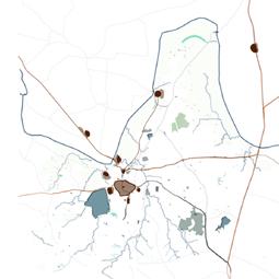
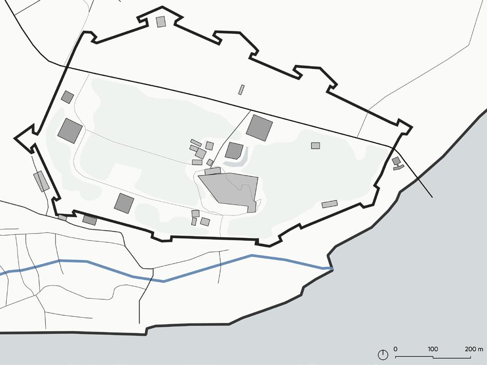
Historic core of Kolhapur
The historic urban areas of Indian cities are experiencing higher gentrification and urbanization pressures causing rapid urban transformations. The tansforming natural resources and traditional livelihood patterns of these historic areas are compromised in the planning processes. The increasing insensitive urban redevelopments is hampering the built character resulting in the cultural disintegration.
Urbanization, cultural dimension, cultural integrities, historic urban landscape, sustainable conservation, community resilience and interlinked social structures.
There is an utmost need to integrate the cultural dimension in the sustainable development process of such historic areas by utilizing the social, economic and environmental identities of the city. This thesis intends to explore the workability of a dynamic concept of cultural integrities which can precisely cover the larger context of the cultural dimension in sustainable development of a city.
This study elaborates on the UNESCO’s recommendation on Historic Urban Landscape framework (2011) applicable for historic cities. It highlights the idea of extensive sustainable conservation of the transforming significant cultural heritage by evaluating, valuing and structuring the tangible and intangible cultural resources. This methodology can possibly strengthen the interlinked social structures and fundamental inter-relations between the nature - culture - people.
The significant historic core of Kolhapur city is chosen for this study which comprises of fortified town in the Karveer region and Shri Mahalakshmi temple as a significant pilgrimage centre which play an important role in establishing the unique cultural identities of the historic core.
1 urbanHistoriccores [Re]thinking the cultural integrities in historic urban center | Kolhapur city Project credits : Site location : About project : Keywords : Masters in urban conservation | Semester IV | 2022
Thesis project - [Re]thinking the cultural integrities in historic urban center Guide - Ar. Vikram Pawar, Ar. Apoorva Iyengar
01
2 Research question : Framework : Significant attributes : How can we effectively integrate the significant cultural identities and the collective cultural heritage in the sustainable conservation of historic urban center? Environmentaldimension SportsHeritage skylines New developments Karvir Sansthan Historic structures Traditional communities Culture Archaeologicalproductsdrivensitesinheritage coreFood andArtattires ChatrapatiUniversityShivaji dimensionSocial dimensionCultural identitiesCulturalPeopleDevelopmentSustainable Traditional communities Transforming natural resources Traditional livelihood patterns Cultural integritiesEconomicaldimension Festivals Historic lakes

| Regional terrain | Identification of significant cultural landscapes and the governance boundaries | Historical evolution 200 - 1300 A.D. | Early Hindu period 1300 - 1658 A.D. | Muslim period 1659 - 1838 A.D. | Maratha period | Physiography


4 1838 - 1947 A.D. | British period 1948 - 1990 A.D. | After independence 1990 - 2000 A.D. | During industrialisation 2000 - 2020 A.D. | Modern period | Identified historic layers in the core area


5 | Mapping significant heritage and vulnerabilities in historic core


6


7 |

8 |

9 |

10

11 | Community analysis and identifying vulnerabilities


12 | Community interventions | Scan for more


13 | Illustrating the loss of character along primary streets which comprise of cultural markets and traditional community engagements

14 | Contemporary structures | Community engagements | Heritage structures | Vulnerable traffic conditions

15 | Interventions along primary market streets

16


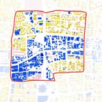
17 urbanHistoriccores Cultural resilience in the historic core of metro city | Pune city02 Project credits : Associated team : Role : Site location : About project : Keywords : Masters in urban conservation | Semester III Urban design studio -Local Area Planning in historic cores | 2021 Teaching staff -Ar. Aneerudha Paul, Ar. Vikram Pawar, Ar. Jamshid Bhiwandiwalla, Ar. Ketaki Tare, Ar. Sanaeya Vandrewala Urban conservation -Madhura Zamre, Rajeshwari Sawant, Krutika Rathod Urban design -Himanshu Deshpande, Anirudh Bhambure, Swapna Jadhav Team co-ordination, data collection, interviews of field experts, questionnaire surveys, GIS mapping, on-site field mapping, analysis issues and concerns, mapping vulnerabilities, executing structure plan, individual interventions.
Historic core of Pune
The diverse and vibrant traditional communities populate existing neighbourhoods in the core areas that are crucial to the local economy. They represent a variety of cultural identities adding up to a distinct character in these fast growing cities. These livelihoods must be involved in the integrated planning process seeking for resilience through sustainable development.
The potential attributes that represent the distinct character of the core along with their vulnerabilities due to the urban transformations, man made or natural disasters were studied in the significant Peths. They comprised of Kasba peth, Raviwar peth, and Budhwar peth. Local area planning, traditional communities, cultural identities, resilience, sustainable development.
The old core of Pune is not confined with any boundary wall, hence the first step was defining the extent of the study area. The study area is delineated according to the administrative divisions of the city which comprises of three wards Kasba peth, Bhavani peth and Vishrambaug ward.
18 Research question : Framework : Significant attributes : Cultural Resilience - How resilient are the traditional communities in historic core areas of Indian metro cities ? How can they be integrated in local area planning process using heritage as a significant tool ? Tangible heritage Intangible heritage Compromised public spaces around heritage Heritage walks and increasing mobility patterns Cultural ResilienceHeritagedevelopmentinclusiveLocal area plan Heritage graded structures Metro project from historic core Traditionalarea cultural markets facing developments pressures Loss of character Vulnerable livelihood patterns Heritage walks Invisible city

19 | Historical evolution | Delineating Peth boundaries in the historic core of Pune | Vulnerable transitional spaces in old peth areas | British rule 1890 - 1920 A.D.1820 A.D. | Maratha empire 1700 A.D. | Mughal sultanate 1650 A.D. 01. Somawar peth 02. Mangalwar peth 03. Budhwar peth 04. Guruwar peth 05. Shukruwar peth 06. Shaniwar peth 07. Raviwar peth 08. Kasba peth 09. Narayan peth 10. Ganesh peth 11. Ganj peth 12. Sadashiv peth 01 02 03 040506 07 08 09 12 11 10


20 | Oldest Peth areas comprising of traditional livelihood patterns and market areas | Morphology PethRaviwar|PethBudhwar|PethKasba| | Landuse | Market activitiesdriven | Present day growth 1990 - 2011 A.D. | Industrialisation1970-1990A.D.| After Independence 1950 - 1970 A.D.1920 - 1950 A.D. 01. Tambat community 02. Bhoi community 03. Shimpi community 04. Kumbhar community 05. Bohri community marketsculturalTraditional 01 02 03 04 05


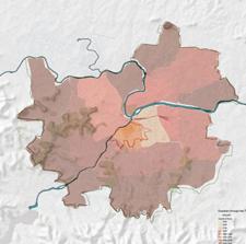


The traditional settlement is along and across the varied physical terrain connecting different small social congregation spaces and common service areas. The Kasba Peth appears to be unplanned in terms of disaster management in the worst climate change situations. Its tiny streets are prone to disaster during rush hour. These tiny streets add up to the character of the area as it is comprised of variety of old wadas and vernacular structures. The small alleys connecting the common public utility spaces, small temples and residential units can be used in celebratory way by including into the planning process. Kasba
21
peth | Structure Plan | Image credits @ Pune Group - 2021 | LAP studio| Pune resilience | Pune Group - 2021 | Semester III CommunityCultureand -Urban formBuilt heritage and housing resiliencePune InfrastructureCapacitybuilding Ecologicalresources
The Kasba peth is the oldest and most vulnerable Peth of Pune that have witnessed rapid transformations from the old core of Kasbe Pune consisting of fishermen, farmers and potters in during Mughal sultanate to Peshwa period suceeded by British empire.
| Community resilience in

22

•
•
•
•
•
•
|
|
•
•
•
•
|
Decentraised and customised temporary markets promoting products with cultural innovations. Adressing covid regulations design strategies in core areas. Restored interdependencies of heritage structures and livelihood patterns. Communtity skillsets promoted for experimental works. Cohesive work environment promoting community involvement and establishing P-P-P development model Cultural development and educating traditional knowledge systems.
Expected outcomes
•
Terrain analysis along Kasba peth Water catchment zones
To identify and establish the traditionally resilient communities patterns, based on occupation and skillsets.
Determining the local issues and vulnerabilities that threaten the living conditions. Strengthen their living conditions and social spaces. Identifying social spaces promoting the economy of those livelihoods. To preserve and promote social cohesion between the ecosystem, and current businesses of livelihoods based on traditional occupations and skillsets, which represent the intangible heritage of core area of Pune.
To promote social wellbeing and developing shared community spaces in order to enhance the living conditions of those traditional communities.
Strategies to be used Restoring a direct B2C buying and selling business plans in order to enhance the economic conditions of traditional markets in the Kasba peth by planning better infrastructure and allocating respective temporary market spaces. Revitalization of the heritage and social spaces along the heritage setting can act as an effective way to meet the demands of the changing times. Improving market conditions as per post covid period guidelines can generate healthy spaces in the crowded areas of Kasba peth.
•
|
|
Surface runoff direction
•
Design intend
23 |


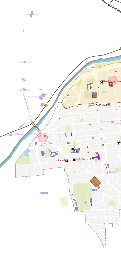
| A | | B | | C | | D | | E | | F | | Identified transitional spaces for setting up cultural markets | Addressing invisiblethe | Upcoming metro station | Identified transitional community spaces along narrow streets | Utilising transitional spaces along the streets for communitytraditionalmarkets A - Exhisting street edge condition along heritage structures. B - Illuminating street edges considering the heritage facades C - Propoer drainage of surface water runoff. D - Rainwater recharge pits at strategic locations. E - Community markets along street edges improving the street character and local engagement. F - Landscaping along the street edge. Including community livelihood patterns in the heritage walks Developing heritage inclusive street edges along the pathwayplanned | Expected increase in metromainmovementpedestrianalongstreetstowardsstation Major traffic Congestion points Mobility network | Schematic sections illustrating design ideas


Internally the Garbhagriha is made of black basalt stone masonry. The structure has brick Shikhara. The plot is densely wooded and has Deepstambha, Samadhi etc. The Deepstambha made in Black Basalt stone is a striking feature of the temple. Timber framed structure with load bearing walls. Wall footing - 2.5 m deep stone masonry (presumption) 0.6m. high basalt stone coursed masonry plinth The walls are brick load bearing walls. The floor on the temple complex is in vitrified tiles.
•
•
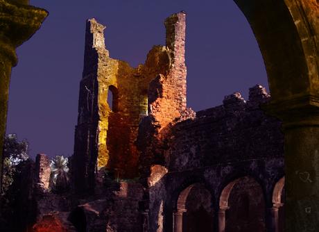
25 conservationArchitectural Kedareshwar Mahadev temple - Grade II B structure | Mumbai03 Project credits : Associated team : Role : Site location : Objectives : Project specifications : (Inventory survey) Value classification Architectural significance Construction details Academic work | Conservation science | 2021. Madhura Zamre. Measured drawing, condition and defect mapping, issue identification, proposal Warddrawings.Gsouth-II, CS No. 137, Dr. Annie Besant Road, Mumbai. • To identify the structural defects of the temple. • Tocarryouttheconditionassesmentbyobservingandanalysingthematerialquality. • Proposals for needful tests for interventions. Site area - 843.9 sq. m. Built up area - 530.3 sq. m. Built in - 1832 C.E. Ownership status - Trust owned Present use - Religious Past use - Religious Usage - Regular use A(arc), A(his), A(cul), B(uu), C(seh), E, J Grade - II B A small scale vernacular style temple with mangalore tiled hip roof supported on carved wooden brackets. The structure does not have much ornamentation on facade and exhibits Vernacular temple architecture of the early 19th century.
•
•
•
26 Existing Photos : GSPublisherVersion 0.1.100.100 D10 Sill 0 430 O1 Sill 0 700 D 1 Sill 0 430 D2 Sill 0430 O2 Sill 0 700 S 02 02 S 01 S 01 W 2 Sill 850 W1 Sill 0 850 D6 Sill 210 D6 Sill 0 210 D6 Sill 0 210 W3 Sill 0 850 W3 Sill 0 850 W3 Sill 0 850 W3 Sill 850 D8 Sill 060 W 5 Sill 850 W 5 Sill 0 850 D 3 Sill 0 210 D 7 Sill 060 D5 Sill 0 000 W 4 Sill 1 000 D11 Sill 0 000 W 4 Sill 1 000 SillW 850 W 5 Sill 850 W 3 Sill 850 W 3 Sill 0 850 D 4 Sill 0 210 W4 Sill 1 000 W4 Sill 1 000 D7 Sill 060 D7 Sill 0 060 D 7 Sill 060 W 5 Sill 850 W Sill 850 10.000 7.500 11.460 4.280 2.675 1.238 1.660 4.280 10.600 3.000 11.460 3.290 3.290 0.290 22.227 +2.460 +2.460 +2.460 +2.460 +2.460+2.460 +2.460 +2.460 +2.460 +2.460 Room- 1 3000 X 3700 Kitchen - 1 4865 X 2680 Room - 2 3000 X 3700 Shiva garbha griha 4200 X 4000 Ganesha garbha griha 2400 X 4380 Hanuman garbha griha 2400 X 4380 Sabha mandapa 10000 X 7500 Kitchen - 2 4865 X 2680 Toilet + Utility 2525 X 6250 Utility 2000 X 1700 Toilet 1200 X 2500 Security 2100 X 2500 Temple Temple2 1 Deep stambha 2 Deep stambha 1 Existing ground floor plan


27 | Condition mapping : 1. Poor lighting conditions 2. Improper rainwater drainage 3. Unplanned services 4. Degraded material finishes 5. Structural cracks in walls 6. Roof dampness / leakages 7. Downgradation of roof members 8. Poor floor conditions 9. Poor plaster condition 10. Door / window downgradation 11. Seasonal algae growth 12. Improper maintainance 13. Redundant use of construction materials 14. Unwanted signages, boards 15. Accessibility GSPublisherVersion 0.1.100.100 Roof plan Condition mapping - defect analysis 11 1 1 1 1111 1 1 2 22 6 6 6 6 66 22 3 44 44 4 5 5 5 5 5 5 4 444 4 4 38888 8 8 8 8 8 8 999 9 9 9 9 9 10 13 131313 1313 1313 1313 13 1313 14 14 15 15 15 15 14 14 14 14 1414 1111 11 1111 1111 1111 101010 10 12 12 1210 9 9 99 99 333 2 2 2 1
28 | Preliminary case for conservation : a - Site clearance. b - Surface cleaning. c - Removing algae growth and scraping. out the cement plaster and oil paints. d - Exposing the wooden structural members. e - Repairing water gutters. 2 1 3 2 1 3 Structural issues in the roof system due to dampness Side Frontelevationelevation 11 1 1 2 2 2 6 66 151313 13 13 13 13 13 13 13 13 10 11 111111 11 11 11 11 11 1111 11 12 12 12 9 9 9 99 1 1 2 2 2 2 2 2 2 2 6 6 6 6 6 6 6 6 7 7 7 7 7 7 7 7 6 6


29 | Proposed restoration changes : 1. Restoring roof structure - replacing degraded structural members, adding waterproofing aluminium sheets, degraded mangalore tiles 2. Removal of additional walls and openings along the original wooden posts in Sabha Mandap 3. Demolition - Storage area, common toilet block, cement frame of compound wall, unwanted steps, gate and cement paver blocks. 4. Removal of redundant materials - Marble flooring, wall tiles, paints on internal surfaces, unnecessary electrical wiring, plumbing lines, cement plaster, cement paver blocks, etc. Proposed plan Existing plan as per required changes Front elevation : Proposed changes Section S-01 : Proposed changes Section S-01 : Required changes in existing condition 1 11111 1 1 1 1 2 2 22 2 2 2 2 2 4 4 4 4 44 4 4 44 4 442 3333 3 33 3 3 33 3333333
30 Vulnerabilities and issues Proposed interventions Sectional view : Proposed changes Sectional view : Required changes in existing plan 11 111 2 2 224 4 4 3
31 Side elevation : Proposed changesDetail at A A Section S-02 : Proposed changesRemoval of unwanted signages and boards Section S-02 : Required changes in existing condition | Proposed changes in the structure : 1. Extension of the roof structure with additional valley rafters on both ends. Additional roof at the entry point of the service quaters. 2. Designed combined toilet blocks and utility for the pandit’s family. 3. Addition of wooden brackets, arches and railing along the facade of Sabha mandap. 4. Restorating wall cracks and plinth damages by using grouting and repointing methods as per need. Adding extended plinth along the external walls inorder to prevent wall dampness. 5. Replacement of contextual / traditional materials and finishes such as lime plaster, kotah stone flooring, organic wall paints, laterite paving blocks, laterite copiing for compound walls, etc. 6. New electrical and plumbing layouts as per the changes in the service locations. 7. Provision of storage area along with common toilet block using contextual materials. 8. Provision of katta and paar for trees along the circulation paths as seating arrangement. 1 44444333 5555 55333 1111 122 662

32Cut-isometric view : Proposed changes Cut-isometric view : Required changes in existing condition 44 44 555555 55 5533 3 33 3 6622 1 1 1 Vulnerabilities and issues Proposed interventions
33 conservationFort Bassein fort | Vasai04 Project credits : Associated team : Role : Site location : Objectives : Historical evolution : Methodology : Case for conservation : Academic work | 2021. Madhura Zamre, Shalaka Kolwadkar, Shifa Sheikh. Tourism management plan, design development and report presentation. Vasai, Mumbai. • To identify and analyse the opportunities for tourist development. • To strengthen the tourist infrastructure through promoting local culture, product and services.600A.D. - 1432 A.D. - Pre Portuguese rule 1432 A.D. - 1533 A.D. - Gujarat Sultanate 1534 A.D. - 1739 A.D. - Portuguese Empire 1737 A.D. - 1739 A.D. - Siege of Vasai 1739 A.D. - 1818 A.D. - Maratha rule 1818 A.D. - 1857 A.D. - British rule ( Treaty of Bassein - 1802 A.D. ) 1857 A.D. - Till date - Archaeological Survey of India 1 Preservation in its present state. 2 Surface cleaning and defect treatments as per structural requirements. 3 Repairing cracks on walls and floors. 4 Reducing vehicular movements. 5 Preventing vandalism and setting up monitoring systems. Heritage identification Tourism activities Formulating policies Case for CirculationconservationandzoningDesign SignagesIlluminationelementsMuralsSeatingsMappingValuing Significance Risk assesment Human cause strategiesDesign Natural cause
34 Mapping historic developments and associated human activities during different periods Present fortified wall Portuguese period Maratha period British period After independence 1 2 3 4 5 6 7 8 9 10 1311 14 13 13 12 01 Vasai fort percinct 02 Rampart wall 03 St. Anthony’s church 04 Church of Holy name of Jesus 05 The Citadel 06 The Church of our Lady of Life 07 The Jail 08 Chimaji Appa temple 09 Martiz of St. Josheph 10 Vasai fishing jetty and drying grounds 11 Pachu Bandar 12 Vasai creek 13 Bus stops 14 Access point


35 | Proposed circulation and zoning 1 Open parking area. 2 Ticketing counter and security quarters. 3 Fort information center + admin office. 4 MTDC Canteen and toilet facilities. 5 Temporary fish markets. 6 Open ground with planned workshops by Koliwada community and permitted public activities. 7 Feast day celebration area. 8 Tourist points with guide services. 9 Water sports and entertainment facilities. 1 2 3 4 5 6 7 8 9 Bird watching poiints Redeveloping bus stop using Illuminationmaterialscontextualpoints Vehicular circulation zone Bus Pedestrianroute tourist path Nature Strategictrailseating locations
36 | Mural installations depicting hitorical facts |
Measures to be taken in the tourism development plan Community awareness about the heritage significance and need for controlled human cultural activities.
Public-Private Partnership (PPP) assumes greater significance in the conservation and management of our monuments and this can be encouraged. Local communities to be taken into decision making processes. Preparing for structural audits and reports in order to define the carrying capacities for each monument. Visitor management to be controlled according to the structural capacity of the monuments.
| Illumination points | Before | After


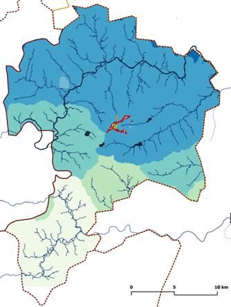
37 conservationFort Samangad fort and cultural landscapes of Omkar pathar | Gadhinglaj05 Project credits : Associated team : Role : Site location : Objectives : Proffessional work | I.I.A. Kolhapur | 2022 Ar. Vijay Korane (Head), Prof. Vandana Pusalkar (SPSMBH’s COA), Ar. Kalyani Rawal On-site documentation of cultural resources, measured drawings and site inventories, interviews and questionaire surveys, conservation and tourism management plan, design development, block estimates and report presentation. Gadhinglaj city, Kolhapur district, Maharashtra. • To identify and study the cultural heritage at the regional level. • To analyze salient features and architectural character inorder to [Re]store the historic fabric of the Samangadh fort and Omkar Pathar. • To integrate heritage conservation and tourist infrastructure in the sustainable development through promoting local culture, product and services. | Delineating buffer zone| Regional map Gadhinglaj Hukkeri taluka Hidkal reservoirHiranyakeshi river Chandgad taluka Ajra taluka | Connectivity GadhinglajOmkar pathar highwayNH4 Sankeshwar


38 | Larger basins and watershed with respect to stream orders | Contour mapping demonstrating nearby hills | Buffer zone comprised of relevant water bodies and smaller basins around the ridge line Panaromic view from Sondi buruj


| Old settlement of Chinchewadi village | New settlement of Chinchewadi village | Pathway through stairs | Identified site for tourism development | Identified site for cultural development | Hasursasgiri village settlement | To Gadhinglaj 1 2 63 14 15 16 18 17 17 19

40 01. Entry point 02. Zhenda buruj 03. Vetal buruj 04. Sondi buruj 05. Gateway 06. Andhaar kothdi 07. Saat kaman vihir 08. Sakhar vihir 09. Gola barud satha 10. Chor khind 11. Sauch kup 12. Uttar khaan + Vihir 13. Mughal tekdi 14. Shiv mandir guha 15. Bhimsasgiri talao 16. Omkar shila 17. Foundation wall of the unbuilt fort 18. Bhimshappa matha 19. Hanuman mandir | Naukud settlementvillage | Proposed nature trail along the caves locations | Core area | Identified view points providing cultural or historical significance | To Sankeshwar | Khamehattivillagesettlement 4 5 87 9 10 11 12 13 | Mapping cultural resources and heritage


41 Plan at lower level Plan at higher level Section 2 Section 1111 0 5 10 m 1 2222 |Saat Kamaan Vihir | Comparitive material tests identified for differently sized stone samples of all the structures: 1 Colour analysis -Based on Munsell system. 2 Wet chemical test -Mineral composition. 3 UV Floroscence test -Weathering process. 4 Compressive strength test -for different sized stones. 5 Water absorption test -Through total immersion. 6 Flexural strength -Three point bending test. 7 Water permeability -Water vapour transmission. |
Sample preparation 2 inch cubes - ( 5 nos. at different locations ) - per structure selected at 5 different levels. A stone cutting machine with a 4inch diamond disc water cooled blade. After being cut, the samples to be briefly washed to eliminate any surface soil wash and the sun dried completely before being testing. Based on expert opinions and case study examples )
(


42 Plan at higher level Plan at lower level Section 1 Section 2 0 5 10 m 1 1 1 1 2 2 2 2 |Andhaar Kothdi | Case for conservation 1 Preservation in its present state. 2 Surface cleaning and defect treatments as per structural requirements. 3 Removal of redundant materials using traditional methods. 4 Demolition of existing non contextual pavements, cement plaster work, tile work, metal staircases and bridges for all significant structures 5 Rainwater and stormwater management. 6 Restoring tehalni paths and fortification walls based on risk assesment and structural analysis report. 7 Expert investigations including geologists, archaeologist, historians, environmentalist, biologist, etc. 8 Establishing traditional trade routes and cultural linkages based on the available historical evidences. 9 Water purification in the vihir and khaan using appropriate biological resources.


43 Phase - 1 C-1V-1T-1 Phase - 2 C-2V-2T-2 Phase - 3 C-3V-3T-3Plan Image credits for Shiv mandir @ | Ar. Kalyani Rawal | checked and edited by Prof. Vandana Pusalkar | rendered by author Section 3 Section 2 Section 1 11 22 3 3 0 5 10 m |Shiva mandir guha


44 | Strategies and visions C-1 | Fort conservation C-2 | Caves conservation C-3 | Preservation of the site components in their present state C-4 | Ecological conservation C-5 | Biodiversity conservation C-6 | Heritage conservation V-1 | Community awareness and networking V-2 | Developing basic village facilities V-3 | Green energy development V-4 | Developing sustainable water resources V-5 | Promoting organic and traditional agricultural practices V-6 | Native tree plantations T-1 | Establishing signages, information boards, GIS mapping T-2 | Establishing various kinds of tourism trails T-3 | Creating brochures and information documents. Tourism marketing T-4 | Tourism facilities through tourist facility centers T-5 | Promoting cultural festivals, practices, cuisines, lifestyles, local food, etc T-6 | Heritage and tourism management Phase - 4 C-4V-4T-4 Phase - 5 C-5V-5T-5 Phase - 6 C-6V-6T-6 Framework : Natural CulturalHeritageHeritage Tangible Archaeological sites Fort components Religious sites Natural resources Festivals Conservation ( C ) Social practices Village development ( V ) Cultural practices Tourism development ( T )IntangibleTangibleSustainabletourism


Residential bungalow | Kolhapur06projectsArchitectural Project credits : Role : Site location : Objectives : Project specifications : Freelance individual project | 2021 Preliminary design and finalisation, sanctioning, working drawings, building services layouts, on site supervision and maintaining R.A. bills. RS.No.1116/1B/14/ Plot no. 2, Hariom Nagar, Kolhapur - 416010 • To promote sustainable and cost effective building construction techniques. • To acheive effective and workable spans using R.C.C. frame structure. • To promote natural and ecofriendly material finishes. Site area -1058 sq.ft. -23 ft x 46 ft Offset margins -2.25 m (front) -1.5 m (back) Stilt floor plan First floor plan Second floor plan 1113432 1313 56 8 1416 16 1515 7 7 1011 129 181317


46 10. Handwash 11. Kitchen 12. Utility 13. Staircase | Second floor plan14. Children bedroom 15. Attached toilet 16. Terrace 17. Master bedroom 18. Balcony FrontSectionview Filler slab Rat trap bond Front elevation


47 | On site photos during construction


48


49 projectsArchitectural Farmhouse at Khadakwasla | Pune07 Project credits : Associated team : Role : Site location : Objectives : Project specifications : Eco Solutions pvt. ltd. | Office work | 2019 Ar. Anshul Gujarathi (Director) Preliminary design and finalisation. Plot no. 28, Near wilderness hilltop resort, Khadakwasla, Pune - 411025 • To promote extrovert planning method. • To achieve solar passive design principles in the development process. Site area - 51200 sq.ft. -320 ft x 160 ft 01. Parking area 02. Verandah 03. Entance lobby 04. Storage and maintenance 05. Powder room 06. Living room 07. Open kitchen + dining 08. Open dining area 09. Servants quarters + att. toilet 10. Staircase 11. Open courtyard 12. Bedrooms (3 nos,) + att. toilet 13. Family room 14. Terraces 15. Bedroom + att. toilet 16. Skylights Ground floor plan First floor plan Roof plan 1 32 4 14 14 14 14 14 141414 9 10 11 16 1616 15 1212 125 6 137 8 | Ground floor plan | First floor plan

50 Longitudinal site section Isometric view

51 projectsArchitectural Mixed-use residential appartment | Dhule08 Project Associatedcredits:team : Role : Site location : Objectives : Project specifications : Eco Solutions pvt. ltd. | Office work | 2019 Ar. Anshul Gujarathi (Director) Preliminary design and finalisation. Dhule, Maharashtra. • Compact planning using maximum livable area compliant for RERA registration. Site area - 5040 sq.ft. -56 ft x 90 ft Requirements - 2BHK -7 nos. - 2.5BHK -3 nos. - Shops -2 nos. - Parking -10 cars, 25 two wheelers + visitor parking space. Services - Lift, staircase, common passages, service duct, maintenance room. Stilt floor plan Typical floor plan (1st and 2nd) Third floor plan 01. Entry points 02. Parking area 03. Staircase and lift 04. Shops 05. Living room 06. Kitchen 07. Bedroom 08. Study 09. Terraces 44 11 1 22 2 22 2 3 38 8 5 5 5 5 5 9 5 9 6 6 6 666 7 7 7 777 7 7 7 777 3
IsometricSection view Side elevation Front elevation 1 1 1 41 4 2 2 9 9


53 Other works Architectural documentation works | Hand done works09 | Documenting street elevation and character for study tour | Fountainhas, Goa (2015) | Documenting traditional wada for L.I.K nasa trophy | Kinhai village, Satara (2015) | Roof plan | Old Kinhai village


54 | Isometric view of Shri Kopeshwar Mandir for study tour | Saswad, Maharashtra (2014) Nandimandap Entranceway SabhamandapAntarala Garbhagriha

Thank you +91 8975610681 | gaurishdeshpande2123@gmail.com