
Open House!
TWO PROJECTS, ONE PROCESS
The Coastal Resilience Plan is a strategy designed to help communities in Stamford prepare for and adapt to the impacts of climate change, particularly coastal hazards like sea level rise, storm surge, and flooding. The project area includes neighborhoods mostly south of the I-95 and in the “Coastal Area Management” boundary.
The Cummings Pond area, like other coastal regions in Stamford, is at risk from both current and future flooding, including the combined impact of coastal and rainfall-driven flooding. Stamford’s Coastal Flood Resilience Plan address coastal flood risks across the entire coastal area, while a detailed assessment of stormwater flooding will also be included in the Cummings Pond sub-area.
WHAT WILL THE PLAN DO?

Establish an updated understanding of current and future coastal flood risk

HOW DOES THIS PROCESS UNFOLD AND WHAT’S THE TIMELINE?

TODAY’S OPEN HOUSE
Over the next 10 months, the Project Team is working to analyze coastal flood risk, evaluate impact on critical infrastructure and community assets, generate concept level design alternatives, and develop a final plan to help Stamford reduce risk and take action.

Learn about the coastal resilience planning process, investigate areas and neighborhoods at risk of coastal flooding, and share your vision for a more resilient Stamford.
Your participation will guide the plan’s vision, inform design concepts, and provide the planning team with valuable feedback about your lived experience with flooding in the city.
a
Prioritize
OUR TEAM HOW TO STAY INVOLVED?
We’d like to hear from you throughout the process. We will be hosting community workshops throughout the project, and updates will be shared on the project’s website.


The City of Stamford and a Technical Advisory Committee is working with Fuss & O’Neill, SCAPE Landscape Architecture, and Woods Hole Group over the next year to reduce risk & take action against growing coastal flood risks.


1 UNDERSTANDING FLOODING & CLIMATE CHANGE
COASTAL FLOODING INLAND FLOODING
The Coastal Resilience Plan will use coastal flood modeling by the Connecticut Institute for Resilience & Climate Adaptation (CIRCA) to map exposure and evaluate flood risk.

HIGH TIDE FLOODING occurs in low-lying coastal areas. This type of flooding occurs during normal high tides or extreme high tide events (e.g., king tides or spring high tides).

COASTAL STORM FLOODING occurs during coastal storms like hurricanes and Nor’easters. It includes the effects of storm surge and waves.
HOW WILL CLIMATE CHANGE IMPACT COASTAL FLOODING?

Stamford will also experience increased coastal flooding due to sea level rise. Sea level rise will increase the height of tides, leading to more tidal flooding and increasing water levels during a coastal storm.
You can use CIRCA's Connecticut Sea Level Rise and Storm Surge Viewer to see areas that will be inundated at high tide and coastal storms with 20" of sea level rise.
WE WANT YOUR FEEDBACK!
HOW IS FLOODING IMPACTING YOUR DAILY LIFE? WHAT TYPE OF FLOODING CONCERNS YOU THE MOST?
Use the yellow stickies to mark your responses.


In addition to modeling coastal flood risk, the Cummings Pond Sub-area will develop an additional model to study and evaluate stormwater flooding.

STORMWATER FLOODING results from rainwater piling up in areas with poor drainage. This often happens during heavy rainfall events, when drainage systems become overwhelmed and/or the rainwater cannot infiltrate the ground quickly enough.

RIVERINE FLOODING occurs when water in rivers, creeks, canals, or swales overtop their banks. This can happen due to local heavy rainfall and can also result from rainfall upstream.
HOW WILL CLIMATE CHANGE IMPACT INLAND FLOODING?

Stamford will experience more inland flooding due to increasingly intense rainfall events (precipitation) and the associated stormwater runoff.
The impacts of stormwater flooding will be studied only in the Cummings Pond Subarea Plan.


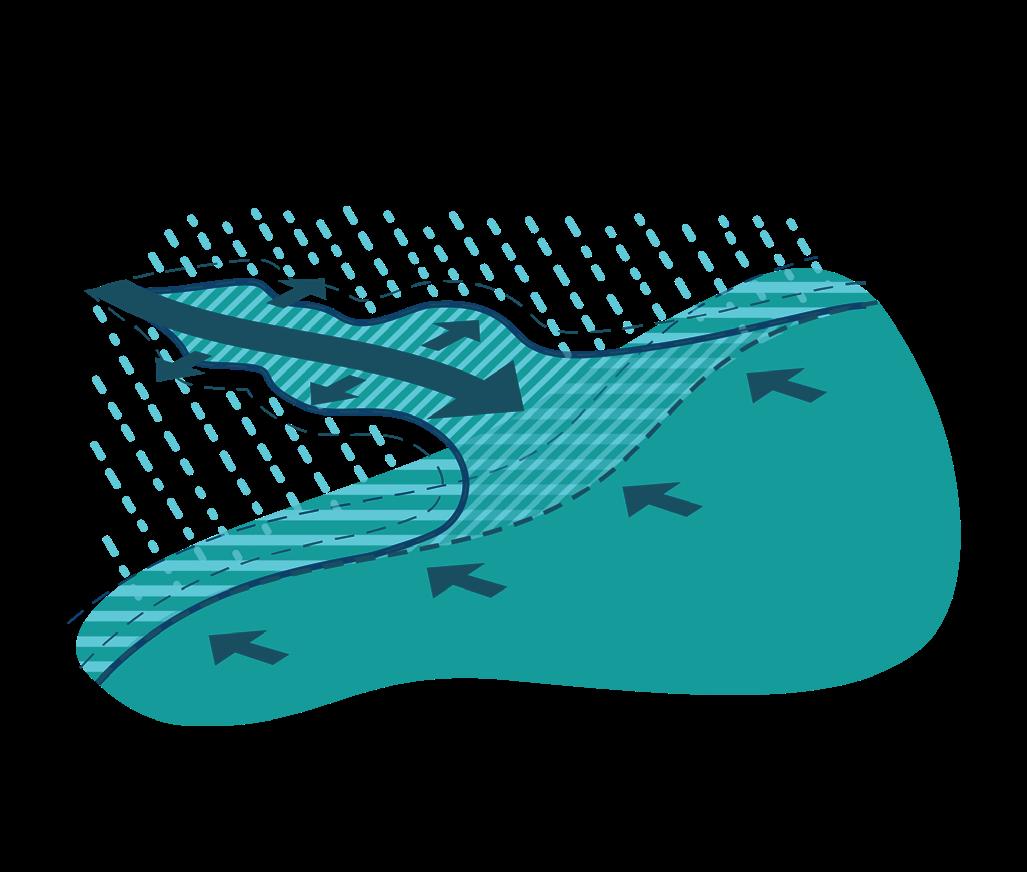


Coastal and inland flooding can combine to create compound flooding
2 COASTAL FLOODING IN STAMFORD
SHORELINE?


HURRICANE BARRIER
FRINGE FLOODING AT WEED AVENUE
3 WHY DOES IT FLOOD IN STAMFORD?

As the dense ice that forms glaciers retreat, it leaves behind glacial sediments that create a complex shoreline. During the last glacial period, the Laurentide Ice Sheet covered much of Connecticut. The retreat of the glaciers left behind a variety of glacial sediments, including till and outwash plains contributing to this diverse topography. These materials, deposited as the ice melted, formed the base upon which the modern coastline is built.

As glaciers melted and sea levels rose, sandy beaches were formed as a result of wave action grinding down and redistributing the materials left by the glaciers. The CT coastline is also characterized by salt marshes, particularly around creeks and inlets. These marshes are formed from sediments deposited by tidal waters and are crucial for their ecological services, acting as buffers against storm surges, nurseries for marine life, and filters for pollutants.
HOW DOES TOPOGRAPHY IMPACT FLOODING?
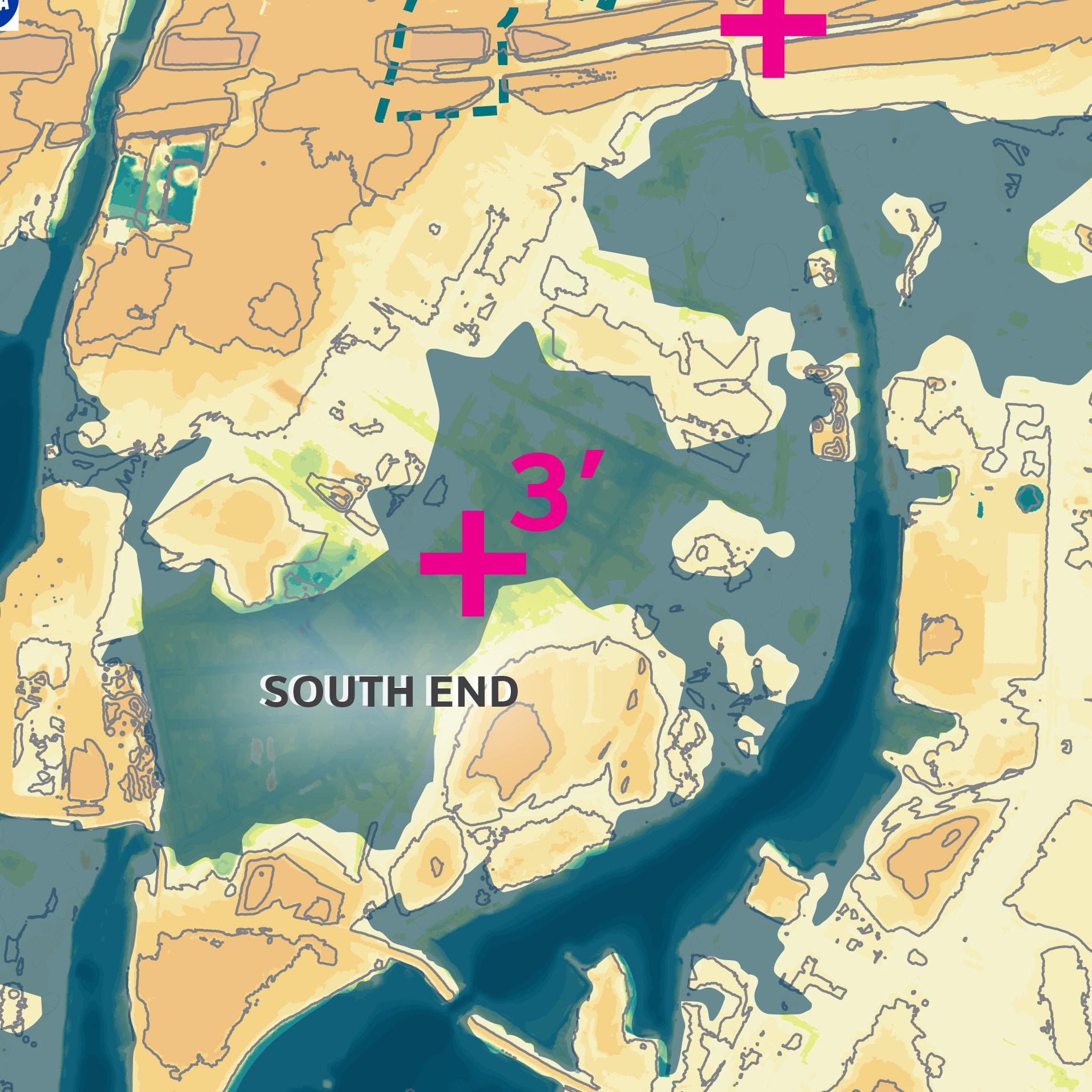


4 COASTAL FLOOD RISK TODAY & TOMORROW
with 20’’ of Sea Level Rise) (Present Day with No Additional Sea Level Rise)


(2100s with 40’’ of Sea Level Rise)


5 WHERE ARE YOUR FLOODING CONCERNS?


FLOODING CONCERNS?


IDEAS WALL
WE WANT YOUR FEEDBACK!
WHAT DO YOU THINK THE CITY SHOULD DO TO ADDRESS FLOODING IN YOUR COMMUNITY? Use the yellow stickies to capture your thoughts.
A VISION FOR THE COASTLINE
How do you use the waterfront today? Flood risk reduction also provides an opportunity to re-imagine and improve how we use our coastline. What would you like to see more of in the future?