Adaptation Strategies for Downtown Mystic

FEBRUARY 23, 2025


FEBRUARY 23, 2025
REVIEW CURRENT AND FUTURE CONDITIONS
MITIGATION TOOLKIT


John Truscinski – CIRCA Project Lead
Nicole Govert - CIRCA Community Resilience Planner
Mary Buchanan - CIRCA Community Resilience Planner
Yaprak Onat – Modeling support
Town of Stonington
Danielle Chesebrough, First Selectperson
Deborah Downie, Selectperson
Clifton Iler, Town Planner
Molly Evak, Town Grant Administrator
Citizen + Technical Advisory Committee (CTAC)

Beth Kirmmse, RLA, WEDG Project Manager
Consultant Team – Fuss & O’Neill


Address critical transportation and resilience corridors
Address shoreline/waterfront challenges: flood risk reduction, historic preservation, support tourism
Reduce the impacts of extreme heat
Integrate nature-based solutions + green stormwater infrastructure to realize multiple benefits


Understand and communicate relative risks
Engage the community to create the vision
Develop alternatives based on risk mitigation and cost
Position projects for implementation using identified state and federal funding


CIRCA: Resilient Mystic project contributes to a growing body of work studying climate adaptation in the surrounding area! Past and present studies and reports reviewed by the project team include:
Vulnerability Assessments
Hazard Mitigation Plans
Comprehensive Plans
Watershed Resilience Action Plan
Lantern Hill Road Study
Haley’s Brook Watershed Study
LISFF: Resilient MysticGroton
Sea Grant Planning Track 1: Watershed Climate Vulnerability Assessment
Boathouse Park Living Shoreline


CIRCA: Resilient MysticStonington 2024-25


Boundary follows a natural floodplain on the Stonington side of Downtown Mystic, surrounded by tidal waters
• Due to topography and orientation, the Stonington side is more flood-prone than the Groton side
Many critical facilities in the project area along with regional transportation infrastructure and historic + cultural resources

Much of the project area is at elevations of 10 feet above sea level (NAVD88) or lower, with a steep hill rising to the east
This topography of this area is shaped by a long history of coastal geologic processes, such as glaciation, erosion, and tectonic activity
Human intervention has also shaped Downtown Mystic’s current and future flood vulnerability, with access to the water critical to Mystic’s identity and economic prosperity
Shoreline armoring and coastal fill have been used to expand the developable area and reduce erosion

Hardened shoreline defense structures are widespread today
Bulkheads and revetments reduce wave action and retain land for human use
• These structures’ current elevations are unlikely to protect Mystic from sea level rise or future storm surge

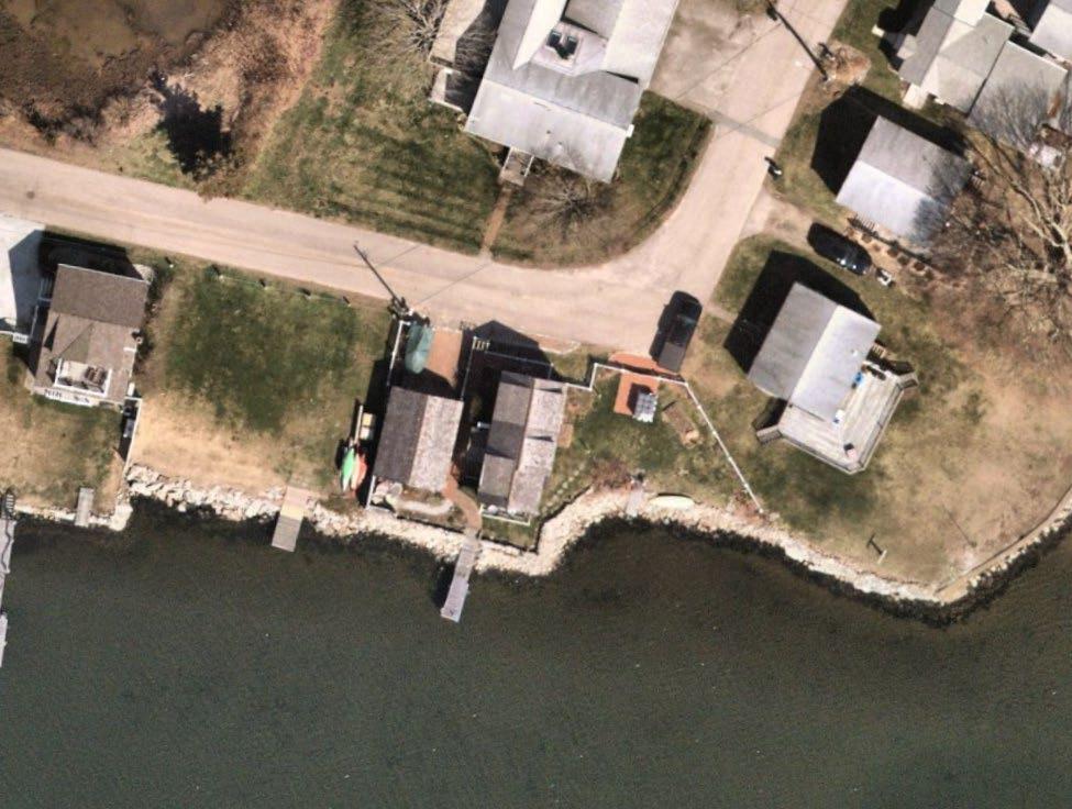

Vertical bulkheads protect roads and the Mystic Seaport Museum Riprap surrounds private homes along Mystic Harbor Piers and Transportation Causeways at the Mouth of the Pequotsepos River

SEA LEVEL RISE & TIDAL FLOODING
(Chronic/Nuisance Flooding)
STORM SURGE FLOODING (Periodic Flooding)
This project used modeled coastal flood data provided by CIRCA to evaluate where and under what conditions flood vulnerability is highest in Downtown Mystic

PRECIPITATION AND DRAINAGE FLOODING
The 10% annual exceedance probability (AEP) flood is a flood event that has a 10% probability of being equaled or exceeded each year.
The 1% annual exceedance probability (AEP) flood is a flood event that has a 1% probability of being equaled or exceeded each year.


Flood Depths: Present Day 10% AEP Flood

Flood Depths: Present Day 1% AEP Flood
FEMA Flood Zones reveal areas of current and historic flood vulnerability, with the 1% flood zone covering most of the project area

Elevation and floodproofing requirements apply to construction on structures within the AE and VE zones, although exceptions may apply to historic buildings


Flood Depths: 1% AEP Flood with 20” Sea Level Rise

Mean Higher High Water (MHHW) with 1 m (3.3 ft.) of Sea Level Rise in 2100.
This represents the upper bound (95% confidence interval) of the likely range of sea level rise in 2100 for the Long Island S ound.
Downtown Mystic is heavily urbanized, with over half of the project area covered in concrete or asphalt
Heat waves can cause health issues and compound the hazards of coastal flooding
Climate change is expected to increase the frequency and duration of heat waves


The number of days reaching 90° F annually in eastern Connecticut is expected to increase over time due to climate change (U.S. Climate Resilience Toolkit Climate Explorer 2024).


Hundreds of buildings could be affected by coastal flooding in the future with sea level rise, bringing direct and indirect impacts such as residential displacement, business closures, or lost access to critical facilities
Coastal flooding in Downtown Mystic is expected to bring widespread impacts to local and state roads, with automobile travel not advised at depths greater than 6”
Flooding along Routes 1 and 27 would require advanced evacuation notice

Impacts to the train station, tracks, and related equipment
Coastal flooding and sea level rise can overwhelm the sanitary sewer system and wastewater treatment plant

Wastewater treatment plant located in potentially high-risk flood zone with deep (3+ ft), fast-moving water
Elevated water levels from flooding can prevent stormwater systems from draining and send ocean water into streets via storm drains

Critical community assets (public resources improve the health or general quality of life for Mystic’s residents) and tourism/recreation assets
Municipal assets directly impacted by the 10-year + 20” SLR flood extent include the post office, wastewater treatment plant, and fire department
Mystic Bridge Historic District contains hundreds of historic properties in Stonington at risk of flooding

Special considerations apply to mitigating coastal flood damage to historic structures
Maintaining Mystic's historic character will need to be balanced with the need to make changes to structures and the landscape to address flood risk
Numerous and sometimes overlapping regulatory jurisdictions throughout the project area

The project team will use this information to guide the selection of climate adaptation concepts
Tidal flooding is the temporary inundation of low-lying areas due to high tides. Sea level rise will cause tides to be higher than they are today, and some areas will flood daily if no actions are taken.
Tropical storms, hurricanes, and nor’easters can raise water levels along the coast.
Inches of rain can fall in a few hours during the peak of a storm, causing flooding in lowlying areas. These areas might be along waterways (riverine flooding) or inland where rainfall overwhelms storm drains.


Nature-based solutions use natural systems, or features that mimic them, to reduce flood risk and provide other economic, environmental, and social benefits. Natural features include existing ecosystems, such as wetlands and salt marshes, while nature-based solutions include features like parks and living shorelines. Both can maintain or create valuable habitat, attenuate wave action, and reduce erosion.


Bulkheads are concrete structures along shorelines of large bodies of water that protect from flooding, wave action and erosion. Elevated bulkheads can be integrated into recreational greenways and provide waterfront access to users.


Elevated promenades provide public access to the shoreline and are raised to the Design Flood Elevation (DFE) level to protect inland communities from coastal flooding.


INFILTRATION


A green roof is a layer of growing medium for vegetation installed over a waterproofing system, slowing down runoff by retaining rainwater and gradually releasing it back into the atmosphere through condensation and transpiration. Blue roofs provide temporary water storage systems that allow for the gradual release or evaporation of stored water.


Relocating critical systems to higher floors within structures reduces the impacts of flooding on critical services and reduces recovery times. This tool increases the resilience of essential services to homes and businesses.


Wetproofing involves sealing susceptible levels to water infiltration. This allows for flood water to move into and through these levels while limiting infiltration to the rest of the structure. Dryproofing involves fully blocking out floodwaters with both permanent and deployable structures.

Strategic acquisition is the voluntary acquisition of parcels to reduce long-term flood damage and implement targeted flood protection projects at key flood pathway locations. This strategy can be selectively considered where perimeter protection or adaptation are not feasible, too costly, or detract from other essential aspects of resilience.


POTENTIAL REDEVELOPMENT AREA
OUTFALL IMPROVEMENTS / DAYLIGHTING
MILL RIVER TRAIL
ELEVATED JOHN W. MURPHY DRIVE AS FLOOD RISK REDUCTION
FLOODABLE PARK
NEIGHBORHOOD GATEWAY
ELEVATED BOARDWALK
LIVING SHORELINES
ELEVATED GRAND AVE + BRIDGES
ELEVATED BOARDWALK
FLOODABLE PARK
ELEVATED ROAD AS FLOOD RISK REDUCTION


This Waterfront District Vision aims to leverage the proposed flood mitigation options into community co-benefits. The proposed solutions provided in the following pages show how the proposed flood mitigation solutions (i.e. flood wall and road raising) could create opportunities for business to increase revenue and dwell time while also providing energizing spaces for the community to gather and enjoy the waterfront while maintaining all critical functions to serve the adjacent properties.


WE WANT TO HEAR FROM YOU!

WE WANT TO HEAR FROM YOU!
Feel free to respond in the Teams chat!
WE WANT TO HEAR FROM YOU!
What are your hopes for the next generation in Mystic?
Feel free to respond in the Teams chat!